Embed Size (px)
Citation preview
South Coast Region Parks and Outdoor Recreation Division
Ministry of Lands, Parks and Housing
SHANNON FALLS PROVINCIAL PARK
MASTER PLAN
DECEMBER 1985
TABLE OF CONTENTS
Page PART 1: SUMMARY AND BACKGROUND A. Plan Summary.........................................................................................................................1 B. Regional and Provincial Context ............................................................................................2 C. Resources ................................................................................................................................4
1. Natural Resources ..........................................................................................................4
a) Natural Region/Regional Landscapes......................................................................4 b) Climate .....................................................................................................................4 c) Physiography............................................................................................................5 d) Water ........................................................................................................................5 e) Vegetation................................................................................................................6 f) Wildlife ....................................................................................................................6
2. Cultural Resources .........................................................................................................6
3. Visual Resources............................................................................................................6
4. Resource Analysis..........................................................................................................8
a) Opportunities and Constraints..................................................................................8 b) Significance to Park Goals.......................................................................................8
D. Land Tenures, Occupancy Rights and Jurisdictions ...............................................................9 E. Existing Facilities....................................................................................................................9 F. Marketing Analysis ...............................................................................................................11
1. Existing Use .................................................................................................................11 2. Supply Information......................................................................................................12 3. Demand Information....................................................................................................13 4. Conclusions ..................................................................................................................13
G. Park Issues.............................................................................................................................14

PART II: THE PLAN Page
A. Purpose/Objective .. ....................................................................................................15 B. Zoning .. .......................................................................................................................16 C. Development Plan .......................................................................................................16 D. Management Policies .. ................................................................................................18
a) Resources .. ............................................................................................................18
i) Land .. ..............................................................................................................18 ii) Water.. ..............................................................................................................18 iii) Vegetation.. ......................................................................................................18 iv) Fish and Wildlife.. ............................................................................................18 v) Visual Resources..............................................................................................18
b) Public Uses.............................................................................................................19
i) Recreation.. ......................................................................................................19 ii) Special and other uses.. ....................................................................................19
E. Marketing and Information Program Strategy.. ....................................................................20 Bibliography................................................................................................................................... (i)
LIST OF FIGURES Figure 1 Regional and Provincial Context.. ...........................................................................3 Figure 2 Park Resources Map.................................................................................................7 Figure 3 Existing Development............................................................................................10 Figure 4 Proposed Development Map.. ................................................................................17
LIST OF TABLES Table 1 Developed Recreation opportunities around Squamish.........................................12

1
PART 1: Summary and Background A. Plan Summary
Shannon Falls, the t hird highest waterfall in British Columbia, represents a special natural feature component of the Rugged Pacific Ranges Regional Landscape. Situated 3 kilometres south of Squamish, the 15 ha park is enjoyed annually by over 200,000 visitors, making it one of the most heavily used picnic area/highway rest stops for its size in the province. Although significant park resources are limited, there are many opportunities to introduce new park experiences. This plan proposes to fully utilize all park resources to develop and manage a provincially significant day use destination site.
PHOTOGRAPH NOT AVAILABLE
2
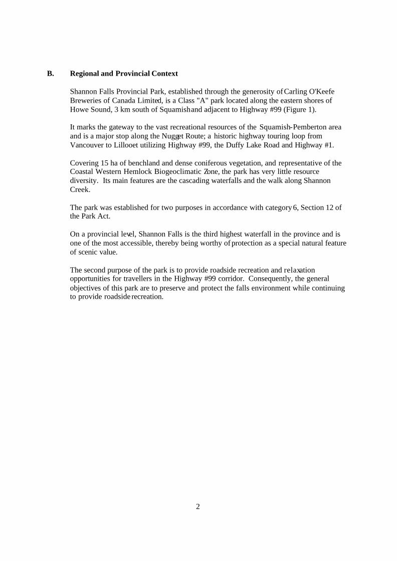
B. Regional and Provincial Context Shannon Falls Provincial Park, established through the generosity of Carling O'Keefe Breweries of Canada Limited, is a Class "A" park located along the eastern shores of Howe Sound, 3 km south of Squamish and adjacent to Highway #99 (Figure 1). It marks the gateway to the vast recreational resources of the Squamish-Pemberton area and is a major stop along the Nugget Route; a historic highway touring loop from Vancouver to Lillooet utilizing Highway #99, the Duffy Lake Road and Highway #1. Covering 15 ha of benchland and dense coniferous vegetation, and representative of the Coastal Western Hemlock Biogeoclimatic Zone, the park has very little resource diversity. Its main features are the cascading waterfalls and the walk along Shannon Creek. The park was established for two purposes in accordance with category 6, Section 12 of the Park Act. On a provincial level, Shannon Falls is the third highest waterfall in the province and is one of the most accessible, thereby being worthy of protection as a special natural feature of scenic value. The second purpose of the park is to provide roadside recreation and relaxation opportunities for travellers in the Highway #99 corridor. Consequently, the general objectives of this park are to preserve and protect the falls environment while continuing to provide roadside recreation.
3
4
C. Resources 1. Natural Resources
a) Natural Regions and Regional Landscape
Shannon Falls is a minor landscape component in the Rugged Pacific Ranges Regional Landscape of the Coast Mountains Natural Region. Its granite walls and vegetative pattern are only a few characteristics of this landscape. Garibaldi Provincial Park contains all the characteristics of the Rugged Pacific Ranges Regional Landscape and satisfactorily represents the unit in the Province.
PHOTOGRAPH NOT AVAILABLE
b) Climate The climate in this area is typical of the south coast with mild wet winters and warm sunny summers. Mean average daily temperatures range from 23 degrees Celsius in July to 4 degrees Celsius in January with a May to September summer season mean of 15 degrees Celsius. Precipitation averages approximately 130 - 150 centimetres per year.
5
c) Physiography The physical structure of the park is essentially composed of Coast Range Batholith modified by glacial scouring. Thousands of years ago glaciers scoured the overburden leaving exposed granite walls rising hundreds of metres above sea level. Soils are generally coarse sands and gravels with a thin layer of organic soils. The terrain of the park is divided into two benches with an elevation difference of approximately 10 metres. The largest bench covers over 10 ha and is divided by several small creek gullies.
PHOTOGRAPH NOT AVAILABLE
d) Water
Shannon Creek originates from Mount Habrich and Mount Sky Pilot; a drainage area of approximately 23 square kilometres. Despite extensive logging in the drainage system, the water guality remains clear and free from runoff material. Most of the creek bed area is free from debris. The side channels at the base of the falls is the only area with significant rock rubble and wind fall, Seasonal water flows have not been recorded; however, signs in the field indicate a seasonal peak depth increase of approximately .5 metres. This peak flow has caused minor bank erosion at various points along Shannon Creek with major bank undercutting occurring just beyond the park boundary adjacent to the highway bridge.
6
e) Vegetation Shannon Falls is within the Douglas Fir, Western Hemlock subzone of the Coastal Western Hemlock Biogeoclimatic Zone. The park is forested primarily with a modified variation of the characteristic zone species including Douglas Fir (Pseudotsuga menziesii), Western Hemlock (Tsuga heterophylla), Western Red Cedar (Thuja plicata) and successional species such as Red Alder (Alnus rubra). All the virgin timber has been logged with many of the remaining stumps nursing young growth. There are also several introduced ornamental species that provide landscaping for various park facilities. f) Wildlife Resident wildlife species including fish are insignificant at this site.
2. Cultural Resources
Throughout the park area there is some evidence of the logging activity that occurred here roughly 75 years ago. A number of excellent spring board notches on old stumps are scattered throughout the forested area and much of the deadfall also exhibits evidence of the logging techniques of the period. In addition, a wooden waterwheel reconstruction (circa 1800), a metal and wood steam donkey (circa 1900) and a variety of logging machines (circa mid 1900’s), although not indigenous to the site, have some cultural value.
3. Visual Resources
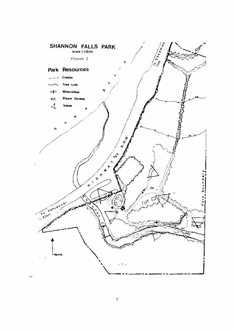
Two major visual experiences are apparent at Shannon Falls (Figure 2). The first and most significant is the waterfall. Visitors can experience a variety of waterfall views ranging from a distant perspective from a vehicle passing by on the highway, to the dramatic experience at the base of the falls. The second visual experience is found along the Shannon Creek Trail. A dense overhead tree canopy, vertical walls formed by the vegetation on the opposite stream bank and nearby steep slopes enclose the visitor in a tunnel of natural sights and sounds.
7
8
4. Resource Analysis
a) Opportunities and Constraints
Future expansion of recreational opportunities at Shannon Falls Park are severely constrained by limited land area, natural resources and market parameters. There remains, however, the opportunity for visitors to utilize the many other public and private recreational facilities on the adjacent properties if trail connections could be established. These linkages could attract people to Shannon Falls for day outings. Connections with the Stawamus Chief would provide park visitors easy access to day hiking and mountain climbing opportunities while access to the private campground across the highway would bring visual access of Howe Sound and food services within the convenient reach of park visitors. In addition to these opportunities there is the potential within the park to improve visual access to the falls as well as provide visual access to the Tantalus Mountain Range directly across Howe Sound.
b) Significance to Park Goals
Within the context of the Parks and Outdoor Recreation Divisions Conservation and Recreation Goals, Shannon Falls addresses these goals in the following ways: Conservation Shannon Falls is the third highest waterfall in the province and consequently is a special natural feature of provincial significance. The park's geographic location and exposed granite cliffs are secondary characteristics of the Rugged Pacific Ranges Regional Landscape and consequently support the representations of this provincially significant landscape. Recreation: Tourism The walking, picnicking and viewing opportunities at the park assist in diversifying the passive and active day use opportunities available in the Highway #99 Corridor. These opportunities also compliment those available in the lands adjacent to the park.
9
D. Land Tenures, Occupancy Rights and Jurisdictions
The sole alienation is an easement to B.C. Hydro for a hydro transmission line which slightly encroaches on the southern boundary of the park.
E. Existing Facilities
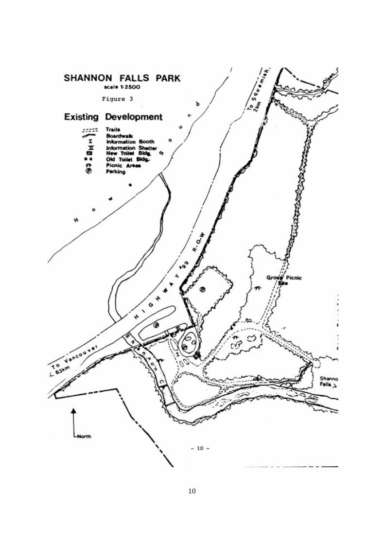
The majority of the existing park development (Figure 3) at Shannon Falls Park has been built during the period when Carling O'Keefe Breweries were the owners. This development included the trails, parking areas, landscaping, park furniture, primitive washroom facilities and a large building which housed water storage tanks. An outdoor logging museum created by local loggers was also part of the original development; however, with the exception of those items mentioned under cultural resources all equipment has been moved to Squamish. Since the donation of the park to the province, some additional development has taken place. The park has been provided with standard park signs, picnic tables, an information shelter and the parking area has been expanded to accommodate bus groups. Renovation to the water storage building is currently underway to provide modern washroom facilities.
10
11
F. Marketing Analysis 1) Existing Use Shannon Falls is used year-round by the touring public. Most visitors are highway travellers who stop to use the washroom facilities, have a picnic or walk around the park trails while admiring the falls. Others visit the park as part of a group for a picnic or as part of a bus tour. Summer is the most intensely used period with July usually the most popular month. Of the over 35,000 parties visits recorded for all of 1984, nearly 25% occurred in July. The market areas for Shannon Falls are somewhat specialized. Not only is the regional recreation market of the Highway #99 Corridor applicable but the international market for group tours is becoming a significant factor. A number of large American Corporations such as AT & T and the Ford Motor Company have held company picnics at Shannon Falls. These group picnics combine a trip up Howe Sound on the Royal Hudson with a catered picnic lunch in the upper picnic area of the park. A local "Loggers Sports" group often provide a scale-down version of a loggers sport show to interested parties. While the international market is essentially indeterminable, the regional market can be defined as the market for passive roadside recreational and tourism opportunities offered along highway #99 from Horseshoe Bay to Pemberton.
12
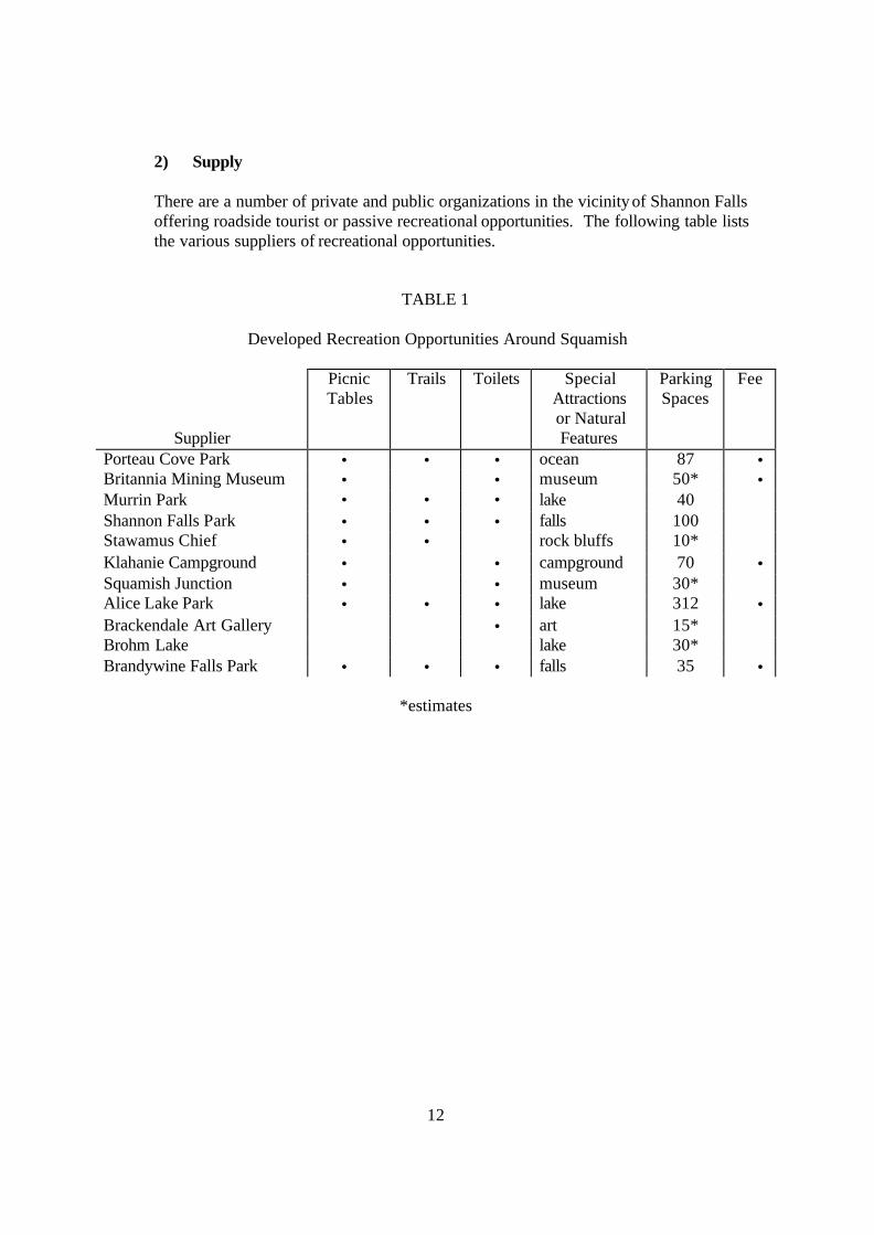
2) Supply
There are a number of private and public organizations in the vicinity of Shannon Falls offering roadside tourist or passive recreational opportunities. The following table lists the various suppliers of recreational opportunities.
TABLE 1
Developed Recreation Opportunities Around Squamish
Supplier
Picnic Tables
Trails Toilets Special Attractions or Natural Features
Parking Spaces
Fee
Porteau Cove Park • • • ocean 87 • Britannia Mining Museum • • museum 50* • Murrin Park • • • lake 40 Shannon Falls Park • • • falls 100 Stawamus Chief • • rock bluffs 10* Klahanie Campground • • campground 70 • Squamish Junction • • museum 30* Alice Lake Park • • • lake 312 • Brackendale Art Gallery • art 15* Brohm Lake lake 30* Brandywine Falls Park • • • falls 35 •
*estimates

13
3) Demand
Other than general recreation participation rates for the Lower Mainland, no detailed demand information exists. Some general indication of market direction within the local Provincial Park system can be seen through an analysis of historic use based upon the highway traffic volumes and park opportunities in the market area. From highway statistics, it appears that although traffic volumes have fluctuated from year to year, generally there has been little change over the past five years. As highway traffic volumes usually have a direct relationship to roadside park use, these figures suggest little change in demand for park opportunities. Unless there is an increase in traffic volume, park use levels will remain the same. Similarly, from records kept by Carling O'Keefe Breweries, it appears that demand at Shannon Falls as indicated by use is relatively constant at some 200,000 annual visits. 4) Conclusion It is apparent that new park opportunities could attract a greater intensity of park use despite the restrictions of having a limited number of potential visitors in the market area. Shannon Falls can improve its visitation levels by introducing new park opportunities that compliment and expand on the existing offerings.
14
G. Park Issues
Two issues dominate the master plan for Shannon Falls. The first issue is the extent of park development. Historically, visitors to the site have been afforded the opportunity to view the falls as well as attend logging shows, pay for trout fishing and admire a varied collection of logging and other equipment. These latter opportunities are not generally in keeping with Provincial Park development except in Fort Steele and Barkerville. The second issue concerns the need to include all of the Falls in the park to protect it's visual integrity. At present, the park boundary includes only the lower part of the Falls. The upper part, almost 80%, lies in the Soo Provincial Forest.

15
PART II: THE PLAN A. Purpose/Objectives
The general purpose of Shannon Falls Provincial Park is to conserve and protect the view of Shannon Falls and provide a variety of complimentary roadside day use recreational opportunities along the Highway #99 Corridor. Specific Objectives - to protect and present a special natural feature of the characteristic landscape, the
Rugged Pacific Ranges Regional Landscape. - to provide picnicking and rest stop opportunities for tours and groups. - to provide trail connections to adjacent recreation areas.
16
B. Zoning
To assist in the planning and management of the park, the entire area is included in a Development Zone. The Development Zone is a management designation which reflects the existing intensive level of park use and recreational development of this park.
C. Development Plan
A high level of facility development is required at Shannon Falls to accommodate the intense use it experiences in relation to its size. For the most part, the majority of the required facilities are in place. The following proposed development is intended to expand the diversity of park opportunities and/or simplify management requirements (Figure 4).
- Children's Creative Playground
A playground is a facility that can be easily accommodated on the site and would provide an attraction specific for family groups. The playground will contain a variety of climbing, swinging and sliding equipment. - Trail Connections Existing park trails will be expanded to link the Stawamus Chief and Klahanie campground recreational opportunities to Shannon Falls. - Landscaping Some ornamental landscaping will be removed to accommodate more picnic tables and reduce maintenance cost.

17
18
D. Management Policies
Based on specific objectives for the Park, policies for the management of Park resources and public use parallel normal Division policy.
a) Resources i) Land
Additions or deletions to the park boundary is not required at this time nor envisioned for the future. The preservation of the Falls is assured by the inherent undevelopable nature of it's sheer vertical walls. Adjacent land owners will be encouraged to provide trail linkages to the park with assistance given where possible and the Ministry of Forests will be encouraged to place Recreation Site status over the upper portion of the Falls.
ii) Water
Periodic stream bank modification during flooding periods will be monitored to assess the ongoing management requirements for all watercourses in the park.
iii) Vegetation
All natural vegetation will be left in a natural state except where a safety hazard is present. The Division Hazard Tree Policy and visual impact will govern any tree removal. Ornamental vegetation not proposed in the development plan for removal will be managed and maintained through standard horticultural methods.
iv) Fish and Wildlife
The Fish and Wildlife Branch will be requested to assist in determining and implementing improvements that could enhance the fish and wildlife resource of the park, eg. developing a fishery in Shannon Creek.
v) Visual Resources
Views of Shannon Falls will be given a very high priority when making any management decisions.
vi) Cultural and Historic Resources
All logging equipment with the exception of the steam donkey will be donated to the local museum and removed from the site.

19
b) Public Uses i) Recreation
The acceptable types of recreation in this park include viewing, picnicking and walking. Group picnicking will be continued and encouraged.
i) Special and other uses
The special use of the group picnic site for company picnics and logging shows will be addressed in a separate management proposal.
20
E. Marketing and Information Program Strategy
On the basis of the park resources and available recreational opportunities in and nearby the park, the concept for marketing Shannon Falls will be gradually shifted from a short term rest stop to a day use destination area. This transition will slowly become a reality as the proposed park development and trail linkages are established.
The day use recreational experience will be significantly enhanced by the development of the following interpretive themes and products completing the marketing concept for the park.
Logging Theme - the steam donkey, waterwheel and the natural logging features,
such as spring board notches, will be developed in the form of display and signs as a unified theme depicting how the park was hogged and the reaction of nature to such change.
Water Cycle Theme - The Waterfall, creek, wells, aquifer, abundant rain on the site and
the historic reputation of the falls for purity will be developed in the form of on-site signing explaining the watercycle.
Waterfall of - The Park will be included in an overall brochure theme Highway #99 highlighting the waterfalls along Highway #99 including Nairn
Falls and Brandywine Falls. Shannon Falls Marketing Strategy The marketing concept will be promoted through the additions to all relevant promotional maps, brochures, A.I.P. signs, and guide books when the opportunity arises, inclusion in a slide show and interpretation programs on the parks of the Garibaldi/Sunshine Coast District and through information to tour companies as part of group bus tours as well as the adjacent private campground. Park System Marketing Strategy With the large number of highway travelers stopping at Shannon Falls, the park plays a major role in marketing the park and outdoor recreational opportunities in its immediate vicinity and in the Howe Sound/Highway #99 Corridor. The existing on-site maps and signs promote the many other park opportunities in Garibaldi Park and along the highway and improved information on the local attractions such as the Stawamus Chief will be provided as the plan is implemented.
21
BIBLIOGRAPHY 1) Macaree, David and Marry. 103 Hikes in Southwestern British Columbia. British
Columbia Mountaineering Club and the Mountaineers, P.O. Box 122, Seattle, Washington, 1973.
2) Ministry of Lands, Parks and Housing, Province of British Columbia, Parks Data
Handbook, 1984. Unpublished report. 3) Parks Data Handbook (1983). February 1984. 4) Parks Data Handbook (1982). February 1983. 5) Parks Data Handbook (1981). February 1982. 6) Parks Data Handbook (1980). February 1981, 7) Parks Data Handbook (1979). February 1980. 8) Ministry of Lands, Parks and Housing, Parks and Outdoor Recreation Division, Lower
Mainland Region, Province of British Columbia. Shannon Falls Park Proposal. 1981. Unpublished report.
9) Ministry of Lands, Parks and Housing, Parks and Outdoor Recreation Division, Province of
British Columbia, Squamish-Lillooet Sub-Regional Systems Plan. 1982. Unpublished report.
10) Ministry of Transportation and Highways, Province of British Columbia, Summer Traffic
Volumes on Provincial Highways in British Columbia, 1979 to 1982. Unpublished report.