Embed Size (px)
Citation preview
City of Bellevue
Transportation Department
South Downtown I-405
Access Study Report
July, 2021
i
Acknowledgements
BELLEVUE CITY COUNCIL (May 31, 2021 Membership)
Lynne Robinson, Mayor John Stokes
Janice Zahn
Conrad Lee Jeremy Barksdale Jennifer Robertson
PROJECT STEERNG TEAM
Andrew Singelakis, Director, Transportation Department, COB
Mike Brennan, Director, Development Services, COB
Mac Cummins, Director, Community Development, COB
Lisa Hodgson, I-405 Program Administrator, WSDOT
CITY OF BELLEVUE STAFF
Paula Stevens, AICP, Assistant Director, Transportation Planning
Shuming Yan, PE, Project Manager
Marie Jensen, Public Involvement Manager
Dana Adell Molly Johnson Chris Long Elizabeth Stead
Monica Buck Ron Kessack Kevin McDonald Trisna Tanus
Steve Costa Emil King Eric Miller Cheryl Terry
Hu Dong Brian Landau Andreas Piller Sean Wellander
Gillian Hagstrom Doug Lane Mark Poch Nicholas Whipple
Chris Iverson Fred Liang Ming-Bang Shyu Lacey Jane Wolfe
Matthews Jackson Rick Logwood
TEAM MEMBERS FROM WSDOT TEAM MEMBERS FROM SOUND TRANSIT
Barrett Hanson, P.E., Design Manager Andrea Tull, PMP, Senior Project Manager
Karl Westby, PhD, Traffic Manager
David Gerla, PE, Design Engineer
COMMUNITY ENGAGEMENT CONSULTANTS
Laura LaBissoniere Miller, PRR Inc. Nancy Thai, PRR Inc.
STAKEHOLDERS
Bellecrest Neighborhood Association Surrey Downs Community Club
Downtown Bellevue Resident Association Wilburton Community Association
Representatives of properties within the study area Woodridge Neighborhood Association
COMMUNITY ORGANIZATIONS
Bellevue Downtown Association Downtown for People/Complete Streets Bellevue
Bellevue Chamber of Commerce HopeLink Eastside Easy Rider Collaborative
Eastside Transportation Association
Jared Nieuwenhuis, Deputy Mayor
ii
Table of Contents
Executive Summary ................................................................................................................. 2
Introduction .............................................................................................................................. 4
Study Area ............................................................................................................................. 4
Project Purpose and Need ...................................................................................................... 5
Planning Context .................................................................................................................... 6
Study Guiding Principles/Objectives ...................................................................................... 9
Methodology............................................................................................................................11
Existing Conditions ................................................................................................................13
Roadway Network .................................................................................................................13
Non-Motorized Travel ............................................................................................................14
Arterial Vehicle Volumes .......................................................................................................14
Traffic Operations at Intersections .........................................................................................14
Crash Data ............................................................................................................................17
2035 Baseline Conditions .......................................................................................................19
2035 Land Use Assumptions .................................................................................................19
2035 Baseline Network Assumptions ....................................................................................21
2035 Baseline Traffic Forecasts ............................................................................................22
2035 No Build/Baseline Traffic Conditions .............................................................................25
Alternatives Development and Analysis ...............................................................................26
Stakeholder and Community Engagement ............................................................................26
Alternative Evaluation Criteria ...............................................................................................26
Development of Alternatives ..................................................................................................27
Alternative Analysis ...............................................................................................................32
Tier 1 Fatal Flaw Screening ...............................................................................................32
Tier 2 Alternatives Conceptual Design and Analysis ..........................................................36
NE 2nd Street Extension – Alternative Alignments .........................................................36
SE 6th Street Extension – Lane Configuration ................................................................38
SE 6th Street Extension – Nonmotorized Facilities .........................................................39
Lake Hills Connector Southbound On-Ramp – Nonmotorized Facilities..........................41
Tier 2 Alternatives Evaluation.............................................................................................41
Lake Hills Connector Southbound On-Ramp ..................................................................42
SE 6th Street Extension with Southbound On-Ramp ......................................................44
SE 6th Street Extension with Direct Access .....................................................................46
iii
NE 2nd Street Extension ..................................................................................................50
No Build..........................................................................................................................52
Traffic Analysis for Tier 2 Alternatives Evaluation ...............................................................53
I-405 Access Capacity Added .........................................................................................53
2035 Traffic Forecasts for Alternatives ...............................................................................53
2035 Alternatives Traffic Analysis ...................................................................................59
Alternative Analysis Summary ...............................................................................................61
Community Input ...................................................................................................................63
Recommended Alternative .....................................................................................................65
Next Steps ...............................................................................................................................67
iv
Figures
Figure 1 Study Area and Traffic Analysis Area ....................................................................... 5 Figure 2 Decision-Making Process ........................................................................................11 Figure 3 Project Analysis Process .........................................................................................12 Figure 4 2018 PM Peak Hour Traffic Volumes .......................................................................15 Figure 5 Existing Turning Movement Volumes at Study Intersections....................................16 Figure 6 Non-residential and Housing Unit Growth Distribution .............................................21 Figure 7 2035 Baseline PM Peak Hour Traffic Volumes ........................................................22 Figure 8 2035 Baseline Turning Movement Volumes at Study Intersections..........................24 Figure 9 Screening Process ......................................................................................................32 Figure 10 Concept Design for NE 2nd Street North Alignment ..............................................37 Figure 11 Concept Design for NE 2nd Street South Alignment ..............................................38 Figure 12 Concept Design for SE 6th Street Four Lane Roadway ........................................39 Figure 13 Concept Design for SE 6th Street Two Lane Roadway ........................................39 Figure 14 Concept Design for SE 6th Street Multipurpose Path to Lake Hills Connector ......40 Figure 15 Concept Design for SE 6th Street Multipurpose Path to SE 5th Street ..................40 Figure 16 Concept Design for Lake Hills Connector with Multipurpose Path ........................41 Figure 17 Concept Design for Lake Hills Connector Southbound On-Ramp Alternative .......42 Figure 18 Concept Design for SE 6th Street Extension with Southbound On-Ramp
Alternative 44 Figure 19 Concept Design for SE 6th Street Extension Direct Access Alternative................47 Figure 20 Concept Design for the NE 2nd Street Extension Alternative ................................50 Figure 21 I-405 Access Capacity .........................................................................................53 Figure 22 Additional Intersection Improvements ..................................................................54 Figure 23 Modification of Lane Configuration for Lake Hills Connector Southbound On-Ramp
Alternative 54 Figure 24 2035 Lake Hills Connector Southbound On-Ramp Alternative Turning Movement
Volumes at Study Intersections .................................................................................................55 Figure 25 2035 SE 6th Street Extension Inside Access Alternative Turning Movement
Volumes at Study Intersections .................................................................................................56 Figure 26 2035 SE 6th Street Extension and Southbound On-Ramp Alternative Turning
Movement Volumes at Study Intersections ...............................................................................57 Figure 27 2035 NE 2nd Street Extension Alternative Turning Movement Volumes at Study
Intersections 58 Figure 28 Citywide Travel Time Savings ..............................................................................59 Figure 29 Overall PM Peak Hour Vehicle Delay Reduction Compared to 2035 No Action ...61 Figure 30 Improvements Included in Recommended Alternative .........................................66

i
Tables
Table 1 2018 PM Peak Hour Traffic Volumes and Delay for Study Intersections ..................17 Table 2 2018 Citywide Crash Data .......................................................................................17 Table 3 Crash Data, Average Traffic Volumes and Crash Rates for North-South Corridors .18 Table 4 Crash Data, Average Traffic Volumes and Crash Rates for East-West Corridors ....18 Table 5 Crash Data, Average Traffic Volumes and Crash Rates for Ramp Terminals ..........18 Table 6 2019 Existing Land Uses by Mobility Management Area .........................................19 Table 7 2035 Projected Land Uses by Mobility Management Area .......................................20 Table 8 Projected 2019 to 2035 Land Use Changes ............................................................20 Table 9 Downtown Bellevue Trips by Purpose .....................................................................23 Table 10 Daily Downtown Tour* Mode Share .........................................................................23 Table 11 2035 Baseline PM Peak Hour Volumes and Delay for Study Intersections ..............25 Table 12 South Downtown I-405 Access Alternative Tier 1 Fatal Flaw Screening ...................35 Table 13 Major Construction Quantities and Impacts for Lake Hills Connector Southbound On-
Ramp Alternative ......................................................................................................................43 Table 14 Major Construction Quantities and Impacts for SE 6th Street Extension with
Southbound On-Ramp Alternative.............................................................................................46 Table 15 Major Construction Quantities and Impacts for SE 6th Street Extension with Direct
Access Alternative ....................................................................................................................50 Table 16 Major Construction Quantities and Impacts for NE 2nd Street Extension Alternative 52 Table 17 Comparison of 2035 PM Peak Hour Volumes and Delay for Study Intersections .......60 Table 18 Alternative Evaluation Summary ...............................................................................62
South Downtown I-405 Access Study Report 2
Executive Summary Bellevue is entering a new phase of rapid growth, most of which is expected to occur in
Downtown and the nearby commercial areas of Wilburton and BelRed. Multimodal
transportation infrastructure improvements are needed to support this anticipated growth, both
on local facilities and on facilities that serve longer distance trips via state routes and interstate
routes.
The I-405 Corridor Program Master Plan approved in 2002 anticipated the need for additional
access points through Bellevue, including a new half-diamond interchange in the vicinity of NE
2nd Street to improve vehicle access to/from the south (I-405 Project #108). In late 2019,
Council determined that further study was needed to evaluate all plausible options before
identifying an alternative(s) that would best meet the city’s transportation needs and support
anticipated growth. More immediately, private sector redevelopment along 114th Avenue and
the East Main Transit Oriented Development (TOD) land use code amendment (LUCA), as well
as the development concepts proposed for the Wilburton area, have created a pressing need for
the city to conduct a study and identify a preferred option.
Following a year of analysis and public engagement, the study confirmed the need for additional
access to/from south Downtown and I-405. In April 2020, the City Council unanimously
supported the staff recommendation to advance a Lake Hills Connector southbound on-ramp to
I-405 as the alternative that best meets the city’s transportation needs in the south Downtown
area. The Lake Hills Connector southbound on-ramp concept adds vehicle access to
southbound I-405 with minimal property and environmental impacts at a reasonable cost
(estimated at $150 million in 2030 dollars) as compared to the other alternatives studied. The
Council recommended alternative also aligns with city land use and urban design policies and
allows the East Main TOD land use code amendment process to continue.
Accompanying the Lake Hills Connector alternative, several intersection improvements along
116th Avenue NE and non-motorized system improvements along SE 8th Street were identified
as important elements of the transportation package. The map on the following page depicts the
improvements included in the recommended alternative.
The study was conducted by the city, in partnership with the Washington State Department of
Transportation (WSDOT). To the extent possible, the study followed the Planning Environmental
Linkage (PEL) protocol, a Federal Highway Administration initiative to accelerate project
delivery. PEL is a collaborative and integrated approach to transportation decision-making that
1) considers environmental, community, and economic goals early in the transportation planning
process, and 2) uses the information, analysis, and products developed during planning to
inform the environmental review process that will be carried out by WSDOT when design and/or
construction funding is available.
The information developed during this study, including public and stakeholder engagement,
project purpose and needs, goal statements, and alternatives analysis provide the analytical
foundation for including the study recommendation in the city’s Transportation Improvement
Program, ensuring its eligibility for funding. Further, identifying an alternative(s) allows the
project to begin the environmental review and access revision request processes when funding
is secured by WSDOT. Additional environmental work and Federal Highway Administration
(FHWA) approvals are required before formally selecting a preferred alternative.
South Downtown I-405 Access Study Report 3
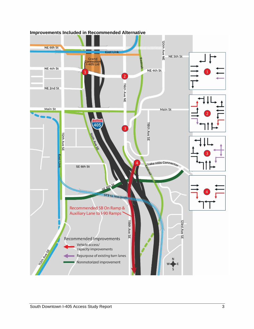
Improvements Included in Recommended Alternative
South Downtown I-405 Access Study Report 4
Introduction The I-405 Corridor Program Master Plan approved in 2002 includes a new half-diamond
interchange at NE 2nd Street (hereafter referred to as south Downtown I-405 Access) to
improve vehicle access to/from the south. This new interchange would complement the half-
diamond interchange to/from the north at NE 10th Street.
As part of the Renton to Bellevue Widening and Express Toll Lanes project (ETL), the Main
Street bridge over I-405 is being replaced with a longer span to accommodate the new express
toll lanes. In 2015 and 2016, WSDOT, in collaboration with the City, performed an analysis to
ensure that the new Main Street bridge would be forward compatible and would not preclude
potential options to implement the south Downtown I-405 Access. The 2015/2016 analysis
identified several potential locations/options where a south Downtown access connection could
be accommodated by the new Main Street bridge. Those options were carried forward for
further evaluation in a future study.
Aligned with the I-405 Master Plan, the City of Bellevue’s Comprehensive Plan includes a new I-
405 access at NE 2nd Street. The Comprehensive Plan provides consistency through the years
yet is dynamic and may be amended annually as circumstances change. Because the
2015/2016 study identified a number of options to consider in addition to or in lieu of a NE 2nd
Street location, a new access at NE 2nd Street is considered a placeholder pending further
study.
More recently, private sector redevelopment along 114th Avenue NE, the East Main transit-
oriented development (TOD) land use code amendment (LUCA), as well as development
concepts proposed for the Wilburton commercial area, have created a pressing need for the city
to identify transportation improvements in the south Downtown area. The identification of an
alternative(s) enables the City to set clear expectations for property owners/developers
regarding right-of-way needs and site access options and restrictions, thereby minimizing the
potential incompatibility between land use and transportation decisions.
The South Downtown I-405 Access Study was to kick off following a briefing to the Bellevue City Council on April 20, 2020. The city attorney’s office determined that the meeting could not be conducted as it did not satisfy the “necessary and routine” requirements for City Council meetings as per the Governor’s Emergency Proclamation issued in response to the COVID-19 pandemic. The decision was made to initiate the study and return to Council for a mid-point review. A final Council presentation and alternative recommendation would occur before concluding the study.
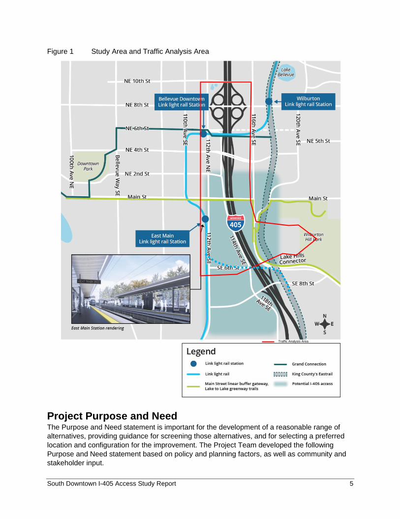
Study Area Figure 1 shows the study area and the traffic analysis area. The study area is bounded by NE 4th Street and SE 8th Street and defines the area within which physical project improvements are expected to occur. The traffic analysis area includes all major intersections and ramp terminals bounded by NE 8th Street in the north, SE 8th Street in the south, 112th Avenue NE/SE to the west, and 116th Avenue NE/SE to the east.
South Downtown I-405 Access Study Report 5
Figure 1 Study Area and Traffic Analysis Area
Project Purpose and Need The Purpose and Need statement is important for the development of a reasonable range of
alternatives, providing guidance for screening those alternatives, and for selecting a preferred
location and configuration for the improvement. The Project Team developed the following
Purpose and Need statement based on policy and planning factors, as well as community and
stakeholder input.
Traffic Analysis Area
South Downtown I-405 Access Study Report 6
Purpose
The purpose of this project is to improve south Downtown Bellevue vehicle access to/from I-405
for better regional connectivity. Additionally, the project will improve circulation with the local
street network for motorized and non-motorized traffic, while minimizing community and
environmental impacts. The project should support the City of Bellevue urban design, land use,
economic development, and transportation policies, improve community connectivity and be
consistent with the I-405 Master Plan.
Need
By 2035, it is estimated that approximately 22 million square feet of commercial building space
and 9000 dwelling units will be added to the study area and vicinity. The existing interchanges
cannot meet this anticipated demand. To relieve congestion, accommodate growth and improve
safety, additional interchange capacity in the south Downtown area is needed. This need is also
identified in the I-405 Master Plan and is intended to complement the half interchange at NE
10th Street and the NE 6th Street extension.
Planning Context Many planning efforts have been completed within the study area. The relevant plans are
described below.
I-405 Corridor Master Plan
In 2002, after a three-year study of the area and extensive work with stakeholders up and down
the I-405 corridor, WSDOT adopted an environmental impact statement, which became the
basis of the I-405 Master Plan. The Master Plan contains a set of long-term improvements
designed to get more people moving through the corridor, to be accomplished with the
incremental completion of more than 150 individual projects. One of those projects is a new I-
405 freeway interchange at NE 2nd Street in Downtown Bellevue, envisioned as a half diamond
interchange to/from the south. See page 41 of the I-405 Master Plan Report (2002) for the
project description.
Puget Sound Regional Council Transportation 2040
Transportation 2040 is the long-range multimodal transportation plan for central Puget Sound,
including the counties of Pierce, King, Snohomish, and Kitsap. It lays out comprehensive
transportation investments and strategies to accommodate an expected 1.5 million additional
people and 1.2 million new jobs by 2040. The Transportation 2040 Regional Capacity Project
List includes a half interchange at NE 2nd Street (pending further study), echoing the need
identified in the I-405 Master Plan.
Bellevue’s Comprehensive Plan
The Comprehensive Plan is the Bellevue City Council-adopted policy document. It is a dynamic
document which provides policy guidance for transportation, land use, parks, recreation, and
open space. The current Comprehensive Plan was adopted in 2015, and has been amended
twice, once in 2018 for Downtown policies and another in 2019 for Southwest Bellevue (East
Main TOD) policies.
South Downtown I-405 Access Study Report 7
Bellevue’s Comprehensive Transportation Project List (2015)
The Comprehensive Transportation Project List aggregates all types of transportation system
projects that have been vetted through a public process. The following projects relate to
improving Downtown access to I-405 pending further study:
CTPL-67. Add new I-405 access at NE 2nd Street via collector-distributor lanes from and to the
south.
CTPL-75. Extend NE 2nd Street from 112th Avenue NE across I-405 to 116th Avenue NE,
including intersection improvements at 112th Avenue NE and 116th Avenue NE.
CTPL-76. Widen NE 2nd Street between Bellevue Way and 112th Avenue NE from 3 or 4 to 5
lanes.
In addition, the Pedestrian and Bicycle Transportation Plan (2009) identifies projects that
support a connected and safe non-motorized transportation network. Lastly, Multimodal Level-
of-Service Metrics, Standards and Guidelines (Transportation Commission 2017) provide both
regulatory and qualitative expectations for components of the non-motorized transportation
system.
Other Transportation Projects in the Vicinity
Several important transportation facilities are being implemented or planned in the vicinity to
provide additional multimodal capacity to serve the City. These include:
• I-405 Renton to Bellevue Widening and Express Toll Lanes
This project, currently under construction, will add one new lane in each direction to create a
two-lane express toll lane system between SR 167 in Renton and Northeast 6th Street in
Bellevue. It also includes:
- A new southbound auxiliary lane in the I-90 to 112th Avenue Southeast vicinity
- Improvements to the I-405/I-90 Interchange by adding a new lane to the I-405
southbound to I-90 eastbound ramp.
• I-405 Bus Rapid Transit
Funded by the voter approved Sound Transit 3 package, I-405 Bus Rapid Transit (BRT) will
connect communities along I-405 and SR 518 between Lynnwood and Burien. With buses
running as often as every 10 minutes, this new service will connect to Link light rail at
Lynnwood, Bellevue, and Tukwila as well as to other transit service provided by Sound Transit
and King County Metro. It builds upon the Washington State Department of Transportation's I-
405 Master Plan with roadway improvements for faster travel. The project is in final design and
construction is expected to start in 2023. The new service is expected to open in 2025.
• Sound Transit Light Rail Projects
Two light rail lines, one under construction and the other in the planning stage, cross the study
area. The East Link, currently under construction, extends 14 miles from downtown Seattle,
through downtown Bellevue, crosses I-405 near NE 6th Street and connects to the Overlake
area in Redmond. The South Kirkland to Issaquah Light Rail via Bellevue is in the early planning
South Downtown I-405 Access Study Report 8
stage. It is envisioned to share a portion of the East Link rail tracks through Wilburton and
Downtown Bellevue. It then splits out just south of the East Main Station and crosses I-405 in
the vicinity of SE 8th Street. This project is expected to be completed in 2041.
• Eastrail
The Eastrail will be a 42-mile trail that will connect Renton, Bellevue, Kirkland, Woodinville,
Snohomish, and Redmond with new opportunities for non-motorized recreation and
transportation. Currently 13 miles of the Eastrail are open. A 2.5-mile paved section and a new
crossing over I-405 near downtown Bellevue at the site of the former Wilburton rail bridge will be
constructed by WSDOT as part of the I-405 Bellevue to Renton Widening and Express Toll
Lanes Project.
• Grand Connection
The Grand Connection is a planned facility to create landmark, pedestrian-focused experiences
through the heart of downtown Bellevue. With a length of over 1.5 miles, the Grand Connection
begins at the waterfront of Lake Washington at Meydenbauer Bay Park, and winds through Old
Bellevue and Bellevue Downtown Park. It continues through Bellevue’s retail and civic-focused
parts of downtown, across I-405 and ultimately connects with Eastrail. Several segments of the
Grand Connection in Downtown are under construction by private developers. The segment of
the Grand Connection east to Wilburton and the Eastrail is currently in the planning stage.
• Lake to Lake Trail
The Lake to Lake Trail connects nine parks across Bellevue. From east to west, the trail starts
at Weowna Park next to Lake Sammamish. From there, the trail heads to the Lake Hills
Greenbelt via SE 24th Street or SE 16th Street. After meandering through the Lake Hills
Greenbelt, the trail leads to Main Street then heads west to the Downtown Park and ends at
Meydenbauer Beach Park on Lake Washington.
• NE 6th Street Extension
Likely through a partnership between the City and WSDOT, this project will extend NE 6th Street
from the middle of I-405 to either 116th Avenue NE or 120th Avenue NE. It will provide access to
the express toll lanes from Wilburton.
South Downtown I-405 Access Study Report 9
Study Guiding Principles/Objectives Building on the project Purpose and Need Statement and input from the community outreach
efforts, the study team identified a set of study guiding principles and objectives to establish the
desired outcomes and processes for the study.
• Align with and support adopted plans and policies
This guiding principle is to ensure the identified alternative(s) are in alignment with and in
support of:
- Federal interstate access policies as reflected in the I-405 Master Plan.
- The City’s Comprehensive Plan and policies including the elements of transportation,
land use, urban design, and environmental stewardship.
• Reduce congestion and improve system performance
This guiding principle is to ensure the identified alternative(s) achieves the goal of improving
overall performance of the transportation system including I-405 and local multimodal
transportation networks. The performance measures used in the assessment focus on travel
time and delay. It includes the following objectives:
- Reduce overall travel time as measured by daily vehicle hours of travel time reduced.
- Improve intersection operations within the study area.
- Improve travel time from Downtown to major destinations such as Bellevue College and
Mercer Island.
• Encourage safe multimodal connections
This guiding principle is to ensure the identified alternative(s) achieve the goal of improving
access to I-405 and at the same time do not compromise the safety and connectivity of the local
multimodal transportation networks. The performance measures used in the assessment focus
on access and safety. The objectives are:
- Improve travel safety for all modes.
- Avoid creating vehicle/non-motorized movement conflicts that impede access to the
major multimodal hubs such as East Main Light Rail Station, Bellevue Transit Center,
and the Lake to Lake Trail along Main Street.
• Support economic development and minimize property impacts
This guiding principle ensures the alternative evaluation considers full and partial impacts to
adjacent property in terms of right-of-way needs that may reduce the property’s development
potential. The performance measures used in the assessment focus on property/economic
impact.
• Manage cost and minimize environmental impacts
This guiding principle sets the goal to minimize cost and impact by accounting for all costs in the
analysis, including construction and mitigation.
South Downtown I-405 Access Study Report 10
• Engage stakeholders and public
The guiding principle ensures that community engagement, including stakeholders, interested
groups, and the general public, is an integral part of the study process, ensuring that the
preferred alternative considers community needs and preferences. Early and continuous
community engagement brings diverse viewpoints and values into the decision-making process.
This process enables the city and partner agencies to make decisions through collaborative
efforts and builds mutual understanding and trust between the City and the public it serves.
Community engagement during the study included the following:
- Included WSDOT as a partner in the study
- Hosted four stakeholder meetings at key stages of the study process to solicit input and
feedback. Stakeholders included representatives from the following groups:
o Property/business owners who may be directly impacted
o Downtown Bellevue Residents Association
o Surrey Downs Community Club
o Wilburton Community Association
o Bellecrest Neighborhood Association
o Woodridge Community Association
- Conducted two online open houses to gather public input
- Provided information briefings to interest groups as requested
For more details, please see City of Bellevue/South Downtown I-405 Access Study Community
Engagement Report.
South Downtown I-405 Access Study Report 11
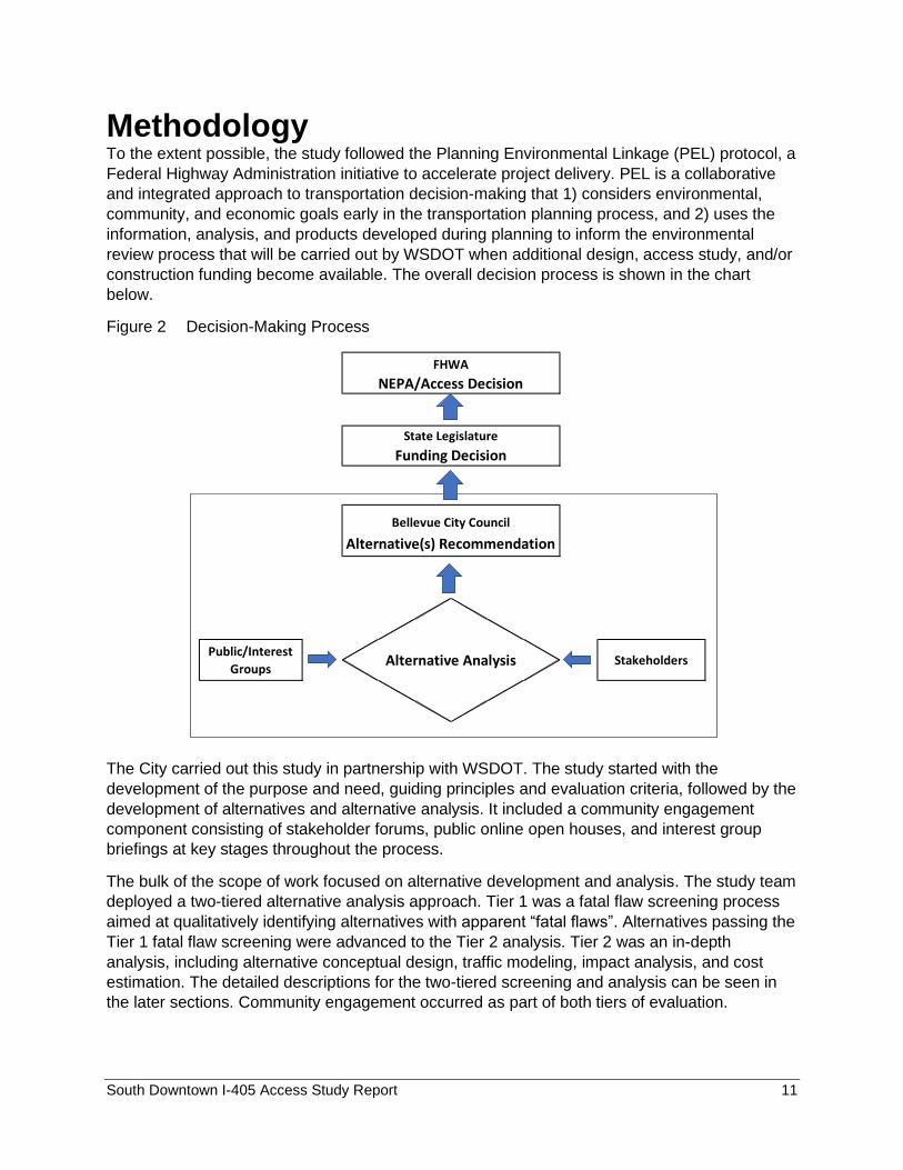
Methodology To the extent possible, the study followed the Planning Environmental Linkage (PEL) protocol, a
Federal Highway Administration initiative to accelerate project delivery. PEL is a collaborative
and integrated approach to transportation decision-making that 1) considers environmental,
community, and economic goals early in the transportation planning process, and 2) uses the
information, analysis, and products developed during planning to inform the environmental
review process that will be carried out by WSDOT when additional design, access study, and/or
construction funding become available. The overall decision process is shown in the chart
below.
Figure 2 Decision-Making Process
The City carried out this study in partnership with WSDOT. The study started with the
development of the purpose and need, guiding principles and evaluation criteria, followed by the
development of alternatives and alternative analysis. It included a community engagement
component consisting of stakeholder forums, public online open houses, and interest group
briefings at key stages throughout the process.
The bulk of the scope of work focused on alternative development and analysis. The study team
deployed a two-tiered alternative analysis approach. Tier 1 was a fatal flaw screening process
aimed at qualitatively identifying alternatives with apparent “fatal flaws”. Alternatives passing the
Tier 1 fatal flaw screening were advanced to the Tier 2 analysis. Tier 2 was an in-depth
analysis, including alternative conceptual design, traffic modeling, impact analysis, and cost
estimation. The detailed descriptions for the two-tiered screening and analysis can be seen in
the later sections. Community engagement occurred as part of both tiers of evaluation.
Public/Interest
GroupsAlternative Analysis Stakeholders
FHWA
NEPA/Access Decision
State Legislature
Funding Decision
Bellevue City Council
Alternative(s) Recommendation
South Downtown I-405 Access Study Report 12
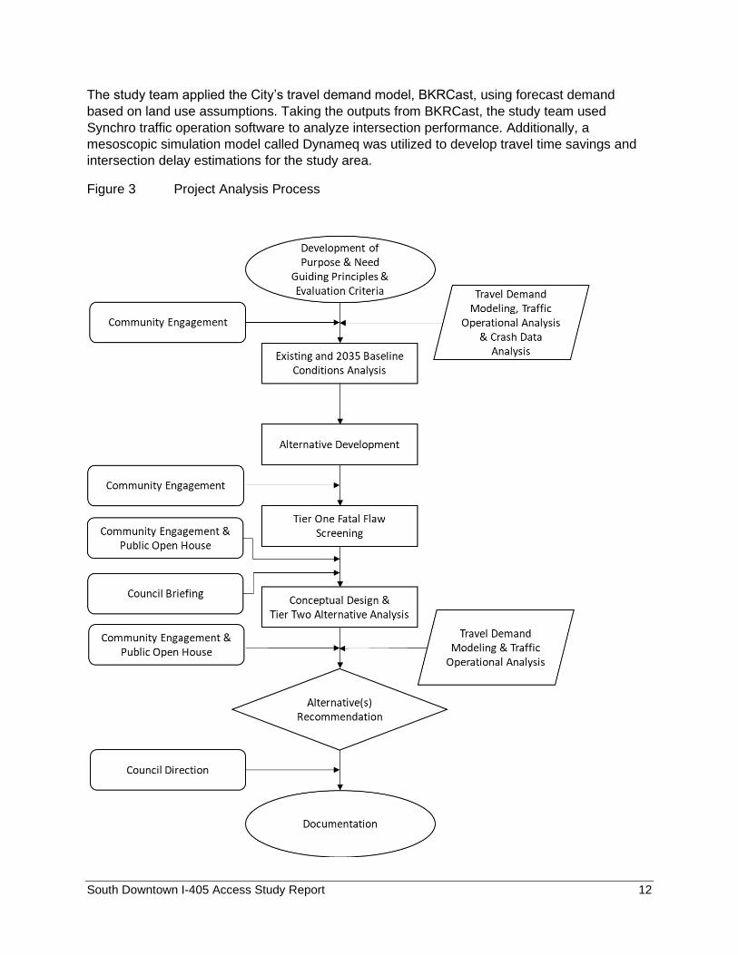
The study team applied the City’s travel demand model, BKRCast, using forecast demand
based on land use assumptions. Taking the outputs from BKRCast, the study team used
Synchro traffic operation software to analyze intersection performance. Additionally, a
mesoscopic simulation model called Dynameq was utilized to develop travel time savings and
intersection delay estimations for the study area.
Figure 3 Project Analysis Process
South Downtown I-405 Access Study Report 13
Existing Conditions This section describes the existing roadway network, interchange issues and deficiencies, non-motorized travel, transit service, vehicle volumes, traffic operations, and historic crash data.
Roadway Network Freeway System Downtown Bellevue is served by three major freeway systems. I-405 is the north-south travel
corridor, forming the east boundary of Downtown. It provides immediate access for Downtown
traffic through interchanges at NE 8th Street, NE 6th Street and NE 4th Street. In addition, the
interchange at SE 8th Street provides a viable option to access Downtown. To relieve heavy
peak hour congestion on I-405, the north section of the express toll lane (ETL) project that
added two-lanes in each direction between Bellevue and Lynwood was opened in 2015. The
south section between Bellevue and Renton is under construction with a planned opening in
2024. The NE 6th Street interchange provides direct access to the ETL lanes to the north and
current HOV lane (future ETL lanes) to the south.
Interstate 90 and SR 520 are two east-west travel corridors connecting Bellevue with Seattle and other cities on the eastside. Both freeways provide additional access to Downtown Bellevue from the south (via the Bellevue Way interchange) and the north (via interchanges at Bellevue Way and 108th Avenue NE). East-West Arterials Downtown Bellevue is connected with the Wilburton area (east of I-405) through I-405 overcrossings at NE 12th Street, NE 10th Street, NE 8th Street, NE 4th Street, and Main Street. NE 10th Street and Main Street are classified as minor arterials and the others are classified as major arterials. Ramp terminals at NE 8th Street and NE 4th Street provide full access to I-405 in both directions. The ramp terminal at NE 6th Street provides exclusive access to I-405 north for ETL traffic, and I-405 south for HOV (2+) traffic. After completion of the ETL project between Bellevue and Renton, access from NE 6th Street will become ETL traffic only. NE 12th Street and Main Street cross I-405 but provide no vehicle access to the freeway. SE 8th Street, connecting South Bellevue and Wilburton area, serves as another freeway access in close proximity to the south section of Downtown. North-South Arterials Bellevue Way and 112th Avenue NE, are classified as major arterials, and run parallel to I-405 which connects to SR 520 to the north. Both arterials pass through the entire Downtown area. After SE 8th Street, 112th Avenue SE bends to the southwest and terminates at the intersection of Bellevue Way, which runs farther south to I-90. 114th Avenue NE/SE runs immediately to the west of I-405. It provides access to businesses and services at the east boundary of Downtown. The segment to the north of SE 8th Street is classified as a minor arterial. South of SE 8th Street, it continues as 118th Avenue SE and is classified as a collector road, serving as the only roadway west of I-405 connecting Downtown Bellevue to Factoria.

South Downtown I-405 Access Study Report 14
Interchange Issues and Deficiencies During the PM peak period, traffic between Downtown Bellevue and I-405 experiences
significant congestion and queuing, exacerbated by closely spaced intersections. High traffic
volumes plus freeway congestion result in travel delays and queuing at numerous locations
along NE 8th Street, NE 4th Street and 112th Avenue NE.
Closely spaced ramp terminals on the NE 4th Street overcrossing also create operational
inefficiencies. During peak periods, vehicle queues often block upstream, adjacent intersections
in both directions due to limited storage space on the bridge.
The existing interchanges in the area are largely built out. All the general purpose on-ramps
have ramp meters in place.
Non-Motorized Travel I-405 is a major barrier to non-motorized travel between Downtown and the Wilburton area.
There are five crossings within Downtown. Three crossings are at NE 12th Street, NE 10th Street
and Main Street. Each crossing has raised sidewalks on both sides. The NE 12th Street crossing
includes a multi-purpose path along the north side. No bike lanes are available to cross the
freeway on NE 10th Street or Main Street.
Although nonmotorized paths exist on the NE 4th Street and NE 8th Street connecting the
Downtown core and the Wilburton commercial zone, to cross the freeway, pedestrians and
bicyclists must cross a number of high-volume intersections and oversaturated freeway ramps
that are designed with wide turning radii. This creates obstacles and safety issues for people
walking and biking.
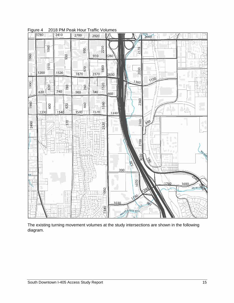
Arterial Vehicle Volumes In 2018, the segment of I-405 south of Downtown Bellevue carried approximately 169,000
vehicles per weekday, and 178,000 vehicles to the north of Downtown. For the City’s arterials,
the 2018 PM peak hour traffic counts were analyzed and can be seen in Figure 4.
Traffic Operations at Intersections Intersection operation analyses focused on the overall intersection average delay per vehicle
based on the methodology contained in the Highway Capacity Manual (HCM). The traffic
analysis software Synchro was used for calculating intersection delays. Intersection geometry,
signal cycle length, effective green time, phasing, arterial signal coordination, and traffic
volumes were important inputs into the analyses. It accounted for control delay and queue
delay.
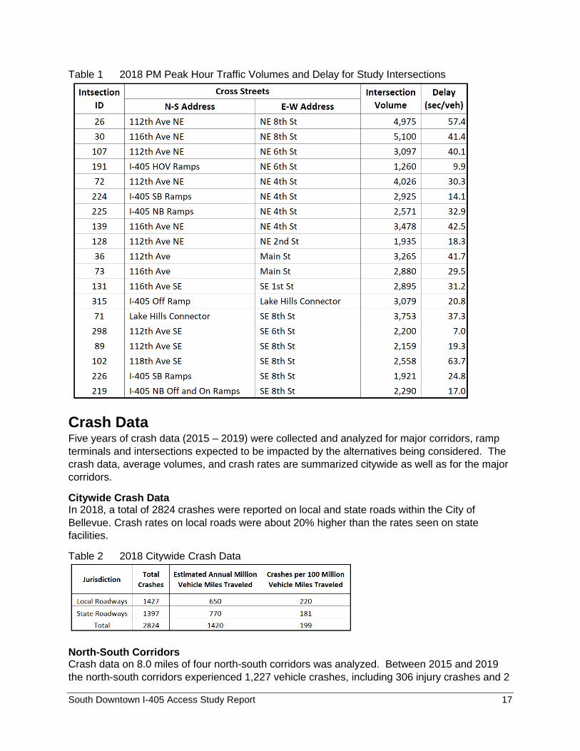
During the 2018 PM peak hour, the 118th Avenue SE/SE 8th Street intersection experiences
81.2 seconds of delay per vehicle. The 112th Avenue NE/NE 8th Street intersection operates at
the average of 61.1 seconds of delay. The rest of the intersections operate at less delays. The
list of study intersection and the results of the existing PM peak hour intersection analysis are
summarized in Table 2. The total observed PM peak hour volumes are also provided.
South Downtown I-405 Access Study Report 15
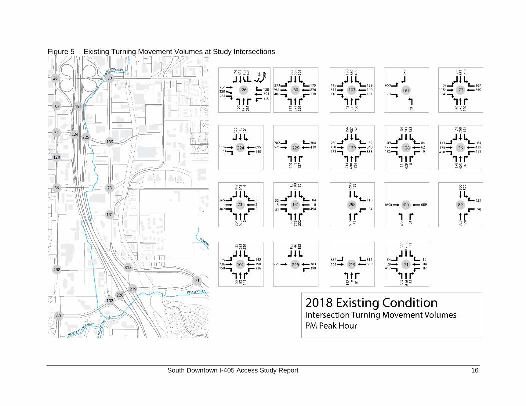
Figure 4 2018 PM Peak Hour Traffic Volumes
The existing turning movement volumes at the study intersections are shown in the following
diagram.
South Downtown I-405 Access Study Report 16
Figure 5 Existing Turning Movement Volumes at Study Intersections
South Downtown I-405 Access Study Report 17
Table 1 2018 PM Peak Hour Traffic Volumes and Delay for Study Intersections
Crash Data Five years of crash data (2015 – 2019) were collected and analyzed for major corridors, ramp
terminals and intersections expected to be impacted by the alternatives being considered. The
crash data, average volumes, and crash rates are summarized citywide as well as for the major
corridors.
Citywide Crash Data In 2018, a total of 2824 crashes were reported on local and state roads within the City of
Bellevue. Crash rates on local roads were about 20% higher than the rates seen on state
facilities.
Table 2 2018 Citywide Crash Data
North-South Corridors Crash data on 8.0 miles of four north-south corridors was analyzed. Between 2015 and 2019
the north-south corridors experienced 1,227 vehicle crashes, including 306 injury crashes and 2
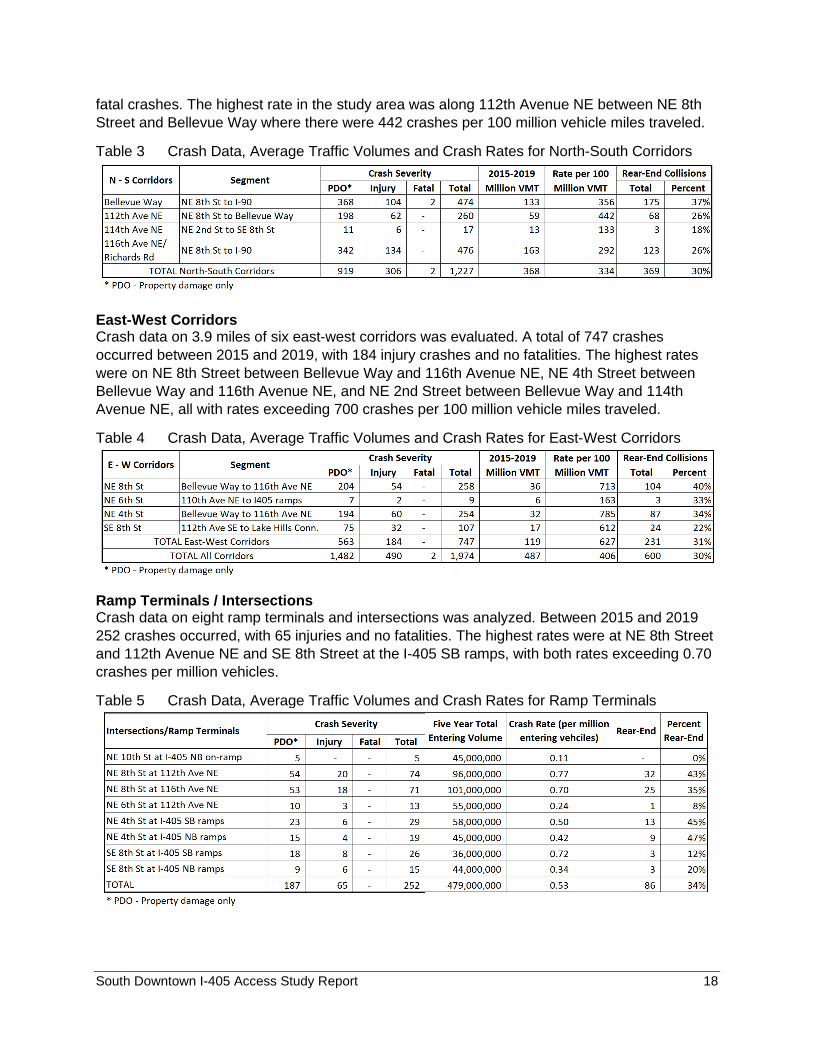
South Downtown I-405 Access Study Report 18
fatal crashes. The highest rate in the study area was along 112th Avenue NE between NE 8th
Street and Bellevue Way where there were 442 crashes per 100 million vehicle miles traveled.
Table 3 Crash Data, Average Traffic Volumes and Crash Rates for North-South Corridors
East-West Corridors Crash data on 3.9 miles of six east-west corridors was evaluated. A total of 747 crashes
occurred between 2015 and 2019, with 184 injury crashes and no fatalities. The highest rates
were on NE 8th Street between Bellevue Way and 116th Avenue NE, NE 4th Street between
Bellevue Way and 116th Avenue NE, and NE 2nd Street between Bellevue Way and 114th
Avenue NE, all with rates exceeding 700 crashes per 100 million vehicle miles traveled.
Table 4 Crash Data, Average Traffic Volumes and Crash Rates for East-West Corridors
Ramp Terminals / Intersections Crash data on eight ramp terminals and intersections was analyzed. Between 2015 and 2019
252 crashes occurred, with 65 injuries and no fatalities. The highest rates were at NE 8th Street
and 112th Avenue NE and SE 8th Street at the I-405 SB ramps, with both rates exceeding 0.70
crashes per million vehicles.
Table 5 Crash Data, Average Traffic Volumes and Crash Rates for Ramp Terminals
South Downtown I-405 Access Study Report 19
2035 Baseline Conditions This section describes the 2035 future land use development, planned transportation system
improvements, and forecast PM peak hour traffic volumes and operations.
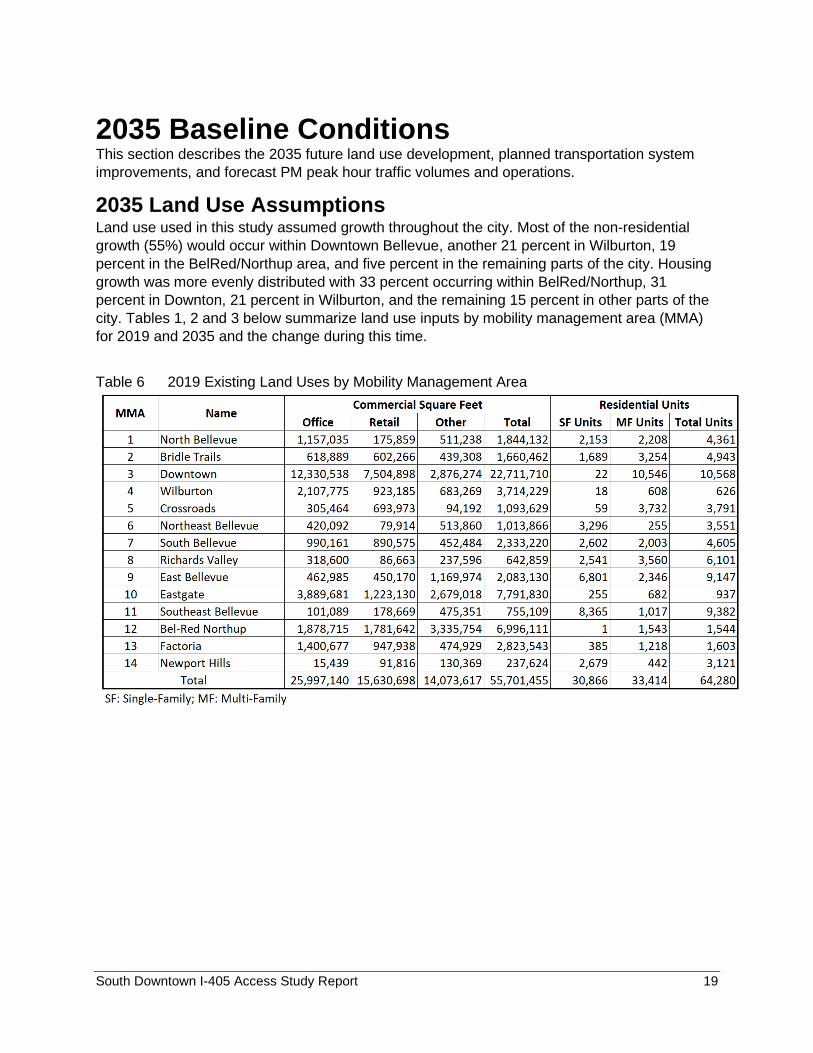
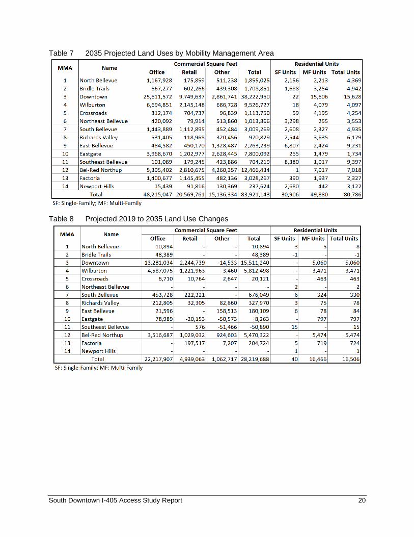
2035 Land Use Assumptions Land use used in this study assumed growth throughout the city. Most of the non-residential
growth (55%) would occur within Downtown Bellevue, another 21 percent in Wilburton, 19
percent in the BelRed/Northup area, and five percent in the remaining parts of the city. Housing
growth was more evenly distributed with 33 percent occurring within BelRed/Northup, 31
percent in Downton, 21 percent in Wilburton, and the remaining 15 percent in other parts of the
city. Tables 1, 2 and 3 below summarize land use inputs by mobility management area (MMA)
for 2019 and 2035 and the change during this time.
Table 6 2019 Existing Land Uses by Mobility Management Area
South Downtown I-405 Access Study Report 20
Table 7 2035 Projected Land Uses by Mobility Management Area
Table 8 Projected 2019 to 2035 Land Use Changes
South Downtown I-405 Access Study Report 21
Figure 6 Non-residential and Housing Unit Growth Distribution
2035 Baseline Network Assumptions The assumed 2035 baseline transportation network includes currently funded capacity projects
(auto, transit, and bike projects) within the City limits and other major projects in or near the
study area that are planned and expected to be completed by 2035. Specifically, the projects
listed below are included in the 2035 baseline demand model.
I-405 projects:
• I-405 Renton to Bellevue Widening and Express Toll Lanes
• NE 132nd Street ramps to/from I405 north (new partial interchange)
• Braided ramp from SR 520 WB to I-405 SB at NE 10th Street. SR 520 projects:
• SR 520 complete interchange at 124th Avenue NE (new ramps to/ from SR 520 East)
• SR 520 - 148th Ave NE Interchange - Overlake Access Ramp I-90 - Eastgate to SR 900 - Corridor Improvements
Local projects:
• NE 6th Street extension to 120th Avenue NE (through traffic between 112th Avenue NE and 116th Avenue NE is not allowed)
• 120th Avenue NE widening from NE 16th Street to Northup Way
• NE 2nd Street widening from Bellevue Way to 112th Avenue NE
• 124th Avenue NE widening from NE 12th Street to Northup Way
• Bellevue Way HOV lane southbound from 112th Avenue SE to the South Bellevue Park & Ride to align with planned southbound HOV lane from between the South Bellevue Park & Ride and I-90
• Spring Blvd between NE 12th Street and 136th PL NE
• Closure of the slip ramp to 114th Avenue NE at 112th Avenue/Main Street intersection
South Downtown I-405 Access Study Report 22
Transit and Non-motorized projects:
• Light rail between Seattle and Redmond Town Center
• Grand Connection
• Eastrail through Wilburton to Kirkland and Renton
• Lake to Lake Trail
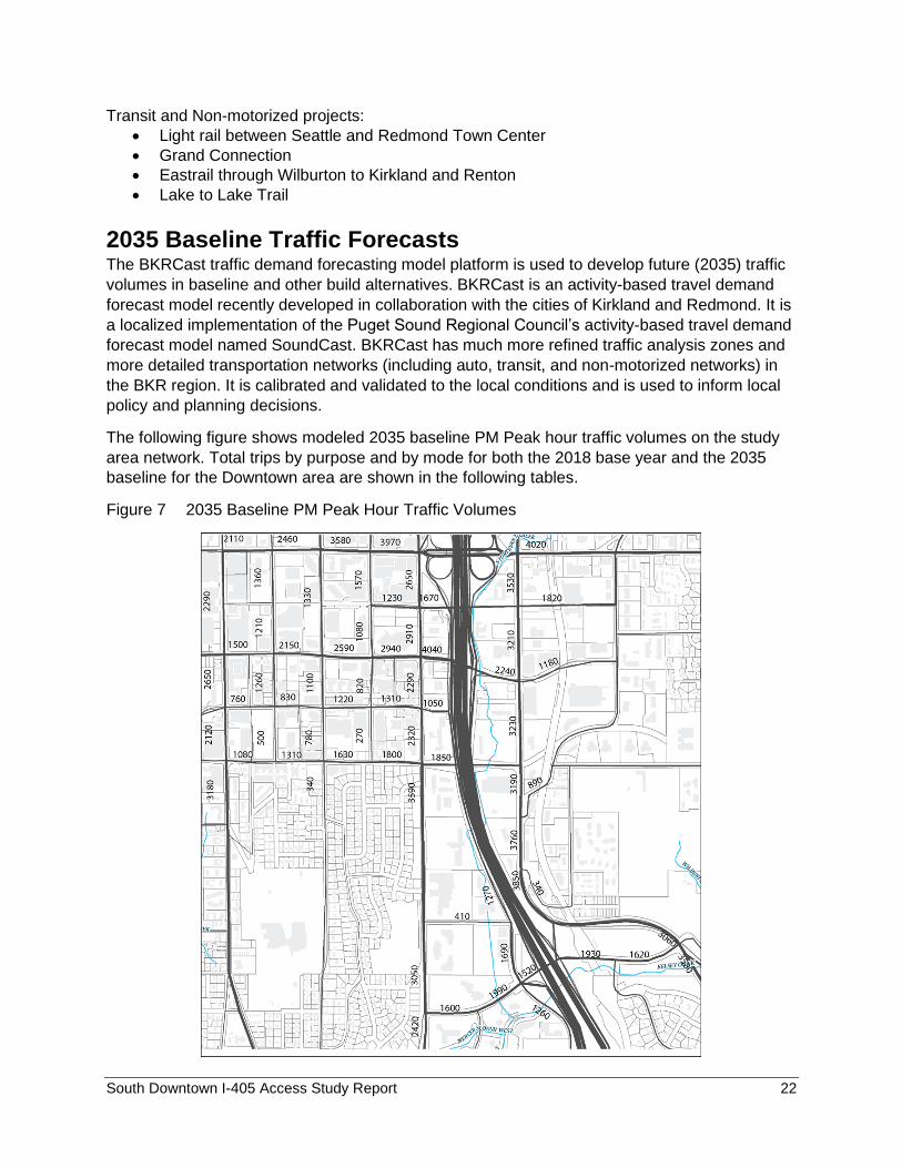
2035 Baseline Traffic Forecasts The BKRCast traffic demand forecasting model platform is used to develop future (2035) traffic
volumes in baseline and other build alternatives. BKRCast is an activity-based travel demand
forecast model recently developed in collaboration with the cities of Kirkland and Redmond. It is
a localized implementation of the Puget Sound Regional Council’s activity-based travel demand
forecast model named SoundCast. BKRCast has much more refined traffic analysis zones and
more detailed transportation networks (including auto, transit, and non-motorized networks) in
the BKR region. It is calibrated and validated to the local conditions and is used to inform local
policy and planning decisions.
The following figure shows modeled 2035 baseline PM Peak hour traffic volumes on the study
area network. Total trips by purpose and by mode for both the 2018 base year and the 2035
baseline for the Downtown area are shown in the following tables.
Figure 7 2035 Baseline PM Peak Hour Traffic Volumes
South Downtown I-405 Access Study Report 23
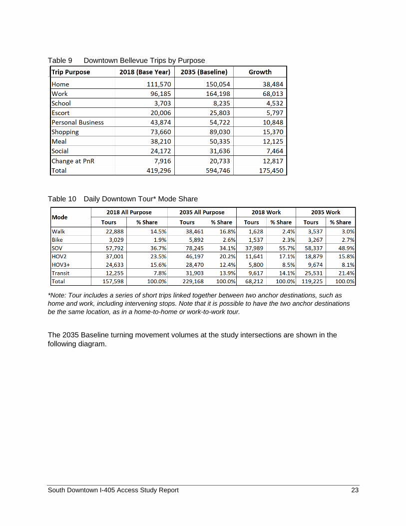
Table 9 Downtown Bellevue Trips by Purpose
Table 10 Daily Downtown Tour* Mode Share
*Note: Tour includes a series of short trips linked together between two anchor destinations, such as
home and work, including intervening stops. Note that it is possible to have the two anchor destinations
be the same location, as in a home-to-home or work-to-work tour.
The 2035 Baseline turning movement volumes at the study intersections are shown in the
following diagram.
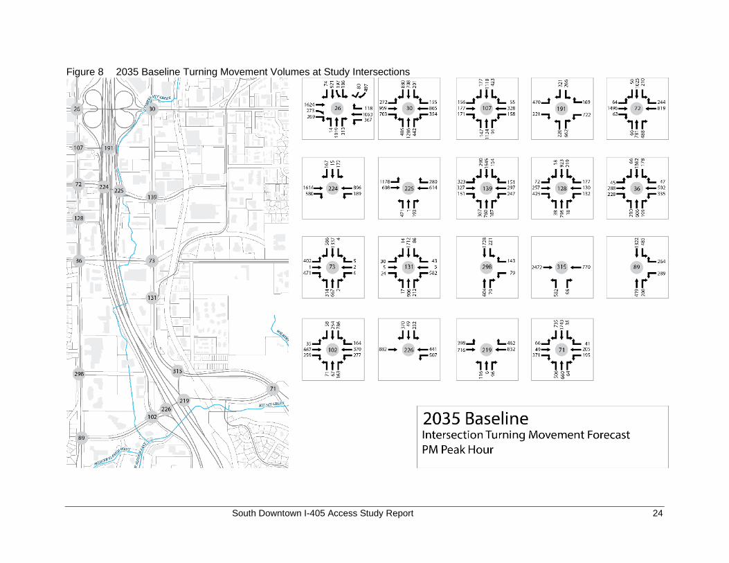
South Downtown I-405 Access Study Report 24
Figure 8 2035 Baseline Turning Movement Volumes at Study Intersections
South Downtown I-405 Access Study Report 25
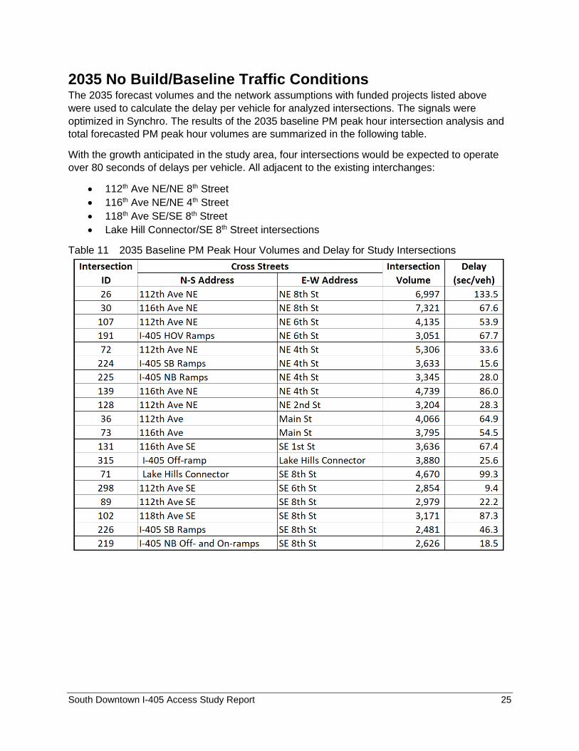
2035 No Build/Baseline Traffic Conditions The 2035 forecast volumes and the network assumptions with funded projects listed above
were used to calculate the delay per vehicle for analyzed intersections. The signals were
optimized in Synchro. The results of the 2035 baseline PM peak hour intersection analysis and
total forecasted PM peak hour volumes are summarized in the following table.
With the growth anticipated in the study area, four intersections would be expected to operate
over 80 seconds of delays per vehicle. All adjacent to the existing interchanges:
• 112th Ave NE/NE 8th Street
• 116th Ave NE/NE 4th Street
• 118th Ave SE/SE 8th Street
• Lake Hill Connector/SE 8th Street intersections
Table 11 2035 Baseline PM Peak Hour Volumes and Delay for Study Intersections
South Downtown I-405 Access Study Report 26
Alternatives Development and Analysis This section describes the approach by which the transportation alternatives were developed,
screened, and evaluated to identify alternative(s) that best meet the needs of the south
Downtown area. To set a solid foundation for ultimate FHWA approval, this process follows the
principles of the National Environmental Policy Act (NEPA), which requires the analysis and
documentation of the impacts of alternatives. The evaluation of alternatives within this study
allows agencies, stakeholders, and public to make informed choices about which alternatives
provide the best balance between meeting community needs and project goals and minimizing
environmental impacts.
Stakeholder and Community Engagement Community engagement, including stakeholders, interested groups, and the public, was an
integral part of the study process and helped ensure that the evaluation of alternatives reflects
community needs and preferences. Throughout the study process, the study team kept people
who live, work or travel through the study area informed and engaged. Engagement included
interviews, information briefings, forums, and online open houses to gain stakeholder and public
perspectives at key milestones in the study process.
Alternative Evaluation Criteria Following the guiding principles established for the study, evaluation criteria and performance
measures were developed as described in this section. These criteria and performance
measures were used to evaluate the alternatives, which is described in the subsequent
sections.
• Align with and support adopted plans and policies
The criteria and performance measures for this principle are qualitative and were assessed
within the framework of:
- Alignment with the I-405 Master Plan
- Alignment with the City’s transportation plans and policies
- Alignment with the City’s environmental stewardship policies and minimization of
impacts to natural environment
- Alignment with the adopted East Main TOD policies
- Alignment with Sound Transit planned light rail from Kirkland to Issaquah via Bellevue
• Reduce congestion and improve system performance
The criteria and performance measures for this principle include:
- Travel time/travel time savings
- Intersection average delay per vehicle
• Encourage safe multimodal connections
The criteria and performance measures for this principle are:
- Access capacity added to I-405
South Downtown I-405 Access Study Report 27
- Impact to multimodal access, connectivity, and safety
o 114th Avenue NE
o Lake to Lake Trail along Main Street
o Non-motorized access to East Main light rail station and Bellevue Transit Center
- Impact to potential vehicle collisions
• Support economic development and minimize property impacts
The criterion for this principle is:
- Amount of right-of-way needed and measured in acres
• Manage cost and minimize environmental Impacts
The criteria and performance measures for this principle are:
- Cost to acquire properties for right-of-way
- Preliminary engineering and construction cost
- Utilities relocation
- Wetland mitigation
- Removal of fish barriers and restoration of stream connections
Development of Alternatives The Study Team began by identifying options between NE 4th Street and SE 8th Street. Over
the course of multiple meetings, the Team identified 12 concepts that had the potential to meet
the project’s Purpose and Need statement. The 12 concepts are described with their conceptual
drawings below.
South Downtown I-405 Access Study Report 28
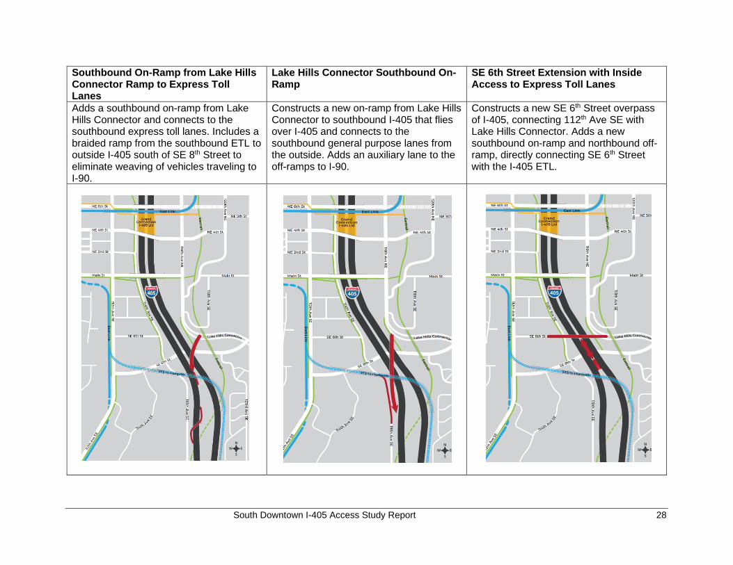
Southbound On-Ramp from Lake Hills Connector Ramp to Express Toll Lanes
Lake Hills Connector Southbound On-Ramp
SE 6th Street Extension with Inside Access to Express Toll Lanes
Adds a southbound on-ramp from Lake Hills Connector and connects to the southbound express toll lanes. Includes a braided ramp from the southbound ETL to outside I-405 south of SE 8th Street to eliminate weaving of vehicles traveling to I-90.
Constructs a new on-ramp from Lake Hills Connector to southbound I-405 that flies over I-405 and connects to the southbound general purpose lanes from the outside. Adds an auxiliary lane to the off-ramps to I-90.
Constructs a new SE 6th Street overpass of I-405, connecting 112th Ave SE with Lake Hills Connector. Adds a new southbound on-ramp and northbound off-ramp, directly connecting SE 6th Street with the I-405 ETL.
South Downtown I-405 Access Study Report 29
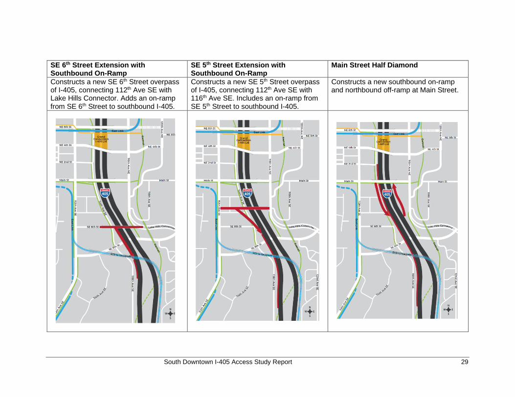
SE 6th Street Extension with Southbound On-Ramp
SE 5th Street Extension with Southbound On-Ramp
Main Street Half Diamond
Constructs a new SE 6th Street overpass of I-405, connecting 112th Ave SE with Lake Hills Connector. Adds an on-ramp from SE 6th Street to southbound I-405.
Constructs a new SE 5th Street overpass of I-405, connecting 112th Ave SE with 116th Ave SE. Includes an on-ramp from SE 5th Street to southbound I-405.
Constructs a new southbound on-ramp and northbound off-ramp at Main Street.
South Downtown I-405 Access Study Report 30
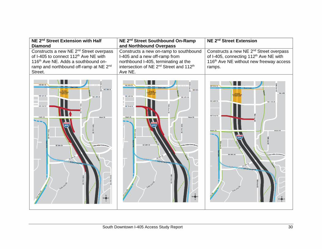
NE 2nd Street Extension with Half Diamond
NE 2nd Street Southbound On-Ramp and Northbound Overpass
NE 2nd Street Extension
Constructs a new NE 2nd Street overpass of I-405 to connect 112th Ave NE with 116th Ave NE. Adds a southbound on-ramp and northbound off-ramp at NE 2nd Street.
Constructs a new on-ramp to southbound I-405 and a new off-ramp from northbound I-405, terminating at the intersection of NE 2nd Street and 112th Ave NE.
Constructs a new NE 2nd Street overpass of I-405, connecting 112th Ave NE with 116th Ave NE without new freeway access ramps.
South Downtown I-405 Access Study Report 31
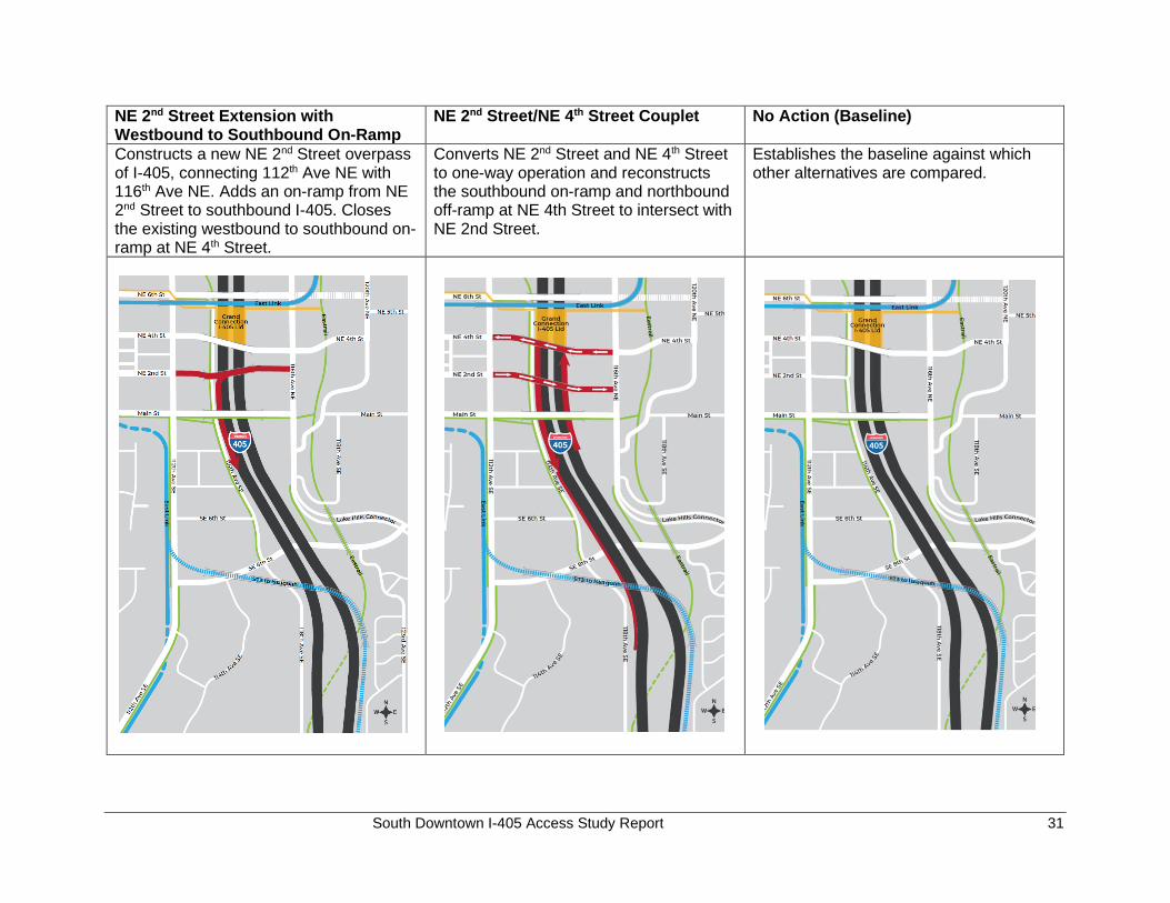
NE 2nd Street Extension with Westbound to Southbound On-Ramp
NE 2nd Street/NE 4th Street Couplet No Action (Baseline)
Constructs a new NE 2nd Street overpass of I-405, connecting 112th Ave NE with 116th Ave NE. Adds an on-ramp from NE 2nd Street to southbound I-405. Closes the existing westbound to southbound on-ramp at NE 4th Street.
Converts NE 2nd Street and NE 4th Street to one-way operation and reconstructs the southbound on-ramp and northbound off-ramp at NE 4th Street to intersect with NE 2nd Street.
Establishes the baseline against which other alternatives are compared.
South Downtown I-405 Access Study Report 32
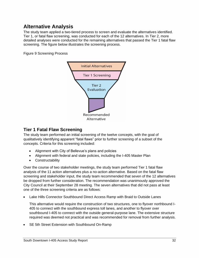
Alternative Analysis The study team applied a two-tiered process to screen and evaluate the alternatives identified. Tier 1, or fatal flaw screening, was conducted for each of the 12 alternatives. In Tier 2, more detailed analyses were conducted for the remaining alternatives that passed the Tier 1 fatal flaw screening. The figure below illustrates the screening process.
Figure 9 Screening Process
Tier 1 Fatal Flaw Screening The study team performed an initial screening of the twelve concepts, with the goal of
qualitatively identifying apparent “fatal flaws” prior to further screening of a subset of the
concepts. Criteria for this screening included:
• Alignment with City of Bellevue’s plans and policies
• Alignment with federal and state policies, including the I-405 Master Plan
• Constructability
Over the course of two stakeholder meetings, the study team performed Tier 1 fatal flaw
analysis of the 11 action alternatives plus a no-action alternative. Based on the fatal flaw
screening and stakeholder input, the study team recommended that seven of the 12 alternatives
be dropped from further consideration. The recommendation was unanimously approved the
City Council at their September 28 meeting. The seven alternatives that did not pass at least
one of the three screening criteria are as follows:
• Lake Hills Connector Southbound Direct Access Ramp with Braid to Outside Lanes
This alternative would require the construction of two structures, one to flyover northbound I-
405 to connect with the southbound express toll lanes, and another to flyover over
southbound I-405 to connect with the outside general-purpose lane. The extensive structure
required was deemed not practical and was recommended for removal from further analysis.
• SE 5th Street Extension with Southbound On-Ramp
South Downtown I-405 Access Study Report 33
This alternative conflicts with several Comprehensive Plan policies that support the East
Main TOD vision. The area surrounding SE 5th Street is the East Main TOD land use
district. This area is envisioned in the Southwest Bellevue Subarea Plan (2019) as a vibrant,
livable transit-oriented station area of safe, walkable and bikeable blocks served by light rail.
A connection to I-405 via a SE 5th Street extension and subsequent increase in traffic
volume and reduction in developable land would not be compatible with this vision.
• Main Street Half Diamond
This alternative does not align with several planning policies. Main Street is envisioned as a
pedestrian and bike friendly street with an ‘Old Bellevue’ look and feel. Additionally, the
planned Lake to Lake Trail runs along Main Street and the East Main light rail station is
located at Main Street and 112th Avenue NE. Providing access to I-405 from Main Street
would draw significantly more vehicle traffic to Main Street, which would make the Lake to
Lake Trail much less attractive for bikers and pedestrians. It would also create a traffic
barrier between Downtown and the East Main Station and make the station more difficult to
access. Furthermore, the ramps would displace a significant section of 114th Avenue SE,
which is envisioned as a critical facility to support the land use vision in the south Downtown
area. To preserve 114th Avenue SE, the ramps would have to be elevated for an extended
distance along the planned East Main TOD area. The elevated structure would incur
significant cost and would not be compatible with the planned character of the East Main
TOD.
• NE 2nd Street Extension with Westbound to Southbound On-Ramp
In order for NE 2nd Street to cross above I-405 and intersect with a new southbound on-
ramp, the NE 2nd Street profile grade would be greater than 5%. Meeting Americans with
Disabilities Act (ADA) criteria through the intersection, while on the structure, would not be
feasible. The intersection of NE 2nd Street with the new on-ramp terminal would be located
above the existing southbound freeway and ramp lanes.
• NE 2nd Street Extension with Half Diamond
The NE 2nd Street Extension alignment would run parallel to, and roughly 500 feet north of,
Main Street. The separation between the proposed NE 2nd Street bridge and the existing
Main Street bridge would be too short to accommodate required vertical alignments for the
new ramps. A further complication is that the I-405 Renton to Bellevue Widening and
Express Toll Lanes, currently under construction, include a north side widening of the Main
Street bridge. The ETL project reserved space for the southbound ramps by identifying a
portal west of 114th. Were this to be used, it would significantly impact redevelopment of the
properties west of 114th.
The study team also looked at how the NE 2nd Street bridge would impact property access.
To cross over I-405, NE 2nd Street would need to climb at a steep rate. The elevated
section of roadway and bridge would eliminate any at-grade access to NE 2nd Street from
adjacent properties. It would also require closing the intersection at 114th Avenue NE, and
NE 2nd Street would no longer provide an east-west connection between 112th Avenue NE
and 114th Avenue NE. This would also have land use implications as it prevents access to
the backside of properties off 114th to the north.
South Downtown I-405 Access Study Report 34
• NE 2nd Street Southbound On-Ramp and Northbound Overpass
With limited space available, right of way would have to be acquired to accommodate the
new southbound on-ramp and northbound off-ramp for this concept. Several parcels along
both sides of I-405 would be impacted. The termination of the ramps at NE 2nd Street would
require closing a significant portion of 114th Avenue NE and eliminating the access to 114th
Avenue NE from NE 2nd Street. This would have land use implications as it prevents access
to the backside of properties off 114th to the north.
The new northbound off-ramp would be constructed primarily on a bridge, crossing above
Main Street and I-405. The complex and expensive structure would be difficult to construct
above the existing freeway, with traffic impacts for an estimated two to three years of
duration.
• NE 2nd Street/NE 4th Street Couplet
The couplet would reconfigure NE 4th Street and NE 2nd Street to one-way operation and
construct a new NE 2nd Street overcrossing. Two new freeway ramps would be constructed,
and the existing ramps from NE 4th Street would be reconstructed as north-south
connections between NE 2nd Street and NE 4th Street. Most construction activities would
occur within the existing freeway, in confined right of way, with major impacts to traffic for an
estimated three-year duration.
The increased footprint of the new connections would require reconstruction of the existing
ramps from NE 8th Street, impacting 114th Avenue NE, properties along 114th Avenue NE,
and properties adjacent to the freeway.
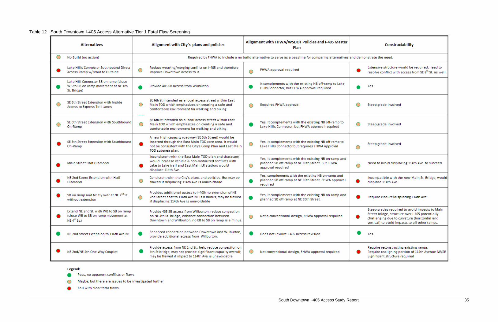
Tier 1 fatal flaw screening assessments are summarized in the following table. Each
alternative is assigned a colored circle under each of the three screening criteria. A red
circle denotes failed to pass the criterion; an orange circle indicates a likely pass, but further
evaluation is needed; a green circle indicates a pass. An alternative is deemed as “fatally
flawed” if it gets a red circle under one or more criteria.
South Downtown I-405 Access Study Report 35
Table 12 South Downtown I-405 Access Alternative Tier 1 Fatal Flaw Screening
South Downtown I-405 Access Study Report 36
Tier 2 Alternatives Conceptual Design and Analysis
The study team presented the four action alternatives that passed Tier 1 fatal flaw screening
along with the No Action alternative to the City Council at their September 28, 2020 meeting.
The Council unanimously voted to support the staff recommendation to carry forward five
alternatives to Tier 2 for further evaluation.
To carry out the Tier 2 analysis, the study design team completed conceptual designs for the
four action alternatives. Conceptual design included preliminary horizontal and vertical geometry
development, selection of roadway widths in coordination with traffic analysis, selection of
nonmotorized facilities, and three-dimensional modeling. Variations in roadway alignment, lane
configuration, and nonmotorized facilities were considered.
Construction quantities were derived from computer generated models and plan take-offs.
Impacts to property, potential property acquisitions, known utilities, and environmentally
sensitive areas were quantified. Source data included City of Bellevue GIS and staff, King
County GIS, as-builts, Washington Department of Transportation surveys from adjacent
projects, Washington Department of Fish and Wildlife databases, and National Fish and Wildlife
wetlands databases.
The study team evaluated the benefits, impacts, and cost of each option. Trade-offs associated
with the options are described below.
NE 2nd Street Extension – Alternative Alignments West of I-405, the NE 2nd Street Extension alignment is constrained to following the existing
roadway alignment. East of I-405, two alignment alternatives were considered:
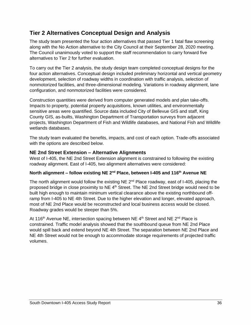
North alignment – follow existing NE 2nd Place, between I-405 and 116th Avenue NE
The north alignment would follow the existing NE 2nd Place roadway, east of I-405, placing the
proposed bridge in close proximity to NE 4th Street. The NE 2nd Street bridge would need to be
built high enough to maintain minimum vertical clearance above the existing northbound off-
ramp from I-405 to NE 4th Street. Due to the higher elevation and longer, elevated approach,
most of NE 2nd Place would be reconstructed and local business access would be closed.
Roadway grades would be steeper than 5%.
At 116th Avenue NE, intersection spacing between NE 4th Street and NE 2nd Place is
constrained. Traffic model analysis showed that the southbound queue from NE 2nd Place
would spill back and extend beyond NE 4th Street. The separation between NE 2nd Place and
NE 4th Street would not be enough to accommodate storage requirements of projected traffic
volumes.
South Downtown I-405 Access Study Report 37
Figure 10 Concept Design for NE 2nd Street North Alignment
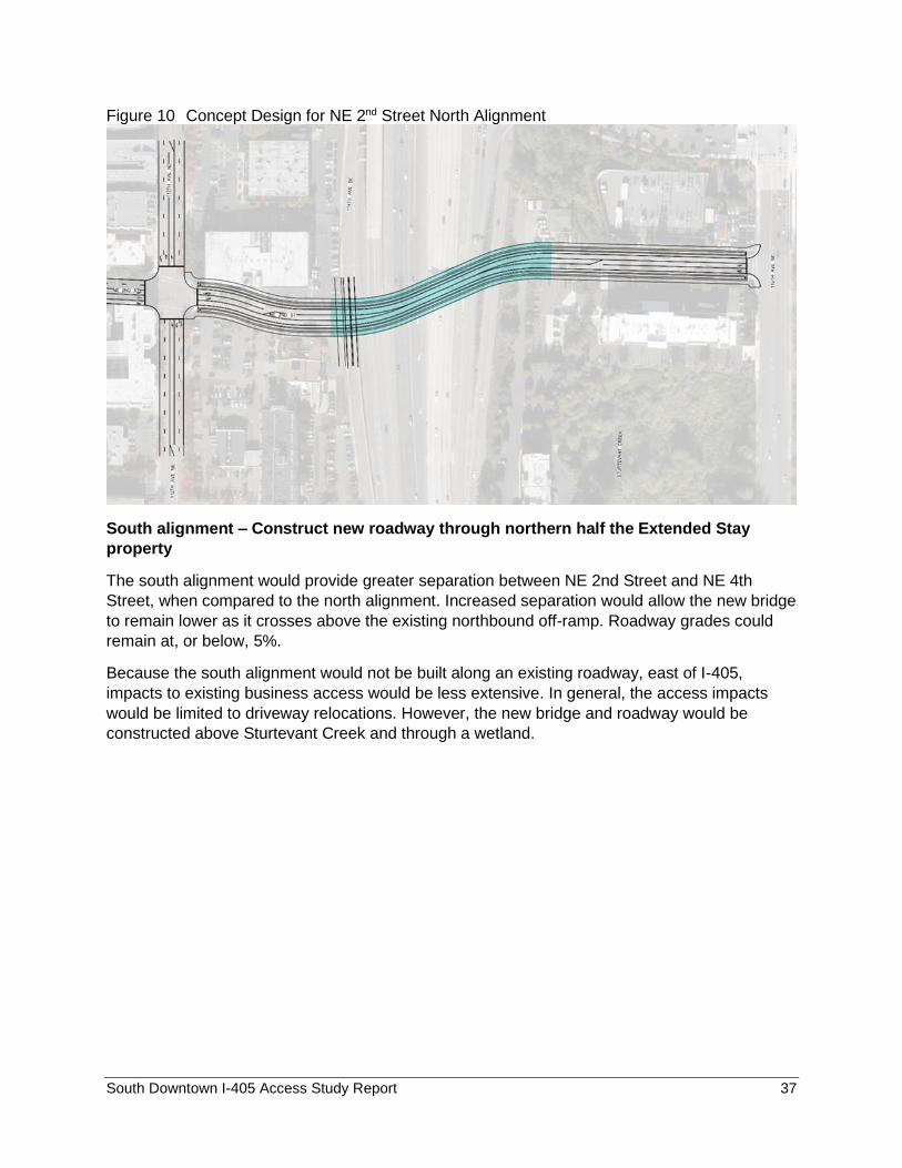
South alignment – Construct new roadway through northern half the Extended Stay
property
The south alignment would provide greater separation between NE 2nd Street and NE 4th
Street, when compared to the north alignment. Increased separation would allow the new bridge
to remain lower as it crosses above the existing northbound off-ramp. Roadway grades could
remain at, or below, 5%.
Because the south alignment would not be built along an existing roadway, east of I-405,
impacts to existing business access would be less extensive. In general, the access impacts
would be limited to driveway relocations. However, the new bridge and roadway would be
constructed above Sturtevant Creek and through a wetland.
South Downtown I-405 Access Study Report 38
Figure 11 Concept Design for NE 2nd Street South Alignment
The study team recommended advancing the south alignment of the NE 2nd Street Extension
alternative.
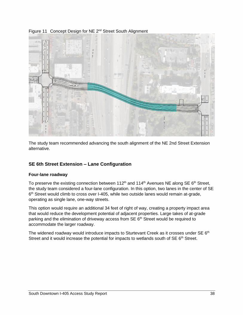
SE 6th Street Extension – Lane Configuration
Four-lane roadway
To preserve the existing connection between 112th and 114th Avenues NE along SE 6th Street,
the study team considered a four-lane configuration. In this option, two lanes in the center of SE
6th Street would climb to cross over I-405, while two outside lanes would remain at-grade,
operating as single lane, one-way streets.
This option would require an additional 34 feet of right of way, creating a property impact area
that would reduce the development potential of adjacent properties. Large takes of at-grade
parking and the elimination of driveway access from SE 6th Street would be required to
accommodate the larger roadway.
The widened roadway would introduce impacts to Sturtevant Creek as it crosses under SE 6th
Street and it would increase the potential for impacts to wetlands south of SE 6th Street.
South Downtown I-405 Access Study Report 39
Figure 12 Concept Design for SE 6th Street Four Lane Roadway
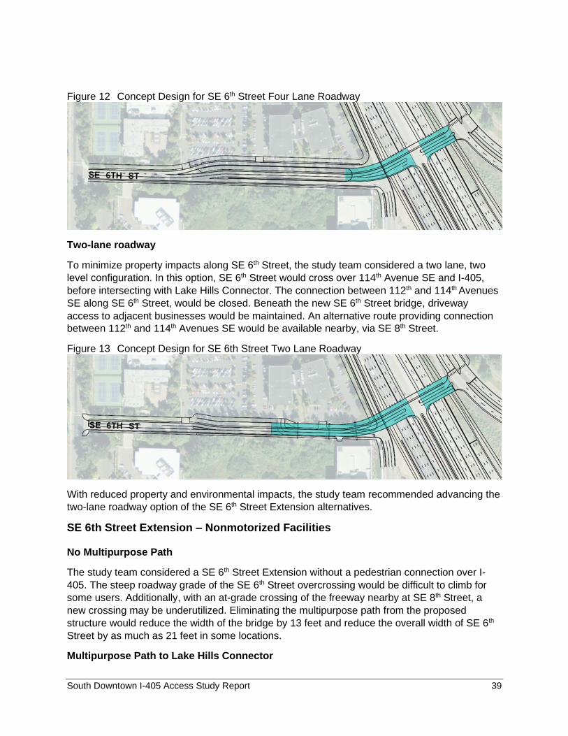
Two-lane roadway
To minimize property impacts along SE 6th Street, the study team considered a two lane, two
level configuration. In this option, SE 6th Street would cross over 114th Avenue SE and I-405,
before intersecting with Lake Hills Connector. The connection between 112th and 114th Avenues
SE along SE 6th Street, would be closed. Beneath the new SE 6th Street bridge, driveway
access to adjacent businesses would be maintained. An alternative route providing connection
between 112th and 114th Avenues SE would be available nearby, via SE 8th Street.
Figure 13 Concept Design for SE 6th Street Two Lane Roadway
With reduced property and environmental impacts, the study team recommended advancing the
two-lane roadway option of the SE 6th Street Extension alternatives.
SE 6th Street Extension – Nonmotorized Facilities
No Multipurpose Path
The study team considered a SE 6th Street Extension without a pedestrian connection over I-
405. The steep roadway grade of the SE 6th Street overcrossing would be difficult to climb for
some users. Additionally, with an at-grade crossing of the freeway nearby at SE 8th Street, a
new crossing may be underutilized. Eliminating the multipurpose path from the proposed
structure would reduce the width of the bridge by 13 feet and reduce the overall width of SE 6th
Street by as much as 21 feet in some locations.
Multipurpose Path to Lake Hills Connector
South Downtown I-405 Access Study Report 40
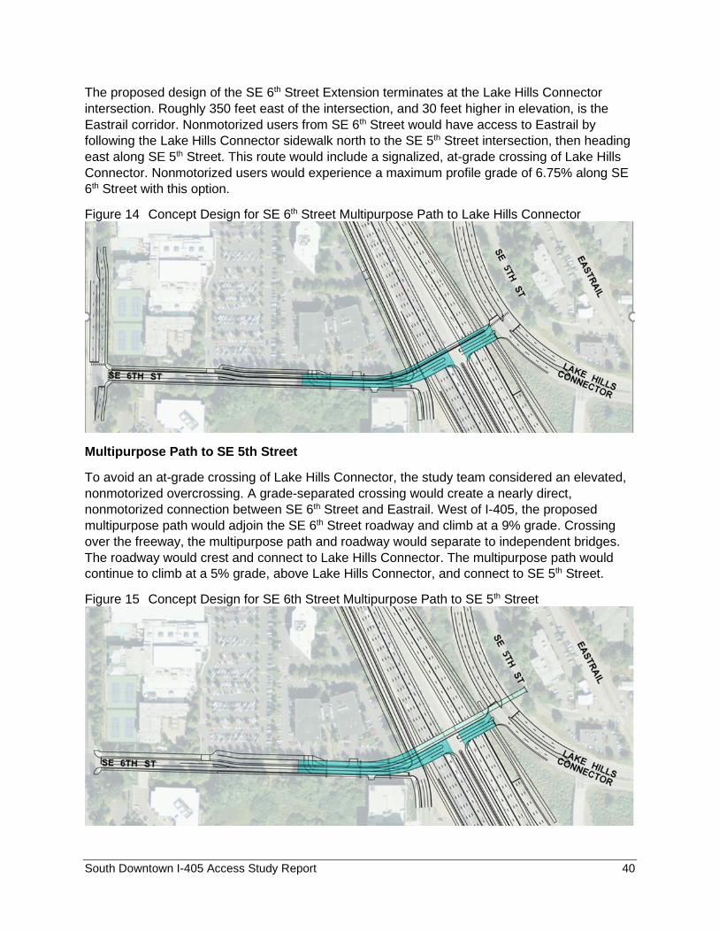
The proposed design of the SE 6th Street Extension terminates at the Lake Hills Connector
intersection. Roughly 350 feet east of the intersection, and 30 feet higher in elevation, is the
Eastrail corridor. Nonmotorized users from SE 6th Street would have access to Eastrail by
following the Lake Hills Connector sidewalk north to the SE 5th Street intersection, then heading
east along SE 5th Street. This route would include a signalized, at-grade crossing of Lake Hills
Connector. Nonmotorized users would experience a maximum profile grade of 6.75% along SE
6th Street with this option.
Figure 14 Concept Design for SE 6th Street Multipurpose Path to Lake Hills Connector
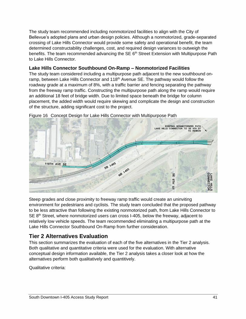
Multipurpose Path to SE 5th Street
To avoid an at-grade crossing of Lake Hills Connector, the study team considered an elevated,
nonmotorized overcrossing. A grade-separated crossing would create a nearly direct,
nonmotorized connection between SE 6th Street and Eastrail. West of I-405, the proposed
multipurpose path would adjoin the SE 6th Street roadway and climb at a 9% grade. Crossing
over the freeway, the multipurpose path and roadway would separate to independent bridges.
The roadway would crest and connect to Lake Hills Connector. The multipurpose path would
continue to climb at a 5% grade, above Lake Hills Connector, and connect to SE 5th Street.
Figure 15 Concept Design for SE 6th Street Multipurpose Path to SE 5th Street
South Downtown I-405 Access Study Report 41
The study team recommended including nonmotorized facilities to align with the City of
Bellevue’s adopted plans and urban design policies. Although a nonmotorized, grade-separated
crossing of Lake Hills Connector would provide some safety and operational benefit, the team
determined constructability challenges, cost, and required design variances to outweigh the
benefits. The team recommended advancing the SE 6th Street Extension with Multipurpose Path
to Lake Hills Connector.
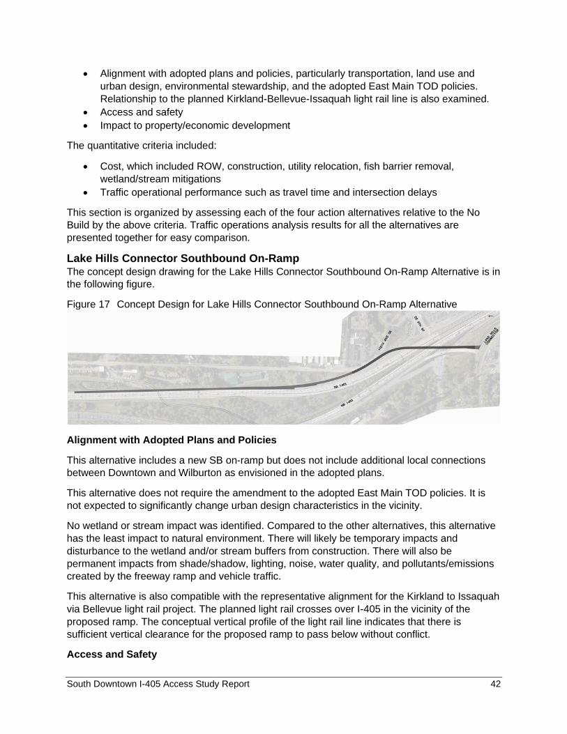
Lake Hills Connector Southbound On-Ramp – Nonmotorized Facilities The study team considered including a multipurpose path adjacent to the new southbound on-
ramp, between Lake Hills Connector and 118th Avenue SE. The pathway would follow the
roadway grade at a maximum of 8%, with a traffic barrier and fencing separating the pathway
from the freeway ramp traffic. Constructing the multipurpose path along the ramp would require
an additional 18 feet of bridge width. Due to limited space beneath the bridge for column
placement, the added width would require skewing and complicate the design and construction
of the structure, adding significant cost to the project.
Figure 16 Concept Design for Lake Hills Connector with Multipurpose Path
Steep grades and close proximity to freeway ramp traffic would create an uninviting
environment for pedestrians and cyclists. The study team concluded that the proposed pathway
to be less attractive than following the existing nonmotorized path, from Lake Hills Connector to
SE 8th Street, where nonmotorized users can cross I-405, below the freeway, adjacent to
relatively low vehicle speeds. The team recommended eliminating a multipurpose path at the
Lake Hills Connector Southbound On-Ramp from further consideration.
Tier 2 Alternatives Evaluation This section summarizes the evaluation of each of the five alternatives in the Tier 2 analysis.
Both qualitative and quantitative criteria were used for the evaluation. With alternative
conceptual design information available, the Tier 2 analysis takes a closer look at how the
alternatives perform both qualitatively and quantitively.
Qualitative criteria:
South Downtown I-405 Access Study Report 42
• Alignment with adopted plans and policies, particularly transportation, land use and
urban design, environmental stewardship, and the adopted East Main TOD policies.
Relationship to the planned Kirkland-Bellevue-Issaquah light rail line is also examined.
• Access and safety
• Impact to property/economic development
The quantitative criteria included:
• Cost, which included ROW, construction, utility relocation, fish barrier removal,
wetland/stream mitigations
• Traffic operational performance such as travel time and intersection delays
This section is organized by assessing each of the four action alternatives relative to the No
Build by the above criteria. Traffic operations analysis results for all the alternatives are
presented together for easy comparison.
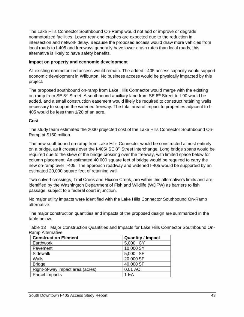
Lake Hills Connector Southbound On-Ramp The concept design drawing for the Lake Hills Connector Southbound On-Ramp Alternative is in
the following figure.
Figure 17 Concept Design for Lake Hills Connector Southbound On-Ramp Alternative
Alignment with Adopted Plans and Policies
This alternative includes a new SB on-ramp but does not include additional local connections
between Downtown and Wilburton as envisioned in the adopted plans.
This alternative does not require the amendment to the adopted East Main TOD policies. It is
not expected to significantly change urban design characteristics in the vicinity.
No wetland or stream impact was identified. Compared to the other alternatives, this alternative
has the least impact to natural environment. There will likely be temporary impacts and
disturbance to the wetland and/or stream buffers from construction. There will also be
permanent impacts from shade/shadow, lighting, noise, water quality, and pollutants/emissions
created by the freeway ramp and vehicle traffic.
This alternative is also compatible with the representative alignment for the Kirkland to Issaquah
via Bellevue light rail project. The planned light rail crosses over I-405 in the vicinity of the
proposed ramp. The conceptual vertical profile of the light rail line indicates that there is
sufficient vertical clearance for the proposed ramp to pass below without conflict.
Access and Safety
South Downtown I-405 Access Study Report 43
The Lake Hills Connector Southbound On-Ramp would not add or improve or degrade
nonmotorized facilities. Lower rear-end crashes are expected due to the reduction in
intersection and network delay. Because the proposed access would draw more vehicles from
local roads to I-405 and freeways generally have lower crash rates than local roads, this
alternative is likely to have safety benefits.
Impact on property and economic development
All existing nonmotorized access would remain. The added I-405 access capacity would support
economic development in Wilburton. No business access would be physically impacted by this
project.
The proposed southbound on-ramp from Lake Hills Connector would merge with the existing
on-ramp from SE 8th Street. A southbound auxiliary lane from SE 8th Street to I-90 would be
added, and a small construction easement would likely be required to construct retaining walls
necessary to support the widened freeway. The total area of impact to properties adjacent to I-
405 would be less than 1/20 of an acre.
Cost
The study team estimated the 2030 projected cost of the Lake Hills Connector Southbound On-
Ramp at $150 million.
The new southbound on-ramp from Lake Hills Connector would be constructed almost entirely
on a bridge, as it crosses over the I-405/ SE 8th Street interchange. Long bridge spans would be
required due to the skew of the bridge crossing over the freeway, with limited space below for
column placement. An estimated 40,000 square feet of bridge would be required to carry the
new on-ramp over I-405. The approach roadway and widened I-405 would be supported by an
estimated 20,000 square feet of retaining wall.
Two culvert crossings, Trail Creek and Hixson Creek, are within this alternative’s limits and are
identified by the Washington Department of Fish and Wildlife (WDFW) as barriers to fish
passage, subject to a federal court injunction.
No major utility impacts were identified with the Lake Hills Connector Southbound On-Ramp
alternative.
The major construction quantities and impacts of the proposed design are summarized in the
table below.
Table 13 Major Construction Quantities and Impacts for Lake Hills Connector Southbound On-Ramp Alternative
Construction Element Quantity / Impact
Earthwork 5,000 CY
Pavement 10,000 SY
Sidewalk 5,000 SF
Walls 20,000 SF
Bridge 40,000 SF
Right-of-way impact area (acres) 0.01 AC
Parcel Impacts 1 EA
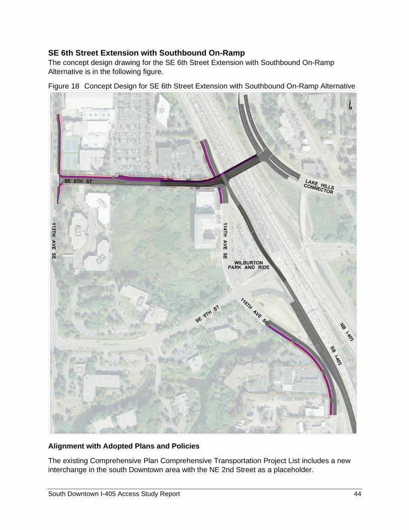
South Downtown I-405 Access Study Report 44
SE 6th Street Extension with Southbound On-Ramp The concept design drawing for the SE 6th Street Extension with Southbound On-Ramp
Alternative is in the following figure.
Figure 18 Concept Design for SE 6th Street Extension with Southbound On-Ramp Alternative
Alignment with Adopted Plans and Policies
The existing Comprehensive Plan Comprehensive Transportation Project List includes a new
interchange in the south Downtown area with the NE 2nd Street as a placeholder.
South Downtown I-405 Access Study Report 45
The area surrounding SE 6th Street is the East Main Transit-Oriented Development land use
district. This area is envisioned in the Southwest Bellevue Subarea Plan (2019) as a vibrant,
livable transit-oriented station area of safe, walkable and bikeable blocks served by light rail. A
connection to I-405 via a SE 6th Street extension and subsequent increase in traffic volume and
reduction in developable land may not be compatible with this vision.
Buildings sited along SE 6th Street and within the TOD are intended to serve the new mixed-
use neighborhood. Freeway access ramps at SE 6th Street have the potential to change the
intended character, appearance, and physical characteristics of the site.
There will likely be temporary impacts and disturbance to the wetland and/or stream buffers
from construction. There will also be permanent impacts from shade/shadow, lighting, noise,
water quality, and pollutants/emissions created by the freeway ramp and vehicle traffic.
This alternative does not have conflict with the planned light rail from Kirkland to Issaquah via
Bellevue.
Access and Safety
A new motorized connection would be added in the south Downtown and Wilburton areas,
connecting 112th Avenue with 116th Avenue/Lake Hills Connector via SE 6th Street. A new
signalized intersection would be constructed at Lake Hills Connector. The motorized connection
between 112th Avenue SE and 114th Avenue SE would be closed.
A new nonmotorized path would be constructed along the north side of the SE 6th Street bridge.
This path would connect SE 6th Street with the Eastrail Corridor via Lake Hills Connector and
SE 5th Street. Although the new nonmotorized path would increase the available options for
crossing I-405, the pedestrian and cyclist experience would be less than ideal due to the steep
grades required. Existing nonmotorized facilities along 112th Avenue SE, 114th Avenue SE, and
SE 6th Street would be improved.
The southbound on-ramp option would include minor realignment of 118th Avenue SE to provide
the width necessary for the new ramp between I-405 and 118th Avenue SE. Realignment would
include reconstruction and widening of the nonmotorized facilities along the west side of 118th
Avenue SE.
Nonmotorized facilities included in this alternative would provide another access to the East
Main light rail station for residents living in the South Wilburton and Woodridge neighborhoods.
The increase in vehicular traffic on 112th Avenue SE will negatively impact passenger travel
between the light rail station and the TOD.
Due to reductions in intersection and network delay, lower rear-end crashes would be expected.
The proposed access would allow more freeway travel, which tends to have lower crash rates
than local roads.
Impact on Property Development
Several properties along 112th Avenue SE, 114th Avenue SE, and SE 6th Street would be
impacted due to added lanes and widened nonmotorized facilities. Impacts would be limited to
parking lots and planter strips, with roughly ½ acre in total impact area, including temporary and
permanent easements, and no impact to existing structures.
South Downtown I-405 Access Study Report 46
The proposed reconstruction of SE 6th Street would eliminate the east-west connection between
112th Avenue SE and 114th Avenue SE. Beneath the new SE 6th Street structure, driveway
access to adjacent businesses along SE 6th Street would be maintained.
Realignment of 118th Avenue SE and the proposed nonmotorized improvements would
generate some minor impacts to adjacent properties. However, these impacts would be limited
to planter strip and driveway reconstruction. No impact to developable property is expected.
The new southbound on-ramp from SE 6th Street would be constructed on a new bridge above
the existing southbound off-ramp to SE 8th Street and the Wilburton Park and Ride. Impacts to
the ramp and park and ride would be minimal, limited to the space required to construct the
bridge and bridge columns.
The modest amount of ROW needed (see Table 15) could reduce the development potential.
However, opportunity exists for property owners to dedicate property in exchange for retaining
the same development capacity.
Cost
The study team estimated the 2030 projected cost of the SE 6th Street Extension with
Southbound On-Ramp at $175 million A new SE 6th Street bridge over I-405, a new bridge for
the southbound on-ramp, and retaining walls for the approach roadway are the primary
structural cost drivers. Roughly 55,000 square feet of new bridge and 35,000 square feet of new
retaining wall would be required to construct the southbound on-ramp alternative.
One culvert crossing, Hixson Creek, is within this alternative’s limits and is identified by the
Washington Department of Fish and Wildlife (WDFW) as a barrier to fish passage, subject to a
federal court injunction.
City of Bellevue and King County utilities were identified within the project area. Wastewater and
storm sewer lines may require relocation. As the roadway reconstruction would be at, or above,
grade, access concerns from the street level would dictate the need for relocation. Relocation
costs for unavoidable impacts are anticipated to be minimal.
The major construction quantities and impacts of the proposed design are summarized in the
table below.
Table 14 Major Construction Quantities and Impacts for SE 6th Street Extension with Southbound On-Ramp Alternative
Construction Element Quantity / Impact
Earthwork 20,000 CY
Pavement 25,000 SY
Sidewalk 55,000 SF
Walls 35,000 SF
Bridge 55,000 SF
Right-of-way impact area (acres) 0.82 AC
Parcel Impacts 8 EA
SE 6th Street Extension with Direct Access The concept design drawing for the SE 6th Street Extension with Direct Access Alternative is in
the following figure.
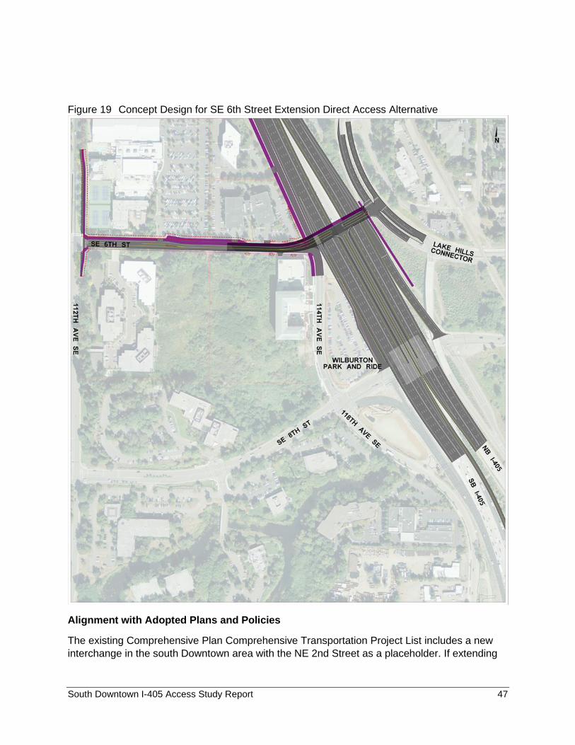
South Downtown I-405 Access Study Report 47
Figure 19 Concept Design for SE 6th Street Extension Direct Access Alternative
Alignment with Adopted Plans and Policies
The existing Comprehensive Plan Comprehensive Transportation Project List includes a new
interchange in the south Downtown area with the NE 2nd Street as a placeholder. If extending
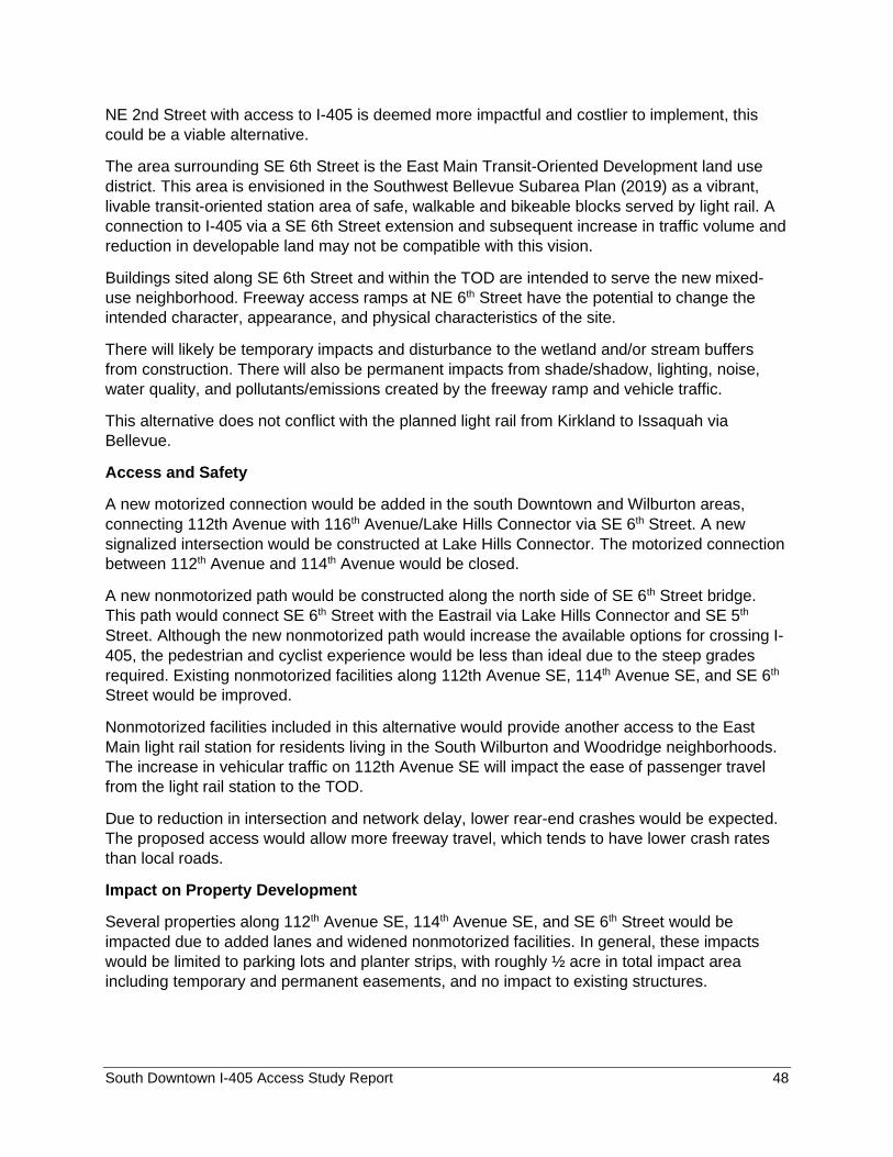
South Downtown I-405 Access Study Report 48
NE 2nd Street with access to I-405 is deemed more impactful and costlier to implement, this
could be a viable alternative.
The area surrounding SE 6th Street is the East Main Transit-Oriented Development land use
district. This area is envisioned in the Southwest Bellevue Subarea Plan (2019) as a vibrant,
livable transit-oriented station area of safe, walkable and bikeable blocks served by light rail. A
connection to I-405 via a SE 6th Street extension and subsequent increase in traffic volume and
reduction in developable land may not be compatible with this vision.
Buildings sited along SE 6th Street and within the TOD are intended to serve the new mixed-
use neighborhood. Freeway access ramps at NE 6th Street have the potential to change the
intended character, appearance, and physical characteristics of the site.
There will likely be temporary impacts and disturbance to the wetland and/or stream buffers
from construction. There will also be permanent impacts from shade/shadow, lighting, noise,
water quality, and pollutants/emissions created by the freeway ramp and vehicle traffic.
This alternative does not conflict with the planned light rail from Kirkland to Issaquah via
Bellevue.
Access and Safety
A new motorized connection would be added in the south Downtown and Wilburton areas,
connecting 112th Avenue with 116th Avenue/Lake Hills Connector via SE 6th Street. A new
signalized intersection would be constructed at Lake Hills Connector. The motorized connection
between 112th Avenue and 114th Avenue would be closed.
A new nonmotorized path would be constructed along the north side of SE 6th Street bridge.
This path would connect SE 6th Street with the Eastrail via Lake Hills Connector and SE 5th
Street. Although the new nonmotorized path would increase the available options for crossing I-
405, the pedestrian and cyclist experience would be less than ideal due to the steep grades
required. Existing nonmotorized facilities along 112th Avenue SE, 114th Avenue SE, and SE 6th
Street would be improved.
Nonmotorized facilities included in this alternative would provide another access to the East
Main light rail station for residents living in the South Wilburton and Woodridge neighborhoods.
The increase in vehicular traffic on 112th Avenue SE will impact the ease of passenger travel
from the light rail station to the TOD.
Due to reduction in intersection and network delay, lower rear-end crashes would be expected.
The proposed access would allow more freeway travel, which tends to have lower crash rates
than local roads.
Impact on Property Development
Several properties along 112th Avenue SE, 114th Avenue SE, and SE 6th Street would be
impacted due to added lanes and widened nonmotorized facilities. In general, these impacts
would be limited to parking lots and planter strips, with roughly ½ acre in total impact area
including temporary and permanent easements, and no impact to existing structures.
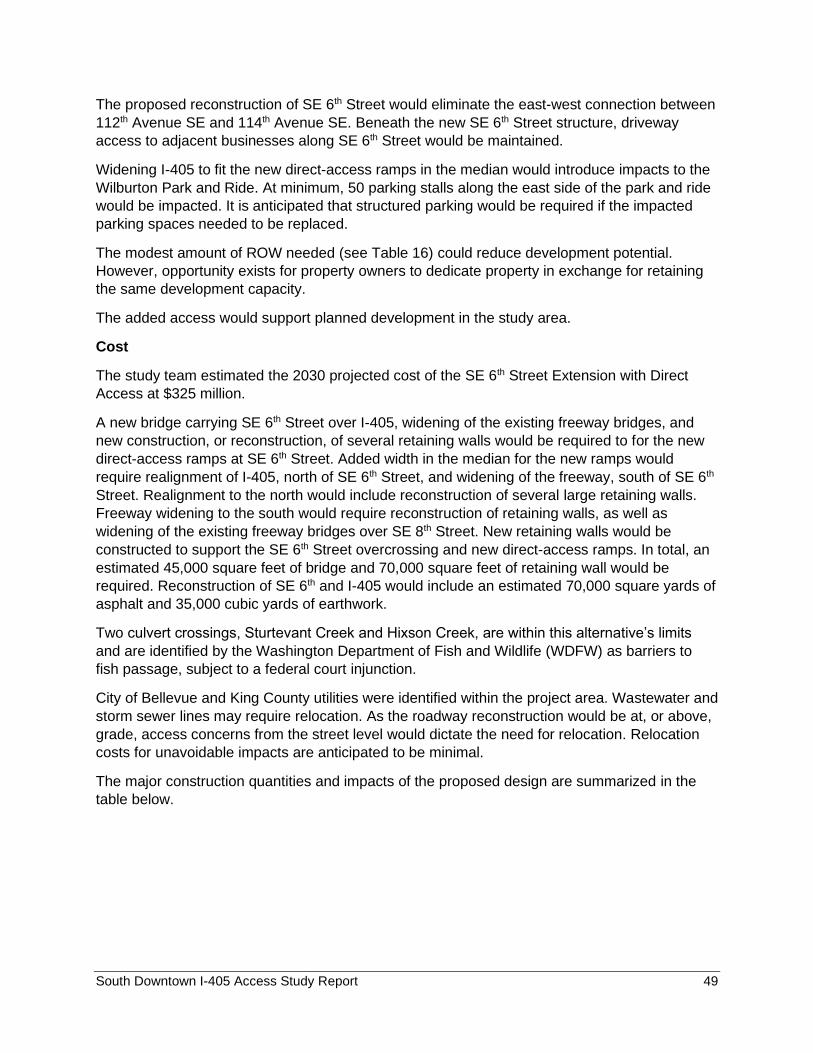
South Downtown I-405 Access Study Report 49
The proposed reconstruction of SE 6th Street would eliminate the east-west connection between
112th Avenue SE and 114th Avenue SE. Beneath the new SE 6th Street structure, driveway
access to adjacent businesses along SE 6th Street would be maintained.
Widening I-405 to fit the new direct-access ramps in the median would introduce impacts to the
Wilburton Park and Ride. At minimum, 50 parking stalls along the east side of the park and ride
would be impacted. It is anticipated that structured parking would be required if the impacted
parking spaces needed to be replaced.
The modest amount of ROW needed (see Table 16) could reduce development potential.
However, opportunity exists for property owners to dedicate property in exchange for retaining
the same development capacity.
The added access would support planned development in the study area.
Cost
The study team estimated the 2030 projected cost of the SE 6th Street Extension with Direct
Access at $325 million.
A new bridge carrying SE 6th Street over I-405, widening of the existing freeway bridges, and
new construction, or reconstruction, of several retaining walls would be required to for the new
direct-access ramps at SE 6th Street. Added width in the median for the new ramps would
require realignment of I-405, north of SE 6th Street, and widening of the freeway, south of SE 6th
Street. Realignment to the north would include reconstruction of several large retaining walls.
Freeway widening to the south would require reconstruction of retaining walls, as well as
widening of the existing freeway bridges over SE 8th Street. New retaining walls would be
constructed to support the SE 6th Street overcrossing and new direct-access ramps. In total, an
estimated 45,000 square feet of bridge and 70,000 square feet of retaining wall would be
required. Reconstruction of SE 6th and I-405 would include an estimated 70,000 square yards of
asphalt and 35,000 cubic yards of earthwork.
Two culvert crossings, Sturtevant Creek and Hixson Creek, are within this alternative’s limits
and are identified by the Washington Department of Fish and Wildlife (WDFW) as barriers to
fish passage, subject to a federal court injunction.
City of Bellevue and King County utilities were identified within the project area. Wastewater and
storm sewer lines may require relocation. As the roadway reconstruction would be at, or above,
grade, access concerns from the street level would dictate the need for relocation. Relocation
costs for unavoidable impacts are anticipated to be minimal.
The major construction quantities and impacts of the proposed design are summarized in the
table below.
South Downtown I-405 Access Study Report 50
Table 15 Major Construction Quantities and Impacts for SE 6th Street Extension with Direct Access Alternative
Construction Element Quantity / Impact
Earthwork 35,000 CY
Pavement 70,000 SY
Sidewalk 55,000 SF
Walls 70,000 SF
Bridge 45,000 SF
Right-of-way impact area (acres) 0.64 AC
Parcel Impacts 6 EA
NE 2nd Street Extension The concept design drawing for the NE 2nd Street Extension Alternative is in the following figure.
Figure 20 Concept Design for the NE 2nd Street Extension Alternative
Alignment with Adopted Plans and Policies
The existing Comprehensive Plan Comprehensive Transportation Project List includes the
extension of NE 2nd Street between 112th Ave NE and 116th Ave NE with access to I-405 to
and from south. This alternative includes the extension but without new access.
This alternative does not directly impact the adopted East Main TOD policies.
This alternative is expected to have permanent wetland and stream impacts that will require
mitigation.
This alternative does not have conflict with the planned light rail from Kirkland to Issaquah.
South Downtown I-405 Access Study Report 51
Access and Safety
A new motorized connection and crossing of I-405 would be provided between 112th Avenue
NE and 116th Avenue NE, increasing access to Downtown and the Bellevue Transit Center.
The proposed design would also include a new nonmotorized connection between 112th
Avenue NE and 116th Avenue NE. Short stretches of existing nonmotorized facilities along
112th Avenue NE, 114th Avenue NE, and 116th Avenue NE would be improved.
Properties along NE 2nd Street, between 112th Avenue NE and 114th Avenue NE, are in the
planning phase of redevelopment. Access to the north parcel is proposed off NE 2nd (project in
design review). A new NE 2nd Street bridge over I-405, and the approach roadway, would
eliminate access to adjacent sites in this block, and the redevelopment proposal would need to
be modified.
Due to increases in intersection delay and intersections added, a higher number of crashes
would be expected.
Impact on Property Development
Several significant property impacts were identified during the conceptual development of the
NE 2nd Street Extension. West of I-405, forty feet of additional width would be required to
accommodate a widened roadway and nonmotorized facilities. The widening would generate
roughly ½ acre of parcel impacts along NE 2nd Street. East of I-405, more than an acre of
private property, through environmentally sensitive areas, would need to be acquired.
NE 2nd Street would be raised to cross over 114th Avenue NE, the existing intersection of NE 2nd
Street and 114th Avenue NE would be closed, and an east-west connection between 112th
Avenue NE and 114th Avenue NE would be eliminated. Property access along the reconstructed
portion of NE 2nd Street would be eliminated. The elevated segment of the NE 2nd Street bridge
would also eliminate nonmotorized access to adjacent properties.
At 116th Avenue NE, commercial driveways would be relocated around the new NE 2nd Street
intersection. In some instances, required separation of the driveways from the new intersection
may not be achievable.
Right of way acquisition and access relocation would reduce the development potential of
impacted properties. However, opportunity exists for property owners to dedicate property in
exchange for retaining the same development capacity. Does not provide additional freeway
access capacity needed to support economic development vision.
Cost
The study team estimated the 2030 projected cost of the NE 2nd Street Extension at $125
million.
Property impacts in downtown Bellevue, especially for parcels with planned developments,
would be expensive and require lengthy negotiation to determine an agreed upon price.
Depending on the final roadway alignment for the project, full acquisition of some parcels may
be required.
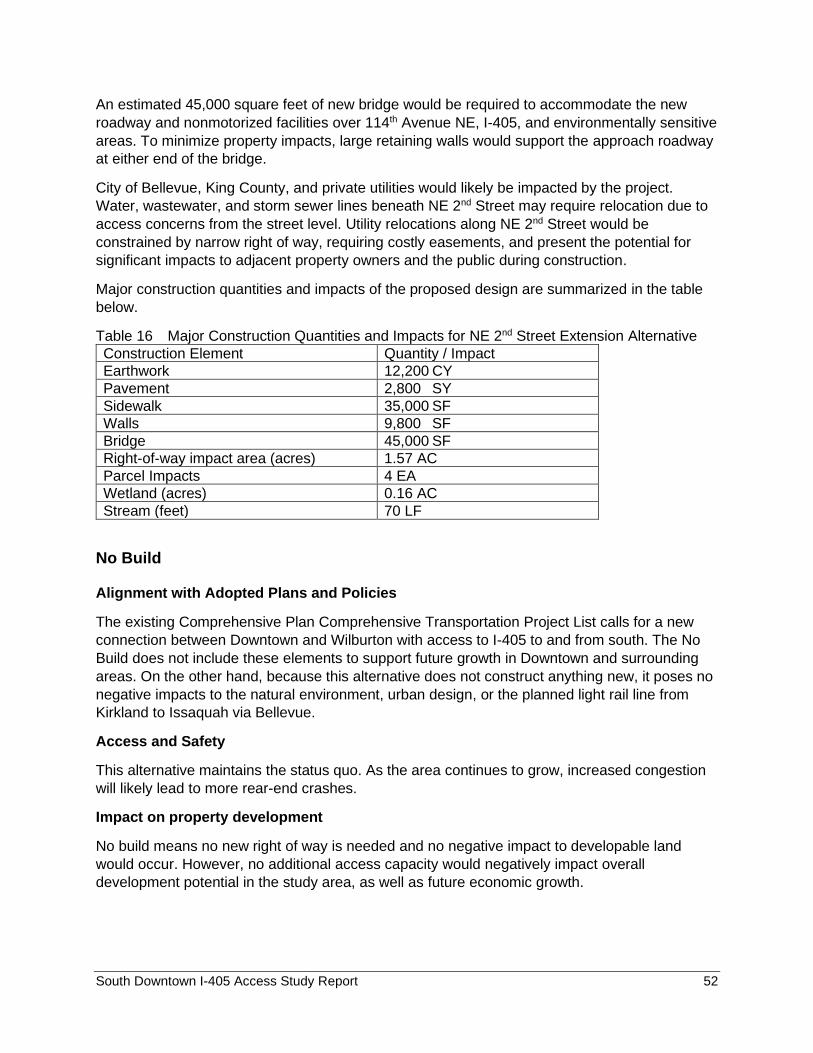
South Downtown I-405 Access Study Report 52
An estimated 45,000 square feet of new bridge would be required to accommodate the new
roadway and nonmotorized facilities over 114th Avenue NE, I-405, and environmentally sensitive
areas. To minimize property impacts, large retaining walls would support the approach roadway
at either end of the bridge.
City of Bellevue, King County, and private utilities would likely be impacted by the project.
Water, wastewater, and storm sewer lines beneath NE 2nd Street may require relocation due to
access concerns from the street level. Utility relocations along NE 2nd Street would be
constrained by narrow right of way, requiring costly easements, and present the potential for
significant impacts to adjacent property owners and the public during construction.
Major construction quantities and impacts of the proposed design are summarized in the table
below.
Table 16 Major Construction Quantities and Impacts for NE 2nd Street Extension Alternative
Construction Element Quantity / Impact
Earthwork 12,200 CY
Pavement 2,800 SY
Sidewalk 35,000 SF
Walls 9,800 SF
Bridge 45,000 SF
Right-of-way impact area (acres) 1.57 AC
Parcel Impacts 4 EA
Wetland (acres) 0.16 AC
Stream (feet) 70 LF
No Build
Alignment with Adopted Plans and Policies
The existing Comprehensive Plan Comprehensive Transportation Project List calls for a new
connection between Downtown and Wilburton with access to I-405 to and from south. The No
Build does not include these elements to support future growth in Downtown and surrounding
areas. On the other hand, because this alternative does not construct anything new, it poses no
negative impacts to the natural environment, urban design, or the planned light rail line from
Kirkland to Issaquah via Bellevue.
Access and Safety
This alternative maintains the status quo. As the area continues to grow, increased congestion
will likely lead to more rear-end crashes.
Impact on property development
No build means no new right of way is needed and no negative impact to developable land
would occur. However, no additional access capacity would negatively impact overall
development potential in the study area, as well as future economic growth.
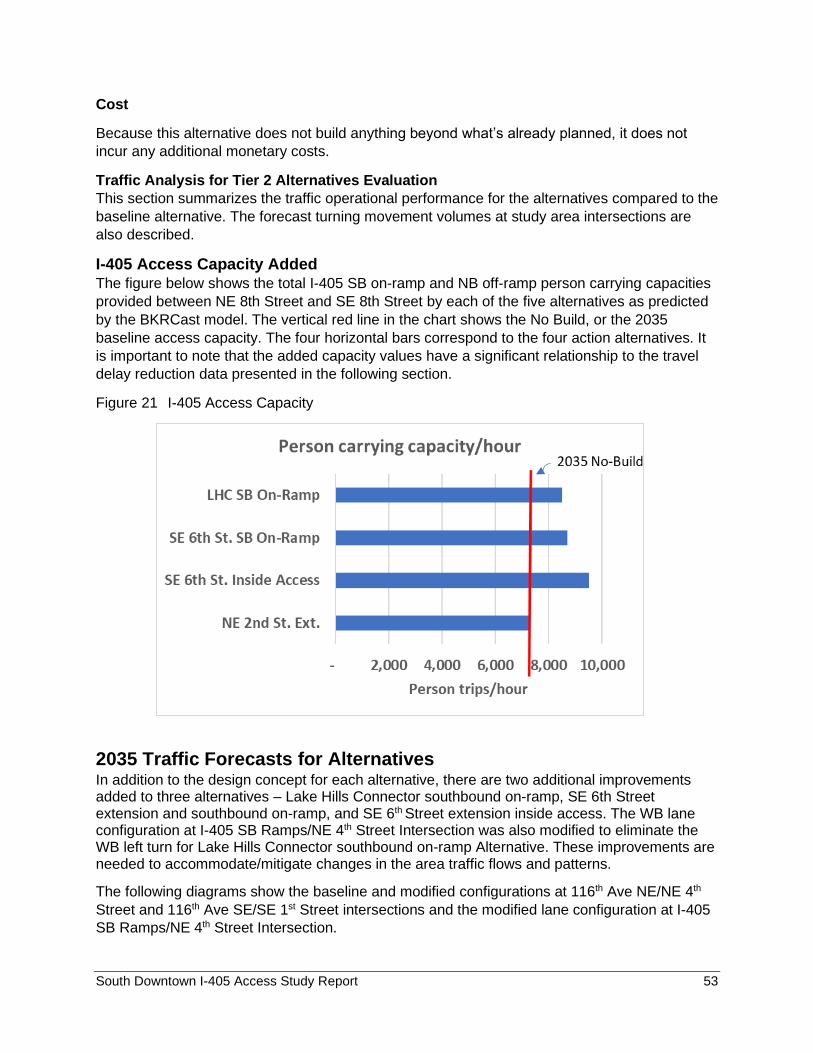
South Downtown I-405 Access Study Report 53
Cost
Because this alternative does not build anything beyond what’s already planned, it does not
incur any additional monetary costs.
Traffic Analysis for Tier 2 Alternatives Evaluation
This section summarizes the traffic operational performance for the alternatives compared to the
baseline alternative. The forecast turning movement volumes at study area intersections are
also described.
I-405 Access Capacity Added The figure below shows the total I-405 SB on-ramp and NB off-ramp person carrying capacities
provided between NE 8th Street and SE 8th Street by each of the five alternatives as predicted
by the BKRCast model. The vertical red line in the chart shows the No Build, or the 2035
baseline access capacity. The four horizontal bars correspond to the four action alternatives. It
is important to note that the added capacity values have a significant relationship to the travel
delay reduction data presented in the following section.
Figure 21 I-405 Access Capacity
2035 Traffic Forecasts for Alternatives In addition to the design concept for each alternative, there are two additional improvements added to three alternatives – Lake Hills Connector southbound on-ramp, SE 6th Street extension and southbound on-ramp, and SE 6th Street extension inside access. The WB lane configuration at I-405 SB Ramps/NE 4th Street Intersection was also modified to eliminate the WB left turn for Lake Hills Connector southbound on-ramp Alternative. These improvements are needed to accommodate/mitigate changes in the area traffic flows and patterns.
The following diagrams show the baseline and modified configurations at 116th Ave NE/NE 4th
Street and 116th Ave SE/SE 1st Street intersections and the modified lane configuration at I-405
SB Ramps/NE 4th Street Intersection.
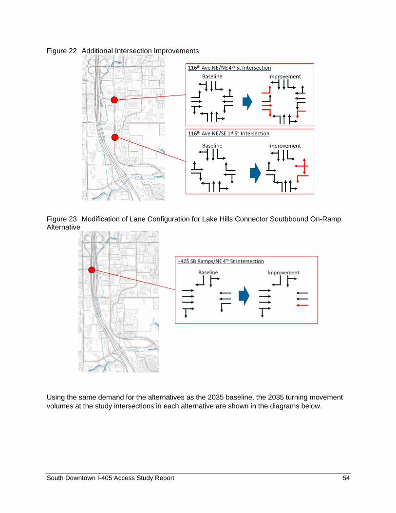
South Downtown I-405 Access Study Report 54
Figure 22 Additional Intersection Improvements
Figure 23 Modification of Lane Configuration for Lake Hills Connector Southbound On-Ramp Alternative
Using the same demand for the alternatives as the 2035 baseline, the 2035 turning movement
volumes at the study intersections in each alternative are shown in the diagrams below.
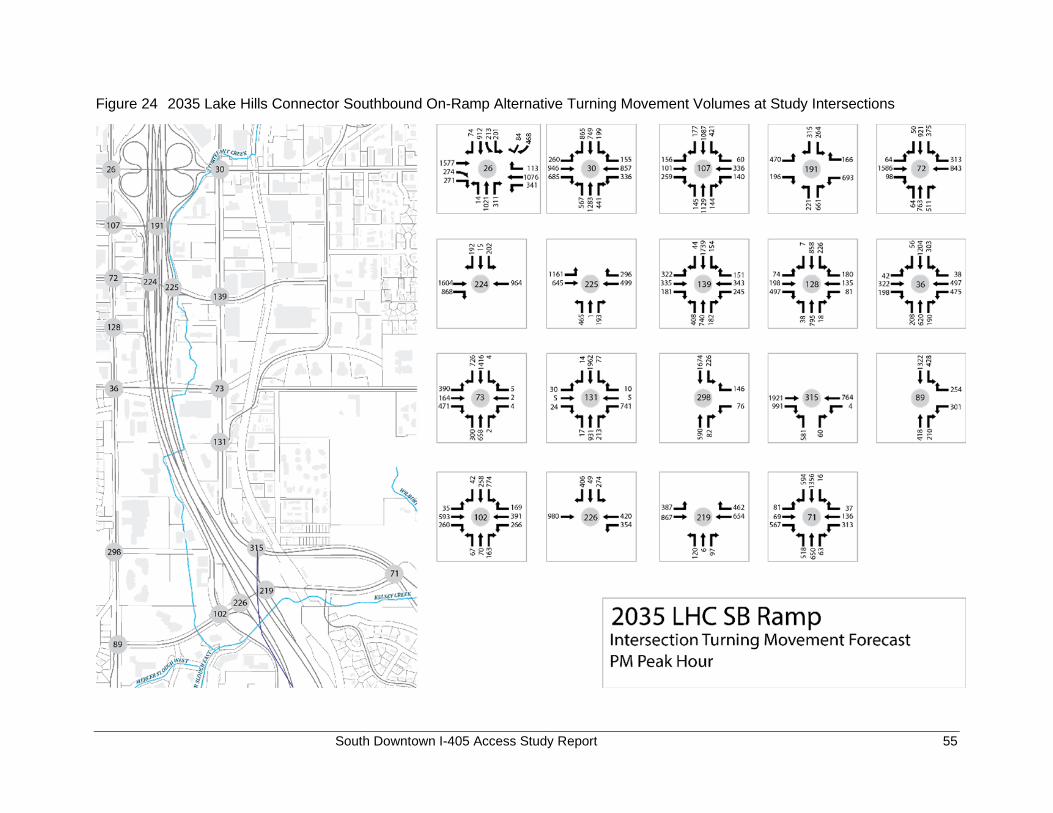
South Downtown I-405 Access Study Report 55
Figure 24 2035 Lake Hills Connector Southbound On-Ramp Alternative Turning Movement Volumes at Study Intersections
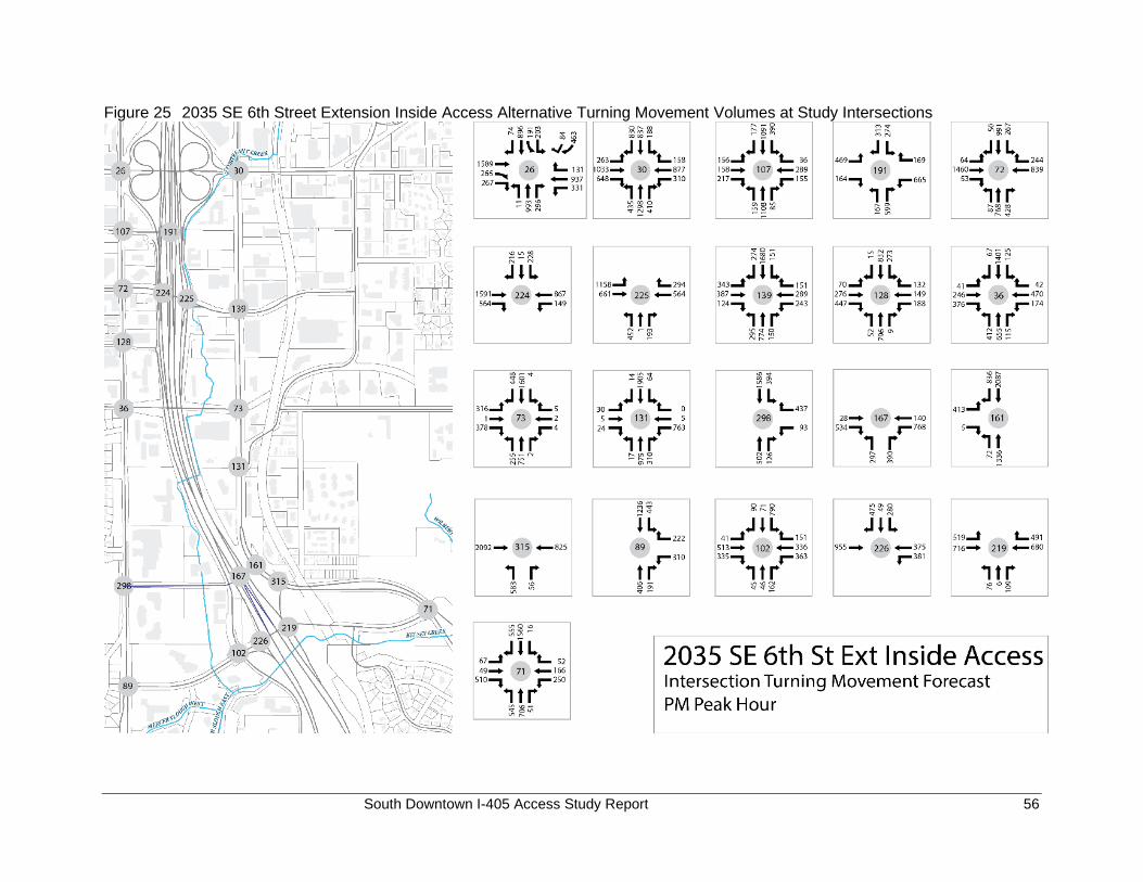
South Downtown I-405 Access Study Report 56
Figure 25 2035 SE 6th Street Extension Inside Access Alternative Turning Movement Volumes at Study Intersections
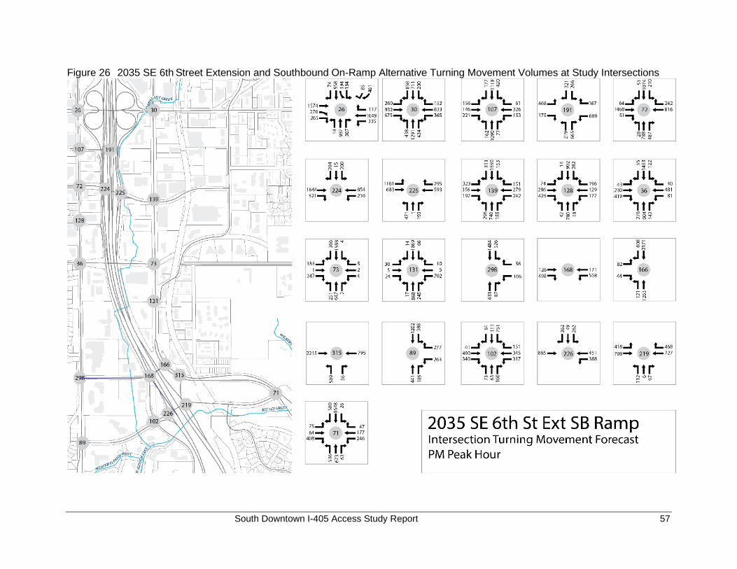
South Downtown I-405 Access Study Report 57
Figure 26 2035 SE 6th Street Extension and Southbound On-Ramp Alternative Turning Movement Volumes at Study Intersections
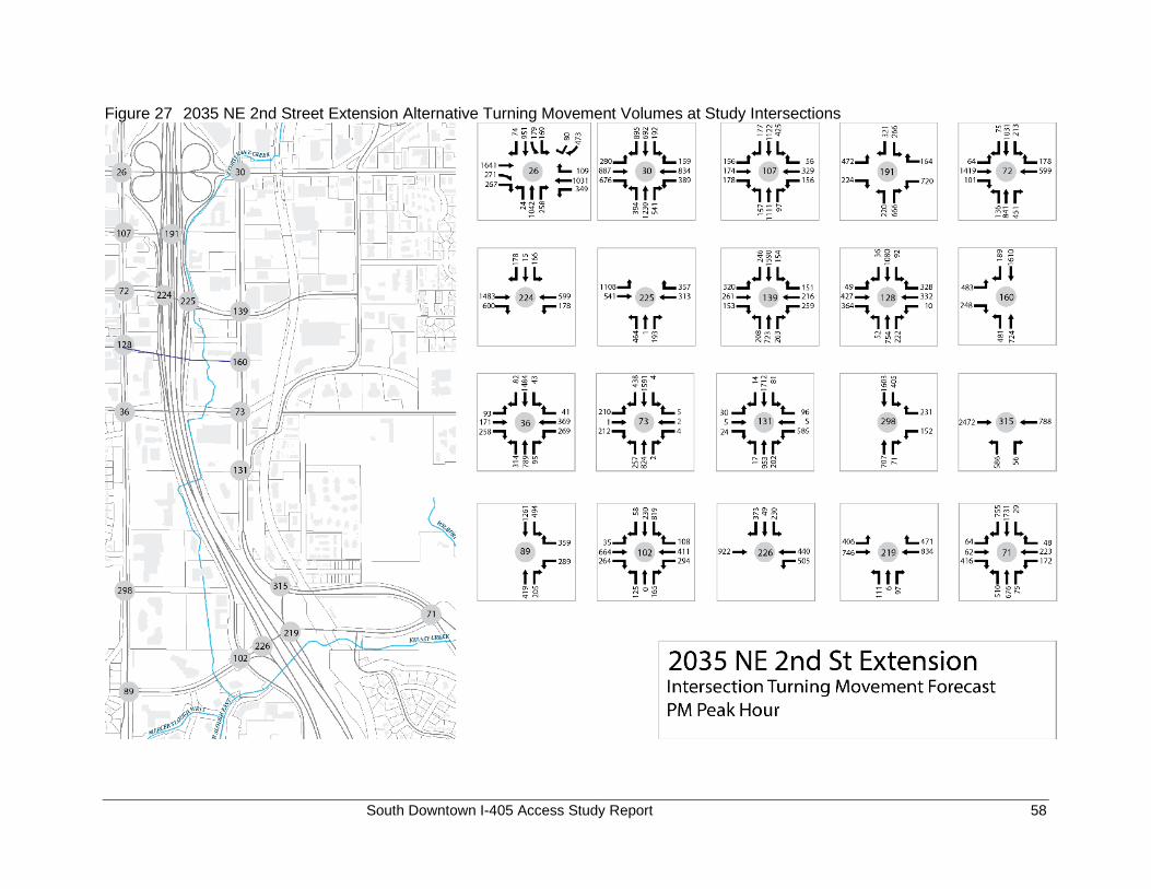
South Downtown I-405 Access Study Report 58
Figure 27 2035 NE 2nd Street Extension Alternative Turning Movement Volumes at Study Intersections
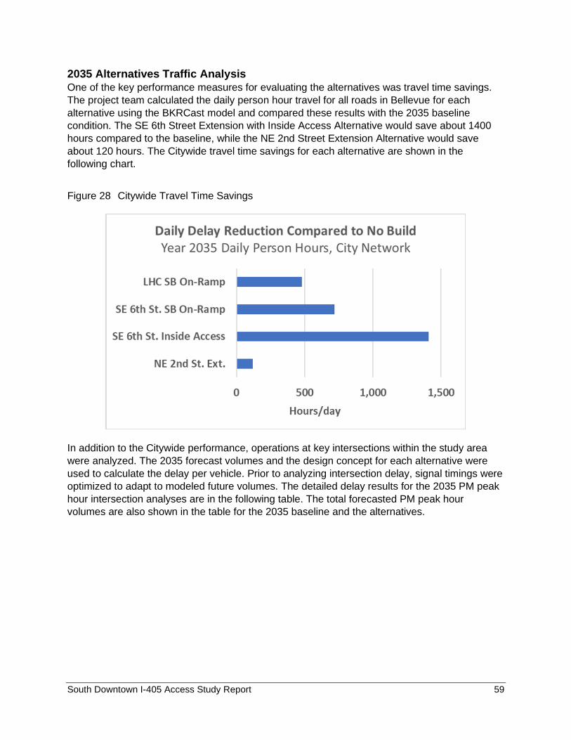
South Downtown I-405 Access Study Report 59
2035 Alternatives Traffic Analysis One of the key performance measures for evaluating the alternatives was travel time savings.
The project team calculated the daily person hour travel for all roads in Bellevue for each
alternative using the BKRCast model and compared these results with the 2035 baseline
condition. The SE 6th Street Extension with Inside Access Alternative would save about 1400
hours compared to the baseline, while the NE 2nd Street Extension Alternative would save
about 120 hours. The Citywide travel time savings for each alternative are shown in the
following chart.
Figure 28 Citywide Travel Time Savings
In addition to the Citywide performance, operations at key intersections within the study area
were analyzed. The 2035 forecast volumes and the design concept for each alternative were
used to calculate the delay per vehicle. Prior to analyzing intersection delay, signal timings were
optimized to adapt to modeled future volumes. The detailed delay results for the 2035 PM peak
hour intersection analyses are in the following table. The total forecasted PM peak hour
volumes are also shown in the table for the 2035 baseline and the alternatives.

South Downtown I-405 Access Study Report 60
Table 17 Comparison of 2035 PM Peak Hour Volumes and Delay for Study Intersections
NS Address EW AddressIntersection
Volume
Delay
(sec/veh)
Intersection
Volume
Delay
(sec/veh)
Intersection
Volume
Delay
(sec/veh)
Intersection
Volume
Delay
(sec/veh)
Intersection
Volume
Delay
(sec/veh)
26 112th Ave NE NE 8th St 6,997 133.5 6,950 125.6 6,874 121.7 6,731 122.6 6,918 132.8
30 116th Ave NE NE 8th St 7,321 67.6 7,343 77.6 7,149 59.5 7,287 59.8 7,169 58.6
107 112th Ave NE NE 6th St 4,135 53.9 4,155 55.4 4,108 53.2 4,021 51.1 4,138 56.0
191 I-405 HOV Ramps NE 6th St 3,051 67.7 2,986 64.4 2,970 63.2 2,820 57.6 3,053 67.2
72 112th Ave NE NE 4th St 5,306 33.6 5,588 36.3 5,279 34.1 5,251 34.1 5,108 40.9
224 I-405 SB Ramps NE 4th St 3,633 15.6 3,845 10.1 3,648 19.0 3,630 18.4 3,219 15.0
225 I-405 NB Ramps NE 4th St 3,345 28.0 3,260 27.0 3,397 30.5 3,323 22.4 2,977 21.4
139 116th Ave NE NE 4th St 4,739 86.0 4,844 78.0 4,755 71.6 4,861 77.1 4,544 69.4
128 112th Ave NE NE 2nd St 3,204 28.3 3,107 30.8 3,325 56.3 3,239 51.8 3,746 45.2
36 112th Ave Main St 4,066 64.9 4,153 79.9 3,946 50.7 4,124 78.0 4,008 67.0
73 116th Ave Main St 3,795 54.5 4,142 40.3 3,582 47.2 3,767 27.8 3,550 38.9
131 116th Ave SE SE 1st St 3,636 67.4 4,029 38.8 3,855 40.7 4,112 37.7 3,723 64.1
315 I-405 Off-ramp Lake Hills Connector 3,880 25.6 4,321 19.5 3,655 21.2 3,556 28.3 3,902 25.5
71 Lake Hills Connector SE 8th St 4,670 99.3 4,400 78.5 4,543 96.4 4,527 90.2 4,761 96.0
298 112th Ave SE SE 6th St 2,854 9.4 2,794 8.9 2,890 12.6 3,138 11.4 3,169 48.8
89 112th Ave SE SE 8th St 2,979 22.2 2,933 20.6 2,760 20.5 2,808 23.7 3,027 22.2
102 118th Ave SE SE 8th St 3,171 87.3 3,088 84.9 2,903 76.9 2,943 68.4 3,173 82.2
226 I-405 SB Ramps SE 8th St 2,481 46.3 2,483 30.3 2,377 25.0 2,515 21.9 2,519 41.5
219 I-405 NB Off- and On-ramps SE 8th St 2,626 18.5 2,593 14.8 2,537 18.8 2,597 19.5 2,671 20.6
160 116th Ave NE 2nd St - - - - - - 3,735 98.4
161 116th Ave SE 6th St - - - - 4,749 23.2 - -
167 I-405 Direct Access Ramps SE 6th St - - - - 2,157 42.7 - -
166 116th Ave SE 6th St - - 4,289 7.4 - - - -
168 I-405 SB GP On-ramp SE 6th St - - 1,353 16.2 - - - -
SE 6th St Extension
Inside AccessNE 2nd St Extension
Int ID
Cross StreetsLake Hills Connector
SB Ramp
SE 6th St Extension
SB Ramp2035 Baseline
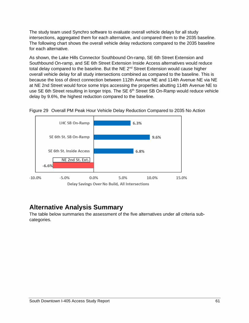
South Downtown I-405 Access Study Report 61
The study team used Synchro software to evaluate overall vehicle delays for all study
intersections, aggregated them for each alternative, and compared them to the 2035 baseline.
The following chart shows the overall vehicle delay reductions compared to the 2035 baseline
for each alternative.
As shown, the Lake Hills Connector Southbound On-ramp, SE 6th Street Extension and
Southbound On-ramp, and SE 6th Street Extension Inside Access alternatives would reduce
total delay compared to the baseline. But the NE 2nd Street Extension would cause higher
overall vehicle delay for all study intersections combined as compared to the baseline. This is
because the loss of direct connection between 112th Avenue NE and 114th Avenue NE via NE
at NE 2nd Street would force some trips accessing the properties abutting 114th Avenue NE to
use SE 6th Street resulting in longer trips. The SE 6th Street SB On-Ramp would reduce vehicle
delay by 9.6%, the highest reduction compared to the baseline.
Figure 29 Overall PM Peak Hour Vehicle Delay Reduction Compared to 2035 No Action
Alternative Analysis Summary The table below summaries the assessment of the five alternatives under all criteria sub-
categories.
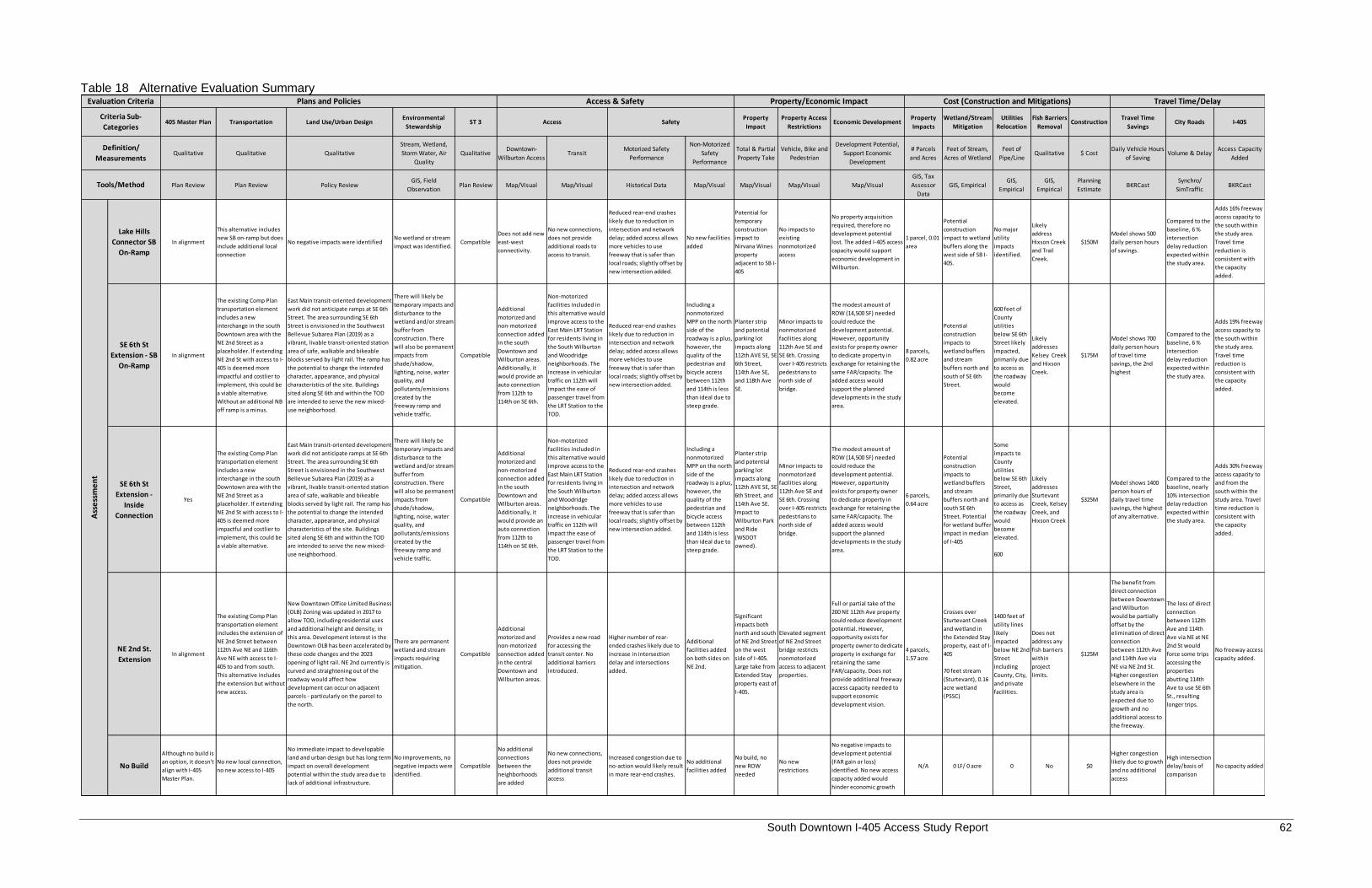
South Downtown I-405 Access Study Report 62
Table 18 Alternative Evaluation Summary
405 Master Plan Transportation Land Use/Urban DesignEnvironmental
StewardshipST 3
Property
Impact
Property Access
RestrictionsEconomic Development
Property
Impacts
Wetland/Stream
Mitigation
Utilities
Relocation
Fish Barriers
RemovalConstruction
Travel Time
SavingsCity Roads I-405
Qualitative Qualitative Qualitative
Stream, Wetland,
Storm Water, Air
Quality
QualitativeDowntown-
Wilburton AccessTransit
Motorized Safety
Performance
Non-Motorized
Safety
Performance
Total & Partial
Property Take
Vehicle, Bike and
Pedestrian
Development Potential,
Support Economic
Development
# Parcels
and Acres
Feet of Stream,
Acres of Wetland
Feet of
Pipe/LineQualitative $ Cost
Daily Vehicle Hours
of SavingVolume & Delay
Access Capacity
Added
Plan Review Plan Review Policy ReviewGIS, Field
ObservationPlan Review Map/Visual Map/Visual Historical Data Map/Visual Map/Visual Map/Visual Map/Visual
GIS, Tax
Assessor
Data
GIS, EmpiricalGIS,
Empirical
GIS,
Empirical
Planning
EstimateBKRCast
Synchro/
SimTrafficBKRCast
Lake Hills
Connector SB
On-Ramp
In alignment
This alternative includes
new SB on-ramp but does
include additional local
connection
No negative impacts were identifiedNo wetland or stream
impact was identified.Compatible
Does not add new
east-west
connectivity.
No new connections,
does not provide
additional roads to
access to transit.
Reduced rear-end crashes
likely due to reduction in
intersection and network
delay; added access allows
more vehicles to use
freeway that is safer than
local roads; slightly offset by
new intersection added.
No new facilities
added
Potential for
temporary
construction
impact to
Nirvana Wines
property
adjacent to SB I-
405
No impacts to
existing
nonmotorized
access
No property acquisition
required, therefore no
development potential
lost. The added I-405 access
capacity would support
economic development in
Wilburton.
1 parcel, 0.01
area
Potential
construction
impact to wetland
buffers along the
west side of SB I-
405.
No major
utility
impacts
identified.
Likely
address
Hixson Creek
and Trail
Creek.
$150M
Model shows 500
daily person hours
of savings.
Compared to the
baseline, 6 %
intersection
delay reduction
expected within
the study area.
Adds 16% freeway
access capacity to
the south within
the study area.
Travel time
reduction is
consistent with
the capacity
added.
SE 6th St
Extension - SB
On-Ramp
In alignment
The existing Comp Plan
transportation element
includes a new
interchange in the south
Downtown area with the
NE 2nd Street as a
placeholder. If extending
NE 2nd St with access to I-
405 is deemed more
impactful and costlier to
implement, this could be
a viable alternative.
Without an additional NB
off ramp is a minus.
East Main transit-oriented development
work did not anticipate ramps at SE 6th
Street. The area surrounding SE 6th
Street is envisioned in the Southwest
Bellevue Subarea Plan (2019) as a
vibrant, livable transit-oriented station
area of safe, walkable and bikeable
blocks served by light rail. The ramp has
the potential to change the intended
character, appearance, and physical
characteristics of the site. Buildings
sited along SE 6th and within the TOD
are intended to serve the new mixed-
use neighborhood.
There will likely be
temporary impacts and
disturbance to the
wetland and/or stream
buffer from
construction. There
will also be permanent
impacts from
shade/shadow,
lighting, noise, water
quality, and
pollutants/emissions
created by the
freeway ramp and
vehicle traffic.
Compatible
Additional
motorized and
non-motorized
connection added
in the south
Downtown and
Wilburton areas.
Additionally, it
would provide an
auto connection
from 112th to
114th on SE 6th.
Non-motorized
facilities included in
this alternative would
improve access to the
East Main LRT Station
for residents living in
the South Wilburton
and Woodridge
neighborhoods. The
increase in vehicular
traffic on 112th will
impact the ease of
passenger travel from
the LRT Station to the
TOD.
Reduced rear-end crashes
likely due to reduction in
intersection and network
delay; added access allows
more vehicles to use
freeway that is safer than
local roads; slightly offset by
new intersection added.
Including a
nonmotorized
MPP on the north
side of the
roadway is a plus,
however, the
quality of the
pedestrian and
bicycle access
between 112th
and 114th is less
than ideal due to
steep grade.
Planter strip
and potential
parking lot
impacts along
112th AVE SE, SE
6th Street,
114th Ave SE,
and 118th Ave
SE.
Minor impacts to
nonmotorized
facilities along
112th Ave SE and
SE 6th. Crossing
over I-405 restricts
pedestrians to
north side of
bridge.
The modest amount of
ROW (14,500 SF) needed
could reduce the
development potential.
However, opportunity
exists for property owner
to dedicate property in
exchange for retaining the
same FAR/capacity. The
added access would
support the planned
developments in the study
area.
8 parcels,
0.82 acre
Potential
construction
impacts to
wetland buffers
and stream
buffers north and
south of SE 6th
Street.
600 feet of
County
utilities
below SE 6th
Street likely
impacted,
primarily due
to access as
the roadway
would
become
elevated.
Likely
addresses
Kelsey Creek
and Hixson
Creek.
$175M
Model shows 700
daily person hours
of travel time
savings, the 2nd
highest
Compared to the
baseline, 6 %
intersection
delay reduction
expected within
the study area.
Adds 19% freeway
access capacity to
the south within
the study area.
Travel time
reduction is
consistent with
the capacity
added.
SE 6th St
Extension -
Inside
Connection
Yes
The existing Comp Plan
transportation element
includes a new
interchange in the south
Downtown area with the
NE 2nd Street as a
placeholder. If extending
NE 2nd St with access to I-
405 is deemed more
impactful and costlier to
implement, this could be
a viable alternative.
East Main transit-oriented development
work did not anticipate ramps at SE 6th
Street. The area surrounding SE 6th
Street is envisioned in the Southwest
Bellevue Subarea Plan (2019) as a
vibrant, livable transit-oriented station
area of safe, walkable and bikeable
blocks served by light rail. The ramp has
the potential to change the intended
character, appearance, and physical
characteristics of the site. Buildings
sited along SE 6th and within the TOD
are intended to serve the new mixed-
use neighborhood.
There will likely be
temporary impacts and
disturbance to the
wetland and/or stream
buffer from
construction. There
will also be permanent
impacts from
shade/shadow,
lighting, noise, water
quality, and
pollutants/emissions
created by the
freeway ramp and
vehicle traffic.
Compatible
Additional
motorized and
non-motorized
connection added
in the south
Downtown and
Wilburton areas.
Additionally, it
would provide an
auto connection
from 112th to
114th on SE 6th.
Non-motorized
facilities included in
this alternative would
improve access to the
East Main LRT Station
for residents living in
the South Wilburton
and Woodridge
neighborhoods. The
increase in vehicular
traffic on 112th will
impact the ease of
passenger travel from
the LRT Station to the
TOD.
Reduced rear-end crashes
likely due to reduction in
intersection and network
delay; added access allows
more vehicles to use
freeway that is safer than
local roads; slightly offset by
new intersection added.
Including a
nonmotorized
MPP on the north
side of the
roadway is a plus,
however, the
quality of the
pedestrian and
bicycle access
between 112th
and 114th is less
than ideal due to
steep grade.
Planter strip
and potential
parking lot
impacts along
112th AVE SE, SE
6th Street, and
114th Ave SE.
Impact to
Wilburton Park
and Ride
(WSDOT
owned).
Minor impacts to
nonmotorized
facilities along
112th Ave SE and
SE 6th. Crossing
over I-405 restricts
pedestrians to
north side of
bridge.
The modest amount of
ROW (14,500 SF) needed
could reduce the
development potential.
However, opportunity
exists for property owner
to dedicate property in
exchange for retaining the
same FAR/capacity. The
added access would
support the planned
developments in the study
area.
6 parcels,
0.64 acre
Potential
construction
impacts to
wetland buffers
and stream
buffers north and
south SE 6th
Street. Potential
for wetland buffer
impact in median
of I-405
Some
impacts to
County
utilities
below SE 6th
Street,
primarily due
to access as
the roadway
would
become
elevated.
600
Likely
addresses
Sturtevant
Creek, Kelsey
Creek, and
Hixson Creek
$325M
Model shows 1400
person hours of
daily travel time
savings, the highest
of any alternative.
Compared to the
baseline, nearly
10% intersection
delay reduction
expected within
the study area.
Adds 30% freeway
access capacity to
and from the
south within the
study area. Travel
time reduction is
consistent with
the capacity
added.
NE 2nd St.
ExtensionIn alignment
The existing Comp Plan
transportation element
includes the extension of
NE 2nd Street between
112th Ave NE and 116th
Ave NE with access to I-
405 to and from south.
This alternative includes
the extension but without
new access.
New Downtown Office Limited Business
(OLB) Zoning was updated in 2017 to
allow TOD, including residential uses
and additional height and density, in
this area. Development interest in the
Downtown OLB has been accelerated by
these code changes and the 2023
opening of light rail. NE 2nd currently is
curved and straightening out of the
roadway would affect how
development can occur on adjacent
parcels - particularly on the parcel to
the north.
There are permanent
wetland and stream
impacts requiring
mitigation.
Compatible
Additional
motorized and
non-motorized
connection added
in the central
Downtown and
Wilburton areas.
Provides a new road
for accessing the
transit center. No
additional barriers
introduced.
Higher number of rear-
ended crashes likely due to
increase in intersection
delay and intersections
added.
Additional
facilities added
on both sides on
NE 2nd.
Significant
impacts both
north and south
of NE 2nd Street
on the west
side of I-405.
Large take from
Extended Stay
property east of
I-405.
Elevated segment
of NE 2nd Street
bridge restricts
nonmotorized
access to adjacent
properties.
Full or partial take of the
200 NE 112th Ave property
could reduce development
potential. However,
opportunity exists for
property owner to dedicate
property in exchange for
retaining the same
FAR/capacity. Does not
provide additional freeway
access capacity needed to
support economic
development vision.
4 parcels,
1.57 acre
Crosses over
Sturtevant Creek
and wetland in
the Extended Stay
property, east of I-
405
70 feet stream
(Sturtevant), 0.16
acre wetland
(PSSC)
1400 feet of
utility lines
likely
impacted
below NE 2nd
Street
including
County, City,
and private
facilities.
Does not
address any
fish barriers
within
project
limits.
$125M
The benefit from
direct connection
between Downtown
and Wilburton
would be partially
offset by the
elimination of direct
connection
between 112th Ave
and 114th Ave via
NE via NE 2nd St.
Higher congestion
elsewhere in the
study area is
expected due to
growth and no
additional access to
the freeway.
The loss of direct
connection
between 112th
Ave and 114th
Ave via NE at NE
2nd St would
force some trips
accessing the
properties
abutting 114th
Ave to use SE 6th
St., resulting
longer trips.
No freeway access
capacity added.
No Build
Although no build is
an option, it doesn't
align with I-405
Master Plan.
No new local connection,
no new access to I-405
No immediate impact to developable
land and urban design but has long term
impact on overall development
potential within the study area due to
lack of additional infrastructure.
No improvements, no
negative impacts were
identified.
Compatible
No additional
connections
between the
neighborhoods
are added
No new connections,
does not provide
additional transit
access
Increased congestion due to
no-action would likely result
in more rear-end crashes.
No additional
facilities added
No build, no
new ROW
needed
No new
restrictions
No negative impacts to
development potential
(FAR gain or loss)
identified. No new access
capacity added would
hinder economic growth
N/A 0 LF/ 0 acre 0 No $0
Higher congestion
likely due to growth
and no additional
access
High intersection
delay/basis of
comparison
No capacity added
Travel Time/DelayAccess & Safety
Criteria Sub-
CategoriesAccess Safety
Property/Economic Impact Cost (Construction and Mitigations)A
sse
ssm
en
tEvaluation Criteria Plans and Policies
Definition/
Measurements
Tools/Method
South Downtown I-405 Access Study Report 63
Community Input The project study team, with the support of consultant PRR Inc, carried out a robust community
engagement process using several online venues compliant with COVID-19 requirements. The
process included four stakeholder forums, two public open houses, and a series of meetings
with individual stakeholders and interest groups.
Stakeholder feedback
At the fourth stakeholder forum, the study team shared Tier 2 analysis results and conducted
post forum opinion polls. Below is a list of major themes from the input received from
stakeholders.
• Broad support for all three alternatives with added access, including Lake Hills
Connector Southbound On-Ramp, and the two SE 6th Street Extension alternatives
• Property owners adjacent to SE 6th Street voiced strong concerns about the two
extension alternatives’ impact to their properties and access
• Few supported the NE 2nd Street Extension
• No Build alternative is unacceptable
Interest Group Feedback
The study team provided briefings to key interest groups including Bellevue Chamber of
Commerce, Bellevue Downtown Association (BDA), and Eastside Transportation Association
(ETA). Following the final briefings with Tier 2 study information, each of the three boards
developed and presented recommendations to the City Council for their consideration.
• Lake Hills Connector SB On-Ramp is among the recommendations of all three boards.
• BDA also recommends SE 6th Street SB On-Ramp contingent on adoption of the East
Main Land Use Code by fall this year.
• ETA additionally recommends implementing the SB auxiliary lane immediately and
keeping the NE 2nd Street extension option open for future consideration.
Public Input
The study team hosted two public online open houses. The first open house was launched in
early August 2020 and lasted three weeks. It introduced the South Downtown I-405 Access
Study to the public and asked for feedback on seven transportation improvement options that
passed an initial fatal flaw screening. The second online open house launched in mid-February
2021 and lasted for two weeks. It shared detailed analysis findings of five options.
The study team received over 350 comments from both virtual open houses (combined). Below
are the key findings:
• Support and concern expressed for each option studied by the City
• Support for improving I-405 access and reducing freeway merging and weaving
• Support for multimodal connections for pedestrians, bicyclists, and transit riders
• Concerns:
o Would not solve congestion on I-405.
o Would encourage vehicle travel, impact local streets, and contribute to climate
change.
South Downtown I-405 Access Study Report 64
o High cost and would divert resources from funding other high transportation
priorities.
• Some downtown residents suggested reconsidering the Main Street option. (Note: This
option did not pass the fatal flaw screening).
For more information regarding community engagement process and inputs received, please
see City of Bellevue/South Downtown I-405 Access Study Community Engagement Report.
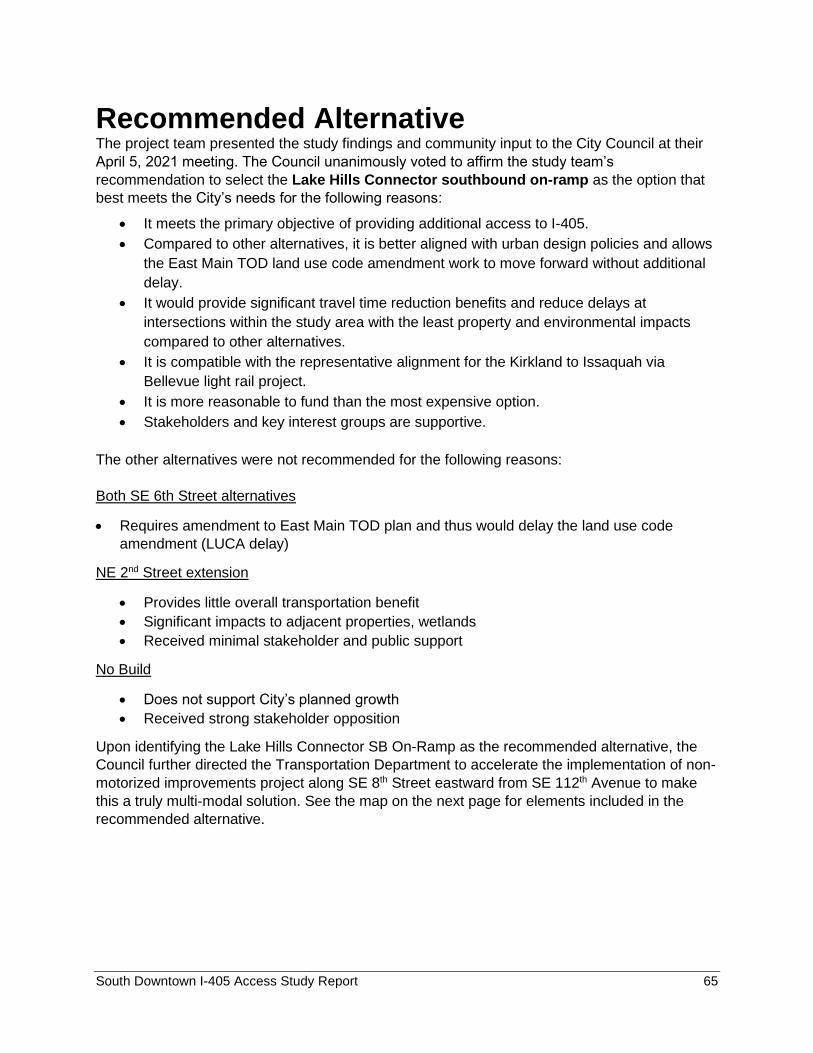
South Downtown I-405 Access Study Report 65
Recommended Alternative The project team presented the study findings and community input to the City Council at their
April 5, 2021 meeting. The Council unanimously voted to affirm the study team’s
recommendation to select the Lake Hills Connector southbound on-ramp as the option that
best meets the City’s needs for the following reasons:
• It meets the primary objective of providing additional access to I-405.
• Compared to other alternatives, it is better aligned with urban design policies and allows
the East Main TOD land use code amendment work to move forward without additional
delay.
• It would provide significant travel time reduction benefits and reduce delays at
intersections within the study area with the least property and environmental impacts
compared to other alternatives.
• It is compatible with the representative alignment for the Kirkland to Issaquah via
Bellevue light rail project.
• It is more reasonable to fund than the most expensive option.
• Stakeholders and key interest groups are supportive.
The other alternatives were not recommended for the following reasons:
Both SE 6th Street alternatives
• Requires amendment to East Main TOD plan and thus would delay the land use code
amendment (LUCA delay)
NE 2nd Street extension
• Provides little overall transportation benefit
• Significant impacts to adjacent properties, wetlands
• Received minimal stakeholder and public support
No Build
• Does not support City’s planned growth
• Received strong stakeholder opposition
Upon identifying the Lake Hills Connector SB On-Ramp as the recommended alternative, the
Council further directed the Transportation Department to accelerate the implementation of non-
motorized improvements project along SE 8th Street eastward from SE 112th Avenue to make
this a truly multi-modal solution. See the map on the next page for elements included in the
recommended alternative.
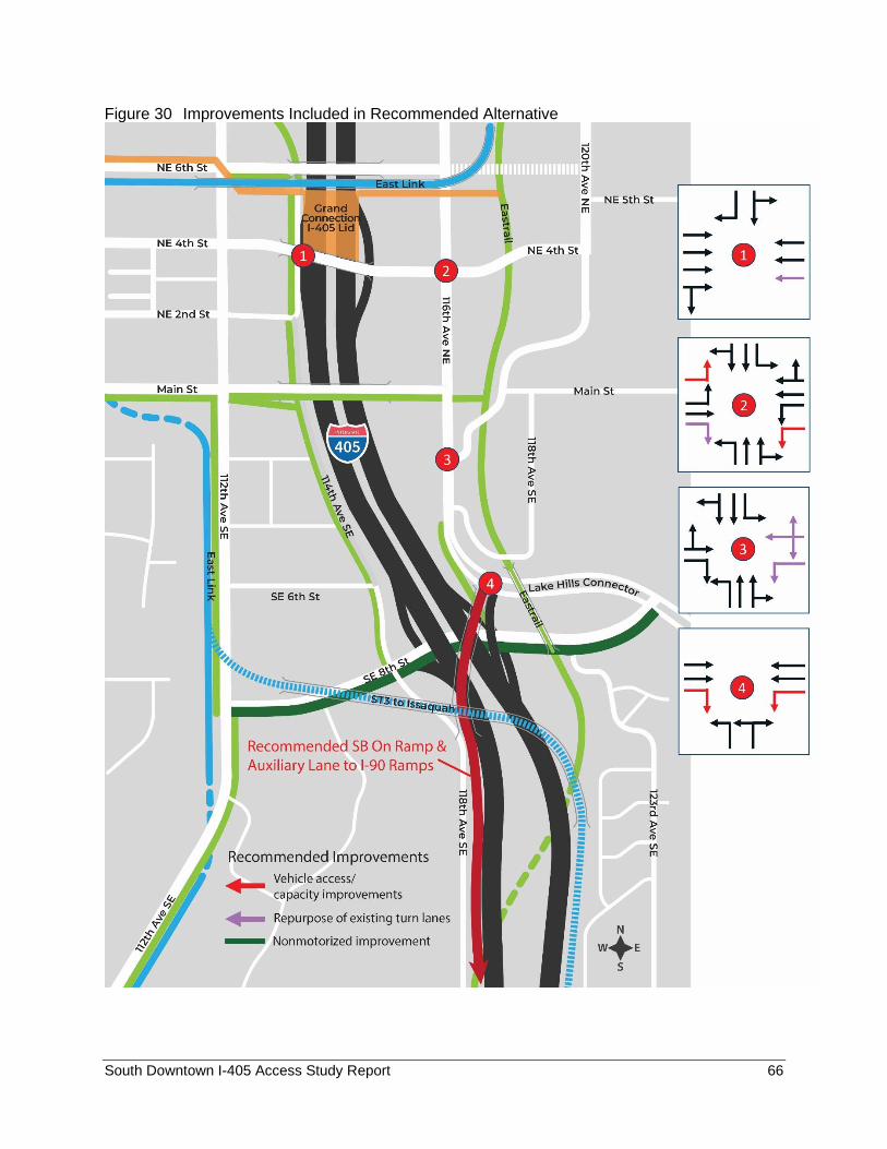
South Downtown I-405 Access Study Report 66
Figure 30 Improvements Included in Recommended Alternative
South Downtown I-405 Access Study Report 67
Next Steps The I-405 Access Study confirmed the need for additional access to South Downtown from I-
405 as identified in the I-405 Master Plan. The study identified the Lake Hills Connector
Southbound On-Ramp as the alternative that best meets City needs as measured by the project
purpose and need and the results of the evaluation of alternatives completed by the staff study
team. Because I-405 is an Interstate facility, FHWA has the ultimate authority to approve the
recommended access addition. The alternative identified in this study allows the project to begin
the environmental review and access revision request processes when funding is secured. This
study provides critical information to inform those future processes.


![Downtown Presentation DTI Civic River2Rail River South ... · Microsoft PowerPoint - Downtown Presentation DTI Civic_River2Rail_River South [Read-Only] Author: kwagers Created Date:](https://img.pdfslide.net/doc/110x75/5fde234ae286745b1860198d/downtown-presentation-dti-civic-river2rail-river-south-microsoft-powerpoint.jpg)