Embed Size (px)
Citation preview

Interstate 405 at Wilmington Avenue Improvement Project
LOS ANGELES COUNTY, CALIFORNIA DISTRICT 7 – LA – 405, PM 9.30/9.89
234000
Initial Study/Environmental Assessment with Mitigated Negative Declaration and Finding
of No Significant Impact
Prepared by City of Carson and State of California Department of Transportation
The environmental review, consultation, and any other action required in accordance with applicable Federal laws for this project is being, or has been, carried-out by
Caltrans under its assumption of responsibility pursuant to 23 U.S.C. 327.
November 2008


S - 1
SUMMARY
The proposed project is a joint project by California Department of Transportation (Caltrans) in corporation with the City of Carson and the Federal Highway Administration (FHWA) and is subject to state and federal environmental review requirements. Project documentation has been prepared in compliance with both the California Environmental Quality Act (CEQA) and the National Environmental Policy Act (NEPA). FHWA’s responsibility for environmental review, consultation, and any other action required in accordance with NEPA and other applicable Federal laws for this project is being carried out by Caltrans under its assumption of responsibility pursuant to 23 U.S.C. 327. Caltrans is the lead agency under CEQA and NEPA. Caltrans and the City of Carson (City) propose to widen the existing on- and off-ramps of Interstate 405 (I-405) & Wilmington Avenue interchange (interchange); add a new northbound (NB) on-ramp; and widen Wilmington Avenue and 223rd Street in the City of Carson, within the County of Los Angeles. These improvements are needed to alleviate the traffic congestion that occurs on Wilmington Avenue, on the I-405 ramps, and at the Wilmington Avenue/223rd Street intersection. The proposed project is located approximately 3.4 miles south of the I-405/I-110 interchange and 2.0 miles north of I-405 & I-710 interchange. The intersection of Wilmington Avenue/223rd Street is located approximately 500 feet south of the I-405/Wilmington Avenue interchange. Three Alternatives are being considered: the No-Build Alternative and two build alternatives, Alternative 1 and 2. Alternative 1 consists of widening the existing on- and off-ramps and modifying Wilmington Avenue and 223rd Street. Alternative 2 consists of adding a new NB on-ramp to I-405, in addition to the improvements associated with Alternative 1. Wilmington Avenue would be widened by converting the existing westerly and easterly sidewalks into through-lanes. The build alternatives require the acquisition of right-of-way, but no relocation of residence or businesses would be required. All partially and fully acquired properties will be treated in conformance with the federal Uniform Relocation and Real Property Acquisition Policy Act (or the “Uniform Relocation Act”). Some hazardous materials from past activities may have contaminated the project area. A site investigation is being conducted to identify if any excavated soil is contaminated. The findings of the site investigation will be used to determine the proper soil handling and disposal methods during the project construction. Specifications for the health and safety of the workers, as well as that of the public, will be addressed when handling/disposing of any contaminated soil. During the construction phase, a temporary closure of one driveway access point for the Chevron Gas Station, located at 22222 Wilmington Avenue, and the Shell Gas Station, located at 22232 Wilmington Avenue, would be required by Alternatives 1 and 2. At least

I-405 AT WILMINGTON AVENUE IMPROVEMENT PROJECT INITIAL STUDY/ENVIRONMENTAL ASSESSMENT
S - 2
one driveway access point to both gas stations would be maintained at all times during the construction period. There would be short-term (temporary) noise, dust, and access problems during the construction of the proposed project. Measures to minimize these impacts are discussed in this document. Since these construction-related impacts would not be permanent, they are considered below the level of significance as defined by CEQA.
Summary of Mitigation Measures
Environmental Category Impact Mitigation Measure
Community Impacts (including traffic and pedestrian use)
Construction impacts on businesses and the local community
• Develop a construction staging plan and TMP that identifies alternate detour routes, safe pedestrian routes, and residential and commercial access routes to be used during construction.
• Notify area residents, businesses, and any service/utility providers about the project construction schedule.
• Compensate property owners for the loss of land through the Caltrans right-of-way (ROW) appraisal process.
• Coordinate with Union Pacific Railroad (UPRR) Company Visual and Aesthetics
Soundwall construction • Maximize the use of landscape areas while following Caltrans standards. Reinforce a unified design theme compatible with the adjacent community.
Cultural Resources
Grading and excavation • If buried cultural materials are encountered during construction, work in that area must halt until a qualified archaeologist can evaluate the significance of the find.
• In the event human remains are encountered during project construction, the Los Angeles County Coroner shall be contacted to determine whether or not investigation of the cause of death is required. It the event the remains are Native American in origin, the Native American Heritage Commission shall be contacted to determine necessary procedures for protection and preservation of remains, including reburial, as provided in the CEQA Guidelines, Section 15064.5(e).
Hydrology/Water Quality/Stormwater
Construction in and over Dominguez Channel and potential for dewatering of contaminated groundwater
• The contractor shall develop a Storm Water Pollution Prevention Plan (SWPPP) and conform to the requirements of the Caltrans Standard Specifications to reduce impacts to water quality. The plan shall be approved by Caltrans prior to project construction and implementation.
• Install a groundwater monitoring well to test soils and groundwater quality.
Geology and Soils Potential seismic hazard
• Adhere to all applicable Caltrans seismic requirements.

I-405 AT WILMINGTON AVENUE IMPROVEMENT PROJECT INITIAL STUDY/ENVIRONMENTAL ASSESSMENT
S - 3
Summary of Mitigation Measures
Environmental Category Impact Mitigation Measure
Paleontology Ground disturbance may impact nonrenewable paleontological resources
• Excavation into previously undisturbed older subsurface sediments should be monitored by a qualified paleontological monitor.
Hazardous Materials/ Waste
Potential for encountering soil contamination, aerially deposit lead (ADL) in soil, or lead-based paint (LBP) coatings
• All contaminated soils shall be treated in conformance with the California Department of Toxic Substance Control (DTSC) regulations
• Specifications for the removal of asbestos, suspected meals coated with lead-based paint, and other hazardous substances, if encountered during construction, shall be included in the project.
• All litter and solid waste will be taken to an approved disposal facility.
Air Quality
Particulate emissions from construction activities
• The project will be required to comply with regional South Coast Air Quality Management District (SCAQMD) rules, which would assist in reducing short-term air pollutant emissions.
• Construction equipment shall be properly tuned and maintained in accordance with manufacturer’s specifications.
• During construction, trucks and vehicles in loading and unloading queues must be kept with their engines off when not in use to reduce vehicle emissions.
• Construction emissions shall be phased and scheduled to avoid emissions peaks, where feasible, and discontinued during second-stage smog alerts
Noise Elevated noise during construction and traffic noise during operation
• The City of Carson will notify the area businesses and residents of the construction schedule at least two weeks in advance of the construction and provide a telephone hotline for any complaints.
• The construction schedule will be arranged so that the soundwalls would be completed before the NB on-ramp construction to minimize construction noise impacts to the residences north of I-405 from ramp construction.
• All equipment shall have sound-control devices no less effective than those provided on the original equipment. No equipment shall have an unmuffled exhaust.
• As directed by the Caltrans resident engineer, the contractor shall implement appropriate additional noise abatement measures.

I-405 AT WILMINGTON AVENUE IMPROVEMENT PROJECT INITIAL STUDY/ENVIRONMENTAL ASSESSMENT
S - 4
Summary of Mitigation Measures
Environmental Category Impact Mitigation Measure
Biological Resources Tree removal impacts • When trees are removed, they will be replaced with trees of comparable size and canopy quality to attract nesting birds. Ground preparation and removal of any or all those trees should occur between September 1st and February 1st to minimize the chance of disturbing nesting birds protected by the Migratory Bird Treaty Act of 1918.
• If storm water BMPs are implemented at the interior of the NB loop-ramp area, the existing Cottonwood trees would be removed and replaced within the loop in commensurate numbers. Caltrans shall coordinate with the City of Carson to determine specific locations of replacement trees.
This Initial Study/Environmental Assessment has found that all environmental impacts can be mitigated to a point where a Mitigated Negative Declaration/Finding of No Significant Impact would be the appropriate determination.

I
CONTENTS
SUMMARY............................................................................................... S-1
CONTENTS ................................................................................................. I
1.0 PROPOSED PROJECT ...................................................................... 1 1.1 Introduction ........................................................................................................... 1 1.2 Purpose and Need................................................................................................. 2 1.3 Project Description ............................................................................................. 10 1.4 Alternatives Considered but Eliminated from Further Discussion ............. 19 1.5 Scheduling ............................................................................................................ 20 1.6 Other Projects...................................................................................................... 21 1.7 Permits and Approvals Needed ........................................................................ 22
2.0 AFFECTED ENVIRONMENT, ENVIRONMENTAL CONSEQUENCES, AND MITIGATION MEASURES....................................................... 23 2.1 Introduction ......................................................................................................... 23 2.2 Community Impacts ........................................................................................... 26 2.3 Traffic and Transportation/Pedestrian Facilities ........................................... 38 2.4 Visual and Aesthetic Effects.............................................................................. 43 2.5 Cultural Resources .............................................................................................. 57 2.6 Hydrology/Water Quality/Stormwater ........................................................... 61 2.7 Topography, Geology, Soils, and Seismicity ................................................... 68 2.8 Paleontology......................................................................................................... 74 2.9 Hazardous Materials/Waste .............................................................................. 76 2.10 Air Quality ............................................................................................................ 80 2.11 Noise ................................................................................................................... 112 2.12 Public Services ................................................................................................... 128 2.13 Biological Resources ......................................................................................... 130 2.14 Climate Change.................................................................................................. 135 2.15 Cumulative Impacts .......................................................................................... 137
3.0 CONSULTATION AND COORDINATION....................................... 139 3.1 Scoping ............................................................................................................... 139 3.2 Coordination ...................................................................................................... 140 3.3 Public Review of IS/EA .................................................................................. 140
4.0 LIST OF PREPARERS................................................................... 143
5.0 DISTRIBUTION LIST .................................................................... 145
6.0 REFERENCES............................................................................... 149

I-405 AT WILMINGTON AVENUE IMPROVEMENTS PROJECT INITIAL STUDY/ENVIRONMENTAL ASSESSMENT
I I
APPENDIXES A CEQA Checklist B Notice of Initiation of Studies (NOIS) and Newspaper Advertisement for Open
House C Open House Meeting Notes and Comments Received D Notice of Availability and Notice of Public Hearing Opportunity E Response to Comments Received for the Draft IS/EA F Title VI Policy Statement G Minimization and Mitigation Summary H Acronyms and Abbreviations I Mitigation Monitoring and Reporting Program J FHWA Air Quality Conformity Determination
I-405 AT WILMINGTON AVENUE IMPROVEMENT PROJECT INITIAL STUDY/ENVIRONMENTAL ASSESSMENT
I I I
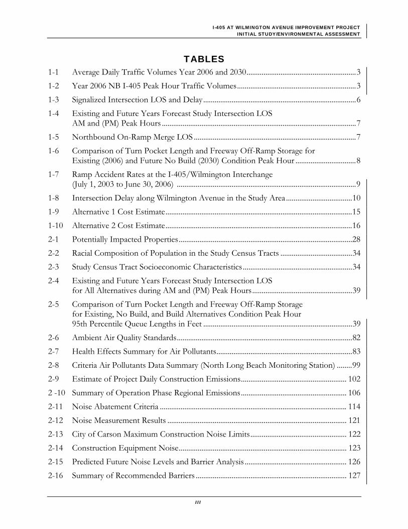
TABLES 1-1 Average Daily Traffic Volumes Year 2006 and 2030..........................................................3 1-2 Year 2006 NB I-405 Peak Hour Traffic Volumes...............................................................3 1-3 Signalized Intersection LOS and Delay.................................................................................6 1-4 Existing and Future Years Forecast Study Intersection LOS
AM and (PM) Peak Hours .......................................................................................................7 1-5 Northbound On-Ramp Merge LOS ......................................................................................7 1-6 Comparison of Turn Pocket Length and Freeway Off-Ramp Storage for
Existing (2006) and Future No Build (2030) Condition Peak Hour ................................8 1-7 Ramp Accident Rates at the I-405/Wilmington Interchange
(July 1, 2003 to June 30, 2006) ...............................................................................................9 1-8 Intersection Delay along Wilmington Avenue in the Study Area ...................................10 1-9 Alternative 1 Cost Estimate...................................................................................................15 1-10 Alternative 2 Cost Estimate...................................................................................................16 2-1 Potentially Impacted Properties............................................................................................28 2-2 Racial Composition of Population in the Study Census Tracts ......................................34 2-3 Study Census Tract Socioeconomic Characteristics..........................................................34 2-4 Existing and Future Years Forecast Study Intersection LOS
for All Alternatives during AM and (PM) Peak Hours.....................................................39 2-5 Comparison of Turn Pocket Length and Freeway Off-Ramp Storage
for Existing, No Build, and Build Alternatives Condition Peak Hour 95th Percentile Queue Lengths in Feet ...............................................................................39
2-6 Ambient Air Quality Standards.............................................................................................82 2-7 Health Effects Summary for Air Pollutants........................................................................83 2-8 Criteria Air Pollutants Data Summary (North Long Beach Monitoring Station) ........99 2-9 Estimate of Project Daily Construction Emissions........................................................ 102 2 -10 Summary of Operation Phase Regional Emissions........................................................ 106 2-11 Noise Abatement Criteria ................................................................................................... 114 2-12 Noise Measurement Results ............................................................................................... 121 2-13 City of Carson Maximum Construction Noise Limits................................................... 122 2-14 Construction Equipment Noise......................................................................................... 123 2-15 Predicted Future Noise Levels and Barrier Analysis ...................................................... 126 2-16 Summary of Recommended Barriers ................................................................................ 127

I-405 AT WILMINGTON AVENUE IMPROVEMENTS PROJECT INITIAL STUDY/ENVIRONMENTAL ASSESSMENT
I V
FIGURES 1-1 Project Location and Vicinity Map ........................................................................................1 1-2 Existing Intersection Configuration.......................................................................................4 1-3 Existing (2006) Peak Hour Traffic Volume..........................................................................5 1-4 Aerial View of Proposed Improvements ............................................................................13 1-5 Alternative 1 Lane Configuration .........................................................................................17 1-6 Alternative 2 Lane Configuration .........................................................................................18 2-1 Potentially Impacted Properties............................................................................................31 2-2 Alternative 1 Year 2030 Peak Hour Traffic Volumes.......................................................40 2-3 Alternative 2 Year 2030 Peak Hour Traffic Volumes.......................................................41 2-4 Aerial View of the Project Area ............................................................................................44 2-5 Residential Landscape Unit ...................................................................................................47 2-6 Commercial Landscape Unit .................................................................................................49 2-7 I-405 Landscape Unit .............................................................................................................51 2-8 Proposed View of NB On-Ramp with Soundwalls (view looking north
over the interchange) ..............................................................................................................55 2-9 Proposed View of NB On-Ramp with Soundwalls (view looking west from
the neighborhood)...................................................................................................................55 2-10 Typical A-Weighted Sound Levels .................................................................................... 116 2-11 Sensitive Receptors and Noise Measurement Locations............................................... 119

1
1.0 PROPOSED PROJECT
1.1 Introduction The California Department of Transportation (the Department or Caltrans) and the City of Carson (City) propose to widen existing on- and off-ramps of Interstate 405 (I-405) & Wilmington Avenue Interchange; add a new northbound (NB) on-ramp; and widen Wilmington Avenue and 223rd Street in the City of Carson, within the County of Los Angeles. The proposed project is located approximately 3.4 miles south of Interstate 405/Interstate 110 (I-405/I-110) interchange and 2.0 miles north of Interstate 405/Interstate 710 (I-405/I-710) interchange (see Figure 1-1). The intersection of Wilmington Avenue/223rd Street is located approximately 500 feet south of the I-405/Wilmington Avenue interchange.
Figure 1-1 – Project Location and Vicinity Map
LOMITA
CARSON
BLVD
.
SEPULVEDA
LOMITA BLVD.
W. CARSON ST.
BLVD.
FIGUEROAST.
NNO SCALE
VERM
ONT
AVE.
NORM
ANDI
EAV
E.
PACIFIC COAST HWY.
1
PALOS
VERDESDR.
ANAHEIM
ST.
ALAMEDA ST.
AVE.
CRENSHAW
AVAL
ONBL
VD.
MAIN
ST.
E. DEL AMO BLVD.
WILMING
TON
ST.
E. CARSON ST.
S.
ALAM
EDA
AVE.
47
SANT
A
FE
AVE.
405E. 223RD ST.
WILLOWST.
110
710
Dominguez
Channel
Los
An
geles
Rive
r
1
405
PASADENABURBANK
LOS WHITTIER
ALHAMBRA
SANTAANA
BREA
GARDENGROVE
S A NG A B R I E L M O U N T A I N S
SANTAMONICA
REDONDOBEACH
LONGBEACH
SEE DETAILEDAREA BELOW
605
10
5
110
10
110
ANGELES
405
105
7105
210
210
170
134
5
101
405
P A C I F I C
O C E A N
57
2
5
22
ProjectSite
LOMITA
CARSON
BLVD
.
SEPULVEDA
LOMITA BLVD.
W. CARSON ST.
BLVD.
FIGUEROAST.
NNO SCALEN
NO SCALE
VERM
ONT
AVE.
NORM
ANDI
EAV
E.
PACIFIC COAST HWY.
11
PALOS
VERDESDR.
ANAHEIM
ST.
ALAMEDA ST.
AVE.
CRENSHAW
AVAL
ONBL
VD.
MAIN
ST.
E. DEL AMO BLVD.
WILMING
TON
ST.
E. CARSON ST.
S.
ALAM
EDA
AVE.
4747
SANT
A
FE
AVE.
405405E. 223RD ST.
WILLOWST.
110110
710710
Dominguez
Channel
Los
An
geles
Rive
r
11
405405
PASADENABURBANK
LOS WHITTIER
ALHAMBRA
SANTAANA
BREA
GARDENGROVE
S A NG A B R I E L M O U N T A I N S
SANTAMONICA
REDONDOBEACH
LONGBEACH
SEE DETAILEDAREA BELOW
605
10
5
110
10
110
ANGELES
405
105
7105
210
210
170
134
5
101
405
P A C I F I C
O C E A N
57
2
5
22
PASADENABURBANK
LOS WHITTIER
ALHAMBRA
SANTAANA
BREA
GARDENGROVE
S A NG A B R I E L M O U N T A I N S
S A NG A B R I E L M O U N T A I N S
SANTAMONICA
REDONDOBEACH
LONGBEACH
SEE DETAILEDAREA BELOW
605605
1010
55
110110
1010
110110
ANGELES
405405
105105
71071055
210210
210210
170
134
55
101
405405
P A C I F I C
O C E A N
57
2
55
22
ProjectSite
I-405 AT WILMINGTON AVENUE IMPROVEMENT PROJECT INITIAL STUDY/ENVIRONMENTAL ASSESSMENT
2
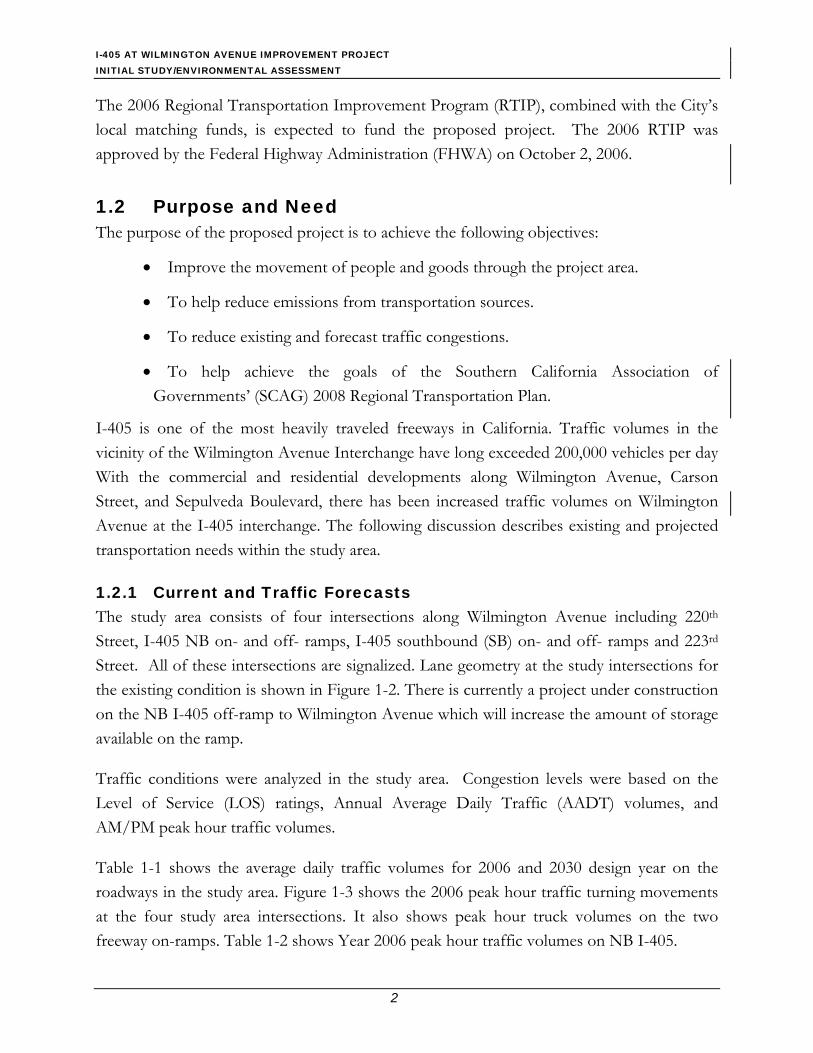
The 2006 Regional Transportation Improvement Program (RTIP), combined with the City’s local matching funds, is expected to fund the proposed project. The 2006 RTIP was approved by the Federal Highway Administration (FHWA) on October 2, 2006.
1.2 Purpose and Need The purpose of the proposed project is to achieve the following objectives:
• Improve the movement of people and goods through the project area.
• To help reduce emissions from transportation sources.
• To reduce existing and forecast traffic congestions.
• To help achieve the goals of the Southern California Association of Governments’ (SCAG) 2008 Regional Transportation Plan.
I-405 is one of the most heavily traveled freeways in California. Traffic volumes in the vicinity of the Wilmington Avenue Interchange have long exceeded 200,000 vehicles per day With the commercial and residential developments along Wilmington Avenue, Carson Street, and Sepulveda Boulevard, there has been increased traffic volumes on Wilmington Avenue at the I-405 interchange. The following discussion describes existing and projected transportation needs within the study area.
1.2.1 Current and Traffic Forecasts The study area consists of four intersections along Wilmington Avenue including 220th Street, I-405 NB on- and off- ramps, I-405 southbound (SB) on- and off- ramps and 223rd Street. All of these intersections are signalized. Lane geometry at the study intersections for the existing condition is shown in Figure 1-2. There is currently a project under construction on the NB I-405 off-ramp to Wilmington Avenue which will increase the amount of storage available on the ramp.
Traffic conditions were analyzed in the study area. Congestion levels were based on the Level of Service (LOS) ratings, Annual Average Daily Traffic (AADT) volumes, and AM/PM peak hour traffic volumes.
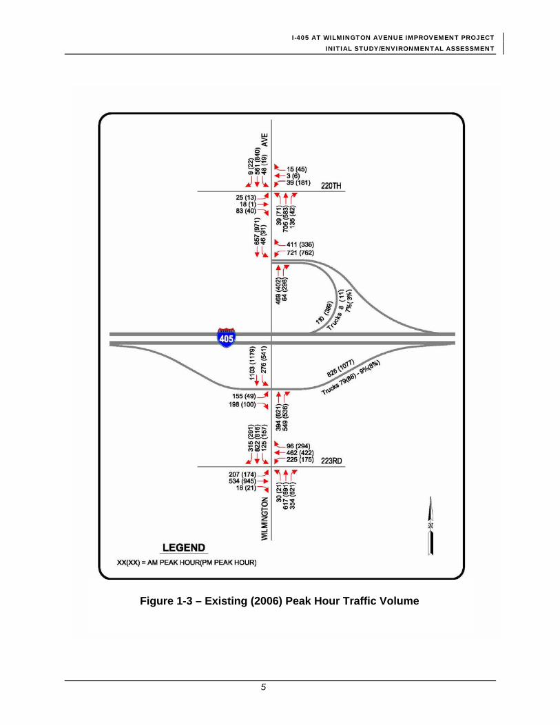
Table 1-1 shows the average daily traffic volumes for 2006 and 2030 design year on the roadways in the study area. Figure 1-3 shows the 2006 peak hour traffic turning movements at the four study area intersections. It also shows peak hour truck volumes on the two freeway on-ramps. Table 1-2 shows Year 2006 peak hour traffic volumes on NB I-405.

I-405 AT WILMINGTON AVENUE IMPROVEMENT PROJECT INITIAL STUDY/ENVIRONMENTAL ASSESSMENT
3
Figure 1-2 – Existing Intersection Configuration

I-405 AT WILMINGTON AVENUE IMPROVEMENT PROJECT INITIAL STUDY/ENVIRONMENTAL ASSESSMENT
4
Table 1-1 Average Daily Traffic Volumes for 2006 and 2030
Intersection with Wilmington Avenue 2006 Volume 2030 Volume
Wilmington Avenue North of I-4051 20,600 25,500 Wilmington Avenue South of I-4051 30,000 37,200 I-405 NB Loop On-Ramp2 4,100 5,100 I-405 SB On-Ramp2 16,900 20,900 I-405 NB Off-Ramp2 17,700 21,900 I-405 SB Off-Ramp2 5,800 7,100 I-405 North of Wilmington Avenue3 263,000 325,000 I-405 South of Wilmington Avenue3 288,000 356,000 1 2001 Counts plus 5% growth, average daily volumes 2 Volumes used on Caltrans Traffic Accident Surveillance and Analysis System (TASAS) Table B 7/1/03-6/30/06 for each ramp 3 2005 AADT Caltrans Report, average annual daily volumes
Source: Parsons, 2007a.
Table 1-2 Year 2006 NB I-405 Peak Hour Traffic Volumes
I-405 North of Wilmington Avenue Interchange AM Peak PM Peak
Peak hour volume combined directions in all lanes 17,8001 17,1002 NB volume 9,4573 7,9143 NB Highly Occupied Vehicles (HOV) volume 1,5134 1,2664 NB general purpose lanes volume 7,944 6,648 1Caltrans 2005 AADT table plus one percent growth 2Calculation from AM volume based on K factors in Caltrans 2006 Peak Hour Volume Data Report 3Calculated from previous row and D factors in Caltrans 2006 Peak Hour Volume Data Report 4Calculated from previous row and comparative HOV and mixed flow lane data in Caltrans District 7 2006 HOV Annual Report
Source: Parsons, 2007a. Traffic forecasts for the study area were developed for the 2030 design year. Based on recent traffic growth, an annual traffic growth rate of one percent was assumed for the project area from year 2006 to year 2030. Daily and peak hour traffic volumes for the 2030 design year were determined by increasing the year 2006 volumes by 24 percent as shown in Table 1-1.
I-405 AT WILMINGTON AVENUE IMPROVEMENT PROJECT INITIAL STUDY/ENVIRONMENTAL ASSESSMENT
5
Figure 1-3 – Existing (2006) Peak Hour Traffic Volume

I-405 AT WILMINGTON AVENUE IMPROVEMENT PROJECT INITIAL STUDY/ENVIRONMENTAL ASSESSMENT
6
1.2.2 Level-of-Service (LOS) and Queuing Congestion levels were analyzed using the LOS procedures presented in the Highway Capacity Manual – 2000 Edition (HCM). LOS is a measure of the quality of traffic flow and can denote any of an infinite number of combinations of traffic operating conditions that may occur on a given travel lane or at a given intersection when it is subjected to various traffic volumes.
Table 1-3 shows LOS definitions for signalized intersections. There are six levels of service, A through F, which relate to traffic congestion from best to worst, respectively. In general, Level A represents free-flow conditions with no congestion whereas Level F represents severe congestion with stop-and-go conditions. Levels E and F typically are considered to be unsatisfactory. Corresponding to each intersection LOS shown in Table 1-4 is an average vehicular delay that is estimated by the HCM method for signalized intersections. This value indicates the amount of delay, expressed in seconds, that the average motorist at the intersection is expected to experience at a signalized intersection.
Table 1-3 Signalized Intersection Level of Service (LOS) and Delay
LOS Interpretation
Average Delay
(seconds)
A Uncongested operations; all vehicles clear in a single cycle. 0.0-10.0 B Uncongested operations; all vehicles clear in a single cycle. 10.1-20.0 C Light congestion; occasional backups on critical approaches. 20.1-35.0 D Congestion on critical approaches, but intersection functional. Vehicles required to
wait through more than one cycle during short peaks. No long-standing lines formed. 35.1-55.0
E Severe congestion with some long-standing lines on critical approaches. Blockage of intersection may occur if traffic signal does not provide for protected turning movements.
55.1-80.0
F Total breakdown with stop-and-go operations. >80.0
Source: Transportation Research Board, Highway Capacity Manual, 2000.
Table 1-4 shows the peak hour intersection LOS for the study area in the years 2006, 2011 (opening year), and 2030 (design year). All four intersections are forecast to operate at LOS F under the No Build alternative during both peak hours in year 2030, with the exception of Wilmington Avenue/220th Street intersection, which is expected to continue to operate at LOS C in the AM peak hour.
I-405 AT WILMINGTON AVENUE IMPROVEMENT PROJECT INITIAL STUDY/ENVIRONMENTAL ASSESSMENT
7
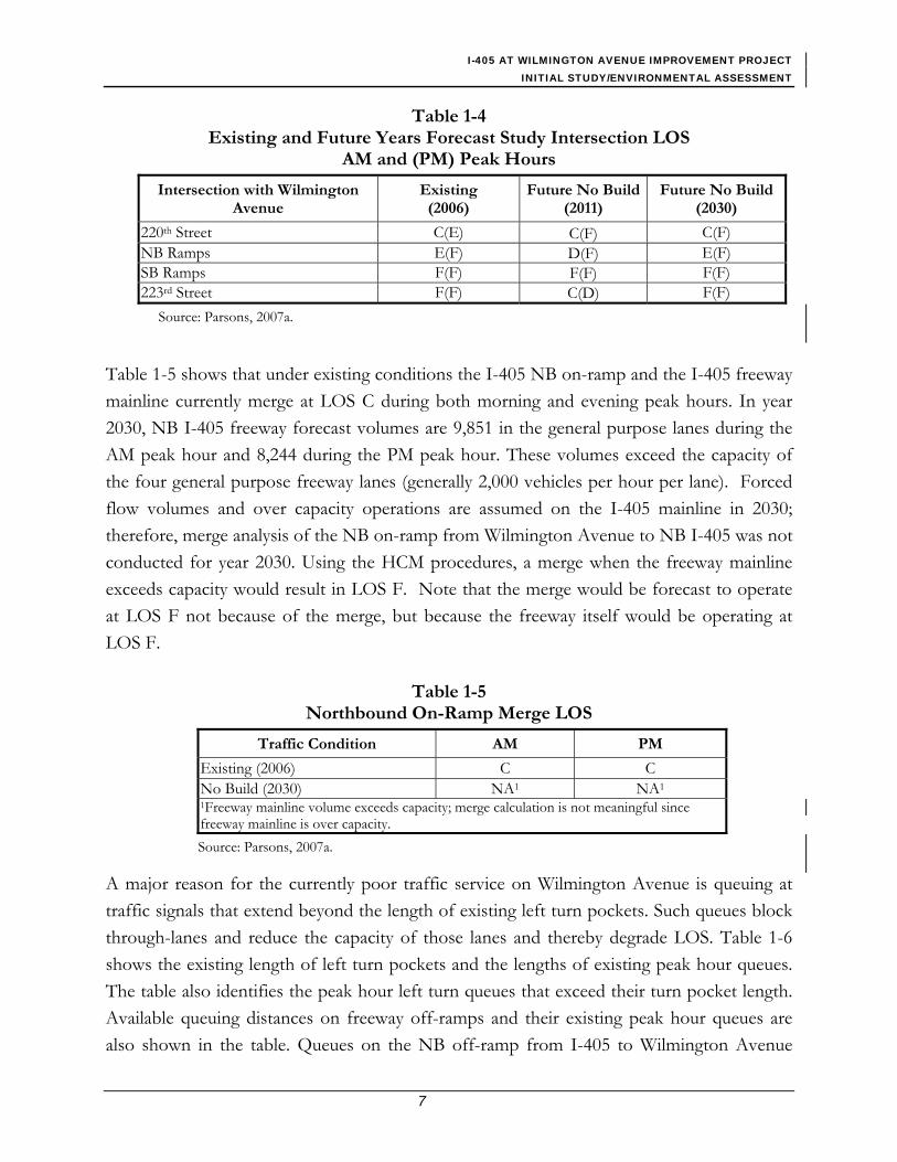
Table 1-4 Existing and Future Years Forecast Study Intersection LOS
AM and (PM) Peak Hours
Intersection with Wilmington Avenue
Existing (2006)
Future No Build (2011)
Future No Build(2030)
220th Street C(E) C(F) C(F) NB Ramps E(F) D(F) E(F) SB Ramps F(F) F(F) F(F) 223rd Street F(F) C(D) F(F)
Source: Parsons, 2007a.
Table 1-5 shows that under existing conditions the I-405 NB on-ramp and the I-405 freeway mainline currently merge at LOS C during both morning and evening peak hours. In year 2030, NB I-405 freeway forecast volumes are 9,851 in the general purpose lanes during the AM peak hour and 8,244 during the PM peak hour. These volumes exceed the capacity of the four general purpose freeway lanes (generally 2,000 vehicles per hour per lane). Forced flow volumes and over capacity operations are assumed on the I-405 mainline in 2030; therefore, merge analysis of the NB on-ramp from Wilmington Avenue to NB I-405 was not conducted for year 2030. Using the HCM procedures, a merge when the freeway mainline exceeds capacity would result in LOS F. Note that the merge would be forecast to operate at LOS F not because of the merge, but because the freeway itself would be operating at LOS F.
Table 1-5 Northbound On-Ramp Merge LOS
Traffic Condition AM PM
Existing (2006) C C No Build (2030) NA1 NA1 1Freeway mainline volume exceeds capacity; merge calculation is not meaningful since freeway mainline is over capacity. Source: Parsons, 2007a.
A major reason for the currently poor traffic service on Wilmington Avenue is queuing at traffic signals that extend beyond the length of existing left turn pockets. Such queues block through-lanes and reduce the capacity of those lanes and thereby degrade LOS. Table 1-6 shows the existing length of left turn pockets and the lengths of existing peak hour queues. The table also identifies the peak hour left turn queues that exceed their turn pocket length. Available queuing distances on freeway off-ramps and their existing peak hour queues are also shown in the table. Queues on the NB off-ramp from I-405 to Wilmington Avenue

I-405 AT WILMINGTON AVENUE IMPROVEMENT PROJECT INITIAL STUDY/ENVIRONMENTAL ASSESSMENT
8
currently extend onto the mainline of the freeway in both morning and evening peak hours. There is a project currently under construction that will increase the storage on the ramp. That project is included in the No Build condition.
Table 1-6 also shows that the queuing problems would have deteriorated by year 2030 under the No Build condition, except on the NB exit ramp where the ongoing construction project results in an improved queuing situation. However, the SB off-ramp is forecast to have a queue that extends onto the freeway mainline in the morning peak hour under the No Build condition in year 2030.
Table 1-6 Comparison of Turn Pocket Length and Freeway Off-Ramp Storage for
Existing (2006) and Future No Build (2030) Condition Peak Hour1
Existing Condition (2006) Future No Build Condition (2030)
Intersection with Wilmington Avenue
Storage Length (feet)
AM Peak Length (feet)
PM PeakLength (feet)
Storage Length (feet)
AM Peak Length (feet)
PM Peak Length (feet)
SB Left at 220th Street 217 81 49 217 117 57 NB Left at 220th Street 56 48 92 56 33 113 SB Left at NB Ramps 149 126 112 149 93 97 NB Off-Ramp 9501 1,178 1,564 12581, 2 6412 1,1082 SB Left at SB Ramps 280 379 868 280 457 1,140 SB Off-Ramp 6081 530 244 6081 780 346 SB Left at 223rd Street 203 273 415 203 345 502 NB Left at 223rd Street 221 96 86 221 126 104 Eastbound Left at 223rd Street 299 386 453 299 563 562 Westbound Left at 223rd Street 188 416 453 188 602 562 Bold Type face indicated a queue exceeding storage 1 95th Percentile queue length 2 Crosswalk to exit nose 3 Reflects completion of current project to increase storage on this ramp.
Source: Parsons, 2007a.
1.2.3 Accident Rates A Caltrans Traffic Accident Surveillance and Analysis System (TASAS) summary of accident records for the three year period, July 1, 2003 to June 30, 2006, was reviewed (see Table 1-7). For I-405 mainline traffic at the Wilmington Avenue interchange, the total actual accident rate is lower than the statewide average.

I-405 AT WILMINGTON AVENUE IMPROVEMENT PROJECT INITIAL STUDY/ENVIRONMENTAL ASSESSMENT
9
Table 1-7 Ramp Accident Rates at the I-405/Wilmington Interchange
(July 1, 2003 to June 30, 2006)
Accident Rate (A/MVM) No. of Accidents Person Actual Rate Average Rate
Ramp FAT F+I TOT Killed Injured FAT F+I TOT FAT F+I TOT
SB Off-ramp (PM 9.71) 0 2 13 0 2 0.000 0.32 2.08 0.005 0.61 1.50
SB On-ramp (PM 9.39) 0 0 10 0 0 0.000 0.00 0.55 0.002 0.32 0.80
NB On-ramp (PM 9.39) 0 3 14 0 5 0.000 0.67 3.12 0.003 0.32 0.85
NB Off-ramp (PM 9.38) 0 8 26 0 10 0.000 0.42 1.36 0.005 0.61 1.50
FAT = Fatal; F+I = Fatal and Injuries; TOT = Total A/MVM = Accidents per Million Vehicle Miles Source: TASAS Table B, District 7.
The SB off-ramp has a total accident rate higher than the statewide average. However, 11 of the 13 accidents (85 percent) reported occurred at the ramp terminus or intersection. The TASAS Selective Accident Retrieval (TSAR) Accident Summary indicates that 31 percent of the accidents were sideswipe accidents, 39 percent were rear end accidents, and 23 percent were broadside accidents. Improvements to the ramp terminus and intersection are included in the proposed project. With these improvements it would be expected that the total accidents would be reduced by approximately 50 percent, which is equivalent to the reduction of approximately 6 accidents. This would bring the accident rate to below the statewide average.
The SB on-ramp has accident rates lower than the statewide average. Most of the accidents (7 of 10 or 70 percent) occurred at the ramp entry and intersection area. With the proposed improvements it would be expected that the total accidents would be reduced by approximately 50 percent, which is equivalent to the reduction of approximately 5 accidents.
For the NB on-ramp, 78.6 percent of accidents occurred on Wilmington Avenue in the vicinity of the ramp entrance. The rate of fatal and injury accidents is more than twice as high as the statewide average and the rate of total accidents is more than 3.5 times the statewide average. With the proposed improvements it would be expected that the total accidents would be reduced by approximately 50 percent, which is equivalent to the reduction of approximately 7 accidents. This would bring the accident rate to below the statewide average.
I-405 AT WILMINGTON AVENUE IMPROVEMENT PROJECT INITIAL STUDY/ENVIRONMENTAL ASSESSMENT
10
The NB off-ramp has an accident rate lower than the statewide average. This ramp has recently been improved with the addition of a second lane along the portion of the ramp downstream of it single lane entry from the freeway and a third lane on the ramp approach to the arterial. Although not a part of this project, these improvements alone would be expected to reduce the number of total accidents at this ramp intersection by at least 50 percent or approximately 13 accidents. The proposed improvement for this project would also be expected to minimally reduce the number of accident perhaps by 15 percent or a reduction of 2 accidents.
1.2.4 Commuter Time Savings Time savings for commuters at the intersections along Wilmington Avenue in the future year (2030) with the proposed project improvement is estimated and presented in Table 1-8 in terms of the delay time.
Table 1-8 Intersection Delay Along Wilmington Avenue in the Study Area
Existing (Year 2006) Future Year (2030) Time Saving
AM Peak PM Peak AM Peak PM Peak AM Peak PM Peak 143 119.6 NA NA NA NA 262 292.7 41.1 77.8 220.9 214.9
Source: Parsons, 2007a.
1.3 Project Description This section describes the proposed action and the design alternatives that were developed by a multi-disciplinary team to achieve the project purpose and need while avoiding or minimizing environmental impacts. The alternatives are Alternative “1,” Alternative “2,” and the No-Build Alternative.
1.3.1 Existing Facility The proposed project is located at the I-405/Wilmington Avenue interchange, which is a fully developed urban/industrial area in the city of Carson approximately 16 miles south of downtown Los Angeles. The city’s municipal boundaries encompass approximately 19.3 square miles of land in the South Bay region of Los Angeles County. It is served by the Harbor Freeway (I-110), which runs between the Los Angeles Harbor and downtown Los Angeles; the San Diego Freeway (I-405), which runs from Orange County north through the San Fernando Valley; and the Artesia Freeway or State Route (SR) 91, which runs from Redondo Beach east to Riverside County.

I-405 AT WILMINGTON AVENUE IMPROVEMENT PROJECT INITIAL STUDY/ENVIRONMENTAL ASSESSMENT
11
Wilmington Avenue is an arterial roadway that runs north/south through the cities of Carson, Compton, and Los Angeles. It provides access to I-405 and SR 91 in Carson, as well as to the adjacent communities of Compton to the north and Wilmington to the south. A development of single-family homes is located along SB Wilmington Avenue, north of I-405, in the study area; however, access to this residential complex is provided from 220th Street. The rest of the properties along Wilmington Avenue are either commercial or industrial.
The study area is intersected by the Dominguez Channel, which runs in a northwest-southeast direction. The Dominguez Channel is a natural bottom channel that discharges to the Los Angeles Harbor and the Pacific Ocean.
The east-west running 223rd Street is an arterial highway that extends through Carson from Western Avenue (SR 213) in the west to the Long Beach Freeway or I-710 to the east, some 6 miles away; 223rd Street becomes Wardlow Road and continues into Long Beach. The land use along 223rd Street is heavy industrial and commercial; however, farther to the west, residential uses can also be found. Numerous trucking companies are located along 223rd Street near the project. On-street parking is generally prohibited, and the posted speed limit on 223rd Street is 45 miles per hour.
Union Pacific Railroad (UPRR) has an at-grade crossing with 223rd Street approximately 780 feet west of the Wilmington Avenue intersection. This railroad is not a major through-line, and it provides loading/unloading service to a few trucking companies located south of 223rd Street.
1.3.2 Project Alternatives This section describes the Alternatives that comprise the proposed project:
• No-Build Alternative,
• Alternative 1 - the Street Widening and Ramp Modifications,
• Alternative 2 - the Street Widening, Ramp Modifications, and New NB On-ramp
“No Build” Alternative This alternative would maintain the current configuration of the interchange and the surrounding local streets. Congestion within the project limits would not be alleviated and the situation would deteriorate over time. This approach is inconsistent with Caltrans’ goal

I-405 AT WILMINGTON AVENUE IMPROVEMENT PROJECT INITIAL STUDY/ENVIRONMENTAL ASSESSMENT
12
of providing an efficient interregional mobility system. There would be no cost associated with this alternative.
Alternative 1: Street Widening and Ramp Modifications Engineering Features This alternative proposes conventional widening of Wilmington Avenue, 223rd Street, and the I-405 ramps to enhance their capacity, reduce conflicting movements, and alleviate traffic congestion (see Figure 1-4). The project components under Alternative 1 include:
• Reconstructing the I-405 SB off-ramp terminus and providing two turn lanes at the ramp intersection with Wilmington Avenue. A short retaining wall would be constructed along the south side of the ramp.
• Widening the I-405 SB on-ramp to accommodate truck turning and to provide standard shoulders, standard freeway entrance geometrics and a 30-to-1 taper for the lane drop beyond the ramp meter limit line. A short retaining wall would be constructed along the north side of the ramp.
• Relocating the sidewalk on the east side of Wilmington Avenue to behind the bent; widening Wilmington Avenue, including the bridge over the Dominguez Channel, to provide an additional through lane on the approach to the 223rd Street intersection and an additional shared through and right-turn lane on the approach to the SB on-ramp intersection in the NB direction; providing dual southbound left-turn lanes in the place of single left-turn lane at the I-405 SB on-ramp intersection and the 223rd Street intersection; changing the existing SB dedicated right-turn lane at the 223rd Street intersection to a shared through and right-turn lane.
• Widening the departure on the eastbound (EB) 223rd Street from the Wilmington Avenue intersection to accommodate the southbound Wilmington Avenue dual left-turn movements; providing dual left-turn lane in the place of single left-lane on 223rd Street at the intersection in both direction; eliminating the EB dedicated right-turn lane; change the No. 2 EB through lane to a shared through and right-turn lane.
• Providing curb ramps on the curb returns at the Wilmington Avenue and 223rd Street intersection to comply with requirements of the Americans with Disabilities Act of 1990 (ADA); and eliminating the crosswalk at the west leg of the intersection.
D o m i n g u e z
C h a n n e l
WILMING
TON
E. 223RD ST.
PARSONS
S A ND I E G O
F W Y.
405
E. 22OTH ST.
Figure 1-4Aerial View of Proposed Improvements
AVE.
NNO SCALE
S P R R
Widen existing bridge (Alt 1 & 2)
Construct a retaining wall and widen the ramp on the south side, reconstruct the existing ramp to provide a 2-lane PCC
ramp terminus (Alt 1 & 2)
Widen E/B 223rd St. at Wilmington Intersection, provide dual left-turn lanes on SB, EB, and WB directions, and eliminate
crosswalk at the west leg of the intersection(Alt 1 & 2)
Widen ramp and construct short retaining wall on the north side
(Alt 1 & 2)
Construct new N/B On-Ramp, soundwalls on retaining walls along the right edge of the shoulder of the
ramp and the NB I-405. (Alt 2 only)
Eliminate left turn to existing N/B On-Ramp
(Alt 2 only)
Increase curve return radius(Alt 1 & 2)
I-405 / WILMINGTON AVENUE INTERCHANGE IMPROVEMENT PROJECT
I-405 N/B Off Ramp
I-405 NORTHBOUNDI-405 SOUTHBOUND
OnN/B
I-405
Ramp
I-405 S/B On Ramp
I-405 S/B
Widen Wilmington Ave. to provide 3 through-lanes on both directions and dual
SB left-turn lanes to I-405 SB on-ramp (Alt 1 & 2)
Widen existing bridge (Alt 2 only)
Note, this figure provide graphical representation of the proposed improvements, it does not represent the true engineering scale.
3/30/07
Off Ramp
Potential Staging Area

I-405 AT WILMINGTON AVENUE IMPROVEMENT PROJECT INITIAL STUDY/ENVIRONMENTAL ASSESSMENT
14
This page intentionally left blank.

I-405 AT WILMINGTON AVENUE IMPROVEMENT PROJECT INITIAL STUDY/ENVIRONMENTAL ASSESSMENT
15
• Synchronizing new and modified traffic signals within the project limits and connecting them to CTNET (an advanced traffic management system that Caltrans uses for managing their surveillance and communication network and traffic signals and provides link between traffic signal systems operated by local agencies and by Caltrans).
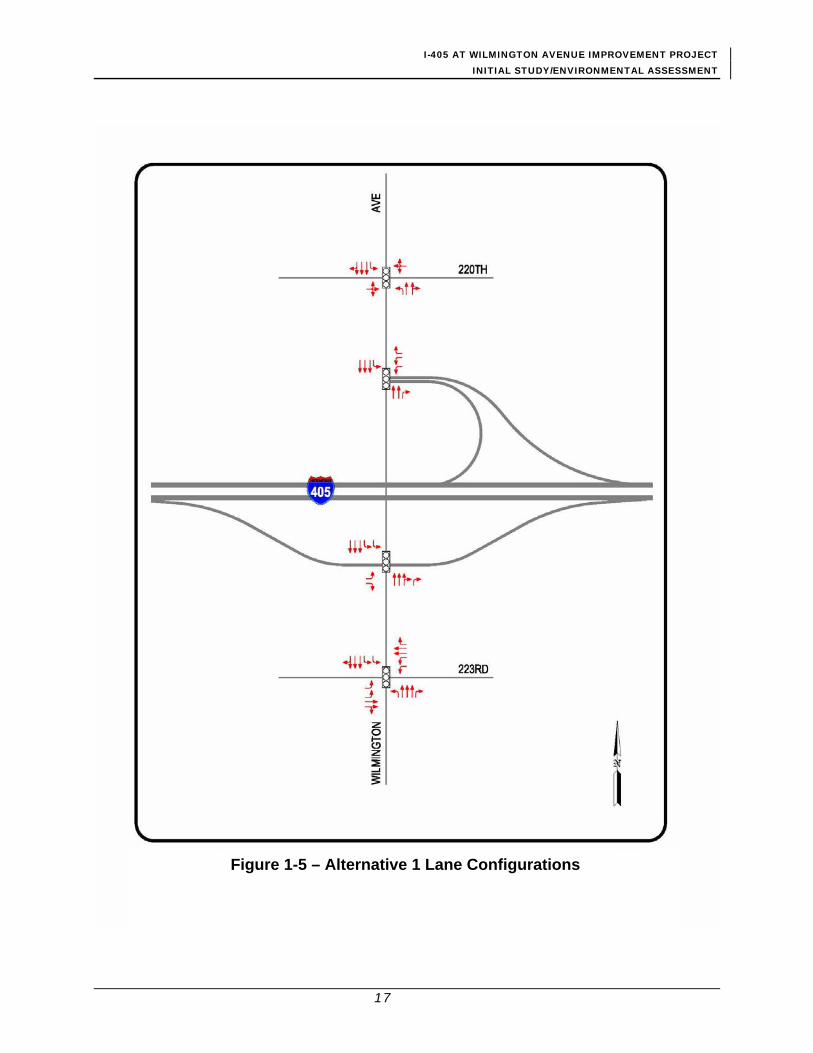
Lane configurations with the proposed Alternative 1 improvements are presented in Figure 1-5.
Cost Estimates A preliminary cost estimate is for Alternative 1 is presented in Table 1-9.
Table 1-9 Alternative 1 Cost Estimate*
Within State Right-
of-Way Outside State Right-of-Way
Total
Roadway $5,979,000 $4,805,000 $10,784,000
Demolition $545,000 $290,000 $835,000
Structure $0 $2,000,000 $2,000,000
Right of Way $770,500 $1,189,400 $1,959,900
Engineering, Construction Management, and Project Administration
$979,000 $1,065,000 $2,044,000
Total $8,273,500 $9,349,400 $17,622,900
* Numbers rounded
Alternative 2: Street Widening, Ramp Modifications, and New NB On-ramp
Alternative 2 would provide all improvement described under Alternative 1, and in addition a new on-ramp would be provided to serve the traffic moving from southbound Wilmington Avenue to NB I-405 (refer to Figure 1-4). The ramp would not carry a large volume of traffic, but it would eliminate the SB Wilmington Avenue left turns at the existing northbound ramp intersection, thus improving the LOS for the remaining movements. The additional project components under Alternative 2 include:
• Providing a new compact diamond type northbound on-ramp in the northwest quadrant of the interchange. The NB I-405 bridge over Dominguez Channel (Bridge No. 53-1166) would be widened to accommodate the new ramp.
I-405 AT WILMINGTON AVENUE IMPROVEMENT PROJECT INITIAL STUDY/ENVIRONMENTAL ASSESSMENT
16
• Constructing soundwalls on retaining walls along the right edges of shoulder of the NB I-405 and the new NB on-ramp.
• Reconstructing the shoulder along the existing I-405 main line auxiliary lane west of the Wilmington Avenue undercrossing to accommodate a standard shoulder width and a standard auxiliary lane drop.
• Eliminating the conflicting left-turn movements from SB Wilmington Avenue to the NB loop on-ramp.
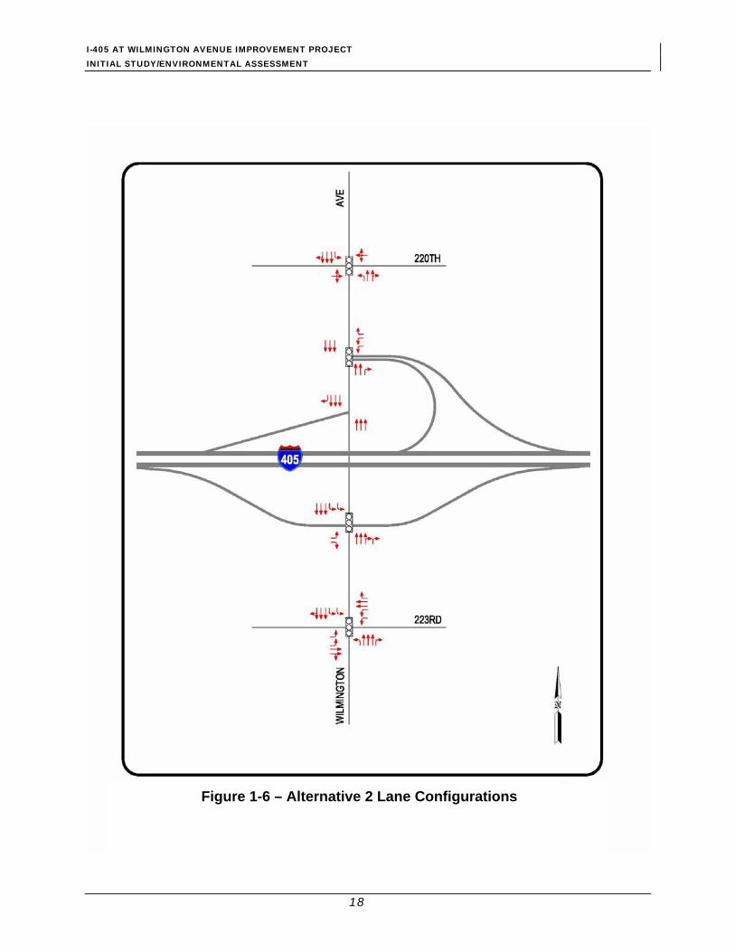
Lane configurations with the proposed Alternative 2 improvements are presented in Figure 1-6.
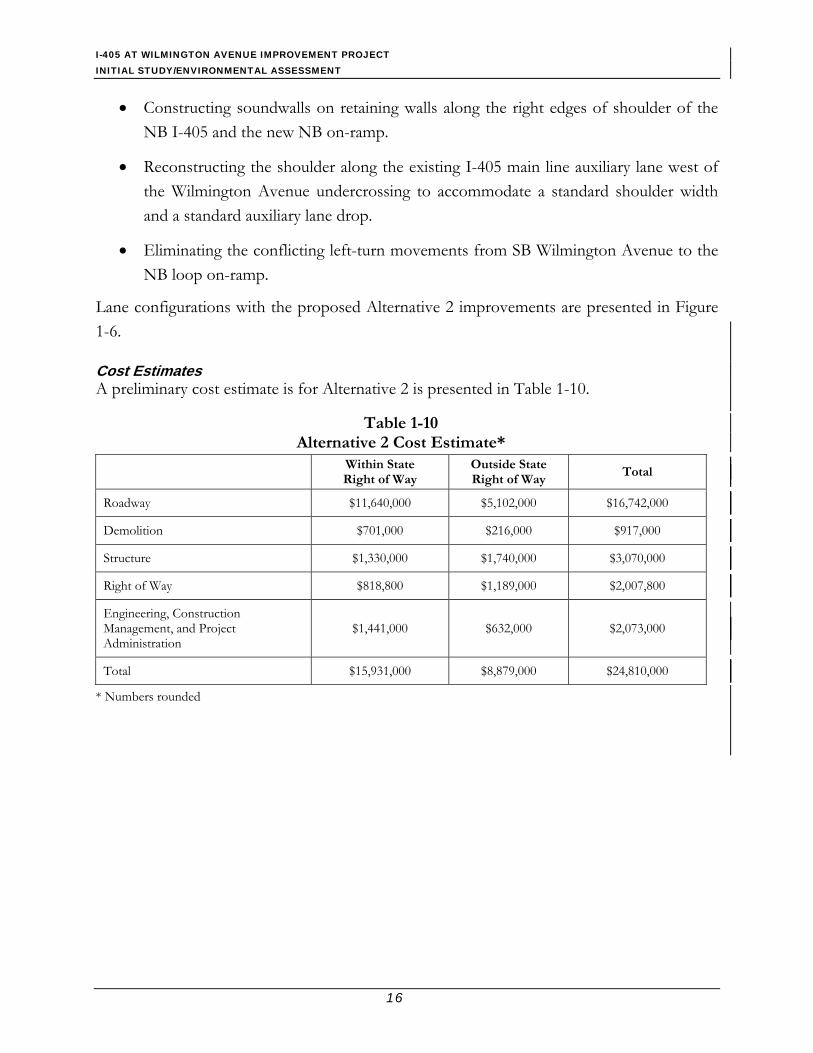
Cost Estimates A preliminary cost estimate is for Alternative 2 is presented in Table 1-10.
Table 1-10 Alternative 2 Cost Estimate*
Within State Right of Way
Outside State Right of Way
Total
Roadway $11,640,000 $5,102,000 $16,742,000
Demolition $701,000 $216,000 $917,000
Structure $1,330,000 $1,740,000 $3,070,000
Right of Way $818,800 $1,189,000 $2,007,800
Engineering, Construction Management, and Project Administration
$1,441,000 $632,000 $2,073,000
Total $15,931,000 $8,879,000 $24,810,000
* Numbers rounded
I-405 AT WILMINGTON AVENUE IMPROVEMENT PROJECT INITIAL STUDY/ENVIRONMENTAL ASSESSMENT
17
Figure 1-5 – Alternative 1 Lane Configurations
I-405 AT WILMINGTON AVENUE IMPROVEMENT PROJECT INITIAL STUDY/ENVIRONMENTAL ASSESSMENT
18
Figure 1-6 – Alternative 2 Lane Configurations

I-405 AT WILMINGTON AVENUE IMPROVEMENT PROJECT INITIAL STUDY/ENVIRONMENTAL ASSESSMENT
19
1.3.3 Identification of the Preferred Alternative Following circulation of the draft environmental document and careful evaluation of all comments by the public and local agencies, the project development team selected Alternative 2 as the preferred alternative. Alternative 2 is the preferred alternative because it meets the purpose and need of the project by reducing current and proposed traffic congestion and by enhancing safety. Specifically Alternative 2 is a better improvement compared to Alternative 1 because it eliminates conflicting left-turn movements from southbound Wilmington Avenue to the northbound loop on-ramp. In addition, implementation of Alternative 2 would not result in environmental impacts that could not be mitigated. Implementation of Alternative 1 would meet the project purpose and need, but would not eliminate the conflicting left-turn movements from SB Wilmington Avenue to NB loop on-ramp.
1.4 Alternatives Considered but Eliminated from Further Discussion
Eleven conceptual alternatives for the interchange improvements were studied during the Project Study Report phase and presented to the Project Development Team on December 5, 2001. The alternatives included:
• Widening and restriping • Northbound I-405 tight diamond on-ramp • Cloverleaf interchange • Hook ramps at 223rd Street east of Wilmington Avenue • Hook ramps at 223rd Street west of Wilmington Avenue • Partial cloverleaf • Full cloverleaf • Southbound on-ramp flyover • Northbound off-ramp flyover • Northbound and southbound off-ramp flyover • Northbound and southbound off-ramp flyover and quadrant cloverleaf
Following detailed discussions and consideration of the constraints, the viable alternatives were carried forward and it was unanimously agreed to not further pursue the rejected alternatives.
I-405 AT WILMINGTON AVENUE IMPROVEMENT PROJECT INITIAL STUDY/ENVIRONMENTAL ASSESSMENT
20
1.5 Scheduling A 2-year construction period is scheduled to commence in mid-2010 and be complete by mid 2012. Construction will be divided into three stages as outlined below:
Stage 1: This phase of construction would last about 13 months and would include the following activities:
• Phase 1: This phase would take approximately 3 months and would include the following activities
− Constructing the soundwall on retaining walls along the NB I-405 freeway and new NB on-ramp (for Alternative 2 only)
− Constructing the new I-405 NB on-ramp
• Phase 2: This phase would take approximately 3 months and would include the following activities
− Widening the NB Wilmington Avenue and the east side of the Dominguez Channel Bridge at the intersection with 223rd Street
• Phase 3: This phase would take approximately 7 months and would include the following activities
− Widening the NB I-405 freeway bridge over Dominguez Channel
− Constructing southerly retaining wall along the I-405 SB off-ramp and
− Widening the south sides of the I-405 SB on- and off-ramps Stage 2: This stage of construction would last about 8 months and would include the following activities:
• Continuing the new NB on-ramp construction (Alternative 2) and the freeway ramp widening
• Widening the SB Wilmington Avenue and the west side of the Dominguez Channel bridge at the 223rd Street intersection
• Constructing the northerly retaining walls along the I-405 SB on- and off-ramps
• Widening the north sides of the I-405 SB on- and off-ramps Stage 3: This phase of construction would last about 3 months and would include the following activities:
• Constructing raised medians on Wilmington Avenue and 223rd Street

I-405 AT WILMINGTON AVENUE IMPROVEMENT PROJECT INITIAL STUDY/ENVIRONMENTAL ASSESSMENT
21
• Overlaying Wilmington Avenue
1.6 Other Projects Several projects were identified that are approved or planned within the project vicinity, including:
1. I-405 NB off-ramp at Wilmington Avenue modification (Caltrans Contract No. EA07-188804 Route: 07-LA-405-14.6/15.1). Construction started in January 2007, and will be completed by July 2007.
2. I-405 and Avalon Boulevard interchange modification (Caltrans Project Nos. EA07186-23390K, 07-186-23400K, and 07-932083). This project is under environmental review. Construction is expected to commence in summer 2008 and be completed by summer 2010.
3. Construction of a soundwall along I-405 between Long Beach Boulevard and Stagg Street in the City of Long Beach and City of Carson (Caltrans Project No. EA-07-186-23300K, 07-LA-405-KP 6.4/43/1). The purpose of the project is to reduce traffic noise levels and exposure at noise-sensitive residential uses adjacent to the freeway from Long Beach Boulevard to 223rd Street along I-405. The project will be funded by the Los Angeles County Metropolitan Transportation Authority (MTA). The Noise Barrier Scope Summary Report (NBSSR) was prepared and approved in March 2004. Construction is scheduled to commence in March 2008 and be completed in April 2009.
4. Slab replacement and grinding in Long Beach, Carson, and Signal Hill from Los Angeles and Orange County line to I-405 and I-110 separation (Caltrans Project No. EA 244404). PS&E was prepared in June 2005. The construction schedule was not finalized by the time of preparation of this report.
5. Installing and upgrading flared end sections of existing metal beam guardrails at various locations on I-405 from PM 0.0 to 48.5 and I-110 from PM 0.0 to 33.15 (Caltrans Project No. EA 243601). The construction schedule was not finalized by the time of preparation of this report.

I-405 AT WILMINGTON AVENUE IMPROVEMENT PROJECT INITIAL STUDY/ENVIRONMENTAL ASSESSMENT
22
1.7 Permits and Approvals Needed Prior to commencement of the construction activities, the following permits or approvals will be required:
Agency Permit/Approval
U.S. Army Corps of Engineers (USACOE) Section 404 Permit for dredging and filling in the Dominguez Channel
Los Angeles Regional Water Quality Control Board (RWQCB)
Section 401 Water Quality Certification for work in the Dominguez Channel
RWQCB Groundwater Dewatering Permit for discharges of groundwater from construction and project dewatering to surface waters in coastal watersheds of Los Angeles
California Department of Fish and Game (CDFG)
Section 1602 Agreement for Streambed Alteration
Los Angeles County Department of Public Works
Encroachment Permit for modifications that will impact the right of way or the hydraulic system of the Dominguez Channel
Public Utilities Commission Railroad crossing improvement permit Union Pacific Railroad (UPRR) Railroad License/Agreement for work within
railroad ROW City of Carson Grading and construction permits
23
2.0 AFFECTED ENVIRONMENT, ENVIRONMENTAL CONSEQUENCES, AND MITIGATION MEASURES
2.1 Introduction The proposed project is a joint project by Caltrans in corporation with the City of Carson and the FHWA and is subject to state and federal environmental review requirements. Project documentation has been prepared in compliance with both the California Environmental Quality Act (CEQA) and the National Environmental Policy Act (NEPA). FHWA’s responsibility for environmental review, consultation, and any other action required in accordance with NEPA and other applicable Federal laws for this project is being carried out by Caltrans under its assumption of responsibility pursuant to 23 United States Code (U.S.C.) 327. Caltrans is the lead agency under CEQA and NEPA.
Each environmental factor analysis includes discussion of the affected environment, environmental consequences and avoidance, minimization, and compensation measures of each project alternatives. When the impacts are found to be potentially significant, as determined pursuant to CEQA, mitigation measures are developed to minimize the impacts to a less than significant level. CEQA requires that each significant effect on the environment resulting from the project be identified and mitigated.
CEQA has suggested thresholds of significance to be used as bases for determining mitigation (CEQA Guidelines Section 15064.7). Per NEPA regulations (40 Code of Federal Regulations [CFR] 1508.27), significance is based on context and intensity. The magnitude of the impact is evaluated and no judgment of its significance is made in the document. Usage of the term “significance” in this document is being made pursuant to CEQA only. Under NEPA, all impacts are discussed regardless of threshold amount and include mitigation measures where reasonable. Each section discusses mitigation measures, the CEQA significance criteria, and the context and intensity of environmental impacts as required by NEPA.
Analysis and discussion of various environmental factors are primarily based on a review of natural resource databases and scientific literature, and technical studies including:

I-405 AT WILMINGTON AVENUE IMPROVEMENT PROJECT INITIAL STUDY/ENVIRONMENTAL ASSESSMENT
24
• Traffic Study (Parsons, 2007a)
• Air Quality Analysis (Parsons, 2007b)
• Archaeological Survey Report (ECORP, 2007a)
• Paleontology Study Report (ECORP, 2007b)
• Historic Property/Architecture Survey Report (ECORP, 2007c)
• Community Impact Assessment (Parsons, 2007c)
• Hydrology, Floodplain, Water Quality, and Stormwater Runoff Impact Analysis (Parsons, 2007d)
• Natural Environmental Study (Parsons, 2007e)
• Noise Study Report (Parsons, 2007f)
• Visual Impact Analysis (Parsons, 2007g)
• Initial Site Assessment (MCE, 2003)
2.1.1 Resources Considered but Determined to not Be Relevant The following environmental resources were considered but determined to not be relevant due to their absence from the project area. Consequently, there is no further discussion regarding these resources in this document.
Farmland/Timberland. The project site is located in a highly developed, urban area of the City of Carson with no farmland or agricultural resources within the project area and vicinity.
Wetlands and Other Waters. Based on the Natural Environment Study (Parsons, 2007e), no jurisdictional waters of the United States administered by the U.S. Army Corps of Engineers exist within the project site and its vicinity.
Threatened & Endangered Species. Based on the Natural Environment Study (Parsons, 2007e), no sign of threatened & endangered species was observed within the project area.

I-405 AT WILMINGTON AVENUE IMPROVEMENT PROJECT INITIAL STUDY/ENVIRONMENTAL ASSESSMENT
25
2.1.2 Resources Resulting in No Impacts As part of the scoping and environmental analysis conducted for the project, the following environmental resources were considered but no potential for adverse impacts to these resources was identified. Consequently, there is no further discussion regarding these resources in this document (See Appendix A, CEQA Checklist for more information).
Land Use. Impacts on land use and planning were conducted as part of the Community Impact Assessment (Parsons, 2007c). The proposed project is compatible with all existing land use and environmental plans and policies, and it would not require any modification or change to any existing zoning or land use. The project is located within a highly developed area with a mix of land uses including industrial, commercial, and residential. The project is consistent with adopted local plan.
Growth. Growth within the project area and vicinity is controlled by the City of Carson General Plan. The proposed improvements to the I-405/Wilmington Avenue interchange would accommodate growth and relieve congestion within the project locality. The project is not considered growth inducing and would not directly or indirectly contribute to population growth. The proposed project would not require the acquisition or displacement of residents. Thus, the proposed project would not create a demand for additional housing.
Utilities and Service Systems. The proposed project does not include the construction of any new developments that would generate wastewater, solid waste, or increase the demand for water supplies. No impacts are anticipated.
Energy. The proposed project would use fossil fuels for construction equipment operation during the construction period. This increased fuel consumption would be temporary and would cease at the end of the construction activity.
Natural Communities. Based on the Natural Environment Study (Parsons, 2007e), the closest natural community type exists 8.5 miles southwest from the project study area along bluffs at the Palos Verdes Peninsula. No impacts to natural communities would occur.
I-405 AT WILMINGTON AVENUE IMPROVEMENT PROJECT INITIAL STUDY/ENVIRONMENTAL ASSESSMENT
26
2.2 Community Impacts The information presented in this section is excerpted from the Community Impact Assessment prepared for this project (Parsons, 2007c). Three topical areas are discussed under community impacts including community character and cohesion, relocations, and environmental justice consideration.
2.2.1 Community Character and Cohesion Regulatory Setting The NEPA, established that the federal government use all practicable means to ensure for all Americans safe, healthful, productive, and aesthetically and culturally pleasing surroundings (42 U.S.C. 4331[b][2]). The FHWA in its implementation of NEPA (23 U.S.C. 109[h]) directs that final decisions regarding projects are to be made in the best overall public interest. This requires taking into account adverse environmental impacts, such as, destruction or disruption of human-made resources, community cohesion and the availability of public facilities and services.
Under the CEQA, an economic or social change by itself is not to be considered a significant effect on the environment. However, if a social or economic change is related to a physical change, then social or economic change may be considered in determining whether the physical change is significant. Since this project would result in physical change to the environment, it is appropriate to consider changes to community character and cohesion in assessing the significance of the project’s effects.
Affected Environment Community cohesion is the degree to which residents have a “sense of belonging” to their neighborhood, a level of commitment to the community, or a strong attachment to neighbors, groups, and institutions, usually because of continued association over time. The project study area is located in a highly developed urban/industrial area. Prominent commercial/industrial uses in the project area include British Petroleum (BP) Carson Refinery and a portion of 223rd Street designated by the City of Carson as “Auto Row,” which is occupied by automobile dealerships and auto repair shops. Single-family homes are located at the area north of I-405 west of Wilmington Avenue. Typically, residents living in an urbanized area are less cohesive than those living in the rural area, and residents of single-family homes are more cohesive than those living in multi-family units. Based on the number of residents participating in the Open House organized as part of the Project Report
I-405 AT WILMINGTON AVENUE IMPROVEMENT PROJECT INITIAL STUDY/ENVIRONMENTAL ASSESSMENT
27
preparation on May 3, 2007 and the observation of their relationship, community cohesion within the project area is considered moderate to high.
Environmental Consequences Build Alternatives During construction, commercial properties located along Wilmington Avenue and in the project area may experience temporary access changes or restrictions. Traffic lane closures would occur during the approximate 2-year construction period. The proposed project would not change the character of the existing residential community within the project area and its vicinity. The proposed project will not cause any roadway closure or divide any established community within the project area. No impact to community character and cohesion would occur.
No-Build Alternative The No-Build Alternative proposes no construction or physical changes in the project area. As a result, no direct effects would occur with the No-Build Alternative implementation. However, traffic congestion along this portion of Wilmington Avenue would substantially worsen in the future; thus, affecting local businesses and residents as well as commuters along Wilmington Avenue.
2.2.2 Relocations Regulatory Setting The Department’s Relocation Assistance Program (RAP) is based on the Federal Uniform Relocation Assistance and Real Property Acquisition Policies Act of 1970 (as amended) and Title 49 CFR Part 24. The purpose of RAP is to ensure that persons displaced as a result of a transportation project are treated fairly, consistently, and equitably so that such persons will not suffer disproportionate injuries as a result of projects designed for the benefit of the public as a whole.
All relocation services and benefits are administered without regard to race, color, national origin, or sex in compliance with Title VI of the Civil Rights Act (42 U.S.C. 2000d, et seq.). Please see Appendix F for a copy of the Department’s Title VI Policy Statement.
Affected Environment The project site is situated in an urban/industrial area in the City of Carson in the southern portion of Los Angeles County. Existing land uses within the immediate vicinity of the project site are comprised of a mixed use of residential, commercial, and heavy industry. A

I-405 AT WILMINGTON AVENUE IMPROVEMENT PROJECT INITIAL STUDY/ENVIRONMENTAL ASSESSMENT
28
dense single-family residential development is located north of I-405 and west of Wilmington Avenue. Commercial buildings, gas stations, restaurants, and fast-food vendors are located along both sides of Wilmington Avenue between 220th Street and 223rd Street, except for the area where the residential homes are located. A refinery is located west of Wilmington Avenue south of 223rd Street.
The project area is located in a highly developed area of Carson. Based on the City of Carson Web site, 11 major businesses are located within a 2.5-mile radius of the project site. Although no major new development within the immediate vicinity of the project site is expected, more car dealership development could be established along 223rd Street west of Wilmington Avenue since the City of Carson has designated 223rd Street, west of the Dominguez Channel, as “Auto Row.”
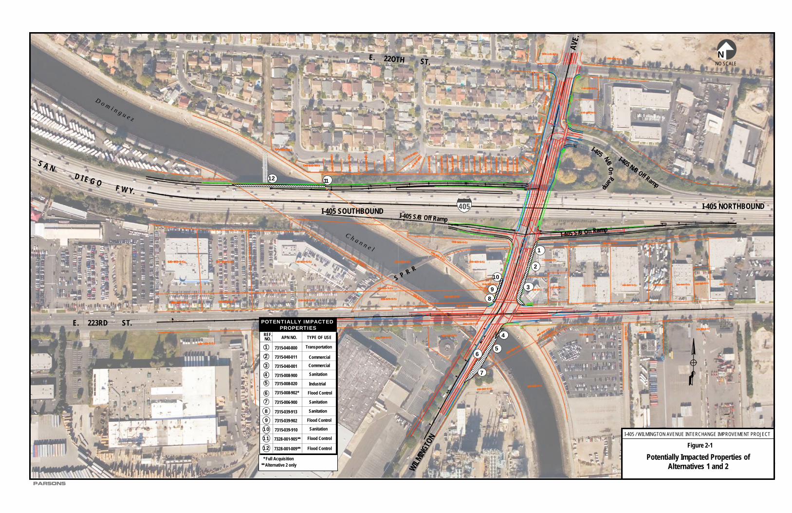
Environmental Consequences Build Alternatives Direct effects on businesses and residences resulting from the proposed project are anticipated to be less than significant, as determined pursuant to CEQA. Right of Way (ROW) required for Alternative 1 would require a full acquisition of one parcel and partial acquisition of nine parcels; two additional partial acquisitions parcels would be required for Alternative 2. The full acquisition parcel (assessor parcel number [APN]7315-008-902) is located at the southeast corner of Wilmington Avenue and 223rd Street and is owned by Los Angeles County Flood Control District. No relocation of the existing industries or businesses would be required. Table 2-1 summarizes, and Figure 2-1 shows the potentially impacted properties from implementation of Alternatives 1 and 2.
Table 2-1 Potentially Impacted Properties
Ref #
Name Type of Use Alternative 1 Alternative 2
1 Railroad ROW Ownership: UPRR APN 7315-040-800
Transportation Partial relinquishment of 467 square feet of railroad ROW at the Wilmington Avenue railroad crossing.
Same as Alternative 1
2 Chevron Gas Station Ownership: MACLAND Investment, Inc. APN 7315-040-011
Commercial Partial relinquishment of approximately 2,011 square feet within State ROW resulting in the loss of landscaping area.
Same as Alternative 1
3 Shell Gas Station Ownership: EQUILON Enterprises, LLC APN 7315-040-001
Commercial Partial taking of approximately 2,654 square feet, resulting in loss of landscaping areas and parking spaces.
Same as Alternative 1
4 Sanitation District Undeveloped Partial loss of land (407 square Same as Alternative 1

I-405 AT WILMINGTON AVENUE IMPROVEMENT PROJECT INITIAL STUDY/ENVIRONMENTAL ASSESSMENT
29
Table 2-1 Potentially Impacted Properties
Ref #
Name Type of Use Alternative 1 Alternative 2
Ownership: County of Los Angeles Sanitation District APN 7315-008-900
feet) required for the bridge widening on northbound Wilmington Avenue and westbound 223rd Street over the Dominguez Channel.
5 Ownership: Watson Land Co APN 7315-008-020
Industrial Partial loss of land. 262 square feet required for the bridge widening on the northbound side of Wilmington Avenue.
Same as Alternative 1
6 County Flood Control Land Ownership: County of Los Angeles APN 7315-008-902
Flood Control Full Take of Parcel Same as Alternative 1
7 Ownership: County of Los Angeles Sanitation District APN 7315-006-900
Sanitation Partial loss of land (4,001 square feet) required for the widening of northbound Wilmington Avenue.
Same as Alternative 1
8 Davidson City Pumping Plant Ownership: County of Los Angeles APN 7315-039-913
Sanitation Partial loss of land (592 square feet).
Same as Alternative 1
9 County Flood Control Land Ownership: County of Los Angeles APN 7315-039-902
Flood Control Partial taking of approximately 67 square feet for maintenance access.
Same as Alternative 1
10 Davison City Pumping Plant Ownership: County of Los Angeles Sanitation District APN 7315-039-910
Sanitation Partial loss of land (501 square feet).
Same as Alternative 1
11 Ownership: Flood Control APN 7328-009-905
Flood Control No impact Partial loss of land, 480 square feet for the widening of the northbound Dominguez Channel bridge. This would result in a loss of flood control land..
12 Ownership: Carson Estate Co. APN 7328-001-009
Flood Control No Impact Partial loss of land, 8,523 square feet for the widening of the northbound Dominguez Channel bridge. This would result in a loss of flood control access.
* Caltrans State ROW Relinquishment. Relinquishment. Source: Parsons, 2007f.

I-405 AT WILMINGTON AVENUE IMPROVEMENT PROJECT INITIAL STUDY/ENVIRONMENTAL ASSESSMENT
30
During project construction, a temporary closure of one driveway access point for the Chevron Gas Station (APN 7315-040-011), located at 22222 Wilmington Avenue, and the Shell Gas Station (APN 7315-040-001), located at 22232 Wilmington Avenue, would be required by both Alternatives 1 and 2. At least one driveway access point to both the Shell and Chevron gas stations would be maintained at all times during the construction period. No business closures would be required. No effects to employment either during construction or operation are anticipated.
Potential land acquisition from the Shell gasoline station (APN 7315-040-001) on the west side of Wilmington Avenue north of 223rd Street will result in the loss of up to four parking stalls. A mini-market with Subway sandwich shop is located on the site. The two existing stalls closest to Wilmington Avenue along the northern edge of the site and two stalls in the southwest corner of the site will be removed. Currently there are five stalls along the north edge of the site and two stalls located in the southwest corner of the site. With redesign of the parking layout, four stalls can be located along the north edge of the site and at least three could be located in the southwest corner of the site. This would restore the number of current parking stalls on the site.
The proposed project would not alter or affect the existing land use, cohesion, or character of the community, nor would it physically divide an established community, as developed around the Wilmington Avenue/I-405 Project. The proposed project would not result in adverse employment effects or tax and property value losses. No sensitive uses identified in the project area would be significantly impacted by the proposed project, as determined pursuant to CEQA. No public services or facilities would be directly impacted as a result of this project. The existing pedestrian environment of the project area would not be permanently impacted by the proposed project. The community would benefit from increased pedestrian access, and street capacity that would reduce projected traffic congestion in the project area. No significant, permanent, adverse impacts to the community would result from the proposed project, as determined pursuant to CEQA.
No-Build Alternative The No-Build Alternative proposes no construction or physical changes in the project area. As a result, no direct effects would occur with the No-Build Alternative implementation.
D o m i n g u e z
C h a n n e l
WILMING
TON
E. 223RD ST.
PARSONS
S A ND I E G O
F W Y.
405
E. 22OTH ST.
Figure 2-1
Potentially Impacted Properties of Alternatives 1 and 2
AVE.
NNO SCALE
S P R R
I-405 / WILMINGTON AVENUE INTERCHANGE IMPROVEMENT PROJECT
I-405 N/B Off Ramp
I-405 NORTHBOUNDI-405 SOUTHBOUND
OnN/B
I-405
Ramp
I-405 S/B On Ramp
I-405 S/B Off Ramp
1
22
39
0
8
4
56
7
1
1112
POTENTIALLY IMPACTED PROPERTIES
1 7315-040-800
Commercial
TYPE OF USEAPN NO.REF.NO.
2 7315-040-011 Commercial3 7315-040-001
Transportation
4 7315-008-900
6
7315-008-020
Sanitation
7315-008-902* Flood Control
7315-006-900
Sanitation
7315-039-913
Flood Control7315-039-902
Industrial
7315-039-910
7328-001-905**
Sanitation8
910
11
1
2
3
45
7
Sanitation
Flood Control
Flood Control7328-001-009**12
** Alternative 2 only* Full Acquisition

I-405 AT WILMINGTON AVENUE IMPROVEMENT PROJECT INITIAL STUDY/ENVIRONMENTAL ASSESSMENT
32
This Page Intentionally Left Blank.

I-405 AT WILMINGTON AVENUE IMPROVEMENT PROJECT INITIAL STUDY/ENVIRONMENTAL ASSESSMENT
33
2.2.3 Environmental Justice Regulatory Setting All projects involving a federal action (funding, permit, or land) must comply with Executive Order (EO) 12898, Federal Actions to Address Environmental Justice in Minority Populations and Low-Income Populations, signed by President Clinton on February 11, 1994. This Executive Order directs federal agencies to take the appropriate and necessary steps to identify and address disproportionately high and adverse effects of federal projects on the health or environment of minority and low-income populations to the greatest extent practicable and permitted by law. Low income is defined based on the U.S. Department of Health and Human Services (HHS) poverty guidelines. For 1999, this was $16,700 for a family of four.
All considerations under Title VI of the Civil Rights Act of 1964 and related statutes have also been included in this project. The Department’s commitment to upholding the mandates of Title VI is evidenced by its Title VI Policy Statement, signed by the Director, which can be found in Appendix F of this document.
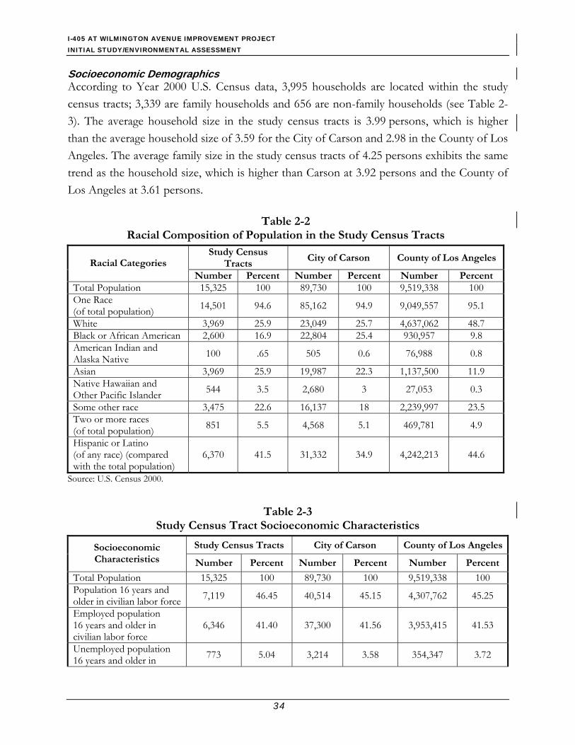
Affected Environment Population Characteristics Year 2000 U.S. Census data from the 3 census tracts (i.e., 5433.03, 5439.03, and 5439.04) that cover the project area were used to characterize population demographic features within the project area. The population of these 3 census tracts is approximately 15,300 residents, which is less than one percent of the population of Carson. Approximately 26 percent of residents within the study census tracts are between the ages of 5 and 19, compared to approximately 11 percent within Carson and the County of Los Angeles. The percentage of residents older than age 65 is almost equal in the study census tracts, as in the city and county.
Table 2-2 presents the racial composition of the population in the study census tracts and the larger region. The study census tracts contain nearly 69 percent in the non-white race category, which is representative of Carson at approximately 69 percent non-white, but it is substantially higher than the County of Los Angeles, which is approximately 46 percent non-white. Out of the non-white population, approximately 42 percent of residents in the study census tracts identify themselves as Hispanic or Latino, which is higher than Carson at 35 percent and slightly lower than the County of Los Angeles at 45 percent. Based on this statistic, the study area is considered a predominantly minority community, as with the larger population within the County of Los Angeles.
I-405 AT WILMINGTON AVENUE IMPROVEMENT PROJECT INITIAL STUDY/ENVIRONMENTAL ASSESSMENT
34
Socioeconomic Demographics According to Year 2000 U.S. Census data, 3,995 households are located within the study census tracts; 3,339 are family households and 656 are non-family households (see Table 2-3). The average household size in the study census tracts is 3.99 persons, which is higher than the average household size of 3.59 for the City of Carson and 2.98 in the County of Los Angeles. The average family size in the study census tracts of 4.25 persons exhibits the same trend as the household size, which is higher than Carson at 3.92 persons and the County of Los Angeles at 3.61 persons.
Table 2-2 Racial Composition of Population in the Study Census Tracts
Study Census Tracts
City of Carson County of Los AngelesRacial Categories Number Percent Number Percent Number Percent
Total Population 15,325 100 89,730 100 9,519,338 100 One Race (of total population) 14,501 94.6 85,162 94.9 9,049,557 95.1
White 3,969 25.9 23,049 25.7 4,637,062 48.7 Black or African American 2,600 16.9 22,804 25.4 930,957 9.8 American Indian and Alaska Native 100 .65 505 0.6 76,988 0.8
Asian 3,969 25.9 19,987 22.3 1,137,500 11.9 Native Hawaiian and Other Pacific Islander 544 3.5 2,680 3 27,053 0.3
Some other race 3,475 22.6 16,137 18 2,239,997 23.5 Two or more races (of total population) 851 5.5 4,568 5.1 469,781 4.9
Hispanic or Latino (of any race) (compared with the total population)
6,370 41.5 31,332 34.9 4,242,213 44.6
Source: U.S. Census 2000.
Table 2-3
Study Census Tract Socioeconomic Characteristics
Study Census Tracts City of Carson County of Los AngelesSocioeconomic Characteristics Number Percent Number Percent Number Percent
Total Population 15,325 100 89,730 100 9,519,338 100 Population 16 years and older in civilian labor force 7,119 46.45 40,514 45.15 4,307,762 45.25
Employed population 16 years and older in civilian labor force
6,346 41.40 37,300 41.56 3,953,415 41.53
Unemployed population 16 years and older in 773 5.04 3,214 3.58 354,347 3.72

I-405 AT WILMINGTON AVENUE IMPROVEMENT PROJECT INITIAL STUDY/ENVIRONMENTAL ASSESSMENT
35
Table 2-3 Study Census Tract Socioeconomic Characteristics
Study Census Tracts City of Carson County of Los AngelesSocioeconomic Characteristics Number Percent Number Percent Number Percent
civilian labor force Individuals in 1999 below Poverty Level 1,745 11.38 8,216 9.15 1,674,599 17.59
Families in 1999 below Poverty Level 317 9.49 1,463 7.09 311,226 14.56
Total Families 3,339 100 20,243 100 2,136,977 100 Average Family Size 4.25 -- 3.92 -- 3.61 -- Median Family Income in 1999 $54,022 -- $54,886 -- $46,452 --
Total Households 3,995 100 24,648 100 3,133,774 100 Average Household Size 3.99 -- 3.59 -- 2.98 -- Median Household Income in 1999 $53,750 -- $52,284 -- $42,189 --
Source: U.S. Census 2000.
As shown in Table 2-3, the median household and family annual incomes for the study census tracts ($54,022 and $53,750) are similar to Carson ($54,866 and $52,284), but they are higher than those for the County of Los Angeles ($46,452 and $42,189). Individual earnings in 1999 below the poverty level (defined as a minimum income level below which a person is officially considered to lack adequate subsistence and to be living in poverty) within the study area census tracts were reported to be 11 percent, which is higher than that of Carson (9 percent) but lower than the County of Los Angeles (18 percent). Family incomes below poverty level within the study census tracts are reported at 9 percent, which is higher than that of Carson (7 percent), but lower than the County of Los Angeles (15 percent).
The HHS establishes the poverty threshold on an annual basis. A family is considered “low-income” if its income is at or below the HHS poverty guidelines. The Year 1999 poverty threshold for an average family size of 4 was $16,700. Based on the HHS thresholds for poverty, the study area is not at the poverty level and is not considered a low-income population.
Environmental Consequences Build Alternatives Title VI of the Civil Rights Act of 1964 mandates that “no person shall, on the grounds of race, color, or national origin, be excluded from participation in, be denied benefits of, or be subjected to discrimination under any program or activity receiving Federal financial assistance.” The Civil Rights Restoration Act of 1987 amended this act by making all federal

I-405 AT WILMINGTON AVENUE IMPROVEMENT PROJECT INITIAL STUDY/ENVIRONMENTAL ASSESSMENT
36
activities, not just those that are federally funded, subject to the mandates of Title VI. The Title VI Policy Statement for this project is included in Appendix F of this document. EO 12898, “Federal Actions to Address Environmental Justice in Minority Populations and Low-income Populations” (February 11, 1994), mandates that federal agencies identify and address disproportionately high and adverse human health or environmental effects of its programs, policies, and activities on minority and/or low-income populations.
According to FHWA Order 6640.23 (1998), a “minority” is an individual classified as Black/African American, Hispanic, Asian and Pacific Islander, American Indian, and other non-white persons. A minority population is defined as any readily identifiable group of minority persons who lives in geographic proximity and, if circumstances warrant, who will be similarly affected by a proposed FHWA program, policy, or activity.
Potential environmental justice impacts are defined as those adverse effects that would be predominantly borne by a minority population and/or low-income population or are greater in magnitude than the adverse effects that would be experienced by non-minority and/or non-low-income population. Although the study census tracts covering the project area contain predominantly minority populations, they are representative of the larger population of Carson. The environmental impacts that would occur because of Alternatives 1 and 2 would be typical for roadway improvement construction in an urban area, regardless of the demographic or socioeconomic characteristics of the community. Construction impacts to various environmental resources, such as air quality, noise, and public utilities, from construction activities would be temporary, and they would be avoided, minimized, or rectified to the extent possible as mitigation for the proposed project. In addition, no land acquisitions would be required of any residential units, public/community service facilities, parks, or schools. The proposed project would not disproportionately affect minority or low-income population compared to the larger population within Carson; therefore, the proposed project would not cause environmental justice impacts per the guidance stipulated in EO 12898.
No-Build Alternative The No-Build Alternative proposes no construction or physical changes in the project area. As a result, no direct effects would occur with the No-Build Alternative implementation.
2.2.4 Avoidance, Minimization, and Compensation Measures The City of Carson in cooperation with Caltrans will implement the following measures:
I-405 AT WILMINGTON AVENUE IMPROVEMENT PROJECT INITIAL STUDY/ENVIRONMENTAL ASSESSMENT
37
• Develop a construction staging plan and a Traffic Management Plan (TMP) that identifies alternate traffic detour routes, bus terminals, transit routes and operation hours, pedestrian routes, and residential and commercial access routes to be used during the construction period. The TMP will consist of the following elements to minimize construction related traffic disruption:
1) Temporary traffic controls and signing shall be utilized 2) The implementation of traffic control procedures will be in conformance with the
Caltrans Traffic Manual. 3) A minimum of one through travel lane in each direction will be provided. 4) Public information center and telephone hotline 5) Additional project signing 6) Advertising in local and regional newspapers Staff attendance at local
neighborhood and business association meetings to inform residents and merchants/landowners of project progress.
• Notify area residents, businesses, and any service providers about the project construction schedule, and assistance programs, traffic-impacted areas, and the TMP at least 2 to 4 weeks in advance of the project construction.
• Arrange with utility providers in advance of the project construction to minimize impacts to public utilities.
• Compensate property owners for any impacts occurred from land acquisitions through the Caltrans ROW appraisal process. Property owners would be compensated with fair market value for their property based on the highest and best use. All benefits and services will be provided equitably to all affected parties without regard to race, color, religion, age, national origins, and disability as specified under Title VI of the Civil Rights Act of 1964.
• Coordinate with UPRR well in advance to determine the construction schedule to avoid disruption of railroad activities.
• Develop and implement a pedestrian traffic detouring plan to ensure the safety of pedestrians, as well as to minimize pedestrian traffic disruption.
• To the extent applicable, arrange the project construction schedule to avoid any two projects in close vicinity to occur simultaneously.
I-405 AT WILMINGTON AVENUE IMPROVEMENT PROJECT INITIAL STUDY/ENVIRONMENTAL ASSESSMENT
38
2.3 Traffic and Transportation/Pedestrian Facilities This section addresses traffic impacts as a result of implementation of the proposed project. The analysis is based on the results of a recent traffic study conducted for the project (Parsons, 2007a).
2.3.1 Regulatory Setting The Department, as assigned by FHWA, directs that full consideration should be given to the safe accommodation of pedestrians and bicyclists during the development of federal-aid highway projects (see 23 CFR 652). It further directs that the special needs of the elderly and the disabled must be considered in all federal-aid projects that include pedestrian facilities. When current or anticipated pedestrian and/or bicycle traffic presents a potential conflict with motor vehicle traffic, every effort must be made to minimize the detrimental effects on all highway users who share the facility.
The Department is committed to carrying out the 1990 Americans with Disabilities Act (ADA) by building transportation facilities that provide equal access for all persons. The same degree of convenience, accessibility, and safety available to the general public will be provided to persons with disabilities.
2.3.2 Affected Environment Current and traffic forecasts at the four intersections along Wilmington Avenue, including 220th Street, I-405 NB on- and off- ramps, I-405 SB on- and off- ramps and 223rd Street, are presented in Section 1.3 of this report.
2.3.3 Environmental Consequences
Build Alternatives Operational Impact The proposed project is an operational improvement project and as such is not forecast to increase traffic volumes. Chapter 1 of this document discusses the existing and forecasted traffic conditions without the proposed project. As shown in Table 1-4, all four intersections are forecasted to operate at LOS F under the No Build Alternative during the peak hours in Year 2030.
A traffic study was conducted to study traffic conditions with implementation of the proposed build alternatives. Based on the new lane configurations (Figures 2-2 and 2-3), the

I-405 AT WILMINGTON AVENUE IMPROVEMENT PROJECT INITIAL STUDY/ENVIRONMENTAL ASSESSMENT
39
proposed project would increase the capacity of the intersections along Wilmington Avenue and thereby reduce V/C ratios (or associated LOS) as demonstrated in Table 2-4 and 2-5.
Table 2-4 Existing and Future Years Forecast Study Intersection LOS
for All Alternatives during AM and (PM) Peak Hours Construction Completion (2011) Future Year (2030) Intersection with
Wilmington Avenue
Existing (2006) No Build
Alt 1
Alt 2
No Build
Alt 1
Alt 2
220th Street C(E) C(F) A(B) A(B) C(F) A(B) A(C) NB Ramps E(F) D(F) B(B) B(B) E(F) B(B) B(B) SB Ramps F(F) F(F) A(B) A(B) F(F) B(B) A(B) 223rd Street F(F) F(F) C(D) C(D) F(F) C(E) C(E)
Source: Parsons, 2007a.
Table 2-5 Comparison of Turn Pocket Length and Freeway Off-Ramp Storage
for Existing, No Build, and Build Alternatives Condition Peak Hour 95th Percentile Queue Lengths in Feet
Existing (2006) Future No Build (2030) Alternative 1 (2030) Alternative 2 (2030) Intersection with
Wilmington Avenue
Storage Length
AM Peak
PM Peak
StorageLength
AM Peak
PM Peak
StorageLength
AM Peak
PM Peak
StorageLength
AM Peak
PM Peak
SB Left at 220th Street 217 81 49 217 117 57 217 77 46 217 77 47 NB Left at 220th Street 56 48 92 56 33 113 100 35 105 131 38 129 SB Left at NB Ramps 149 126 112 149 93 97 100 62 102 - - - NB Off-Ramp 9501 1,178 1,564 12581 641 1,108 12581 208 382 12581 210 354 SB Left at SB Ramps 280 379 868 280 457 1,140 320 85 295 320 81 343 SB Off-Ramp 6081 530 244 6081 780 346 6081 166 112 6081 166 124 SB Left at 223rd Street 203 273 415 203 345 502 205 74 176 205 78 176 NB Left at 223rd Street 221 96 86 221 126 104 151 42 62 151 42 62 Eastbound Left at 223rd Street 299 386 453 299 563 562 290 116 142 290 116 142 Westbound Left at 223rd Street 188 416 453 188 602 562 248 129 187 248 129 187 Bold Type face indicated a queue exceeding storage 1Crosswalk to exit nose
Source: Parsons, 2007a
.
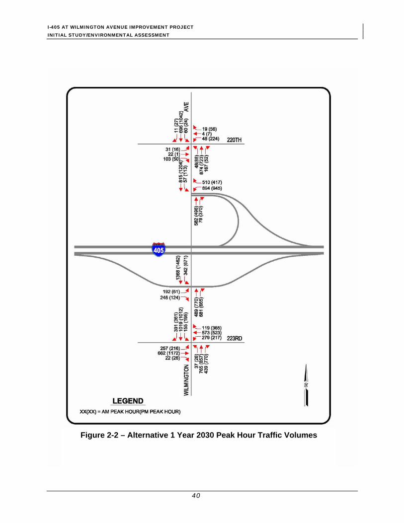
I-405 AT WILMINGTON AVENUE IMPROVEMENT PROJECT INITIAL STUDY/ENVIRONMENTAL ASSESSMENT
40
Figure 2-2 – Alternative 1 Year 2030 Peak Hour Traffic Volumes

I-405 AT WILMINGTON AVENUE IMPROVEMENT PROJECT INITIAL STUDY/ENVIRONMENTAL ASSESSMENT
41
Figure 2-3 – Alternative 2 Year 2030 Peak Hour Traffic Volumes
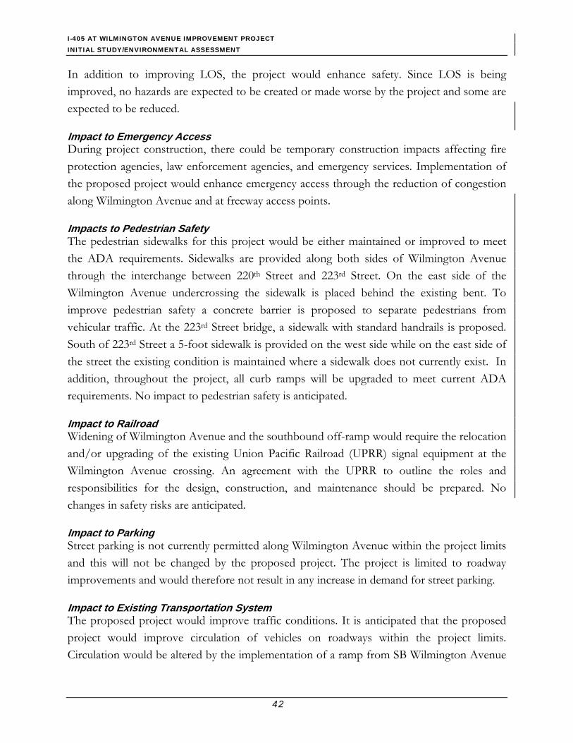
I-405 AT WILMINGTON AVENUE IMPROVEMENT PROJECT INITIAL STUDY/ENVIRONMENTAL ASSESSMENT
42
In addition to improving LOS, the project would enhance safety. Since LOS is being improved, no hazards are expected to be created or made worse by the project and some are expected to be reduced.
Impact to Emergency Access During project construction, there could be temporary construction impacts affecting fire protection agencies, law enforcement agencies, and emergency services. Implementation of the proposed project would enhance emergency access through the reduction of congestion along Wilmington Avenue and at freeway access points.
Impacts to Pedestrian Safety The pedestrian sidewalks for this project would be either maintained or improved to meet the ADA requirements. Sidewalks are provided along both sides of Wilmington Avenue through the interchange between 220th Street and 223rd Street. On the east side of the Wilmington Avenue undercrossing the sidewalk is placed behind the existing bent. To improve pedestrian safety a concrete barrier is proposed to separate pedestrians from vehicular traffic. At the 223rd Street bridge, a sidewalk with standard handrails is proposed. South of 223rd Street a 5-foot sidewalk is provided on the west side while on the east side of the street the existing condition is maintained where a sidewalk does not currently exist. In addition, throughout the project, all curb ramps will be upgraded to meet current ADA requirements. No impact to pedestrian safety is anticipated.
Impact to Railroad Widening of Wilmington Avenue and the southbound off-ramp would require the relocation and/or upgrading of the existing Union Pacific Railroad (UPRR) signal equipment at the Wilmington Avenue crossing. An agreement with the UPRR to outline the roles and responsibilities for the design, construction, and maintenance should be prepared. No changes in safety risks are anticipated.
Impact to Parking Street parking is not currently permitted along Wilmington Avenue within the project limits and this will not be changed by the proposed project. The project is limited to roadway improvements and would therefore not result in any increase in demand for street parking.
Impact to Existing Transportation System The proposed project would improve traffic conditions. It is anticipated that the proposed project would improve circulation of vehicles on roadways within the project limits. Circulation would be altered by the implementation of a ramp from SB Wilmington Avenue

I-405 AT WILMINGTON AVENUE IMPROVEMENT PROJECT INITIAL STUDY/ENVIRONMENTAL ASSESSMENT
43
to NB I-405. Vehicles will enter the ramp by turning right off of Wilmington Avenue. Currently, SB traffic on Wilmington Avenue must turn left to access I-405 NB. The proposed project would improve the LOS at the intersection in the project area, and would result in some travel time savings as demonstrated in Table 1.8 of Section 1.3.3.
Conflict with Adopted Policies, Plans, or Programs Supporting Alternative Transportation A Class I bikeway along Dominguez Channel is shown in the current Transportation/ Circulation Element of the Carson General Plan. The bikeway does not currently exist. The proposed project would potentially widen existing bridges over the channel but, since the bikeway does not currently exist, no impacts are expected as a result of the proposed project. The build alternatives would not impede future bikeway construction along the channel.
The only transit service within the proposed project limits is provided by the Carson Circuit Transit System. The current map of shuttle bus Route F shows a major stop at the intersection of Wilmington Avenue and 223rd Street. That stop is located on 223rd Street west of the bridge over the Dominguez Channel. There is another stop on 220th Street west of Wilmington Avenue. No shelter or other fixed transit facility (except for signs designating stop locations which are mounted on signposts primarily for other signs) currently exists within the proposed project limits, so no impacts are expected as a result of the proposed project.
No-Build Alternative Without implementing the proposed improvements, traffic congestion at the four intersections within the project limits will continue to worsen, as shown in the forecast presented in Section 1.3 (refer to Tables 1-4 and 1-6).
2.3.4 Avoidance, Minimization, and Compensation Measures • In addition to the TMP, a construction management plan will be prepared that
describes construction management activities pertaining to onsite and offsite street circulation, planned haul routes, and temporary traffic lane closures. The construction plans are subject to review by the City.
2.4 Visual and Aesthetic Effects This section analyzes how the proposed project would affect the visual quality of the project roadway corridor and views of the project from the surrounding community. The FHWA
I-405 AT WILMINGTON AVENUE IMPROVEMENT PROJECT INITIAL STUDY/ENVIRONMENTAL ASSESSMENT
44
methodology entitled Visual Impact Assessment for Highway Projects (FHWA, 1981) guidelines were used for conducting the analysis (Parsons, 2007g).
2.4.1 Regulatory Setting The NEPA establishes that the federal government use all practicable means to ensure all Americans safe, healthful, productive, and aesthetically (emphasis added) and culturally pleasing surroundings (42 U.S.C. 4331[b][2]). To further emphasize this point, FHWA in its implementation of NEPA (23 U.S.C. 109[h]) directs that final decisions regarding projects are to be made in the best overall public interest taking into account adverse environmental impacts, including among others, the destruction or disruption of aesthetic values.
Likewise, the CEQA establishes that it is the policy of the state to take all action necessary to provide the people of the state “with…enjoyment of aesthetic, natural, scenic and historic environmental qualities.” (California Public Resources Code Section 21001[b])
2.4.2 Affected Environment The visual environment within the project study area can be divided into three landscape units – Residential, in the northeast quadrant of the interchange; Commercial, in the remaining three quadrants of the interchange; and I-405, which includes the freeway viewshed. I-405 is elevated within the project area over the surrounding landscape (see Figure 2-4). Landscape plantings within the interchange are only partially visible to travelers on the freeway; however, the plantings behind the residential properties help to buffer the homes from the freeway.
Figure 2-4 – Aerial View of the Project Area

I-405 AT WILMINGTON AVENUE IMPROVEMENT PROJECT INITIAL STUDY/ENVIRONMENTAL ASSESSMENT
45
The Residential Unit is made up of smaller 1- and 2-story detached units with both front and backyards. The 2-story residences adjacent to the freeway do not have windows on the freeway side. The homes that are adjacent to I-405 have a 7- to 8-foot block wall located on the homeowners’ side. Views to the freeway are further screened by a row of dense vegetation along the embankment. Homes further back in the development have limited views of the freeway because of the close spacing of the homes and vegetation along the freeway. Typical views within this unit can be seen in Figure 2-5.
Street views, both urban arterial and freeway, dominate the views within the Commercial Landscape Unit, including 223rd Street, Wilmington Avenue, and I-405. The commercial establishments along the arterial roadways are one story structures, many of which cater to automobile traffic. Views to the project area are generally along Wilmington Avenue and from the parking areas associated with the commercial units along Wilmington, as shown in Figure 2-6. On Wilmington Avenue, the views of the I-405 bridge create a focal mid to foreground view as you approach the bridge. Traveling south, the background views are dominated by the refinery, while EB travelers have background views of city development.
The I-405 Landscape Unit includes those views associated with I-405, including views within the interchange ramps. In general, these views include limited foreground views of freeway elements, including paving, roadside barriers, signage, interchange ramps and associated landscaping, and other typical roadway elements; and mid- to background views of adjacent development, particularly the refinery, which dominates many of the background views. Figure 2-7 shows the views along the I-405 Landscape Unit.
Visual Quality
Views from the Residential Landscape Unit to the project area are limited by the existing wall along the property line, the lack of windows facing the project area, and the presence of existing vegetation along the freeway. In general, the view has an overall moderately low visual quality because of the presence of the freeway and the surrounding developments. The intactness of the view is low because of the presence of the freeway with the industrial background. Both the vividness and unity of the views are moderately low and are helped by the presence of the vegetated screen created by the freeway plantings.
Within the Commercial Landscape Unit, views have an overall low visual quality, with a low vividness, intactness, and unity. Vividness is low because of the number of industrial elements within the viewshed, including the refinery, the freeway, and the railroad spur. The

I-405 AT WILMINGTON AVENUE IMPROVEMENT PROJECT INITIAL STUDY/ENVIRONMENTAL ASSESSMENT
46
intactness and unity are affected by many of these same factors, along with the commercial development that creates conflicting patterns of color, line forms, and texture.
Because the interchange is “below” the freeway, many of the interchange elements are not visible to travelers along I-405. The most notable features, other than the ramp gores, are the plantings within the loop ramp in the northeast quadrant and along the freeway east of the I-405 bridge over the Dominguez Channel. The general views within the I-405 Landscape Unit are low with low vividness, intactness, and unity.
Viewer Groups, Exposure, and Awareness In general, the order of “most to least sensitive” viewer groups within the study area are – residents, business owners and employees, shoppers/business users, regular motorists, and occasional motorists.
Residents: The residents in the northeast quadrant of the interchange are likely to have a high concern about the project and its effects on views from their homes and neighborhood. In addition, based on the community plans described above, residents are likely to be concerned about the image of their community as viewed from the freeway. These views are seen by thousands of travelers, both residents and nonresidents, each day for short durations.
Business Owners, Employees, and Customers: Business owners and their employees along Wilmington Avenue have clear views to portions of the project. There are potentially hundreds of views per day for these viewers, both mid-ground and foreground. It is anticipated that these views are of short duration. Employees and customers would likely have a low to moderate awareness of the project, while owners may have a moderate to high awareness of the project because of their concerns over how it might affect business traffic rather than visual quality.
Regular Motorists: This group is primarily made up of local residents who live in the community and regularly use this interchange to access work and home, as well as commuters from outside of the immediate area that regularly pass through the interchange. Wilmington Avenue carries thousands of travelers each day, and volumes on I-405 are much greater with more than 200,000 vehicles per day. During free-flow travel, the project area can be crossed in a few minutes.

I-405 AT WILMINGTON AVENUE IMPROVEMENT PROJECT INITIAL STUDY/ENVIRONMENTAL ASSESSMENT
47
Figure 2-5 Residential Landscape Unit

I-405 AT WILMINGTON AVENUE IMPROVEMENT PROJECT INITIAL STUDY/ENVIRONMENTAL ASSESSMENT
48
This page intentionally left blank

I-405 AT WILMINGTON AVENUE IMPROVEMENT PROJECT INITIAL STUDY/ENVIRONMENTAL ASSESSMENT
49
Figure 2-6
Commercial Landscape Unit

I-405 AT WILMINGTON AVENUE IMPROVEMENT PROJECT INITIAL STUDY/ENVIRONMENTAL ASSESSMENT
50
This page intentionally left blank.
I-405 AT WILMINGTON AVENUE IMPROVEMENT PROJECT INITIAL STUDY/ENVIRONMENTAL ASSESSMENT
51
Figure 2-7 I-405 Landscape Unit

I-405 AT WILMINGTON AVENUE IMPROVEMENT PROJECT INITIAL STUDY/ENVIRONMENTAL ASSESSMENT
52
This page intentionally left blank.
I-405 AT WILMINGTON AVENUE IMPROVEMENT PROJECT INITIAL STUDY/ENVIRONMENTAL ASSESSMENT
53
Daily commuters would be anticipated to have a greater awareness of views within the project area from each of the roadways because of the frequency of traveling the route and the length of time spent on the interchange each day.
Occasional Motorists: This group typically comprises nonresidents passing through the area. These viewers would have a low awareness of the project and any changes to the visual environment. They are more likely to respond to any enhanced visual quality and place identification included in the project.
2.4.3 Environmental Consequences Both NEPA and CEQA require consideration of visual resource impacts of projects in preparation of environmental documents. The CEQA Guidelines (1998) state that a project may have a significant impact on visual quality if it would:
• Have a substantial adverse effect on a scenic vista;
• Substantially damage scenic resources including, but not limited to, trees, rock outcroppings, and historic buildings within a state scenic highway;
• Substantially degrade the existing visual character or quality of the site and its surroundings; or
• Create a new source of substantial light or glare, which would adversely affect day or nighttime views in the area.
For projects that do not create a substantial impact on existing visual quality, a more nuanced approach categorizes impact levels as low, moderate, moderately high, and high based on the following descriptions:
Low: Minor adverse change to the existing visual resource, with low viewer sensitivity to any change. May or may not require mitigation.
Moderate: Adverse change cannot be described as minor or viewer response is thought to be greater. Impacts can be mitigated within 5 years using conventional practices.
Moderately High: Moderate adverse change in the visual resource with high viewer response or high adverse change with a moderate viewer response. Extraordinary mitigation measures may be required, and landscape treatments required may take more than 5 years to mitigate.

I-405 AT WILMINGTON AVENUE IMPROVEMENT PROJECT INITIAL STUDY/ENVIRONMENTAL ASSESSMENT
54
High/Significant: High level of adverse change or a high level of sensitivity to the change such that architectural design and landscape treatments cannot mitigate impacts. An alternative project design may be required to avoid adverse impacts.
For this analysis, the proposed project would be considered to have a substantial impact if it were to result in obstruction or impairment of important views from a public roadway or scenic vista, result in substantial modification to the height of the existing structures/topography of the area, or cause a large reduction in the landscape/vegetation within the interchange area
Build Alternatives Implementation of Alternative 1 would have a low level of visual impact to the project area. Many of the proposed improvements, including improved curb radii, replaced paving, signal improvements, and small roadway widening would not be perceivable by most of the traveling public. The widened cross section of Wilmington Avenue in the area of the Dominguez Channel would be more noticeable, but much of this would be a swapping of parking lot paving with roadway paving; therefore, changes to the existing visual environment would be very small.
Impacts associated with Alternative 2 are similar to Alternative 1. In addition, a new I-405 NB on-ramp would be constructed behind the Residential Landscape Unit. This would require removal of the existing vegetation and construction of soundwalls along I-405 and the ramp. Based on Caltrans’ landscape setback requirements, there would not be sufficient room for new tree plantings within the remaining area between the soundwall and the residents’ property wall; however, vine plantings on the soundwall could be used to soften the appearance and texture of the wall.
Removal of vegetation and the inclusion of soundwalls along the new I-405 NB on-ramp would result in a moderate impact to the visual environment. The impact would not be significant because property perimeter walls partially block views from the adjacent residences and there is a lack of windows on the freeway side of the homes, particularly within the second stories. Figures 2-8 and 2-9 show a “birds-eye” view of the proposed soundwall location from the resident’s point of view.

I-405 AT WILMINGTON AVENUE IMPROVEMENT PROJECT INITIAL STUDY/ENVIRONMENTAL ASSESSMENT
55
Figure 2-8 Proposed View of NB On-Ramp with Soundwalls
(view looking north over the interchange)
Figure 2-9 Proposed View of NB On-Ramp with Soundwalls
(view looking west from the neighborhood)

I-405 AT WILMINGTON AVENUE IMPROVEMENT PROJECT INITIAL STUDY/ENVIRONMENTAL ASSESSMENT
56
No-Build Alternative The No-Build Alternative would not affect views along Wilmington Avenue, or substantially degrade the existing visual character or quality of the site and its surroundings. Nor would it create a new source of light or glare, which would adversely affect day or nighttime views in the area.
2.4.4 Avoidance, Minimization, and Compensation Measures To address the potential adverse visual impacts to the interchange area, the following actions are recommended. With implementation of these mitigation measures, the visual impacts of this project can be reduced and would not result in a substantial change in overall visual quality for the area. The following mitigation proposals are subject to change, especially for the current stage of planning for this project, but necessary aesthetic and landscape mitigation will occur wherever feasible.
• Maximize the use of available landscape areas within the interchange, within established limitations required by Caltrans for planting setbacks. The landscape design should reinforce the design of the architectural elements to create a unified, cohesive design theme.
• Include trees in the new plantings to areas behind the residences to the greatest extent possible to replace those removed by the project.
• Utilize drainage and water quality elements within the interchange that maximize the allowable landscape area.
• Detail soundwalls architecturally to be visually compatible with the adjacent community. Use architectural detailing, such as pilasters, wall caps, and patterns to the block layout or textures to the panels, to enhance the image of the wall.
• Apply architectural detailing to the retaining walls, including textures, colors, and patterns.
• Involve the community in participating in the design process.
• During the final design phase, explore the possibility of placing the right-of-way fencing in visually unobtrusive locations. An aesthetic treatment to the standard chain link fence should be considered for pedestrian traffic areas and highly visible locations, with the agreement that the city will maintain the fencing perpetuity.
I-405 AT WILMINGTON AVENUE IMPROVEMENT PROJECT INITIAL STUDY/ENVIRONMENTAL ASSESSMENT
57
• Provide plantings, where feasible, near the base of the wall, to blend the wall into the surrounding neighborhood.
2.5 Cultural Resources A Historic Property Survey Report (HPSR), Historic Resources Evaluation Report (HRER), and Archaeological Survey Report (ASR) were prepared for the proposed project in March 2007 (ECORP, 2007a-c). These reports were prepared pursuant to the guidelines established in the Caltrans Environmental Handbook, Vol. II (Cultural Resources) issued in June 2006.
2.5.1 Regulatory Setting “Cultural resources” as used in this document refers to all historical and archaeological resources, regardless of significance. Laws and regulations dealing with cultural resources include:
The National Historic Preservation Act of 1966, as amended, (NHPA) sets forth national policy and procedures regarding historic properties, defined as districts, sites, buildings, structures, and objects included in or eligible for the National Register of Historic Places (NRHP). Section 106 of NHPA requires federal agencies to take into account the effects of their undertakings on such properties and to allow the Advisory Council on Historic Preservation the opportunity to comment on those undertakings, following regulations issued by the Advisory Council on Historic Preservation (36 CFR 800). On January 1, 2004, a Section 106 Programmatic Agreement (PA) between the Advisory Council, FHWA, State Historic Preservation Officer (SHPO), and the Department went into effect for Department projects, both state and local, with FHWA involvement. The PA implements the Advisory Council’s regulations, 36 CFR 800, streamlining the Section 106 process and delegating certain responsibilities to the Department. The FHWA’s responsibilities under the PA have been assigned to the Department as part of the Surface Transportation Project Delivery Pilot Program (23 CFR 773) (July 1, 2007).
Historical resources are considered under the CEQA, as well as California Public Resources Code Section 5024.1, which established the California Register of Historical Resources. California Public Resources Code Section 5024 requires state agencies to identify and protect state-owned resources that meet National Register of Historic Places listing criteria. It further specifically requires the Department to inventory state-owned structures in its rights-of-way.
I-405 AT WILMINGTON AVENUE IMPROVEMENT PROJECT INITIAL STUDY/ENVIRONMENTAL ASSESSMENT
58
2.5.2 Affected Environment
Area of Potential Effects The Area of Potential Effects (APE) boundary was established in consultation with Caltrans professionally qualified staff on February 27, 2007. The APE includes the properties from which new ROW would be acquired and adjacent properties subject to indirect effects. The Direct APE includes the maximum extent of ground disturbance from both alternatives.
Archaeological Resources The results of a records search of the South Central Coastal Information Center at California State University, Fullerton conducted on January 29, 2007, revealed that no prehistoric or historic-period archaeological resources were recorded within the APE (ECORP, 2007a) for the proposed project. The results of the Native American Heritage Sacred Lands File Check and consultation with Native Americans did not identify any archaeological or Native American cultural resources within the APE. An archaeological survey was conducted on March 5, 2005. The survey area is the same as the Direct APE, which includes the existing interchange with southbound on- and off-ramps, the area needed for the new northbound on -ramp, and the areas where Wilmington Avenue and 223rd Street would be widened. No prehistoric or historic archaeological resources were identified within the Direct APE, or archaeological APE, during the survey. The APE is almost entirely developed with streets and freeway, industrial and commercial buildings, houses, and parking areas. The only unpaved areas in the Direct APE are adjacent to the SB on- and off-ramps for the current interchange. These areas consist of fill placed during construction of the ramps and are slopes covered with ice plant. Based on this, archaeological impacts are not anticipated and no further archaeological investigations are warranted. However, it is always possible to encounter subsurface archaeological resources in areas where only surface inspection has taken place.
If cultural materials are discovered during construction, all earth-moving activity within and around the immediate discovery area will be diverted until a qualified archaeologist can assess the nature and significance of the find.
If human remains are discovered, State Health and Safety Code Section 7050.5 states that further disturbances and activities shall cease in any area or nearby area suspected to overlie remains, and the County Coroner contacted. Pursuant to Public Resources Code Section 5097.98, if the remains are thought to be Native American, the coroner will notify the

I-405 AT WILMINGTON AVENUE IMPROVEMENT PROJECT INITIAL STUDY/ENVIRONMENTAL ASSESSMENT
59
Native American Heritage Commission (NAHC) who will then notify the Most Likely Descendent (MLD). At this time, the person who discovered the remains will contact Caltrans District 7 Environmental Branch so that they may work with the MLD on the respectful treatment and disposition of the remains. Further provisions of Public Resource Code 5097.98 are to be followed as applicable.
Historic Architectural Resources The records search of the South Central Coastal Information Center at California State University, Fullerton conducted on January 29, 2007, revealed that six buildings are in close proximity to the APE; however, none are within the APE. A review of the Caltrans Historic Bridge Inventory indicates the bridges located within the project APE have been evaluated by Caltrans and determined “not eligible” for the National Register. The records search indicates that no properties within the project APE have been given formal local, state, or national designations of historical significance. Several buildings are currently within the Indirect APE. All of these buildings meet the criteria for the Caltrans Section 106 PA Attachment 4 (Properties Exempt From Evaluation). Therefore, research indicates that no significant “historic properties” as defined by the NHPA or “historical resources” as defined by CEQA are located within the APE.
2.5.3 Environmental Consequences Title 36 CFR Part 800 defines adverse effect on historic properties as follows:
Section 800.5(1), Criteria of Adverse Effect − An adverse effect is found when an undertaking may alter, directly or indirectly, any of the characteristics of a historic property that qualify the property for inclusion in the National Register in a manner that would diminish the integrity of the property’s location, design, setting, materials, workmanship, feeling, or association. Adverse effects on historic properties include, but are not limited to:
• Physical destruction of or damage to all or part of the property
• Alteration of a property, including restoration, rehabilitation, repair, maintenance, stabilization, hazardous material remediation, and provision of handicapped access, that is not consistent with the Secretary of the Interior’s Standards for the Treatment of Historic Properties (1995)
• Removal of the property from its historic location

I-405 AT WILMINGTON AVENUE IMPROVEMENT PROJECT INITIAL STUDY/ENVIRONMENTAL ASSESSMENT
60
• Change of the character of the property’s use or of physical features within the property’s setting that contribute to its historic significance
• Introduction of visual, atmospheric, or audible elements that diminish the integrity of the property’s significant historic features
• Neglect of a property, which causes its deterioration
The CEQA Guidelines state that a project may have a significant effect on the environment if it may “cause a substantial adverse change in the significance of an historical resource” (CEQA Guidelines, Section 15064.5 [b], 2000).
Such changes include “physical demolition, destruction, relocation, or alteration of the resource or its immediate surroundings such that the significance of an historical resource would be materially impaired” (CEQA Guidelines, Section 15064.5 [b][1], 2000).
Build Alternatives The results of a historic architectural survey prepared for this project indicate that there are no buildings determined eligible for inclusion in the NRHP, and none of the properties within the APE had been given formal local designations of historical significance for the purposes of Section 106 of the NHPA or the NEPA. No impacts to significant historical resources are anticipated.
The results of a records search revealed that no archaeological resources were recorded within the APE. A field inspection was conducted, and confirmed that no prehistoric or historic archaeological sites were identified in the APE. Based on this, no archaeological impacts are anticipated and no further archaeological investigations are warranted.
No-Build Alternative No direct or indirect effects to archaeological and historical resources would occur with implementation of the No-Build Alternative.
2.5.4 Avoidance, Minimization, and Compensation Measures In the unlikely event that buried archaeological materials are encountered during excavation and construction, it is Caltrans’ policy to stop work until a qualified archaeologist can evaluate the nature and significance of the find.
In the event human remains are encountered during project construction, the Los Angeles County Coroner shall be contacted to determine whether or not investigation of the cause of

I-405 AT WILMINGTON AVENUE IMPROVEMENT PROJECT INITIAL STUDY/ENVIRONMENTAL ASSESSMENT
61
death is required. Pursuant to Public Resources Code Section 5097.98, if the remains are thought to be Native American, the coroner will notify the NAHC who will then notify the MLD. At this time, the person who discovered the remains will contact Caltrans District 7 Environmental Branch so that they may work with the MLD on the respectful treatment and disposition of the remains.
2.6 Hydrology/Water Quality/Stormwater 2.6.1 Regulatory Setting Water Quality and Stormwater Runoff Section 401 of the Clean Water Act (CWA) requires water quality certification from the State Water Resources Control Board (SWRCB) or from a Regional Water Quality Control Board (RWQCB) when the project requires a CWA Section 404 permit. Section 404 of the CWA requires a permit from the U.S. Army Corps of Engineers (Corps) to discharge dredged or fill material into waters of the United States.
Along with CWA Section 401, CWA Section 402 establishes the National Pollutant Discharge Elimination System (NPDES) permit for the discharge of any pollutant into waters of the United States. The federal Environmental Protection Agency has delegated administration of the NPDES program to the SWRCB and nine RWQCBs. The SWRCB and RWQCB also regulate other waste discharges to land within California through the issuance of waste discharge requirements under authority of the Porter-Cologne Water Quality Act.
The SWRCB has developed and issued a statewide NPDES permit to regulate storm water discharges from all Department activities on its highways and facilities. Department construction projects are regulated under the Statewide permit, and projects performed by other entities on Department right-of-way (encroachments) are regulated by the SWRCB’s Statewide General Construction Permit. All construction projects with 1 acre or more of soil disturbing activities require a Storm Water Pollution Prevention Plan (SWPPP) to be prepared and implemented during construction. Construction activities with less than 1 acre of soil disturbing activities require a Water Pollution Control Program.
Floodplain Executive Order 11988 (Floodplain Management) directs all federal agencies to refrain from conducting, supporting, or allowing actions in floodplains unless it is the only practicable alternative. The FHWA requirements for compliance are outlined in 23 CFR 650 Subpart A.
I-405 AT WILMINGTON AVENUE IMPROVEMENT PROJECT INITIAL STUDY/ENVIRONMENTAL ASSESSMENT
62
In order to comply, the following must be analyzed:
• The practicability of alternatives to any longitudinal encroachments
• Risks of the action
• Impacts on natural and beneficial floodplain values
• Support of incompatible floodplain development
• Measures to minimize floodplain impacts and to preserve/restore any beneficial floodplain values impacted by the project.
The base floodplain is defined as “the area subject to flooding by the flood or tide having a one percent chance of being exceeded in any given year.” An encroachment is defined as “an action within the limits of the base floodplain.”
2.6.2 Affected Environment
Surface Water The project site is located within the Dominguez Watershed, which is part of the Dominguez Channel Hydrologic Unit, Hydrologic Sub-Area (HSA 411.01), and is within the jurisdiction of the Los Angeles RWQCB. The Dominguez Watershed is comprised of approximately 110 square miles of land in the southern portion of Los Angeles County. Approximately 96 percent of the total watershed area is developed and the land use is predominantly transportation. Typically, watersheds are defined by the natural topography of its drainage area; however, the Dominguez Watershed boundary is defined by a network of storm drains and smaller flood control channels. The Dominguez Channel extends from the Los Angeles International Airport to the Los Angeles Harbor and drains large (if not all) portions of the cities of Inglewood, Hawthorne, El Segundo, Gardena, Lawndale, Redondo Beach, Torrance, Carson and Los Angeles. Drainage along the freeway alignment is conveyed towards designed collection facilities and enters the Dominguez Channel through a series of corrugated metal pipes (CMPs), trapezoidal concrete channels, and reinforced concrete pipes (RCPs). The portion of the Dominguez Channel that is adjacent to the project site has rip rap-lined sides and a soft bottom. The remaining land areas within the watershed drain to several debris basins and lakes or directly to the Los Angeles and Long Beach Harbors.

I-405 AT WILMINGTON AVENUE IMPROVEMENT PROJECT INITIAL STUDY/ENVIRONMENTAL ASSESSMENT
63
Within the project limits, Dominguez Channel Estuary (unlined portion below Vermont Ave) is designated as an impaired water body under Section 303(d) of the Clean Water Act (CWA) for several Pollutants of Concern (POCs) which are: Ammonia, Benthic Community Effects, Benzo(a)pyrene Polycyclic Aromatic Hydrocarbons(PAHs), Benzo(a)anthracene, Chlordane (tissue), Chrysene (C1-C4), coliform bacteria, Dichloro-Diphenyl-Trichloroethane (DDT, tissue and sediment), Dieldrin (tissue), Lead (tissue), Polychlorinated biphenyls (PCBs), Phenanthrene, Pyrene, and zinc (sediment). The Dominguez Channel has no established Total Maximum Daily Loads (TMDLs) in effect at this time.
Floodplain Flood plain boundaries were delineated on the Flood Insurance Rate Maps (FIRMs) by the Federal Emergency Management Agency (FEMA). The project area was shown on the FIRM map for this area to lie within Zone A and Zone AR. The two flood zones are defined as follows:
• Zone A – Flood insurance rate zone that corresponds to the 1-percent annual chance floodplains that are determined in the Flood Insurance Study by approximate methods of analysis.
• Zone AR – Flood insurance rate zone used to depict areas protected from flood hazards by flood control structures, such as a levee, that are being restored.
PROJECT AREA
I-405 AT WILMINGTON AVENUE IMPROVEMENT PROJECT INITIAL STUDY/ENVIRONMENTAL ASSESSMENT
64
Groundwater The Dominguez Watershed is underlain by two groundwater basins, the West Coast Basin to the west and south, and the Central Basin to the north and east. The basins are separated by the Newport-Inglewood Fault, although there is some hydraulic connection between them. The proposed project site is located over the West Coast Basin. According to information from the Los Angeles County Department of Public Works (LACDPW), the depth to groundwater at the site area ranges from 6 to 36 feet bgs, near the intersection of Wilmington Avenue and 223rd Street.
According to information from the RWQCB and the California Environmental Protection Agency (Cal-EPA), there are 16 Leaking Underground Storage Tank (LUST) facilities located within a 0.5-mile radius of the project site. Seven of these sites are located upgradient of the project area. Additionally, a 8,330-foot-deep abandoned oil well is located approximately 0.5-mile west of the project area. Since there are many pollutant sources upgradient of the project site, it is likely that the groundwater is contaminated within the project limits.
2.6.3 Environmental Consequences Construction and operational impacts to surface waters were assessed with regard to potential degradation of water quality and changes in surface water flow. Effects on future water quality, both with and without implementation of the project alternatives, were estimated based on the potential for runoff to reach surface water resources and the types of pollutants anticipated.
The proposed project would have significant impacts to water resources during construction and operation, as determined pursuant to CEQA, if any of the following occur:
• Violate any water quality standards or waste discharge requirements (for construction only)
• Substantially degrade water quality
• Substantially deplete groundwater supplies or interfere substantially with groundwater recharge such that there would be a net deficit in aquifer volume or a lowering of the local groundwater table level

I-405 AT WILMINGTON AVENUE IMPROVEMENT PROJECT INITIAL STUDY/ENVIRONMENTAL ASSESSMENT
65
• Substantially alter the existing drainage pattern of the area in a manner that would result in substantial erosion or sedimentation within or downstream of the proposed project area
• Substantially alter the existing drainage pattern of the area or substantially increase the rate or amount of surface runoff in a manner that would result in flooding within or downstream of the project area
• Create or contribute runoff that would exceed the capacity of existing or planned stormwater drainage systems
• Place structures within a 100-year flood hazard area, which would expose people or structures to substantial risk of loss, injury, or death
Build Alternatives The proposed project would not create or contribute runoff that would exceed the capacity of the existing storm water drainage system, or provide substantial additional sources of polluted runoff that would violate or be inconsistent with any federal, State or local water quality standards. The proposed project would not substantially alter the existing drainage pattern and would not substantially deplete groundwater supplies or interfere with groundwater recharge. The proposed project will place piles in the Dominguez Channel; however, through the hydrologic analysis performed as part of the Hydrology, Floodplain, Water Quality, and Stormwater Runoff Impact Analysis (Parsons 2007d), it has been determined that this would not substantially impede or redirect the flow, or exceed the capacity of the channel.
The proposed project will encroach upon a floodplain; however, flooding in this area is typically confined to the Dominguez Channel, and structures that will be utilized to facilitate bridge widening are designed to be placed in the flow line. This would not result in the exposure of people or structures to a significant risk of loss, injury, or death involving flooding. Short-term water quality impacts would occur during construction of the proposed project; however, no adverse impacts to water quality from construction are anticipated. No adverse impacts to water quality from operations are anticipated, so long as the proper BMPs or media filters are utilized.
Construction of the proposed retaining wall would require excavation of the soil to the depth of approximately six feet below ground surface. Groundwater may be encountered and dewatering may be required. Since groundwater at the project site is likely to be

I-405 AT WILMINGTON AVENUE IMPROVEMENT PROJECT INITIAL STUDY/ENVIRONMENTAL ASSESSMENT
66
contaminated, testing of groundwater to identify appropriate handling and disposal method would be required. Piles installation as part of bridge construction would not require groundwater dewatering because the Cast in Steel Shell (CISS) pile is proposed to be used and the piles would penetrate through groundwater. With the proper handling of groundwater during the dewatering process, no impacts to any surface water or groundwater are anticipated as a result of dewatering operations.
No-Build Alternative No direct or indirect effects to water resources would be expected to occur under the No-Build Alternative.
2.6.4 Avoidance, Minimization, and Compensation Measures • Under Section 402(p) of the Water Quality Protection Act of 1987, the project must
conform to the requirements of Caltrans’ Statewide NPDES Permit, Order No. 99-06-DWQ, NPDES No. CAS000003 in addition to the BMPs specified in Caltrans’ Statewide Storm Water Management Plan (SWMP). Since the proposed project is subject to the Caltrans’ Statewide NPDES Permit, permanent Treatment Best Management Practices (BMPs) would be incorporated into the project to the Maximum Extent Practicable (MEP) during the project planning and design process.
• When applicable, the project must also conform to the requirements of the General NPDES Permit for Construction Activities, Order No. 99-08-DWQ, NPDES No. CAS000002, and any subsequent general permit in effect at the time of project activity. RWQCB administers and enforces the General Permit program. The objectives of the General Permit are:
- To identify pollutant sources that may affect the quality of discharges of stormwater associated with construction activity from the project site; and
- To identify, construct, and implement stormwater pollution preventive measures and BMPs to reduce pollutants in stormwater discharges from the construction site both during construction and after construction is completed.
• The City is required to ensure that an Stormwater Pollution Prevention Plan (SWPPP) and Monitoring Program are prepared and implemented prior to

I-405 AT WILMINGTON AVENUE IMPROVEMENT PROJECT INITIAL STUDY/ENVIRONMENTAL ASSESSMENT
67
construction activities. The contractor shall develop a SWPPP to incorporate federal, State, and resource agency approved methodologies as well as all other appropriate techniques for reducing impacts to water quality. The plan shall incorporate control measures in the following categories: soil stabilization practices; sediment control practices; sediment tracking control practices; wind erosion control practices; and non-storm water management and waste management and disposal control practices. The plan shall be approved by Caltrans prior to project construction and implementation.
• The contractor shall be required to comply with water pollution control provisions and the SWPPP and conform to the requirements of the Caltrans Standard Specifications Section 7-1.01G “Water Pollution,” of the Standard Specifications.
• Appropriate BMPs will be obtained from the Caltrans Storm Water Quality Handbook Project Planning and Design Guide (Caltrans, May 2007) and the Construction Site Best Management Practices Manual (Caltrans, March 2003). The following special BMPs shall be considered for implementation to prevent debris falling and depositing in the Dominguez Channel because of construction over the channel:
− Limit demolition and construction located over the channel to the dry season (April to October).
− Employ nonshattering methods for demolition activities (e.g., wrecking balls would not be acceptable).
− Place platforms under/adjacent to the bridge structures to collect debris.
− Secure all materials on bridge structures to prevent discharges being carried into the channel by the wind.
− Use attachments on equipment, such as backhoes, to catch debris from small demolition operations.
− Stockpile accumulated debris and waste generated from demolition away from the channel.
− Use drip pans during equipment operation, maintenance, cleaning, fueling, and storage for spill prevention. Place drip pans under all vehicles and equipment placed on the bridge structures when expected to be idle for more than 1 hour.
− Keep equipment used in the channel free of leak.

I-405 AT WILMINGTON AVENUE IMPROVEMENT PROJECT INITIAL STUDY/ENVIRONMENTAL ASSESSMENT
68
− Direct water from concrete curing and finishing operations away from inlets and watercourses to collection areas for dewatering.
− Re-vegetating disturbed slopes following Caltrans policies and procedures
− Rounding slopes and benches to reduce concentrated flows, and preserving existing vegetation as much as possible to minimize erosion (Parsons, 2008).
− Rip-rap and culverts with flared end sections would be implemented, where possible, to reduce concentrated flows and limit erosion
• With the incorporation of a Treatment BMP strategy, it is estimated that 100 percent of the Water Quality Volume/Water Quality Flow (WQV/WQF) generated by the entire project will be treated. Within the project limits, the existing paved surface area is measured to be 3.16 acres. The proposed project is expected to add an additional 2.04 acres of paved surface area. The proposed Treatment BMPs, consisting of three Biofiltration Swales and one Media Filter are estimated to treat runoff from 14.5 acres of impervious surface, which would handle 100 percent of the maximum WQV/WQF. The proposed devices can also treat the flows from 9.3 acres of impervious surface outside the project limits. The Targeted Design Constituents (TDCs) identified for the project area are total lead, dissolved lead, total zinc, dissolved zinc, and sediments. Site criteria such as soil types and depth to groundwater indicate that a Media Filter and Biofiltration Swales are the most feasible Treatment BMPs to implement for this project for the removal of total lead, dissolved lead, total zinc, dissolved zinc, and sediments from stormwater runoff.
• Install a groundwater monitoring well near the retaining wall to test soils and groundwater quality. If the groundwater is contaminated, the contractor shall be required to dispose of the groundwater in accordance with the current regulatory requirements.
2.7 Topography, Geology, Soils, and Seismicity 2.7.1 Regulatory Setting For geologic and topographic features, the key federal law is the Historic Sites Act of 1935, which establishes a national registry of natural landmarks and protects “outstanding examples of major geological features.” Topographic and geologic features are also protected under the CEQA.
This section also discusses geology, soils, and seismic concerns as they relate to public safety and project design. Earthquakes are prime considerations in the design and retrofit of structures. The Department’s Office of Earthquake Engineering is responsible for assessing

I-405 AT WILMINGTON AVENUE IMPROVEMENT PROJECT INITIAL STUDY/ENVIRONMENTAL ASSESSMENT
69
the seismic hazard for Department projects. The current policy is to use the anticipated Maximum Credible Earthquake (MCE), from young faults in and near California. The MCE is defined as the largest earthquake that can be expected to occur on a fault over a particular period of time.
2.7.2 Affected Environment
Topography The topography of the project site is a relatively flat coastal plain underlain by unconsolidated alluvial sediments deposited in recent time by the Los Angeles River. Site geology, seismicity, and soil condition were reviewed and summarized as part of the Preliminary Foundation Study (Converse Consultant, 2007).
Geology and Soils The project site lies along the southern margin of the Los Angeles Basin in the Peninsular Ranges Geomorphic Province of California. The Peninsular Ranges province is characterized by northwest trending valleys and mountain ranges which have formed in response to regional tectonic forces along the boundary between the Pacific and North American tectonic plates. The geologic structure is dominated by northwest trending right-lateral faults, most notably, the San Andreas, San Jacinto, Elsinore, Whittier and Newport-Inglewood faults. The province extends southward from the Transverse Ranges province at the north end of the Los Angeles basin to the southern tip of the Baja California Peninsula.
The project is located on a broad sediment-filled basin along the southern edge of the Los Angeles Coastal Plain within the Dominguez Gap. The coastal basin has been gradually filled with Quaternary-age marine and non-marine sediments. The Los Angeles River deposited stream and flood plain sediments across the coastal plain during recent time to form a relatively flat and broad river flood plain through the Dominguez Gap to the Pacific Ocean. Soils underlying the project site consist of alluvial sand, silt and clay sediments. Most of these natural river and stream channels are now controlled by dams and flood control channels that collect surface runoff and convey storm water runoff to the ocean.
The I-405/Wilmington Avenue interchange is located at an approximate ground surface elevation of 24 feet above mean sea level (MSL). Wilmington Avenue crosses below the I-405 freeway bridge overcrossing. The I-405 over-crossing and access ramps have been built-up with artificial fill soils placed on top of natural alluvial sediments. The raised ground

I-405 AT WILMINGTON AVENUE IMPROVEMENT PROJECT INITIAL STUDY/ENVIRONMENTAL ASSESSMENT
70
surface elevations for the built-up access ramps and I-405 freeway range in elevation from 24 feet to 47 feet above MSL.
Borings drilled at the project site indicate that the site is underlain by 5 feet to 20 feet of fill and fine-grained alluvium including clays, silts and silty sand and sands (Converse Consultant, 2007). The soils consist of soft plastic clay to stiff silty clay, loose to slightly compact silts and loose to dense silty sands and sands.
Based on the Open File Report 98-19 for Long Beach Quadrangle, the historical high groundwater table in the project vicinity is about 20 feet below ground surface (bgs). Based on the available logs of test boring data, the depth of groundwater in the channel vicinity is about 15 feet to 25.5 feet bgs. It should be noted that the borings might not have been left open for a sufficient period of time to establish equilibrium groundwater conditions. In addition, fluctuations in the groundwater level could occur due to change in seasons, variations in rainfall, and other groundwater basin factors.
The groundwater level beneath the site can vary depending upon the water level in the Dominguez Channel and upon the seasonal precipitation and groundwater basin activities including groundwater recharge, storage and pumping occurring in the general site vicinity.
Seismicity The project site is located in a seismically active area. The geologic processes that have caused earthquake events and strong ground shaking in the past can be expected to continue.
A fault is considered by the State of California to be active if geologic evidence indicates that movement on the fault has occurred in the last 11,000 years, and potentially active if movement is demonstrated to have occurred in the last 2 million years.
The project site is not located within a currently designated State of California Earthquake Fault Zone for surface fault rupture. No surface faults are known to project through or towards the site. The closest known faults to the project site are the Newport Inglewood fault, Palos Verdes fault, concealed Puente Hills Blind Thrust fault and Whittier fault.
The closest known surface trace of an active fault to the project site is the Newport Inglewood fault zone located about 2 miles east of the project site. The Newport Inglewood fault is about 41 miles long on shore and extends northwest from Huntington Beach

I-405 AT WILMINGTON AVENUE IMPROVEMENT PROJECT INITIAL STUDY/ENVIRONMENTAL ASSESSMENT
71
through Long Beach to Culver City and the Cheviot Hills. The Newport Inglewood fault continues offshore to the southeast of Huntington Beach and makes landfall in La Jolla as the Rose Canyon fault. The Newport Inglewood fault is characterized by a series of uplifted and folded hills and mesas, including Newport Mesa, Huntington Beach Mesa, Bolsa Chica Mesa, Alamitos Heights and Landing Hill, Signal Hill and Reservoir Hill, Dominguez Hills, and Baldwin Hills.
Several earthquakes have occurred along the fault zone including the March 10, 1933 “Long Beach” earthquake of Richter magnitude (M) 6.4, with its epicenter off Newport Beach, and smaller earthquakes at Inglewood on June 20, 1920 (M 4.9), and Gardena on November 14, 1941 (M 5.4). These faults show evidence of right-lateral strike slip focal mechanisms and stress fields. No historical earthquake is known to have been accompanied by surface rupture.
The Newport Inglewood fault is considered to be active and considered capable of producing a maximum moment magnitude (Mw) 7.1 earthquake. The slip rate is considered to be about 1.0 mm/year but may range up to 2 to 3 mm/year. The orientation of structural elements of the Newport Inglewood fault zone is generally attributed to right-lateral, en-echelon, strike-slip faulting at depth.
Seismic Hazards The project site is situated in a seismically active region. As is the case for most areas of Southern California, ground-shaking resulting from earthquakes associated with nearby and more distant faults may occur at the project site. During the life of the project, seismic activity associated with active faults can be expected to generate moderate to strong ground shaking at the site.
According to the California Building Code (2001), the proposed site is located in Seismic Zone 4. Seismic Zone 4 includes those areas of California that have experienced major (Richter magnitude greater than 7) historic earthquakes and high levels of recent seismicity. Major damage corresponding to intensities VIII or higher on the Modified Mercalli Intensity Scale should be expected within this zone.
The State of California Seismic Hazard Zone Map for the Long Beach Quadrangle (March 25, 1999) does show the project site located within an area of potential liquefaction. The

I-405 AT WILMINGTON AVENUE IMPROVEMENT PROJECT INITIAL STUDY/ENVIRONMENTAL ASSESSMENT
72
project site is not shown with any earthquake-induced landslide areas due to the relatively flat condition of the site topography.
Review of recent seismological and geophysical publications indicates that the seismic hazard for the project site still remains high.
2.7.3 Environmental Consequences The potential for geological hazard impacts from the proposed project would be considered significant pursuant to CEQA if the project would:
• Expose people or structures to substantial adverse effects, including the risk of loss, injury, or death involving strong seismic shaking or seismic-related ground failure, including liquefaction.
• Be located on a geologic unit or soil type that is unstable, or that could become unstable as a result of the project, and potentially result in landslides, lateral spreading, subsidence, liquefaction, or collapse.
• Result in substantial soil erosion or loss of topsoil.
Build Alternatives The project site is situated in a seismically active region. As is the case for most areas of Southern California, ground-shaking resulting from earthquakes associated with nearby and more distant faults may occur at the project site. During the life of the project, seismic activity associated with active faults can be expected to generate moderate to strong ground shaking at the site.
According to the California Building Code (2001), the proposed site is located in Seismic Zone 4. Seismic Zone 4 includes those areas of California that have experienced major (Richter magnitude greater than 7.0) historic earthquakes and high levels of recent seismicity. Major damage corresponding to intensities VIII or higher on the Modified Mercalli Intensity Scale should be expected within this zone.
The State of California Seismic Hazard Zone Map for the Long Beach Quadrangle (March 25, 1999) does show the project site located within an area of potential liquefaction. The project site is not shown with any earthquake-induced landslide areas due to the relatively flat condition of the site topography.
I-405 AT WILMINGTON AVENUE IMPROVEMENT PROJECT INITIAL STUDY/ENVIRONMENTAL ASSESSMENT
73
Review of recent seismological and geophysical publications indicates that the seismic hazard for the project site still remains high.
Secondary effects of seismic activity include surface fault rupture, soil liquefaction, lateral spreading, landslides, and earthquake-induced flooding, Site-specific potential for each of these seismic hazards is discussed in the following paragraphs.
Surface Fault Rupture: The site is not located within a currently designated State of California Earthquake Fault Zone. Based on a review of existing geologic information, no known active surface fault zone crosses or projects toward the site. The potential for surface rupture resulting from the movement of the nearby major faults is not known with certainty but is considered very low.
Liquefaction: Liquefaction is defined as the phenomenon in a soil mass, due to the development of excess pore pressures, suffers a substantial reduction in its shear strength to a constant value and deforms continuously until the imposed shear stresses become equal to steady-state shear strength. During earthquakes, excess pore pressures in saturated soil deposits may develop as a result of induced cyclic shear stresses resulting in liquefaction.
Review of the State of California Seismic Hazard Zones Map for the Long Beach Quadrangle released March 25, 1999 shows that the proposed project site is located within a potential liquefaction zone.
Liquefaction analysis was conducted based on “Recommended Procedures for Implementation of State Mining and geology Board Special Publication 117 Guidelines for Analyzing and Mitigating Liquefaction in California, March 1999.” Available logs of test borings were used for liquefaction analysis. Based on the liquefaction analysis the subject onsite soil was determined to have a low susceptibility to liquefaction under earthquake ground shaking.
Lateral Spreading: Seismically induced lateral spreading involves primarily lateral movement of earth materials due to ground shaking. It differs from slope failure in that complete ground failure involving large movement does not occur due to the relatively smaller gradient of the initial ground surface. Lateral spreading is demonstrated by near-vertical cracks with predominantly horizontal movement of the soil mass involved. The topography at the project site and in the immediate vicinity of the site is very flat. Under these circumstances, the potential for lateral spreading at the subject site is considered low.

I-405 AT WILMINGTON AVENUE IMPROVEMENT PROJECT INITIAL STUDY/ENVIRONMENTAL ASSESSMENT
74
Landslides: Seismically induced landslides and other slope failures are common occurrences during or soon after earthquakes. The project site is very flat. In the absence of significant ground slopes, the potential for seismically induced landslides to affect the proposed site is considered extremely low.
Earthquake-Induced Flooding: This is flooding caused by failure of dams or other water-retaining structures as a result of earthquakes. The potential of earthquake induced flooding of the subject site is considered to be low because there is no dam located in the project vicinity.
The proposed project will be built to current earthquake standards and will use best engineering practices to minimize damage from ground shaking. These standards have been established to reduce the damage from seismic activity, which will reduce the potential for impacts to the public.
No-Build Alternative Under the No-Build Alternative, the risk of exposing people or structures to potential substantial adverse effects as a result of seismic activities and seismic-related ground failure within the project area would remain the same.
2.7.4 Avoidance, Minimization, and Compensation Measures All applicable Caltrans seismic requirements would be adhered to; therefore, no mitigation measures are required.
2.8 Paleontology 2.8.1 Regulatory Setting Paleontology is the study of life in past geologic time based on fossil plants and animals. A number of federal statutes specifically address paleontological resources, their treatment, and funding for mitigation as a part of federally authorized or funded projects. (e.g., Antiquities Act of 1906 [16 USC 431-433], Federal-Aid Highway Act of 1935 [20 USC 78]). Under California law, paleontological resources are protected by the CEQA, the California Code of Regulations, Title 14, Division 3, Chapter 1, Sections 4307 and 4309, and Public Resources Code Section 5097.5.
I-405 AT WILMINGTON AVENUE IMPROVEMENT PROJECT INITIAL STUDY/ENVIRONMENTAL ASSESSMENT
75
2.8.2 Affected Environment The results of the paleontological literature review indicate that the project APE contains imported fill and Younger and Older Quaternary Alluvium (ECORP, 2007b). Imported fill and the Younger Quaternary Alluvium which is found near the ground surface do not contain vertebrate fossils. However, the deeper Older Quaternary Alluvium has produced four vertebrate fossils depths ranging from 10 to 30 feet below the surface in the vicinity of the proposed project area. The Older Quaternary Alluvium within the Los Angeles Basin is considered highly fossiliferous.
The maximum proposed depth of ground disturbance is 21 feet below the original ground at the beginning of the new northbound on-ramp. The depth of the ground disturbance for the roadway improvements in Wilmington Avenue and 223rd Street will be approximately 3 feet. In addition, excavations for the structure footings, pile tips or underground utilities might be deeper. Ground disturbance within the direct APE will likely encounter the Older Quaternary Alluvium.
2.8.3 Environmental Consequences
Build Alternatives The results of the paleontological literature review indicate that substantive subsurface excavation within the boundaries of the project APE has the potential to expose significant nonrenewable paleontological resources. Vertebrate fossils have been encountered within the Older Quaternary Alluvium at depths ranging from 10 to 30 feet below the surface in the vicinity of the proposed project area. Ground disturbance is anticipated within the Older Quaternary Alluvium. Therefore, a qualified vertebrate paleontologist is required to develop a monitoring program to mitigate the impacts to nonrenewable paleontological resources. The monitoring program may include monitoring of initial grading activities, as well as recovery, preparation (to a point of identification), cataloguing, and curation of fossil materials. Also, a preconstruction meeting would be conducted in which the project paleontologist will explain the procedures necessary to protect and safely remove potentially significant fossil materials for study and curation. The methods employed during monitoring, and/or recovery of fossil specimens should be documented in a report of findings. Any fossils that are collected should be inventoried and placed in an accredited scientific institution for curation. These measures would reduce any potential impacts to significant nonrenewable paleontological resources to less than significant.

I-405 AT WILMINGTON AVENUE IMPROVEMENT PROJECT INITIAL STUDY/ENVIRONMENTAL ASSESSMENT
76
No-Build Alternative No direct or indirect effects to paleontological resources would occur with implementation of the No-Build Alternative.
2.8.4 Avoidance, Minimization, and Compensation Measures Excavation into previously undisturbed older subsurface sediments should be monitored by a qualified paleontological monitor. The monitor will have the authority to divert grading away from exposed fossil resources temporarily in order to recover the fossils specimens and contextual data. Fossils recovered will be prepared, identified, and cataloged before donation to the accredited repository designated by the City of Carson. The paleontological principal investigator will prepare a final report which will include a list of resources recovered, documentation of each locality, and interpretation of resources recovered.
2.9 Hazardous Materials/Waste 2.9.1 Regulatory Setting Hazardous materials and hazardous wastes are regulated by many state and federal laws. These include not only specific statutes governing hazardous waste, but also a variety of laws regulating air and water quality, human health and land use.
The primary federal laws regulating hazardous wastes/materials are the Resource Conservation and Recovery Act of 1976 (RCRA) and the Comprehensive Environmental Response, Compensation and Liability Act of 1980 (CERCLA). The purpose of CERCLA, often referred to as Superfund, is to clean up contaminated sites so that public health and welfare are not compromised. RCRA provides for “cradle to grave” regulation of hazardous wastes. Other federal laws include:
• Community Environmental Response Facilitation Act (CERFA) of 1992
• Clean Water Act
• Clean Air Act
• Safe Drinking Water Act
• Occupational Safety and Health Act (OSHA)
• Atomic Energy Act
• Toxic Substances Control Act (TSCA)
• Federal Insecticide, Fungicide, and Rodenticide Act (FIFRA)
I-405 AT WILMINGTON AVENUE IMPROVEMENT PROJECT INITIAL STUDY/ENVIRONMENTAL ASSESSMENT
77
In addition to the acts listed above, Executive Order 12088, Federal Compliance with Pollution Control, mandates that necessary actions be taken to prevent and control environmental pollution when federal activities or federal facilities are involved.
Hazardous waste in California is regulated primarily under the authority of the federal Resource Conservation and Recovery Act of 1976, and the California Health and Safety Code. Other California laws that affect hazardous waste are specific to handling, storage, transportation, disposal, treatment, reduction, cleanup and emergency planning.
Worker health and safety and public safety are key issues when dealing with hazardous materials that may affect human health and the environment. Proper disposal of hazardous material is vital if it is disturbed during project construction.
2.9.2 Affected Environment An Initial Site Assessment (ISA) was performed for this project during the Project Study Report preparation phase of development (MCE Group, 2003). The updated ISA was performed in October 2007 (Converse Consultant, 2007). The updated ISA confirmed the information presented in the original ISA, and recommended a site investigation be conducted to determine if hazardous wastes such as aerially deposited lead, petroleum hydrocarbons, volatile organic compounds or pesticides exist within the project area that is proposed to have existing soil disturbed.
The Site Investigation was conducted following the approval of a work plan by the Hazardous Waste Section of Caltrans in April 2008. The scope of the SI included collection of 23 soil samples from the proposed excavation area of the proposed project to analyze for aerially deposited lead (ADL) (23 samples), asbestos (5 samples), pesticides and herbicides (11 samples), Title 22 Metals (7 samples), and pH (8 samples). Four additional borings within the project site were drilled to collect soil and groundwater samples to test for hydrocarbons. In addition, six bulk paint samples from the asphalt removal areas within the project site were collected to test for lead and chromium content. Detailed sampling methodologies, analytical methods, and analytical results are presented in the Site Investigation Report (Converse Consultant, 2008).
Based on the results of soil and groundwater analysis; the site conditions are summarized below:

I-405 AT WILMINGTON AVENUE IMPROVEMENT PROJECT INITIAL STUDY/ENVIRONMENTAL ASSESSMENT
78
• Soil samples from the top 6 inches from ground surface were report to contain lead at the concentrations to be classified as California hazardous waste.
• Samples of yellow and white paint stripe were reported to contain lead and chromium at the levels to be classified as California hazardous waste.
• Asbestos was reported below the detection limits in soil samples.
• Metals from soil samples were detected at concentrations below the regulatory limits.
• One out of 11 soil samples contains pesticides at the level slightly above current regulatory limit and should be classified as California hazardous waste.
• Some soil and groundwater samples collected from the location near southbound off-ramp of I-405 were reported to contain Total Petroleum Hydrocarbon (TPH) and Volatile Organic Compounds (VOCs) at the level above the maximum concentration levels set forth by the Los Angeles Regional Water Quality Control Board (RWQCB).
Aside from soil and groundwater sampling, asbestos containing materials (ACMs) were investigated. ACMs were detected at a few locations including freeway overpass at Wilmington Avenue (white mastic around the based of the nuts/screws to the guard rail supports and gaskets underneath the guard rail supports) and the cement pipe covering at the underpass of 223rd Street Bridge.
2.9.3 Environmental Consequences The proposed project may result in significant impacts, as determined pursuant to CEQA, if it would:
• Create a significant hazard to the public or environment through the routine transport, storage, use, or disposal of hazardous materials
• Create a significant hazard to the public through reasonably foreseeable upset and accident conditions involving the release of hazardous materials into the environment
• Be located within 0.4-km (0.25-mi) of a site that emits hazardous emissions or handles hazardous or acutely hazardous materials, substances, or wastes

I-405 AT WILMINGTON AVENUE IMPROVEMENT PROJECT INITIAL STUDY/ENVIRONMENTAL ASSESSMENT
79
• Be located on a site that is known to contain hazardous materials or is listed pursuant to Government Code Section 65962.5 and, as a result, could create a significant hazard to the public or the environment
Build Alternatives Based on the results of the site investigation, soil in certain parts of the project site has the potential to be contaminated with ADL, pesticides, and TPH. In addition, groundwater within the project site may contain TPH and VOC at the level above the maximum concentration levels set forth by the RWQCB. In addition, some gasket and piping materials within the project site were tested to contain ACMs. These hazardous materials could affect the environmental quality and worker health and safety if not properly handled.
No-Build Alternative No direct or indirect effects would occur under the No Build Alternative.
2.9.4 Avoidance, Minimization, and Compensation Measures • All contaminated soils shall be treated in conformance with the current regulatory
guidelines.
• Specifications for the removal of asbestos, suspected meals coated with lead-based paint, and other hazardous substances, if encountered during construction, shall be included in the project.
• All litter and solid waste will be taken to an approved disposal facility.
• Prior to the construction phase, conduct soil sampling at the location near the loop on-ramp area to delineate the lateral and vertical extent of the pesticide impacted soils. Handling of impacted soils in accordance with current regulatory guidelines.
• Prior to the construction phase, conduct soil sampling at the location near southbound off-ramp of I-405 to define the lateral extent of the TPH impacted soils. Handling of impacted soils in accordance with current regulatory guidelines.
• If groundwater is encountered during the construction phase, the contractor shall be required to handle the impacted groundwater in accordance with the current regulatory guidelines.

I-405 AT WILMINGTON AVENUE IMPROVEMENT PROJECT INITIAL STUDY/ENVIRONMENTAL ASSESSMENT
80
• The contractors shall prepare a project-specific Lead Compliance Plan (CCR Title 8, Section 1532.1, the Lead in Construction Standard) to minimize worker exposure to lead impacted soil.
• If grinding of the yellow and white stripe is required, the contractors shall prepare a Health and Safety Plan to minimize worker exposure.
2.10 Air Quality An air quality assessment was prepared for the proposed project (Parsons, 2007b). Information related to air quality regulations and study methodology can be found in the Air Quality Technical Report, which is incorporated by reference into this IS/EA with MND and FONSI document.
2.10.1 Regulatory Setting A number of statutes, regulations, plans, and policies have been adopted that address air quality issues. The proposed project site and vicinity are subject to air quality regulations developed and implemented at the federal, state, and local levels. Plans, policies, and regulations that are relevant to the proposed project are discussed in the following sections.
Federal Regulations/Standards The federal Clean Air Act (CAA) was passed in 1970, and last amended in 1990. It forms the basis for the national air pollution control effort. Basic elements of the act include national ambient air quality standards (NAAQS) for criteria air pollutants, hazardous air pollutants emission standards, state attainment plans, motor vehicle emissions standards, stationary source emission standards and permits, acid rain control measures, stratospheric ozone (O3) protection, and enforcement provisions.
The NAAQS have two tiers: primary standards to protect public health and secondary standards to prevent environmental degradation (e.g., damage to vegetation and property, visibility impairment). The CAA mandates that the state submit and implement a State Implementation Plan (SIP) for areas not meeting the NAAQS. These plans must include pollution control measures that demonstrate how the standards will be met.
The 1990 Amendments to the CAA identify specific emission reduction goals for areas not meeting the NAAQS. These amendments require both a demonstration of reasonable progress toward attainment and incorporation of additional sanctions for failure to attain or
I-405 AT WILMINGTON AVENUE IMPROVEMENT PROJECT INITIAL STUDY/ENVIRONMENTAL ASSESSMENT
81
to meet interim milestones. The sections of the CAA that are most applicable to the project include Title I (Nonattainment Provisions) and Title II (Mobile Source Provisions).
Title I of the CAA identifies attainment, nonattainment, and unclassifiable areas with regard to the criteria pollutants, and it sets deadlines for all areas to reach attainment for the following criteria pollutants: O3; nitrogen dioxide (NO2); sulfur dioxide (SO2); particulates less than ten microns in diameter (PM10); carbon monoxide (CO); and lead (Pb). The NAAQS were amended in July 1997 to include the 8-hour O3 standard and an NAAQS for fine particulates less than 2.5 microns in diameter (PM2.5).
Title II of the CAA contains a number of provisions with regard to mobile sources, including motor vehicle emission standards (e.g., new tailpipe emissions standards for cars and trucks, nitrogen oxides [NOX] standards for heavy-duty vehicles), fuel standards (e.g., requirements for reformulated gasoline), and a program for cleaner fleet vehicles.
The United States Environmental Protection Agency (EPA) reviews the most update scientific information and the existing ambient standard for each pollutant, every five years, and obtains advice from the Clean Air Scientific Advisory Committee on each review. Based on these, EPA applies consideration to revise NAAQS accordingly. The NAAQS for particulate matters were amended in September 2006 to strengthen the 24-hour PM2.5 standard and revoke the annual PM10 NAAQS, due to a lack of evidence linking health problems to long-term exposure to coarse particulate pollution. EPA had revised the ozone standard in 1997, setting the 8-hour standard at 0.08 parts per million (ppm). On March 12, 2008 EPA strengthened the 8-hour O3 NAAQS based on new scientific evidence about the effects of ground-level ozone on public health and the environment. The new standard (primary and secondary) is 0.075 ppm. The area designation/ classification based on the new standard will become effective within two years, (i.e., March 2010); and attainment demonstration SIPs will be due by 2013. The standards for all criteria pollutants are presented in Table 2-6; health effects that result from exposure to these pollutants are shown in Table 2-7.
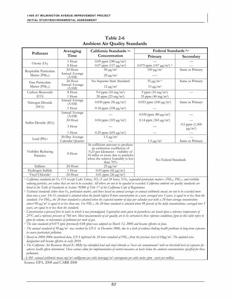
I-405 AT WILMINGTON AVENUE IMPROVEMENT PROJECT INITIAL STUDY/ENVIRONMENTAL ASSESSMENT
82
Table 2-6 Ambient Air Quality Standards
Federal Standards b,c Pollutant
Averaging Time
California Standards a,c Concentration Primary Secondary
1 Hour 0.09 ppm (180 µg/m3) — — Ozone (O3) 8 Hour 0.07 ppm (137 µg/m3) 0.075 ppm (147 µg/m3) d — 24 Hour 50 µg/m3 150 µg/m3 Same as Primary Respirable Particulate
Matter (PM10) Annual Average (AAM) 20 µg/m3 — e
24 Hour No Separate State Standard 35 µg/m3 f Same as Primary Fine Particulate Matter (PM2.5) Annual Average
(AAM) 12 µg/m3 15 µg/m3 8 Hour 9.0 ppm (10 mg/m3) 9 ppm (10 mg/m3) — Carbon Monoxide
(CO) 1 Hour 20 ppm (23 mg/m3) 35 ppm (40 mg/m3) Annual Average
(AAM) 0.030 ppm (56 µg/m3) 0.053 ppm (100 µg/m3) Same as Primary Nitrogen Dioxide (NO2) 1 Hour 0.18 ppm (338 µg/m3) —
Annual Average (AAM) — 0.030 ppm (80 µg/m3) —
24 Hour 0.04 ppm (105 µg/m3) 0.14 ppm (365 µg/m3) —
3 Hour — — 0.5 ppm (1,300 µg/m3)
Sulfur Dioxide (SO2)
1 Hour 0.25 ppm (655 µg/m3) — — 30-Day Average 1.5 µg/m3 — Lead (Pb) g Calendar Quarter — 1.5 µg/m3 Same as Primary
Visibility Reducing Particles 8 Hour
In sufficient amount to produce an extinction coefficient of
0.23 per kilometer - visibility of 10 miles or more due to particles when the relative humidity is less
than 70% Sulfates 24 Hour 25 µg/m3
Hydrogen Sulfide 1 Hour 0.03 ppm (42 µg/m3) Vinyl Chloridef 24 Hour 0.01 ppm (26 µg/m3)
No Federal Standards
a California standards for O3, CO (except Lake Tahoe), SO2 (1 and 24 hour), NO2, suspended particulate matter—PM10, PM2.5, and visibility reducing particles, are values that are not to be exceeded. All others are not to be equaled or exceeded. California ambient air quality standards are listed in the Table of Standards in Section 70200 of Title 17 of the California Code of Regulations.
b National standards (other than O3, particulate matter, and those based on annual averages or annual arithmetic mean) are not to be exceeded more than once a year. The O3 standard is attained when the fourth highest 8-hour concentration in a year, averaged over 3 years, is equal to or less than the standard. For PM10, the 24-hour standard is attained when the expected number of days per calendar year with a 24-hour average concentration above150 µg/m3 is equal to or less than one. For PM2.5, the 24-hour standard is attained when 98 percent of the daily concentrations, averaged over 3 years, are equal to or less than the standard.
c Concentration expressed first in units in which it was promulgated. Equivalent units given in parentheses are based upon a reference temperature of 25°C and a reference pressure of 760 torr. Most measurements of air quality are to be corrected to these reference conditions; ppm in this table refers to ppm by volume, or micromoles of pollutant per mole of gas.
d The new standard of 0.075 ppm (previously 0.08 ppm) was adopted on March 12, 2008 and became effective in June. e The annual standard of 50 μg/m3 was revoked by EPA in December 2006, due to a lack of evidence linking health problems to long-term exposure
to coarse particulate pollution. f Based on 2004-2006 monitored data, EPA tightened the 24-hour standard of PM2.5 from the previous level of 65μg/m3. The updated area
designation will become effective in early 2010. g The California Air Resources Board (CARB) has identified lead and vinyl chloride as 'toxic air contaminants' with no threshold level of exposure for
adverse health effects determined. These actions allow for implementation of control measures at levels below the ambient concentrations specified for these pollutants.
AAM –annual arithmetic mean; mg/m3–milligrams per cubic meter;μg/m3–micrograms per cubic meter; ppm - parts per million Source: EPA, 2008 and CARB 2008
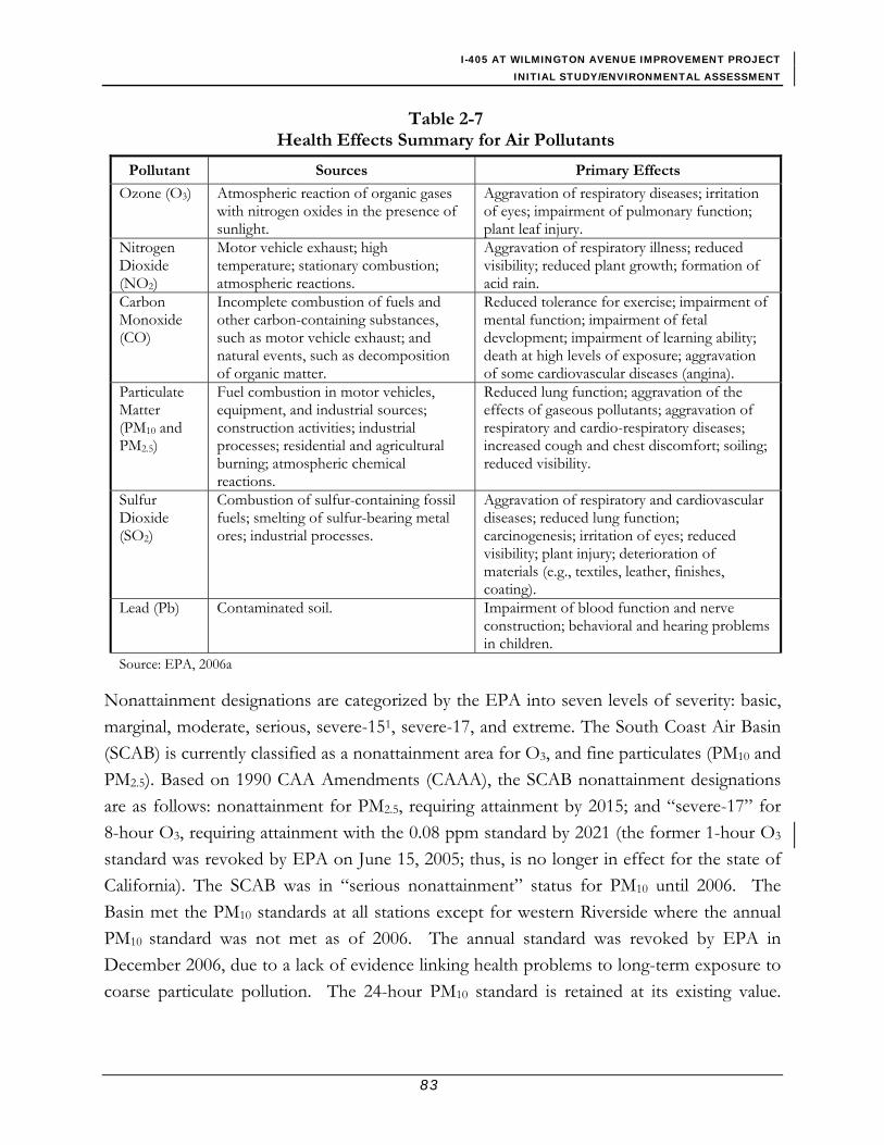
I-405 AT WILMINGTON AVENUE IMPROVEMENT PROJECT INITIAL STUDY/ENVIRONMENTAL ASSESSMENT
83
Table 2-7 Health Effects Summary for Air Pollutants
Pollutant Sources Primary Effects
Ozone (O3) Atmospheric reaction of organic gases with nitrogen oxides in the presence of sunlight.
Aggravation of respiratory diseases; irritation of eyes; impairment of pulmonary function; plant leaf injury.
Nitrogen Dioxide (NO2)
Motor vehicle exhaust; high temperature; stationary combustion; atmospheric reactions.
Aggravation of respiratory illness; reduced visibility; reduced plant growth; formation of acid rain.
Carbon Monoxide (CO)
Incomplete combustion of fuels and other carbon-containing substances, such as motor vehicle exhaust; and natural events, such as decomposition of organic matter.
Reduced tolerance for exercise; impairment of mental function; impairment of fetal development; impairment of learning ability; death at high levels of exposure; aggravation of some cardiovascular diseases (angina).
Particulate Matter (PM10 and PM2.5)
Fuel combustion in motor vehicles, equipment, and industrial sources; construction activities; industrial processes; residential and agricultural burning; atmospheric chemical reactions.
Reduced lung function; aggravation of the effects of gaseous pollutants; aggravation of respiratory and cardio-respiratory diseases; increased cough and chest discomfort; soiling; reduced visibility.
Sulfur Dioxide (SO2)
Combustion of sulfur-containing fossil fuels; smelting of sulfur-bearing metal ores; industrial processes.
Aggravation of respiratory and cardiovascular diseases; reduced lung function; carcinogenesis; irritation of eyes; reduced visibility; plant injury; deterioration of materials (e.g., textiles, leather, finishes, coating).
Lead (Pb) Contaminated soil. Impairment of blood function and nerve construction; behavioral and hearing problems in children.
Source: EPA, 2006a
Nonattainment designations are categorized by the EPA into seven levels of severity: basic, marginal, moderate, serious, severe-151, severe-17, and extreme. The South Coast Air Basin (SCAB) is currently classified as a nonattainment area for O3, and fine particulates (PM10 and PM2.5). Based on 1990 CAA Amendments (CAAA), the SCAB nonattainment designations are as follows: nonattainment for PM2.5, requiring attainment by 2015; and “severe-17” for 8-hour O3, requiring attainment with the 0.08 ppm standard by 2021 (the former 1-hour O3 standard was revoked by EPA on June 15, 2005; thus, is no longer in effect for the state of California). The SCAB was in “serious nonattainment” status for PM10 until 2006. The Basin met the PM10 standards at all stations except for western Riverside where the annual PM10 standard was not met as of 2006. The annual standard was revoked by EPA in December 2006, due to a lack of evidence linking health problems to long-term exposure to coarse particulate pollution. The 24-hour PM10 standard is retained at its existing value.

I-405 AT WILMINGTON AVENUE IMPROVEMENT PROJECT INITIAL STUDY/ENVIRONMENTAL ASSESSMENT
84
Currently, the Basin meets the 24-hour average federal standard and the only days that exceed the standard are associated with high wind natural events or exceptional events such as wildfires.
For CO, attainment demonstrations were previously submitted to EPA in 1992, 1994, and 1997 to bring the SCAB into attainment with the federal standard in 2000. In 2001, the CO standard was exceeded in the SCAB on three days, thus leaving the basin in nonattainment status. At that time, a request to EPA for an extension of the attainment date to 2002 was planned to be included in the revision to the 1997 Air Quality Management Plan (AQMP). Due to delays, the CO attainment demonstration provided in the 1997 AQMP amendments lapsed. In January 2005, the California Air Resources Board (CARB) declared CO attainment for the SCAB based on air quality data collected during 2001 through 2003. The redesignation has been approved by the State Office of Administrative Law, and it became effective on July 23, 2004. The 2005 CO Redesignation Request and Maintenance Plan for SCAB was reviewed and approved by EPA, and the federal CO attainment status for SCAB became effective on June 11, 2007.
All nonattainment areas are subject to a “transportation conformity” measure, requiring local transportation and air quality officials to coordinate their planning to ensure that transportation projects do not hinder an area’s ability to reach its clean air goals. These requirements become effective one year after an area’s nonattainment designation.
Request for reclassification of Basin’s 8-hour Ozone Status to Extreme Nonattainment For a nonattainment area, the CAA provides for voluntary reclassification of the area to a higher classification by submitting a request to the EPA. The SCAQMD has requested (as part of its 2007 Air Quality Management Plan submittal to EPA), a reclassification for the Basin from “sevre-17’ to “extreme” nonattainment. This would extend the 8-hour O3 attainment date to 2024 and allow for attainment demonstration to rely on emission reductions from measures that anticipate the development of new technologies or improving of existing control technologies.
State Regulations/Standards The State of California began to set California Ambient Air Quality Standards (CAAQS) in 1969 under the mandate of the Mulford-Carrell Act. The California Clean Air Act (CCAA) was enacted on September 30, 1988, and it became effective January 1, 1989. The CCAA requires all areas of the state to achieve and maintain the CAAQS by the earliest practicable 1 The “-15” and “-17” designate the number of years within which attainment must be achieved.

I-405 AT WILMINGTON AVENUE IMPROVEMENT PROJECT INITIAL STUDY/ENVIRONMENTAL ASSESSMENT
85
date. Table 2-6 shows the CAAQS currently in effect for each of the criteria pollutants, as well as the other pollutants recognized by the state. As shown in Table 2-6, the CAAQS are more stringent than the NAAQS for most of the criteria air pollutants. In general, the California state standards are more health protective than the corresponding NAAQS. In addition, the CAAQS include standards for other pollutants recognized by the state. For example, California has set standards for sulfates, hydrogen sulfide, vinyl chloride, and visibility-reducing particles. Moreover, on April 28, 2005, CARB approved a new 8-hour-average O3 standard of 0.070 ppm, to further protect California’s most vulnerable population (i.e., children) from the adverse health effects associated with ground-level O3. The standard went into effect early 2006.
Based on the CAAQS, the SCAB complies with the state standards for sulfates, hydrogen sulfide, and vinyl chloride, but is unclassified for the California standard for visibility-reducing particles.
Regional Air Quality Plan The CARB coordinates and oversees both state and federal air pollution control programs in California. The CARB has divided the state into 15 air basins. Authority for air quality control within each basin has been given to local Air Pollution Control Districts (APCD) or Air Quality Management Districts (AQMD) to regulate stationary source emissions and develop local plans for achieving and maintaining attainment.
The Southern California Air Quality Management District (SCAQMD) is the agency responsible for attaining state and federal clean air standards in the SCAB. Within Riverside County, the SCAQMD also has jurisdiction over the Salton Sea Air Basin and a portion of the Mojave Desert Air Basin. SCAQMD works directly with the Southern California Association of Governments (SCAG), county transportation commissions, and local governments; and it cooperates actively with all state and federal government agencies. SCAQMD regulates stationary source emissions and has been given the authority to regulate mobile emissions as an indirect source. As such, it also has transportation-related programs aimed primarily at reducing the number of cars on the road and promoting the use of cleaner fuels and vehicles. In addition, SCAQMD is responsible for developing and adopting an AQMP that serves as the blueprint for all future rules necessary to bring the SCAB into compliance with federal and state clean air standards. CARB regulates motor vehicles and fuels.
I-405 AT WILMINGTON AVENUE IMPROVEMENT PROJECT INITIAL STUDY/ENVIRONMENTAL ASSESSMENT
86
SCAQMD is required to update its plans on a regular basis. Updates may take the form of a new plan or an amendment. Plans range in scope from the regional AQMP to plans dealing with specific pollutants in specific geographic locales. Every three years, SCAQMD prepares an overall plan for air quality improvement. Each update of the plan includes revisions and amendments to the previous plan and has a 20-year horizon. The 2007 AQMP employs the most recent scientific findings, primarily in the form of updated emission inventories, ambient measurements, new meteorological episode data and new modeling tools. It also incorporates a comprehensive strategy aimed at controlling pollution from all sources, including stationary sources, area sources, on-road and off-road mobile sources.
The 2007 AQMP was adopted by the SCAQMD Governing Board on June 1, 2007. The 2007 AQMP Transportation Conformity Budgets was adopted by the Board on July 13, 2007 and was forwarded to CARB for its approval and subsequent submittal to EPA. Furthermore, on June 22, 2007, a State Strategy was proposed by the AQMD Board that recommended more aggressive actions to reduce emissions from mobile sources which contribute over 80 percent of the particulate matter pollution in the region. On September 27, 2007, the CARB adopted the revised State Strategy for the 2007 SIP and the 2007 AQMP as part of the SIP.
The Final 2007 AQMP builds upon improvements accomplished from previous plans, and aims to incorporate all feasible control measures while balancing costs and socioeconomic impacts. The 2007 AQMP outlines the air pollution control measures needed to meet federal health-based standards for O3 (8-hour standard) by 2024 and PM2.5 by 2015. The basic PM (PM10 and PM2.5) control strategy contained in the 1997 Plan and 2003 Plan, augmented by additional PM2.5 control measures included in this Plan revision (2007 AQMP), appears to be adequate to demonstrate attainment of the new federal PM2.5 standard. The emissions reductions are expected to be achieved through implementation of new and advanced control technologies as well as improvement of existing control techniques.
The 2007 AQMP includes a total of 31 stationary and 30 mobile source control measures. These measures are derived from:
• SCAQMD Stationary and Mobile Source Control Measures;
• State Control Strategy proposed by CARB; and
• SCAQMD Staff proposed Policy Options to supplement CARB’s Control Strategy;
• Transportation Strategy and Control Measures provided by SCAG.
I-405 AT WILMINGTON AVENUE IMPROVEMENT PROJECT INITIAL STUDY/ENVIRONMENTAL ASSESSMENT
87
AQMP control strategy for stationary and mobile source emissions are based on the following approaches:
• Energy efficiency and conservation;
• Equipment and facility modernization;
• Good management practices;
• Area source emission control programs;
• Market incentive/compliance flexibility; and
• Mobile source reduction programs.
SCAQMD adopts rules and regulations to implement portions of the AQMP. Several of these rules may apply to construction or operation of the project. For example, SCAQMD Rule 403 requires the implementation of best available fugitive dust control measures during active construction periods capable of generating fugitive dust emissions from onsite earth-moving activities, construction/demolition activities, and construction equipment travel on paved and unpaved roads.
Transportation Conformity Rule The CAA Amendments of 1990 require that transportation plans, programs, and projects that are funded by or approved under Title 23 U.S.C. or the Federal Transit Act, must conform to state or federal air quality plans for achieving the NAAQS. “Conformity” is defined under section 176(c) of the CAA as conforming to the purpose of the SIP to ensure that transportation plans, programs, and projects do not produce new air quality violations, worsen existing violations, or delay timely attainment of the NAAQS. According to the CAA, federally supported activities must conform to the implementation plan's purpose of attaining and maintaining these standards.
a. Regional Conformity Determination In determining whether a project conforms with an approved air quality plan, agencies must use current emission estimates based on the most recent population, employment, travel, and congestion estimates determined by an area’s metropolitan planning organization (MPO). MPOs are required to develop and maintain 20-year Regional Transportation Plans (RTP) and 3-year (at minimum) Regional Transportation Improvement Programs (RTIP or TIP) that set out transportation policies and programs for the region. A conforming RTIP/TIP model outcome projects that the regulated pollutants will be reduced to acceptable levels within time frames that meet the NAAQS.

I-405 AT WILMINGTON AVENUE IMPROVEMENT PROJECT INITIAL STUDY/ENVIRONMENTAL ASSESSMENT
88
SCAG is the Metropolitan Planning Organization (MPO) for the project region and is responsible for developing the RTP and RTIP for the region including Los Angeles, Orange, San Bernardino, Riverside, Imperial, and Ventura Counties. The RTP provides a long-term vision of regional transportation goals, policies, objectives, and strategies; assesses current and projected demand for travel and goods movement; and identifies necessary actions to meet the region’s mobility and accessibility needs. The 2008 RTP was federally approved on June 5, 2008.
SCAG developed the 2006 RTIP in compliance with state and federal requirements based on the list of projects proposed by the County transportation commissions. The 2006 RTIP implements the 2004 RTP, and includes a listing of all transportation projects proposed over a 6-year period, Fiscal Years (FY) 2006/7 – 2011/12. The 2006 RTIP was federally approved on October 2, 2006. It should be noted that the Final 2008 RTIP was adopted by SCAG on July17, 2008 and is pending state and federal approval.
b. Project Level Conformity Conformity at the project level requires hot-spot analysis for the projects in nonattainment or maintenance areas. As discussed previously, a region is a nonattainment area if one or more monitoring stations in the region fail to attain the relevant CAAQS or NAAQS. Areas that were previously designated as nonattainment, but have recently met the CAAQS or NAAQS, are called maintenance areas. In general, projects must not cause the CO standard to be violated, and in nonattainment areas, the project must not cause any increase in the number and severity of violations.
In March 2006, the Transportation Conformity Rule was updated to include regulations for performing qualitative analysis of PM10 and PM2.5 hot-spot impacts. Only projects that are considered “Projects of Air Quality Concern” are required to perform an analysis. Projects of air quality concern are defined, generally, as: 1) new or expanded highway projects that have a significant number of or significant increase in diesel vehicles, 2) projects affecting intersections that are Level of Service D, E, or F with a significant number of diesel vehicles, 3) new or expanded bus and rail terminals and transfer points with a significant number of diesel vehicles congregating in a single location, and 4) projects in or affecting locations, areas, or categories of sites that are identified in the PM10 or PM2.5 applicable implementation plan as sites of possible violation.
I-405 AT WILMINGTON AVENUE IMPROVEMENT PROJECT INITIAL STUDY/ENVIRONMENTAL ASSESSMENT
89
Pursuant to Federal Conformity Regulations [specifically, 40 CFR 93.105 (c)(l)(i)], a completed Interagency Review Form was prepared for the proposed project and was submitted to the SCAG’s Transportation Conformity Working Group (TCWG). The project Review Form was discussed among stakeholders at a TCWG meeting on May 22, 2007, to determine if the proposed project requires a project level PM hot-spot analysis. The TCWG determined that the project is not a project of air quality concern (POAQC). Therefore, no further PM hot-spot analysis is required to be included in this report. A copy of the Project Review Form, as well as the TCWG conformity determination is available upon request.
An Air Quality Conformity Analysis was performed for the proposed project for the project-level conformity determination for CO, PM10 and PM2.5. The conformity determination by FHWA is presented in Appendix J of this IS/EA document.
EPA Rule on Control of Mobile Source Air Toxics Mobile Source Air Toxics (MSATs) are a subset of the 188 air toxics defined in the CAA as hazardous air pollutants (HAPs). EPA identified 21 of these pollutants as MSATs, which are set forth in an EPA final rule, Control of Emissions of Hazardous Air Pollutants from Mobile Sources (66 CFR 17235). The list includes toxics that are emitted from both on-road mobile sources and non-road mobile sources, including non-road vehicles and construction equipment, commercial boats, trains, ships, and aircraft. EPA further extracted a subset of this list of 21 components that are now labeled as the “six priority MSATs.” These include benzene, formaldehyde, acetaldehyde, diesel particulate matter (DPM)/diesel exhaust organic gases, acrolein, and 1,3-butadiene, and they are considered the priority transportation toxics. Of these six pollutants, DPM, 1,3-Butadiene, and benzene account for approximately 89 percent of the total toxic air pollutants for potential excess cancer risk. DPM accounts for 71.2 percent of the total toxic air pollutants for potential excess cancer risk (FHWA, 2006; CARB, 2000).
The FHWA released interim guidance on February 3, 2006, to determine when and how to address MSAT impacts in the NEPA process for transportation projects. FHWA has identified three levels of analysis:
1) no analysis for exempt projects or projects with no potential for meaningful MSAT effects;
2) qualitative analysis for projects with low potential MSAT effects; and 3) quantitative analysis for projects with higher potential MSAT effects.

I-405 AT WILMINGTON AVENUE IMPROVEMENT PROJECT INITIAL STUDY/ENVIRONMENTAL ASSESSMENT
90
Under Category 1, three types of projects are included: a) projects qualifying as a categorical exclusion under 23 CFR 771.117(c); b) projects exempt under the CAA conformity rule under 40 CFR 93.126; and (c) other projects with no meaningful impacts on traffic volumes or vehicle mix. The proposed project would not affect traffic volume or mix in the project area; thus, it would have minimal potential MSAT effect.
The proposed project is not anticipated to affect traffic volume or mix in the project area; thus, based on the FHWA’s tiered approach in their interim guidance document, it would be considered to have minimal potential MSAT effect. Therefore, a qualitative assessment is provided to compare the potential effect of the project on traffic volumes, vehicle mix, or routing of traffic, and the associated changes in MSATs for the project alternatives, based on VMT, vehicle mix, and speed.
In addition to the criteria air pollutants for which there are National Ambient Air Quality Standards (NAAQS), EPA also regulates air toxics. Most air toxics originate from human-made sources, including on-road mobile sources, non-road mobile sources (e.g., airplanes), area sources (e.g., dry cleaners) and stationary sources (e.g., factories or refineries).
Mobile Source Air Toxics (MSATs) are a subset of the 188 air toxics defined by the Clean Air Act. The MSATs are compounds emitted from highway vehicles and non-road equipment. Some toxic compounds are present in fuel and are emitted to the air when the fuel evaporates or passes through the engine unburned. Other toxics are emitted from the incomplete combustion of fuels or as secondary combustion products. Metal air toxics also result from engine wear or from impurities in oil or gasoline.
The EPA is the lead Federal Agency for administering the Clean Air Act and has certain responsibilities regarding the health effects of MSATs. The EPA issued a Final Rule on Controlling Emissions of Hazardous Air Pollutants from Mobile Sources. 66 FR 17229 (March 29, 2001). This rule was issued under the authority in Section 202 of the Clean Air Act. In its rule, EPA examined the impacts of existing and newly promulgated mobile source control programs, including its reformulated gasoline (RFG) program, its national low emission vehicle (NLEV) standards, its Tier 2 motor vehicle emissions standards and gasoline sulfur control requirements, and its proposed heavy duty engine and vehicle standards and on-highway diesel fuel sulfur control requirements. Between 2000 and 2020, FHWA projects that even with a 64 percent increase in VMT, these programs will reduce

I-405 AT WILMINGTON AVENUE IMPROVEMENT PROJECT INITIAL STUDY/ENVIRONMENTAL ASSESSMENT
91
on-highway emissions of benzene, formaldehyde, 1,3-butadiene, and acetaldehyde by 57 percent to 65 percent, and will reduce on-highway diesel PM emissions by 87 percent.
California’s vehicle emission control and fuel standards are more stringent than Federal standards, and are effective sooner, so the effect on air toxics of combined State and Federal regulations is expected to result in greater emission reductions, more quickly, than the FHWA analysis shows. The FHWA analysis, with modifications related to use of the California-specific EMFAC model rather than the MOBILE model, would be conservative.
This IS/EA includes a basic analysis of the likely MSAT emission impacts of this project. However, available technical tools do not enable us to predict the project-specific health impacts of the emission changes associated with the alternatives in this IS/EA. Due to these limitations, the following discussion is included in accordance with CEQ regulations (40 CFR 1502.22(b)) regarding incomplete or unavailable information:
Information that is Unavailable or Incomplete
Evaluating the environmental and health impacts from MSATs on a proposed highway project would involve several key elements, including emissions modeling, dispersion modeling in order to estimate ambient concentrations resulting from the estimated emissions, exposure modeling in order to estimate human exposure to the estimated concentrations, and then final determination of health impacts based on the estimated exposure. Each of these steps is encumbered by technical shortcomings or uncertain science that prevents a more complete determination of the MSAT health impacts of this project.
• Emissions: The EPA and California tools to estimate MSAT emissions from motor vehicles are not sensitive to key variables determining emissions of MSATs in the context of highway projects. While both MOBILE 6.2 and EMFAC (either 2002 or the recently-released 2007 version) are used to predict emissions at a regional level, they have limitations when applied at the project level. Both are a trip-based models--emission factors are projected based on a typical trip of around 7.5 miles, and on average speeds for this typical trip. This means that neither model has the ability to predict emission factors for a specific vehicle operating condition at a specific location at a specific time. Because of this limitation, both models can only approximate emissions from the operating speeds and levels of congestion likely to be present on the largest-scale projects, and cannot adequately capture emissions effects of smaller projects. For particulate matter, the MOBILE 6.2 model results are not sensitive to average trip speed;
I-405 AT WILMINGTON AVENUE IMPROVEMENT PROJECT INITIAL STUDY/ENVIRONMENTAL ASSESSMENT
92
however, particulate matter (PM) emissions from the EMFAC model are sensitive to trip speed, so for California conditions diesel PM emissions are treated the same as other emissions. Unlike MOBILE 6.2, the EMFAC model does not provide MSAT emission factors; off-model speciation of EMFAC’s Total Organic Compounds output must be used to generate MSAT emissions. The emissions rates used in both MOBILE 6.2 and EMFAC are based on a limited number of vehicle tests.
These deficiencies compromise the capability of both MOBILE 6.2 and EMFAC 2002/2007 to estimate MSAT emissions. Both are adequate tools for projecting emissions trends, and performing relative analyses between alternatives for very large projects, but neither is sensitive enough to capture the effects of travel changes caused by smaller projects or to predict emissions near specific roadside locations.
• Dispersion. The tools to predict how MSATs disperse are also limited. The EPA's current regulatory models, CALINE3 and CAL3QHC, were developed and validated more than a decade ago for the purpose of predicting episodic concentrations of carbon monoxide (CO) to determine compliance with the NAAQS. The CALINE4 model used in California is an improvement on the CALINE3-based EPA models, but like them was built primarily for CO analysis, has not been specifically validated for use with other materials such as MSATs, and is difficult to use for averaging periods of more than 8 hours or so (health risk data for MSATs are typically based on 24-hr, annual, and long-term (30-70 years) exposure). Dispersion models are appropriate for predicting maximum concentrations that can occur at some time at some location within a geographic area, but cannot accurately predict exposure patterns at specific times at specific locations across an urban area to assess potential health risk. The NCHRP is conducting research on best practices in applying models and other technical methods in the analysis of MSATs. This work also will focus on identifying appropriate methods of documenting and communicating MSAT impacts in the NEPA process and to the general public. Along with these general limitations of dispersion models, FHWA is also faced with a lack of adequate monitoring data in most areas for use in establishing project-specific MSAT background concentrations.
• Exposure Levels and Health Effects. Finally, even if emission levels and concentrations of MSATs could be accurately predicted, shortcomings in current techniques for exposure assessment and risk analysis preclude us from reaching meaningful conclusions about project-specific health impacts. Exposure assessments are difficult because it is

I-405 AT WILMINGTON AVENUE IMPROVEMENT PROJECT INITIAL STUDY/ENVIRONMENTAL ASSESSMENT
93
difficult to accurately calculate annual concentrations of MSATs near roadways, and to determine the portion of a year that people are actually exposed to those concentrations at a specific location. These difficulties are magnified for 70-year cancer assessments, particularly because unsupportable assumptions would have to be made regarding changes in travel patterns and vehicle technology (which affects emissions rates) over a 70-year period. There are also considerable uncertainties associated with the existing estimates of toxicity of the various MSATs, because of factors such as low-dose extrapolation and translation of occupational exposure data to the general population. Because of these shortcomings, any calculated difference in health impacts between alternatives is likely to be much smaller than the uncertainties associated with calculating the impacts. Consequently, the results of such assessments would not be useful to decision makers, who would need to weigh this information against other project impacts that are better suited for quantitative analysis.
Summary of Existing Credible Scientific Evidence Relevant to Evaluating the Impacts of MSATs
Research into the health impacts of MSATs is ongoing. For different emission types, there are a variety of studies that show that some either are statistically associated with adverse health outcomes through epidemiological studies (frequently based on emissions levels found in occupational settings) or that animals demonstrate adverse health outcomes when exposed to large doses.
Exposure to toxics has been a focus of a number of EPA efforts. Most notably, the agency conducted the National Air Toxics Assessment (NATA) in 1996 to evaluate modeled estimates of human exposure applicable to the county level. While not intended for use as a measure of or benchmark for local exposure, the modeled estimates in the NATA database best illustrate the levels of various toxics when aggregated to a national or State level.
The EPA is in the process of assessing the risks of various kinds of exposures to these pollutants. The EPA Integrated Risk Information System (IRIS) is a database of human health effects that may result from exposure to various substances found in the environment. The IRIS database is located at http://www.epa.gov/iris. The following toxicity information for the six prioritized MSATs was taken from the IRIS database Weight of Evidence Characterization summaries. This information is taken verbatim from EPA's IRIS database and represents the Agency's most current evaluations of the potential hazards

I-405 AT WILMINGTON AVENUE IMPROVEMENT PROJECT INITIAL STUDY/ENVIRONMENTAL ASSESSMENT
94
and toxicology of these chemicals or mixtures. The five organic-based MSATs listed below are also listed as toxic air contaminants by the California Air Resources Board.
• Benzene is characterized as a known human carcinogen.
• The potential carcinogenicity of acrolein cannot be determined because the existing data are inadequate for an assessment of human carcinogenic potential for either the oral or inhalation route of exposure.
• Formaldehyde is a probable human carcinogen, based on limited evidence in humans, and sufficient evidence in animals.
• 1,3-butadiene is characterized as carcinogenic to humans by inhalation.
• Acetaldehyde is a probable human carcinogen based on increased incidence of nasal tumors in male and female rats and laryngeal tumors in male and female hamsters after inhalation exposure.
• Diesel exhaust (DE) is likely to be carcinogenic to humans by inhalation from environmental exposures. Diesel exhaust as reviewed in this document is the combination of diesel particulate matter and diesel exhaust organic gases. The particulate matter fraction of diesel exhaust (Diesel PM) has been identified by the California Air Resources Board as a toxic air contaminant due to long-term cancer risk.
• Diesel exhaust also is connected with chronic respiratory effects, possibly the primary noncancer hazard from MSATs. Prolonged exposures may impair pulmonary function and could produce symptoms, such as cough, phlegm, and chronic bronchitis. Exposure relationships have not been developed from these studies.
There have been other studies that address MSAT health impacts in proximity to roadways. The Health Effects Institute, a non-profit organization funded by EPA, FHWA, and industry, has undertaken a major series of studies to research near-roadway MSAT hot spots, the health implications of the entire mix of mobile source pollutants, and other topics. The final summary of the series is not expected for several years.
Some recent studies have reported that proximity to roadways is related to adverse health outcomes -- particularly respiratory problems. Much of this research is not specific to

I-405 AT WILMINGTON AVENUE IMPROVEMENT PROJECT INITIAL STUDY/ENVIRONMENTAL ASSESSMENT
95
MSATs, instead surveying the full spectrum of both criteria and other pollutants. The FHWA cannot evaluate the validity of these studies, but more importantly, they do not provide information that would be useful to alleviate the uncertainties listed above and enable us to perform a more comprehensive evaluation of the health impacts specific to this project.
Relevance of Unavailable or Incomplete Information to Evaluating Reasonably Foreseeable Significant Adverse Impacts on the Environment, and Evaluation of impacts based upon theoretical approaches or research methods generally accepted in the scientific community
Because of the uncertainties outlined above, a reliable quantitative assessment of the effects of air toxic emissions impacts on human health cannot be made at the project level. While available tools do allow us to reasonably predict relative emissions changes between alternatives for larger projects, the amount of MSAT emissions from each of the project alternatives and MSAT concentrations or exposures created by each of the project alternatives cannot be predicted with enough accuracy to be useful in estimating health impacts. (As noted above, the current emissions model is not capable of serving as a meaningful emissions analysis tool for smaller projects.) Therefore, the relevance of the unavailable or incomplete information is that it is not possible to make a determination of whether any of the alternatives would have "significant adverse impacts on the human environment."
In this document, FHWA has provided a qualitative analysis of MSAT emissions relative to the various alternatives, and has acknowledged that (some, all, or identify by alternative) the project alternatives may result in increased exposure to MSAT emissions in certain locations, although the concentrations and duration of exposures are uncertain, and because of this uncertainty, the health effects from these emissions cannot be estimated.
For each alternative in this IS/EA, the amount of MSATs emitted would be proportional to the vehicle miles traveled, or VMT, assuming that other variables such as fleet mix are the same for each alternative. The VMT estimated for each of the build alternatives is expected to be the same as that for the no-build alternative, because the proposed project is not expected to attract rerouted trips from elsewhere in the transportation network. According to the traffic study forecasts, based on unconstrained demand model (model used for isolated improvements projects) the traffic volume and mix would not be substantially be
I-405 AT WILMINGTON AVENUE IMPROVEMENT PROJECT INITIAL STUDY/ENVIRONMENTAL ASSESSMENT
96
affected by the project. The project improvements would only remove congestion at the intersections; it would not affect the traffic volumes. The main traffic distribution would be associated with the addition of the proposed new northbound on-ramp, which would remove the left turn at the southbound Wilmington Avenue and existing loop on-ramp intersection. As a result of project implementation, the average vehicle speed on Wilmington Avenue would improve. In the opening year (2010), the average peak hour speed will increase from 29 mph (No-Build) to 34 mph (AM) and 33 mph (PM) with the Build condition. And an increase of average peak hour speed from 27 mph for the No-Build condition to 33 mph (AM) and 31 mph (PM) in the horizon year, 2030.
Because the estimated VMT for the each of the build alternatives is expected to be nearly the same as the no-build alternative, it is expected there would be no appreciable difference in overall MSAT emissions among the various alternatives. Also, regardless of the alternative chosen, emissions will likely be lower than present levels in the design year as a result of EPA's and California’s control programs that are projected to reduce MSAT emissions by at least 57 to 87 percent between 2000 and 2020. Local conditions may differ from these national projections in terms of fleet mix and turnover, VMT growth rates, and local control measures. However, the magnitude of the EPA-projected reductions is so great (even after accounting for VMT growth) that MSAT emissions in the study area are likely to be lower in the future in nearly all cases.
The additional travel lanes contemplated as part of the project alternatives will have the effect of moving some traffic closer to nearby homes and businesses; therefore, under each alternative there may be localized areas where ambient concentrations of MSATs could be higher under certain build alternatives than the no-build alternative. The California Air Resources Board’s “Air Quality and Land Use Handbook” identifies the following land uses as particularly sensitive to MSATs: residential areas, schools, hospitals and other health care facilities, day care and other child care facilities, and parks and playgrounds. However, as discussed above, the magnitude and the duration of these potential increases compared to the no-build alternative cannot be accurately quantified due to the inherent deficiencies of current models. When a highway is widened and, as a result, moves closer to receptors, the localized effect of a given amount of MSAT emissions for the build alternative may be higher relative to the no-build alternative, but this should be offset due to increases in speeds and reductions in congestion (which are associated with lower MSAT emissions). Also, MSATs will be lower in other locations when traffic shifts away from them. However, on a regional basis, EPA's and California’s vehicle and fuel regulations, coupled with fleet

I-405 AT WILMINGTON AVENUE IMPROVEMENT PROJECT INITIAL STUDY/ENVIRONMENTAL ASSESSMENT
97
turnover, will over time cause substantial reductions that, in almost all cases, will cause region-wide MSAT levels to be significantly lower than today.
2.10.2 Affected Environment
Regional Setting The project site is located in Los Angeles County, an area within the South Coast Air Basin (Basin) that includes Orange County and the non-desert portions of Los Angeles, Riverside, and San Bernardino counties. Air quality conditions in the Basin are under the jurisdiction of the SCAQMD, a regional agency that regulates stationary sources of pollution throughout the Basin.
The Basin climate is determined by its terrain and geographical location. The Basin is a coastal plain with connecting broad valleys and low hills. The Pacific Ocean forms the southwestern border. High mountains surround the rest of the Basin.
The region lies in the semi-permanent, high-pressure zone of the eastern Pacific. The resulting climate is mild and tempered by cool ocean breezes. This climatological pattern is rarely interrupted. However, periods of extremely hot weather, winter storms, or Santa Ana wind conditions do exist.
The Basin experiences a persistent temperature inversion (increasing temperature with increasing altitude) as a result of the Pacific High. This inversion limits the vertical dispersion of air contaminants, holding them relatively near the ground. As the sun warms the ground and the lower air layer, the temperature of the lower air layer approaches the temperature of the base of the inversion (upper) layer until the inversion layer finally breaks, allowing vertical mixing with the lower layer. This phenomenon is observed in mid-afternoon to late afternoon on hot summer days, when the smog appears to clear up suddenly. Winter inversions frequently break by mid-morning.
Winds in the vicinity of the project area blow predominantly from the west-southwesterly direction, with relatively low velocities. Wind speeds in the project area average about 8 miles per hour (mph). Summer wind speeds average slightly higher than winter wind speeds. Low average wind speeds, together with a persistent temperature inversion, limit the vertical dispersion of air pollutants throughout the Basin. Strong, dry north or northeasterly winds, known as Santa Ana winds, occur during the fall and winter months, dispersing air contaminants. The Santa Ana conditions tend to last for several days at a time.

I-405 AT WILMINGTON AVENUE IMPROVEMENT PROJECT INITIAL STUDY/ENVIRONMENTAL ASSESSMENT
98
The combination of stagnant wind conditions and low inversions produces the greatest pollutant concentrations. On days of no inversion or high wind speeds, ambient air pollutant concentrations are lowest. During periods of low inversions and low wind speeds, air pollutants generated in urbanized areas are transported predominantly onshore into Riverside and San Bernardino counties. In the winter, the greatest pollution problems are CO and NOx because of extremely low inversions and air stagnation during the night and early morning hours. In the summer, the longer daylight hours and the brighter sunshine combine to cause a reaction between hydrocarbons and NOx to form photochemical smog.
Local Area Existing Air Quality Criteria Pollutants The proposed project site is located within SCAQMD jurisdiction. SCAQMD maintains a network of air quality monitoring stations located throughout the SCAB and has divided the Basin into 27 source/receptor areas (SRAs). The project is located in SRA number 4, South Coastal Los Angeles County. The nearest air monitoring station to the project site is the North Long Beach Monitoring Station (Station No. 072), which is located at 3648 Long Beach Boulevard, approximately 3 miles east of the eastern project limit. All criteria pollutants are monitored at this station (i.e., O3, CO, NO2, Pb, SO2, PM10, and PM2.5), as shown in Table 2-8. According to Table 2-8, exceedances of the California standards were recorded at the North Long Beach station for O3 (1-hour, California standard), PM10 (24-hour and annual), and PM2.5 (24-hour and annual) on one or more occasions from 2002 through 2005. The national standards were exceeded only for PM2.5 (24-hour and annual). No exceedances of either the state or national standards were recorded for SO2, Pb, NO2, or CO.

I-405 AT WILMINGTON AVENUE IMPROVEMENT PROJECT INITIAL STUDY/ENVIRONMENTAL ASSESSMENT
99
Table 2-8
Criteria Air Pollutants Data Summary (North Long Beach Monitoring Station)
Pollutant Standard 2003 2004 2005 2006 (1-Hour)
Maximum Concentration (ppm) 0.10 0.09 0.09 0.08 Days > CAAQS (0.09 ppm) 1 0 0 0
(8-Hour) Maximum Concentration (ppm) 0.07 0.07 0.07 0.06 Days > NAAQS (0.08 ppm) 0 0 0 0
Ozone (O3)
Days > CAAQS (0.07 ppm)a 0 0 0 0 (24-Hour)
Maximum Concentration (μg/m3) 63 72 66 51 Days > CAAQS (50 μg/m3) 24 25 24 n/a Days > NAAQS (150 μg/m3) 0 0 0 0
(Annual Average) National Annual Average (50 μg/m3)b 33 33 30 31
Particulate Matter (PM10)
State Annual Average (20 μg/m3)b 33 33 30 n/a (24-Hour)
Maximum Concentration (μg/m3) 115 67 54 59 Days > NAAQS (65 μg/m3) 3 c 1 0 0 3-year Average 98th Percentile (μg/m3)c 48 47 45 n/a
Particulate Matter (PM2.5)
(Annual) Annual Arithmetic Mean (15.0 μg/m3) 18.0 17.9 15.9 14.1
(1-Hour) Maximum Concentration (ppm) 5.5 4.2 4.2 4.2 Days > CAAQS (20 ppm) 0 0 0 0 Days > NAAQS (35 ppm) 0 0 0 0
(8-Hour) Maximum Concentration (ppm) 4.7 3.4 3.5 3.4
Carbon Monoxide (CO)
Days > CAAQS (9.0 ppm) 0 0 0 0 (1-hour)
Maximum Concentration (ppm) 0.14 0.12 0.14 0.10 Days > NAAQS (9 ppm) 0 0 0 0 Days > CAAQS (0.25 ppm) 0 0 0 0
Nitrogen Dioxide (NO2)
(Annual) Annual Arithmetic Mean (0.053 ppm) 0.029 0.028 0.024 0.024
(24-hour) Maximum Concentration (ppm) 0.008 0.012 0.010 0.010 Days > CAAQS (0.04 ppm) 0 0 0 0 Days > NAAQS (0.14 ppm) 0 0 0 0
Sulfur Dioxide (SO2)
(Annual) Annual Arithmetic Mean (0.03 ppm) 0.003 0.005 0.002 0.002
ppm – parts per million; μg/m3 – micrograms per cubic meter; AAM – Annual Arithmetic Mean; n/a – not available a The new California 8-hour-average O3 standard was adopted by CARB on April 28, 2005; therefore, the exceedance statistics are not
applicable before this date. b State statistics are based on California-approved samplers, whereas national statistics are based on samplers using federal reference or equivalent
methods. State and national statistics may therefore be based on different samplers. c Attainment condition for PM2.5 is that the 3-year average of the 98th percentile of 24-hour concentrations at each monitor within an
area must not exceed 65 μg/m3. Source: CARB, 2007.
I-405 AT WILMINGTON AVENUE IMPROVEMENT PROJECT INITIAL STUDY/ENVIRONMENTAL ASSESSMENT
100
Toxic Air Contaminants Toxic Air contaminants (TACs) consist of a variety of compounds, including metals, minerals, soot, and hydrocarbon-based chemicals. There are hundreds of different types of air toxics, with varying degrees of toxicity. Sources of TACs include industrial processes, such as petroleum refining and chrome plating operations; commercial operations, such as gasoline stations and dry cleaners; and motor vehicle exhaust. TACs are a concern in the SCAB because of the large number of mobile sources and industrial facilities throughout the basin.
The regulatory approach used in controlling TAC levels relies on a quantitative risk assessment process rather than on ambient air conditions to determine allowable levels of emissions from the source. In addition, for carcinogenic air pollutants, there is no safe concentration in the atmosphere. Local concentrations can pose a health risk and are termed “toxic hot spots.”
The regulatory approach used in controlling TAC levels relies on a quantitative risk assessment process rather than on ambient air conditions to determine allowable emissions from the source. In addition, for carcinogenic air pollutants, there is no safe concentration in the atmosphere. Local concentrations can pose a health risk and are termed “toxic hot spots.”
The most comprehensive study on air toxics in the SCAB is the Multiple Air Toxics Exposure Study (MATES-II), which was conducted by SCAQMD. The monitoring program measured more than 30 air toxics, including both gaseous and particulate TACs. The monitoring study was accompanied by a computer modeling study in which SCAQMD estimated the risk of cancer from breathing toxic air pollution throughout the region, based on emissions and weather data. MATES-II found that the maximum cancer risk in the region from carcinogenic air pollutants ranged from about 1,100 in a million to 1,750 in a million, with an average regional risk of approximately 1,400 in a million. The higher risk levels were found in the urban core areas in south central Los Angeles County, in Wilmington adjacent to the San Pedro Bay Ports, and near freeways. Overall, the study showed that airborne DPM contributed approximately 70 percent of the cancer risk. Mobile sources accounted for approximately 90 percent of the cancer risk, and industries and other stationary sources accounted for the remaining 10 percent.

I-405 AT WILMINGTON AVENUE IMPROVEMENT PROJECT INITIAL STUDY/ENVIRONMENTAL ASSESSMENT
101
The Air Resources Board (ARB) prepares a series of maps that show regional trends in estimated outdoor inhalable cancer risk from air toxic emissions in an ongoing effort to provide insight to the relative risk. The estimates represent the number of potential cancers per million people based on a lifetime of breathing air toxics (i.e., 24 hours per day outdoors for 70 years). The 2001 Southern Los Angeles County map, which is the most recently available map to represent existing conditions, shows the average cancer risk in this region ranges from 100 to 1,500 cases per million, while the vast majority of the project area is between 500 and 1,000 cancers per million.
Based on the finding that DPM is a significant contributor to cancer risk in the region, SCAQMD has approved fleet rules to limit diesel exhaust emitted by municipal vehicle fleets, trash trucks, street sweepers, taxis, shuttles, and buses in the region. That rule will be one of many measures outlined in a comprehensive plan to reduce toxic air pollution from both mobile and stationary sources. Other programs to reduce diesel emissions include SCAQMD grant programs that cover conversion of diesel equipment to alternative fuels.
Assembly Bill (AB) 1807 (Tanner Bill) set up a statewide process to determine the need for methods to set standards for TACs. The process includes identification of TACs, determination of emissions and ambient levels of the identified compounds, preparation of regulatory needs documents, and establishment of minimum statewide emission control standards by CARB.
Asbestos According to the California Division of Mines and Geology, the project location is not an area of naturally occurring asbestos. Naturally occurring asbestos areas are identified based on the type of rock found in the area. Asbestos containing rocks found in California are ultramafic rocks including serpentine rocks, which are not present in the project area (California Division of Mines and Geology, 2003).
Sensitive Receptors Residential areas are considered to be sensitive to air pollution because residents, including children and the elderly, tend to be at home for extended periods of time, resulting in sustained exposure to pollutants. Sensitive land uses in the project vicinity include one- and two-story detached residences that are located northwest of I-405 / Wilmington Avenue interchange. The closest residences are located approximately 65 feet from the I-405 NB shoulder. Other potentially sensitive uses in the more distant area include schools, religious institutions, and hospitals. The closest schools to the project site are the Carnegie Middle

I-405 AT WILMINGTON AVENUE IMPROVEMENT PROJECT INITIAL STUDY/ENVIRONMENTAL ASSESSMENT
102
School and Bonita Elementary School, which are located approximately 0.7-mile and 0.75-mile to the west of the project west limit, respectively. Nearest hospital is the Carson Artificial Kidney Center, which is located approximately 0.5-mile north of I-405. Several churches exist within 1-mile distance from I-405/Wilmington Avenue interchange.
2.10.3 Environmental Consequences This section describes the impacts of air pollutant emissions from project construction and operation on regional and local air quality.
Build Alternatives Temporary air quality impacts would result from project construction activities. Air pollutants would be emitted by construction equipment, and fugitive dust would be generated during construction activities, such as pavement grinding and paving operations. Once construction is completed, the primary source of regional emissions generated by the proposed project will be from motor vehicles.
Construction Impacts Project construction would be divided into 3 stages, as described in Section 2.5 of this report. Equipment operations and various construction activities would result in criteria air pollutant emissions on a temporary basis. The worst-case day construction emissions (i.e., the days that have the most intense construction activities) are calculated as summarized in Table 2-9. As shown in the table, with mitigation incorporated, construction of the project would emit the criteria air pollutants at the level less than the regional significance threshold levels set forth by the SCAQMD.
Table 2-9 Estimate of Project Daily Construction Emissions a (pounds/day)
Unmitigated Emissions Mitigated Emissions Construction Stage
VOC NOX CO PM10 VOC NOX CO PM10
STAGE 1
Phase 1 (3 months)
Onsite 5 60 23 5 b 4 57 22 4 Offsite c 1 18 8 <1 1 17 8 <1
Total 6 79 31 6 6 75 30 5 SCAQMD Regional Daily
Significance Threshold 75 100 550 150 75 100 550 150
Over/(Under) regional threshold (69) (21) (519) (144) (69) (25) (520) (145) Exceed Threshold? No No No No No No No No

I-405 AT WILMINGTON AVENUE IMPROVEMENT PROJECT INITIAL STUDY/ENVIRONMENTAL ASSESSMENT
103
Table 2-9 Estimate of Project Daily Construction Emissions a (pounds/day)
Unmitigated Emissions Mitigated Emissions Construction Stage
VOC NOX CO PM10 VOC NOX CO PM10
Maximum Construction Onsite Emissions d Maximum Daily (worst case days) 5 60 23 5 b — 57 22 4 h Localized Daily Significance Threshold — 125 417 4 — 125 417 4
Over/(Under) — (65) (394) 1 — (68) (395) 0 Exceed Threshold? — No No Yes — No No No
Phase 2 (3 months)
Onsite 5 60 23 8 b 4 57 22 6 Offsite c 1 18 8 <1 1 17 8 <1 Total 6 79 31 9 6 75 30 7 Over/(Under) regional threshold (69) (21) (519) (141) (69) (21) (520) (143) Exceed Threshold? No No No No No No No No Maximum Construction Onsite Emissions e Maximum Daily (worst case days) 5 60 23 8 b 4 57 22 6 Localized Daily Significance Threshold — 129 681 12 — 129 681 12
Over/(Under) — (69) (658) (4) — (72) (659) (6) Exceed Threshold? — No No No — No No No
Phase 3 (7 months)
Onsite 6 80 33 17 b 6 76 31 12 Offsite c 1 18 11 <1 1 18 10 <1 Total 8 99 44 18 8 94 42 13 Over/(Under) regional threshold (67) (1) (506) (132) (67) (6) (508) (137) Exceed Threshold? No No No No No No No No
Maximum Construction Onsite Emissions f Maximum Daily (worst case days) 6 80 33 17 b 6 76 31 12
Localized Daily Significance Threshold — 234 1,480 108 — 234 1,480 108
Over/(Under) — (154) (1,447) (91) — (158) (1,449) (96)
Exceed Threshold? — No No No — No No No
STAGE 2 Onsite 5 67 28 9b 5 63 26 7 Offsite c 1 16 9 <1 1 15 8 <1 Total 7 83 37 10 7 79 35 8 Regional Daily Significance
Threshold 75 100 550 150 75 100 550 150

I-405 AT WILMINGTON AVENUE IMPROVEMENT PROJECT INITIAL STUDY/ENVIRONMENTAL ASSESSMENT
104
Table 2-9 Estimate of Project Daily Construction Emissions a (pounds/day)
Unmitigated Emissions Mitigated Emissions Construction Stage
VOC NOX CO PM10 VOC NOX CO PM10
Over/(Under) (68) (17) (513) (140) (68) (21) (515) (142) Exceed Threshold? No No No No No No No No Maximum Construction Onsite Emissions g Maximum Daily (worst case days) 5 67 28 9 b 5 63 26 7
Localized Daily Significance Threshold
— 139 726 14 — 139 726 14
Over/(Under) — (72) (698) (5) — (76) (700) (7) Exceed Threshold? — No No No — No No No a Compiled using the CEQA Air Quality Handbook and the emissions inventory from OFFROAD model. The equipment mix and use
assumption for each phase is provided by the construction engineer, a list of which is included in the appendix to this technical assessment. b PM10 emissions estimates are based on compliance with SCAQMD Rule 403 requirements for fugitive dust suppression. c Offsite emissions include motor vehicle emissions associated with construction equipment transport to site, workers commute, and debris
hauling activities . d The project site is located in SCAQMD Source Receptor Area (SRA) No. 4. The nearest residences are located approximately 45 feet
north of the new onramp. In regard to the LST look-up tables, this analysis considered a maximum 0.5- acre would actively be disturbed at one time during Stage 1, Phase 1. The LSTs are for a 1-acre site with receptor within a 25- meter distance in SRA # 4
c The localized emission analysis for Stage 1, Phase 2 considered a maximum 1-acre per day would be disturbed; and LSTs are for a 1-acre site with receptor within a 50- meter distance in SRA No. 4
f The localized emission analysis for Stage 1, Phase 3 considered a maximum 2.6-acre per day would be disturbed; and LSTs are for a 2-acre site with receptor within a 100- meter distance in SRA No. 4 .
g The localized emission analysis for Stage 2 considered a maximum 1.2-acre would actively be disturbed at one time during Stage 2. The LSTs are for a 1-acre site with receptor within a 45- meter distance in SRA No. 4.
h Mitigation measure consists of maintaining construction equipment properly tuned. Exhaust emissions reduction is 5 percent for all criteria pollutants. Additional watering would provide 67 percent reduction in fugitive PM10 emissions.
Source: Parsons, 2007b.
The localized effects from onsite construction emissions were evaluated to determine potential pollutant concentrations at sensitive receptor locations. Localized construction emissions were estimated using the onsite mass daily emissions, considering a maximum disturbed area of 0.5 and 1 acres per day for construction stages 1 and 2, respectively. The first row of single-family residences north of I-405 and west of Wilmington Avenue were considered the closest sensitive receptors to the various construction sites as part of the air quality analysis. As shown in the Table 2-9, with mitigation measures incorporated, project construction would not cause exceedance of local daily emission thresholds for criteria air pollutants established by the SCAQMD (Parsons, 2007b).

I-405 AT WILMINGTON AVENUE IMPROVEMENT PROJECT INITIAL STUDY/ENVIRONMENTAL ASSESSMENT
105
Operational Impacts Based on the air quality analysis, project operations would not cause an exceedance of regional or local daily emission thresholds of criteria pollutants, as set forth by SCAQMD, EPA, and applicable state requirements as summarized in the following paragraphs.
A. Regional Impact Regional Air Quality Conformity The proposed project is fully funded and is in the SCAG 2008 RTP: Making the Connections which was found to conform by the SCAG on May 8, 2008, and FHWA and FTA adopted the air quality conformity finding on June 5, 2008. The proposed project is included in the Project Listing Report of the federally approved 2008 RTP, within the “Los Angeles County RTIP Projects” on page 23. The project is also included in SCAG’s financially constrained 2006 Regional Transportation Improvement Program (RTIP). The project is listed in the Final 2006 RTIP – Los Angeles County Local Highway Projects list, page 5, with the following description:
LAE0688 Model No.: L406; Program Code: CARH3; Description: Widen Wilmington Avenue from 223rd Street including I-405 ramp modification. Improve Wilmington Avenue/ I-405 interchange by adding a new northbound on-ramp and widening of Wilmington.
The SCAG 2006 RTIP was found to conform by FHWA and FTA on October 2, 2006. The project is also included in the 2008 RTIP Project Listing. The 2008 RTIP was adopted by SCAG on July 17, 2008 and is pending State and federal approvals. The design concept and scope of the proposed project is consistent with the project description in the 2008 RTP, the 2006 RTIP, and the assumptions in the SCAG’s regional emissions analysis. As such, project development would not conflict with or obstruct implementation of the Air Quality Management Plan (AQMP) or Transportation Control Measures (TCMs) identified in the currently approved SIP. No significant impact would occur and no mitigation measure would be required.
Regional Emissions Analysis The primary source of air pollutant emissions generated by the proposed project would be from motor vehicles traveling on Wilmington Avenue and freeway ramps within the project limits. To determine the regional direct operational impact, the emissions analysis was performed for the project study area including Wilmington Avenue and freeway ramps within the project limits. Criteria pollutant emissions from vehicles traveling in the project

I-405 AT WILMINGTON AVENUE IMPROVEMENT PROJECT INITIAL STUDY/ENVIRONMENTAL ASSESSMENT
106
study area were estimated and compared with the No Build Alternative for the opening year (2011) and design year (2030) using projected peak-hour vehicle miles traveled (VMT) data for the No Build and Build Alternatives, for respective roadway segments. As shown in Table 2-10, emissions of criteria pollutants under the Build Alternatives are estimated to be slightly lower than those from the No Build Alternative. This is due to the fact that similar VMTs for both the Build and No Build Alternatives, but slightly higher vehicle operating speeds for the project Build Alternative compared to the No Build Alternative. The Build Alternatives have a net beneficial effect on operational air quality.
Table 2-10 Summary of Operation Phase Regional Emissions (lbs/day)
Year Alternative Exhaust
CO Exhaust
VOC Exhaust
NOx Exhaust
SO2 PM10 Total
PM2.5 Total
2006 Existing 172.0 7.6 37.2 <1 1.7 1.1 No Build 123.3 4.9 26.2 <1 1.7 1.1 Build 118.5 4.5 25.9 <1 1.6 1.0 2011 Net Difference -4.8 -0.4 -0.3 0 -0.1 -0.1 No Build 40.9 1.4 7.1 <1 1.8 1.1 Build 39.1 1.3 7.0 <1 1.7 1.0 2030 Net Difference -0.8 -0.1 -0.1 0 -0.1 -0.1
1. Emissions are calculated using emission factors from EMFAC2002, at the projected average speed of each category of vehicles within the study area (from Traffic Study).
2. VMT and average speed data are summarized in Table 4-9 of this Air Quality Report. 3. The calculation worksheets are included in Appendix A to this report. Source: Parsons, 2007b.
B. Local Impacts
Project Level Conformity As previously described (see Section 2.10-1), the project area is designated as attainment/maintenance for federal CO standard, and nonattainment for federal and state ozone and particulate matters (PM10 and PM2.5); therefore, local hot-spot analyses have been performed for CO, PM10, and PM2.5 to determine the level of impact as a result of project operation. The analysis years consist of the project opening year (2011) and the design or horizon year (2030). B.1 CO Hot-Spot Analysis As part of the air quality analysis performed for this project (Parsons, 2007b), a screening exercise following the CO Hot-Spot Analysis Protocol (UC Davis, 1997) was performed to determine whether the project requires a qualitative or quantitative analysis or none would

I-405 AT WILMINGTON AVENUE IMPROVEMENT PROJECT INITIAL STUDY/ENVIRONMENTAL ASSESSMENT
107
be necessary. Based on the procedural analysis, it is concluded that the project is satisfactory and no qualitative CO analysis is required. Therefore, no impact from CO hot-spot is anticipated.
B.2 Particulate Matter (PM2.5 and PM10) Qualitative Hot-Spot Analysis A qualitative analysis for localized PM emissions was conducted following the methodology provided in EPA Guidelines.
The 2006 Final Transportation Conformity Rule defines a project of air quality concern (POAQC) that requires PM10 and PM2.5 hot-spot analysis in 40 CFR 93.123(b)(1) as:
1. New or expanded highway projects that have a significant number of or significant increase in diesel vehicles;
2. Projects affecting intersections that are at LOS D, E, or F with a significant number of diesel vehicles, or those that will change to LOS D, E, or F because of increased traffic volumes from a significant number of diesel vehicles related to the project;
3. New bus and rail terminals and transfer points that have a significant number of diesel vehicles congregating at a single location;
4. Expanded bus and rail terminals and transfer points that significantly increase the number of diesel vehicles congregating at a single location; and
5. Projects in or affecting locations, areas, or categories of sites that are identified in the PM2.5 and PM10 applicable implementation plan or implementation plan submission, as appropriate, as sites of violation or possible violation.
Pursuant to Federal Conformity Regulations [specifically, 40 CFR 93.105 (c)(l)(i)], a completed Interagency Review Form was prepared for the proposed project and was submitted to the SCAG’s Transportation Conformity Working Group (TCWG). The project Review Form was discussed among stakeholders at a TCWG meeting on May 22, 2007, to determine if the proposed project requires a project level PM hot-spot analysis. The TCWG determined that the project is not a project of air quality concern (POAQC). Therefore, no further PM hot-spot analysis is required to be included in this report. A copy of the Project Review Form, as well as the TCWG conformity determination is available upon request.
The proposed project is not considered a POAQC based on the following reasons:

I-405 AT WILMINGTON AVENUE IMPROVEMENT PROJECT INITIAL STUDY/ENVIRONMENTAL ASSESSMENT
108
• The proposed project is not a new or expanded highway project. It would not affect highway traffic volume or traffic mix. The new NB on-ramp would improve traffic conditions by eliminating the left turn queue of SB Wilmington to NB I-405 loop on-ramp, and redirecting the associated traffic to a right turn. The proposed project improvements include roadway widening and interchange improvements, but would not increase traffic on the surrounding roadways/highways. This type of project improves roadway operations by reducing traffic congestion and reducing delay time per vehicle. Based on the Traffic Study (Parsons, 2007), the proposed project would not increase traffic volumes along the local roadways. The traffic volume along the proposed segment of Wilmington Avenue would be well below the 125,000 average daily trips (ADT) threshold for a POAQC. Similarly, based on the project traffic study, even recognizing that the 10 percent truck traffic, truck volumes would be below the 10,000 truck ADT threshold for a POAQC.
• The proposed project would not affect intersections that are at LOS D, E, or F with a significant number of diesel vehicles. The purpose of the proposed project is to improve existing conditions by reducing the congestion and delay time per vehicle and/or improving the LOS at intersections within the project vicinity (see Section 4.3 (15) – Transportation and Traffic).
• The proposed project does not include the construction of a new bus or rail terminal.
• The proposed project does not expand an existing bus or rail terminal.
Therefore, the proposed project meets the CAA requirements and 40 CFR 93.116 without a qualitative hot-spot analysis pursuant to FHWA and EPA Transportation Conformity Guidance for Qualitative Hot-spot Analyses in PM2.5 and PM10 Nonattainment and Maintenance Areas. The proposed project would not create a new, or worsen an existing, PM10 or PM2.5 violation. A PM Conformity Hot-Spot Analysis form was prepared and was concurred in by the SCAG Transportation Conformity Working Group on May 22, 2007 (Parsons, 2007b).
Several projects were identified that are approved or planned within the project vicinity, as presented in Chapter 2 of this report. Since these projects are located within the locality of the proposed project, if construction of one or all of them occur at the same time, cumulative air quality impacts from construction emissions could temporarily result. Based on the proposed schedule of these projects, it is likely that they would be completed before the proposed project is constructed. The City of Carson will attempt to manage these
I-405 AT WILMINGTON AVENUE IMPROVEMENT PROJECT INITIAL STUDY/ENVIRONMENTAL ASSESSMENT
109
independent schedules to ensure that no two projects in the close vicinity would occur at the same time. This will minimize cumulative air quality impacts during construction.
Since these projects are listed in the 2006 RTIP and the 2004 RTP, they are consistent with the SIP and meet conformity requirements. Impacts from operation of these related projects are considered to be less than significant.
Sensitive land uses in the project vicinity include one- and two-story detached residences that are located northwest of I-405 / Wilmington Avenue interchange. The closest residences are located approximately 65 feet from the I-405 northbound shoulder. Other potentially sensitive uses in the more distant area include schools, religious institutions, and hospitals. The closest schools to the project site are the Carnegie Middle School and Bonita Elementary School, which are located approximately 0.7-mile and 0.75-mile west of the project western limit, respectively. The nearest hospital is the Carson Artificial Kidney Center, which is located approximately 0.5-mile north of I-405. Several churches exist within a 1-mile distance from I-405/Wilmington Avenue interchange.
As discussed previously, during construction, air quality significance thresholds would potentially be exceeded even with mitigation incorporated. This will result in short term potentially significant impacts to sensitive receptors during construction. However, air quality impacts would decrease in significance once the project becomes operational. This would result in a beneficial result for sensitive receptors.
The proposed project would improve traffic flow and safety conditions at the interchange. No objectionable odors are expected to be created as a result of implementing the proposed project. No impacts from odor would occur.
B.3 Mobile Source Air Toxics (MSATs). As previously discussed, technical shortcomings of emissions and dispersion models and uncertain science with respect to health effects prevent meaningful or reliable estimates of MSAT emissions and effects of this project. However, it is possible to qualitatively assess the levels of future MSAT emissions under the project build conditions. Furthermore, as described above, the UC Davis Project Level MSAT Analysis Spreadsheet Tool (UC Davis, 2006) can be used to provide a comparison of MSAT emissions for build and no-build project alternatives. However, for the proposed project, the difference between the traffic activities (e.g., VMTs, average speeds, percent trucks), would be minimal and thus, a qualitative comparison is provided. A qualitative analysis, although not appropriate to identify and

I-405 AT WILMINGTON AVENUE IMPROVEMENT PROJECT INITIAL STUDY/ENVIRONMENTAL ASSESSMENT
110
measure health impacts from MSATs, can give a basis for identifying and comparing the potential differences among MSAT emissions, if any, between the Build and No Build alternatives.
The amount of MSATs emitted would be proportional to the vehicle miles traveled, or VMT, assuming that other variables such as fleet mix are the same between the Build and No Build alternatives.
Based on the project traffic study, for all the local roadway segments, the estimated VMT for the No Build and the Build Alternative are similar. This is because the project is intended to alleviate the existing and future traffic congestions and delays; but not to increase traffic volumes. Nevertheless, the improved efficiency of the roadways could attract rerouted trips, although minimal, from elsewhere in the local transportation network. This increase in VMT would lead to slightly higher MSAT emissions for the Build alternative. The emissions increase is offset somewhat by lower MSAT emission rates due to increased vehicle speeds; since, according to EMFAC and MOBILE6 emissions models, emissions of all of the priority MSATs, except for diesel particulate matter, decrease as speed increases. The extent to which these speed-related emissions decreases will offset VMT-related emissions increases cannot be reliably projected due to the inherent deficiencies of technical models.
Furthermore, regardless of the alternative chosen, emissions will likely be lower than present levels in the design year as a result of EPA’s national control programs that are projected to reduce MSAT emissions by 57 to 87 percent from 2000 to 2020 (see Figure 4-1). Local conditions may differ from these national projections in terms of fleet mix and turnover, VMT growth rates, and local control measures. However, the magnitude of the EPA-projected reductions is so great (even after accounting for VMT growth) that MSAT emissions in the study area are likely to be lower in the future in virtually all locations.
Because the proposed project Alternative 2 includes a new connector on-ramp, there would be localized areas where VMT would increase, and other areas where VMT would decrease. Therefore it is possible that localized increases and decreases in MSAT emissions may occur. The localized increases in MSAT emissions would likely be most pronounced along the new northbound on-ramp. However, the traffic volume that would be redirected to this on-ramp would not be significant, and even if any increase in emissions occurs, they would be substantially reduced in the future due to implementation of EPA’s vehicle and fuel regulations.

I-405 AT WILMINGTON AVENUE IMPROVEMENT PROJECT INITIAL STUDY/ENVIRONMENTAL ASSESSMENT
111
In summary, under both Build Alternatives in the design year it is expected there would be reduced MSAT emissions in the immediate area of the project, relative to the No Build Alternative, due to the similar VMT, reduced congestion associated with direct routing, and the EPA’s MSAT reduction programs. In comparing the two project alternatives, MSAT levels could be higher in some locations than others, but the differences would not be substantial. Furthermore, on a regional basis, EPA’s vehicle and fuel regulations, coupled with fleet turnover, will over time cause substantial reductions that, in almost all cases, will cause region-wide MSAT levels to be significantly lower than today.
The EPA issued a Final Rule on Controlling Emissions of Hazardous Air Pollutants from Mobile Sources. 66 FR 17229 (March 29, 2001). While much work has been done to assess the overall health risk of air toxics, many questions remain unanswered. In particular, the tools and techniques for assessing project-specific health impacts from MSATs are limited. Furthermore, EPA has not established regulatory concentration targets for the six relevant MSAT pollutants appropriate for use in the project development process. However, FHWA has developed an interim guidance for analysis of potential impacts of mobile source toxics emissions to be included in NEPA documents (FHWA, 2006).
No-Build Alternative Under the No-Build Alternative, there would be no construction activities related to Wilmington Avenue capacity enhancement within the project limits. Therefore, no short-term pollutant emissions from construction equipment would occur. This alternative would retain the roadway with its existing lane configuration. Traffic demand would continue to increase, and congestion through the project limits would worsen.
2.10.4 Avoidance, Minimization, and Compensation Measures Reduction of construction emissions would be achieved by complying with the requirements of the existing SCAQMD rules and regulations, and implementing additional mitigation measures. Compliance with the SCAQMD rules and regulations as presented below is considered to be part of the project. Implementation of mitigation measures would be subject to mitigation monitoring.
Compliance with SCAQMD Rules • The project will be required to comply with regional rules, which would assist in
reducing short-term air pollutant emissions. The SCAQMD Rule 403 requires that fugitive dust be controlled with best available control measures so that the presence

I-405 AT WILMINGTON AVENUE IMPROVEMENT PROJECT INITIAL STUDY/ENVIRONMENTAL ASSESSMENT
112
of such dust does not remain visible in the atmosphere beyond the property line of the emission source. In addition, SCAQMD Rule 402 prohibits dust from creating a nuisance off site. Implementation of these dust suppression techniques, as required by the SCAQMD, can reduce fugitive dust generation (and thus the PM10 component) by 50 to 75 percent. Compliance with these rules would reduce impacts on nearby sensitive receptors.
• Compliance with SCAQMD Rule 1113 on the use of architectural coatings shall be implemented to reduce VOC emissions, as feasible.
Additional Mitigation Measures
• All land clearing/earth-moving activity areas shall be watered to remain visibly moist during active operations.
• Water, three times daily, or non-toxic soil stabilizers shall be applied, as needed, to reduce off-site transport of fugitive dust from all unpaved staging areas and unpaved road surfaces.
• Construction equipment shall be properly tuned and maintained in accordance with manufacturer’s specifications.
• During construction, trucks and vehicles in loading and unloading queues must be kept with their engines off when not in use to reduce vehicle emissions. Construction emissions shall be phased and scheduled to avoid emissions peaks, where feasible, and discontinued during second-stage smog alerts.
2.11 Noise A Noise Study Report was prepared to assess potential noise impacts of the proposed project on noise sensitive receptors located within the vicinity of the project site. The analysis followed the Caltrans Traffic Noise Analysis Protocol (Protocol) (Caltrans, 2006) and Technical Noise Supplement (Caltrans, 1998), which satisfy the requirements for noise compatibility studies and abatement requirements. The Protocol is also consistent with the requirements of FHWA and it is designed to evaluate potential traffic-generated noise impacts, as well as determining reasonable and feasible noise abatement measures for the project.
Alternative 2 was considered for the analysis because it includes the addition of a new NB on-ramp which would bring the roadway traffic closer to the sensitive receptors than

I-405 AT WILMINGTON AVENUE IMPROVEMENT PROJECT INITIAL STUDY/ENVIRONMENTAL ASSESSMENT
113
Alternative 1; therefore, it provides the “worst-case” scenario. Results of the noise impact analysis indicated that there would be traffic noise impact at the residences located west of I-405 between Wilmington Avenue and the Dominguez Channel. Soundwalls are recommended to provide noise abatement.
Information related to study methodology and detailed study results can be found in the Noise Study Report (Parsons, 2007f), which is incorporated by reference to this IS/EA with MND/FONSI document.
2.11.1 Regulatory Setting The NEPA and CEQA provide the broad basis for analyzing and abating highway traffic noise effects. The intent of these laws is to promote the general welfare and to foster a healthy environment. The requirements for noise analysis and consideration of noise abatement and/or mitigation, however, differ between NEPA and CEQA.
California Environmental Quality Act CEQA requires a strictly baseline versus build analysis to assess whether a proposed project will have a noise impact. If a proposed project is determined to have a significant noise impact under CEQA, then CEQA dictates that mitigation measures must be incorporated into the project unless such measures are not feasible.
National Environmental Policy Act and 23 CFR 772 For highway transportation projects with FHWA (and the Department, as assigned) involvement, the Federal-Aid Highway Act of 1970 and the associated implementing regulations (23 CFR 772) govern the analysis and abatement of traffic noise impacts. The regulations require that potential noise impacts in areas of frequent human use be identified during the planning and design of a highway project. The regulations contain noise abatement criteria (NAC) that are used to determine when a noise impact would occur. The NAC differ depending on the type of land use under analysis. For example, the NAC for residences (67 A-weighted decibel [dBA]) is lower than the NAC for commercial areas (72 dBA). Table 2-11 lists the noise abatement criteria for use in the NEPA-23 CFR 772 analysis.
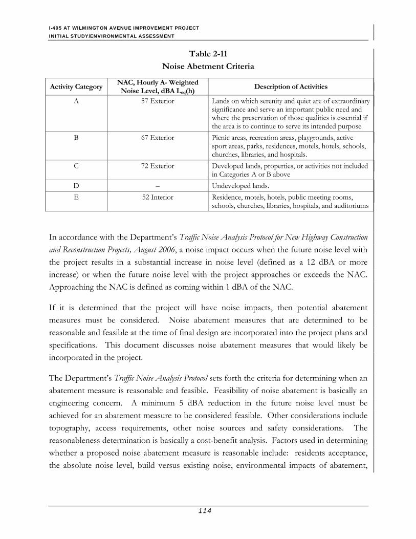
I-405 AT WILMINGTON AVENUE IMPROVEMENT PROJECT INITIAL STUDY/ENVIRONMENTAL ASSESSMENT
114
Table 2-11
Noise Abetment Criteria
Activity Category NAC, Hourly A- Weighted Noise Level, dBA Leq(h)
Description of Activities
A 57 Exterior Lands on which serenity and quiet are of extraordinary significance and serve an important public need and where the preservation of those qualities is essential if the area is to continue to serve its intended purpose
B 67 Exterior Picnic areas, recreation areas, playgrounds, active sport areas, parks, residences, motels, hotels, schools, churches, libraries, and hospitals.
C 72 Exterior Developed lands, properties, or activities not included in Categories A or B above
D – Undeveloped lands. E 52 Interior Residence, motels, hotels, public meeting rooms,
schools, churches, libraries, hospitals, and auditoriums
In accordance with the Department’s Traffic Noise Analysis Protocol for New Highway Construction and Reconstruction Projects, August 2006, a noise impact occurs when the future noise level with the project results in a substantial increase in noise level (defined as a 12 dBA or more increase) or when the future noise level with the project approaches or exceeds the NAC. Approaching the NAC is defined as coming within 1 dBA of the NAC.
If it is determined that the project will have noise impacts, then potential abatement measures must be considered. Noise abatement measures that are determined to be reasonable and feasible at the time of final design are incorporated into the project plans and specifications. This document discusses noise abatement measures that would likely be incorporated in the project.
The Department’s Traffic Noise Analysis Protocol sets forth the criteria for determining when an abatement measure is reasonable and feasible. Feasibility of noise abatement is basically an engineering concern. A minimum 5 dBA reduction in the future noise level must be achieved for an abatement measure to be considered feasible. Other considerations include topography, access requirements, other noise sources and safety considerations. The reasonableness determination is basically a cost-benefit analysis. Factors used in determining whether a proposed noise abatement measure is reasonable include: residents acceptance, the absolute noise level, build versus existing noise, environmental impacts of abatement,

I-405 AT WILMINGTON AVENUE IMPROVEMENT PROJECT INITIAL STUDY/ENVIRONMENTAL ASSESSMENT
115
public and local agencies input, newly constructed development versus development pre-dating 1978 and the cost per benefited residence.
2.11.2 Affected Environment
Fundamental of Traffic Noise Sound, Noise, and Acoustic Sound is mechanical energy transmitted by pressure waves in a compressible medium (i.e., gaseous, liquid, or the elastic stage of a solid). For traffic sound, the medium of concern is air. Noise is generally defined as unwanted sound that may be loud, unpleasant, unexpected, or undesired. Although sound can be easily measured, the perceptibility of sound is subjective, and the physical response to sound complicates the analysis of its impact on people. People judge the relative magnitude of sound in subjective terms such as “noisiness” or “loudness.”
Frequency and Hertz A continuous sound can be described by its frequency (pitch) and its amplitude (loudness). Low-frequency sounds are low in pitch, like the low notes on a piano keyboard; similarly, high-frequency or high-pitch notes can be generated by the high notes on a piano. Frequency relates to the pressure wave oscillations and is expressed in terms of rate of oscillations, or cycles, per second. Cycles per second are commonly referred to as Hertz (Hz). The human hearing system is not equally sensitive to sound at all frequencies. The range of frequencies that can be heard by the healthiest human ears spans from 16 to 20 Hz on the low end to approximately 20,000 Hz (or 20 kilohertz [kHz]) on the high end.
Sound Pressure Levels and Decibels The amplitude of a sound determines its loudness. Sound pressure amplitude is measured in units of micro-Newton per square meter (µN/m2), also called micro-Pascal (µPa). One µPa is approximately one hundred billionths (0.00000000001) of normal atmospheric pressure. Sound pressure level (Lp) is measured and quantified using a logarithmic ratio of actual sound pressures to a reference pressure squared. This unit is called decibel and abbreviated as dB.
A-Weighted Decibels Sound pressure level alone is not a reliable indicator of loudness. The frequency, or pitch, of a sound also has a substantial effect on how humans will respond. The human hearing system is not equally sensitive to sound at all frequencies; therefore, to approximate this frequency-dependent human response, the A-weighted system is used to adjust measured

I-405 AT WILMINGTON AVENUE IMPROVEMENT PROJECT INITIAL STUDY/ENVIRONMENTAL ASSESSMENT
116
sound levels. The A-weighted sound level is expressed as “dBA.” This scale de-emphasizes low frequencies to which human hearing is less sensitive and focuses on mid- to high-range frequencies. In general, the healthy human ear is most sensitive to sound frequencies between 1,000 Hz and 5,000 Hz, and it perceives a sound within that range as being more intense than a sound of higher or lower frequency with the same magnitude. The A-scale weighting approximates the frequency response of the average young ear when listening to most ordinary sounds. Noise levels for traffic noise studies are typically reported in terms of A-weighted decibels (dBA). In environmental noise studies, A-weighted sound pressure levels are commonly referred to as noise levels. Figure 2-10 shows typical A-weighted noise levels.
Figure 2-10 Typical A-Weighted Sound Levels Human Response to Changes in Noise Levels It is widely accepted that the smallest change in sound levels that is detectable by human hearing under ambient conditions is 3 to 5 decibels (dB). A change of 5 dB or greater is readily perceptible, and a change of 10 dB is perceived as being twice or half as loud. Changes of 1 to 3 dB are detectable only under quiet, controlled conditions; and changes of less than 1 dB are usually indiscernible.

I-405 AT WILMINGTON AVENUE IMPROVEMENT PROJECT INITIAL STUDY/ENVIRONMENTAL ASSESSMENT
117
As discussed previously, doubling of sound energy results in a 3-dB increase in the sound level, which means that doubling of sound energy (e.g., doubling the volume of traffic on a highway) would result in a barely perceptible change in sound level.
Noise levels from a particular source generally decline as distance to the receptor increases. Other factors, such as the weather and reflecting or shielding, also intensify or reduce the noise level at any given location.
Noise Descriptors Noise in our daily environment fluctuates over time. Some noise levels occur in regular patterns, others are random. Some noise levels fluctuate rapidly, others slowly. Some noise levels vary widely, others are relatively constant. Various noise descriptors have been developed to describe time-varying noise levels. The following is a list of the noise descriptors most commonly used in traffic noise analysis:
• Equivalent Sound Level (Leq) – Leq is a measurement of the acoustical energy content of sound averaged over a specified period; thus, the Leq of a time-varying noise and that of a steady noise are the same if they deliver the same amount of acoustical energy to the ear during exposure. The 1-hour A-weighted equivalent sound level, Leq(h), is the energy average of the A-weighted sound levels occurring during a 1-hour period and is the basis for NAC used by Caltrans and FHWA.
• Maximum Sound Level (Lmax) – Lmax is the highest instantaneous sound level measured during a specified period.
• Insertion Loss (I.L.) – I.L. is the actual noise-level reduction at a specific receiver because of construction of a noise barrier between the noise source (e.g., roadway traffic) and the receiver. Generally, it is the net effect of the soundwall attenuation and the loss due to ground-type effects.
Sound Propagation As sound propagates over a distance, it changes in both pressure level and frequency content. The manner in which noise reduces with distance depends on the following factors:
• Geometric Spreading – Sound from a small, localized source (i.e., a point source) radiates uniformly outward as it travels away from the source in a spherical pattern. The sound level attenuates (or drops off) at a rate of 6 dB for each doubling of distance. Highway noise is not a single, stationary point source of sound. The movement of the vehicles on a highway makes the source of the sound appear to emanate from a line (i.e.,
I-405 AT WILMINGTON AVENUE IMPROVEMENT PROJECT INITIAL STUDY/ENVIRONMENTAL ASSESSMENT
118
a line source) rather than a point. This line source results in cylindrical spreading rather than the spherical spreading which results from a point source. The change in sound level from a line source is 3 dB per doubling of distance.
• Ground Absorption – Most often, the noise path between the highway and the observer is very close to the ground. Noise attenuation from ground absorption and reflective wave canceling adds to the attenuation associated with geometric spreading. Traditionally, the excess attenuation has also been expressed in terms of attenuation per doubling of distance. For acoustically hard sites (i.e., those sites with a reflective surface, such as a parking lot or a smooth body of water, between the source and the receiver), no excess ground attenuation is assumed. For acoustically absorptive or soft sites (i.e., those sites with an absorptive ground surface, such as soft dirt, grass, or scattered bushes and trees, between the source and the receiver), an excess ground attenuation value of 1.5 dB per doubling of distance is normally assumed. When added to the geometric spreading, the excess ground attenuation results in an overall drop-off rate of 4.5 dB per doubling of distance for a line source and 7.5 dB per doubling of distance for a point source.
• Atmospheric Effects – Research by Caltrans and others has shown that atmospheric conditions can have a significant effect on noise levels when noise receptors are located more than 200 feet from a highway. Wind has been shown to be the most important meteorological factor within approximately 500 feet of the source, whereas vertical air temperature gradients are more important for greater distances. Other factors, such as air temperature, humidity, and turbulence, also have significant effects.
Existing Noise Environment The noise environment in the project area is dominated by traffic traveling along I-405 and Wilmington Avenue. Noise measurements were conducted in March 2007 at two representative sensitive receptor locations within the project limits to establish the baseline conditions and calibrate the roadway traffic noise prediction model. Land uses adjacent to the project corridor consist of single-family homes located along SB Wilmington Avenue, north of I-405 in the project area; the other properties along Wilmington Avenue are either commercial or industrial. Figure 2-11 shows the locations of sensitive receptors and measurement sites. Noise measurements indicate that the vehicular traffic noise associated with I-405 was the dominant noise source at these locations.

D o m i n g u e z
C h a n n e l
WILMING
TON
E. 223RD ST.
PARSONS
S A ND I E G O
F W Y.
405
E. 22OTH ST.
Figure 2-11
Sensitive Receptors and Noise Monitoring Locations
AVE.
NNO SCALE
S P R R
I-405 / WILMINGTON AVENUE INTERCHANGE IMPROVEMENT PROJECT
I-405 N/B Off Ramp
I-405 NORTHBOUNDI-405 SOUTHBOUND
OnN/B
I-405
Ramp
I-405 S/B On Ramp
I-405 S/B Off Ramp
R1
R2R3R4R5R6R7R8
R9
R10
LT1ST1
Representative Sensitive Receptors
Short-Term Noise Measurement Location
Long-Term Noise Measurement Location
R4
LEGEND

I-405 AT WILMINGTON AVENUE IMPROVEMENT PROJECT INITIAL STUDY/ENVIRONMENTAL ASSESSMENT
120
This page intentionally left blank.

I-405 AT WILMINGTON AVENUE IMPROVEMENT PROJECT INITIAL STUDY/ENVIRONMENTAL ASSESSMENT
121
The ambient noise level at one of the measurement sites (LT1) was continuously measured for a minimum of 24 hours. The noise level at the other site (ST1) was sampled for a short-term duration of 20 minutes. Table 2-12 presents the results of the short-term and long-term measurements. The measurement results indicate that existing traffic noise level for the residential area is 68 dBA-Leq(h).
Table 2-12
Noise Measurement Results
Site No.
Street Address,
City
Land Usea
Meter Location
Measurement Dates
Start Time
Measure-ment
Duration
Peak-Hour Time
Measured Peak-Hour Leq, dBAb
LT1 1600 Bach Street SFR Back
Yard March 5-6, 2007 12:10 PM 24 hours 1:00 PM 69.9
ST1 1526 Bach Street SFR Back
Yard March 5,
2007 12:56 PM 20 minutes 1:00 PM 67.7
a Land Use: SFR – single-family residence. b The measured peak-hour noise level recorded during the long-term measurement period. Source: Parsons, 2007f.
2.11.3 Environmental Consequences Federal and state regulations, standards, and policies relating to traffic noise are discussed in detail in the Caltrans Traffic Noise Analysis Protocol (Protocol), (Caltrans, 2006). Protocol requirements apply to Type 1 projects. A Type 1 project is defined in 23 CFR 772 as a proposed federal or federal-aid highway project for the construction of a highway on a new location or the physical alteration of an existing highway that significantly changes either the horizontal or vertical alignment or increases the number of through traffic lanes. The FHWA has clarified its interpretation of Type 1 projects by stating that a Type 1 project is any project that has the potential to increase noise levels at adjacent receptors. This includes projects to add interchanges, ramps, or auxiliary or truck-climbing lanes to an existing highway. A project to widen an existing ramp by a full lane width is also considered a Type 1 project. Caltrans extends this definition to include state-funded highway projects. The proposed project’s build alternative evaluated in this report is Alternative 2, and it is considered Type 1 because it includes an increase in the number of through traffic lanes, or constructing a new freeway or new alignment.
Build Alternatives
Construction Phase During construction of the project, noise from construction activities may intermittently dominate the noise environment in the immediate surrounding area. Construction noise is
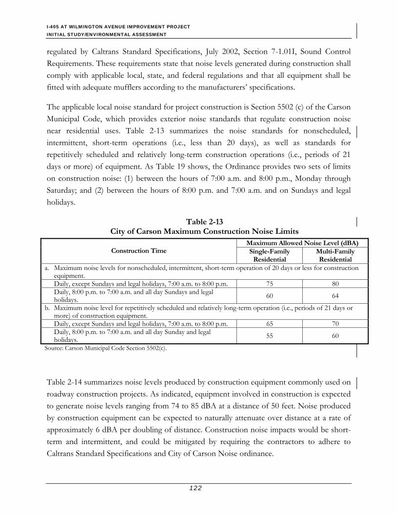
I-405 AT WILMINGTON AVENUE IMPROVEMENT PROJECT INITIAL STUDY/ENVIRONMENTAL ASSESSMENT
122
regulated by Caltrans Standard Specifications, July 2002, Section 7-1.01I, Sound Control Requirements. These requirements state that noise levels generated during construction shall comply with applicable local, state, and federal regulations and that all equipment shall be fitted with adequate mufflers according to the manufacturers’ specifications.
The applicable local noise standard for project construction is Section 5502 (c) of the Carson Municipal Code, which provides exterior noise standards that regulate construction noise near residential uses. Table 2-13 summarizes the noise standards for nonscheduled, intermittent, short-term operations (i.e., less than 20 days), as well as standards for repetitively scheduled and relatively long-term construction operations (i.e., periods of 21 days or more) of equipment. As Table 19 shows, the Ordinance provides two sets of limits on construction noise: (1) between the hours of 7:00 a.m. and 8:00 p.m., Monday through Saturday; and (2) between the hours of 8:00 p.m. and 7:00 a.m. and on Sundays and legal holidays.
Table 2-13 City of Carson Maximum Construction Noise Limits
Maximum Allowed Noise Level (dBA) Construction Time Single-Family
Residential Multi-Family Residential
a. Maximum noise levels for nonscheduled, intermittent, short-term operation of 20 days or less for construction equipment. Daily, except Sundays and legal holidays, 7:00 a.m. to 8:00 p.m. 75 80 Daily, 8:00 p.m. to 7:00 a.m. and all day Sundays and legal holidays. 60 64
b. Maximum noise level for repetitively scheduled and relatively long-term operation (i.e., periods of 21 days or more) of construction equipment. Daily, except Sundays and legal holidays, 7:00 a.m. to 8:00 p.m. 65 70 Daily, 8:00 p.m. to 7:00 a.m. and all day Sunday and legal holidays. 55 60
Source: Carson Municipal Code Section 5502(c).
Table 2-14 summarizes noise levels produced by construction equipment commonly used on roadway construction projects. As indicated, equipment involved in construction is expected to generate noise levels ranging from 74 to 85 dBA at a distance of 50 feet. Noise produced by construction equipment can be expected to naturally attenuate over distance at a rate of approximately 6 dBA per doubling of distance. Construction noise impacts would be short-term and intermittent, and could be mitigated by requiring the contractors to adhere to Caltrans Standard Specifications and City of Carson Noise ordinance.

I-405 AT WILMINGTON AVENUE IMPROVEMENT PROJECT INITIAL STUDY/ENVIRONMENTAL ASSESSMENT
123
Table 2-14 Construction Equipment Noise
Type of Equipment Maximum Noise Level,
dBA at 50 feet
Excavator 83 Backhoe 75
Front End Loader 74 Dozer 85 Grader 75
Concrete Pump 81 Vibratory Roller 78
Compactor 76 Crane 85
Asphalt Paver 79 Asphalt Roller 78
Heavy-Duty Dump Trucks 77 Source: Parsons, 2007f.
Operation Noise The land use within the project limits is comprised of residences, commercial, and industrial developments. FHWA regulations (23CFR772) and the Traffic Noise Analysis Protocol (TNAP) state that noise abatement is only considered where noise impacts are predicted and only where frequent human use occurs, and where a lowered noise level would be of benefit. As a matter of practice, abatement is only considered for places where people are exposed to highway noise for at least 1 hour on a regular basis. Potential noise abatement measures include:
• Avoiding the project impact by using design alternatives, such as altering the horizontal and vertical alignment of the project
• Constructing noise barriers (soundwalls)
• Acquiring property to serve as a buffer zone
• Using traffic management measures to regulate types of vehicles and speeds
• Acoustically insulating public use or nonprofit institutional structures.
Noise Modeling A noise assessment was conducted to determine future noise impacts of the proposed project at sensitive receptors within the boundaries of the project (Parsons, 2007f). The future/worst-case scenario traffic noise levels at the outdoor frequent human use areas along

I-405 AT WILMINGTON AVENUE IMPROVEMENT PROJECT INITIAL STUDY/ENVIRONMENTAL ASSESSMENT
124
the project corridor were modeled for Alternative 2 roadway and future traffic conditions to determine the appropriate abatement measures.
The FHWA traffic noise model, TNM 2.5, was used for the roadway noise computations (FHWA 2004). TNM 2.5 input is based on a three-dimensional grid created for the study area to be modeled. All roadway, barrier, and receiver points are defined by their x, y, and z coordinates. Roadways and barriers are coded into TNM 2.5 as line segments defined by their end points. Receivers, defined as single points, are typically located at sensitive receptors, such as residences, schools, and recreational outdoor areas. Receivers are modeled at a height of 5 feet above ground elevation.
To determine the noise levels generated by roadway traffic, the TNM 2.5 computer program requires inputs of traffic volumes, speeds, and vehicle types for each defined segment. Three vehicle types were input into the model: automobiles, medium trucks, and heavy trucks. The propagation path between source and receiver is modeled in TNM 2.5 by specifying the intervening rows of houses or building structures, special terrain features, and existing barriers. Propagation of noise can be specified by selecting ground types, such as hard soil, loose soil, pavement, and lawn field grass. The loose soil ground type was selected in the modeling. All other natural obstructions, such as cuts and fills that could affect the future predicted noise levels (e.g., the Dominguez Channel terrain lines) were also included in the input file.
Since the highest traffic noise levels occur when traffic is heavy but remains free-flowing, LOS D volumes were used in the model to ensure the worst-case scenario traffic noise for the future year. The LOS D traffic volume used for this project is 1,950 vehicles per hour per lane (vph/lane) for the I-405 mainline and 1,500 vph/lane for high occupancy vehicle (HOV) lanes. Wilmington Avenue and ramp traffic volumes projected for future 2030 (Parsons 2007f) were compared to the LOS D volumes of 1,000 vph/lane, and the lesser of the two were used to model ramps and roadway traffic for the proposed Alternative 2. Details of model inputs and outputs can be found in the Noise Study Report (Parsons, 2007f) prepared as part of this environmental document.
Future noise impacts at the representative sensitive receptors were estimated using TNM to calculate peak hour traffic noise from I-405 and Wilmington Avenue traffic. The modeled noise levels were adjusted for the 2 dB calibration adjustment value, and the results were added to the community background noise to determine the noise level at the sensitive
I-405 AT WILMINGTON AVENUE IMPROVEMENT PROJECT INITIAL STUDY/ENVIRONMENTAL ASSESSMENT
125
receptors. The analysis was focused on the sensitive noise receptors, adjacent to the proposed project alignment. These include the residences that are located immediately north of the proposed new NB I-405 on-ramp, between Wilmington Avenue and the easement west of Lostine Avenue. A receptor R11, west of the project limits, was also included in analysis to examine the potential benefit of project abatement in the area west of the project study area.
Predicted noise levels for Alternative 2 (worst-case scenario) are presented in Table 2-15. The results show that the noise level at all of the sensitive receptors located northwest of the I-405/Wilmington Avenue interchange approach or exceed the NAC level of 67 dBA noise impact criteria for residences increase of up to 2 dB over existing peak-hour noise levels is predicted at many receptors. A noise abatement analysis was conducted by including a combination of a shoulder barrier along NB I-405 and a shoulder barrier along the new NB on-ramp, which would be located south of the residential area along I-405. The I-405 soundwall would extend from east of the Wilmington Avenue overcrossing to the Dominguez Channel, and the ramp soundwall would extend along the shoulder of the proposed new on-ramp to the point where it would join the mainline I-405.
The analysis was conducted for barrier heights ranging from 8 feet to 14 feet. The barrier heights and locations were evaluated to provide a minimum 5-dB noise reduction and cut line-of-sight to truck stacks at the impacted noise-sensitive areas. Table 2-16 provides a summary of the recommended barriers, including the number of benefited residences, reasonable cost per residence, and reasonable allowance cost per barrier.
The minimum barrier heights required to cut the line-of-sight from each receptor to the exhaust stacks of heavy trucks were calculated for all recommended barriers. These heights were determined through calculations performed by TNM 2.5. All recommended barriers meet or exceed the minimum 5-dB noise abatement requirement for the benefited receivers.
No-Build Alternative No direct effects to the noise environment would be expected to occur under the No-Build Alternative. However, some residences in the project area would not receive the benefit of the soundwalls to be constructed as part of the project abatement.

I-405 AT WILMINGTON AVENUE IMPROVEMENT PROJECT INITIAL STUDY/ENVIRONMENTAL ASSESSMENT
126
Table 2-15 Predicted Future Noise Levels and Barrier Analysis (Year 2030)
Peak-Hour Noise Levels, Leq(h), dBA1,6 Noise Prediction with Barrier and Barrier Insertion Loss (I.L.)
8 ft 10 ft 12 ft 14 ft Receptor Number
Land Use2
Existing Noise
Levels1,3 Leq(h), dBA
No Build Noise
Levels1,3,5 Leq(h), dBA
Project Build No
Barrier
Activity Category (NAC)
Impact Type (S, A/E, or None)4 Leq(h) I.L. Leq(h) I.L. Leq(h) I.L. Leq(h) I.L.
Barrier Number/ Location
R1 SFR 67 E 68 68 B (67) A/E 66 2 66 2 65 3 65 3 – R2 C SFR 69 E 70 71 B (67) A/E 67 4 67 4 66 R,T 5 66 5
R3 SFR 67 E 68 69 B (67) A/E 64 5 64 5 63 R,T,5 6 62 7
R4 W SFR 67 E 68 69 B (67) A/E 64 5 62 R,T 7 61 8 60 9
R5 W SFR 68 E, LT1 69 70 B (67) A/E 64 6 63 R,T 7 62 8 61 9
R5A SFR 69 M, CAL 70 71 B (67) A/E 63 8 62 R,T 9 62 9 61 10
R6 W SFR 70 E 71 71 B (67) A/E 66 5 64 R,T 7 64 7 63 8
R7 W SFR 68 E 69 69 B (67) A/E 65 4 64 R,T 5 64 5 63 6
R8 W SFR 71 E 72 70 B (67) A/E 65 5 65 T 5 64 R,5 6 63 7
R9 W SFR 69 E 70 70 B (67) A/E 66 4 65 T 5 63 R,5 7 63 7
R10* W SFR 65 E 66 66 B (67) A/E 62 4 62 4 61 R 5 61 5
S508/ Shoulder of the Ramp and S500/ Shoulder of I-405
R11 W SFR 67 E 68 68 B (67) A/E 64 4 64 4 63 R 5 62 6 1 Leq(h) are A-weighted, peak-hour noise levels in decibels. 2 Land Use: SFR – single-family residence. 3 M – Measured noise level; STxx or LTxx – measurement site number; E – Estimated from future “Build” and measurement sites. 4 S – Substantial increase (12 dBA or more); A/E – Approach or exceed NAC. 5 Needed for other receptors. 6 Modeled values were added to 58 dBA background community noise level. CAL Calibration R Recommended height to meet feasibility requirements of the Caltrans Noise Abatement Protocol. T Minimum height required to block the line-of-sight from the receptor truck exhaust stacks. C Critical receptor. N Nonoutdoor use area; thus, no abatement is required. W Includes the benefits of an existing property wall. * Non first-row receptor.
Source: Parsons, 2007f.

I-405 AT WILMINGTON AVENUE IMPROVEMENT PROJECT INITIAL STUDY/ENVIRONMENTAL ASSESSMENT
127
Table 2-16 Summary of Recommended Barriers
Barrier Number
Receptor Number
Type and Number of Benefited
Receptor Unita
Barrier Location
Barrier Height and Total
Length
Reasonable Cost per
Receptor Unitb
Reasonable Allowance
Cost of Barrier
S500 I-405 Shoulder/ Northbound
10 feet 870 feet
S508
R2 through R11
22 SFR a Shoulder/ Northbound On-Ramp
10 feet and 12 feet 1,840 feet
$46,000 $1,012,000
a Land Use: SFR – single-family residence b Based on the reasonable allowance of $32,000 per residence/unit. Source: Parsons, 2007f. 2.11.4 Avoidance, Minimization, and Compensation Measures During Construction
• The City of Carson will notify the area businesses and residents of the construction schedule at least two weeks in advance of the construction. The notice will contain the telephone hotline for the residents to contact the City personnel for any complaint about the project construction.
• The construction schedule will be arranged so that the soundwalls would be completed as early as possible in the construction phasing (i.e. after the new on ramp is constructed) to minimize construction noise impacts to the residences north of I-405 from ramp construction.
• All equipment shall have sound-control devices no less effective than those provided on the original equipment. No equipment shall have an unmuffled exhaust.
• As directed by the Caltrans resident engineer, the contractor shall implement appropriate additional noise abatement measures including, but not limited to, changing the location of stationary construction equipment, turning off idling equipment, rescheduling construction activity, notifying adjacent residents in advance of construction work, or installing acoustic barriers around stationary construction noise sources.
During Operation Based on the studies completed to date, the Department intends to incorporate noise in the form of soundwalls to minimize traffic noise impacts from proposed project. Soundwall Type S500 would be 10 feet in height located along the shoulder of I-405 between stations

I-405 AT WILMINGTON AVENUE IMPROVEMENT PROJECT INITIAL STUDY/ENVIRONMENTAL ASSESSMENT
128
495+00 and 503+67. Soundwall Type S508 would be extended along the proposed new NB on-ramp, between stations 496+49 and 514+95; with a length of 1,840 feet. It would be 12 feet high between stations 496+49 and 497+76 (approximately 128 feet in length), and it would continue at a height of 10 feet from station 497+76 to station 508+25 (approximately 644 feet in length), where its height would be raised to 12 feet and would continue to station 514+95. The combination of these two soundwalls would provide feasible noise reduction from highway traffic noise by 5 to 9 dB for the first-row single-family residences, which are located northwest of the I-405/Wilmington Avenue interchange at a cost of $1,012,000. Approximately 21 residences would be benefited from these soundwalls.
Receptor R1, which is located adjacent to SB Wilmington Avenue, includes the benefit of an existing 6-foot-high property wall along Wilmington Avenue. Although the new ramp shoulder barrier would provide some benefit in reducing the noise level for this receptor, the reduction would be less than the 5-dB minimum noise abatement requirement.
If during final design, conditions change substantially, then the recommended noise abatement measures in this report may change. The final decision of the noise abatement will be made upon completion of the project design and the public involvement processes.
Vibration During Implementation During project operation, vibration from traffic operations would occur; however, based on field experience, it is not anticipated to be higher than the current level generated by the I-405 freeway. The new NB I-405 on-ramp would be designed to meet or exceeded Caltrans highway standards for industrial area (not residential area) with the predicted traffic volumes and type of vehicles it carries. Therefore, a significant increase in vibration effect is not anticipated.
2.12 Public Services 2.12.1 Affected Environment Many community facilities are located near the project site. Del Amo Elementary School is located approximately 0.75-mile northwest of the project interchange, and it is positioned in a suburban neighborhood. Andrew Carnegie Middle School and Bonita Street Elementary School are located approximately 1 mile north of the project site, and they are closer to the I-405/Carson Street interchange. Ayala Family Child Care is located on East 220th Street approximately 0.25-mile from the project site. Four places of worship are located within a 1-
I-405 AT WILMINGTON AVENUE IMPROVEMENT PROJECT INITIAL STUDY/ENVIRONMENTAL ASSESSMENT
129
mile radius of the project site; three of these are on 223rd Street, and one is on East Carson Street.
The project study area is under the jurisdiction of the Los Angeles County Sheriffs Department (Carson Station). The Carson Station, which is located in southwest Los Angeles County, provides police services for the unincorporated County areas of West Compton, Gardena, Torrance, and Rancho Dominguez, and the City of Carson (by contract). The Station's jurisdiction includes California State University, Dominguez Hills, and University of California at Los Angeles/Harbor General Hospital. The Carson Station is located approximately 2.1 miles from the project site (City of Carson 2007b). The Los Angeles County Fire Department (LACFD) provides fire protection and other emergency services to the project area. The fire station located nearest to the project is LACFD #36, which is located approximately 2.3 miles from the project area (County of LA 2006).
2.12.2 Environmental Consequences Proposed Alternatives 1 and 2 would not result in impacts to community service facilities, including health care and recreational facilities. No places of worship, child care, or school facilities would be affected by either build alternative. A TMP would be developed prior to construction in order to minimize these traffic impacts. The potentially affected agencies, as well as all applicable public safety personnel of the City of Carson, would be notified of the proposed project, and their input would be incorporated into the TMP to avoid any unacceptable response time issues that would endanger the public.
The proposed project does not include new residential, commercial, or industrial development or other such uses. Thus the proposed project would not increase the need for additional fire protection, law enforcement services, public utilities, or result in increases in student enrollment at nearby schools.
The proposed project would not induce a population increase in the area, nor would it include new residential, commercial, or industrial development or uses. Thus, the proposed project would not increase the demand or use of existing parks and other facilities in the area.
2.12.3 Avoidance, Minimization, and Compensation Measures Measures proposed under Community Impacts and Traffic and Transportation and Pedestrian Facilities would minimize impacts to public service and facilities.

I-405 AT WILMINGTON AVENUE IMPROVEMENT PROJECT INITIAL STUDY/ENVIRONMENTAL ASSESSMENT
130
2.13 Biological Resources A Natural Environment Study (Minimal Impacts) was prepared for the project (Parsons, 2007e). The project study area were surveyed in early January 2007 and late February 2007 for evidence of listed species, potential habitat that each would require, and ecologically important biotic communities. Steady, heavy transportation use and regular landscaping upkeep of the surface roads and freeway, commercial development south of I-405, and residential development north of I-405 have transformed all of the lands that would be affected by project implementation. No species protected by authority of either the federal or state Endangered Species Act was observed during the pedestrian surveys of the project study area.
A search of existing records (California Natural Diversity Data Base [CNDDB], 2003) for all formally listed species, those species not yet listed but thought to be in decline in at least part of their historic range, and natural ecological communities of regional importance yields no entries closer to the project study area than 1-mile. The nearest occurrences summarize field notes regarding two vascular plants and one rodent, which were collected more than 1.25 miles to the south. Both plant species are deemed by CNDDB accounts as “possibly extirpated,” with the rodent “extirpated.” One of the plant species was last recorded in 1882 at Bixby Knolls, which is north of Long Beach; no collection date was obtainable for the other species, suggesting that its last observation was a long time ago. The rodent was last collected in 1865. The closest natural community type exists 8.5 miles southwest from the project study area along bluffs at the Palos Verdes Peninsula. Appendix A includes complete reports from the most current CNDDB data archive.
2.13.1 Plant Species Regulatory Setting The U.S. Fish and Wildlife Service (USFWS) and California Department of Fish and Game (CDFG) share regulatory responsibility for the protection of special-status plant species. “Special-status” species are selected for protection because they are rare and/or subject to population and habitat declines. Special status is a general term for species that are afforded varying levels of regulatory protection. The highest level of protection is given to threatened and endangered species; these are species that are formally listed or proposed for listing as endangered or threatened under the Federal Endangered Species Act (FESA) and/or the California Endangered Species Act (CESA).
I-405 AT WILMINGTON AVENUE IMPROVEMENT PROJECT INITIAL STUDY/ENVIRONMENTAL ASSESSMENT
131
This section of the document discusses all the other special-status plant species, including CDFG fully protected species and species of special concern, USFWS candidate species, and non-listed California Native Plant Society (CNPS) rare and endangered plants.
The regulatory requirements for FESA can be found at U.S.C 16, Section 1531, et seq. See also 50 CFR Part 402. The regulatory requirements for CESA can be found at California Fish and Game Code, Section 2050, et seq. Department projects are also subject to the Native Plant Protection Act, found at Fish and Game Code, Section 1900-1913, and the CEQA, Public Resources Code, Sections 2100-21177.
Affected Environment Landscape ornamentals along 223rd Avenue and Wilmington Avenue include ornamental fig (probably Ficus rubiginosa) as the most conspicuous City tree planted along 223rd Street and Wilmington Avenue, fan palms (Washingtonia filifera), sycamores (Platanus racemosa) planted where space for their expected size allows, pines (Pinus sp.), gum trees (Eucalyptus sp.), camphor trees (Cinnamom camphora), bottlebrush (Callistemon sp.), and jacaranda (Jacaranda mimosifolia).
Iceplant (Carpobrotus edulis) has been used extensively along the shoulders of I-405 as a groundcover, although Algerian ivy (Hedera canariensis) also covers much ground in some places. The iceplant has formed large and unbroken mats of a thick, shallow-rooted nature, especially where it is not shaded by trees. Chinese elm (Ulmus parvifolia) has the largest extent of groundcover on the north shoulder of I-405 west of Wilmington Avenue. Two exotic pines, Canary island (Pinus canariensis) and what appears to be Calabrian pine (P. brutia), were the next most common species on this shoulder. Shamel ash (Fraxinus uhdei), Brazilian pepper tree (Schinus terebinthefolius), and a tree closely resembling the Queensland pittosporum (Pittosporum rhombifolium) also grow on this embanked shoulder. Where openings occur amid these various trees, smaller-size shrubs also flourish, including a yellow-flowered acacia (Acacia sp.), cape plumbago (Plumbago auriculata), and jade plant (Crassula ovata). One small patch of pampass grass (Cortaderia selloana) is well-established amidst the taller trees.
Cottonwood trees (Populus fremontii) were planted within the loop on-ramp on the east side of Wilmington Avenue. The cottonwood trees and pines of undetermined species compose all of the canopy in this portion of the project study area.
I-405 AT WILMINGTON AVENUE IMPROVEMENT PROJECT INITIAL STUDY/ENVIRONMENTAL ASSESSMENT
132
Environmental Consequences Build Alternatives The cottonwoods in the loop on the east side of Wilmington Avenue would not be disturbed since only minor changes to that on-ramp would occur within the existing graded shoulders. No roadway construction would occur inside the loop on-ramp. The existing landscaped area bounded by the loop-ramp could potentially be used to construct the storm water BMPs treatment structure. If the design of that structure requires removing the cottonwood trees (i.e., seven mature trees and four immature trees) from the interior of the loop, then the loss would be a temporary minor impact. After finishing this part of the project, land available within the loop could be replanted with cottonwoods in numbers commensurate with the removed trees and sustained by temporary irrigation until they become established. The replacement trees would constitute full mitigation for project effects inside this loop.
If the proposed new on-ramp across the north shoulder of I-405 (Alternate 2) were built, as much as 77,500 square feet (1.7 acres) of lands now planted to horticulturally convenient landscape species would be cleared. None of the plants presently growing on the slope have regional importance. They would be replaced with nursery stock at the completion of construction as space allows for decorative landscaping.
No-Build Alternative No impacts would occur under the No-Build Alternative.
2.13.2 Animal Species Regulatory Setting Many state and federal laws regulate impacts to wildlife. The USFWS, the National Oceanic and Atmospheric Administration (NOAA) Fisheries and the CDFG are responsible for implementing these laws. This section discusses potential impacts and permit requirements associated with wildlife not listed or proposed for listing under the state or federal Endangered Species Act. All other special-status animal species are discussed here, including CDFG fully protected species and species of special concern, and USFWS or NOAA Fisheries candidate species.
Federal laws and regulations pertaining to wildlife include the following:
• National Environmental Policy Act
• Migratory Bird Treaty Act

I-405 AT WILMINGTON AVENUE IMPROVEMENT PROJECT INITIAL STUDY/ENVIRONMENTAL ASSESSMENT
133
• Fish and Wildlife Coordination Act
• State laws and regulations pertaining to wildlife include the following:
• California Environmental Quality Act
• Sections 1600 – 1603 of the Fish and Game Code
• Section 4150 and 4152 of the Fish and Game Code
Affected Environment The developed state of the project study area and the absence of any plant community native to this region limit the area’s general suitability to most animals. A single, young lizard (probably a side-blotched, Uta stansburiana) was glimpsed at a distance on the north shoulder of I-405. Burrows and dirt mounds made by two rodents, pocket gophers (Thomomys bottae) under I-405 and California ground squirrels (Spermophilus beecheyi) amid iceplant on the north shoulder of I-405 were found in a few places. Neither was common.
Insects aside, a mourning cloak butterfly (Nymphalis antiopa)notable among them, all other animals noted onsite were birds. Some house finches (Carpodacus mexicanus) were singing from perches north of I-405 and likely nest at opportune places around the interchange. One northern mockingbird (Mimulus polyglottos) was also vocalizing from among these trees. Mallards (Anas platyrhynchos), gadwalls (A. strepera), pied-billed grebes (Podilymbus podiceps), and coots (Fulica americana) were feeding in the Dominguez Channel. A solitary spotted sandpiper (Actitis macularia) was hunting insects at the water’s edge on the west side of the channel, and a few house finches were found foraging among last year’s dead weeds, which had grown in crevices in the ungrouted riprap of its banks.
Environmental Consequences Build Alternatives Implementation of either build alternative would not affect animal species or ecological communities at the interchange. No change of species composition or important habitat would result during the improvement construction, and once completed and in operation, the biotic character of the immediate vicinity would be similar to the existing conditions.
No-Build Alternative No impacts would occur under the No-Build Alternative.

I-405 AT WILMINGTON AVENUE IMPROVEMENT PROJECT INITIAL STUDY/ENVIRONMENTAL ASSESSMENT
134
2.13.3 Invasive Species Regulatory Setting On February 3, 1999, President Clinton signed EO 13112 requiring federal agencies to combat the introduction or spread of invasive species in the United States. The order defines invasive species as “any species, including its seeds, eggs, spores, or other biological material capable of propagating that species, that is not native to that ecosystem whose introduction does or is likely to cause economic or environmental harm or harm to human health." FHWA guidance issued August 10, 1999 directs the use of the state’s noxious weed list to define the invasive plants that must be considered as part of the NEPA analysis for a proposed project.
Affected Environment Two horticultural varieties planted deliberately on the shoulders of the freeway are included on the list of most invasive wildland pest plants: iceplant (Carpobrotus edulis) and Brazilian pepper tree (Schinus terebinthefolius). Pampass grass (Cortaderia selloana) may have been introduced by windborne seeds from elsewhere in the area. European fountain grass (Pennisetum setaceum) is well-established along the block wall at the north edge of the ROW.
Australian saltbush (Atriplex semibaccata) was found growing in sidewalk cracks where the I-405 NB off-ramp ends at Wilmington Avenue. This noxious alien plant was not found elsewhere within the project study area.
Environmental Consequences Build Alternatives The proposed project does not contain any component that would promote or inhibit the spread of invasive species. In compliance with EO 13112, and subsequent guidance from the FHWA, the landscaping and erosion control included in the project will not use species listed as noxious weeds. The impacts on spread of invasive species are not anticipated.
No-Build Alternative No impacts would occur under the No-Build Alternative.
2.13.4 Avoidance, Minimization, and Compensation Measures Construction of a new NB on-ramp (Alternate 2), westward from Wilmington Avenue and up the existing shoulder north of I-405, would require removal of most of the vegetation presently growing there. If that access ramp becomes part of the project design, the ground
I-405 AT WILMINGTON AVENUE IMPROVEMENT PROJECT INITIAL STUDY/ENVIRONMENTAL ASSESSMENT
135
preparation and removal of trees should occur between August and December to minimize the chance of disturbing nesting birds protected by the Migratory Bird Treaty Act of 1918.
If stormwater BMPs are constructed at the interior of the NB loop-ramp area, which would result in the removal of the existing cottonwood trees, then the cottonwood trees would be replanted at the available land within the loop in numbers commensurate with the trees removed, and they would be sustained by temporary irrigation until they become established.
2.14 Climate Change 2.14.1 Regulatory Setting While climate change has been a concern since at least 1988, as evidenced by the establishment of the United Nations and World Meteorological Organization’s Intergovernmental Panel on Climate Change (IPCC), the efforts devoted to greenhouse gas (GHG). GHGs related to human activity include: Carbon dioxide, Methane, Nitrous oxide, Tetrafluoromethane, Hexafluoroethane, Sulfur hexafluoride, HFC-23, HFC-134a, and HFC-152a. GHG emissions reduction and climate change research and policy have increased dramatically in recent Years. In 2002, with the passage of Assembly Bill 1493 (AB 1493), California launched an innovative and pro-active approach to dealing with GHG Emissions and climate change at the state level. AB 1493 requires the Air Resources Board (ARB) to develop and implement regulations to reduce automobile and light truck GHG emissions; these regulations will apply to automobiles and light trucks beginning with the 2009 model year.
On June 1, 2005, Governor Arnold Schwarzenegger signed EO S-3-05. The goal of this Executive Order is to reduce California’s GHG emissions to: 1) 2000 levels by 2010, 2) 1990 levels by the 2020 and 3) 80% below the 1990 levels by the year 2050. In 2006, this goal was further reinforced with the passage of Assembly Bill 32 (AB 32), the Global Warming Solutions Act of 2006. AB 32 sets the same overall GHG emissions reduction goals while further mandating that ARB create a plan, which includes market mechanisms, and implement rules to achieve “real, quantifiable, cost-effective reductions of greenhouse gases.” EO S-20-06 further directs state agencies to begin implementing AB 32, including the recommendations made by the state’s Climate Action Team.
Climate change and GHG reduction is also a concern at the federal level; however, at this time, no legislation or regulations have been enacted specifically addressing GHG emissions reductions and climate change.

I-405 AT WILMINGTON AVENUE IMPROVEMENT PROJECT INITIAL STUDY/ENVIRONMENTAL ASSESSMENT
136
2.14.2 Environmental Consequences An individual project does not generate enough greenhouse gas emissions to significantly influence global climate change. Global climate change is a cumulative impact; a project participates in this potential impact through its incremental contribution combined with the cumulative increase of all other sources of greenhouse gases.
Caltrans and its parent agency, the Business, Transportation, and Housing Agency, have taken an active role in addressing GHG emission reduction and climate change. Recognizing that 98 percent of California’s GHG emissions are from the burning of fossil fuels and 40 percent of all human made GHG emissions are from transportation, the Department has created and is implementing the Climate Action Program at Caltrans (December 2006).
One of the main strategies in the Caltrans’ Climate Action Program to reduce GHG emissions is to make California’s transportation system more efficient. The highest levels of carbon dioxide from mobile sources, such as automobiles, occur at stop-and-go speeds (0-25 miles per hour) and speeds over 55 mph. Relieving congestion by enhancing operations and improving travel times in high congestion travel corridors will lead to an overall reduction in GHG emissions.
The I-405 at Wilmington Interchange Improvement Project would help reduce long queues and alleviate global climate change concerns by reducing carbon dioxide emissions, a major greenhouse gas. The current configuration of the interchange creates long queues and delays at the ramp intersections and does not have the capacity to carry 2030 projected traffic volumes. This project would provide congestion relief by eliminating geometric deficiencies and non-standard features at the interchange.
Caltrans recognizes the concern that carbon dioxide emissions raise for climate change. However, modeling and gauging the impacts associated with an increase in GHG emissions levels, including carbon dioxide, at the project level is not currently possible. No federal, state or regional regulatory agency has provided methodology or criteria for GHG emission and climate change impact analysis. Therefore, the Department is unable to provide a scientific or regulatory based conclusion regarding whether the project’s contribution to climate change is cumulatively considerable.
I-405 AT WILMINGTON AVENUE IMPROVEMENT PROJECT INITIAL STUDY/ENVIRONMENTAL ASSESSMENT
137
2.15 Cumulative Impacts 2.15.1 Regulatory Setting Cumulative impacts are those that result from past, present, and reasonably foreseeable future actions, combined with the potential impacts of this project. A cumulative effect assessment looks at the collective impacts posed by individual land use plans and projects. Cumulative impacts can result from individually minor, but collectively substantial impacts taking place over a period of time.
Cumulative impacts to resources in the project area may result from residential, commercial, industrial, and highway development, as well as from agricultural development and the conversion to more intensive types of agricultural cultivation. These land use activities can degrade habitat and species diversity through consequences such as displacement and fragmentation of habitats and populations, alteration of hydrology, contamination, erosion, sedimentation, disruption of migration corridors, changes in water quality, and introduction or promotion of predators. They can also contribute to potential community impacts identified for the project, such as changes in community character, traffic patterns, housing availability, and employment.
CEQA Guidelines, Section 15130, describes when a cumulative impact analysis is warranted and what elements are necessary for an adequate discussion of cumulative impacts. The definition of cumulative impacts, under CEQA, can be found in Section 15355 of the CEQA Guidelines. A definition of cumulative impacts, under NEPA, can be found in 40 CFR, Section 1508.7 of the Council on Environmental Quality (CEQ) Regulations.
2.15.2 Known Projects Within the Project Vicinity Several projects were identified that are approved or planned within the project vicinity, including:
1. I-405 NB off-ramp at Wilmington Avenue modification (Caltrans Contract No. EA07-188804 Route: 07-LA-405-14.6/15.1). Construction started in January 2007, and will be completed by July 2007.
2. I-405 and Avalon Boulevard interchange modification (Caltrans Project Nos. EA07186-23390K, 07-186-23400K, and 07-932083). This project is under environmental review. Construction is expected to commence in summer 2008 and be completed by summer 2010.
I-405 AT WILMINGTON AVENUE IMPROVEMENT PROJECT INITIAL STUDY/ENVIRONMENTAL ASSESSMENT
138
3. Construction of a soundwall along I-405 between Long Beach Boulevard and Stagg Street in the City of Long Beach and City of Carson (Caltrans Project No. EA-07-186-23300K, 07-LA-405-KP 6.4/43/1). The purpose of the project is to reduce traffic noise levels and exposure at noise-sensitive residential uses adjacent to the freeway from Long Beach Boulevard to 223rd Street along I-405. The project will be funded by MTA. The Noise Barrier Scope Summary Report was prepared and approved in March 2004. Construction is scheduled to commence in March 2008 and be completed in April 2009.
4. Slab replacement and grinding in Long Beach, Carson, and Signal Hill from Los Angeles and Orange County line to I-405 and I-110 separation (Caltrans Project No. EA 244404). PS&E was prepared in June 2005. The construction schedule was not finalized by the time of preparation of this report.
5. Installing and upgrading flared end sections of existing metal beam guardrails at various locations on I-405 from PM 0.0 to 48.5 and I-110 from PM 0.0 to 33.15 (Caltrans Project No. EA 243601). The construction schedule was not finalized by the time of preparation of this report.
6. Current projects in the planning process, including any Caltrans, City of Carson, or County of Los Angeles projects, will be subject to separate environmental review, and will be required to develop traffic mitigation measures to reduce their respective impacts.
2.15.3 Cumulative Impacts The cumulative impacts of the proposed project are limited to the construction activities (e.g., noise, dust, temporary drainage, and temporary access limitations, etc.) for the roadway improvements. These impacts can be minimized if simultaneous construction schedules can be avoided or minimized. Based on the known proposed schedules of these projects, it is likely that a number of them would be completed before the commencement of construction for the proposed project.
As indicated in the above related project list, Caltrans has planned on construction of a soundwall along the northbound side of I-405, which would be funded by MTA. If Alternative 2 is implemented and the recommended soundwalls are constructed, the soundwall originally proposed by Caltrans and the Metropolitan Transportation Authority (MTA) would not be required.

139
3.0 CONSULTATION AND COORDINATION
3.1 Scoping 3.1.1 What is Scoping? Scoping is a process designed to examine a proposed project early in the environmental impact analysis and review process. Scoping is intended to identify the range of issues raised by the proposed project and to outline feasible alternatives or mitigation measures to avoid potentially significant environmental effects. The scoping process inherently stresses early consultation with local agencies, responsible agencies, review agencies, trustee agencies, tribal governments, and any federal agency whose approval or funding of the proposed project will be required for completion of the project.
Scoping is considered an effective way to bring together and resolve the concerns of other agencies and individuals who may potentially be affected by the proposed project, as well as other interested persons, such as the general public, who might not be in accord with the action on environmental grounds.
3.1.2 Scoping Procedures for the Proposed Project The environmental document for this project is an IS/EA. NEPA and CEQA regulations do not require an IS/EA to undergo formal scoping procedures. However, consistent with Caltrans’s early involvement philosophy, and in light of the project’s potential importance, scoping procedures were none the less undertaken. Scoping was conducted from April 15, 2007 to May 15, 2007. Public Scoping Notification advertisements were placed in the following newspapers on the following dates:
Daily Breeze: April 26, 2007
La Opinion: April 26, 2007
Public Scoping Notification letters were mailed to agencies and interested parties listed in Section 5.3. In addition to that, residents and property owners in a 500-foot radius of the proposed project area were mailed Scoping Notification flyers.
The Scoping Notification newspaper advertisements, letters, and flyers sought public comments, questions and concerns regarding the proposed project. The public was also encouraged to participate in the Open House arranged on May 3, 2007 at the Community

I-405 AT WILMINGTON AVENUE IMPROVEMENT PROJECT INITIAL STUDY/ENVIRONMENTAL ASSESSMENT
140
Center of the City of Carson to provide the public with the first hand information of the project and to answer questions the public may have. The public was invited to submit written comments, questions, and concerns to:
Mr. Eduardo Aguilar, Senior Environmental Planner
Caltrans District 7
100 Main Street
Los Angeles, CA 90012
or
Mr. Massoud Ghiam, P. E., Senior Civil Engineer
City of Carson, 701 East Carson Street
Carson, CA 90749
A copy of the newspaper ad, public notification/scoping letters and flyers is presented in Appendix B. Meeting notes for the Open House as well as written comments submitted by the public are included in Appendix C.
3.2 Coordination Caltrans has worked in close coordination with the City of Carson well before the commencement of the Project Report and Environmental Document preparation phase in late 2006. The proposed project has the full support of the City of Carson. Furthermore, Caltrans has coordinated efforts with all the appropriate local agencies, as well as the SCAG. This document has an extensive distribution list which can be referenced in Section 5.0.
3.3 Public Review of Draft IS/EA This section provides a summary of public involvement activities undertaken during the public review period for the Draft IS/EA. All notices and announcements prepared as part of the public involvement process area included in Appendix D.
3.3.1 Draft IS/EA Distribution A Draft IS/EA for the I-405 at Wilmington Avenue Improvements Project was circulated for public review between April 1, 2008 and April 30, 2008. The Notice of Availability (NOA) was prepared in two languages: English and Spanish. The Draft IS/EA was mailed to elected officials, government agencies, interested parties, and residents who attended the
I-405 AT WILMINGTON AVENUE IMPROVEMENT PROJECT INITIAL STUDY/ENVIRONMENTAL ASSESSMENT
141
Open House on May 3, 2007. The document was also made available for public review at the City of Carson Public Works Department and two local libraries (Carson Regional Library, located at 151 E. Carson Street and Victoria Park Library, located at 17906 S. Avalon Boulevard).
In addition to the above distribution, the City of Carson also posted the Draft IS/EA for public access and review at the City Website (http://ci.carson.ca.us/default.asp).
3.3.2 Notice of Public Hearing Opportunity Advertisements announcing the Draft IS/EA availability and a request for public hearings were placed in three local newspapers at the following dates:
• La Opinión: April 2, 2008
• Daily Breeze: April 2, 2008
• Watts Times: April 10, 2008
In addition, public notices printed in English and Spanish were mailed to current residents in the area within 500-foot radius of the project location.
3.3.3 Comments Received from Public Agencies and Interested Parties
During the public review period, 10 comment letters and 2 telephone calls were received. Responses were provided by Parsons to everyone who made a telephone inquiry. Responses to all written comments received during the public review period are provided in Appendix E of this IS/EA.

I-405 AT WILMINGTON AVENUE IMPROVEMENT PROJECT INITIAL STUDY/ENVIRONMENTAL ASSESSMENT
142
This page intentionally left blank.

143
4.0 LIST OF PREPARERS
Caltrans District 7, Division of Environmental Planning
Eduardo A. Aguilar Senior Environmental Planner, Environmental Document Reviewer
Anthony Baquiran Environmental Planner, Environmental Document Reviewer
Caltrans Project Development
David Yan Project Manager Hamid Toossi Office of Design “D”
City of Carson
Massoud Ghiam, P. E. Senior Civil Engineer/Project Coordinator Farrokh Abolfathi, P.E. Principal Engineer/Project Manager
Parsons Transportation Group, Inc.
Carlos Cadena, P.E. Director of Engineering, Project Manager Anne Kochaon, QEP Environmental Project Manager/Document
Coordinator Gary Petersen Senior Project Manager/Reviewer Steve Crouch, P.E. Senior Project Engineer John Zheng, P.E. Project Engineer Joe El Harake, P.E. Senior Traffic Manager Neal Denno, P.E. Project Manager/Traffic Engineer Nasrin Behmanesh, Ph.D, P.E. Principal Engineer, Air Quality Analysis and Noise Study Richard Bottcher, P.E. Senior Hydrologist, Floodplain Study Ryan Hansen Principal Planner, Water Quality Study Jeffrey R Lormand Registered Landscape Architect, Visual Impact
Assessment John Moeur, Ph.D. Principal Biologist, Natural Environment Study Michelle Wegener Associate Environmental Planner, Community Impact
Assessment Angela Schnapp Senior Environmental Planner, Hazardous Materials Pika Rosario Environmental Planner Elizabeth Koos Technical Editor/Document Editorial Ron Carbone Graphic Designer
I-405 AT WILMINGTON AVENUE IMPROVEMENT PROJECT INITIAL STUDY/ENVIRONMENTAL ASSESSMENT
144
ECORP Consulting, Inc.
Roger Mason, Ph.D. Cultural Resources Study
KEC Engineers, Inc.
Kavous Emami Principal Engineer/Utilities
Converse Consultants
William Chu, P.E., G.E Principal Engineer/Geotechnical

145
5.0 DISTRIBUTION LIST
The following officials, agency representatives and interested parties have received either a copy of the draft environmental document or a notice informing them of its availability.
Elected Officials Federal Congressperson Lucille Roybal-Allard (District 33) Congressperson Xavier Becerra (District 30) Senator Barbara Boxer Senator Diane Feinstein State State Senator Laura Richardson, District 55 State Assembly Member Jenny Oropeza, District 28 Local Los Angeles County Supervisor Gloria Molina, District 1 Los Angeles County Supervisor Yvonne B. Burke, District 2 Los Angeles County Supervisor Zev Yaroslavsky, District 3 Los Angeles County Supervisor Don Knabe, District 4 Los Angeles County Supervisor Michael D. Antonovich, District 5 City of Carson Councilman Mike A. Gibson Councilman Elito M. Santarina Councilman Harold C. Williams Mayor Jim Dear Mayor Pro Tempore Julie Ruiz-Raber City Manager Jerome G. Groomes City Clerk Helen S. Kawagoe City of Los Angeles Mayor Antonio Villaraigosa Government Agencies Federal U.S. Fish & Wildlife Service U.S. Army Corps of Engineers – Los Angeles District U.S. Environmental Protection Agency Region 9 U.S. Federal Emergency Management Agency

I-405 AT WILMINGTON AVENUE IMPROVEMENT PROJECT INITIAL STUDY/ENVIRONMENTAL ASSESSMENT
146
U.S. Department of Transportation, Federal Highway Administration U.S. Department of Energy U.S. Department of Housing and Urban Development U.S. Department of Interior U.S. Department of Agriculture U.S. Department of Commerce Native American Tribal Councils State Office of Planning and Research, State Clearinghouse California Air Resources Board California Department of Fish and Game California Department of Justice California Highway Patrol California Resources Agency California Regional Water Quality Control Board California Department of Transportation, Headquarters California Department of Transportation – District 7 California Transportation Commission California Native American Heritage Commission California Native Plant Society Regional Southern California Association of Governments South Coast Air Quality Management District South Bay Cities Council of Governments South Bay of Economic Development Partnership, Inc Sierra Club Los Angeles County County Clerk County of Los Angeles Department of Regional Planning County of Los Angeles Metropolitan Transportation Authority County of Los Angeles Department of Public Works County of Los Angeles Sanitation District County of Los Angeles Fire Department County of Los Angeles Sheriff Department County of Los Angeles Public Library, Carson Branch Local Jurisdictions City of Carson Housing and Neighborhood Development Department of Transportation

I-405 AT WILMINGTON AVENUE IMPROVEMENT PROJECT INITIAL STUDY/ENVIRONMENTAL ASSESSMENT
147
Department of Developmental Services: Public Works, Planning, Building Safety, Engineering, and Transportation Planning Department Economic Development Commission Environmental Commission Fire Department Parks & Recreation Commission Public Safety Commission Public Works Commission Planning Commission Carson Community Development Center Nearby Cities City of Los Angeles Planning Department City of Los Angeles Department of Transportation City of Los Angeles Department of Public Works Bureau of Engineering City of Torrance Community Development Department City of Gardenae Community Development Department City of Signal Hill Community Development Department City of Compton Planning Department City of Long Beach Planning and Building Department Other Interested and Potentially Affected Parties Union Pacific Railroad Golden State Water Company West Basin Municipal Water District Metropolitan Water – palos Verde Dominguez Water Company Waste Management Pacific Pipeline System Incorporated Chevron Mobile Oil Shell Oil Pipeline-South ConocoPhillips (TOSCO) Powerine Oil Company BP West Coast Products LLC Southern California Gas Playa Del Rey-Transmission Southern California Edison Distribution. Southern California Gas Company Kinder Morgan Energy Partners Verizon Communications SBC/Pacific Bell MediaOne-Carson AT&T

I-405 AT WILMINGTON AVENUE IMPROVEMENT PROJECT INITIAL STUDY/ENVIRONMENTAL ASSESSMENT
148
Air Products & Chemicals Incorporated Praxair Incorporated Los Angeles Unified School District Del Amo Elementary School Ayala Family Child Care Intercoast Colleges Carson Christian School Preferred Training Center Bonita Street Elementary School Carson Montessori School Native American Representatives Consulted Anthony Morales, Gabrielino/Tongva Tribal Council Robert Dorame, Gabrielino Tongva Indians of California Tribal Council Sam Dunlap, Gabrielino Tongva Council/ Gabrielino Tongva Nation Ron Andrade, Los Angeles City/County Native American Indian Commission Cindi Alvitre, Ti’at Society John Tommy Rosas, Tongva Ancestral Territorial Tribal Nation Susan Frank, Gabrilino Band of Mission Indians of California Mecedes Dorame Gabrielino Tongva Indians of California Tribal Council
149
6.0 REFERENCES
Caltrans 2003. Caltrans Storm Water Quality Handbook Construction Site Best Management Practices Manual. March.
Caltrans. 2007. Caltrans Storm Water Quality Handbook Project Planning and Design Guide. May.
CARB. 2008. California Air Resources Board. Web site: http://www.arb.ca.gov/research/aaqs/ (Revised June 26, 2008)
___________. 2007. California Air Resources Board. Web site: http://www.arb.ca.gov/aqs/ (Revised February 22, 2007). Accessed May, 2007.
City of Carson. 2007a. City of Carson General Plan. Accessed February 14, 2007, from the City of Carson Web site at: http://ci.carson.ca.us/ content/department/dev_service/generalplan.asp
___________. 2007b. City of Carson Major Businesses. Accessed February 19, 2007, from the City of Carson Web site at: http://ci.carson.ca.us/content/department/majorbusiness.asp
___________. 2005. City of Carson Municipal Code Section 5502(c). (Website: http:/www.codepublishing.com/ca/Carson.html.; Accessed April 2007)
___________. 2002. City of Carson General Plan Environmental Impact Report, Volume II. October.
Converse Consultants. 2007. Draft Foundation Study Report for I-405 at Wilmington Avenue Interchange Improvement Project, May.
Converse Consultants. 2008. Site Investigation Report for I-405 at Wilmington Avenue Interchange Improvement Project, October.
ECORP. 2007a. Archaeological Survey Report for I-405 at Wilmington Avenue Interchange Improvement Project, March.
___________. 2007b Paleontology Study Report for I-405 at Wilmington Avenue Interchange Improvement Project, March.
___________. 2007c. Historical Property Survey Report for I-405 at Wilmington Avenue Interchange Improvement Project, March.
EPA. 2008. United States Environmental Protection Agency. National Ambient Air Quality Standards. http://www.epa.gov/air/criteria.html (Revised March 28, 2008).
___________. 2006. United States Environmental Protection Agency. Final Revisions to the National Ambient Air Quality Standards for Particulate Pollution (Particulate Matter). EPA Web site: http://www.epa.gov/oar/particlepollution/naaqsrev2006.html
I-405 AT WILMINGTON AVENUE IMPROVEMENT PROJECT INITIAL STUDY/ENVIRONMENTAL ASSESSMENT
150
MCE Group. 2003. Revised Initial Site Assessment Report for Preparation of Project Study Report for I-405/Wilmington Avenue Interchange and 223rd Avenue/Wilmington Avenue Intersection Improvements, City of Carson, January
Parsons. 2007a. Traffic Study for I-405 at Wilmington Avenue Interchange Improvement Project, May.
___________. 2007b. Air Quality Analysis for I-405 at Wilmington Avenue Interchange Improvement Project, August.
___________. 2007c. Community Impact Assessment for I-405 at Wilmington Avenue Interchange Improvement Project, June.
___________. 2007d. Hydrology, Floodplain, Water Quality, and Stormwater Runoff Impact Analysis for I-405 at Wilmington Avenue Interchange Improvement Project, April.
___________. 2007e. Natural Environmental Study for I-405 at Wilmington Avenue Interchange Improvement Project, May.
___________. 2007f. Noise Study Report for I-405 at Wilmington Avenue Interchange Improvement Project, August.
___________. 2007g. Visual Impact Analysis for I-405 at Wilmington Avenue Interchange Improvement Project, April.
Parsons. 2008. Stormwater Data Report for I-405 at Wilmington Avenue Interchange Improvement Project, January.
U.S. Census. 2000. United States Census Bureau. The Decennial Census. Accessed February 14, 2007, from the U.S. Census Web site at: http://factfinder.census.gov/home/saff/main.html?_lang=en

Appendix A CEQA Checklist


A-1
Environmental Checklist The Environmental Significance Checklist is used to identify physical, biological, social and economic factors which could potentially be impacted by a proposed action. In many cases, some of the above mentioned factors are not affected simply because of the nature of the action. In other cases, the technical studies performed to study certain factors which could potentially be affected by the proposed action clearly indicate that the action would pose no impact to those factors. In the Checklist, those factors are check marked “No Impact”. If further clarification is merited, the items will be immediately followed by a discussion. In other cases, technical studies indicate that one or more of the above mentioned factors will be affected by the proposed action. In the Checklist, these factors are check-marked either:
• Less Than Significant Impact
• Less Than Significant With Mitigation
• Potentially Significant Impact
The factors checked below could be potentially affected by the proposed project:
Aesthetics Agricultural Resources Air Quality Biological Resources Cultural Resources Geology / Soils Hazards & Hazardous
Materials Hydrology / Water
Quality Natural Resource
Land Use / Planning Social and Economic Population / Housing
Public Services Utilities / Service Systems
Transportation / Traffic
Noise Mandatory Findings of Significance
1. AESTHETICS
Would the Project: Potentially Significant
Impact
Less Than Significant
With Mitigation
Less Than Significant
Impact
No Impact
a) Have a substantial adverse effect on a scenic vista?
b) Affect any scenic resources including, but not limited to, trees, rock outcroppings, and historic buildings within a state scenic highway, or result in the obstruction of any scenic vista or view open to the public, or creation of an aesthetically offensive site open to public view?
c) Substantially degrade the existing visual character or quality of the site and its surroundings?

I-405 at Wilmington Avenue Improvements Project Environmental Checklist
A-2
Implementation of Alternative 1 would have a low level of visual impact to the project area. Many of the proposed improvements, including improved curb radii, replaced paving, signal improvements, and small roadway widening would not be perceivable by most of the traveling public. The widened cross section of Wilmington Avenue in the area of the Dominguez Channel would be more noticeable, but much of this would be a swapping of parking lot paving with roadway paving; therefore, changes to the existing visual environment would be very small. Impacts associated with Alternative 2 are similar to Alternative 1. In addition, a new I-405 NB on-ramp would be constructed behind the Residential Landscape Unit. This would require removal of the existing vegetation and construction of soundwalls along I-405 and the ramp. Based on Caltrans’ landscape setback requirements, there would not be sufficient room for new tree plantings within the remaining area between the soundwall and the residents’ property wall; however, vine plantings on the soundwall could be used to soften the appearance and texture of the wall. Removal of vegetation and the inclusion of soundwalls along the new I-405 NB on-ramp would result in a moderate impact to the visual environment. The impact would not be significant because property perimeter walls partially block views from the adjacent residences and there is a lack of windows on the freeway side of the homes, particularly within the second stories.
2. AGRICULTURAL RESOURCES
In determining whether impacts to agricultural resources are significant environmental effects, lead agencies may refer to the California Agricultural Land Evaluation and Site Assessment Model (1997) prepared by the California Dept. of Conservation as an optional model to use in assessing impacts on agriculture and farmland. Would the project:
Potentially Significant
Impact
Less Than Significant
With Mitigation
Less Than Significant
Impact
No Impact
a) Convert Prime Farmland, Unique Farmland, or Farmland of Statewide Importance (farmland), as shown on the maps prepared pursuant to the Farmland Mapping and Monitoring Program of the California Resources Agency, to non-agricultural use?
b) Conflict with existing zoning for agricultural use, or a Williamson Act contract?
c) Involve other changes in the existing environment which, due to their location or nature, could result in conversion of farmland to non-agricultural use?
d) Reduction in acreage of any agricultural crop or commercial timber stands, or affects prime, unique, or other farmland of State or local importance?
The project site is located in a highly developed, urban area of the City of Carson with no farmland or agricultural resources within the project area and vicinity. No impacts to agricultural resources would occur.
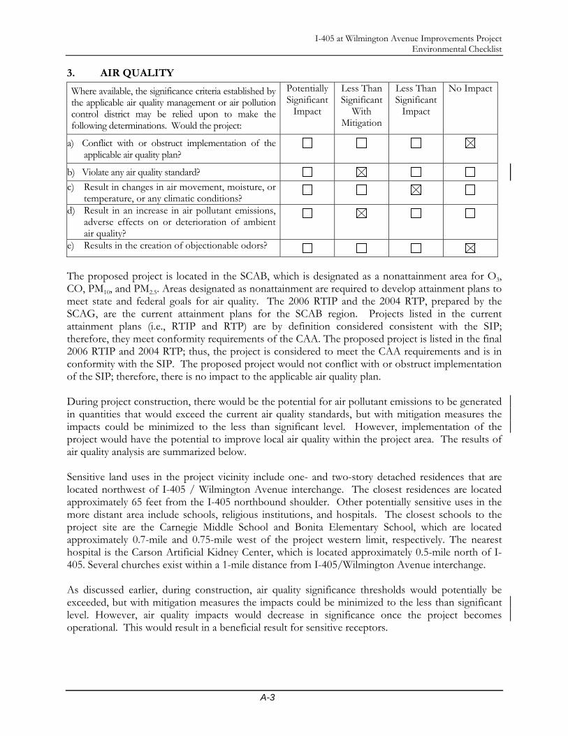
I-405 at Wilmington Avenue Improvements Project Environmental Checklist
A-3
3. AIR QUALITY
Where available, the significance criteria established by the applicable air quality management or air pollution control district may be relied upon to make the following determinations. Would the project:
Potentially Significant
Impact
Less Than Significant
With Mitigation
Less Than Significant
Impact
No Impact
a) Conflict with or obstruct implementation of the applicable air quality plan?
b) Violate any air quality standard?
c) Result in changes in air movement, moisture, or temperature, or any climatic conditions?
d) Result in an increase in air pollutant emissions, adverse effects on or deterioration of ambient air quality?
e) Results in the creation of objectionable odors?
The proposed project is located in the SCAB, which is designated as a nonattainment area for O3, CO, PM10, and PM2.5. Areas designated as nonattainment are required to develop attainment plans to meet state and federal goals for air quality. The 2006 RTIP and the 2004 RTP, prepared by the SCAG, are the current attainment plans for the SCAB region. Projects listed in the current attainment plans (i.e., RTIP and RTP) are by definition considered consistent with the SIP; therefore, they meet conformity requirements of the CAA. The proposed project is listed in the final 2006 RTIP and 2004 RTP; thus, the project is considered to meet the CAA requirements and is in conformity with the SIP. The proposed project would not conflict with or obstruct implementation of the SIP; therefore, there is no impact to the applicable air quality plan. During project construction, there would be the potential for air pollutant emissions to be generated in quantities that would exceed the current air quality standards, but with mitigation measures the impacts could be minimized to the less than significant level. However, implementation of the project would have the potential to improve local air quality within the project area. The results of air quality analysis are summarized below. Sensitive land uses in the project vicinity include one- and two-story detached residences that are located northwest of I-405 / Wilmington Avenue interchange. The closest residences are located approximately 65 feet from the I-405 northbound shoulder. Other potentially sensitive uses in the more distant area include schools, religious institutions, and hospitals. The closest schools to the project site are the Carnegie Middle School and Bonita Elementary School, which are located approximately 0.7-mile and 0.75-mile west of the project western limit, respectively. The nearest hospital is the Carson Artificial Kidney Center, which is located approximately 0.5-mile north of I-405. Several churches exist within a 1-mile distance from I-405/Wilmington Avenue interchange. As discussed earlier, during construction, air quality significance thresholds would potentially be exceeded, but with mitigation measures the impacts could be minimized to the less than significant level. However, air quality impacts would decrease in significance once the project becomes operational. This would result in a beneficial result for sensitive receptors.

I-405 at Wilmington Avenue Improvements Project Environmental Checklist
A-4
The proposed project would improve traffic flow and safety conditions at the interchange. No objectionable odors are expected to be created as a result of implementing the proposed project. No impacts from odor would occur.
4. BIOLOGICAL RESOURCES
Would the project: Potentially Significant
Impact
Less Than Significant
With Mitigation
Less Than Significant
Impact
No Impact
a) Have substantial adverse effects, either directly or through habitat modifications, on any species identified as a candidate, sensitive or special status species in local or regional plans, policies, or regulations, or by the California Department of Fish and Game or U.S. Fish and Wildlife Service?
b) Have a substantial adverse effect on any wetlands, riparian habitat or other sensitive natural community identified in local or regional plans, policies, and regulations or by the California Department of Fish and Game or U.S. Fish and Wildlife Service?
c) Change in the diversity of species, or numbers of any species of animals (birds, land animals including reptiles, fish and shellfish, benthic organisms, insects or micro fauna)?
d) Introduction of new species of plants into an area, or result in a barrier to the normal replenishment of existing species?
e) Introduction of new species of animals into an area, or result in a barrier to the migration of movement of animals?
f) Removal or deterioration of existing fish or wildlife habitat?
g) Conflict with any applicable habitat conservation plan, natural community conservation plan or other approved local, regional or state habitat plan?
h) Interfere substantially with the movement of any native resident or migratory fish or wildlife species or with established native resident or migratory wildlife corridors, or impede the use of native wildlife nursery sites?
i) Conflict with any applicable habitat conservation plan or natural community conservation plan?
The proposed project area is situated in a highly urbanized area in the City of Carson, outside the vicinity of any natural drainages, streams, or creeks. No sign of any listed species was observed anywhere within the biological area of potential effect. Similarly, designated critical habitat essential
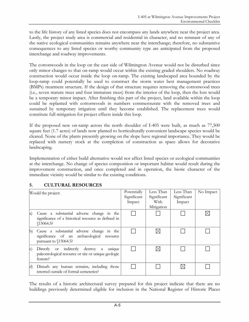
I-405 at Wilmington Avenue Improvements Project Environmental Checklist
A-5
to the life history of any listed species does not encompass any lands anywhere near the project area. Lastly, the project study area is commercial and residential in character, and no remnant of any of the native ecological communities remains anywhere near the interchange; therefore, no substantive consequences to any listed species or worthy community type are anticipated from the proposed interchange and roadway improvements. The cottonwoods in the loop on the east side of Wilmington Avenue would not be disturbed since only minor changes to that on-ramp would occur within the existing graded shoulders. No roadway construction would occur inside the loop on-ramp. The existing landscaped area bounded by the loop-ramp could potentially be used to construct the storm water best management practices (BMPs) treatment structure. If the design of that structure requires removing the cottonwood trees (i.e., seven mature trees and four immature trees) from the interior of the loop, then the loss would be a temporary minor impact. After finishing this part of the project, land available within the loop could be replanted with cottonwoods in numbers commensurate with the removed trees and sustained by temporary irrigation until they become established. The replacement trees would constitute full mitigation for project effects inside this loop. If the proposed new on-ramp across the north shoulder of I-405 were built, as much as 77,500 square feet (1.7 acres) of lands now planted to horticulturally convenient landscape species would be cleared. None of the plants presently growing on the slope have regional importance. They would be replaced with nursery stock at the completion of construction as space allows for decorative landscaping. Implementation of either build alternative would not affect listed species or ecological communities at the interchange. No change of species composition or important habitat would result during the improvement construction, and once completed and in operation, the biotic character of the immediate vicinity would be similar to the existing conditions.
5. CULTURAL RESOURCES
Would the project: Potentially Significant
Impact
Less Than Significant
With Mitigation
Less Than Significant
Impact
No Impact
a) Cause a substantial adverse change in the significance of a historical resource as defined in §15064.5?
b) Cause a substantial adverse change in the significance of an archaeological resource pursuant to §15064.5?
c) Directly or indirectly destroy a unique paleontological resource or site or unique geologic feature?
d) Disturb any human remains, including those interred outside of formal cemeteries?
The results of a historic architectural survey prepared for this project indicate that there are no buildings previously determined eligible for inclusion in the National Register of Historic Places
I-405 at Wilmington Avenue Improvements Project Environmental Checklist
A-6
(NAHP), and none of the properties within the APE had been given formal local designations of historical significance for the purposes of Section 106 of the NHPA or the NEPA. The historic architectural survey identified several buildings within the architectural or indirect APE, all of which meet the criteria for the Caltrans Section 106 PA Attachment 4 (Properties Exempt From Evaluation). Therefore, no properties that meet the definition of a “historic property” in accordance with Section 106 or a “historical resource” in accordance with Section 15064.5(a)(2)-(3) of the CEQA Guidelines, none of the properties are historical resources for the purposes of CEQA. No impacts to significant historical resources are anticipated. The results of a records search of the South Central Coastal Information Center at California State University, Fullerton, revealed that no archaeological resources were recorded within the project APE. A field inspection was conducted, and confirmed that no prehistoric or historic archaeological sites were identified in the APE. Based on this, no archaeological impacts are anticipated and no further archaeological investigations are warranted. However, the presence of significant subsurface archaeological resources is always a possibility in areas where only surface inspection has taken place. If potentially significant archaeological resources (e.g., stone artifacts, dark ashy soils burned rocks, old glass, metal, or ceramic artifacts) are discovered during ground disturbances, work in that location would be diverted and a qualified archaeologist would be contacted immediately to evaluate the resource. The archaeologist may recommend further study to evaluate the resource for significance. This project design feature would reduce any potential for impacts to less than significant. The results of the paleontological literature review indicate that substantive subsurface excavation within the boundaries of the project APE has the potential to expose significant nonrenewable paleontological resources. Vertebrate fossils have been encountered within the Older Quaternary Alluvium at depths ranging from 10 to 30 feet below the surface in the vicinity of the proposed project area. Ground disturbance is anticipated within the Older Quaternary Alluvium. Therefore, a qualified vertebrate paleontologist is required to develop a monitoring program to mitigate the impacts to nonrenewable paleontological resources. The monitoring program may include monitoring of initial grading activities, as well as recovery, preparation (to a point of identification), cataloguing, and curation of fossil materials. Also, a preconstruction meeting would be conducted in which the project paleontologist will explain the procedures necessary to protect and safely remove potentially significant fossil materials for study and curation. The methods employed during monitoring, and/or recovery of fossil specimens should be documented in a report of findings. Any fossils that are collected should be inventoried and placed in an accredited scientific institution for curation. These measures would reduce any potential impacts to significant nonrenewable paleontological resources to less than significant. Historic records do not indicate the presence of cemeteries or Native American burial grounds within the proposed project area. The project site has been previously disturbed by construction of the existing freeway, buildings, pavement, and landscaping. Therefore, it is not expected that project implementation would disturb any human remains. However, this does not preclude the possibility that subsurface cultural deposits, including human remains, may be present within the project area. Grading or excavation activities could impact undiscovered resources such as human remains. It is Caltrans’ policy to stop work until a qualified archaeologist can evaluate the nature and significance of the find. If human remains are found during ground disturbance, under state law the Los Angeles County Coroner’s office must be notified immediately and all activity in that area must cease until

I-405 at Wilmington Avenue Improvements Project Environmental Checklist
A-7
appropriate measures have been implemented. If the Coroner determines that the remains are Native American, the NAHC must also be contacted. The NAHC will designate a Most Likely Descendent (MLD) who will make recommendations concerning the discovery. This impact would be considered less than significant with implementation of these measures.
6. GEOLOGY AND SOILS
Would the project:
a) Expose people or structures to potential substantial adverse effects, including the risk of loss, injury, or death involving:
Potentially significant
Impact
Less Than Significant
With Mitigation
Less Than Significant
Impact
No Impact
i. Rupture of a known earthquake fault, as delineated on the most recent Alquist-Priolo Earthquake Fault Zoning Map issued by the State Geologist for the area or based on other substantial evidence of a known fault? Refer to Division of Mines and Geology Special Publication 42.
ii. Strong seismic ground shaking?
iii. Seismic-related ground failures and hazards, including liquefaction?
iv. Landslides?
b) Result in or be affected by substantial soil erosion or siltation (whether by water or wind), or result in the loss of topsoil?
c) Be located on a geologic unit or soil that is unstable, or that would become unstable as a result of the project, and potentially result in on- or offsite landslide, lateral spreading, subsidence, or collapse?
d) Be located on expansive soil, as defined in Table 18-1-B of the Uniform Building Code (1994), creating substantial risks of life or property?
e) Have soils incapable of adequately supporting the use of septic tanks or alternative wastewater disposal systems where sewers are not available for the disposal of wastewater?
f) Appreciably change the topography or ground surface relief features?
g) Destroy, cover, or modify any unique geologic or physical features?
The project site is situated in a seismically active region. As is the case for most areas of Southern California, ground-shaking resulting from earthquakes associated with nearby and more distant faults may occur at the project site. Secondary effects of seismic activity include surface fault rupture,
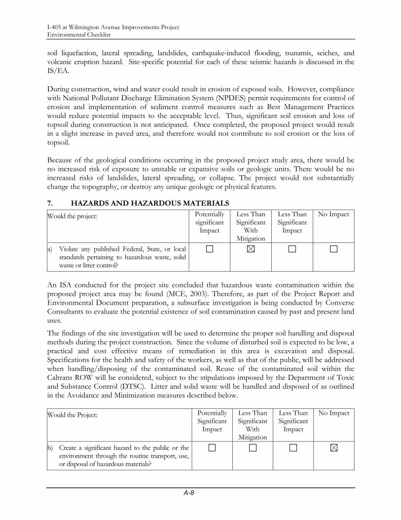
I-405 at Wilmington Avenue Improvements Project Environmental Checklist
A-8
soil liquefaction, lateral spreading, landslides, earthquake-induced flooding, tsunamis, seiches, and volcanic eruption hazard. Site-specific potential for each of these seismic hazards is discussed in the IS/EA. During construction, wind and water could result in erosion of exposed soils. However, compliance with National Pollutant Discharge Elimination System (NPDES) permit requirements for control of erosion and implementation of sediment control measures such as Best Management Practices would reduce potential impacts to the acceptable level. Thus, significant soil erosion and loss of topsoil during construction is not anticipated. Once completed, the proposed project would result in a slight increase in paved area, and therefore would not contribute to soil erosion or the loss of topsoil. Because of the geological conditions occurring in the proposed project study area, there would be no increased risk of exposure to unstable or expansive soils or geologic units. There would be no increased risks of landslides, lateral spreading, or collapse. The project would not substantially change the topography, or destroy any unique geologic or physical features.
7. HAZARDS AND HAZARDOUS MATERIALS
Would the project: Potentially significant
Impact
Less Than Significant
With Mitigation
Less Than Significant
Impact
No Impact
a) Violate any published Federal, State, or local standards pertaining to hazardous waste, solid waste or litter control?
An ISA conducted for the project site concluded that hazardous waste contamination within the proposed project area may be found (MCE, 2003). Therefore, as part of the Project Report and Environmental Document preparation, a subsurface investigation is being conducted by Converse Consultants to evaluate the potential existence of soil contamination caused by past and present land uses.
The findings of the site investigation will be used to determine the proper soil handling and disposal methods during the project construction. Since the volume of disturbed soil is expected to be low, a practical and cost effective means of remediation in this area is excavation and disposal. Specifications for the health and safety of the workers, as well as that of the public, will be addressed when handling/disposing of the contaminated soil. Reuse of the contaminated soil within the Caltrans ROW will be considered, subject to the stipulations imposed by the Department of Toxic and Substance Control (DTSC). Litter and solid waste will be handled and disposed of as outlined in the Avoidance and Minimization measures described below. Would the Project: Potentially
Significant Impact
Less Than Significant
With Mitigation
Less Than Significant
Impact
No Impact
b) Create a significant hazard to the public or the environment through the routine transport, use, or disposal of hazardous materials?

I-405 at Wilmington Avenue Improvements Project Environmental Checklist
A-9
c) Create a significant hazard to the public or the environment through reasonably foreseeable upset and accident/non-accident conditions involving the release of hazardous materials into the environment?
d) Involve a substantial risk of an explosion or in any way affect overall public safety?
The proposed project itself would not create a significant hazard to the public or the environment through the routine transport, use, or disposal of hazardous material, or increase the risk of an explosion or the release of hazardous substances into the environment or adversely affect overall public safety. However, this type of hazard could occur from other sources in the project area since most of the land uses are commercial and industrial dominated. Implementation of the project would alleviate traffic congestion and conflicting movement at the I-405 and Wilmington Avenue interchange, thus minimizing the potential for traffic hazards.
8. HYDROLOGY AND WATER QUALITY
Would the project: Potentially significant
Impact
Less Than Significant
With Mitigation
Less Than Significant
Impact
No Impact
a) Violate or be inconsistent with Federal, State or local water quality standards or waste discharge requirements?
b) Substantially deplete groundwater supplies or interfere substantially with groundwater recharge such that there would be a net deficit in aquifer volume or a lowering of the local groundwater table level (e.g., the production rate of pre-existing nearby wells would drop to a level that would not support existing land uses or planned uses for which permits have been granted)?
c) Substantially alter the existing drainage pattern of the site or area, including through the alteration of the course of a stream or river, or substantially increase the rate or amount of surface runoff in a manner that would result in flooding on- or offsite?
d) Create or contribute runoff water that would exceed the capacity of existing or planned stormwater drainage systems or provide substantial additional sources of polluted runoff?
e) Otherwise substantially degrade water quality?
f) Place housing within a 100-year flood hazard area as mapped on a federal Flood Hazard Boundary or Flood Insurance Rate Map or other flood hazard delineation map ?

I-405 at Wilmington Avenue Improvements Project Environmental Checklist
A-10
Would the project: Potentially significant
Impact
Less Than Significant
With Mitigation
Less Than Significant
Impact
No Impact
g) Modify the channel of a river or stream or the bed of the ocean or any bay, inlet or lake?
h) Encroach upon a floodplain or result in or be affected by floodwaters or tidal waves?
i) Adversely affect the quantity or quality of surface water, groundwater, or public water supply?
j) Result in the use of water in large amounts or in a wasteful manner?
k) Affect wild or scenic rivers or natural landmarks?
l) Place within a 100-year flood hazard area structures that would impede or redirect flood flows?
m) Expose people or structures to a significant risk of loss, injury, or death involving flooding, including flooding as a result of the failure of a levee or dam?
n) Expose people or structures to inundation by Seishi, tsunami, or mudflow?
The proposed project would not create or contribute runoff that would exceed the capacity of the existing storm water drainage system, or provide substantial additional sources of polluted runoff that would violate or be inconsistent with any federal, State or local water quality standards. The proposed project would not substantially alter the existing drainage pattern and would not substantially deplete groundwater supplies or interfere with groundwater recharge. The proposed project will place piles in the Dominguez Channel; however, through the hydrologic analysis performed as part of the Hydrology, Floodplain, Water Quality, and Stormwater Runoff Impact Analysis (Parsons 2007d), it has been determined that this would not substantially impede or redirect the flow, or exceed the capacity of the channel. The proposed project will encroach upon a floodplain; however, flooding in this area is typically confined to the Dominguez Channel, and structures that will be utilized to facilitate bridge widening are designed to be placed in the flow line. This would not result in the exposure of people or structures to a significant risk of loss, injury, or death involving flooding. Short-term water quality impacts would occur during construction of the proposed project; however, with the implementation of Construction Site BMPs, no adverse impacts to water quality from construction are anticipated. Since Treatment BMPs (Media Filter) designed to remove pollutants from runoff are proposed with this project, no adverse impacts to water quality from operations are anticipated.

I-405 at Wilmington Avenue Improvements Project Environmental Checklist
A-11
9. NATURAL RESOURCES
Would the Project: Potentially significant
Impact
Less Than Significant
With Mitigation
Less Than Significant
Impact
No Impact
a) Result in the increased use of fuel or energy in large amounts or in a wasteful manner?
b) Result in an increase in the rate of use of any natural resource?
c) Result in the substantial depletion of any nonrenewable resource?
d) Result in the loss of availability of a known mineral resource that would be of value to the region and the residents of the State?
e) Result in the loss of availability of a locally important mineral resource recovery site delineated on a local general plan, specific plan, or other land use plan?
f) Result in the loss of availability of a known mineral resource or locally important mineral resource recovery site, that would be of value to the region and the residents of the state?
The proposed project is located in a highly urbanized area of the City of Carson. No mineral resources that would be of value to the region or residents of the state have been identified in the vicinity of the project site. The State Department of Conservation does not designate the project site as a Significant Mineral Aggregate Resources Area; thus, no impacts resulting from the loss of mineral resources are anticipated. During project construction fossil fuels would be consumed from construction equipment and worker vehicle operation. The increased fuel consumption would be temporary and would cease at the end of the construction activity. Once the project is under operation, traffic flow within the project limits would be improved, resulting in some energy savings to the operating vehicles. No adverse impact would occur.
10. LAND USE AND PLANNING
Would the project: Potentially significant
Impact
Less Than Significant
With Mitigation
Less Than Significant
Impact
No Impact
a) Conflict with any applicable land use plan, policy, or regulation of an agency with jurisdiction over the project (including, but not limited to, the general plan, specific plan, local coastal program, or zoning ordinance) adopted for the purpose of avoiding or mitigating an environmental effect?
I-405 at Wilmington Avenue Improvements Project Environmental Checklist
A-12
The proposed project is compatible with all existing land use and environmental plans and policies, and it would not require any modification or change to any existing zoning or land use. The proposed project aims to enhance roadway capacity, reduce conflicting movements, and alleviate traffic congestion at the local intersections within Carson. The project is located within a highly developed area with a mix of land uses including industrial, commercial, and residential. Growth within the project area and vicinity is controlled by the City of Carson General Plan. The proposed improvements to the I-405/Wilmington Avenue interchange would accommodate planned growth and relieve congestion within the project locality. The project is consistent with adopted local plan. Would the Project: Potentially
Significant Impact
Less Than Significant
With Mitigation
Less Than Significant
Impact
No Impact
b) Cause disruption of orderly planned development?
c) Support large commercial or residential development?
d) Be inconsistent with a Coastal Zone Management Plan?
The project site is located in a highly developed area of Carson. Based on the City of Carson Web site, 11 major businesses are located within a 2.5-mile radius of the project site. Although no major new development within the immediate vicinity of the project site is expected, more car dealership development could be established along 223rd Street west of Wilmington Avenue since the City of Carson has designated 223rd Street, west of the Dominguez Channel, as “Auto Row.” Implementation of the proposed project would facilitate access to the planned “Auto Row” designation along 223rd Street. No other large commercial or residential developments are known to be planned within the vicinity of the project. Therefore, the proposed project does not support any planned large commercial or residential developments, other than the potential expansion of an already-designated land use. The proposed project area is not located within the Coastal Zone.
11. SOCIAL AND ECONOMIC
Would the project: Potentially significant
Impact
Less Than Significant
With Mitigation
Less Than Significant
Impact
No Impact
a) Affect life-styles, or neighborhood character or stability, or physically divide an established community?
Implementation of either of the Build Alternatives would not result in any disconnection or division of any community or neighborhood area because they would improve existing facilities. The
I-405 at Wilmington Avenue Improvements Project Environmental Checklist
A-13
proposed build alternatives would not eliminate any community service facilities currently existing within the neighboring area; therefore, there would be no impact to community cohesion because of the implementation of either project alternative. The proposed project is not anticipated to affect life styles, neighborhood character or stability since it would improve an existing facility. The proposed project would not physically divide an established community or force the relocation of any residential properties. The project would enhance the existing facility by promoting safer and more efficient traffic circulation with easier access to various communities in the vicinity of the proposed project. Would the Project: Potentially
Significant Impact
Less Than Significant
With Mitigation
Less Than Significant
Impact
No Impact
b) Affect employment, industry or commerce, or require the displacement of businesses or farms?
Construction of Alternative 1 would require a full ROW acquisition of one parcel and partial acquisition of nine parcels; two additional partial ROW acquisitions would be required for Alternative 2. The full ROW acquisition would be required of Parcel #7315-008-902, which is located at the southeast corner of Wilmington Avenue and 223rd Street and is owned by Los Angeles County Flood Control District. However, no relocation of the existing industries or businesses would be required. During project construction, a temporary closure of one driveway access point for the Chevron Gas Station (APN#: 7315-040-011), located at 22222 Wilmington Avenue, and the Shell Gas Station (APN#: 7315-040-001), located at 22232 Wilmington Avenue, would be required by both Alternatives 1 and 2. At least one driveway access point to both the Shell and Chevron gas stations would be maintained at all times during the construction period. No business closures would be required. No effect to employment either during construction or operation are anticipated. Would the Project: Potentially
Significant Impact
Less Than Significant
With Mitigation
Less Than Significant
Impact
No Impact
c) Affect property values or the local tax base?
The proposed build alternatives would relieve traffic congestion and traffic movement conflicts at the I-405/Wilmington Avenue interchange, which would alleviate the loss of time and inconvenience for local businesses, commuters, and residents within the locality. The proposed build alternatives would not cause any business displacement or residential relocation, although minor ROW from some business properties would be required (see Table 16 for ROW requirements). Proposed Alternatives 1 and 2 would not result in a measurable effect on property tax or sales tax revenues within Carson.

I-405 at Wilmington Avenue Improvements Project Environmental Checklist
A-14
Would the Project: Potentially Significant
Impact
Less Than Significant
With Mitigation
Less Than Significant
Impact
No Impact
d) Affect any community facilities (including medical, educational, scientific, recreational, or religious institutions, ceremonial sites or sacred shrines)?
Proposed Alternatives 1 and 2 would not result in any impacts to community service facilities, including health care and recreational facilities. No places of worship, childcare, or school facilities would be affected by either build alternative. Alternatives 1 and 2 would not increase the need for emergency services or adversely affect implementation of performance objectives for police and fire protection. Law enforcement and fire protection emergency response services would likely benefit from improved traffic circulation that would result from project implementation.
Would the Project: Potentially
Significant Impact
Less Than Significant
With Mitigation
Less Than Significant
Impact
No Impact
e) Expose people or structures to a significant risk of loss, injury or death involving wildland fires, including where wildlands are adjacent to urbanized areas or where residences are intermixed with wildlands?
Not applicable. The project setting is in a highly urbanized area in the City of Carson. There are no wildlands within or immediately adjacent to the proposed project site. Would the Project: Potentially
Significant Impact
Less Than Significant
With Mitigation
Less Than Significant
Impact
No Impact
f) Result in substantial impacts associated with construction activities (e.g., noise, dust, temporary drainage, traffic detours and temporary access, etc.)?
Construction of the proposed project would take approximately two years to complete, the longest phase of which would be for the work at the bridge of approximately eight months. Construction activities would result in localized disruption to the surrounding communities and commuters. These impacts are typical for roadway improvement projects, and they are commonly experienced in dense urban settings such as the study area. The City of Carson would implement specific measures to minimize construction impacts on community functions and residential/business activities in the project area to a practicable level.
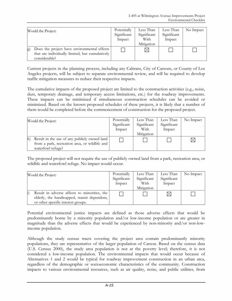
I-405 at Wilmington Avenue Improvements Project Environmental Checklist
A-15
Would the Project: Potentially Significant
Impact
Less Than Significant
With Mitigation
Less Than Significant
Impact
No Impact
g) Does the project have environmental effects that are individually limited, but cumulatively considerable?
Current projects in the planning process, including any Caltrans, City of Carsons, or County of Los Angeles projects, will be subject to separate environmental review, and will be required to develop traffic mitigation measures to reduce their respective impacts. The cumulative impacts of the proposed project are limited to the construction activities (e.g., noise, dust, temporary drainage, and temporary access limitations, etc.) for the roadway improvements. These impacts can be minimized if simultaneous construction schedules can be avoided or minimized. Based on the known proposed schedules of these projects, it is likely that a number of them would be completed before the commencement of construction for the proposed project. Would the Project: Potentially
Significant Impact
Less Than Significant
With Mitigation
Less Than Significant
Impact
No Impact
h) Result in the use of any publicly owned land from a park, recreation area, or wildlife and waterfowl refuge?
The proposed project will not require the use of publicly owned land from a park, recreation area, or wildlife and waterfowl refuge. No impact would occur. Would the Project: Potentially
Significant Impact
Less Than Significant
With Mitigation
Less Than Significant
Impact
No Impact
i) Result in adverse affects to minorities, the elderly, the handicapped, transit dependent, or other specific interest groups.
Potential environmental justice impacts are defined as those adverse effects that would be predominantly borne by a minority population and/or low-income population or are greater in magnitude than the adverse effects that would be experienced by non-minority and/or non-low-income population. Although the study census tracts covering the project area contain predominantly minority populations, they are representative of the larger population of Carson. Based on the census data (U.S. Census 2000), the study area population is not at the poverty level; therefore, it is not considered a low-income population. The environmental impacts that would occur because of Alternatives 1 and 2 would be typical for roadway improvement construction in an urban area, regardless of the demographic or socioeconomic characteristics of the community. Construction impacts to various environmental resources, such as air quality, noise, and public utilities, from

I-405 at Wilmington Avenue Improvements Project Environmental Checklist
A-16
construction activities, would be temporary, and they would be avoided or minimized to the extent possible as mitigation for the proposed project. The proposed project would not disproportionately affect minority or low-income population compared to the larger population within Carson; therefore, the proposed project would not cause environmental justice impacts within the meaning of EO 12898. The proposed project would require partial ROW acquisitions from five businesses and one full acquisition from the Los Angeles County Flood Control District. The other eight potentially affected properties have not been developed, and only partial acquisition would be required. No ROW acquisitions would be required of any residential units, public/community service facilities, parks, or schools. The primary purpose of the project is to provide future congestion relief to improve traffic flow on the local transportation system. After project completion, Alternatives 1 and 2 would result in traffic and circulation benefits to all communities (i.e., both low- and high-income, and minority and majority populations) in the vicinity and to commuters from outside of the area. Elderly, handicapped, transit-dependent, or other specific interest groups would not be adversely affected by the project, except possibly during construction due to increased traffic congestion, noise, dust, etc. These impacts will only be temporary in nature, and thus not considered to be significant. Please see checklist item (#11f) for a discussion of temporary construction related impacts as a result of proposed project. Pedestrian access at the intersection would be affected temporarily during construction. Pedestrians would not be allowed in construction areas, and thus pedestrian traffic would be re-routed. Wheel chair accessible ramps will be maintained at each affected corner during and after construction of the proposed project. Furthermore, the Caltrans’s design is in conformance with the Americans with Disabilities Act Accessibility Guidelines (ADAAG) which require a minimum clearance width of at least 3 feet for an accessible route. Since the proposed project has, as its purpose, the improvement of traffic flow and reduced conflicts, bus transit would benefit from the reduced congestion and travel times would be reduced.
12. POPULATION AND HOUSING
Would the project: Potentially significant
Impact
Less Than Significant
With Mitigation
Less Than Significant
Impact
No Impact
a) Induce substantial population growth in an area, either directly (for example, by proposing new homes and businesses) or indirectly (for example, through extension or roads or other infrastructure)?
b) Displace substantial numbers of existing housing, necessitating the construction of replacement housing elsewhere?
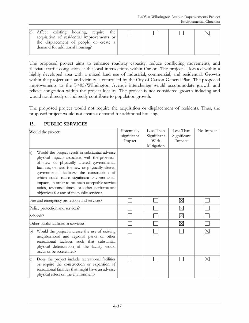
I-405 at Wilmington Avenue Improvements Project Environmental Checklist
A-17
c) Affect existing housing, require the acquisition of residential improvements or the displacement of people or create a demand for additional housing?
The proposed project aims to enhance roadway capacity, reduce conflicting movements, and alleviate traffic congestion at the local intersections within Carson. The project is located within a highly developed area with a mixed land use of industrial, commercial, and residential. Growth within the project area and vicinity is controlled by the City of Carson General Plan. The proposed improvements to the I-405/Wilmington Avenue interchange would accommodate growth and relieve congestion within the project locality. The project is not considered growth inducing and would not directly or indirectly contribute to population growth. The proposed project would not require the acquisition or displacement of residents. Thus, the proposed project would not create a demand for additional housing.
13. PUBLIC SERVICES
Would the project: Potentially significant
Impact
Less Than Significant
With Mitigation
Less Than Significant
Impact
No Impact
a) Would the project result in substantial adverse physical impacts associated with the provision of new or physically altered governmental facilities, or need for new or physically altered governmental facilities, the construction of which could cause significant environmental impacts, in order to maintain acceptable service ratios, response times, or other performance objectives for any of the public services:
Fire and emergency protection and services?
Police protection and services?
Schools?
Other public facilities or services?
b) Would the project increase the use of existing neighborhood and regional parks or other recreational facilities such that substantial physical deterioration of the facility would occur or be accelerated?
c) Does the project include recreational facilities or require the construction or expansion of recreational facilities that might have an adverse physical effect on the environment?

I-405 at Wilmington Avenue Improvements Project Environmental Checklist
A-18
Proposed Alternatives 1 and 2 would not result in impacts to community service facilities, including health care and recreational facilities. No places of worship, child care, or school facilities would be affected by either build alternative. A TMP would be developed prior to construction in order to minimize these traffic impacts. The potentially affected agencies, as well as all applicable public safety personnel of the City of Carson, would be notified of the proposed project, and their input would be incorporated into the TMP to avoid any unacceptable response time issues that would endanger the public. The proposed project does not include new residential, commercial, or industrial development or other such uses. Thus the proposed project would not increase the need for additional fire protection, law enforcement services, public utilities, or result in increases in student enrollment at nearby schools. The proposed project would not induce a population increase in the area, nor would it include new residential, commercial, or industrial development or uses. Thus, the proposed project would not increase the demand or use of existing parks and other facilities in the area.
14. UTILITIES AND SERVICE SYSTEMS
Would the project: Potentially significant
Impact
Less Than Significant
With Mitigation
Less Than Significant
Impact
No Impact
a) Exceed wastewater treatment requirements of the applicable Regional Water Quality Control Board?
b) Require or result in the construction of new water or wastewater treatment facilities or expansion of existing facilities, the construction of which could cause significant environmental effects?
c) Result in a determination by the wastewater treatment provider that services or may serve the project that it has adequate capacity to serve the project’s projected demand in addition to the provider’s existing commitments?
d) Require or result in the construction of new stormwater drainage facilities or expansion of existing facilities, the construction of which could cause significant environmental effects?
e) Have sufficient water supplies available to serve the project from existing entitlements and resources, or are new or expanded entitlements needed?
f) Be served by a landfill with sufficient permitted capacity to accommodate the project’s solid waste disposal needs?
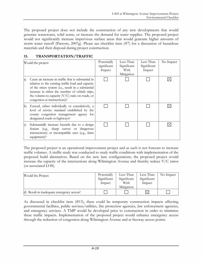
I-405 at Wilmington Avenue Improvements Project Environmental Checklist
A-19
The proposed project does not include the construction of any new developments that would generate wastewater, solid waste, or increase the demand for water supplies. The proposed project would not significantly increase impervious surface areas that would generate higher amounts of storm water runoff (Parsons, 2007g). Please see checklist item (#7) for a discussion of hazardous materials and their disposal during project construction.
15. TRANSPORTATION/TRAFFIC
Would the project: Potentially significant
Impact
Less Than Significant
With Mitigation
Less Than Significant
Impact
No Impact
a) Cause an increase in traffic that is substantial in relation to the existing traffic load and capacity of the street system (i.e., result in a substantial increase in either the number of vehicle trips, the volume-to-capacity (V/C) ratio on roads, or congestion at intersections)?
b) Exceed, either individually or cumulatively, a level of service standard established by the county congestion management agency for designated roads or highways?
c) Substantially increase hazards due to a design feature (e.g., sharp curves or dangerous intersections) or incompatible uses (e.g., farm equipment)?
The proposed project is an operational improvement project and as such is not forecast to increase traffic volumes. A traffic study was conducted to study traffic conditions with implementation of the proposed build alternatives. Based on the new lane configurations, the proposed project would increase the capacity of the intersections along Wilmington Avenue and thereby reduce V/C ratios (or associated LOS). Would the Project: Potentially
Significant Impact
Less Than Significant
With Mitigation
Less Than Significant
Impact
No Impact
d) Result in inadequate emergency access?
As discussed in checklist item (#13), there could be temporary construction impacts affecting governmental facilities, public services/utilities, fire protection agencies, law enforcement agencies, and emergency services. A TMP would be developed prior to construction in order to minimize these traffic impacts. Implementation of the proposed project would enhance emergency access through the reduction of congestion along Wilmington Avenue and at freeway access points.

I-405 at Wilmington Avenue Improvements Project Environmental Checklist
A-20
Would the Project: Potentially Significant
Impact
Less Than Significant
With Mitigation
Less Than Significant
Impact
No Impact
e) Result in alterations to waterborne, rail or air traffic? Result in a change in location that results in substantial safety risks?
There is a railroad crossing of Wilmington Avenue within the project area. No changes to that crossing are proposed. No changes in safety risks are anticipated. Would the Project: Potentially
Significant Impact
Less Than Significant
With Mitigation
Less Than Significant
Impact
No Impact
f) Result in inadequate parking capacity?
g) Affect or be affected by existing parking facilities or result in demand of new parking?
Land potentially to be acquired from the Shell gasoline station (APN 7315-040-001) on the west side of Wilmington Avenue north of 223rd Street will result in the potential loss of up to four parking stalls. A mini-market with Subway sandwich shop is located on the site. The two existing stalls closest to Wilmington Avenue along the northern edge of the site will potentially be removed. Additionally, two stalls in the southwest corner of the site will potentially be removed. With redesign of the parking layout, the four stalls potentially removed can be recovered. Currently there are five stalls along the north edge of the site and two stalls located in the southwest corner of the site. With redesign four stalls can be located along the north edge of the site and at least three could be located in the southwest corner of the site. This would restore the number of current parking stalls on the site.
No parking facilities, other than at the Shell gasoline station as noted above, are affected by the proposed project. Parking is not currently permitted along Wilmington Avenue within the project limits and this will not be changed by the proposed project. The project is limited to roadway improvements and would therefore not result in any increase in demand for parking. Would the Project: Potentially
Significant Impact
Less Than Significant
With Mitigation
Less Than Significant
Impact
No Impact
h) Have substantial impact on existing transportation systems or alter present patterns of circulation or movement of people and/or goods?
The proposed project would improve traffic conditions. It is anticipated that the proposed project would improve circulation of vehicles on roadways within the project limits. Circulation would be altered by the implementation of a ramp from SB Wilmington Avenue to NB I-405. Vehicles will enter the ramp by turning right off of Wilmington Avenue. Currently, SB traffic on Wilmington

I-405 at Wilmington Avenue Improvements Project Environmental Checklist
A-21
Avenue must turn left to access I-405 NB. The proposed project would improve the LOS at the intersection in the project area, and would result in some travel time savings as demonstrated in Answer to Checklist #15 a-c above. Would the Project: Potentially
Significant Impact
Less Than Significant
With Mitigation
Less Than Significant
Impact
No Impact
i) Conflict with adopted policies, plans, or programs supporting alternative transportation (e.g., bus turnouts, bicycle racks)?
A Class I bikeway along Dominguez Channel is shown in the current Transportation/Circulation Element of the Carson General Plan. The bikeway does not currently exist. The proposed project would potentially widen existing bridges over the channel but, since the bikeway does not currently exist, no impacts are expected as a result of the proposed project. The only transit service within the proposed project limits is provided by the Carson Circuit Transit System. The current map of shuttle bus Route F shows a major stop at the intersection of Wilmington Avnue and 223rd Street. That stop is located on 223rd Street west of the bridge over the Dominguez Channel. There is another stop on 220th Street west of Wilmington Avenue. No shelter or other fixed transit facility (except for signs designating stop locations which are mounted on signposts primarily for other signs) currently exists within the proposed project limits, so no impacts are expected as a result of the proposed project.
16. NOISE
Would the project: Potentially significant
Impact
Less Than Significant
With Mitigation
Less Than Significant
Impact
No Impact
a) Exposure of persons to excessive groundborne vibration or groundborne noise levels?
b) Exposure of persons to or generation of noise levels In excess of standards established in the local general plan or noise ordinance, or applicable standards of other agencies?
c) A substantial permanent increase in ambient noise levels in the project vicinity above levels existing without the project?
d) A substantial temporary or periodic increase in ambient noise levels in the project vicinity above levels existing without the project?
Construction Phase During construction of the project, noise from construction activities may intermittently dominate the noise environment in the immediate surrounding area. Construction noise impacts are addressed in Section 2.10 of this IS/EA document.
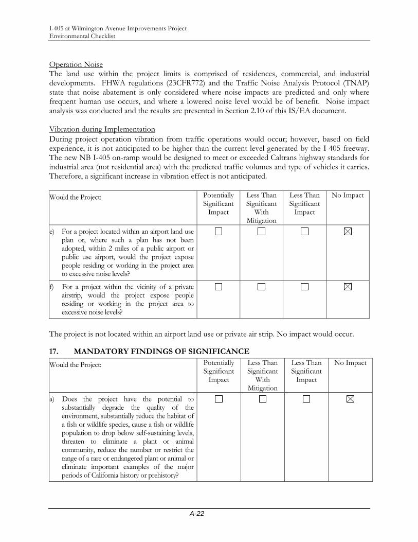
I-405 at Wilmington Avenue Improvements Project Environmental Checklist
A-22
Operation Noise The land use within the project limits is comprised of residences, commercial, and industrial developments. FHWA regulations (23CFR772) and the Traffic Noise Analysis Protocol (TNAP) state that noise abatement is only considered where noise impacts are predicted and only where frequent human use occurs, and where a lowered noise level would be of benefit. Noise impact analysis was conducted and the results are presented in Section 2.10 of this IS/EA document. Vibration during Implementation During project operation vibration from traffic operations would occur; however, based on field experience, it is not anticipated to be higher than the current level generated by the I-405 freeway. The new NB I-405 on-ramp would be designed to meet or exceeded Caltrans highway standards for industrial area (not residential area) with the predicted traffic volumes and type of vehicles it carries. Therefore, a significant increase in vibration effect is not anticipated. Would the Project: Potentially
Significant Impact
Less Than Significant
With Mitigation
Less Than Significant
Impact
No Impact
e) For a project located within an airport land use plan or, where such a plan has not been adopted, within 2 miles of a public airport or public use airport, would the project expose people residing or working in the project area to excessive noise levels?
f) For a project within the vicinity of a private airstrip, would the project expose people residing or working in the project area to excessive noise levels?
The project is not located within an airport land use or private air strip. No impact would occur.
17. MANDATORY FINDINGS OF SIGNIFICANCE
Would the Project: Potentially Significant
Impact
Less Than Significant
With Mitigation
Less Than Significant
Impact
No Impact
a) Does the project have the potential to substantially degrade the quality of the environment, substantially reduce the habitat of a fish or wildlife species, cause a fish or wildlife population to drop below self-sustaining levels, threaten to eliminate a plant or animal community, reduce the number or restrict the range of a rare or endangered plant or animal or eliminate important examples of the major periods of California history or prehistory?

I-405 at Wilmington Avenue Improvements Project Environmental Checklist
A-23
As discussed in checklist item (#4), the proposed project area is situated in a highly urbanized area in the City of Carson, outside the vicinity of any natural drainages, streams, or creeks. Dominguez Chanel is a manmade flood control channel. The proposed project area was deemed absent of any native vegetation, and absent of any as sensitive, threatened, endangered, and proposed plant and animal species habitat, aquatic or terrestrial. The proposed project would not adversely affect wetlands, wildlife corridors, species diversity, or impede any habitat conservation efforts. Would the Project: Potentially
Significant Impact
Less Than Significant
With Mitigation
Less Than Significant
Impact
No Impact
b) Does the project have environmental effects that are individually limited, but cumulatively considerable? Cumulatively considerable means that the incremental effects of an individual project are considerable when viewed in connection with the effects of past projects, the effects of other current projects, and the effects probable future projects. It includes the effects of other projects that interact with this project and, together, are considerable.
As discussed in checklist item (#11g), current projects in the planning process, including Caltrans, City of Carson, or County of Los Angeles projects, will be subject to their own environmental review, and will be required to develop traffic mitigation measures to reduce their respective impacts. The cumulative impacts of this proposed project will be limited to the construction activities (e.g., noise, dust, temporary drainage, and temporary access, etc.) for this roadway improvement. These impacts can be minimized if simultaneous construction schedules can be avoided. Would the Project: Potentially
Significant Impact
Less Than Significant
With Mitigation
Less Than Significant
Impact
No Impact
c) Does the project have environmental effects that will cause substantial adverse effects on human beings, either directly or indirectly?
As analyzed and discussed in checklist items (#1-16), the proposed project will not pose significantly adverse effects on human beings either directly or indirectly.

I-405 at Wilmington Avenue Improvements Project Environmental Checklist
A-24
Would the Project: Potentially Significant
Impact
Less Than Significant
With Mitigation
Less Than Significant
Impact
No Impact
d) Does the project have the potential to achieve short-term, to the disadvantage of long-term, environmental goals? (A short-term impact on the environment is one that occurs in a relatively brief, definitive period of time while long-term impacts will endure well into the future.)
The proposed project does not have the potential to achieve short-term, to the disadvantage of long-term, environmental goals. On the contrary, the proposed project will improve traffic movement in the general vicinity, thereby lowering the concentration of pollutants emitted by motor vehicles. The proposed intersection improvement project is a small, localized project that is intended to improve the existing traffic conditions in and around the project area, which is a long term benefit to the area residents and businesses as well as commuters using Wilmington Avenue and nearby local streets. The project is not anticipated to have the potential to significantly impact the region at large. The proposed project does not call to build anything new, or to physically expand or extend any roadways. Thus the proposed project will not induce or invite growth or development in or around the proposed project area.

Appendix B Notice of Initiation of Studies (NOIS) and Newspaper
Advertisement for Open House


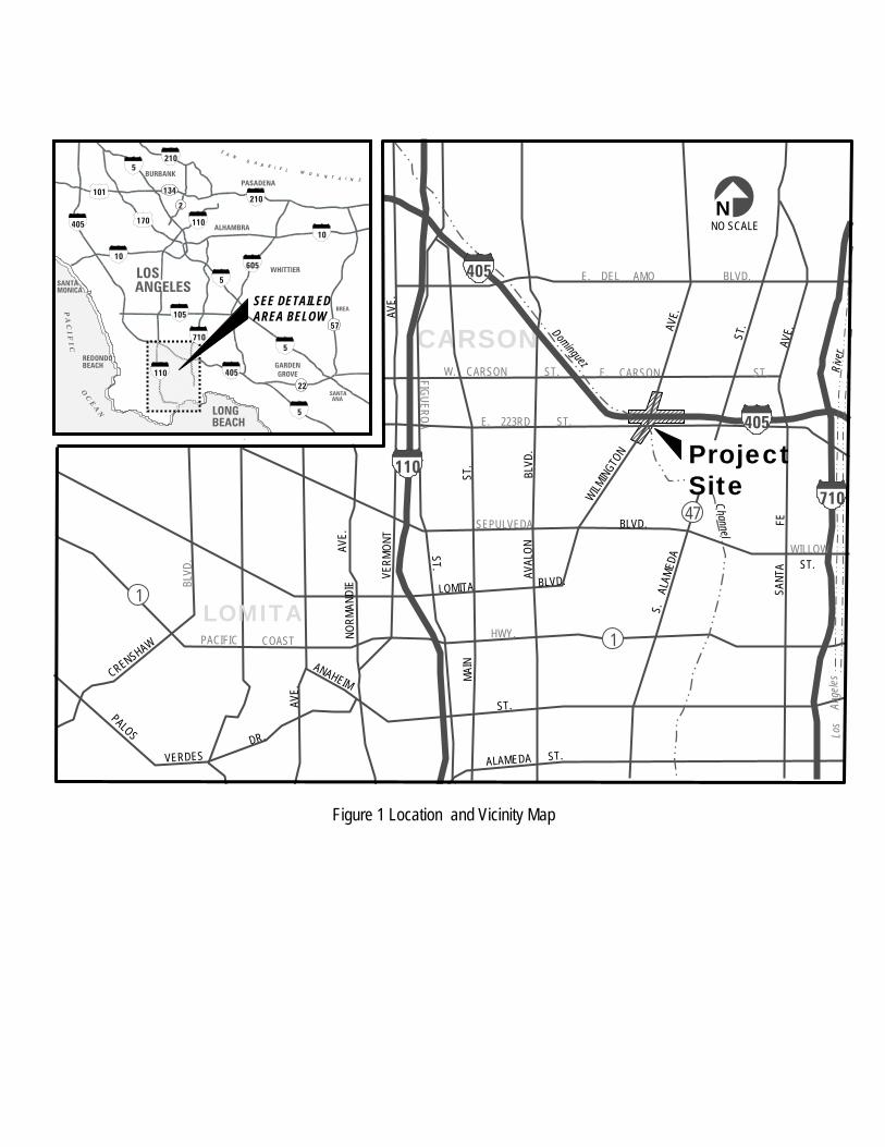
ROLLINGHILLS
ESTATES
47
WES
TERN
PALOSVERDES DR.
E.LOMITA
CARSON
BLVD
.
SEPULVEDA
LOMITA BLVD.
W. CARSON ST.
BLVD.
FIGUEROAST.
NNO SCALE
VERM
O NT
AVE.
NORM
ANDI
EAV
E.
PACIFIC COAST HWY.
1
PALOS
VERDESDR.
ANAHEIM
ST.
ALAMEDA ST.
AVE.
CRENSHAW
AVAL
ONBL
VD.
MAIN
ST.
E. DEL AMO BLVD.
WILMING
TON
ST.
E. CARSON ST.
S.
ALAM
EDA
AVE.
47
SANT
A
F
EAV
E.
405E. 223RD ST.
WILLOWST.
110
710
Dominguez
Channel
Los
An
geles
Rive
r
1
405
PASADENABURBANK
LOS WHITTIER
ALHAMBRA
SANTAANA
BREA
GARDENGROVE
SA N
G A B R I E L M O U N T A I N S
SANTAMONICA
REDONDOBEACH
LONGBEACH
SEE DETAILEDAREA BELOW
605
10
5
110
10
110
ANGELES
405
105
7105
210
210
170
134
5
101
405
P A C I F
I CO C E A N
57
2
5
22
ProjectSite
Figure 1 Location and Vicinity Map

PUBLIC NOTICE Interstate 405 (I-405)/Wilmington Avenue Interchange Improvement
Notice of Scoping Meeting/Open House
WHAT’S BEING PLANNED? The City of Carson in cooperation with the California Department of Transportation (Caltrans) District 7, proposes the construction of roadway improvements along I-405/Wilmington Avenue interchange in the City of Carson. The proposed project would involve widening of Wilmington Avenue and 223rd Street; adding a new northbound on-ramp to I-405; and widening the existing southbound on- and off-ramps of the I-405 at the Wilmington Avenue interchange. These improvements are needed to alleviate traffic congestion that occurs on Wilmington Avenue, on the ramps, and at the Wilmington Avenue/223rd Street intersection. The viable alternatives considered for the proposed improvements include (1) widening the existing on- and off-ramps and modifying Wilmington Avenue and 223rd Street, and (2) similar to Alternative 1, plus addition of a new northbound on-ramp to I-405. WHY THIS NOTICE? The City of Carson and Caltrans are currently studying the effect these proposed alternatives may have on the environment culminating in preparation for the Initial Study/Environmental Assessment report. This Public Meeting/Open House will provide the opportunity to make comments, provide information and express concerns regarding the proposed environmental study. WHAT’S AVAILABLE? Preliminary site plans of the proposed improvement alternatives, project schedule, and other information will be available at this public meeting. The staff of City of Carson, Caltrans, and consultants will be available to answer your questions. WHERE YOU COME IN? If you would like to comment on the project, you may attend this meeting and/or submit written comment to Eduardo Aguilar, Senior Environmental Planner, Caltrans District 7, 100 Main Street, Los Angeles, CA 90012; or to Massoud Ghiam, P. E., Senior Civil Engineer, City of Carson, 701 East Carson Street, Carson, CA 90749. WHEN AND WHERE? The public hearing/Open House will be held on May 3, 2007 from 6:00 p.m. to 8:00 p.m. at the Carson Community Center Room 132A & B, located at 801 E. Carson Street, Carson, CA 90745. A brief, formal presentation will be made at 7:00 p.m. CONTACT: For more information about this study or any other transportation matter, contact Mr. Massoud Ghiam, P.E., Senior Civil Engineer, City of Carson at (310) 952-1700 Ext. 1812 (e-mail: [email protected]).
LOMITA
CARSON
BLVD
.SEPULVEDA
LOMITA BLVD.
W. CARSON ST.
BLVD.
FIGUEROAS T.
NNO SCALE
VERM
O NT
AVE.
NORM
ANDI
EAV
E.
PACIFIC COAST HWY.
1
PALOS
VERDESDR.
ANAHEIM
ST.
ALAMEDA ST.
AVE.
CRENSHAW
AVAL
ONBL
VD.
MAIN
ST.
E. DEL AMO BLVD.
WILMING
TON
ST.
E. CARSON ST.
S.
ALAM
EDA
AVE.
47
SANT
A
FE
AVE.
405E. 223RD ST.
WILLOWST.
110
710
Dominguez
Channel
Los
An
geles
Rive
r
1
405
PASADENABURBANK
LOS WHITTIER
ALHAMBRA
SANTAANA
BREA
GARDENGROVE
SA N
G AB R I E L M O U N T A I N S
SANTAMONICA
REDONDOBEACH
LONGBEACH
SEE DETAILEDAREA BELOW
605
10
5
110
10
110
ANGELES
405
105
7105
210
210
170
134
5
101
405
P A C I F I C
O C E A N
57
2
5
22
ProjectSite
LOMITA
CARSON
BLVD
.SEPULVEDA
LOMITA BLVD.
W. CARSON ST.
BLVD.
FIGUEROAS T.
NNO SCALEN
NO SCALE
VERM
O NT
AVE.
NORM
ANDI
EAV
E.
PACIFIC COAST HWY.
11
PALOS
VERDESDR.
ANAHEIM
ST.
ALAMEDA ST.
AVE.
CRENSHAW
AVAL
ONBL
VD.
MAIN
ST.
E. DEL AMO BLVD.
WILMING
TON
ST.
E. CARSON ST.
S.
ALAM
EDA
AVE.
4747
SANT
A
FE
AVE.
405405E. 223RD ST.
WILLOWST.
110110
710710
Dominguez
Channel
Los
An
geles
Rive
r
11
405405
PASADENABURBANK
LOS WHITTIER
ALHAMBRA
SANTAANA
BREA
GARDENGROVE
SA N
G AB R I E L M O U N T A I N S
SANTAMONICA
REDONDOBEACH
LONGBEACH
SEE DETAILEDAREA BELOW
605
10
5
110
10
110
ANGELES
405
105
7105
210
210
170
134
5
101
405
P A C I F I C
O C E A N
57
2
5
22
PASADENABURBANK
LOS WHITTIER
ALHAMBRA
SANTAANA
BREA
GARDENGROVE
SA N
G AB R I E L M O U N T A I N S
SA N
G AB R I E L M O U N T A I N S
SANTAMONICA
REDONDOBEACH
LONGBEACH
SEE DETAILEDAREA BELOW
605605
1010
55
110110
1010
110110
ANGELES
405405
105105
71071055
210210
210210
170
134
55
101
405405
P A C I F I C
O C E A N
57
2
55
22
ProjectSite

AVISO DE AUDIENCIA PÚBLICA Mejoras en el cruce de la Interestatal 405 (I-405)/Avenida Wilmington
Aviso de reunión de determinación de alcance /reunión abierta
¿CUÁL ES EL PLAN? La Municipalidad de Carson, en cooperación con el Distrito 7 del Departamento de Transporte Público de California (Caltrans), propone la construcción de mejoras viales en el cruce de I-405/Avenida Wilmington, en la ciudad de Carson. El proyecto presentado comprendería el ensanche de la avenida Wilmington y de la calle 223ra, el agregado de una nueva rampa de entrada a la I-405 hacia el Norte; y el ensanche de las rampas de entrada y salida a la I-405 ya existentes hacia el Sur en el cruce con la Avenida Wilmington. Estas mejoras son necesarias para aliviar la congestión de tránsito que se produce en la avenida Wilmington, en las rampas y en el cruce de la avenida Wilmington y la calle 223ra. Las alternativas viables consideradas para las mejoras propuestas incluyen (1) ensanche de las rampas de entrada y salida ya existentes y la modificación de la avenida Wilmington y de la calle 223ra., y (2) similar a la alternativa 1, con el agregado de una nueva rampa de entrada a la I-405 en dirección al Norte. ¿CUÁL ES EL MOTIVO DE ESTE AVISO? En la actualidad, la Municipalidad de Carson y Caltrans están estudiando el efecto que estas alternativas propuestas podrían tener sobre el medio ambiente para el Estudio Inicial/Informe de Evaluación Medioambiental. Esta audiencia pública/reunión abierta brindará la oportunidad de hacer comentarios, proporcionar información y expresar inquietudes en relación con el estudio ambiental propuesto. ¿DE QUÉ DISPONEMOS? En esta reunión se pondrán a disposición del público los planos preliminares de las alternativas de mejoras propuestas, el calendario del proyecto e información adicional. También se encontrará presente el personal de la Municipalidad de Carson y de Caltrans, y consultores para responder a sus preguntas. ¿CÓMO PUEDE PARTICIPAR? Si usted quisiera hacer comentarios sobre el proyecto, puede asistir a esta reunión y/o presentar sus comentarios por escrito a Eduardo Aguilar, Senior Environmental Planner (Planificador Ambiental en Jefe), Caltrans Distrito 7, 100 Main Street, Los Angeles, CA 90012; ó a Massoud Ghiam, I. P. (ingeniero profesional), Senior Civil Engineer (Ingeniero Civil en Jefe), Municipalidad de Carson, 701 East Carson Street, Carson, CA 90749. ¿CUÁNDO Y DÓNDE? La audiencia pública/reunión abierta se llevará a cabo el 3 de mayo de 2007 de 6:00 p.m. a 8:00 p.m. en el Centro Comunitario de Carson, salas 132 A y B, ubicado en 801 E. Carson Street, Carson, CA 90745. A las 7:00 p.m. se realizará una breve presentación formal. CONTACTO: Para mayor información sobre este estudio o cualquier otro asunto relacionado con el transporte público, comuníquese con el Sr. Massoud Ghiam, I. P. (ingeniero profesional), Ingeniero Civil en Jefe, Municipalidad de Carson, al (310) 952-1700, interno 1812 (correo electrónico: [email protected]).
LOMITA
CARSON
BLVD
.
SEPULVEDA
LOMITA BLVD.
W. CARSON ST.
BLVD.
FIGUEROAS T.
NNO SCALE
VERM
O NT
AVE.
NORM
ANDI
EAV
E.
PACIFIC COAST HWY.
1
PALOS
VERDESDR.
ANAHEIM
ST.
ALAMEDA ST.AV
E.
CRENSHAW
AVAL
ONBL
VD.
MAIN
ST.
E. DEL AMO BLVD.
WILMINGTO
N
ST.
E. CARSON ST.
S.
ALAM
EDA
AVE.
47
SANT
A
FE
AVE.
405E. 223RD ST.
WILLOWST.
110
710
Dominguez
Channel
Los
An
geles
Rive
r
1
405
PASADENABURBANK
LOS WHITTIER
ALHAMBRA
SANTAANA
BREA
GARDENGROVE
SA N
G AB R I E L M O U N T A I N S
SANTAMONICA
REDONDOBEACH
LONGBEACH
SEE DETAILEDAREA BELOW
605
10
5
110
10
110
ANGELES
405
105
7105
210
210
170
134
5
101
405
P A C I F I C
O C E A N
57
2
5
22
ProjectSite
LOMITA
CARSON
BLVD
.
SEPULVEDA
LOMITA BLVD.
W. CARSON ST.
BLVD.
FIGUEROAS T.
NNO SCALEN
NO SCALE
VERM
O NT
AVE.
NORM
ANDI
EAV
E.
PACIFIC COAST HWY.
11
PALOS
VERDESDR.
ANAHEIM
ST.
ALAMEDA ST.AV
E.
CRENSHAW
AVAL
ONBL
VD.
MAIN
ST.
E. DEL AMO BLVD.
WILMINGTO
N
ST.
E. CARSON ST.
S.
ALAM
EDA
AVE.
4747
SANT
A
FE
AVE.
405405E. 223RD ST.
WILLOWST.
110110
710710
Dominguez
Channel
Los
An
geles
Rive
r
11
405405
PASADENABURBANK
LOS WHITTIER
ALHAMBRA
SANTAANA
BREA
GARDENGROVE
SA N
G AB R I E L M O U N T A I N S
SANTAMONICA
REDONDOBEACH
LONGBEACH
SEE DETAILEDAREA BELOW
605
10
5
110
10
110
ANGELES
405
105
7105
210
210
170
134
5
101
405
P A C I F I C
O C E A N
57
2
5
22
PASADENABURBANK
LOS WHITTIER
ALHAMBRA
SANTAANA
BREA
GARDENGROVE
SA N
G AB R I E L M O U N T A I N S
SA N
G AB R I E L M O U N T A I N S
SANTAMONICA
REDONDOBEACH
LONGBEACH
SEE DETAILEDAREA BELOW
605605
1010
55
110110
1010
110110
ANGELES
405405
105105
71071055
210210
210210
170
134
55
101
405405
P A C I F I C
O C E A N
57
2
55
22
ProjectSite

Appendix C Open House Meeting Notes and Comments Received


I-405/WILMINGTON INTERCHANGE IMPROVEMENT PROJECT PUBLIC MEETING/OPEN HOUSE
THURSDAY, MAY 3, 2007, 6PM TO 8PM CARSON COMMUNITY CENTER ROOM 132A&B
MEETING MINUTES
OPEN HOUSE An Open House was conducted from 6 p.m. to 7 p.m. During this time, members of the public were free to observe the poster boards describing facets of the project and to ask project members (both Parsons and City employees) questions concerning the project. PUBLIC MEETING During the Public Meeting, Massoud Ghiam, Senior Civil Engineer for the City of Carson, gave a brief introduction describing the purpose of the meeting, and background and overview of the project. He then introduced key members of the Parsons team and turned over the meeting to Carlos Cadena, Parsons Project Manager. Carlos spoke briefly about the project description, the proposed build alternatives, and the potential project impacts on the community. Carlos then introduced Anne Kochaon, Environmental Task Manager for the project. Anne briefly described the status of the environmental review process, and many of the technical studies that will be performed to determine the potential environmental impacts of the project. The floor was then open for questions and comments from meeting attendees. DISCUSSION TOPICS The following concerns and comments were raised and discussed during the question and answer session:
Public Comment Team Response Hours of construction – currently there is another Caltrans project in the area, which is creating a lot of noise in the middle of the night (2 a.m. until morning).
Hamid Toossi of Caltrans provided his contact information at the meeting and offered to inquire about the status of construction and to provide an update to anyone contacting him.
Concern was raised about traffic noise associated with the high volume of traffic on the third lane on Wilmington Avenue if the new on-ramp alternative were selected.
Noise studies are being conducted and a Noise Study Report will be prepared with recommendations required for mitigation.
There was a concern with property being taken to construct the soundwalls. As long as the soundwalls do not take any of their property, the residents do not have a concern with the soundwalls.
The soundwalls would be constructed within the State right-of-way and no right-of-way acquisition is required for the purpose of accommodating any soundwalls for this project.
There was a question concerning where the traffic will be re-routed to during construction. Some of the residents along nearby streets have had difficulty gaining access to the main roads because of traffic re-routing.
Roads will be open to traffic with some lane closures required for short periods of time. Traffic Handling Plans showing alternate routes during construction will be prepared for the final design phase of the project.

2
Public Comment Team Response A suggestion was made to have a “hotline” phone number for residents or concerned citizens to call and leave messages with their concerns while the project is under construction.
A “hotline” phone number would be provided during construction and this recommendation will be included in the Traffic Management Plan (TMP) to be prepared at a later date.
A number of residents working on a rotating schedule, and they would be disturbed by the construction noise. The residents asked if they would be provided with any special accommodations so they can get sleep while construction is going on.
The contractor will be required to meet City Noise ordinances. It is not anticipated sleeping accommodations would be provided during construction of the project.
A concern was raised about the sidewalk on the I-405 that had just been installed under the freeway on Wilmington Avenue, and now those same sidewalks would be removed to accommodate this project. The local residents don’t want to see this happen.
The sidewalk was constructed under the current Caltrans ramp improvement project. Replacement of the sidewalk is not expected to occur for at least another three years and is required to accommodate the widening on Wilmington Avenue.
A concern was raised about the engineering aspects of construction of the proposed northbound onramp and whether or not the ramp would be designed to minimize the vibration caused by heavy weight truck traffic.
The ramp structural section will be engineered using Caltrans' most rigorous standards. These standards are based on extensive engineering research and field experience including observation of performance throughout the state and the nation. As such damage to facilities due to vibration is not anticipated.
A concern was raised about the soundwalls being high enough to mitigate the heavy-duty truck traffic noise and exhaust.
Soundwalls would be constructed to the height required to intercept the line of sight from exhaust stack of trucks.
A concern was raised about air pollution associated with the perceived anticipated increase in traffic and traffic congestion.
This project is expected to provide congestion relief and consequently, a decrease in air pollution is normally experienced with the reduction of idling vehicles.
A suggestion was given by the resident living on along Wilmington Avenue near the I-405 NB off-ramp to extend the existing wall along the west side of Wilmington Avenue to help reduce noise and air pollution in the homes along Wilmington Avenue and to help protect those homes against traffic accidents involving traffic exiting I-405 at Wilmington Avenue.
Noise studies are being conducted to evaluate Project’s impact. Typically such evaluation is not performed on the arterial system. A Noise Study Report will be prepared with recommendations addressing required mitigation. Additionally, the proposed new N/B on-ramp will eliminate the conflicting left-turn movements from the S/B Wilmington Avenue to the N/B on-ramp. This, and other proposed operational improvements are expected to enhance the operational characteristics of the interchange and hence, improve overall safety.
A concern was raised about the open storm drain along the back of the properties along I-405 where the NB on-ramp construction is proposed. One of the residents suggested the storm drain be covered to prevent rodents and mosquito since the area will be enclosed by the existing property wall and the
Modifications to the existing open storm drain may be required to accommodate the proposed northbound on-ramp. Modifications will be considered during the final design phase of the project.
3
Public Comment Team Response new soundwall. A question was raised about whether or not an option of moving the on/off ramps to 220th Street was considered.
This option was considered during the Project Study Report and it was eliminated from further consideration due to right-of-way and traffic circulation impacts.
A comment was raised about the noticed mailed to the residents that it looks like a mass-mailing material and did not catch the recipient’s eyes.
In the future, the City’s stationery will be used.
SUMMARY OF ATTENDEES The Public Meeting/Open House was attended by 21 residents, four children, one Council Member, City Manager, two City of Carson employees, 1 Caltrans employee, and 5 Parsons employees. A sign-in sheet is attached for the record (not everyone present was signed in).


COMMENT CARD Scoping Meeting
Notice of Initiation of Studies (NOIS) Interstate 405/Wilmington Avenue Interchange
Improvement Project May 3,2007
Name: .u + j%9u-L& zA+z.U u
Affiliation: 7-
Address : I703 & ,+$?
Comments: W- &LzZ V
afa234ud * W&-q&% Written comments must be received no later t h z ~ a ~ 15, 2o07%t the following
address: -
City of Carson 701 East Carson Street
Carson, CA 90749 Attn: Massoud Ghiam, -P. E., Senior Civil Engineer
Telephone: (310) 952-1700 Ext. 1812

COMMENT CARD- Scoping Meeting
Notice of Initiation of Studies (NOIS) Interstate 405/Wilrnington Avenue Interchange
Improvement Project May 3,2007
Name: Hatfold /\leumavln
Address: CJ-OA l'sJ
+ .- Comments: t ~ ~ C A E wA.r A /\n /;P/A/~ LL! I T I ~ .THE
plv pm/6 /c!W L~?A-& L.5 ,7 /i9 -,%?JJ--- --..5-/ 78 . .
/written comments must be received no later than May 15,2007 at the following address:
City of Carson 701 East Carson Street
Carson, CA 90749 Attn: Massoud Ghiam, P. E., Senior Civil Engineer
Telephone: (310) 952-1700 Ext. 1812
COMMENT CARD Scoping Meeting
Notice of Initiation of Studies (NOIS) Interstate qo~;/Wilmington Avenue Interchange
Improvement Project May 3,2007
Name: Hitmld N e ( ~ m a . f i n
filiation: Home ~ v ~ e r :
Address: 1600 E RACH ST
Written comments must be received no later than May 15,2007 at the following address:
City of Carson 701 East Carson Street
Carson, CA 90749 - Attn: Massoud Ghiarn, P. E., Senior Civil Engineer
Telephone: (310) 952-1700 Ext. 1812

COMMENT CARD. Scoping Meeting
Notice of Initiation of Studies (NOIS) Interstate 405/Wilrnington Avenue Interchange
Improvement Project May 3,2007
Name: Haro ld lVeccmabn
Address: C ~ r ~ o n c J 2
1 comments: TN THE VE~WC, C C - ~ I;. /O -2 QECZ "
Written comments must be received no Iater than May 15,2007 at the following address:
City of Carson 701 East Carson Street
Carson. CA go749 Attn: Massoud Ghiam, P. E., Senior Civil Engineer
Telephone: (310) 952-1700 Ext. 1812
COMMENT CARD. Scoping Meeting
Notice of Initiation _of Studies (NOIS) Interstate qo5/ Wilmington Avenue Interchange
Improvement Project May 3,2007
Name: H ~ Y o I ~ Neumaf in +
Affiliation: I680 ~7 R A c F/ S ST.
Address: CAP SO^
Comments: . lhr w 1 // m- EMME T f ~ g
. -
flh,,vr~~fir % E / ~ A ~ ~ ~ ~ * ~ . T G E S t R~~wvjrs + //&I( NITS Written comments must be received no later than May 15,2007 at the following
address: City of Carson
701 East Carson Street CWSO~, 90749
Attn: Massoud Ghiam, P. E., Seniorcivil Engineer Telephone: (310) 952-1700 Ext. 1812

COMMENT CARD Scoping Meeting
Notice' of Initiation of Studies (NOIS) Interstate 405/Wilmington Avenue Interchange
Improvement Project May 3,2007
Name: Harold . # e ~ ~ m z h n
Affiliation: Home Q w M e K
Address: /6ao z. RACH 5-7
.5- Carsor, 9 0 3 Y 5
Comments: k4 //7~ . - L A L R/: A .<oc'.N.U c.uAU
Written comments must be received no later than May 15,2007 at the following ,
address: City of Carson
701 East Carson Street Carson, CA 90749
Am: Massoud Ghiam, P. E., Senior Civil Engineer Telephone: (310) 952-1700 EXt. 1812
COMMENT CARD. Scoping Meeting
Notice of Initiation of tidies (NOIS) Interstate 405/Wilmington Avenue Interchange
Improvement Project May 3,2007
Name: Harold /\/eumauln
Affiliation: 1600 ,E R A c F/ S T-
CAP SO^ Address: l ' 2
\ ) TA,LL, .FE / / Comments: Ho w F T W / X L 7\96
Written comments must be received no later h a n May 15,2007 at the following address:
City of Carson 701 East Carson Street
Carson, CA 90749 Attn: Massoud Ghiam, P. E., Senior C i ~ l Engineer
Telephone: (310) 952-1700 Ext. 1812

I-405/WILMINGTON INTERCHANGE IMPROVEMENT PROJECT RESPONSE TO WRITTEN COMMENT ON SCOPING/OPEN HOUSE MEETING
Comment Party Public Comment Team Response Al & Dorothy Wagner 1703 Abri Street, Carson Comment Received May 14, 2007
We are fine with what you are planning but we mat not live long enough to see it completed. The way we see it, congestion would improve at 223 rd Street & Wilmington by simply making two lanes to turn onto the 405 Southbound from northbound Wilmington. The big holdup are cars in the middle lane trying to squeeze into the right turn lane causing the middle lane to lock down. Just a suggestion!!
The project is anticipated to be under construction by spring 2009 and would be completed in 2010. The project proposes two left turn lanes from southbound Wilmington Avenue to southbound I-405 as suggested in the comment.
Harold Neumann 1600 E. Bach Street, Carson
1. There was a meeting with the City of Carson Council Member, City Engineers and Caltrans with the suggestions of an alt. location, at or about Westward and 220th Street. This is vacant unused land. Call for info, my phone number is: 310-835-5198.
This option was considered during the Project Study Report and it was eliminated from further consideration due to right-of-way and traffic circulation impacts.
2. How close will the retaining wall and sound wall be to the home owners' property line?
The minimum distance from the face of the wall to the property line is 28.3 feet.
3. In the years to come "10-20 etc" who will repair the damaged homes caused by vibrations? Who will rplace or repair the block wall fences?
The ramp structural section will be engineered using Caltrans' most rigorous standards. These standards are based on extensive engineering research and field experience including observation of performance throughout the state and the nation. As such damage to facilities due to vibration is not anticipated.
4. What will be done to the flood control waterway to keep the water from standing at the west end of the waterway from Wilmington Avenue to the Dominguez channel? Who will spray and maintain the mosquitoes and rodents and varmits?
Modifications to the existing open storm drain may be required to accommodate the proposed northbound on-ramp. Modifications will be considered during the final design phase of the project.
5. Will there be a sound wall on the north bound ramp? Will there be a sound wall on the northbound
It is proposed to construct soundwalls on retaining walls along right edge of shoulder of the northbound I-405 and

2
Comment Party Public Comment Team Response 405, from Wilmington Ave to start where and end where?
the new northbound on-ramp. The wall along the freeway will start at about 140 feet west of the centerline of Wilmington Avenue. The end will be determined by our noise study.
6. How tall "feet" will the retaining wall be? Where is the wall to start and end "from east to west" on the new northbound ramp?
The retaining wall along the new northbound on-ramp will be about 2 to 18 feet above the original ground. It starts at about 100 feet west of the centerline of Wilmington Avenue and ends at about 140 feet west of the northbound I-405 bridge over Dominguez Channel.
7. What will the hours and days or nights be for the NB ramp construction. Starting what month and year to be completed by what date.
Some night work may be required for the widening of the northbound freeway bridge over Dominguez Channel to accommodate the new ramp. Construction of the ramp is anticipated to start by spring 2009 and would be completed by end of 2009.


Appendix D Notice of Availability and Notice of Public Hearing
Opportunity

NOTICE OF AVAILABILITY OF INITIAL STUDY WITH PROPOSED MITIGATED NEGATIVE DECLARATION/ENVIRONMENTAL
ASSESSMENT WITH FINDING OF NO SIGNIFICANT IMPACT
Interstate 405 at Wilmington Avenue Improvement Project
TO: Agencies, Organizations, and Interested Parties
The California Department of Transportation (The Department) will be the lead agency in the preparation of an Initial Study/Environmental Assessment (IS/EA) for the Interstate 405 (I-405) at Wilmington Avenue Improvement Project, as delegated by the Federal Highway Administration (FHWA) and the National Environmental Policy Act (NEPA). The Department is also designated as the lead agency under the California Environmental Quality Act (CEQA). Questions and comments regarding environmental issues associated with construction of this project are requested from all pertinent agencies, elected officials, and interested parties. A review of environmental information relevant to statutory responsibilities in connection with the proposed project is requested by agencies reviewing this notice. Associated agencies must utilize the IS/EA prepared by Caltrans in consideration of any permits or other approvals issued for the project.
PROJECT TITLE: Interstate 405 (I-405)/Wilmington Avenue Interchange Improvement Project PROJECT LOCATION: The proposed project site is located within the City of Carson, at the interchange of Wilmington Avenue and I-405. The site is bounded by commercial and residential properties to the north, commercial properties to the east, 223rd Street to the south, and commercial properties to the west. PROJECT DESCRIPTION: The City of Carson, in cooperation with the California Department of Transportation (Caltrans), proposes to widen Wilmington Avenue and 223rd Street at the I-405/Wilmington Avenue interchange in the City of Carson, in the County of Los Angeles. Additionally, the proposal includes the addition of a new northbound on-ramp, and the widening of existing on-and-off-ramps to the I-405 freeway. The purpose of the project is to alleviate traffic congestion at the aforementioned locations. The I-405/Wilmington Avenue interchange (Post Mile 9.56) is located approximately 3.4 miles south of the I-405/I-110 interchange (Post Mile 12.97). The intersection of Wilmington Avenue/223rd Street is located approximately 500 feet south of the I-405/Wilmington Avenue interchange. PUBLIC REVIEW: Comments and concerns regarding the environmental issues associated with construction of this project are requested. The IS with proposed Mitigated Negative Declaration/EA with Finding of No Significant Impact is available for review at http://ci.carson.ca.us/default.asp and the following locations:
City of Carson Department of Public Works 701 East Carson Street Carson, CA 90745
Carson Regional Library 151 E. Carson St. Carson, CA 90745
Victoria Park Library 17906 S. Avalon Blvd. Carson, CA 90745
NEPA and CEQA require a 30-day public review of the notice of availability, which is scheduled between April 1, 2008 and April 30, 2008. Due to the time limits mandated by federal and state law, your response must be received no later than April 30, 2008. Please indicate the following contact in your response and send to:
Ms. Anne Kochaon, Environmental Project Manager Parsons 100 West Walnut Street Pasadena, CA 91124 E-mail: [email protected]

PUBLIC NOTICE: ENVIRONMENTAL STUDY RESULTS AVAILABLE DO YOU WANT A PUBLIC HEARING ON THE I-405/WILMINGTON INTERCHANGE IMPROVEMENT PROJECT?
WHAT IS BEING PLANNED? The City of Carson, in cooperation with the California Department of Transportation (Caltrans), proposes to widen Wilmington Avenue and 223rd street; add a new northbound on-ramp; and widen the existing on-and-off-ramps at the Interstate 405 (I-405)/Wilmington Avenue interchange in the City of Carson, in the County of Los Angeles. The purpose of the project is to alleviate traffic congestion at the aforementioned locations. The interchange is located approximately 3.4 miles south of the I-405/I-110 interchange. The Wilmington Avenue/223rd Street intersection is located approximately 500 feet south of the I-405/Wilmington Avenue interchange.
WHAT IS AVAILABLE? The Draft Initial Study/Environmental Assessment (IS/EA) has been completed. It addresses the potential project impacts, and identifies measures to minimize, avoid, and/or mitigate the impacts. This document is available for review at the City of Carson Public Works Department at 701 E. Carson Street, Carson, CA (90749) on weekdays from 8:00 a.m. to 5:00 p.m. Copies are also available for viewing at the Carson Regional Library at 151 E. Carson Street, or at the Victoria Park Library at 17906 S. Avalon Boulevard. Both libraries are located in Carson, CA, 90745. The IS/EA can also be downloaded from the City of Carson website at: http://ci.carson.ca.us/default.asp
LOMITA
CARSON
BLVD.
SEPULVEDA
LOMITA BLVD.
W. CARSON ST.
BLVD.
FIGUEROA
ST.
NNO SCALE
VERMONT
AVE.
NORMANDIE
AVE.
PACIFIC COAST HWY.
1
PALOS
VERDESDR.
ANAHEIM
ST.
ALAMEDA ST.
AVE.
CRENSHAW
AVALON
BLVD.
MAIN
ST.
E. DEL AMO BLVD.
WILMINGTON
ST.
E. CARSON ST.
S.ALAMEDA
AVE.
47 SANTAFE
AVE.
405E. 223RD ST.
WILLOWST.
110710
Dominguez
Channel
LosAngeles
River
1
405
PASADENABURBANK
LOS WHITTIER
ALHAMBRA
SANTAANA
BREA
GARDENGROVE
S A NG A B R I E L M O U N T A I N S
SANTAMONICA
REDONDOBEACH
LONGBEACH
SEE DETAILEDAREA BELOW
605
10
5
110
10
110
ANGELES
405
105
7105
210
210
170
134
5
101
405
P AC IF IC
O CE AN
57
2
5
22
ProjectSite
LOMITA
CARSON
BLVD.
SEPULVEDA
LOMITA BLVD.
W. CARSON ST.
BLVD.
FIGUEROA
ST.
NNO SCALEN
NO SCALE
VERMONT
AVE.
NORMANDIE
AVE.
PACIFIC COAST HWY.
11
PALOS
VERDESDR.
ANAHEIM
ST.
ALAMEDA ST.
AVE.
CRENSHAW
AVALON
BLVD.
MAIN
ST.
E. DEL AMO BLVD.
WILMINGTON
ST.
E. CARSON ST.
S.ALAMEDA
AVE.
4747 SANTAFE
AVE.
405405E. 223RD ST.
WILLOWST.
110110710710
Dominguez
Channel
LosAngeles
River
11
405405
PASADENABURBANK
LOS WHITTIER
ALHAMBRA
SANTAANA
BREA
GARDENGROVE
S A NG A B R I E L M O U N T A I N S
SANTAMONICA
REDONDOBEACH
LONGBEACH
SEE DETAILEDAREA BELOW
605
10
5
110
10
110
ANGELES
405
105
7105
210
210
170
134
5
101
405
P AC IF IC
O CE AN
57
2
5
22
PASADENABURBANK
LOS WHITTIER
ALHAMBRA
SANTAANA
BREA
GARDENGROVE
S A NG A B R I E L M O U N T A I N S
S A NG A B R I E L M O U N T A I N S
SANTAMONICA
REDONDOBEACH
LONGBEACH
SEE DETAILEDAREA BELOW
605605
1010
55
110110
1010
110110
ANGELES
405405
105105
71071055
210210
210210
170
134
55
101
405405
P AC IF IC
O CE AN
57
2
55
22
ProjectSite
WHERE YOUR HELP COMES IN: Do you have any comments regarding the findings of our study? Would you like to request an additional public hearing? If there are no additional comments or requests for a hearing, Caltrans and the City of Carson will prepare a Mitigated Negative Declaration (MND) and Finding of No Significant Impact (FONSI) pursuant to the California Environmental Quality Act (CEQA) and National Environmental Policy Act (NEPA). TELL US: You still have an opportunity to comment on the project before any final decisions are made. Written comments and/or requests for a public hearing are being accepted until xx, Month, 2007. Please send your comment to: Ms. Anne Kochaon, Environmental Project Manager, Parsons, 100 West Walnut Street, Pasadena, CA 91124. E-mail: [email protected] CONTACT: If you have any questions on this proposal, you can call Ms. Anne Kochaon at (626) 440-6055.

NOTIFICACIÓN PÚBLICA: ESTÁN DISPONIBLES LOS RESULTADOS DEL ESTUDIO MEDIOAMBIENTAL ¿DESEA UNA AUDIENCIA PÚBLICA DEL PROYECTO PARA MEJORAR EL CRUCE Y RAMPAS DE ACCESO DE I-405/WILMINGTON?
¿QUÉ SE PLANEA? La Ciudad de Carson, en cooperación con el Departamento de Transporte de California (Caltrans, por sus siglas en inglés), propone ensanchar la Avenida Wilmington y la calle 223ra, agregar una nueva rampa de acceso hacia el Norte, y ensanchar las rampas de ingreso y salida en el cruce de la autopista interestatal 405 (I-405) y la avenida Wilmington en la Ciudad de Carson, Condado de Los Ángeles. El propósito del proyecto es disminuir la congestión de tránsito en los lugares antes mencionados. El cruce y rampas de acceso están ubicados aproximadamente 3.4 millas al sur del cruce y rampas de acceso de las autopistas I-405/I-110. El cruce de la avenida Wilmington y la calle 223ra está ubicado aproximadamente 500 pies al sur del cruce y rampas de I-405/avenida Wilmington.
¿QUÉ ESTÁ DISPONIBLE? Se ha completado la versión preliminar del Estudio Inicial/Evaluación Medioambiental (IS/EA, por sus siglas en inglés). Este documento analiza los efectos potenciales del proyecto e identifica medidas para minimizar, evitar y/o mitigar dichos efectos. El estudio preliminar puede ser revisado por el público en el Departamento de Obras Públicas de la Ciudad de Carson (City of Carson Public Works Department) ubicado en 701 E. Carson Street, Carson, CA (90749), los días de semana de 8:00 a.m. a 5:00 p.m. También hay copias disponibles en la Biblioteca Regional de Carson, ubicada en 151 E. Carson Street, o en la Biblioteca de Victoria Park, ubicada en 17906 S. Avalon Boulevard. Ambas bibliotecas están ubicadas en Carson, CA, 90745. También puede bajarse el IS/EA del sitio Web de la Ciudad de Carson: http://ci.carson.ca.us/default.aspCÓMO PUEDE AYUDAR USTED: ¿Tiene algún comentario sobre los hallazgos de nuestro estudio? ¿Le gustaría solicitar una audiencia pública adicional? Si no se hacen comentarios adicionales ni se solicita una audiencia, Caltrans y la Ciudad de Carson prepararán una Declaración Negativa Mitigada (Mitigated Negative Declaration) (MND, por sus siglas en inglés) y un Informe de Ausencia de Efectos Significativos (Finding of No Significant Impact) (FONSI, por sus siglas en inglés) según lo exige la Ley de Calidad Medioambiental de California (California Environmental Quality Act) (CEQA, por sus siglas en inglés) y la Ley Nacional de Reglamentos Medioambientales (National Environmental Policy Act) (NEPA, por sus siglas en inglés). COMUNÍQUESE CON NOSOTROS: Todavía puede hacer comentarios sobre el proyecto antes de que se tome una decisión final. Se aceptarán comentarios escritos y/o solicitudes de audiencia pública hasta el xx de mes, 2007. Por favor envíe sus comentarios a la Srta. Anne Kochaon, Environmental Project Manager (Gerente del Proyecto Medioambiental), Parsons, 100 West Walnut Street, Pasadena, CA 91124. E-mail: [email protected]
CONTACTO: Si tiene alguna pregunta sobre este proyecto, puede llamar a la Srta. Anne Kochaon al (626) 440-6055.
LOMITA
CARSON
BLVD.
SEPULVEDA
LOMITA BLVD.
W. CARSON ST.
BLVD.
FIGUEROA
ST.
N NO SCALE
VERMONT
AVE.
NORMANDIE
AVE.
PACIFIC COAST HWY.
1
PALOS
VERDESDR.
ANAHEIM
ST.
ALAMEDA ST.
AVE.
CRENSHAW
AVALON
BLVD.
MAIN
ST.
E. DEL AMO BLVD.
WILMINGTON
ST.
E. CARSON ST.
S. ALAMEDA
AVE.
47 SANTA FE
AVE.
405E. 223RD ST.
WILLOWST.
110710
Dominguez
Channel
Los Angeles
River
1
405
PASADENABURBANK
LOS WHITTIER
ALHAMBRA
SANTAANA
BREA
GARDENGROVE
S A NG A B R I E L M O U N T A I N S
SANTA MONICA
REDONDOBEACH
LONGBEACH
SEE DETAILEDAREA BELOW
605
10
5
110
10
110
ANGELES
405
105
7105
210
210
170
134
5
101
405
P A C I F I C
O C E A N
2
57
5
22
Project Site
LOMITA
CARSON
BLVD.
SEPULVEDA
LOMITA BLVD.
W. CARSON ST.
BLVD.
FIGUEROA
ST.
N NO SCALEN
NO SCALE
VERMONT
AVE.
NORMANDIE
AVE.
PACIFIC COAST HWY.
11
PALOS
VERDESDR.
ANAHEIM
ST.
ALAMEDA ST.
AVE.
CRENSHAW
AVALON
BLVD.
MAIN
ST.
E. DEL AMO BLVD.
WILMINGTON
ST.
E. CARSON ST.
S. ALAMEDA
AVE.
4747 SANTA FE
AVE.
405405E. 223RD ST.
WILLOWST.
110110710710
Dominguez
Channel
Los Angeles
River
1 1
405405
PASADENABURBANK
LOS WHITTIER
ALHAMBRA
SANTAANA
BREA
GARDENGROVE
S A NG A B R I E L M O U N T A I N S
SANTA MONICA
REDONDOBEACH
LONGBEACH
SEE DETAILEDAREA BELOW
605
10
5
110
10
110
ANGELES
405
105
7105
210
210
170
134
5
101
405
P A C I F I C
O C E A N
2
57
5
22
PASADENABURBANK
LOS WHITTIER
ALHAMBRA
SANTAANA
BREA
GARDENGROVE
S A NG A B R I E L M O U N T A I N S
S A NG A B R I E L M O U N T A I N S
SANTA MONICA
REDONDOBEACH
LONGBEACH
SEE DETAILEDAREA BELOW
605605
1010
55
110110
1010
110110
ANGELES
405405
105105
71071055
210210
210210
170
134
55
101
405405
P A C I F I C
O C E A N
2
57
55
22
Ubicación del proyecto
VER DETALLE DEL AREA MAS ABAJO

Appendix E Response to Comments Received for the Draft IS/EA

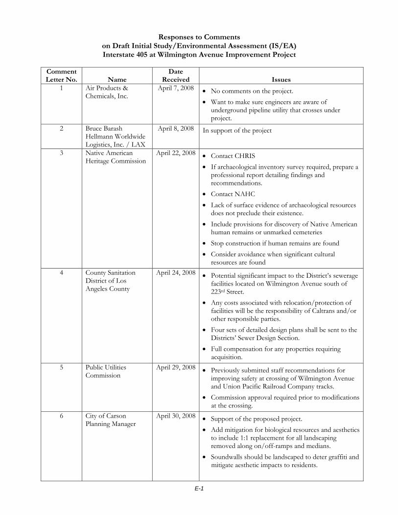
E-1
Responses to Comments on Draft Initial Study/Environmental Assessment (IS/EA) Interstate 405 at Wilmington Avenue Improvement Project
Comment Letter No. Name
Date Received Issues
1 Air Products & Chemicals, Inc.
April 7, 2008 • No comments on the project. • Want to make sure engineers are aware of
underground pipeline utility that crosses under project.
2 Bruce Barash Hellmann Worldwide Logistics, Inc. / LAX
April 8, 2008 In support of the project
3 Native American Heritage Commission
April 22, 2008 • Contact CHRIS • If archaeological inventory survey required, prepare a
professional report detailing findings and recommendations.
• Contact NAHC • Lack of surface evidence of archaeological resources
does not preclude their existence. • Include provisions for discovery of Native American
human remains or unmarked cemeteries • Stop construction if human remains are found • Consider avoidance when significant cultural
resources are found 4 County Sanitation
District of Los Angeles County
April 24, 2008 • Potential significant impact to the District’s sewerage facilities located on Wilmington Avenue south of 223rd Street.
• Any costs associated with relocation/protection of facilities will be the responsibility of Caltrans and/or other responsible parties.
• Four sets of detailed design plans shall be sent to the Districts’ Sewer Design Section.
• Full compensation for any properties requiring acquisition.
5 Public Utilities Commission
April 29, 2008 • Previously submitted staff recommendations for improving safety at crossing of Wilmington Avenue and Union Pacific Railroad Company tracks.
• Commission approval required prior to modifications at the crossing.
6 City of Carson Planning Manager
April 30, 2008 • Support of the proposed project. • Add mitigation for biological resources and aesthetics
to include 1:1 replacement for all landscaping removed along on/off-ramps and medians.
• Soundwalls should be landscaped to deter graffiti and mitigate aesthetic impacts to residents.
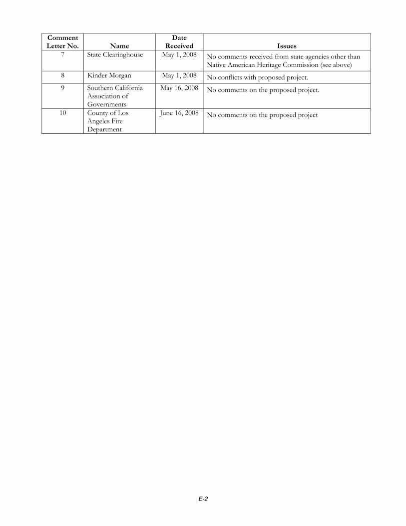
E-2
Comment Letter No. Name
Date Received Issues
7 State Clearinghouse May 1, 2008 No comments received from state agencies other than Native American Heritage Commission (see above)
8 Kinder Morgan May 1, 2008 No conflicts with proposed project. 9 Southern California
Association of Governments
May 16, 2008 No comments on the proposed project.
10 County of Los Angeles Fire Department
June 16, 2008 No comments on the proposed project

E-3
Response to Comment Letter No. 1 – Air Products & Chemicals, Inc. 1. The attached drawings were forwarded to the project engineer, who
was aware of the underground pipeline. It has been noted that Air Products has no environmental concerns for the project.
1
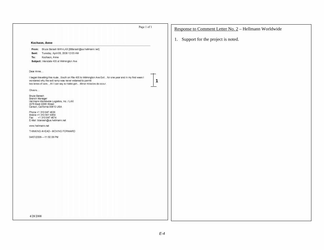
E-4
Response to Comment Letter No. 2 – Hellmann Worldwide 1. Support for the project is noted.
1
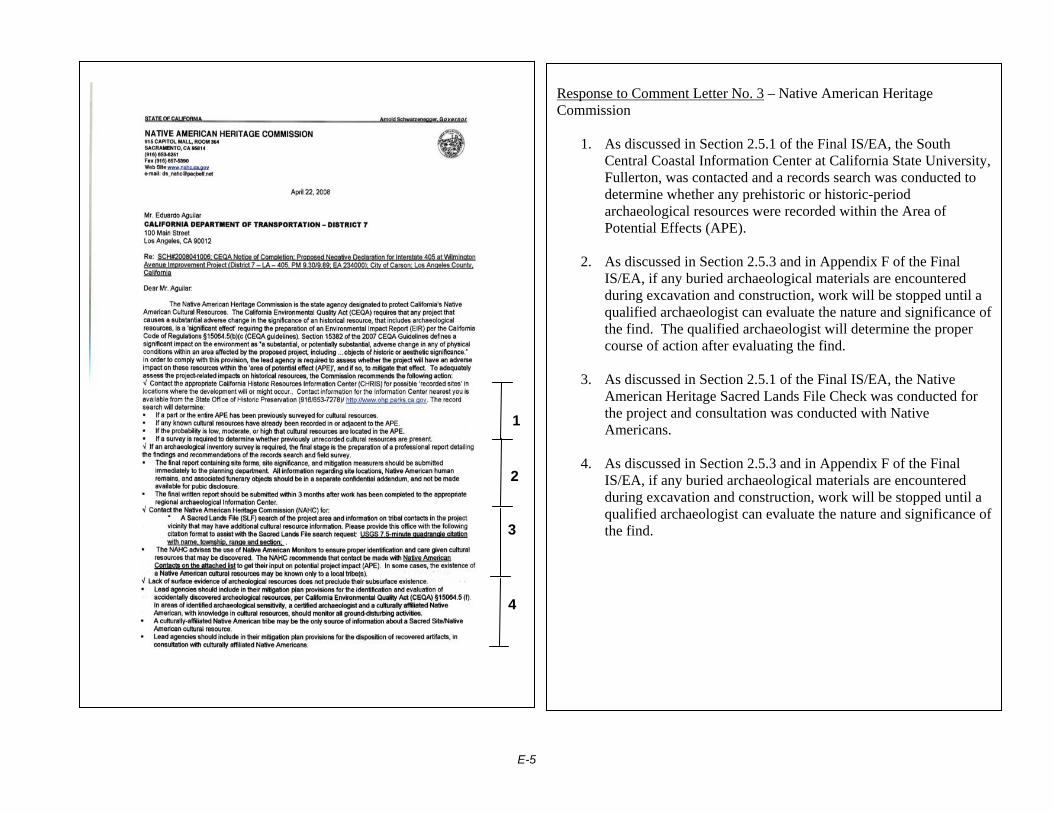
E-5
Response to Comment Letter No. 3 – Native American Heritage Commission
1. As discussed in Section 2.5.1 of the Final IS/EA, the South Central Coastal Information Center at California State University, Fullerton, was contacted and a records search was conducted to determine whether any prehistoric or historic-period archaeological resources were recorded within the Area of Potential Effects (APE).
2. As discussed in Section 2.5.3 and in Appendix F of the Final
IS/EA, if any buried archaeological materials are encountered during excavation and construction, work will be stopped until a qualified archaeologist can evaluate the nature and significance of the find. The qualified archaeologist will determine the proper course of action after evaluating the find.
3. As discussed in Section 2.5.1 of the Final IS/EA, the Native
American Heritage Sacred Lands File Check was conducted for the project and consultation was conducted with Native Americans.
4. As discussed in Section 2.5.3 and in Appendix F of the Final
IS/EA, if any buried archaeological materials are encountered during excavation and construction, work will be stopped until a qualified archaeologist can evaluate the nature and significance of the find.
1
2
3
4

E-6
Response to Comment Letter No. 3 – Native American Heritage Commission
5. Information was added to Section 2.5.3 and Appendix F of the Final IS/EA to include mitigation to stop work in the event that human remains, including human remains of Native American origin, are encountered during project construction.
6. Information was added to Section 2.5.3 and Appendix F of the Final IS/EA to include mitigation to stop work in the event that human remains, including human remains of Native American origin, are encountered during project construction.
7. Comment noted. As discussed in Section 2.5.2 of the Final
IS/EA, no significant cultural resources are anticipated within the project location.
6
7
5
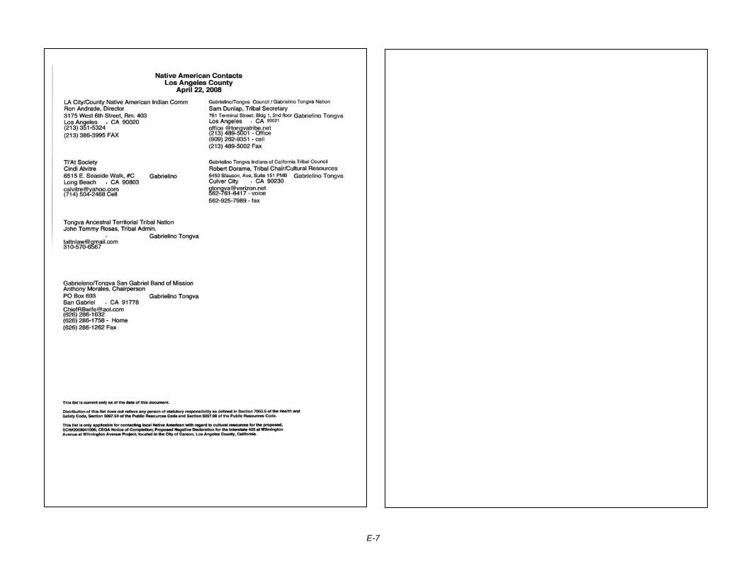
E-7
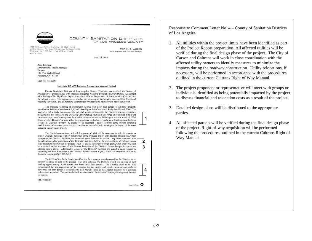
E-8
Response to Comment Letter No. 4 – County of Sanitation Districts of Los Angeles 1. All utilities within the project limits have been identified as part
of the Project Report preparation. All affected utilities will be verified during the final design phase of the project. The City of Carson and Caltrans will work in close coordination with the affected utility owners to identify measures to minimize the impacts during the roadway construction. Utility relocations, if necessary, will be performed in accordance with the procedures outlined in the current Caltrans Right of Way Manual.
2. The project proponent or representative will meet with groups or
individuals identified as being potentially impacted by the project to discuss financial and relocation costs as a result of the project.
3. Detailed design plans will be distributed to the appropriate
parties.
4. All affected parcels will be verified during the final design phase of the project. Right-of-way acquisition will be performed following the procedures outlined in the current Caltrans Right of Way Manual.
1
2 3
4

E-9

E-10
Response to Comment Letter No. 5 – Public Utilities Commission
1. The City of Carson and Caltrans acknowledge the receipt of the letter of recommendations dated June 18, 2007. The City of Carson and Caltrans will coordinate with the Public Utilities Commission concerning all applicable railroad safety components to address the need and mitigation measures to ensure smooth operation of the railroad.
2. The City of Carson will obtain all necessary agreement,
permit, and approval prior to commencement of construction activities within the railroad right of way.
1
2
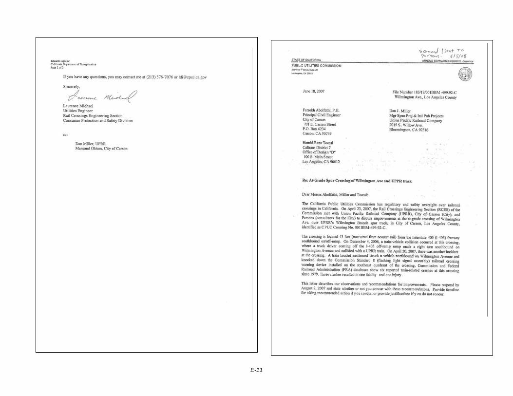
E-11

E-12

E-13

E-14

E-15
Response to Comment Letter No. 6 – City of Carson, Planning Manager 1. It is feasible to replace trees removed during construction along
the Wilmington on-ramp and proposed off-ramp at a 1:1 ratio. The City of Carson Public Works Department will determine the number of trees to be removed. The City will work with Caltrans to identify possible nearby locations within the Caltrans ROW where the replacement trees can be planted. Where feasible, remnant locations near the construction areas will be planted with trees in compliance with Caltrans setback requirements; the current 65% plans reflect this solution.
Landscape plans for the remnant areas have been prepared in coordination with Caltrans. It is feasible to prepare landscape plans that show any additional 1:1 replacement plantings not accommodated within the remnant areas. The City of Carson Public Works Department will work with the City of Carson Planning Department for appropriate approval of landscaping and visual aesthetics prior to construction.
1

E-16
Response to Comment Letter No. 6 – City of Carson, Planning Manager 2. It is not feasible to landscape the Wilmington medians within the
Caltrans ROW; they are too small to successfully accommodate planting. The existing medians within the Caltrans ROW are paved with stamped concrete and they will be repaved with stamped concrete after re-construction.
The landscaping for the impacted medians within the City of Carson ROW on both Wilmington and 223rd Street has been called out to be "repaired and replaced" to minimize the biological and aesthetic impacts of construction.
3. It is feasible to provide vines at the proposed soundwalls to deter
graffiti and mitigate aesthetic impacts; the current 65% plans reflect this solution. The City of Carson Public Works Department will work with the City of Carson Planning Department for appropriate approval of landscaping and visual aesthetics prior to construction.
1
2
3

E-17
Response to Comment Letter No. 7 – State Clearinghouse 1. The attached letter is the same letter received from the Native
American Heritage Commission. Please see Response to Comments for Letter No. 3 – Native American Heritage Commission for comment resolution.
1

E-18

E-19
Response to Comment Letter No. 8 – Kinder Morgan 1. It is noted that Kinder Morgan has no conflicts with the project.
1
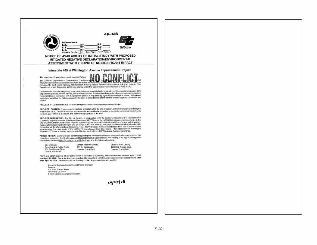
E-20

E-21
Response to Comment Letter No. 9 – Southern California Association of Governments 1. It is noted that the Southern California Association of
Governments has no comments on the proposed project.

E-22
Response to Comment Letter No. 10 – County of Los Angeles Fire Department 2. It is noted that the County of Los Angeles Fire Department has
no comments on the proposed project.

E-23

E-24

Appendix F Title VI Policy Statement

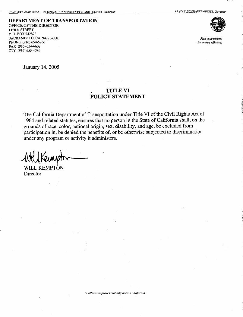


Appendix G Minimization and Mitigation Summary

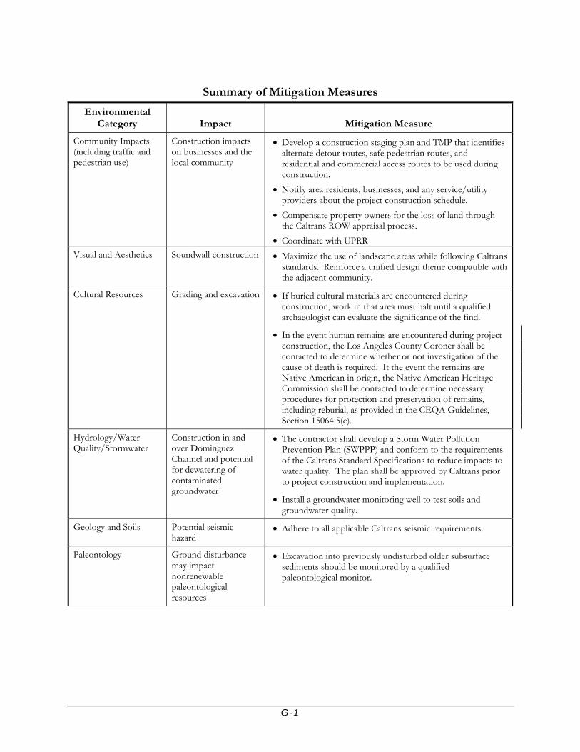
G-1
Summary of Mitigation Measures
Environmental Category Impact Mitigation Measure
Community Impacts (including traffic and pedestrian use)
Construction impacts on businesses and the local community
• Develop a construction staging plan and TMP that identifies alternate detour routes, safe pedestrian routes, and residential and commercial access routes to be used during construction.
• Notify area residents, businesses, and any service/utility providers about the project construction schedule.
• Compensate property owners for the loss of land through the Caltrans ROW appraisal process.
• Coordinate with UPRR Visual and Aesthetics
Soundwall construction • Maximize the use of landscape areas while following Caltrans standards. Reinforce a unified design theme compatible with the adjacent community.
Cultural Resources
Grading and excavation • If buried cultural materials are encountered during construction, work in that area must halt until a qualified archaeologist can evaluate the significance of the find.
• In the event human remains are encountered during project construction, the Los Angeles County Coroner shall be contacted to determine whether or not investigation of the cause of death is required. It the event the remains are Native American in origin, the Native American Heritage Commission shall be contacted to determine necessary procedures for protection and preservation of remains, including reburial, as provided in the CEQA Guidelines, Section 15064.5(e).
Hydrology/Water Quality/Stormwater
Construction in and over Dominguez Channel and potential for dewatering of contaminated groundwater
• The contractor shall develop a Storm Water Pollution Prevention Plan (SWPPP) and conform to the requirements of the Caltrans Standard Specifications to reduce impacts to water quality. The plan shall be approved by Caltrans prior to project construction and implementation.
• Install a groundwater monitoring well to test soils and groundwater quality.
Geology and Soils Potential seismic hazard
• Adhere to all applicable Caltrans seismic requirements.
Paleontology Ground disturbance may impact nonrenewable paleontological resources
• Excavation into previously undisturbed older subsurface sediments should be monitored by a qualified paleontological monitor.

G-2
Summary of Mitigation Measures
Environmental Category Impact Mitigation Measure
Hazardous Materials/ Waste
Potential for encountering soil contamination, ADL in soil, or LBP coatings
• All contaminated soils shall be treated in conformance with the California DTSC regulations
• Specifications for the removal of asbestos, suspected meals coated with lead-based paint, and other hazardous substances, if encountered during construction, shall be included in the project.
• All litter and solid waste will be taken to an approved disposal facility.
Air Quality
Particulate emissions from construction activities
• The project will be required to comply with regional SCAQMD rules, which would assist in reducing short-term air pollutant emissions.
• Construction equipment shall be properly tuned and maintained in accordance with manufacturer’s specifications.
• During construction, trucks and vehicles in loading and unloading queues must be kept with their engines off when not in use to reduce vehicle emissions.
• Construction emissions shall be phased and scheduled to avoid emissions peaks, where feasible, and discontinued during second-stage smog alerts
Noise Elevated noise during construction and traffic noise during operation
• The City of Carson will notify the area businesses and residents of the construction schedule at least two weeks in advance of the construction and provide a telephone hotline for any complaints.
• The construction schedule will be arranged so that the soundwalls would be completed before the NB on-ramp construction to minimize construction noise impacts to the residences north of I-405 from ramp construction.
• All equipment shall have sound-control devices no less effective than those provided on the original equipment. No equipment shall have an unmuffled exhaust.
• As directed by the Caltrans resident engineer, the contractor shall implement appropriate additional noise abatement measures.

G-3
Summary of Mitigation Measures
Environmental Category Impact Mitigation Measure
Biological Resources Tree removal impacts • When trees are removed, they will be replaced with trees of comparable size and canopy quality to attract nesting birds. Ground preparation and removal of any or all those trees should occur between September 1st and February 1st to minimize the chance of disturbing nesting birds protected by the Migratory Bird Treaty Act of 1918.
• If storm water BMPs are implemented at the interior of the NB loop-ramp area, the existing Cottonwood trees would be removed and replaced within the loop in commensurate numbers. Caltrans shall coordinate with the City of Carson to determine specific locations of replacement trees.

Appendix H Acronyms and Abbreviations


H-1
ACRONYMS AND ABBREVIATIONS
AB Assembly Bill ARB ADA
Air Resources Board Americans with Disabilities Act
ADAAG Americans with Disabilities Act Accessible Guidelines AADT average annual daily traffic ADL Aerially deposited Lead ADT average daily trips APCD Air Pollution Control District APE APN
area of potential effects assessor parcel number
AQMD Air Quality Management District AQMP ASR
Air Quality Management Plan Archaeology Survey Report
BMPs Best Management Practices BP British Petroleum bgs below ground surface CAA Clean Air Act CAAAs Clean Air Act Amendments CAAQS California ambient air quality standards CalEPA California Environmental Protection Agency Caltrans California Department of Transportation CARB California Air Resources Board CCAA California Clean Air Act CCR California Code of Regulations CDFG California Department of Fish and Game CEQ Council on Environmental Quality CEQA California Environmental Quality Act CERCLA Comprehensive Environmental Response, Compensation and
Liability Act CERFA CESA
Community Environmental Response Facilitation Act California Endangered Species Act
CFR Code of Federal Regulations CIA CISS
Community Impact Assessment Cast in steel shell
CMP Corrugated Metal Pipe CNDDB CNPS
California Department of Fish and Game Natural Diversity Database
California Native Plant Society CO carbon monoxide CWA Clean Water Act

H-2
CWC Clean Water Code dB Decibel dBA A-weighted decibel DDT Dichloro-diphenyl-trichloroethane DPM Diesel Particulate Matter DTSC Department of Toxic Substances Control EB Eastbound EIR Environmental Impact Report EIS Environmental Impact Statement EO Executive Order EPA United States Environmental Protection Agency FEMA FESA
Federal Emergency Management Agency Federal Endangered Species Act
FHWA FIFRA
Federal Highway Administration Federal Insecticide, Fungicide, and Rodenticide Act
FIRM Flood Insurance Rate Maps FONSI Findings of No Significant Impact FY Fiscal Year GHG Greenhouse Gas HAP Hazardous Air Pollutant HCM Highway Capacity Manual HOV High Occupancy Vehicle lane HHS HPSR
Department of Health and Human Services Historic Property Survey Report
Hz I-110
Hertz Interstate 110
I-405 I-710
Interstate 405 Interstate 710
IL Insertion Loss IPCC Intergovernmental Panel on Climate Change ISA Initial Site Assessment IS/EA ISTEA kHz
Initial Study/Environmental Assessment Intermodal Surface Transportation Efficiency Act kilohertz
LACDPW Los Angeles County Department of Public Works LACFD Los Angeles County Fire Department LARWQCB Los Angeles Regional Water Quality Control Board LBP Lead Based Paint Leq equivalent sound level Lmax maximum sound level LOS level of service Lp sound pressure level LUST Leaking underground storage tank Lx percentile-exceeded sound level

H-3
M MATES-II
Richter magnitude Multiple Air Toxics Exposure Study
mg/L milligrams per liter µg/m3 micrograms per cubic meter µN/m2
µPa Micro-Newton per square meter Micro-Pascal
MCE Maximum Credible Earthquake MEP Maximum Extent Practicable MLD Most Likely Descendant MND Mitigated Negative Declaration MPO Metropolitan Planning Organization MSAT Mobile Source Air Toxics MSL mean sea level MTA Metropolitan Transportation Authority Mw Maximum moment magnitude NAAQS National Ambient Air Quality Standards NAC noise abatement criterion NAHC Native American Heritage Commission NB Northbound NBSSR Noise Barrier Scope Summary Report NEPA National Environmental Policy Act NHPA National Historic Preservation Act NO2 nitrogen dioxide NOX NOA NOAA
nitrogen oxides Notice of Availability National Oceanic and Atmospheric Administration
NOIS Notice of Initiation of Studies NPDES National Pollutant Discharge Elimination System NRHP National Register of Historic Places O3 ozone OSHA Occupational Safety and Health Act PA Programmatic Agreement PAH Polycyclic Aromatic Hydrocarbons Pb Lead PM2.5 particulate matter of less than 2.5 microns in diameter PM10 particulate matter of less than 10 microns in diameter ppm parts per million POAQC Project of Air Quality Concern PRC RAP
Public Resources Code Relocation Assistance Program
RCP Reinforced concrete pipe RCRA Resource Conservation and Recovery Act ROW right-of-way RTIP (or TIP) Regional Transportation Improvement Program

H-4
RTP Regional Transportation Plan RWQCB Regional Water Quality Control Board SB Southbound SCAB South Coast Air Basin SCAG Southern California Association of Governments SCAQMD SHPO
South Coast Air Quality Management District State Historic Preservation Officer
SI Site Investigation SIP State Implementation Plan SFR Single Family Residence SO2 Sulfur dioxide SR State Route SRA Source/Receptor Area STIP State Transportation Improvement Program SWMP Storm Water Management Plan SWPPP Storm Water Pollution Prevention Permit SWRCB State Water Resources Control Board TAC toxic air contaminants TASAS Traffic Accident Surveillance and Analysis System TCM TDCs
Transportation Control Measures Targeted Design Constituents
TeNS TMDL
Technical Noise Supplement Total Maximum Daily Load
TMP Traffic Management Plan TNAP Traffic Noise Analysis Protocol TNM Traffic Noise Model TPH Total Petroleum Hydrocarbon TSAR TASAS Selective Accident Retrieval TSCA Toxic Substance Control Act TTLC Total Threshold Limit Concentration UPRR Union Pacific Railroad USACOE United States Army Corps of Engineers U.S.C. USFWS
United States Code United State Fish and Wildlife Service
USGS United States Geological Survey UST underground storage tank V/C volume to capacity ratio Vhp/lane Vehicle per hour per lane VMT vehicle miles traveled VOC Volatile organic compound
Appendix I Mitigation Monitoring and Reporting Program


Interstate 405 at Wilmington Avenue Improvement Project
Mitigation Monitoring and Reporting Program
Environmental Category
Measure Number Mitigation Measures
Timeframe for Implementation
Responsibility for Implementation
Oversight for Implementation
Community Impacts COM – 1 Develop a construction staging plan and Traffic management
Plan (TMP) that identifies alternate traffic detour routes, bus terminals, transit routes and operation hours, pedestrian routes, and residential and commercial access routes to be used during the construction.
Design Phase, Construction Phase
City of Carson and Caltrans
Caltrans
COM – 2 Notify area residents, businesses, and any service providers about the project construction schedule.
2-4 weeks before construction commencement
City of Carson and Caltrans
Caltrans
COM – 3
Compensate property owners for the loss of land through the Caltrans right of way (ROW) appraisal process.
Design Phase City of Carson and Caltrans
Caltrans
Community Impacts (including
Traffic and Pedestrian Use)
COM – 4
Coordinate with Union Pacific Railroad (UPRR) to avoid disruption of railroad activities.
Design Phase, Construction Phase
City of Carson and Caltrans
Caltrans
Visual & Aesthetics
Visual and Aesthetics
V/A – 1
Maximize the use of landscape areas while following Caltrans standards. Reinforce a unified design theme compatible with the adjacent community.
Design Phase City of Carson and Caltrans
Caltrans
Cultural Resources
Cultural Resources
CUL – 1
If buried cultural materials are encountered during construction work in that area must halt until a qualified archaeologist can evaluate the significance of the find.
Construction Phase Project Contractor Caltrans

Interstate 405 at Wilmington Avenue Improvement Project
Mitigation Monitoring and Reporting Program
Environmental Category
Measure Number Mitigation Measures
Timeframe for Implementation
Responsibility for Implementation
Oversight for Implementation
CUL – 2 In the event human remains are encountered during project construction, the Los Angeles County Coroner shall be contacted to determine whether or not investigation of the cause of death is required. It the event the remains are Native American in origin, the Native American Heritage Commission shall be contacted to determine necessary procedures for protection and preservation of remains, including reburial, as provided in the California Environmental Quality Act (CEQA) Guidelines, Section 15064.5(e).
Construction Phase Project Contractor Caltrans
Hydrology/Water Quality/Stormwater
WQ – 1 The contractor shall develop a Storm Water Pollution Prevention Plan (SWPPP) and conform to the requirements of the Caltrans Standard Specifications to reduce impacts to water quality. The plan shall be approved by Caltrans prior to project construction and implementation.
Design Phase, Construction Phase
Project Contractor Caltrans Hydrology/Water Quality/Stormwater
WQ – 2
Install a groundwater monitoring well to test soils and groundwater quality.
Design Phase, Construction Phase
Project Contractor Caltrans
Geology & Soils
Geology and Soils GEO – 1 Adhere to all applicable Caltrans seismic requirements. Design Phase, Construction Phase
Project Contractor Caltrans
Paleontology
Paleontology PAL – 1 Excavation into previously undisturbed older subsurface sediments should be monitored by a qualified paleontological monitor.
Construction Phase Project Contractor Caltrans
Hazardous Materials / Waste
Hazardous Materials/ Waste
HAZ – 1 All contaminated soils shall be treated in conformance with the California Department of Toxic Substances Control (DTSC) regulations.
Construction Phase Project Contractor Caltrans

Interstate 405 at Wilmington Avenue Improvement Project
Mitigation Monitoring and Reporting Program
Environmental Category
Measure Number Mitigation Measures
Timeframe for Implementation
Responsibility for Implementation
Oversight for Implementation
HAZ – 2 Specifications for the removal of asbestos, suspected meals coated with lead-based paint, and other hazardous substances, if encountered during construction, shall be included in the project.
Design Phase, Construction Phase
Project Contractor Caltrans
HAZ – 3 All litter and solid waste will be taken to an approved disposal facility.
Construction Phase Project Contractor Caltrans
Air Quality
AQ – 1 The project will be required to comply with regional South Coast Air Quality Management District (SCAQMD) rules, which would assist in reducing short-term air pollutant emissions.
Construction Phase Project Contractor Caltrans
AQ – 2 Construction equipment shall be properly tuned and maintained in accordance with manufacturer’s specifications.
Construction Phase Project Contractor Caltrans
AQ – 3 During construction, trucks and vehicles in loading and unloading queues must be kept with their engines off when not in use to reduce vehicle emissions.
Construction Phase Project Contractor Caltrans
Air Quality
AQ – 4 Construction emissions shall be phased and scheduled to avoid emissions peaks, where feasible, and discontinued during second-stage smog alerts.
Construction Phase Project Contractor Caltrans
Noise
N – 1 The City of Carson will notify the area businesses and residents of the construction schedule at least two weeks in advance of the construction and provide a telephone hotline for any complaints.
2-4 weeks before construction commencement
City of Carson and Caltrans
Caltrans
N – 2 The construction schedule will be arranged so that the soundwalls would be completed before the northbound on-ramp construction to minimize construction noise impacts to the residences north of I-405 from ramp construction.
Construction Phase City of Carson and Caltrans
Caltrans
Noise
N – 3 All equipment shall have sound-control devices no less effective than those provided on the original equipment. No equipment shall have an unmuffled exhaust.
Construction Phase Project Contractor Caltrans
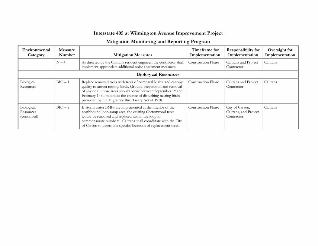
Interstate 405 at Wilmington Avenue Improvement Project
Mitigation Monitoring and Reporting Program
Environmental Category
Measure Number Mitigation Measures
Timeframe for Implementation
Responsibility for Implementation
Oversight for Implementation
N – 4 As directed by the Caltrans resident engineer, the contractor shall implement appropriate additional noise abatement measures.
Construction Phase Caltrans and Project Contractor
Caltrans
Biological Resources
Biological Resources
BIO – 1 Replace removed trees with trees of comparable size and canopy quality to attract nesting birds. Ground preparation and removal of any or all those trees should occur between September 1st and February 1st to minimize the chance of disturbing nesting birds protected by the Migratory Bird Treaty Act of 1918.
Construction Phase Caltrans and Project Contractor
Caltrans
Biological Resources (continued)
BIO – 2 If storm water BMPs are implemented at the interior of the northbound loop-ramp area, the existing Cottonwood trees would be removed and replaced within the loop in commensurate numbers. Caltrans shall coordinate with the City of Carson to determine specific locations of replacement trees.
Construction Phase City of Carson, Caltrans, and Project Contractor
Caltrans

Appendix J FHWA Air Quality Conformity Determination


7.0 U.S. DEPARTMENT OF TRANSPORTATION
FEDERAL HIGHWAY ADMINISTRATION CALIFORNIA DIVISION
650 Capitol Mall, Suite 4-100 Sacramento, CA. 95814 October 7, 2008
IN REPLY REFER TO
HDA-CA EA # 23400
Document # P58719 Doug Failing, District Director California Department of Transportation District 7 100 South Main Street, Suite 100 Los Angeles, CA 90012-3606 Attention: Andrew Yoon, Senior Transportation Engineer Dear Mr. Failing: SUBJECT: Project-Level Conformity Determination for I-405/Wilmington Interchange
Improvement Project On September 9, 2008, the California Department of Transportation (Caltrans) submitted to the Federal Highway Administration (FHWA) a request for the project-level conformity determination for the Interstate 405, Wilmington Interchange Improvement Project pursuant to 23 U.S.C. 327(a)(2)(B)(ii)(1). The project is in an area that is designated Nonattainment for 8-Hour Ozone, Particulate Matter (PM10), and Fine Particle Particulate Matter (PM 2.5) and Maintenance for Carbon Monoxide (CO). The project-level air quality conformity analysis submitted by Caltrans indicates that the transportation conformity requirements of 40 C.F.R. Part 93 have been met. The project is included in the Southern California Association of Government’s (SCAG) currently conforming 2008 Regional Transportation Plan (RTP), and the 2006 Regional Transportation Improvement Program (RTIP). The current conformity determinations for the RTP and RTIP were approved by FHWA and the Federal Transit Administration (FTA) on June 5, 2008. The design concept and scope of the preferred alternative have not changed significantly from those assumed in the regional emissions analysis. As required by 40 C.F.R. 93.116 and 93.123, the localized CO, PM10, and PM2.5 analyses are included in the documentation. The CO hotspot analysis was performed with the Caltrans’ Transportation Project-Level Carbon Monoxide Protocol. The analyses demonstrate that the project will not create any new violation of the standards or increase the severity or number of existing violations.

Based on the information provided, FHWA finds that the Conformity Determination for the I-405, Wilmington Interchange Improvement Project conforms to the State Implementation Plan (SIP) in accordance with 40 C.F.R. Part 93. If you have any questions pertaining to this conformity finding, please contact Aimee Kratovil, FHWA Air Quality Specialist, at (916) 498-5866. Sincerely, /s/ K. Sue Kiser For Gene K. Fong Division Administrator cc: (email) Eduardo Aguilar, Caltrans Mike Brady, Caltrans Steve Luxenberg, FHWA AKratovil/ac