Embed Size (px)
Citation preview

U.S. Army Corps of Engineers New York District
SOUTH SHORE OF STATEN ISLAND COASTAL STORM RISK MANAGEMENT PROJECT
APPENDIX VII
REAL ESTATE PLAN
JUNE 2015
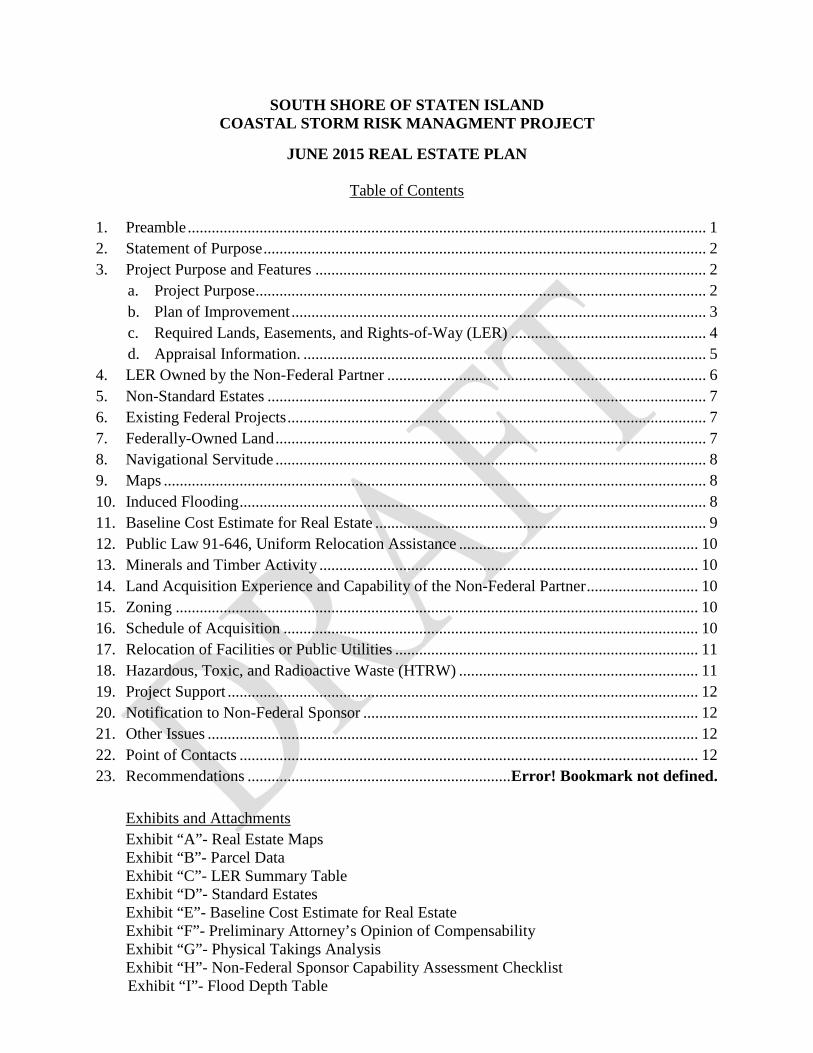
SOUTH SHORE OF STATEN ISLAND COASTAL STORM RISK MANAGMENT PROJECT
JUNE 2015 REAL ESTATE PLAN
Table of Contents
1. Preamble .................................................................................................................................. 1 2. Statement of Purpose ............................................................................................................... 2 3. Project Purpose and Features .................................................................................................. 2
a. Project Purpose ................................................................................................................. 2 b. Plan of Improvement ........................................................................................................ 3 c. Required Lands, Easements, and Rights-of-Way (LER) ................................................. 4 d. Appraisal Information. ..................................................................................................... 5
4. LER Owned by the Non-Federal Partner ................................................................................ 6 5. Non-Standard Estates .............................................................................................................. 7 6. Existing Federal Projects ......................................................................................................... 7 7. Federally-Owned Land ............................................................................................................ 7 8. Navigational Servitude ............................................................................................................ 8 9. Maps ........................................................................................................................................ 8 10. Induced Flooding ..................................................................................................................... 8 11. Baseline Cost Estimate for Real Estate ................................................................................... 9 12. Public Law 91-646, Uniform Relocation Assistance ............................................................ 10 13. Minerals and Timber Activity ............................................................................................... 10 14. Land Acquisition Experience and Capability of the Non-Federal Partner ............................ 10 15. Zoning ................................................................................................................................... 10 16. Schedule of Acquisition ........................................................................................................ 10 17. Relocation of Facilities or Public Utilities ............................................................................ 11 18. Hazardous, Toxic, and Radioactive Waste (HTRW) ............................................................ 11 19. Project Support ...................................................................................................................... 12 20. Notification to Non-Federal Sponsor .................................................................................... 12 21. Other Issues ........................................................................................................................... 12 22. Point of Contacts ................................................................................................................... 12 23. Recommendations .................................................................. Error! Bookmark not defined.
Exhibits and Attachments Exhibit “A”- Real Estate Maps Exhibit “B”- Parcel Data Exhibit “C”- LER Summary Table Exhibit “D”- Standard Estates Exhibit “E”- Baseline Cost Estimate for Real Estate Exhibit “F”- Preliminary Attorney’s Opinion of Compensability Exhibit “G”- Physical Takings Analysis Exhibit “H”- Non-Federal Sponsor Capability Assessment Checklist
Exhibit “I”- Flood Depth Table
-1-
1. Preamble
a. Project Authorization: A cooperative beach erosion and storm damage reduction study was authorized by a resolution of the U.S. House of Representatives Committee on Public Works and Transportation and adopted 13 May 1993. The resolution states:
“The Secretary of the Army, acting through the Chief of Engineers, is requested to review the report of the Chief of Engineers, on the Staten Island Coast from Fort Wadsworth to Arthur Kill, New York, published as House Document 181, Eighty- ninth Congress, First Session, and other pertinent reports, to determine whether modifications of the recommendations contained therein are advisable at the present time, in the interest of beach erosion control, storm damage reduction and related purposes on the South Shore of Staten Island, New York, particularly in and adjacent to the communities of New Dorp Beach, Oakwood Beach, and Annadale Beach, New York.”
The Disaster Relief Appropriations Act of 2013, Public Law 113-2, enacted on 29 January 2013 (hereinafter “P.L. 113-2”) authorizes the Secretary of the Army to utilize funds provided in P.L. 113-2, to complete construction of certain authorized but unconstructed projects, which includes the construction of this project. If authorized, the construction of this project will be cost-shared with the non-Federal Sponsor utilizing funds provided in P.L. 113-2.
Previous authorized studies and Federal projects include:
(1) Federal projects in 1937 provided beachfill, timber and rock groins, and a
timber bulkhead along the study area. (2) A project by the City and State of New York and unknown private entities in
1955 provided beachfill between New Creek and Miller Field. (3) A cooperative beach erosion control study, in accordance with Section 2 of
Public Law 520 (Rivers and Harbor Act of 1930), on 23 March 1959, for the study of the Atlantic Coast of Nassau County, New York, between Jones Inlet and East Rockaway Inlet; Atlantic Coast of New York City, between East Rockaway Inlet and Norton Point; and Staten Island, New York, between Fort Wadsworth and Arthur Kill.
(4) A hurricane study authorized by Public Law 71, 84th Congress, 1st Session
on June 15, 1955. A combined report covering the cooperative beach erosion control study and the hurricane survey was approved by the Chief of Engineers on 7 December 1960.
(5) An authorized Federal project under the Flood Control Act of 25 October
1965, spanning from Fort Wadsworth to Arthur Kill, Staten Island, New York. The authorized project was not constructed due to a lack of non-federal financing.
(6) An authorized Federal project under House Document No. 181, 189th
Congress, 1st Session for shore and hurricane protection between Fort Wadsworth and Oakwood
-2-
Beaches. Preconstruction planning for the project was initiated in January 1966 and was brought 60 percent completion.
(7) A General Design Memorandum for Fort Wadsworth to Oakwood Beach was
completed in June 1976. Work was suspended at the request of local authorities and in 1977, the New York State Department of Environmental Conservation defer their decision on local cooperation due to fiscal constraints.
(8) A Reconnaissance Study in June 1995 concluded Federal interest in finding
solutions to causative agents of ongoing erosion. Alternative solutions redefined the project area to a 6.5 mile portion of the State Island Shoreline from Fort Wadsworth to Oakwood Beach and Annadale Beach.
(9) Under the Section 103 Continuing Authority Program, the Corps of Engineers
constructed flood risk management project in 1999 in the Oakwood Beach area.
b. Official Project Designation: South Shore of Staten Island Coastal Storm Risk Management (hereinafter the “Project”).
c. Project Location: The Project extends approximately three square miles from Fort
Wadsworth to Oakwood Beach along the northern end of the south shoreline of Staten Island in Richmond County, New York.
d. Non-Federal Partner: The non-Federal partner for this Project is the New York State
Department of Environmental Conservation (the “Sponsor” or “NYDEC”), who subsequently entered into a partnering agreement with the New York City Department of Environmental Protection (“NYCDEP”) as the local stakeholder. 2. Statement of Purpose
The purpose of this Real Estate Plan (the “REP”) is to present the overall plan describing the minimum real estate required for the construction, operation, maintenance, repair and rehabilitation of the proposed Project. This REP is an appendix to the Project’s Hurricane Sandy Feasibility Report (the “Feasibility Report”). 3. Project Purpose and Features
a. Project Purpose: The purpose of the Project is to provide coastal storm risk
management to flood-prone, high risk low-lying residential and commercial structures along the south shore of Staten Island between Oakwood Beach and Fort Wadsworth. This area was devastated by Hurricane Sandy on 29 October 2012 with recorded water surface elevation above sixteen feet National Geodetic Vertical Datum of 1929 (NGVD 1929), (Colleen Fanelli, 2013), and with waves up to six feet in height (Perkins Eastman, BFJ Planning, Louis Berger Group, 2014). The storm caused extensive damage and loss of life along the study area. If approved, the Project will reduce the risk of damages from hurricane and storm surge flooding along the study area, reduce the risk to local resident’s life and safety, and would be consistent with and

-3-
complementary to the New York City Bluebelt Program. The Bluebelt Program is the City of New York’s stormwater management program that preserves natural drainage corridors for conveying, storing, and filtering stormwater.
The Project is currently in the feasibility phase and the Feasibility Report is scheduled for
approval by the Assistant Secretary of the Army in April 2016. A Project Partnership Agreement (PPA) is scheduled to be executed in June 2016.
b. Plan of Improvement: The plan of improvement provides for coastal storm risk
management in the form of a structural Line of Protection (LOP) consisting of a levee system and interior drainage facilities, which are described below.
I. Line of Protection: The Project will include an approximately 2.5-mile LOP,
which consists of buried seawall/armored levee (with raised promenade) with an average crest elevation of 20.5 feet NGVD 1929 (hereinafter referred to as “Line of Protection” or “LOP”). The LOP will serve as the first line of defense against severe coastal surge flooding and wave forces. The remainder of the LOP consists of T-Type vertical floodwalls and earthen levees. The LOP also includes a stop log closure structure at Hylan Boulevard, drainage control structures for existing storm water outfalls, tide gate structures, vehicle and pedestrian access structures, and demolition of an existing boardwalk.
II. Interior Drainage: The Project will also include interior drainage facilities.
The interior drainage plan is segregated by drainage area:
a) Oakwood Beach Interior Drainage Area (Area A) b) Oakwood Beach Interior Drainage Area (Area B) c) Midland Beach Interior Drainage Area (Area C) d) South Beach Interior Drainage Area (Area D) e) South Beach Interior Drainage Area (Area E)
Minimum Facility Plans for Drainage Areas A, B, and D include tide gates, sluice gates, road raisings, natural storage ponds, and excavated ponds. The plans for Areas C and E include tide gates, sluice gates, road raises, and networks of excavated ponds to a depth of approximately 2 feet NGVD 1929. Where possible, the interior drainage plan has been aligned and overlapped with Bluebelt.
III. Construction Contracts: The Project is proposed to be implemented through
two separate contracts:
1. Contract 1 consists of Interior Drainage Areas A and B and the LOP beginning at the vicinity of Hyland Blvd and Buffalo Street and ending at the vicinity of New Dorp Lane by Miller Field (“LOP-1”). Contract award is scheduled for December 2016 and the anticipated construction period is from December 2016 to April 2019.
2. Contract 2 consists of Interior Drainage Areas C, D, and E and the LOP
beginning at the vicinity of New Dorp Lane and ending at the vicinity of Ayers Road near Fort

-4-
Wadsworth (“LOP-2”). Contract award is scheduled for November 2017 and the anticipated construction period is from November 2017 to November 2020.
c. Required Lands, Easements, and Rights-of-Way (LER): The Sponsor has entered into
a partnering agreement with NYCDEP, where NYCDEP will acquire the real estate interests needed for the construction of the proposed Project. The Sponsor will obtain the required easements in the form of Access Agreements from NYCDEP containing the required standard estates language and necessary covenants to run with the land therein. Access Agreements are in recordable form and will be required to be recorded with the county.
The following chart provides the approximate aggregated acres required for the Project:
Permanent Easements………………….. ±345.01 acres Temporary Easements…………………. ±62.59 acres
Total: ±407.40acres The Project impacts 666 parcels, affecting 270 private owners and 396 public owners
(including two Federal agencies). In some instances, more than one estate is required to be obtained over the lands of the same owner.
I. Flowage Easement (Portions of Land to be Subjected to Permanent Inundation
and Portions to be Subjected to Occasional Flooding) (Standard Estate No. 7): Approximately 112.08 acres are required for the excavation of 10 ponds to provide a greater volume for residual storm water retention during high intensity precipitation storm events. No disposal sites are required to be provided for the Project. The selected contractor will be responsible for the transportation and disposal of the excavated material to an approved disposal site.
II. Flood Protection Levee Easement (Standard Estate No. 9): Approximately 87.62 acres are required for the construction, operation, and maintenance of the buried seawall/armored levee.
III. Pipeline Easement (Standard Estate No. 13): Approximately 0.09 of an acre
is required for the construction, operation and maintenance of an underground storm water drainage structure. The drainage structure will allow storm water to flow from the open space south of Kissam Avenue into the proposed ponding area located north of Kissam Avenue.
IV. Road Easement (Standard Estate No. 13): Approximately 1.14 acres are required for the construction of an access road to provide access to sewer manhole that will be raised along the LOP in the vicinity of Interior Drainage Area B.
V. Restrictive Easement (Standard Estate No. 19): Approximately 143.84 acres
are required to protect against future development to preserve open space for flooding, which is essential to the effectiveness of the proposed ponding areas.

-5-
VI. Temporary Work Area Easement (Standard Estate No. 15): Approximately 62.62 acres are required for staging/work area purposes. The required temporary work areas are typically adjacent to land to be acquired for construction of the LOP and typically affect the same ownerships. Temporary work area easements will be required for the duration of the construction contracts identified in paragraph 3.b.III.
VII. LER Summary: A summary of the required LER is provided in Exhibit “C”.
Impacted parcels and the real estate interested required therein is provided in Exhibit “B”. The recommended standard estates are provided in Exhibit “D”. The size of the real estate interests required for the Project as identified in this REP are estimates based on available Geographic Information System (GIS) data. The Sponsor will be advised to obtain a survey and legal description for each permanent easement acquired to determine its precise size and boundary limits within it respective parcel. The Sponsor will also be advised to obtain title insurance on all acquiring property to protect against “defects” in title and to identify potential encumbrances that could impact project construction. The Sponsor will be required to record all easements with the county prior to the U.S. Army Corps of Engineers’ certification of real estate.
d. Appraisal Information: An appraisal cost estimate was completed in September 2014 and updated in May 2015. The total estimated land value for the required real estate is$25,467,497, effective 18 May 2015.
Project Area Permanent Easement Temporary Easement Totals
Con
tract
1
Drainage Area A
$2,229,294
$0 $2,229,294 Drainage Area B $3,099,416 $0 $3,099,416 LOP-1 $3,954,544 $8,405 $3,962,949
Con
tract
2
Drainage Area C
$5,300,503
$0 $5,300,503 Drainage Area D $7,509,986 $0 $7,509,986 Drainage Area E $3,028,612 $0 $3,028,612 LOP-2 $316,392 $20,345 $336,737
Total Values $25,438,747 $28,750 $25,467,497 The valuation was completed based upon a hypothetical condition. The subject
properties may become encumbered by easements required for the proposed Project creating an easement estate for flood control purposes. The easements did not exist as of the date of the cost estimate. Therefore, an assumption was made that the easements will be executed within a reasonable time not to exceed one year from the effective date of the cost estimate. The cost estimate was completed based on the wetland and upland nature of parcels as provided by GIS data. A full land valuation based on surveyed boundaries would be required to establish a more accurate valuation.
-6-
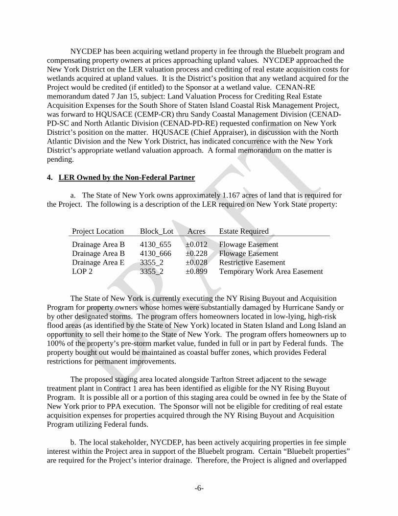
NYCDEP has been acquiring wetland property in fee through the Bluebelt program and compensating property owners at prices approaching upland values. NYCDEP approached the New York District on the LER valuation process and crediting of real estate acquisition costs for wetlands acquired at upland values. It is the District’s position that any wetland acquired for the Project would be credited (if entitled) to the Sponsor at a wetland value. CENAN-RE memorandum dated 7 Jan 15, subject: Land Valuation Process for Crediting Real Estate Acquisition Expenses for the South Shore of Staten Island Coastal Risk Management Project, was forward to HQUSACE (CEMP-CR) thru Sandy Coastal Management Division (CENAD-PD-SC and North Atlantic Division (CENAD-PD-RE) requested confirmation on New York District’s position on the matter. HQUSACE (Chief Appraiser), in discussion with the North Atlantic Division and the New York District, has indicated concurrence with the New York District’s appropriate wetland valuation approach. A formal memorandum on the matter is pending.
4. LER Owned by the Non-Federal Partner
a. The State of New York owns approximately 1.167 acres of land that is required for the Project. The following is a description of the LER required on New York State property:
Project Location Block_Lot Acres Estate Required
Drainage Area B 4130_655 ±0.012 Flowage Easement Drainage Area B 4130_666 ±0.228 Flowage Easement Drainage Area E 3355_2 ±0.028 Restrictive Easement LOP 2 3355_2 ±0.899 Temporary Work Area Easement
The State of New York is currently executing the NY Rising Buyout and Acquisition Program for property owners whose homes were substantially damaged by Hurricane Sandy or by other designated storms. The program offers homeowners located in low-lying, high-risk flood areas (as identified by the State of New York) located in Staten Island and Long Island an opportunity to sell their home to the State of New York. The program offers homeowners up to 100% of the property’s pre-storm market value, funded in full or in part by Federal funds. The property bought out would be maintained as coastal buffer zones, which provides Federal restrictions for permanent improvements. The proposed staging area located alongside Tarlton Street adjacent to the sewage treatment plant in Contract 1 area has been identified as eligible for the NY Rising Buyout Program. It is possible all or a portion of this staging area could be owned in fee by the State of New York prior to PPA execution. The Sponsor will not be eligible for crediting of real estate acquisition expenses for properties acquired through the NY Rising Buyout and Acquisition Program utilizing Federal funds.
b. The local stakeholder, NYCDEP, has been actively acquiring properties in fee simple interest within the Project area in support of the Bluebelt program. Certain “Bluebelt properties” are required for the Project’s interior drainage. Therefore, the Project is aligned and overlapped
-7-
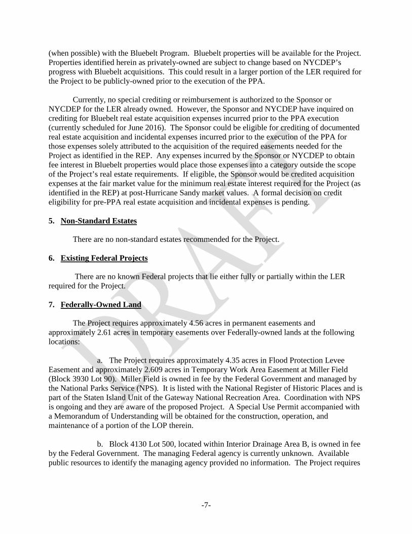
(when possible) with the Bluebelt Program. Bluebelt properties will be available for the Project. Properties identified herein as privately-owned are subject to change based on NYCDEP’s progress with Bluebelt acquisitions. This could result in a larger portion of the LER required for the Project to be publicly-owned prior to the execution of the PPA. Currently, no special crediting or reimbursement is authorized to the Sponsor or NYCDEP for the LER already owned. However, the Sponsor and NYCDEP have inquired on crediting for Bluebelt real estate acquisition expenses incurred prior to the PPA execution (currently scheduled for June 2016). The Sponsor could be eligible for crediting of documented real estate acquisition and incidental expenses incurred prior to the execution of the PPA for those expenses solely attributed to the acquisition of the required easements needed for the Project as identified in the REP. Any expenses incurred by the Sponsor or NYCDEP to obtain fee interest in Bluebelt properties would place those expenses into a category outside the scope of the Project’s real estate requirements. If eligible, the Sponsor would be credited acquisition expenses at the fair market value for the minimum real estate interest required for the Project (as identified in the REP) at post-Hurricane Sandy market values. A formal decision on credit eligibility for pre-PPA real estate acquisition and incidental expenses is pending. 5. Non-Standard Estates
There are no non-standard estates recommended for the Project. 6. Existing Federal Projects There are no known Federal projects that lie either fully or partially within the LER required for the Project. 7. Federally-Owned Land The Project requires approximately 4.56 acres in permanent easements and approximately 2.61 acres in temporary easements over Federally-owned lands at the following locations:
a. The Project requires approximately 4.35 acres in Flood Protection Levee Easement and approximately 2.609 acres in Temporary Work Area Easement at Miller Field (Block 3930 Lot 90). Miller Field is owned in fee by the Federal Government and managed by the National Parks Service (NPS). It is listed with the National Register of Historic Places and is part of the Staten Island Unit of the Gateway National Recreation Area. Coordination with NPS is ongoing and they are aware of the proposed Project. A Special Use Permit accompanied with a Memorandum of Understanding will be obtained for the construction, operation, and maintenance of a portion of the LOP therein.
b. Block 4130 Lot 500, located within Interior Drainage Area B, is owned in fee by the Federal Government. The managing Federal agency is currently unknown. Available public resources to identify the managing agency provided no information. The Project requires

-8-
approximately 0.202 of an acre of land in Flowage Easement and approximately 0.009 of an acre of land in Restrictive Easement therein. Efforts are on-going to identify the managing agency. The use of Special Use Permits has been typical in obtaining rights in and upon Federally-owned lands managed by other Federal agencies. A Special Use Permit will be utilized for the purposes described above. Most recent, a Special Use Permit was granted by NPS for the construction of a berm on Fire Island National Sea Shore in support of the Fire Island to Moriches Inlet Project. 8. Navigational Servitude There is no LER required for the Project located below the mean high water line. Navigational Servitude is not applicable to the Project. 9. Maps The Project’s preliminary real estate maps are provided in Attachment “A”. 10. Induced Flooding
The Project provides the construction of 10 ponds across Interior Drainage Areas B, C, and E. Changes in flood depth for each of the proposed excavated ponds are identified in Table 10 of the Project’s Interior Drainage Analysis (Appendix II), which is provided in Exhibit “I” herein. Further analysis has been requested to determine duration and volume of the ponding areas. Based upon the available data, a Physical Taking Analysis (Exhibit “G”) prepared by the District’s Office of Counsel concluded that the current Draft Study for the Project does not appear to require use of a standard flowage easement. However, the District’s Real Estate Division believes that the standard flowage easement would be appropriate for East Pond located in Interior Drainage Area B and that further analysis and consideration is needed for the ponds in Interior Drainage Areas C and E. Since there is not concurrence on this issue at the time of the release of the Draft Interim Feasibility Report, the Office of Counsel and Real Estate Division will continue to coordinate on this issue and resolve prior to release of the Final Report, which will contain a final Physical Takings Analysis. While the LOP serves as a defense against severe coastal surge flooding and wave forces, the incidental effect of the LOP causes retention of precipitation from storm events at certain reaches along the levee by preventing the natural seaward drainage of storm water. Flooding in the area is driven by two distinct causes. The greatest risk is from storm surge, which creates widespread flooding with depths reaching 12 feet in some areas. The construction of the proposed armored levee and wall will reduce the storm surge for all but the largest events that would exceed the proposed LOP design. With the reduction of risk from storm surge, however, the risk of flooding from interior drainage becomes more important. Interior drainage features to address the interior flood risk are integral to the Project. As noted in paragraph 6-5, Engineering Manual 1110-2-1413, Hydrologic Analysis of Interior Area, 15 Jan 87:

-9-
“The capability of an interior flood loss reduction system to function over the project life must be assured. This often requires legally binding commitments from the local sponsors of the project to properly operate and maintain the system. Real estate interest required and specifications for operating and maintaining detention storage areas, pumping facilities, and conveyance networks, should be integral to all agreements for implementation of interior system of flood loss mitigation measures.”
Based upon the above statement, acquisition of land is an essential part of the natural storage needed for interior drainage behind the proposed LOP. In discussion with the Project Delivery Team, the Real Estate Division has concluded that the use of flowage and restrictive easements are warranted over the ponds in the interior drainage areas. The levee would prevent the natural seaward flow of storm water and create pooling of water along certain reaches of the LOP. Flowage easements will be utilized for the proposed excavated ponds to contain the increased residual flooding, while restrictive easements would prevent development to preserve open space to ensure land is available for flooding caused by storm events. Development of the open space would result in significant increase flooding caused by storm water runoff and undermine the Project, preventing it from achieving is stated flood reduction benefits. 11. Baseline Cost Estimate for Real Estate (BCERE) An itemized BCERE is provided in Exhibit “E” in Micro-Computer Aided Cost Estimating System (MCACES) format with estimated real estate costs. The following is a summary of the Project’s estimated Lands, Easements, Rights-of-Way, Relocations, and Disposals (LERRD) costs:
Cost Type Contract 1 Contract 2 Subtotal (rounded)
Contingency (39.3%)
Total
LER. $10,875,319 $18,952,578 $29,828,000 11,710,000 $41,538,000 Relocations $1,659,000 $30,567,000 $32,226,000 12,677,00 $44,903,000 Disposals $0 $0 $0 $0 $0
Subtotal: $62,054,000 Total: $86,441,000 The Project’s total estimated 01-Lands & Damages expense is $86,441,000. If approved, the Project will be cost-shared (65% Federal and 35% Non-Federal) utilizing funds provided in P.L. 113-2. The Sponsor will be entitled to LERRD credit toward the final cost of the Project at the cost-shared amount. The contingency is established by the Project’s Cost and Schedule Risk Analysis (CSRA) as provided in the Projects Cost Appendix (Appendix IV).
-10-
12. Public Law 91-646, Uniform Relocation Assistance No relocation assistance in accordance with Public Law 91-646 is anticipated to be required for the Project. 13. Minerals and Timber Activity There are no present or anticipated mineral activities or timber harvesting within the LER required for the Project. 14. Land Acquisition Experience and Capability of the Non-Federal Partner The Non-Federal Partner’s Capability Assessment Checklist is provided in Exhibit “H” herein. The Sponsor maintains the legal and professional capability and experience to acquire the LER for the construction, operation, and maintenance of the Project. The Sponsor has condemnation authority and other applicable authorities that may apply, if necessary, to support acquisition measures. However, it is not anticipated that these actions will be required or used for the Project. Recently, the Sponsor has successfully acquired the real estate for the for the Atlantic Coast of New York City Rockaway Inlet to Norton Point (Sea Gate Area of Coney Island) Shore Protection Project and is currently in the process of acquiring the real estate for the Fire Island Inlet to Moriches Inlet Stabilization Project. Although not anticipated for the Project, the Sponsor is aware of Public Law 91-646 requirements. The Sponsor is also aware of the requirements to document acquisition and incidental expenses associated with acquiring the LER for the Project for crediting purposes. 15. Zoning No application or enactment of local zoning ordinances is anticipated in lieu of, or to facilitate, the acquisition of LER in connection with the Project.
16. Schedule of Acquisition
Milestone Date
PPA Execution---------------------------------------------------------- Jun 2016 Sponsor’s Notice to Proceed with Acquisition---------------------- Jun 2016 Contract 1 Authorization for Entry for Construction--------------- Aug 2016 Contract 1 Certification of Real Estate------------------------------- Aug 2016 Contract 1 Ready to Advertise for Construction-------------------- Sep 2016 Contract 2 Authorization for Entry for Construction--------------- Jul 2017 Contract 2 Certification of Real Estate------------------------------- Jul 2017 Contract 2 Ready to Advertise for Construction-------------------- Aug 2017

-11-
17. Relocation of Facilities or Public Utilities There are four “facility” relocations required for the Project, three road raises and replacement and modification of an existing boardwalk and promenade
a. Road Raises: Road raisings will occur at the following locations:
1) Mill Road- to disallow the spillover of floodwater from Interior Drainage Area A to Interior Drainage Area B.
2) Kissam Avenue- to provide vehicle access to the buried
seawall/armored levee during storm events where the surrounding roadways will be inundated. The combine construction cost to raise Mill Road and Kissam Avenue is
approximately $1,659,000. 3) Intersection of Seaview Avenue and Father Capodanno Boulevard- to
control the spillover of interior water between Interior Drainage Areas C and D. The estimate construction cost to raise the intersection is $1,946,000.
The total estimated cost to raise the abovementioned roads is $3,605,000. b. Boardwalk and Promenade Modification/Replacement: Along the Project area
there is an existing elevated wooden boardwalk (approximately 1.5 miles) and an existing, at grade, paved promenade (approximately 1 mile) (hereinafter collectively referred to as “walkways”) owned and maintained by New York City Department of Parks and Recreation. The existing width of the walkways is approximately 40 ft. A project feature (a stone seawall) impacts, and requires the removal of the walkways for construction. The Project proposes the construction of functionally equivalent walkways within its respective right-of-way. The total estimated cost to provide functionally equivalent walkways is $28,621,000. The Project’s total estimated relocation cost is approximately $32,226,000 (without a contingency). These costs are creditable towards the Sponsor cost shared amount for the Project. A Preliminary Attorney’s Opinion of Compensability is provided in Exhibit “F”. 18. Hazardous, Toxic, and Radioactive Waste (HTRW) Preliminary investigations indicate possible soil or groundwater contaminants within or surrounding the properties and drainage areas of the Project. At some locations, this conclusion is based on Phase II testing. In other Project locations, additional site testing may be necessary. Furthermore, there has been recent discovery of radiological contamination in a portion of the Great Kills National Park located at the vicinity of Block 4994 lot 1 and Lot 200. Radiological testing at the Great Kills National Park has extended into NYC Parks land. Sections of the Great Kills Park are closed to visitation as a result of contamination.
-12-
At all sites where contaminated soil or groundwater might be disturbed, the District would implement a Construction Health and Safety Program (CHASP) and Remedial Action Plan (RAP). In addition, all excavated soil would be handled and managed in accordance with all applicable City, state, and Federal regulations. Any HTRW within the Project area is expected to be removed and remediate prior to Project construction. The Project should not experience any potential significant adverse impacts due to hazardous materials during construction. 19. Project Support Local officials and residents appear to be supportive of the Project. No opposition has been expressed by public or private persons or organizations on the implementation of the proposed Project. However, NYCDEP had experienced some hesitation from property owners with their land acquisition efforts under the Bluebelt program. In cases where these lands have also been identified to be required for the Project, the interior drainage area will be reassessed in an attempt to avoid acquisition of these parcels. Any modification to the LER required for the Project will be documented with an amendment to this REP.
20. Notification to Non-Federal Partner Based on its past sponsorship of other Corps of Engineers water resource (Civil Works) projects and ongoing discussions during the Project’s Feasibility phase, the Non-Federal Partners aware of the risks of acquiring LER required for the Project prior to the signing of the PPA. However, in accordance with the paragraph 12-31, Engineering Regulation 405-1-12, Real Estate Handbook, Change 31, 1 May 98, (hereinafter “Real Estate Handbook”), a formal written notice identifying the risks associated with acquiring the LER for the Project prior to the full execution of the PPA was provided to the Sponsor through letter dated 6 October 2014. 21. Other Issues
a.) There are currently no mitigation requirements for the Project. b.) There is one known site listed with the National Register of Historical Places that is
located adjacent to the LER required for the Project, a double seaplane hangar at the Miller Army Airfield Historic District. It is not anticipated that this site will hinder the construction, operation and or maintenance of the Project.
c.) There are no other known encumbrances or rights-of-way that would impact the
Project.
22. Point of Contacts
The points of contact for this real estate plan is the Real Estate Project Delivery Team member Realty Specialist Carlos E. Gonzalez at (917)790-8465 (email: [email protected]) or the undersigned at (917)790-8430 (email: [email protected]).

-13-
23. Recommendations This report has been prepared in accordance with the Real Estate Handbook. It is recommended that this report be approved.
NOREEN DEAN DRESSOR Chief, Real Estate Division Real Estate Contracting Officer

EXHIBIT “A”
REAL ESTATE MAPS

[THE PROJECT’S REAL ESTATE MAPS ARE PROVIDED AS A SEPARATE ATTACHEMENT]

EXHIBIT “B”
PARCEL DATA
EXHIBIT “B”
PARCEL DATA
CONTRACT 1
1 of 30
Project Area
Block_Lot Property Address Owner’s Name Lot Size (± acres)
Flowage Easement
Restrictive Easement
Pipeline Easement
Road Easement
Levee Protection Easement
Temp. Work Area Easement
A 4693_9 DUGDALE ST R CHESEBROUGH 0.069 - 0.069 - - - - A 4693_11 AMHERST AVE S BERMAN 0.197 - 0.197 - - - - A 4693_15 AMHERST AVE ACKERMAN SYLVIA 0.147 - 0.147 - - - - A 4693_22 FAIRBANKS AVE WADSWORTH RICHMOND CO 0.138 - 0.138 - - - - A 4694_9 DUGDALE ST FRANK H FEINBERG 0.092 - 0.092 - - - - A 4694_11 RIGA ST S BERMAN 0.096 - 0.096 - - - - A 4694_13 RIGA ST M BERMAN 0.101 - 0.101 - - - - A 4694_15 RIGA ST M BERMAN 0.147 - 0.147 - - - - A 4694_18 FAIRBANKS AVE M BERMAN 0.138 - 0.138 - - - - A 4694_21 FAIRBANKS AVE MILLER JONAS 0.184 - 0.184 - - - - A 4694_25 FAIRBANKS AVE MARY DIMOS TAMSEN 0.138 - 0.138 - - - - A 4694_28 AMHERST AVE M BERMAN 0.248 - 0.248 - - - - A 4694_34 AMHERST AVE DE VITO JOSEPH 0.096 - 0.096 - - - - A 4722_1 119 GRAYSON ST GERLANDO CATENIA 0.160 - 0.160 - - - - A 4746_48 EMMET AVE RHEA SLADE 0.112 - 0.112 - - - - A 4746_49 EMMET AVE EDWRAD N SLADE 0.423 - 0.423 - - - - A 4746_54 EMMET AVE EDWRAD N SLADE 0.162 - 0.162 - - - - A 4746_58 EMMET AVE EDWRAD N SLADE 0.057 - 0.057 - - - - A 4746_59 EMMET AVE EDWARD N SLADE 0.119 - 0.119 - - - - A 4746_62 EMMET AVE EDWARD N SLADE 0.116 - 0.116 - - - - A 4746_66 RIGA ST EDWARD N SLADE 0.201 - 0.201 - - - - A 4746_69 RIGA ST EDWARD N SLADE 0.064 - 0.064 - - - - A 4746_70 RIGA ST EDWARD N SLADE 0.154 - 0.154 - - - - A 4746_71 RIGA ST EDWARD N SLADE 0.092 - 0.092 - - - - A 4746_73 RIGA ST EDWARD N SLADE 0.092 - 0.092 - - - - A 4746_75 FAIRBANKS AVE SPARTAN RAM CORP 0.124 - 0.124 - - - -
EXHIBIT “B”
PARCEL DATA
CONTRACT 1
2 of 30
A 4746_77 FAIRBANKS AVE EDWARD N SLADE 0.046 - 0.046 - - - - A 4746_78 FAIRBANKS AVE EDWARD N SLADE 0.138 - 0.138 - - - - A 4746_81 FAIRBANKS AVE EDWARD N SLADE 0.092 - 0.092 - - - - A 4746_83 FAIRBANKS AVE HELEN CRANIOTES 0.095 - 0.095 - - - - A 4693_7 DUGDALE ST NYC DEP 0.092 0.092 - - - - A 4693_8 DUGDALE ST NYC DEP 0.040 - 0.040 - - - - A 4693_18 FAIRBANKS AVE NYC DEP 0.184 - 0.184 - - - - A 4694_1 DUGDALE ST NYC DEP 0.067 - 0.067 - - - - A 4694_3 DUGDALE ST NYC DEP 0.251 - 0.251 - - - - A 4728_2 GRAYSON ST NYC DEP 0.042 - 0.042 - - - - A 4736_1 FAIRBANKS AVE NYC DEP 0.134 - 0.134 - - - - A 4736_6 FAIRBANKS AVE NYC DEP 0.178 - 0.178 - - - - A 4736_12 BROOK AVE NYC DEP 0.096 - 0.096 - - - - A 4736_15 BROOK AVE NYC DEP 0.107 - 0.107 - - - - A 4737_1 FAIRBANKS AVE NYC DEP 0.174 - 0.174 - - - - A 4737_5 FAIRBANKS AVE NYC DEP 0.092 - 0.092 - - - - A 4737_7 FAIRBANKS AVE NYC DEP 0.092 - 0.092 - - - - A 4737_9 FAIRBANKS AVE NYC DEP 0.138 - 0.138 - - - - A 4737_13 LYNN ST NYC DEP 0.138 - 0.138 - - - - A 4737_14 LYNN ST NYC DEP 0.137 - 0.137 - - - - A 4737_18 FALCON AVE NYC DEP 0.137 - 0.137 - - - - A 4738_1 AMHERST AVE NYC DEP 0.773 - 0.773 - - - - A 4739_1 FAIRBANKS AVE NYC DEP 1.607 - 1.607 - - - - A 4740_1 BROOK AVE NYC DEP 0.096 - 0.096 - - - - A 4740_7 BROOK AVE NYC DEP 0.050 - 0.050 - - - - A 4740_9 BROOK AVE NYC DEP 0.070 - 0.070 - - - - A 4740_11 BROOK AVE NYC DEP 0.100 - 0.100 - - - - A 4740_13 BROOK AVE NYC DEP 0.064 - 0.064 - - - -

EXHIBIT “B”
PARCEL DATA
CONTRACT 1
3 of 30
A 4740_14 BROOK AVE NYC DEP 0.077 - 0.077 - - - - A 4740_15 BROOK AVE NYC DEP 0.080 - 0.080 - - - - A 4740_16 BROOK AVE NYC DEP 0.326 - 0.326 - - - - A 4740_21 BROOK AVE NYC DEP 0.160 - 0.160 - - - - A 4740_24 BROOK AVE NYC DEP 0.483 - 0.483 - - - - A 4740_33 BROOK AVE NYC DEP 0.112 - 0.112 - - - - A 4740_35 BROOK AVE NYC DEP 0.057 - 0.057 - - - - A 4740_36 BROOK AVE NYC DEP 0.057 - 0.057 - - - - A 4740_37 BROOK AVE NYC DEP 0.231 - 0.231 - - - - A 4740_41 BROOK AVE NYC DEP 0.115 - 0.115 - - - - A 4740_43 BROOK AVE NYC DEP 0.176 - 0.176 - - - - A 4740_46 BROOK AVE NYC DEP 0.115 - 0.115 - - - - A 4994_1 MARINE PARK NYC PARKS 21.579 - 0.759 - - 1.703 1.850 B 4108_1 ROMA AVE TREVETT HOLDINGS LLC 0.084 - 0.082 - - - - B 4108_3 ROMA AVE TREVETT HOLDINGS LLC 0.253 - 0.235 - - - - B 4108_9 ROMA AVE TREVETT HOLDINGS LLC 0.103 - 0.098 - - - - B 4108_12 ROMA AVE TREVETT HOLDINGS LLC 0.103 - 0.092 - - - - B 4130_1 CEDAR GROVE AVE JMS 118 LLC 3.353 1.303 0.301 - - 1.749 - B 4130_70 AGDA ST JMS 118 LLC 3.996 3.996 - - - - - B 4160_11 69 KISSAM AVE HOUSING TRUST FUND CO 0.094 0.044 0.050 - - - - B 4160_13 67 KISSAM AVE HOUSING TRUST FUND CO 0.094 0.044 0.050 - - - - B 4160_16 KISSAM AVE TORTORELLA NANCY D 0.094 0.044 0.050 - - - - B 4160_18 55 KISSAM AVE TORTORELLA, FRANK D 0.094 0.044 0.050 - - - - B 4160_20 51 KISSAM AVE HOUSING TRUST FUND CO 0.094 0.050 0.044 - - - - B 4160_23 KISSAM AVE HOUSING TRUST FUND CO 0.094 0.050 0.044 - - - - B 4160_26 45 KISSAM AVE HOUSING TRUST FUND CO 0.094 0.052 0.042 - - - - B 4160_37 31 KISSAM AVE HOUSING TRUST FUND CO 0.047 0.016 0.031 - - - - B 4160_38 27 KISSAM AVE VEJSELOVSKI, ARUN 0.094 - 0.099 - - - -

EXHIBIT “B”
PARCEL DATA
CONTRACT 1
4 of 30
B 4160_48 11 KISSAM AVE RICHARD ONETO 0.141 - 0.151 - - - - B 4160_51 7 KISSAM AVE HOUSING TRUST FUND CO 0.046 - 0.051 - - - - B 4160_52 3 KISSAM AVE HOUSING TRUST FUND CO 0.056 - 0.053 - - - - B 4160_54 472 MILL ROAD HOUSING TRUST FUND CO 0.068 - 0.066 - - - - B 4160_339 121 KISSAM AVE HOUSING TRUST FUND CO 0.094 0.020 0.074 - - - - B 4160_341 115 KISSAM AVE HOUSING TRUST FUND CO 0.094 0.025 0.069 - - - - B 4160_349 103 KISSAM AVE HOUSING TRUST FUND CO 0.282 0.080 0.202 - - - - B 4160_352 99 KISSAM AVE HOUSING TRUST FUND CO 0.094 0.029 0.065 - - - - B 4160_355 95 KISSAM AVE HOUSING TRUST FUND CO 0.094 0.031 0.063 - - - - B 4160_358 93 KISSAM AVE HOUSING TRUST FUND CO 0.047 0.015 0.032 - - - - B 4160_359 91 KISSAM AVE ELDERS MANAGEMENT COR 0.047 0.017 0.030 - - - - B 4160_360 KISSAM AVE ELDERTS MANAGEMENT CO 0.047 0.018 0.029 - - - - B 4754_45 460 STONEHAM ST HOUSING TRUST FUND CO 0.111 - 0.113 - - - - B 4754_47 MILL ROAD HOUSING TRUST FUND CO 0.083 - 0.090 - - - - B 4754_49 8 KISSAM AVE HOUSING TRUST FUND CO 0.047 - 0.053 - - - - B 4754_50 10 KISSAM AVE SZALKIEWICZ, JOSEPH 0.047 - 0.045 - - - - B 4754_51 12 KISSAM AVE SZALKIEWICZ, JOSEPH 0.047 - 0.048 - - - - B 4754_53 14 KISSAM AVE COSTA, FRANCA T 0.047 - 0.052 - - - - B 4754_54 16 KISSAM AVE HOUSING TRUST FUND CO 0.047 - 0.051 - - - - B 4754_55 18 KISSAM AVE HOUSING TRUST FUND CO 0.047 - 0.048 - - - - B 4754_57 20 KISSAM AVE HOUSING TRUST FUND CO 0.047 - 0.049 - - - - B 4754_58 22 KISSAM AVE KOLPAK, CZESLAW 0.047 - 0.049 - - - - B 4754_59 24 KISSAM AVE HOUSING TRUST FUND CO 0.047 - 0.051 - - - - B 4754_60 26 KISSAM AVE HOUSING TRUST FUND CO 0.047 - 0.049 - - - - B 4754_62 38 KISSAM AVE DUNGAN, JONATHAN 0.047 - 0.053 - - - - B 4754_63 32 KISSAM AVE HIUSING TRUST FUND CO 0.095 - 0.099 - - - - B 4768_46 70 KISSAM AVE HOUSING TRUST FUND CO 0.094 - 0.087 - - - - B 4768_48 72 KISSAM AVE HOUSING TRUST FUND CO 0.047 - 0.046 - - - -

EXHIBIT “B”
PARCEL DATA
CONTRACT 1
5 of 30
B 4768_50 KISSAM AVE HOUSING TRUST FUND CO 0.047 - 0.044 - - - - B 4768_71 108 KISSAM AVE HOUSING TRUST FUND CO 0.047 - 0.043 - - - - B 4768_75 114 KISSAM AVE HOUSING TRUST FUND CO 0.094 - 0.087 - - - - B 4768_82 126 KISSAM AVE ERIC NELSON AND NANCY 0.094 - 0.105 - - - - B 4768_89 KISSAM AVE ZYGMUNT MASLOWSKI 0.188 - 0.082 0.049 - 0.026 0.031 B 4772_1 PROMENADE AVE PROL PROPERTIES CORPO 0.950 0.899 - - - - - B 4105_50 126 CEDAR GROVE AVE NYC PARKS 332.622 - 6.295 - 0.209 9.508 4.896 B 4108_45 70 CEDAR GROVE AVE NYC PARKS 24.334 4.302 23.695 - - 0.639 - B 4130_200 ROMA AVE NYC PARKS 13.000 10.493 2.507 - - - - B 4130_500 ROMA AVE UNITED STATES 0.211 0.202 0.009 - - - - B 4130_655 ROMA AVE STATE OF NEW YORK 0.115 0.012 - - - - - B 4130_666 ROMA AVE STATE OF NEW YORK 0.537 0.228 - - - - - B 4160_1 KISSAM AVE NYC PARKS 0.329 0.130 0.200 - - - - B 4160_10 KISSAM AVE NYC PARKS 0.047 0.020 0.029 - - - - B 4160_29 KISSAM AVE NYC PARKS 0.094 0.050 0.044 - - - - B 4160_31 KISSAM AVE NYC PARKS 0.094 0.051 0.043 - - - - B 4160_34 KISSAM AVE NYC PARKS 0.094 0.053 0.044 - - - - B 4160_41 KISSAM AVE NYC PARKS 0.094 - 0.096 - - - - B 4160_44 KISSAM AVE NYC PARKS 0.047 - 0.051 - - - - B 4160_45 KISSAM AVE NYC PARKS 0.094 - 0.097 - - - - B 4160_59 MILL ROAD NYC PARKS 7.881 5.829 1.362 - 0.163 0.527 B 4160_70 MILL ROAD NYC PARKS 19.618 15.437 1.925 - 0.397 1.680 0.179 B 4160_100 MILL ROAD NYC PARKS 6.000 4.138 1.462 - - 0.400 - B 4160_318 MILL ROAD NYC PARKS 0.006 - - - 0.006 - - B 4160_329 KISSAM AVE NYC PARKS 0.188 0.011 0.109 0.041 - 0.027 - B 4160_334 KISSAM AVE NYC PARKS 0.094 0.019 0.075 - - - - B 4160_337 KISSAM AVE NYC PARKS 0.094 0.020 0.076 - - - -
LOP 1 4130_1 CEDAR GROVE AVE JMS 118 LLC 3.353 1.303 0.301 - - 1.749 -

EXHIBIT “B”
PARCEL DATA
CONTRACT 1
6 of 30
LOP 1 4722_1 119 GRAYSON ST GERLANDO CATENIA 0.160 - - - - - 0.009 LOP 1 4768_89 KISSAM AVE ZYGMUNT MASLOWSKI 0.188 - 0.082 0.049 - 0.026 0.031 LOP 1 4781_47 96 FOX LANE HOUSING TRUST FUND CO 0.103 - - - - - 0.004 LOP 1 4782_25 PROMENADE AVE Z MASLOWSKI-M WANZIE 0.314 - - - 0.036 0.225 0.032 LOP 1 4782_38 KISSAM AVE Z MASLOWSKI-M WANZIE 0.047 - - - - 0.047 - LOP 1 4782_39 KISSAM AVE Z MASLOWSKI-M WANZIE 0.047 - - - - 0.052 - LOP 1 4782_41 KISSAM AVE Z MASLOWSKI-M WANZIE 0.100 - - - 0.040 0.060 - LOP 1 4785_1 PROMENADE AVE CUM, MARIA CHRISTINA 0.665 - - - 0.083 0.495 0.087 LOP 1 4791_61 633 CEDAR GROVE AVE HOUSING TRUST FUND CO 0.129 - - - - 0.129 - LOP 1 4791_66 71 FOX BEACH AVE GREGORY EPSHTEYN 0.074 - - - - 0.017 0.057 LOP 1 4791_71 80 FOX LANE SHEYNFELD, ZINOVIY 0.087 - - - - 0.055 0.032 LOP 1 4791_73 627 CEDAR GROVE AVE HOUSING TRUST FUND CO 0.090 - - - - 0.090 - LOP 1 4792_201 74 FOX BEACH AVE HOUSING TRUST FUND CO 1.630 - - - - 0.055 0.081 LOP 1 4792_204 72 FOX BEACH AVE HOUSING TRUST FUND CO 1.630 - - - - 1.630 - LOP 1 4792_206 66 FOX BEACH AVE HOUSING TRUST FUND CO 0.070 - - - - 0.070 - LOP 1 4792_208 641 CEDAR GROVE AVE HOUSING TRUST FUND CO 0.041 - - - 0.001 0.040 - LOP 1 4792_209 645 CEDAR GROVE AVE HOUSING TRUST FUND CO 0.041 - - - - 0.041 - LOP 1 4792_210 117 TARLTON ST HOUSING TRUST FUND CO 0.039 - - - - 0.039 - LOP 1 4793_50 76 TARLTON ST HOUSING TRUST FUND CO 0.092 - - - - - 0.092 LOP 1 4793_53 82 TARLTON ST HOUSING TRUST FUND CO 0.092 - - - - - 0.092 LOP 1 4793_54 84 TARLTON ST ROBERT PALUMBO 0.046 - - - - - 0.046 LOP 1 4793_55 86 TARLTON ST HOUSING TRUST FUND CO 0.092 - - - - - 0.092 LOP 1 4793_57 90 TARLTON ST ANNE M RUSSELL 0.046 - - - - - 0.046 LOP 1 4793_58 92 TARLTON ST HOUSING TRUST FUND CO 0.046 - - - - - 0.046 LOP 1 4793_59 TARLTON ST GORDON LANE 0.092 - - - - - 0.092 LOP 1 4793_62 TARLTON ST GORDON LANE 0.046 - - - - - 0.046 LOP 1 4793_64 102 TARLTON ST GORDON G LANE 0.138 - - - - - 0.138 LOP 1 4793_67 106 TARLTON ST THOMAS G SCHAEFER 0.046 - - - - - 0.046

EXHIBIT “B”
PARCEL DATA
CONTRACT 1
7 of 30
LOP 1 4793_68 108 TARLTON ST HOUSING TRUST FUND CO 0.046 - - - - - 0.046 LOP 1 4793_70 110 TARLTON ST HOUSING TRUST FUND CO 0.092 - - - - 0.032 0.060 LOP 1 4793_72 TARLTON ST HOUSING TRUST FUND CO 0.092 - - - - 0.092 - LOP 1 4793_74 118 TARLTON ST HOUSING TRUST FUND CO 0.046 - - - - 0.046 - LOP 1 4793_75 TARLTON ST HOUSING TRUST FUND CO 0.036 - - - - 0.036 - LOP 1 4793_80 DELWIT AVE I COHEN 0.317 - - - - - 0.317 LOP 1 4793_88 DELWIT AVE I COHEN 0.162 - - - - - 0.162 LOP 1 4793_92 DELWIT AVE I COHEN 0.081 - - - - - 0.081 LOP 1 4793_94 DELWIT AVE I COHEN 0.081 - - - - - 0.081 LOP 1 4793_96 DELWIT AVE I COHEN 0.081 - - - - - 0.081 LOP 1 4793_98 DELWIT AVE I COHEN 0.081 - - - - - 0.081 LOP 1 4793_100 DELWIT AVE I COHEN 0.081 - - - - - 0.081 LOP 1 4105_50 126 CEDAR GROVE AVE NYC PARKS 332.622 - 6.295 - 0.209 9.508 4.896 LOP 1 4108_45 70 CEDAR GROVE AVE NYC PARKS 24.334 4.302 23.695 - - 0.639 - LOP 1 4160_59 MILL ROAD NYC PARKS 7.881 5.829 1.362 - 0.163 0.527 LOP 1 4160_70 MILL ROAD NYC PARKS 19.618 17.186 0.176 - 0.397 1.680 0.179 LOP 1 4160_100 MILL ROAD NYC PARKS 6.000 4.138 1.462 - - 0.400 - LOP 1 4160_321 KISSAM AVE NYC PARKS 0.141 - - - 0.074 0.067 - LOP 1 4160_325 KISSAM AVE NYC PARKS 0.047 - - - - 0.047 - LOP 1 4160_327 KISSAM AVE NYC PARKS 0.047 - - - - 0.047 - LOP 1 4160_328 KISSAM AVE NYC PARKS 0.047 - - - - 0.047 - LOP 1 4160_329 KISSAM AVE NYC PARKS 0.188 - - 0.041 - 0.027 - LOP 1 4782_40 KISSAM AVE NYC DEP 0.047 - - - - 0.047 - LOP 1 4788_11 CEDAR GROVE AVE NYC PARKS 0.569 - - - 0.006 0.424 0.081 LOP 1 4788_105 CEDAR GROVE AVE NYC PARKS 0.286 - - - 0.010 0.199 0.036 LOP 1 4788_200 CEDAR GROVE AVE NYC PARKS 0.285 - - - 0.018 0.228 0.019 LOP 1 4788_290 CEDAR GROVE AVE NYC PARKS 0.347 - - - 0.025 0.238 0.043 LOP 1 4788_375 CEDAR GROVE AVE NYC PARKS 0.869 - - - 0.079 0.645 0.113

EXHIBIT “B”
PARCEL DATA
CONTRACT 1
8 of 30
LOP 1 4793_76 DELWIT AVE NYC DCAS 0.037 - - - - 0.037 - LOP 1 4793_77 DELWIT AVE CITY OF NEW YORK 0.081 - - - - 0.076 0.005 LOP 1 4793_78 DELWIT AVE CITY OF NEW YORK 0.166 - - - - 0.036 0.130 LOP 1 4803_112 DELWIT AVE NYC PARKS 0.242 - - - - 0.028 0.029 LOP 1 4805_400 CEDAR GROVE AVE NYC PARKS 0.877 - - - - 0.122 0.195 LOP 1 4805_404 CEDAR GROVE AVE NYC PARKS 0.126 - - - - 0.059 0.006 LOP 1 4805_407 CEDAR GROVE AVE NYC PARKS 0.036 - - - - 0.036 - LOP 1 4805_412 CEDAR GROVE AVE NYC PARKS 0.054 - - - - 0.054 - LOP 1 4994_1 MARINE PARK NYC PARKS 21.579 - 0.759 - - 1.703 1.850 LOP 1 4994_200 EMMET AVE NYC PARKS 26.446 - - - - 2.699 1.138 LOP 1 5067_1 3650 HYLAN BLVD NYC DEP 411.000 - - - - 1.356 1.624 LOP 1 5067_500 751 MILL ROAD NYC DEP 1.273 - - - - 1.847 2.260

EXHIBIT “B”
PARCEL DATA
CONTRACT 2
1 of 30
Project Area
Block_Lot Property Address Owner’s Name Lot Size (± acres)
Flowage Easement
Restrictive Easement
Pipeline Easement
Road Easement
Levee Protection Easement
Temp. Work Area Easement
C 3542_26 NAUGHTON AVE MARIAN T. CARACCIOLO 0.098 0.002 0.096 - - - - C 3551_116 1919 HYLAN BLVD HYLAN SEAVER MALL INC 1.007 0.041 0.966 - - - - C 3748_1 DONGAN HILLS AVE LAISERIN M & FIRESTON 0.218 0.084 0.134 - - - - C 3748_6 OLYMPIA BLVD LAISERIN M & FIRESTON 0.180 0.097 0.083 - - - - C 3748_10 BUEL AVE LAISERIN M & FIRESTON 1.601 0.007 - - - - - C 3748_20 BUEL AVE LAISERIN M & FIRESTON 0.693 0.643 0.050 - - - - C 3748_35 PATTERSON AVE LAISERIN M & FIRESTON 0.270 0.270 - - - - - C 3748_43 PATTERSON AVE LAISERIN M & FIRESTON 0.084 0.028 0.056 - - - - C 3748_45 PATTERSON AVE LAISERIN M & FIRESTON 0.069 - 0.069 - - - - C 3748_48 DONGAN HILLS AVE LAISERIN M & FIRESTON 0.238 0.064 0.174 - - - - C 3748_53 DONGAN HILLS AVE LAISERIN M & FIRESTON 0.106 0.031 0.075 - - - - C 3748_55 DONGAN HILLS AVE LAISERIN M & FIRESTON 0.113 0.039 0.074 - - - - C 3748_57 DONGAN HILLS AVE LAISERIN M & FIRESTON 0.181 0.073 0.108 - - - - C 3748_60 DONGAN HILLS AVE LAISERIN M & FIRESTON 0.129 0.063 0.066 - - - - C 3748_62 DONGAN HILLS AVE LAISERIN M & FIRESTON 0.205 0.115 0.090 - - - - C 3748_65 DONGAN HILLS AVE LAISERIN M & FIRESTON 0.452 0.296 0.156 - - - - C 3751_1 PATTERSON AVE M QABAZAND 0.037 0.019 0.018 - - - - C 3751_2 PATTERSON AVE HAMEED QABAZARD 2.683 1.951 0.732 - - - - C 3753_24 DONGAN HILLS AVE J FIRESTONE 0.254 0.037 0.217 - - - - C 3753_35 NAUGHTON AVE J FIRESTONE 0.113 0.005 0.108 - - - - C 3753_36 NAUGHTON AVE J FIRESTONE 0.092 - 0.092 - - - - C 3755_25 SLATER BLVD SHARP HOLDINGS, LLC, 0.052 - 0.052 - - - - C 3755_26 SLATER BLVD SHARP HOLDINGS, LLC, 0.103 - 0.103 - - - - C 3755_28 SLATER BLVD SHARP HOLDINGS, LLC, 0.052 - 0.052 - - - - C 3755_29 SLATER BLVD SHARP HOLDINGS, LLC, 0.052 - 0.052 - - - - C 3755_30 SLATER BLVD SHARP HOLDINGS, LLC, 0.052 - 0.052 - - - -

EXHIBIT “B”
PARCEL DATA
CONTRACT 2
2 of 30
C 3755_31 SLATER BLVD HUIE LAI S 0.103 - 0.103 - - - - C 3755_33 SLATER BLVD HUIE LAI S 0.103 - 0.103 - - - - C 3755_35 SLATER BLVD ESTATE OF ARTHUR MIL 0.052 - 0.052 - - - - C 3755_36 SLATER BLVD ESTATE OF ARTHUR MIL 0.046 - 0.046 - - - - C 3755_37 SLATER BLVD ESTATE OF ARTHUR MIL 0.046 - 0.046 - - - - C 3755_38 SLATER BLVD ESTATE OF ARTHUR MIL 0.103 - 0.103 - - - - C 3755_42 PATTERSON AVE ALVIN I HALPER 0.140 0.125 0.015 - - - - C 3755_44 SEAVER AVE HUIE LAI S 0.133 0.133 - - - - - C 3755_47 SEAVER AVE HUIE LAI S 0.207 0.179 0.028 - - - - C 3755_51 SEAVER AVE HUIE LAI S 0.103 0.065 0.038 - - - - C 3755_53 SEAVER AVE HUIE LAI S 0.052 0.026 0.026 - - - - C 3755_54 SEAVER AVE HUIE LAI S 0.052 0.019 0.033 - - - - C 3755_55 SEAVER AVE HUIE LAI S 0.052 0.012 0.040 - - - - C 3755_56 SEAVER AVE HUIE LAI S 0.052 0.007 0.045 - - - - C 3755_57 SEAVER AVE HUIE LAI S 0.052 0.002 0.050 - - - - C 3755_58 SEAVER AVE HUIE LAI S 0.155 - 0.155 - - - - C 3755_61 SEAVER AVE HUIE LAI S 0.103 - 0.103 - - - - C 3755_63 SEAVER AVE FRANCINE LISTA (TRUST) 0.054 - 0.054 - - - - C 3756_23 NAUGHTON AVE JEWISH COMMUNITY CENT 0.127 - 0.127 - - - - C 3756_35 SLATER BLVD JEWISH COMMUNITY CENT 0.214 - 0.214 - - - - C 3757_7 SLATER BLVD A FINK 0.082 0.034 0.048 - - - - C 3757_21 SEAVER AVE PETER J FEARON 0.190 0.190 - - - - - C 3761_1 SEAVER AVE OLE KJ CONSTRUCTION C 0.085 0.037 0.048 - - - - C 3761_3 SEAVER AVE OLE KJ CONSTRUCTION C 0.038 0.025 0.013 - - - - C 3761_4 SEAVER AVE OLE KJ CONSTRUCTION C 0.195 0.136 0.059 - - - - C 3761_19 COLONY AVE M KARP 0.091 0.025 0.066 - - - - C 3761_21 COLONY AVE M KARP 0.135 - 0.135 - - - - C 3762_1 SEAVER AVE RHEA SLADE 0.212 0.212 - - - - -

EXHIBIT “B”
PARCEL DATA
CONTRACT 2
3 of 30
C 3762_6 SEAVER AVE RHEA SLADE 0.085 0.085 - - - - - C 3762_8 SEAVER AVE RHEA SLADE 0.094 0.094 - - - - - C 3762_10 BADEN PLACE RHEA SLADE 0.087 0.087 - - - - - C 3762_12 BADEN PLACE RHEA SLADE 0.044 0.044 - - - - - C 3762_13 BADEN PLACE RHEA SLADE 0.087 0.087 - - - - - C 3762_15 BADEN PLACE RHEA SLADE 0.087 0.087 - - - - - C 3762_17 BADEN PLACE RHEA SLADE 0.262 0.178 0.084 - - - - C 3762_23 BADEN PLACE RHEA SLADE 0.087 - 0.087 - - - - C 3762_39 121 COLONY AVE AVA VENDING, LLC 0.103 - 0.103 - - - - C 3762_42 COLONY AVE RESLADE, L.P. 0.044 - 0.044 - - - - C 3762_43 COLONY AVE RESLADE, L.P. 0.087 - 0.087 - - - - C 3762_45 COLONY AVE RESLADE, L.P. 0.654 0.321 0.333 - - - - C 3762_60 COLONY AVE RHEA SLADE 0.131 0.131 - - - - - C 3763_39 GRAHAM BLVD SIDNEY BERMAN 0.103 0.075 0.028 - - - - C 3763_42 BADEN PLACE SIDNEY BERMAN 0.916 0.902 0.014 - - - - C 3767_11 OLYMPIA BLVD BENJAMIN GOLDSTEIN 0.082 0.075 0.007 - - - - C 3767_13 OLYMPIA BLVD BENJAMIN GOLDSTEIN 0.041 0.013 0.028 - - - - C 3767_33 COLONY AVE BENJAMIN GOLDSTEIN 0.082 0.006 - - - - - C 3767_35 COLONY AVE MARY PANTANO 0.082 0.082 - - - - - C 3767_37 COLONY AVE FEGARIONOS D 0.041 0.041 - - - - - C 3792_29 OLYMPIA BLVD GRAHAM SLATER 0.082 0.041 0.041 - - - - C 3793_34 JEFFERSON AVE RHEA SLADE 0.044 0.044 - - - - - C 3793_35 JEFFERSON AVE RUSSO LYDIA 0.231 0.231 - - - - - C 3794_16 BADEN PLACE JEWISH COMMUNITY CENT 0.131 0.014 0.117 - - - - C 3794_19 BADEN PLACE JEWISH COMMUNITY CENT 0.044 0.021 0.023 - - - - C 3794_20 BADEN PLACE JEWISH COMMUNITY CENT 0.044 0.023 0.021 - - - - C 3794_21 BADEN PLACE JEWISH COMMUNITY CENT 0.308 0.279 0.029 - - - - C 3794_28 BADEN PLACE DOLLE KENNEDY 0.027 0.027 - - - - -

EXHIBIT “B”
PARCEL DATA
CONTRACT 2
4 of 30
C 3794_31 JEFFERSON AVE ASSET HLDG CP 0.107 0.107 - - - - - C 3794_33 JEFFERSON AVE JOEL S BERSON 0.133 0.071 0.062 - - - - C 3794_53 PATTERSON AVE EDWIN JAQUES 0.131 0.125 0.006 - - - - C 3824_12 SLATER BLVD AZZARA, GIOVANNA 0.041 - 0.041 - - - - C 3834_51 FR CAPODANNO BLVD SHARP HOLDINGS, LLC, 0.140 - 0.140 - - - - C 3835_1 FR CAPODANNO BLVD SHARP HOLDINGS, LLC, 0.195 - 0.195 - - - - C 3842_1 SEAVER AVE LEO A BARRILE 0.098 0.096 - - - - - C 3842_8 SEAVER AVE GLADYS MADOVOY/TTEE 1.312 0.437 0.875 - - - - C 3842_27 GRAHAM BLVD GLADYS MADOVOY/TTEE 0.137 - 0.137 - - - - C 3842_29 GRAHAM BLVD GLADYS MADOVOY/TTEE 0.092 - 0.092 - - - - C 3842_37 GRAHAM BLVD GLADYS MADOVOY/TTEE 0.121 - 0.121 - - - - C 3856_7 JAY ST L HALL 0.082 0.014 0.068 - - - - C 3856_17 637 JEFFERSON AVE ANDREI KARPOV 0.040 - 0.040 - - - - C 3856_19 JEFFERSON AVE DOLLE KENNEDY 0.064 - 0.064 - - - - C 3860_31 JEFFERSON AVE JEAN H BOTT 0.162 - 0.162 - - - - C 3861_1 PATTERSON AVE GAIL K. BYRNES F/K/A 0.222 0.180 0.042 - - - - C 3861_14 PATTERSON AVE GAIL K. BYRNES F/K/A 0.669 0.641 0.028 - - - - C 3861_19 PATTERSON AVE FREDA SHAMMAH 0.025 0.002 0.023 - - - - C 3861_24 JEFFERSON AVE GAIL BYRNES 0.041 0.032 0.009 - - - - C 3861_27 JEFFERSON AVE ABID SHOMAN 0.084 0.067 0.017 - - - - C 3861_39 JAY ST G SLATER CO 0.092 0.083 0.009 - - - - C 3861_41 JAY ST J ENDERVELT 0.046 0.013 0.033 - - - - C 3861_42 JAY ST J ENDERVELT 0.075 0.001 0.074 - - - - C 3864_12 FR CAPODANNO BLVD ADRIENNE FERRETT 0.047 - 0.047 - - - - C 3864_13 FR CAPODANNO BLVD ADRIENNE FERRETT 0.038 - 0.038 - - - - C 3864_14 FR CAPODANNO BLVD ADRIENNE FERRETT 0.036 - 0.036 - - - - C 3864_15 FR CAPODANNO BLVD ADRIENNE FERRETT 0.034 - 0.034 - - - - C 3864_16 FR CAPODANNO BLVD ADRIENNE FERRETT 0.032 - 0.032 - - - -
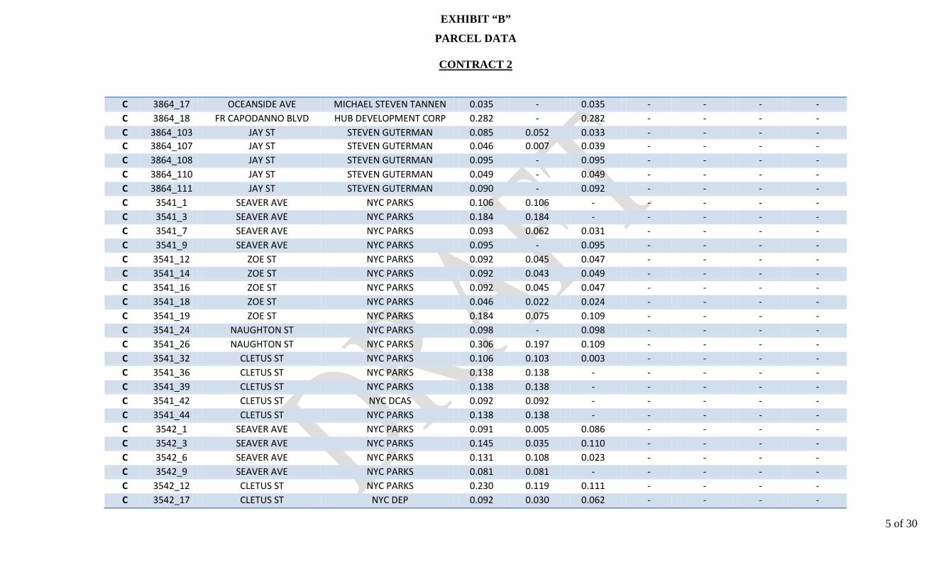
EXHIBIT “B”
PARCEL DATA
CONTRACT 2
5 of 30
C 3864_17 OCEANSIDE AVE MICHAEL STEVEN TANNEN 0.035 - 0.035 - - - - C 3864_18 FR CAPODANNO BLVD HUB DEVELOPMENT CORP 0.282 - 0.282 - - - - C 3864_103 JAY ST STEVEN GUTERMAN 0.085 0.052 0.033 - - - - C 3864_107 JAY ST STEVEN GUTERMAN 0.046 0.007 0.039 - - - - C 3864_108 JAY ST STEVEN GUTERMAN 0.095 - 0.095 - - - - C 3864_110 JAY ST STEVEN GUTERMAN 0.049 - 0.049 - - - - C 3864_111 JAY ST STEVEN GUTERMAN 0.090 - 0.092 - - - - C 3541_1 SEAVER AVE NYC PARKS 0.106 0.106 - - - - - C 3541_3 SEAVER AVE NYC PARKS 0.184 0.184 - - - - - C 3541_7 SEAVER AVE NYC PARKS 0.093 0.062 0.031 - - - - C 3541_9 SEAVER AVE NYC PARKS 0.095 - 0.095 - - - - C 3541_12 ZOE ST NYC PARKS 0.092 0.045 0.047 - - - - C 3541_14 ZOE ST NYC PARKS 0.092 0.043 0.049 - - - - C 3541_16 ZOE ST NYC PARKS 0.092 0.045 0.047 - - - - C 3541_18 ZOE ST NYC PARKS 0.046 0.022 0.024 - - - - C 3541_19 ZOE ST NYC PARKS 0.184 0.075 0.109 - - - - C 3541_24 NAUGHTON ST NYC PARKS 0.098 - 0.098 - - - - C 3541_26 NAUGHTON ST NYC PARKS 0.306 0.197 0.109 - - - - C 3541_32 CLETUS ST NYC PARKS 0.106 0.103 0.003 - - - - C 3541_36 CLETUS ST NYC PARKS 0.138 0.138 - - - - - C 3541_39 CLETUS ST NYC PARKS 0.138 0.138 - - - - - C 3541_42 CLETUS ST NYC DCAS 0.092 0.092 - - - - - C 3541_44 CLETUS ST NYC PARKS 0.138 0.138 - - - - - C 3542_1 SEAVER AVE NYC PARKS 0.091 0.005 0.086 - - - - C 3542_3 SEAVER AVE NYC PARKS 0.145 0.035 0.110 - - - - C 3542_6 SEAVER AVE NYC PARKS 0.131 0.108 0.023 - - - - C 3542_9 SEAVER AVE NYC PARKS 0.081 0.081 - - - - - C 3542_12 CLETUS ST NYC PARKS 0.230 0.119 0.111 - - - - C 3542_17 CLETUS ST NYC DEP 0.092 0.030 0.062 - - - -

EXHIBIT “B”
PARCEL DATA
CONTRACT 2
6 of 30
C 3542_19 CLETUS ST NYC PARKS 0.138 0.032 0.106 - - - - C 3542_22 CLETUS ST NYC PARKS 0.092 0.007 0.085 - - - - C 3542_28 NAUGHTON AVE NYC PARKS 0.108 - 0.108 - - - - C 3542_30 NAUGHTON AVE NYC PARKS 0.111 - 0.111 - - - - C 3542_32 NAUGHTON AVE NYC PARKS 0.430 - 0.430 - - - - C 3542_43 HUSSON ST NYC PARKS 0.321 - 0.321 - - - - C 3544_1 ZOE ST NYC DEP 2.066 0.707 1.359 - - - - C 3545_1 CLETUS ST NYC DEP 1.309 1.060 0.249 - - - - C 3545_26 CLETUS ST NYC DEP 0.062 0.062 - - - - - C 3545_29 CLETUS ST NYC DEP 0.125 0.125 - - - - - C 3545_30 SEAVER AVE NYC DCAS 0.107 0.107 - - - - - C 3545_33 SEAVER AVE NYC DEP 0.207 0.207 - - - - - C 3545_38 SEAVER AVE NYC PARKS 0.092 0.092 - - - - - C 3545_41 HUSSON ST NYC DEP 0.092 0.092 - - - - - C 3545_43 HUSSON ST NYC DCAS 0.092 0.092 - - - - - C 3545_45 HUSSON ST NYC DCAS 0.103 0.103 - - - - - C 3550_1 STOBE AVE NYC DEP 2.145 1.422 0.723 - - - - C 3551_6 STOBE AVE NYC DEP 0.109 - 0.109 - - - - C 3551_8 STOBE AVE NYC DEP 2.014 0.581 1.433 - - - - C 3658_1 HYLAN BLVD NYC DEP 1.662 0.722 0.940 - - - - C 3661_1 LACONIA AVE NYC DEP 1.022 - 1.022 - - - - C 3662_1 BERMUDA PLACE NYC DEP 0.175 0.155 0.020 - - - - C 3663_1 BOUNDARY AVE NYC DEP 0.581 0.355 0.226 - - - - C 3664_4 HYLAN BLVD NYC DEP 0.059 - 0.059 - - - - C 3664_5 HYLAN BLVD NYC DEP 0.059 0.009 0.050 - - - - C 3664_6 HYLAN BLVD NYC DEP 0.058 0.034 0.024 - - - - C 3664_7 HYLAN BLVD NYC DEP 0.058 0.048 0.010 - - - - C 3664_8 HYLAN BLVD NYC DEP 0.115 0.109 0.006 - - - -

EXHIBIT “B”
PARCEL DATA
CONTRACT 2
7 of 30
C 3664_10 BERMUDA PLACE NYC DEP 0.155 0.068 0.087 - - - - C 3665_1 BOUNDARY AVE NYC DEP 1.222 - 1.222 - - - - C 3680_1 MASON AVE NYC DEP 2.302 - 2.302 - - - - C 3680_31 ROWAN AVE NYC DEP 0.096 - 0.096 - - - - C 3696_1 LINCOLN AVE NYC PARKS 3.115 0.823 2.292 - - - - C 3696_30 MIDLAND AVE NYC PARKS 0.347 0.229 0.118 - - - - C 3696_35 BOUNDARY AVE NYC PARKS 2.765 1.961 0.804 - - - - C 3696_100 333 MIDLAND AVE CITY OF NEW YORK 6.171 - 0.125 - - - - C 3708_35 BUEL AVE CITY OF NEW YORK 0.132 - 0.132 - - - - C 3708_43 DONGAN HILLS AVE CITY OF NEW YORK 0.083 - 0.083 - - - - C 3714_1 MASON AVE NYC DEP 2.870 1.962 0.908 - - - - C 3715_1 MASON AVE NYC DEP 2.874 2.747 0.127 - - - - C 3716_14 ROWAN AVE NYC DEP 1.171 - 1.171 - - - - C 3721_99 MASON AVE NYC DEP 1.274 - 1.274 - - - - C 3722_1 HUNTER AVE NYC DEP 0.113 - 0.113 - - - - C 3722_4 HUNTER AVE NYC DEP 0.045 - 0.045 - - - - C 3722_11 HUNTER AVE NYC DEP 0.002 - 0.002 - - - - C 3722_15 HUNTER AVE NYC DEP 0.011 - 0.011 - - - - C 3722_20 HUNTER AVE NYC DEP 0.006 - 0.006 - - - - C 3722_24 439 HUNTER AVE NYC DEP 0.023 - 0.023 - - - - C 3722_27 HUNTER AVE NYC DEP 0.402 - 0.402 - - - - C 3723_3 HUNTER AVE NYC DEP 1.088 - 1.088 - - - - C 3723_22 GRIMSBY ST NYC DEP 0.044 - 0.044 - - - - C 3723_23 GRIMSBY ST NYC DEP 0.196 - 0.196 - - - - C 3723_45 NUGENT AVE NYC DEP 0.129 - 0.129 - - - - C 3723_48 NUGENT AVE NYC DEP 0.174 - 0.174 - - - - C 3723_52 JEFFERSON AVE NYC DEP 0.170 - 0.170 - - - - C 3723_56 JEFFERSON AVE NYC DEP 0.224 - 0.224 - - - -
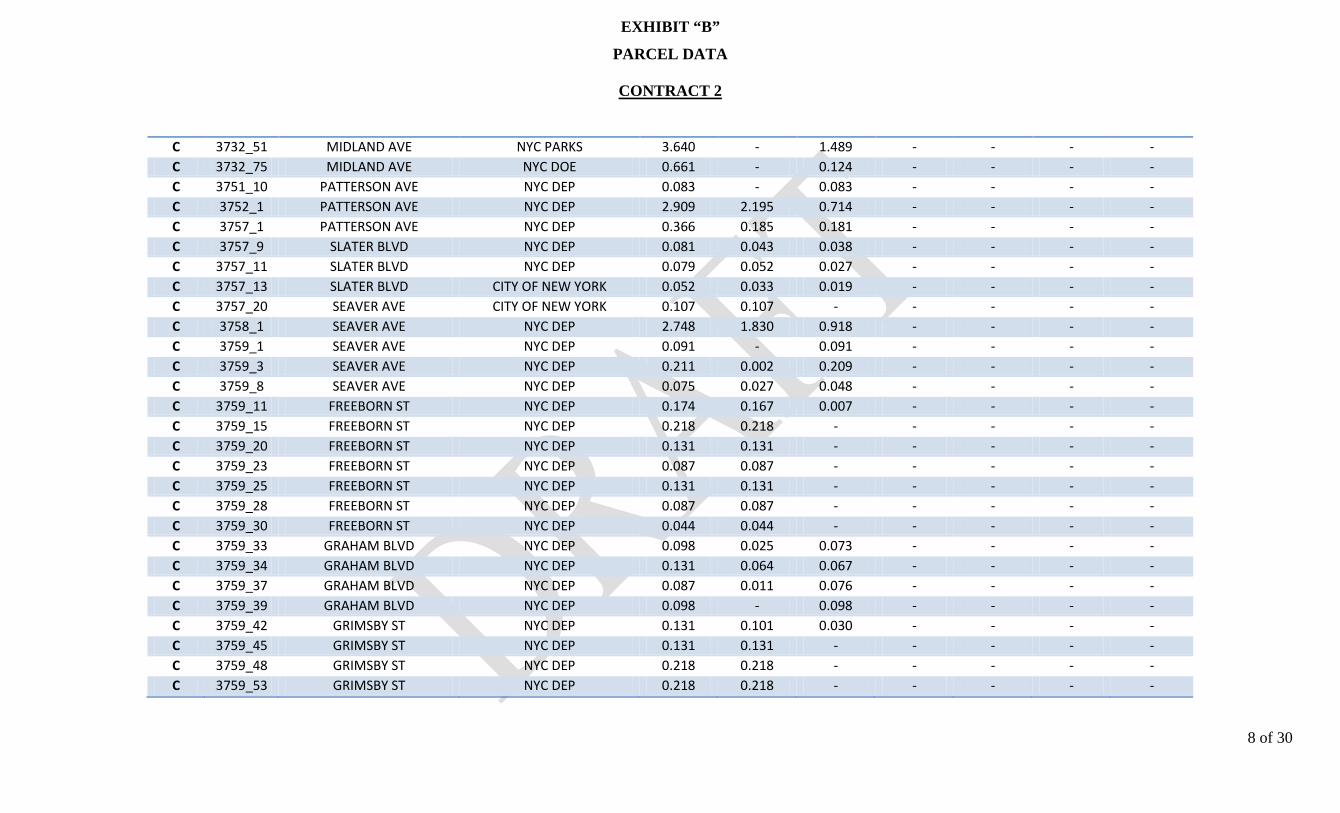
EXHIBIT “B”
PARCEL DATA
CONTRACT 2
8 of 30
C 3732_51 MIDLAND AVE NYC PARKS 3.640 - 1.489 - - - - C 3732_75 MIDLAND AVE NYC DOE 0.661 - 0.124 - - - - C 3751_10 PATTERSON AVE NYC DEP 0.083 - 0.083 - - - - C 3752_1 PATTERSON AVE NYC DEP 2.909 2.195 0.714 - - - - C 3757_1 PATTERSON AVE NYC DEP 0.366 0.185 0.181 - - - - C 3757_9 SLATER BLVD NYC DEP 0.081 0.043 0.038 - - - - C 3757_11 SLATER BLVD NYC DEP 0.079 0.052 0.027 - - - - C 3757_13 SLATER BLVD CITY OF NEW YORK 0.052 0.033 0.019 - - - - C 3757_20 SEAVER AVE CITY OF NEW YORK 0.107 0.107 - - - - - C 3758_1 SEAVER AVE NYC DEP 2.748 1.830 0.918 - - - - C 3759_1 SEAVER AVE NYC DEP 0.091 - 0.091 - - - - C 3759_3 SEAVER AVE NYC DEP 0.211 0.002 0.209 - - - - C 3759_8 SEAVER AVE NYC DEP 0.075 0.027 0.048 - - - - C 3759_11 FREEBORN ST NYC DEP 0.174 0.167 0.007 - - - - C 3759_15 FREEBORN ST NYC DEP 0.218 0.218 - - - - - C 3759_20 FREEBORN ST NYC DEP 0.131 0.131 - - - - - C 3759_23 FREEBORN ST NYC DEP 0.087 0.087 - - - - - C 3759_25 FREEBORN ST NYC DEP 0.131 0.131 - - - - - C 3759_28 FREEBORN ST NYC DEP 0.087 0.087 - - - - - C 3759_30 FREEBORN ST NYC DEP 0.044 0.044 - - - - - C 3759_33 GRAHAM BLVD NYC DEP 0.098 0.025 0.073 - - - - C 3759_34 GRAHAM BLVD NYC DEP 0.131 0.064 0.067 - - - - C 3759_37 GRAHAM BLVD NYC DEP 0.087 0.011 0.076 - - - - C 3759_39 GRAHAM BLVD NYC DEP 0.098 - 0.098 - - - - C 3759_42 GRIMSBY ST NYC DEP 0.131 0.101 0.030 - - - - C 3759_45 GRIMSBY ST NYC DEP 0.131 0.131 - - - - - C 3759_48 GRIMSBY ST NYC DEP 0.218 0.218 - - - - - C 3759_53 GRIMSBY ST NYC DEP 0.218 0.218 - - - - -

EXHIBIT “B”
PARCEL DATA
CONTRACT 2
9 of 30
C 3759_58 GRIMSBY ST NYC DEP 0.174 0.118 0.056 - - - - C 3760_1 SEAVER AVE NYC DEP 0.179 0.021 0.158 - - - - C 3760_5 SEAVER AVE NYC DEP 0.141 - 0.141 - - - - C 3760_9 OLYMPIA BLVD NYC DEP 0.143 0.117 0.026 - - - - C 3760_13 OLYMPIA BLVD NYC DEP 0.184 0.184 - - - - - C 3760_18 OLYMPIA BLVD NYC DEP 0.037 0.037 - - - - - C 3760_19 OLYMPIA BLVD NYC DEP 0.037 0.037 - - - - - C 3760_20 OLYMPIA BLVD NYC DEP 0.038 0.035 0.003 - - - - C 3760_21 OLYMPIA BLVD NYC DEP 0.154 0.102 0.052 - - - - C 3760_25 OLYMPIA BLVD NYC DEP 0.078 0.005 0.073 - - - - C 3760_27 OLYMPIA BLVD NYC DEP 0.079 - 0.079 - - - - C 3760_36 GRAHAM BLVD NYC DEP 0.046 - 0.046 - - - - C 3760_37 GRAHAM BLVD NYC DEP 0.092 - 0.092 - - - - C 3760_40 FREEBORN ST NYC DEP 0.079 0.027 0.052 - - - - C 3760_42 FREEBORN ST NYC DEP 0.078 0.071 0.007 - - - - C 3760_44 FREEBORN ST NYC DEP 0.077 0.077 - - - - - C 3760_46 FREEBORN ST NYC DEP 0.076 0.076 - - - - - C 3760_48 FREEBORN ST NYC DEP 0.075 0.075 - - - - - C 3760_50 FREEBORN ST NYC DEP 0.223 0.223 - - - - - C 3760_56 FREEBORN ST NYC DEP 0.072 0.072 - - - - - C 3760_58 FREEBORN ST NYC DEP 0.071 0.071 - - - - - C 3761_9 COLONY AVE NYC DEP 0.092 0.074 0.018 - - - - C 3761_11 COLONY AVE NYC DEP 0.287 0.287 - - - - - C 3761_17 COLONY AVE NYC DEP 0.092 0.096 - - - - - C 3761_24 COLONY AVE NYC DEP 0.133 - 0.133 - - - - C 3761_27 COLONY AVE NYC DEP 0.128 - 0.128 - - - - C 3761_30 COLONY AVE NYC DEP 0.084 - 0.084 - - - - C 3761_32 GRAHAM BLVD NYC DEP 0.090 - 0.090 - - - -

EXHIBIT “B”
PARCEL DATA
CONTRACT 2
10 of 30
C 3761_34 GRAHAM BLVD NYC DEP 0.092 - 0.092 - - - - C 3761_36 GRAHAM BLVD NYC DEP 0.092 - 0.092 - - - - C 3761_38 GRAHAM BLVD NYC DEP 0.046 - 0.046 - - - - C 3761_42 OLYMPIA BLVD NYC DEP 0.084 - 0.084 - - - - C 3761_44 OLYMPIA BLVD NYC DEP 0.085 - 0.085 - - - - C 3761_46 OLYMPIA BLVD NYC DEP 0.086 - 0.086 - - - - C 3761_48 OLYMPIA BLVD NYC DEP 0.133 - 0.133 - - - - C 3761_51 OLYMPIA BLVD NYC DEP 0.135 - 0.135 - - - - C 3761_54 OLYMPIA BLVD NYC DEP 0.092 0.017 0.075 - - - - C 3761_56 OLYMPIA BLVD NYC DEP 0.046 0.044 0.002 - - - - C 3761_57 OLYMPIA BLVD NYC DEP 0.093 0.091 0.002 - - - - C 3761_59 OLYMPIA BLVD NYC DEP 0.191 0.183 0.008 - - - - C 3763_1 SEAVER AVE CITY OF NEW YORK 0.147 0.147 - - - - - C 3763_4 SEAVER AVE CITY OF NEW YORK 0.135 0.135 - - - - - C 3763_7 SEAVER AVE CITY OF NEW YORK 0.146 0.146 - - - - - C 3763_10 PATTERSON AVE CITY OF NEW YORK 0.087 0.087 - - - - - C 3763_12 PATTERSON AVE CITY OF NEW YORK 0.087 0.087 - - - - - C 3763_14 PATTERSON AVE CITY OF NEW YORK 0.087 0.087 - - - - - C 3763_17 PATTERSON AVE CITY OF NEW YORK 0.131 0.131 - - - - - C 3763_19 PATTERSON AVE CITY OF NEW YORK 0.044 0.044 - - - - - C 3763_20 PATTERSON AVE CITY OF NEW YORK 0.065 0.065 - - - - - C 3763_22 PATTERSON AVE CITY OF NEW YORK 0.065 0.064 - - - - - C 3763_23 PATTERSON AVE CITY OF NEW YORK 0.044 0.042 0.002 - - - - C 3763_24 PATTERSON AVE CITY OF NEW YORK 0.131 0.093 0.038 - - - - C 3763_27 PATTERSON AVE NYC DEP 0.181 0.131 0.050 - - - - C 3763_32 GRAHAM BLVD NYC DEP 0.103 0.046 0.057 - - - - C 3763_34 GRAHAM BLVD NYC DEP 0.046 0.046 - - - - - C 3763_35 GRAHAM BLVD CITY OF NEW YORK 0.092 0.090 0.002 - - - -

EXHIBIT “B”
PARCEL DATA
CONTRACT 2
11 of 30
C 3763_37 GRAHAM BLVD CITY OF NEW YORK 0.092 0.092 0.000 - - - - C 3764_1 JEFFERSON AVE NYC DEP 0.124 - 0.124 - - - - C 3764_4 JEFFERSON AVE NYC DEP 0.156 - 0.156 - - - - C 3764_8 JEFFERSON AVE NYC DEP 0.092 - 0.092 - - - - C 3764_38 GRIMSBY ST NYC DEP 0.044 - 0.044 - - - - C 3764_39 GRIMSBY ST NYC DEP 0.044 - 0.044 - - - - C 3764_40 GRIMSBY ST NYC DEP 0.044 - 0.044 - - - - C 3765_1 JEFFERSON AVE NYC DEP 0.115 - 0.115 - - - - C 3765_4 JEFFERSON AVE NYC DEP 0.073 - 0.073 - - - - C 3765_6 JEFFERSON AVE NYC DEP 0.037 - 0.037 - - - - C 3765_7 JEFFERSON AVE NYC DEP 0.122 - 0.122 - - - - C 3765_11 GRIMSBY ST NYC DEP 0.087 - 0.087 - - - - C 3765_13 GRIMSBY ST NYC DEP 0.044 - 0.044 - - - - C 3765_37 FREEBORN ST NYC DEP 0.046 - 0.046 - - - - C 3765_38 FREEBORN ST NYC DEP 0.092 - 0.092 - - - - C 3766_1 JEFFERSON AVE NYC DEP 0.083 - 0.083 - - - - C 3766_3 JEFFERSON AVE NYC DEP 0.084 - 0.084 - - - - C 3766_5 JEFFERSON AVE NYC DEP 0.127 - 0.127 - - - - C 3766_8 JEFFERSON AVE NYC DEP 0.087 - 0.087 - - - - C 3766_11 FREEBORN ST NYC DEP 0.083 - 0.083 - - - - C 3766_35 OLYMPIA BLVD NYC DEP 0.041 - 0.041 - - - - C 3766_36 OLYMPIA BLVD NYC DEP 0.083 - 0.083 - - - - C 3767_1 JEFFERSON AVE CITY OF NEW YORK 0.074 0.074 - - - - - C 3767_3 JEFFERSON AVE CITY OF NEW YORK 0.078 0.078 - - - - - C 3767_5 JEFFERSON AVE CITY OF NEW YORK 0.197 0.197 - - - - - C 3768_1 JEFFERSON AVE CITY OF NEW YORK 0.082 0.082 - - - - - C 3768_3 JEFFERSON AVE CITY OF NEW YORK 0.036 0.036 - - - - - C 3768_4 JEFFERSON AVE NYC DEP 0.603 0.348 0.255 - - - -

EXHIBIT “B”
PARCEL DATA
CONTRACT 2
12 of 30
C 3768_8 JEFFERSON AVE CITY OF NEW YORK 0.082 0.082 - - - - - C 3769_1 JEFFERSON AVE NYC DEP 0.138 0.003 0.135 - - - - C 3769_4 JEFFERSON AVE CITY OF NEW YORK 0.170 0.163 0.007 - - - - C 3769_8 JEFFERSON AVE CITY OF NEW YORK 0.095 0.095 - - - - - C 3769_11 BADEN PLACE CITY OF NEW YORK 0.131 0.130 0.001 - - - - C 3769_14 BADEN PLACE NYC DEP 0.404 0.215 0.189 - - - - C 3769_19 GRAHAM BLVD CITY OF NEW YORK 0.149 0.041 0.108 - - - - C 3769_22 GRAHAM BLVD CITY OF NEW YORK 0.046 0.037 0.009 - - - - C 3769_23 GRAHAM BLVD CITY OF NEW YORK 0.138 0.082 0.056 - - - - C 3769_26 GRAHAM BLVD NYC DEP 0.103 - 0.103 - - - - C 3769_29 PATTERSON AVE NYC DEP 0.087 0.034 0.053 - - - - C 3790_12 GRIMSBY ST NYC DEP 0.044 - 0.044 - - - - C 3790_13 GRIMSBY ST NYC DEP 0.044 - 0.044 - - - - C 3790_14 GRIMSBY ST NYC DEP 0.044 - 0.044 - - - - C 3790_15 GRIMSBY ST NYC DEP 0.044 - 0.044 - - - - C 3790_16 GRIMSBY ST NYC DEP 0.044 - 0.044 - - - - C 3790_17 GRIMSBY ST NYC DEP 0.044 - 0.044 - - - - C 3790_18 GRIMSBY ST NYC DEP 0.044 - 0.044 - - - - C 3790_19 GRIMSBY ST NYC DEP 0.044 - 0.044 - - - - C 3790_20 GRIMSBY ST NYC DEP 0.044 - 0.044 - - - - C 3790_21 GRIMSBY ST NYC DEP 0.044 - 0.044 - - - - C 3790_22 GRIMSBY ST NYC DEP 0.044 - 0.044 - - - - C 3790_23 GRIMSBY ST NYC DEP 0.120 - 0.120 - - - - C 3790_31 JEFFERSON AVE NYC DEP 0.479 - 0.479 - - - - C 3790_45 FREEBORN ST NYC DEP 0.109 - 0.109 - - - - C 3791_22 FREEBORN ST NYC DEP 0.109 - 0.109 - - - - C 3791_31 JEFFERSON AVE NYC DEP 0.373 - 0.373 - - - - C 3792_21 OLYMPIA BLVD NYC DEP 0.123 - 0.123 - - - -
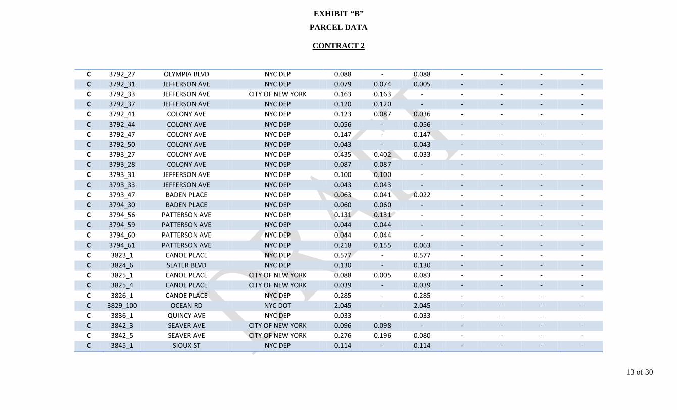
EXHIBIT “B”
PARCEL DATA
CONTRACT 2
13 of 30
C 3792_27 OLYMPIA BLVD NYC DEP 0.088 - 0.088 - - - - C 3792_31 JEFFERSON AVE NYC DEP 0.079 0.074 0.005 - - - - C 3792_33 JEFFERSON AVE CITY OF NEW YORK 0.163 0.163 - - - - - C 3792_37 JEFFERSON AVE NYC DEP 0.120 0.120 - - - - - C 3792_41 COLONY AVE NYC DEP 0.123 0.087 0.036 - - - - C 3792_44 COLONY AVE NYC DEP 0.056 - 0.056 - - - - C 3792_47 COLONY AVE NYC DEP 0.147 - 0.147 - - - - C 3792_50 COLONY AVE NYC DEP 0.043 - 0.043 - - - - C 3793_27 COLONY AVE NYC DEP 0.435 0.402 0.033 - - - - C 3793_28 COLONY AVE NYC DEP 0.087 0.087 - - - - - C 3793_31 JEFFERSON AVE NYC DEP 0.100 0.100 - - - - - C 3793_33 JEFFERSON AVE NYC DEP 0.043 0.043 - - - - - C 3793_47 BADEN PLACE NYC DEP 0.063 0.041 0.022 - - - - C 3794_30 BADEN PLACE NYC DEP 0.060 0.060 - - - - - C 3794_56 PATTERSON AVE NYC DEP 0.131 0.131 - - - - - C 3794_59 PATTERSON AVE NYC DEP 0.044 0.044 - - - - - C 3794_60 PATTERSON AVE NYC DEP 0.044 0.044 - - - - - C 3794_61 PATTERSON AVE NYC DEP 0.218 0.155 0.063 - - - - C 3823_1 CANOE PLACE NYC DEP 0.577 - 0.577 - - - - C 3824_6 SLATER BLVD NYC DEP 0.130 - 0.130 - - - - C 3825_1 CANOE PLACE CITY OF NEW YORK 0.088 0.005 0.083 - - - - C 3825_4 CANOE PLACE CITY OF NEW YORK 0.039 - 0.039 - - - - C 3826_1 CANOE PLACE NYC DEP 0.285 - 0.285 - - - - C 3829_100 OCEAN RD NYC DOT 2.045 - 2.045 - - - - C 3836_1 QUINCY AVE NYC DEP 0.033 - 0.033 - - - - C 3842_3 SEAVER AVE CITY OF NEW YORK 0.096 0.098 - - - - - C 3842_5 SEAVER AVE CITY OF NEW YORK 0.276 0.196 0.080 - - - - C 3845_1 SIOUX ST NYC DEP 0.114 - 0.114 - - - -
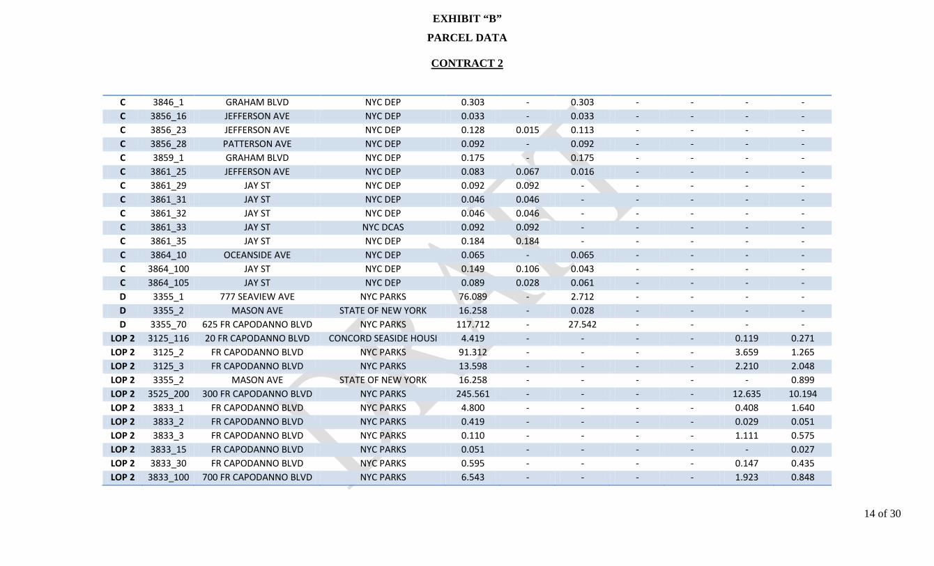
EXHIBIT “B”
PARCEL DATA
CONTRACT 2
14 of 30
C 3846_1 GRAHAM BLVD NYC DEP 0.303 - 0.303 - - - - C 3856_16 JEFFERSON AVE NYC DEP 0.033 - 0.033 - - - - C 3856_23 JEFFERSON AVE NYC DEP 0.128 0.015 0.113 - - - - C 3856_28 PATTERSON AVE NYC DEP 0.092 - 0.092 - - - - C 3859_1 GRAHAM BLVD NYC DEP 0.175 - 0.175 - - - - C 3861_25 JEFFERSON AVE NYC DEP 0.083 0.067 0.016 - - - - C 3861_29 JAY ST NYC DEP 0.092 0.092 - - - - - C 3861_31 JAY ST NYC DEP 0.046 0.046 - - - - - C 3861_32 JAY ST NYC DEP 0.046 0.046 - - - - - C 3861_33 JAY ST NYC DCAS 0.092 0.092 - - - - - C 3861_35 JAY ST NYC DEP 0.184 0.184 - - - - - C 3864_10 OCEANSIDE AVE NYC DEP 0.065 - 0.065 - - - - C 3864_100 JAY ST NYC DEP 0.149 0.106 0.043 - - - - C 3864_105 JAY ST NYC DEP 0.089 0.028 0.061 - - - - D 3355_1 777 SEAVIEW AVE NYC PARKS 76.089 - 2.712 - - - - D 3355_2 MASON AVE STATE OF NEW YORK 16.258 - 0.028 - - - - D 3355_70 625 FR CAPODANNO BLVD NYC PARKS 117.712 - 27.542 - - - -
LOP 2 3125_116 20 FR CAPODANNO BLVD CONCORD SEASIDE HOUSI 4.419 - - - - 0.119 0.271 LOP 2 3125_2 FR CAPODANNO BLVD NYC PARKS 91.312 - - - - 3.659 1.265 LOP 2 3125_3 FR CAPODANNO BLVD NYC PARKS 13.598 - - - - 2.210 2.048 LOP 2 3355_2 MASON AVE STATE OF NEW YORK 16.258 - - - - - 0.899 LOP 2 3525_200 300 FR CAPODANNO BLVD NYC PARKS 245.561 - - - - 12.635 10.194 LOP 2 3833_1 FR CAPODANNO BLVD NYC PARKS 4.800 - - - - 0.408 1.640 LOP 2 3833_2 FR CAPODANNO BLVD NYC PARKS 0.419 - - - - 0.029 0.051 LOP 2 3833_3 FR CAPODANNO BLVD NYC PARKS 0.110 - - - - 1.111 0.575 LOP 2 3833_15 FR CAPODANNO BLVD NYC PARKS 0.051 - - - - - 0.027 LOP 2 3833_30 FR CAPODANNO BLVD NYC PARKS 0.595 - - - - 0.147 0.435 LOP 2 3833_100 700 FR CAPODANNO BLVD NYC PARKS 6.543 - - - - 1.923 0.848
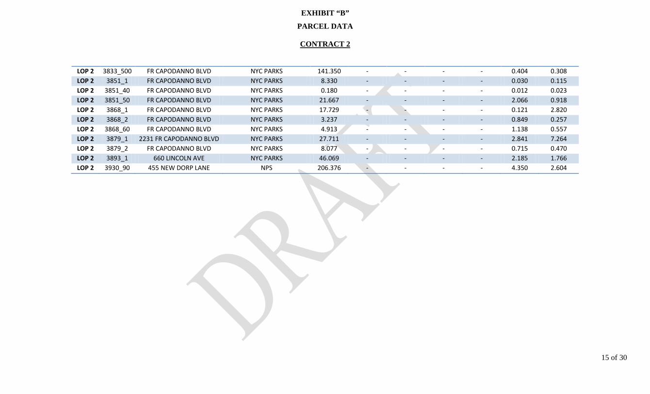
EXHIBIT “B”
PARCEL DATA
CONTRACT 2
15 of 30
LOP 2 3833_500 FR CAPODANNO BLVD NYC PARKS 141.350 - - - - 0.404 0.308 LOP 2 3851_1 FR CAPODANNO BLVD NYC PARKS 8.330 - - - - 0.030 0.115 LOP 2 3851_40 FR CAPODANNO BLVD NYC PARKS 0.180 - - - - 0.012 0.023 LOP 2 3851_50 FR CAPODANNO BLVD NYC PARKS 21.667 - - - - 2.066 0.918 LOP 2 3868_1 FR CAPODANNO BLVD NYC PARKS 17.729 - - - - 0.121 2.820 LOP 2 3868_2 FR CAPODANNO BLVD NYC PARKS 3.237 - - - - 0.849 0.257 LOP 2 3868_60 FR CAPODANNO BLVD NYC PARKS 4.913 - - - - 1.138 0.557 LOP 2 3879_1 2231 FR CAPODANNO BLVD NYC PARKS 27.711 - - - - 2.841 7.264 LOP 2 3879_2 FR CAPODANNO BLVD NYC PARKS 8.077 - - - - 0.715 0.470 LOP 2 3893_1 660 LINCOLN AVE NYC PARKS 46.069 - - - - 2.185 1.766 LOP 2 3930_90 455 NEW DORP LANE NPS 206.376 - - - - 4.350 2.604

EXHIBIT “C”
LERRD SUMMARY TABLE

EXHBIT “C”
LERRD SUMMARY TABLE
CONTRACT 1 CONTRACT 2
Contract Area A B LOP-1 C D E LOP-2 Totals
Num
ber
of P
arce
ls Privately-Owned 30 50 41 117 0 36 1 275
Publicly-Owned (Non-Fed) 37 20 28 260 3 32 20 400 Federally-Owned - 1 - - - - 1 2
Total Impacted Parcels 67 71 69 377 3 68 22 6771
Perm
anen
t Ea
sem
ents
Flowage Easement - ±47.77 ac - ±39.69 ac - ±24.62 ac - ±112.08 ac Restrictive Easement ±11.64 ac ±41.62 ac - ±47.00 ac ±30.28 ac ±13.30 ac - ±143.84 ac Flood Protection Levee Easement - - ±50.67ac - - - ±36.95 ac ±87.62 ac Pipeline Easement - ±0.09 ac - - - - - ±0.09 ac Road Easement - - ±1.14ac - - - - ±1.14 ac
Tem
pora
ry
Ease
men
ts
Temporary Work Area Easement - - ±27.27 ac - - - ±35.36 ac ±62.62 ac
Total Project Acres ±11.64ac ±89.48 ac ±79.08 ac ±86.69 ac ±30.28 ac ±37.91 ac ±72.31 ac ±407.40 ac
LE
RR
D C
osts
LER $2,657,314 $3,748,396 $4,469,609 $7,459,183 $7,624,666 $3,429,352 $439,377 $29,827,897 Relocation (Road Raises) $0 $1,659,000 $0 $1,946,000 $0 $0 $0 $3,605,000 Relocation (Boardwalk) $0 $0 $0 $0 $0 $0 $28,621,000 $28,621,000 Disposals $0 $0 $0 $0 $0 $0 $0 $0
Total 01-Lands & Damages $2,657,314 $5,407,396 $4,469,609 $9,405,183 $7,624,666 $3,429,352 $29,060,377 $62,053,8972
1 The Project only impacts 666 parcels as identified in paragraph 3.c. The 677 parcels provided in this table account for occurrences where more than one easement is required over the same parcel, i.e. where a parcel is impacted by the Interior Drainage (requiring a flowage easement) and the LOP (requiring a levee protection easement) proposals. 2 The total 01-Land & Damages does not include the contingency. With contingency, total costs is $86,441,000 (rounded) (see paragraph 11).

EXHIBIT “D”
STANDARD ESTATES

EXHIBIT “D”
STANDARD ESTATES
1 of 3
1. FLOWAGE EASEMENT (Portions of Land to be Subjected to Permanent Inundation and Portions to be Subjected to Occasional Flooding) (Standard Estate No. 7) The perpetual right, power, privilege and easement in, upon, over and across Tracts Nos. __________ for the purposes set forth below:
a. Permanently to overflow, flood and submerge the land lying below elevation _____________ in connection with the operation and maintenance of the project for the purposes as authorized by the Act of Congress approved _____________, together with all right, title and interest in and to the timber and the continuing right to clear and remove any brush, debris and natural obstructions which, in the opinion of the representative of the United States in charge of the project may be detrimental to the project.
b. Occasionally to overflow, flood and submerge the land lying above elevation
____________ in connection with the operation and maintenance of said project.
Together with all right, title and interest in and to the structures and improvements now situate on the land, except fencing above elevation __________ (and also excepting __________, (here identify those structures not designed for human habitation which the District Engineer determines may remain on the land)) 3 provided that no structures for human habitation shall be constructed or maintained on the land 4, that no other structures shall be constructed or maintained on the land except as may be approved in writing by the representative of the United States in charge of the project, and that no excavation shall be conducted and no landfill placed on the land without such approval as to the location and method of excavation and/or placement of landfill; 5 the above estate is taken subject to existing easements for public roads and highways, public utilities, railroads and pipelines; reserving, however, to the landowners, their heirs and assigns, all such rights and privileges as may be used and enjoyed without interfering with the use of the project for the purposes authorized by Congress or abridging the rights and easement hereby acquired; provided further that any use of the land shall be subject to Federal and State laws with respect to pollution.
3 Any structures existing in areas that will be allowed to remain must be evaluated using the same criteria that would be used to grant permission for a new structure to be placed in the easement, in coordination with the operational office. 4 Where substantial residential structures exist in areas subject to very infrequent flooding, and will not interfere with project operations, the following clause may be substituted: “however, leaving these structures in place must be evaluated using the same criteria that would be used to grant permission for a new residential structure to be placed in the easement (and also excepting the structure(s) now existing on the land, described as _________, which may be maintained on the land provided that portion of the structure(s) located below elevation __________ feet, mean sea level, shall be utilized for human habitation to the extent that sleeping accommodations will be maintained therein)”. The next clause would then be modified to read “provided that no other structures for . . .” 5 If sand and gravel or other quarriable material is in the easement area and the excavation thereof will not interfere with the operation of the project, the following clause will be added: “excepting that excavation for the purpose of quarrying (sand) (gravel) (etc.) shall be permitted, subject only to such approval as to the placement of overburden, if any, in connection with such excavation;”
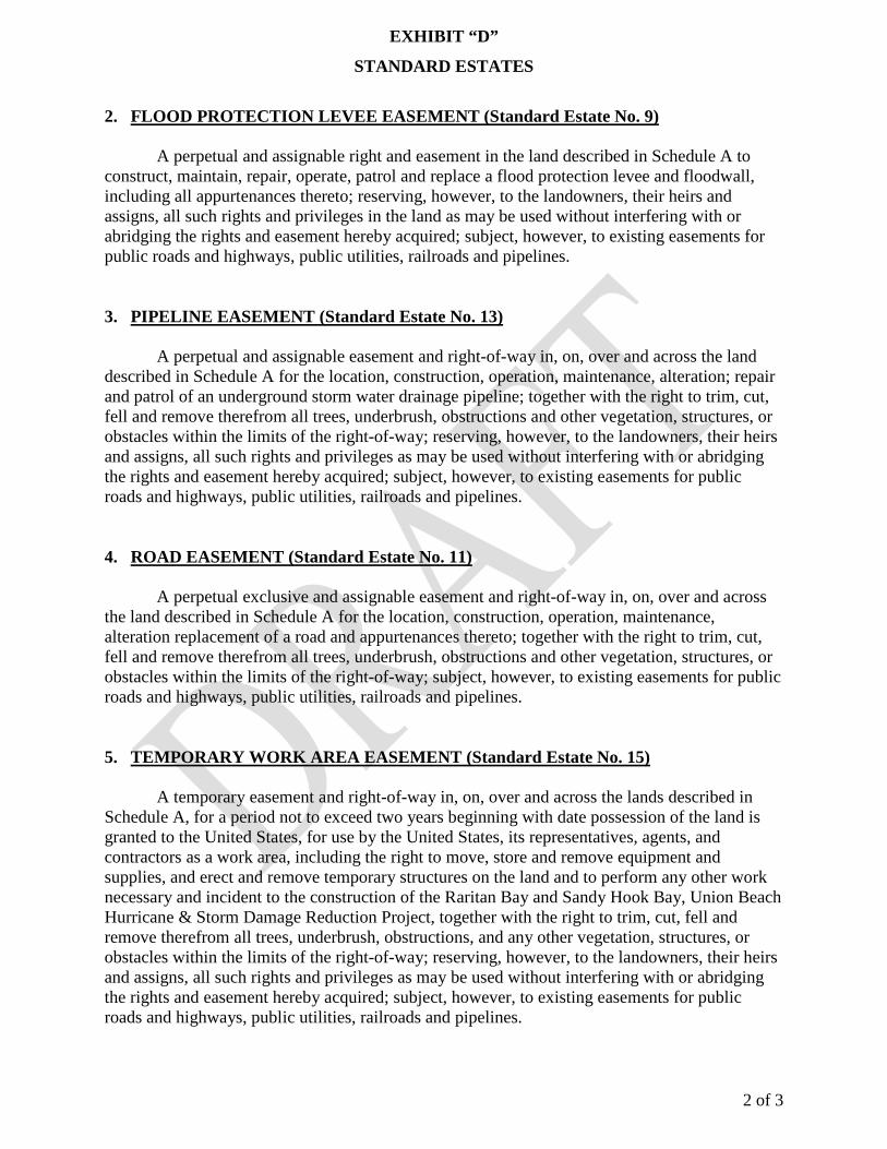
EXHIBIT “D”
STANDARD ESTATES
2 of 3
2. FLOOD PROTECTION LEVEE EASEMENT (Standard Estate No. 9) A perpetual and assignable right and easement in the land described in Schedule A to construct, maintain, repair, operate, patrol and replace a flood protection levee and floodwall, including all appurtenances thereto; reserving, however, to the landowners, their heirs and assigns, all such rights and privileges in the land as may be used without interfering with or abridging the rights and easement hereby acquired; subject, however, to existing easements for public roads and highways, public utilities, railroads and pipelines. 3. PIPELINE EASEMENT (Standard Estate No. 13) A perpetual and assignable easement and right-of-way in, on, over and across the land described in Schedule A for the location, construction, operation, maintenance, alteration; repair and patrol of an underground storm water drainage pipeline; together with the right to trim, cut, fell and remove therefrom all trees, underbrush, obstructions and other vegetation, structures, or obstacles within the limits of the right-of-way; reserving, however, to the landowners, their heirs and assigns, all such rights and privileges as may be used without interfering with or abridging the rights and easement hereby acquired; subject, however, to existing easements for public roads and highways, public utilities, railroads and pipelines. 4. ROAD EASEMENT (Standard Estate No. 11) A perpetual exclusive and assignable easement and right-of-way in, on, over and across the land described in Schedule A for the location, construction, operation, maintenance, alteration replacement of a road and appurtenances thereto; together with the right to trim, cut, fell and remove therefrom all trees, underbrush, obstructions and other vegetation, structures, or obstacles within the limits of the right-of-way; subject, however, to existing easements for public roads and highways, public utilities, railroads and pipelines. 5. TEMPORARY WORK AREA EASEMENT (Standard Estate No. 15) A temporary easement and right-of-way in, on, over and across the lands described in Schedule A, for a period not to exceed two years beginning with date possession of the land is granted to the United States, for use by the United States, its representatives, agents, and contractors as a work area, including the right to move, store and remove equipment and supplies, and erect and remove temporary structures on the land and to perform any other work necessary and incident to the construction of the Raritan Bay and Sandy Hook Bay, Union Beach Hurricane & Storm Damage Reduction Project, together with the right to trim, cut, fell and remove therefrom all trees, underbrush, obstructions, and any other vegetation, structures, or obstacles within the limits of the right-of-way; reserving, however, to the landowners, their heirs and assigns, all such rights and privileges as may be used without interfering with or abridging the rights and easement hereby acquired; subject, however, to existing easements for public roads and highways, public utilities, railroads and pipelines.

EXHIBIT “D”
STANDARD ESTATES
3 of 3
6. RESTRICTIVE EASEMENT (Standard Estate No. 16)
A perpetual and assignable easement for the establishment, maintenance, operation and use for a restrictive area in, on, over and across the land described in Schedule A consisting of the right to prohibit human habitation; the right to remove buildings presently or hereafter being used for human habitation; the right to prohibit gatherings of more than twenty-five (25) persons; the right to post signs indicating the nature and extent of the Government's control; and the right of ingress and egress over and across said land for the purpose of exercising the rights set forth herein; subject, however, to existing easements for public roads and highways, public utilities, railroads and pipelines; reserving, however, to the landowners, their heirs and assigns, all such rights and privileges as may be used without interfering with or abridging the rights and easement hereby acquired.

EXHIBIT “E”
BASELINE COST ESTATE FOR REAL ESTATE

EXHIBIT “E”
BASELINE COST ESTATE FOR REAL ESTATE
SOUTH SHORE OF STATEN ISLAND COASTAL STORM RISK MANAGEMENT
TOTAL PROJECT REAL ESTATE COSTS (Cost-Shared 65%-35%) Non-Federal Federal Project Cost
Cost Summary:
Incidental Costs (01A) $3,385,000 $975,400 $4,360,400 Real Estate Acquisition Costs (01B) $57,693,497 $0 $57,693,497 Subtotal: $61,078,497 $975,400 $62,053,897 39.3% Contingency, Less Land Payments (01B1 ) $24,003,849 $383,332 $24,387,182
01 LANDS AND DAMAGES $85,082,346 $1,358,732 $86,441,0796
01A INCIDENTAL COSTS $3,385,000 $975,400 $4,360,400 01A1
Acquisition (Admin Costs)
$175,000
$77,000
01A1A By Government (Gov't) $77,000 01A1B By Non-Federal Sponsor (NFS) $175,000 01A1C By Gov't on behalf of NFS 01A2
Survey
$350,000
$140,000
01A2A By Gov't (In-house) 01A2B By Gov't (Contract) 01A2C By NFS $350,000 01A2D By Gov't on behalf of NFS 01A2E Review of NFS $140,000 01A3
Appraisal
$1,400,000
$350,000
01A3A By Gov't (In-house) 01A3B By Gov't (Contract) 01A3C By NFS $1,400,000 01A3D By Gov't on behalf of NFS 01A3E Review of NFS $350,000 01A4
Title Services
$1,460,000
$58,400
01A4A By Gov't (Contract) 01A4B By NFS $1,460,000 01A4C By Gov't on behalf of NFS 01A4D Review of NFS $58,400 01A5
Other Professional Services
$0
$0
01A5A By the Gov't 01A5B By the NFS 01A5C By Gov't on behalf of NFS 01A5D Review of NFS
6 The Project’s total reported 01-Lands & Damages is $86,441,000 (rounded).

EXHIBIT “E”
BASELINE COST ESTATE FOR REAL ESTATE
01A6 Closing Cost (4% of Land Payments-01C1) $0 $0 01A6A By Gov't 01A6B By NFS 01A6C By Gov't on behalf of NFS 01A7
PL 91-646 Assistance
$0
$0
01A7A By Government 01A7B By NFS 01A7C By Gov't on behalf of NFS 01A7D Review of NFS 01A8
Audit
$0
$350,000
01A8A By Gov't $350,000 01A9B By NFS 01B REAL ESTATE ACQUISITION COSTS $57,693,497 $0 $57,693,497 01B1
Land Payments
$25,467,497
$0
01B1A By Government 01B1B By NFS $25,467,497 01B1C By Gov't on behalf of NFS 01B2
Damage Payments
$0
$0
01B2A By Government 01C2B By NFS 01C2C By Gov't on behalf of NFS 01B3
PL 91-646 Payment
$0
$0
01B3A By Government 01B3B By NFS 01B3C By Gov't on behalf of NFS 01B4
Condemnation
$0
$0
01B4A By NFS 01B5
Facility / Utility Relocations
$32,226,000
$0
01B5A By NFS $32,226,000 01B5B By Government 01B6
Disposals
$0
$0
01B6A By Government 01B6B By NFS 01B6C By Gov't on behalf of NFS

EXHIBIT “F”
PRELIMINARY ATTORNEY’S OPINION OF COMPENSABILITY
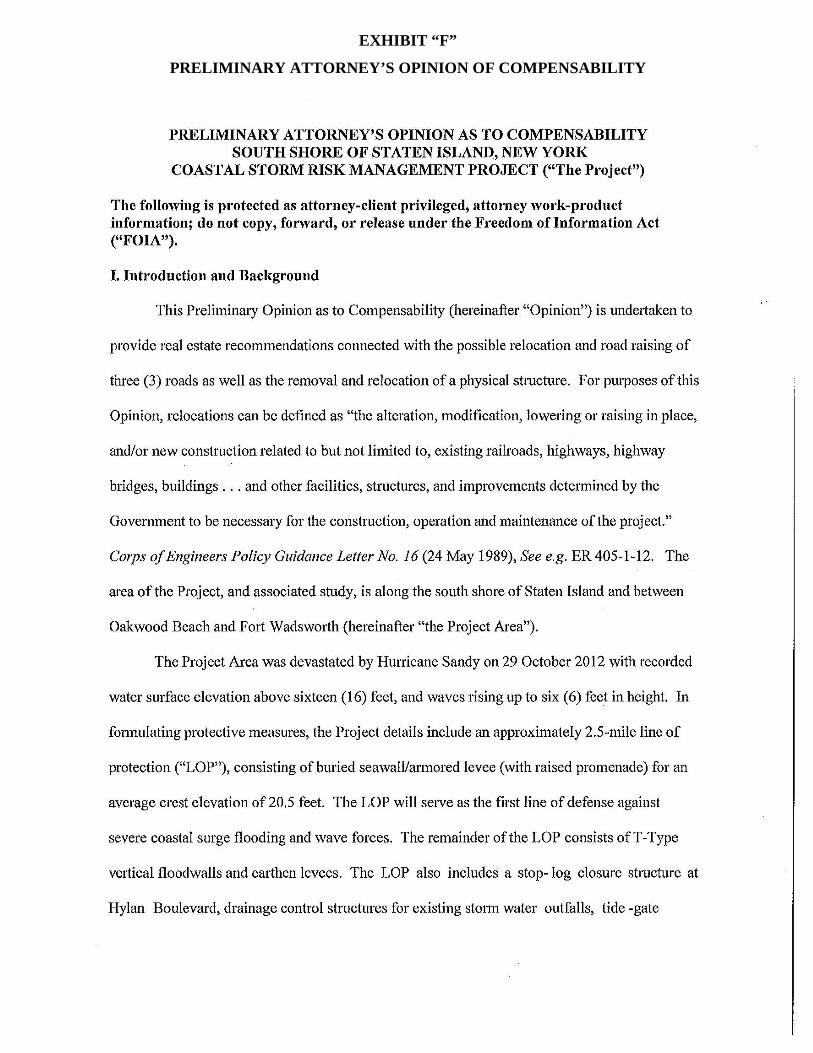
EXHIBIT “F”
PRELIMINARY ATTORNEY’S OPINION OF COMPENSABILITY

EXHIBIT “F”
PRELIMINARY ATTORNEY’S OPINION OF COMPENSABILITY

EXHIBIT “F”
PRELIMINARY ATTORNEY’S OPINION OF COMPENSABILITY
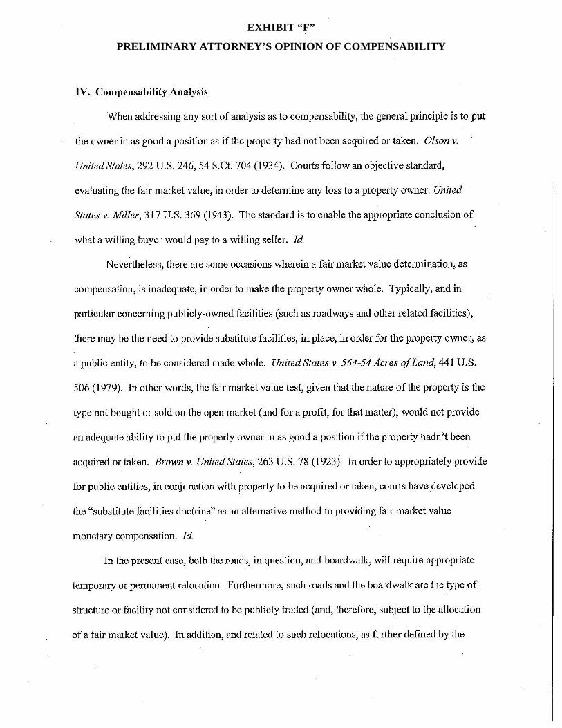
EXHIBIT “F”
PRELIMINARY ATTORNEY’S OPINION OF COMPENSABILITY

EXHIBIT “F”
PRELIMINARY ATTORNEY’S OPINION OF COMPENSABILITY

EXHIBIT “G”
PHYSICAL TAKINGS ANALYSIS

EXHIBIT “G”
PHYSICAL TAKINGS ANALYSIS
PHYSICAL TAKINGS ANALYSIS SOUTH SHORE OF STATEN ISLAND, NEW YORK
COASTAL STORM RISK MANAGEMENT PROJECT (“The Project”) The following is protected as attorney-client privileged, attorney work-product information; do not copy, forward, or release under the Freedom of Information Act (“FOIA”). I. Introduction and Background
The South Shore of Staten Island Coastal Storm Risk Management Project (hereinafter
the “Project”) is a group of 549 properties located on the south shore of Staten Island in five (5)
drainage areas containing 535.01 acres situated in the Borough of Staten Island, Richmond
County, New York. The Project extends approximately three (3) linear miles from Fort
Wadsworth to Oakwood Beach along the northern end of the south shoreline of Staten Island
(hereinafter the “Project Area”). The purpose of the Project is to provide coastal flood risk
management to flood-prone, high-risk, low-lying residential and commercial structures along the
south shore of Staten Island. The vast majority of the privately-owned parcels are located with
residential zoning districts. Based on design of the project, the areas directly affected will consist
primarily of unimproved beach areas and vacant and improved residential property that fall
within the interior drainage areas. The engineering solution is a plan that provides for coastal risk
management in the form of a structural Line of Protection (LOP) consisting of levees, floodwalls
and a buried seawall/armored levee and interior drainage area.
The Project Area was devastated by Hurricane Sandy on 29 October 2012 with recorded
water surface elevation above sixteen (16) feet, and waves rising up to six (6) feet in height. In
formulating protective measures, the Project details include an approximately 2.5-mile line of
protection (“LOP”), consisting of buried seawall/armored levee (with raised promenade) for an
average crest elevation of 20.5 feet. The LOP will serve as the first line of defense against
EXHIBIT “G”
PHYSICAL TAKINGS ANALYSIS
severe coastal surge flooding and wave forces. The remainder of the LOP consists of T-Type
vertical floodwalls and earthen levees. The LOP also includes a stop- log closure structure at
Hylan Boulevard, drainage control structures for existing storm water outfalls, tide-gate
structures, vehicle and pedestrian access structures, and demolition of an existing boardwalk with
the replacement of a functionally-equivalent one. A full description of the Project is outlined in
the related Planning documents, including therein, the draft Real Estate Plan.
As stated in the draft Real Estate Plan, a cooperative beach erosion and storm damage
reduction study was, originally, authorized by a resolution of the U.S. House of Representatives
Committee on Public Works and Transportation and adopted 13 May 1993. The resolution states
that:
“The Secretary of the Army, acting through the Chief of Engineers, is requested to review the report of the Chief of Engineers, on the Staten Island Coast from Fort Wadsworth to Arthur Kill, New York, published as House Document 181, Eighty- ninth Congress, First Session, and other pertinent reports, to determine whether modifications of the recommendations contained therein are advisable at the present time, in the interest of beach erosion control, storm damage reduction and related purposes on the South Shore of Staten Island, New York, particularly in and adjacent to the communities of New Dorp Beach, Oakwood Beach, and Annadale Beach, New York.”
Furthermore, as addressed in the related draft Real Estate Plan, the Disaster Relief
Appropriations Act of 2013, Public Law 113-2, enacted on 29 January 2013 (hereinafter “P.L.
113-2”) authorizes the Secretary of the Army to utilize funds provided in P.L. 113-2, in order to
complete construction of certain authorized but unconstructed projects, including the
construction of this Project.
II. Restrictions of Scope and Subject Matter
The Analysis, herein, is restricted in its review given the lack of title information
provided as well as limitations associated with the draft Interim Interior Drainage Report. This
Analysis does not cover other possible compensable interests involved in the Project. In

EXHIBIT “G”
PHYSICAL TAKINGS ANALYSIS
addition, it is understood that this Analysis is preliminary in nature and will be contingent upon
the execution of a final agreement as may be entered into between Corps of Engineers, New
York District (“NAN”) and the Project, non-Federal sponsor, as well as the provision of
satisfactory title evidence, and the completion of the final plans and specifications of the Project
design, inclusive of any related hydrology issues to be addressed.
III. Interior Drainage Areas
As part of the Project, a certain number of parcels include natural, interior drainage,
inclusive of natural storage, channels, and other naturally-occurring drainage and related
drainage facilities. These existing interior drainage facilities lie landward or upland of the beach
dunes, levee and elevated road beds that run along Staten Island’s south shore. One portion of
the existing drainage facilities includes a tide-gate structure and, additionally, a levee system,
crossing along the east branch of Oakwood Creek near the Oakwood Beach Waste Water
Treatment Plant. Typically, operations of the tide gate would involve the gate opening under
normal conditions and closing under storm conditions, wherein the ocean water level is higher
than the mean high-water mark. A draft Interim Feasibility Study has been developed, analyzing
the interior drainage issues, and delineating design plans in order to address storm-surge
conditions. The draft Interim Feasibility Study delineates drainage areas, accordingly, in an
effort to plan for future storm-surge risks. Various risk-assessments have been provided through
the referenced Interim Feasibility Study, including therein, hypothetical storm-surge data. A full
review of the draft Interim Feasibility Study is warranted, in the context of this Analysis.
IV. Draft Interior Drainage Appendix – Flooding
A draft Interim Feasibility Study (Fort Wasworth to Oakwood Beach), dated October,
2014, has been prepared, regarding the Project (hereinafter “the Draft Study”). Within the Draft
Study, areas of drainage (hereinafter “Drainage Areas”) have been identified, as Drainage Areas

EXHIBIT “G”
PHYSICAL TAKINGS ANALYSIS
A, B, C, and D. Also, the Draft Study addresses “minimum facility alternatives” and compares
the various recommended designs, analyzing alternative plans. In conjunction with the Draft
Study, any procedures for “formulating and evaluating flood loss reduction measure for interior
drainage areas are similar to planning procedures used in other types of investigations . . . .” See,
Draft Interim Interior Drainage Report, at page 21 (hereinafter “Draft Study”); See also, EM
1110-2-1413. In addition, the Draft Study identifies certain interior drainage facilities wherein
residual flooding precipitation-runoff in the interior drainage areas occurs. An interior drainage
area is defined as “a distinct area which drains to one primary outlet location landward of the
tentatively selected plan alignment.” Draft Study at page 7. The “tentatively selected plan
alignment will be located significantly landward of the levees and landforms that make up the
existing coastal barrier; therefore the post-project sub-basin storage volume will be less than the
existing conditions.” Draft Study at page 8.
It should be emphasized that the Draft Study, and underlying regulations, at ER 1105-2-
101, require only that the risk analysis for a flood protection project should quantify the
performance of the plan, evaluating the risk and consequences of exceeding the capacity of the
project (inclusive of annual exceedance probability, long-term risk of exceedance, and
conditional non-exceedance probability). See, ER 1105-2-101, Risk Analysis for Flood Damage
Reduction Studies; See also, Draft Study, at page 56. In other words, the Draft Study correlates
the risk of natural-occurring floods with the risk of exceedance of any protective measures that
the Project formulates. Id. Therefore, in summary, the main goals of the Draft Study are to
design protective mechanisms that will not exceed capacity, while maintaining a Project which
will also not induce flooding. Id.
As stated in the Draft Study, any interior drainage measures to be implemented,
concerning the Project, “are to be implemented as to ensure that the project does not induce

EXHIBIT “G”
PHYSICAL TAKINGS ANALYSIS
flooding . . . .” See, Draft Study, at page 58. Additionally, any interior drainage plan, “must
demonstrate that . . . the local storm drainage system functions essentially as it would without the
Engineering and Design Plan in place (EM 1110-2-1413).” See, Draft Study, page 5. See also,
EM 1110-2-1413. Thus, the engineering plan and design must not disturb the function of the
present drainage system, allowing that system to function as it would, apart from the engineering
design. Id.
At present, as described in the Draft Study, flooding “can result from either high storm
surges from the [Upper Raritan] Bay or interior precipitation runoff that cannot be conveyed to
the [Upper Raritan] Bay through the existing interior drainage system.” Draft Study, page 4.
Existing landforms provide relief from any surge levels occurring with storm events and, with
higher surge levels, low-lying portions become inundated, creating extensive risks of property
damage and loss of life. Id. However, the “relationship between rainfall/runoff . . . and storm
surge is highly uncertain and may have a significant impact on interior stages.” Id. at page 6. As
stated in the Draft Study, the “frequency of inland inundation will continue and increase as sea
level is projected to rise.” Id. at page 4. For that matter, the extent of interior flooding along the
Project area may be impacted by continued development, fill placement in the floodplain,
reducing any storage for interior runoff, while also, exacerbating interior flooding conditions,
especially during high rainfall. Id. Flooding may occur as it relates to other, external factors,
aside from the Project. Id. In other words, flooding will continue to occur, naturally, in the
Project area, without a causative relationship to the Project.
V. Compensability Analysis – Background
The undersigned has been requested to put together this Analysis, in addressing the
question of whether the Project creates flooding, precipitating the need for a flowage easement.
In short, the question is whether the Project will create a taking of an interest in property,

EXHIBIT “G”
PHYSICAL TAKINGS ANALYSIS
through “flooding induced by the construction or the operation and maintenance of the project”?
See ER 405-1-12, paragraph 12-16c(9). Therefore, the following has been prepared in
conjunction therewith.
As background, both the Federal and the New York Constitutions require the payment of
such just compensation to a party who has their property taken. See e.g., United States
Constitution, Amendment V; New York State Constitution, Article I, §7(a) saying that “[p]rivate
property shall not be taken for public use without just compensation.” Both on the Federal and
on the State level, the “Takings Clause” prevents government actors from depriving private
persons of vested property rights except for a public use and upon payment of just compensation.
Empire General Holdings v. The Governor of the State of New York, 967 N.Y.S.2d 919 (N.Y.
Supp., 2013). The determination of whether a property interest exists to support a taking claim is
typically the threshold inquiry. Gazza v. New York State Dept. of Envtl. Conservation, 89
N.Y.2d 603, 614, 657 N.Y.S.2d 555, 679 N.E.2d 1035 (1997); Preble Aggregate Inc. v. Town of
Preble, 263 A.D.2d 849, 694 N.Y.S.2d 788 (3d Dept. 1999). Furthermore, it is well established
that the Government may not acquire or take an easement without the appropriate payment of
fair market value of that easement, as just compensation. United States v. Dickinson, 331 U.S.
745, 67 S.Ct. 1382, 91 L.Ed. 1789 (1947) (concluding that a taking of an easement occurs when
Government act, in building a dam, raised the water level of a river, causing permanent flooding,
erosion, and intermittent flooding of abutting land); See also, Nollan v. California Coastal
Commission, 483 U.S. 825 (1987).
If it is determined that there is a compensable taking then the question becomes what are
the requisite damages to the party subject to the taking? The dominant question “always remains
the same: what compensation is ‘just’ both to an owner whose property is taken and to the public
that must pay the bill?” United States v. Commodities Trading Corp., 339 U.S. 123 (1950). If

EXHIBIT “G”
PHYSICAL TAKINGS ANALYSIS
there is a partial taking, the “before and after” rule is applied in measuring damages as the
difference between the fair market value of the whole property before the taking and the fair
market value of the remainder of the property after the taking. See e.g., Lerner Pavlick Realty v.
State of New York, 98 A.D.3d 567, 949 N.Y.S.2d 480 (N.Y. Supp. 2012); McDonald v. State of
New York, 42 N.Y.2d 900, 397 N.Y.S.2d 990, 366 N.E.2d 1344 (1977); Acme Theatres v. State
of New York, 26 N.Y.2d 385, 310 N.Y.S.2d 496, 258 N.E.2d 912 (1970). In New York, as in
most states, the value of any arguable benefits of the project cannot be used to reduce the direct
damages for land that has been taken. Lerner Pavlick Realty v. State of New York, 98 A.D.3d
567, 949 N.Y.S.2d 480 (N.Y. Supp. 2012). However, general and special benefits are considered
in any property valuation. Id. The New York rule, regarding just compensation and the payment
thereof, relative to a taking, may be stated, simply, as the value of the land taken (damages to the
remainder) minus the general and special benefits derived thereof. Chiesa v. New York, 36
N.Y.2d 21, 324 N.E.2d 329, 364 N.Y.S.2d 848 (1974). It is likely that the aforementioned
approach may be difficult to estimate, and such property comparables difficult to find, for land
sales which would be considered, as encumbered by a flowage easement.
VI. Interior Drainage – Takings Analysis
A. Brief History – Takings by Government Flooding
The Supreme Court established the potential for Governmental “takings” when property
is flooded by Governmental action, by and through Pumpelly v. Green Bay Co., 380 U.S. 166
(1871). The Supreme Court, in Pumpelly, focused on the permanent inundation of property and
whether a taking had occurred. Subsequently, the Supreme Court determined that a taking can
occur, resulting in the inverse condemnation of a flowage easement, from frequent overflows
caused by a dam constructed by the Government (an “inevitable recurrence” of flooding
attributable to the Government action). United States v. Cress, 243 U.S. 316 (1917).
EXHIBIT “G”
PHYSICAL TAKINGS ANALYSIS
Furthermore, the Supreme Court concluded a taking of a flowage easement does not occur when
the flooding is not the direct, natural result of the Government act, it is not reasonably anticipated
by the Government, and it is not permanent. Sanguinetti v. United States, 264 U.S. 146 (1924).
Up until 2012, the Supreme Court continued with the determination that temporary
actions, by the Government, causing flooding or flood-related damage, caused by the
Government, were not considered to be takings (but instead were actions, defined in tort).
Arkansas Game & Fish Comm’n v. United States, 133 S. Ct. 511 (2012). However, the Supreme
Court in Arkansas Game & Fish Comm’n v. United States changed course, concluding that an
action, by the Government, causing temporary flooding, can give rise to a takings claim of a
temporary taking. Id. Nevertheless, a taking by flooding, requiring the inverse condemnation of
a flowage easement, still necessitates a causative element, that the flooding was a result of or was
caused by the Government action.
B. Flooding – Project Specific
From the Draft Study, it is unclear as to whether additional flooding or otherwise, would
occur, as may be generated, by the Project. The Draft Study does not necessarily address the
current water levels and, wherein, those levels will rise, as may be due to the Project. In order to
propose a flowage easement, there must still be some form of additional flooding, as concluded
by the Project design; in effect, a showing that there is additional flooding, greater than what
exists prior to the Project. The Draft Study does not provide that documentation as to any
additional flooding, beyond the interior drainage water levels, in the current state, as wetlands.
Therefore, a standard flowage easement wouldn’t seem applicable, given the lack of additional
flooding.
In fact, a number of parcels within the Project area have been identified, as wetlands, and
therefore also, deficient for development purposes. These properties are considered to be

EXHIBIT “G”
PHYSICAL TAKINGS ANALYSIS
existing wetlands, located in the Staten Island neighborhoods of Oakwood Beach, Midland
Beach, and South Beach. In particular, the referenced properties appear to be located in
regulated wetland areas, thus requiring the issuance of certain permits for development (e.g. New
York State Department of Environmental Conservation). It is presumed doubtful as to the
likelihood of property owners obtaining the necessary permits for development. Quite frankly,
many of the parcels, within much of the Drainage Areas have not been developed, because the
properties are located within areas concluded to be wetlands.
Furthermore, to constitute a taking there must be some sort of actual physical taking, by
flooding or otherwise; or, some Federal statute, regulation, or other directive that limits the
property owner’s rights with respect to the use of their property. No such limitation is currently
proposed, relative to the Project, other than a standard flowage easement which, for the reasons
herein, isn’t applicable. It may be likely that a non-standard form of easement, restricting future
development, as may be necessary, in the Project area, would be worthy of further discussion.
Certainly, courts have concluded that intermittent flooding does not need to create a permanent
or exclusive occupation by the Government, to provide for a flowage easement, in certain
circumstances. See e.g., Arkansas Game & Fish Comm’n v. United States, 133 S. Ct. 511
(2012). It may be recommended that an easement restricting development be used in certain
circumstances where appropriate. Such an easement, restricting development, would still require
the appropriate payment of fair market value as just compensation for the easement interest
acquired. Of course, “it [the Government] wants an easement . . . it must pay for it.” Nolan, at
page 842. In the alternative, the local governmental entities can look to restrict development,
through zoning, or other mechanism, as of yet, not proposed. The actions of the State and/or
local officials in voluntarily implementing zoning restrictions, on development, affecting a
landowner’s property, do not become takings by the Government. Stueve Bros. Farms, LLC and

EXHIBIT “G”
PHYSICAL TAKINGS ANALYSIS
Mill Creek Farming Associates, Inc., 737 F.3d 750 (Fed. Cir. 2013); See also, Mesa Ranch
Partnership v. United States, 222 Ct. Cl. 622 (1980).
VII. Conclusion
The facts presented, as derived by the current Draft Study, do not appear to require use of
a standard flowage easement, as applied. There appears to be a lack of causation, relative to any
Government action, and any additional flooding, permanently occurring or otherwise. As
mentioned above, it may be necessary to consider a non-standard easement, instead of a flowage
easement, restricting potential development, in order to address the Project needs.
Dated: __________________
__________________ C. William Johnson Assistant District Counsel USACE, New York District

EXHIBIT “H”
NON-FEDERAL SPONSOR CAPABILITY ASSESSMENT CHECKLIST

EXHIBIT “H”
NON-FEDERAL SPONSOR CAPABILITY ASSESSMENT CHECKLIST

EXHIBIT “H”
NON-FEDERAL SPONSOR CAPABILITY ASSESSMENT CHECKLIST

EXHIBIT “I”
PONDING AREA FLOOD DEPTH CHANGES

EXHIBIT “I”
PONDING AREA FLOOD DEPTH CHANGES
2 yr Storm Event 10 yr Storm Event 50 yr Storm Event 100 yr Storm Event
Interior Area Pond Name
Pond Area (± acres)
Existing Flood Depth
With Project Flood Depth
Existing Flood Depth
With Project Flood Depth
Existing Flood Depth
With Project Flood Depth
Existing Flood Depth
With Project Flood Depth
Maximum Increased Flood Depth
B East 45.85 0.0 1.9 0.5 2.8 1.0 3.3 1.2 3.5 2.3
C Pond 1 15.69 0.2 0.5 1.4 1.3 2.3 2.2 2.4 2.5 0.3 Pond 2 12.01 0.2 0.5 1.4 1.3 2.3 2.2 2.4 2.5 0.3 Pond 3 16.39 0.2 0.5 1.4 1.3 2.3 2.2 2.4 2.5 0.3 Pond 4 20.46 0.2 0.5 1.4 1.3 2.3 2.2 2.4 2.5 0.3 Pond 7 12.08 0.0 0.5 0.4 1.3 1.3 2.2 1.4 2.5 1.2 Last Chance 18.14 0.0 0.5 0.0 1.3 0.3 2.2 0.4 2.5 2.2
Midland Pond 5.74 0.0 0.5 0.0 1.3 0.0 2.2 0.0 2.5 2.5
E Pond 1 15.64 0 1.1 0.6 2.5 1.16 3.4 1.4 3.8 2.4
Pond 2 18.7 0.99 1.1 1.6 2.5 2.16 3.4 2.4 3.8 1.4
*Table is obtained from the Project’s Interior Drainage Analysis (Appendix II).