Embed Size (px)
Citation preview
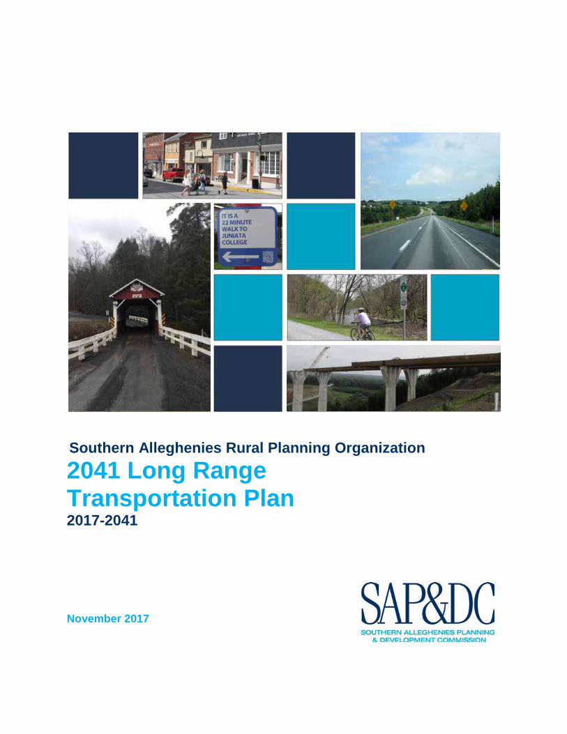
Southern Alleghenies Rural Planning Organization 2041 Long Range Transportation Plan 2017-2041
November 2017

This work was sponsored by the Pennsylvania Department of Transportation and Federal Highway Administration. The contents of this report reflect the views of the author(s), who is (are) responsible for the facts and accuracy of the data presented herein. The contents do not necessarily reflect the official views or policies of the Commonwealth of Pennsylvania, the United States Department of Transportation, or the Federal Highway Administration at the time of publication. This report does not constitute a standard, specification, or regulation.
Southern Alleghenies Rural Planning Organization (RPO)
2017-2041 Long Range Transportation Plan (LRTP)
Prepared by: Southern Alleghenies
Planning and Development Commission 3 Sheraton Drive
Altoona, Pennsylvania 16601-9343
Prepared for: Southern Alleghenies
Rural Planning Organization
Adopted on: November 2, 2017
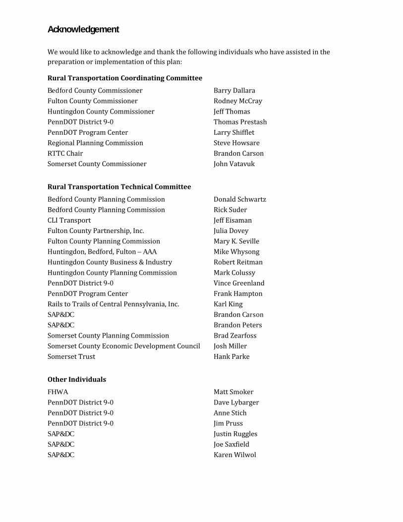
Acknowledgement
We would like to acknowledge and thank the following individuals who have assisted in the preparation or implementation of this plan:
Rural Transportation Coordinating Committee
Bedford County Commissioner Barry Dallara Fulton County Commissioner Rodney McCray Huntingdon County Commissioner Jeff Thomas PennDOT District 9-0 Thomas Prestash PennDOT Program Center Larry Shifflet Regional Planning Commission Steve Howsare RTTC Chair Brandon Carson Somerset County Commissioner John Vatavuk
Rural Transportation Technical Committee
Bedford County Planning Commission Donald Schwartz Bedford County Planning Commission Rick Suder CLI Transport Jeff Eisaman Fulton County Partnership, Inc. Julia Dovey Fulton County Planning Commission Mary K. Seville Huntingdon, Bedford, Fulton – AAA Mike Whysong Huntingdon County Business & Industry Robert Reitman Huntingdon County Planning Commission Mark Colussy PennDOT District 9-0 Vince Greenland PennDOT Program Center Frank Hampton Rails to Trails of Central Pennsylvania, Inc. Karl King SAP&DC Brandon Carson SAP&DC Brandon Peters Somerset County Planning Commission Brad Zearfoss Somerset County Economic Development Council Josh Miller Somerset Trust Hank Parke
Other Individuals
FHWA Matt Smoker PennDOT District 9-0 Dave Lybarger PennDOT District 9-0 Anne Stich PennDOT District 9-0 Jim Pruss SAP&DC Justin Ruggles SAP&DC Joe Saxfield SAP&DC Karen Wilwol
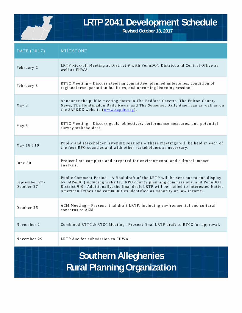
LRTP 2041 Development Schedule Revised October 13, 2017
DATE (2017) MILESTONE
Feb ruary 2 LR TP Kic k -o ff Mee t in g a t Distr ict 9 with Pe nn DO T Dis tr ict a nd Centra l O ff ice as wel l as FHW A .
Feb ruary 8 RTT C Meetin g – Di scus s steerin g com mittee , p la nned m ile sto nes , con dit ion o f regio na l tra ns portat io n faci l i t ie s , a nd upc omi ng l iste ni ng se ssi on s .
May 3An nou nce the pu bl ic me eting da tes in T he Bedf o rd Gazette , The Fu lt on County News , The Hu nti ngd on Dai ly Ne ws , a nd The So merset Dai ly Amer ican a s we ll as on the S AP &D C we bs ite ( w ww .sa pdc .or g) .
May 3 RTT C Meetin g – Di scus s goa ls , ob ject i ves , perfor mance measure s , an d po tent ia l survey sta keho lder s ,
May 18 &19 Pub lic a nd sta keho lder l isten in g sess io ns – Thes e meeti ng s wi l l be he ld i n each of the f our RPO c ount ies a nd w ith other sta keho ld ers a s neces sary .
June 30 Project l i sts c omp lete a nd prepare d for en viro n menta l a nd cu ltura l im p act analysi s .
Septem ber 27 - October 2 7
Pub lic Co mment Pe riod – A f ina l draf t of the LR TP wi l l be se nt out t o a n d d isp lay by S AP &D C (i nc ludi ng w ebsite , ) RPO c ounty pla nni ng c ommi ss ion s , a nd Penn DOT Dis tr ict 9 -0 . Add it io na l ly , the f ina l dra ft LRTP wi l l be mai led t o intere s ted Nat ive America n Tri bes a nd co mmunit ies ide nti f ied as minor ity or lo w i ncome .
October 2 5 A CM Meeti ng – Pre sent f ina l draft LR TP, inc lud i ng env iro nmen tal a nd c ultura l concer ns t o A CM.
Novem ber 2 Com bi ned R TT C & RT CC Meeti ng –Pre sent f ina l LRTP draf t t o RT CC f or a pprova l .
Novem ber 29 LR TP due for subm is sio n t o FHW A .
Southern Alleghenies Rural Planning Organization

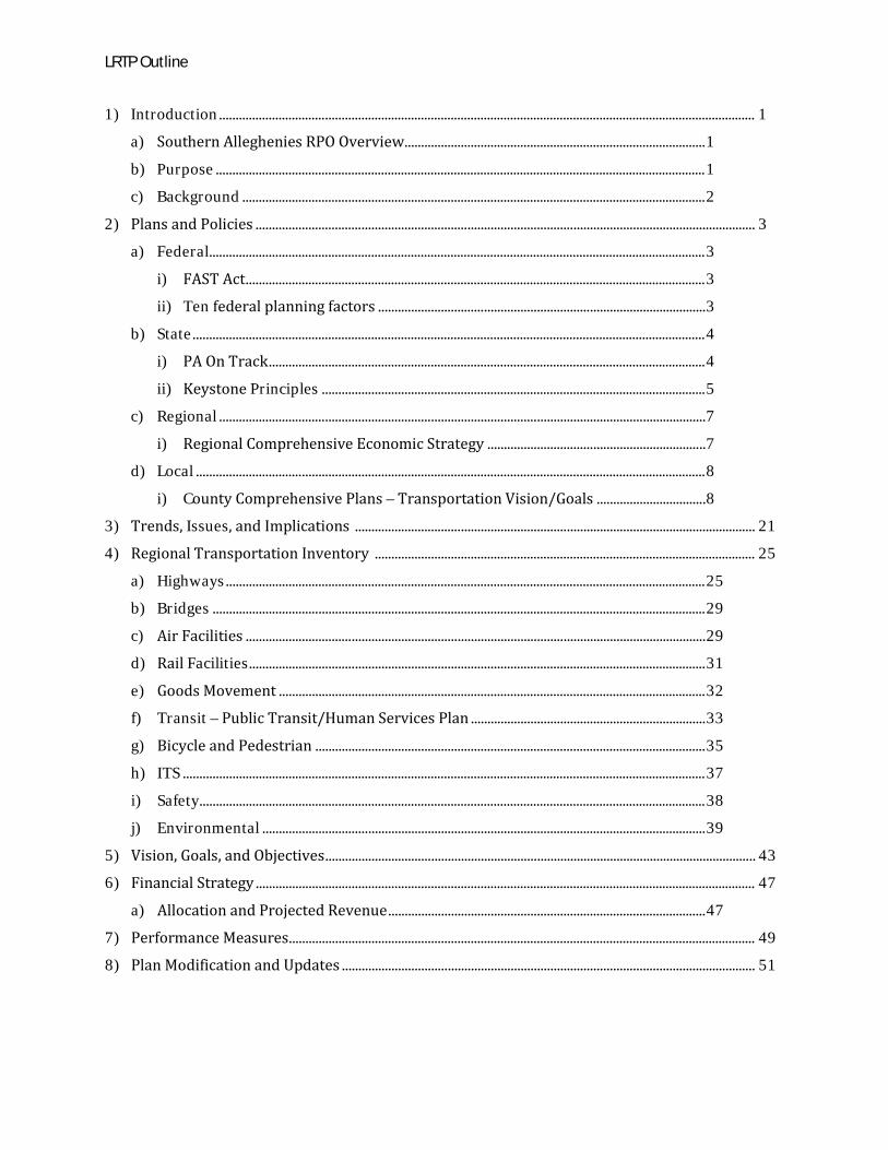
LRTP Outline
1) Introduction .................................................................................................................................................................. 1
a) Southern Alleghenies RPO Overview........................................................................................... 1
b) Purpose .................................................................................................................................................... 1
c) Background ............................................................................................................................................ 2
2) Plans and Policies ....................................................................................................................................................... 3
a) Federal...................................................................................................................................................... 3
i) FAST Act ........................................................................................................................................... 3
ii) Ten federal planning factors ................................................................................................... 3
b) State ........................................................................................................................................................... 4
i) PA On Track .................................................................................................................................... 4
ii) Keystone Principles .................................................................................................................... 5
c) Regional ................................................................................................................................................... 7
i) Regional Comprehensive Economic Strategy .................................................................. 7
d) Local .......................................................................................................................................................... 8
i) County Comprehensive Plans – Transportation Vision/Goals ................................. 8
3) Trends, Issues, and Implications ......................................................................................................................... 21
4) Regional Transportation Inventory ................................................................................................................... 25
a) Highways ................................................................................................................................................. 25
b) Bridges ..................................................................................................................................................... 29
c) Air Facilities ........................................................................................................................................... 29
d) Rail Facilities .......................................................................................................................................... 31
e) Goods Movement ................................................................................................................................. 32
f) Transit – Public Transit/Human Services Plan ....................................................................... 33
g) Bicycle and Pedestrian ...................................................................................................................... 35
h) ITS .............................................................................................................................................................. 37
i) Safety......................................................................................................................................................... 38
j) Environmental ...................................................................................................................................... 39
5) Vision, Goals, and Objectives .................................................................................................................................. 43
6) Financial Strategy ....................................................................................................................................................... 47
a) Allocation and Projected Revenue ................................................................................................ 47
7) Performance Measures............................................................................................................................................. 49
8) Plan Modification and Updates ............................................................................................................................. 51
LRTP Outline
Appendices
A. Southern Alleghenies RPO Policies and Procedures
B. Maps
C. Demographic Profile
D. Commuter Profile
E. Economic Profile
F. Projected Revenue
G. Project List
H. Illustrative Project List
I. Environmental Justice Summary
J. Public Involvement Summary
K. Public Participation Plan
L. Bicycle and Pedestrian Plan Executive Summary
M. Coordinated Transit-Human Services Plan Executive Summary
N. County Priorities
O. Implementation Matrix
Section 1: Introduction
_____________________________________________________________________________________ 1
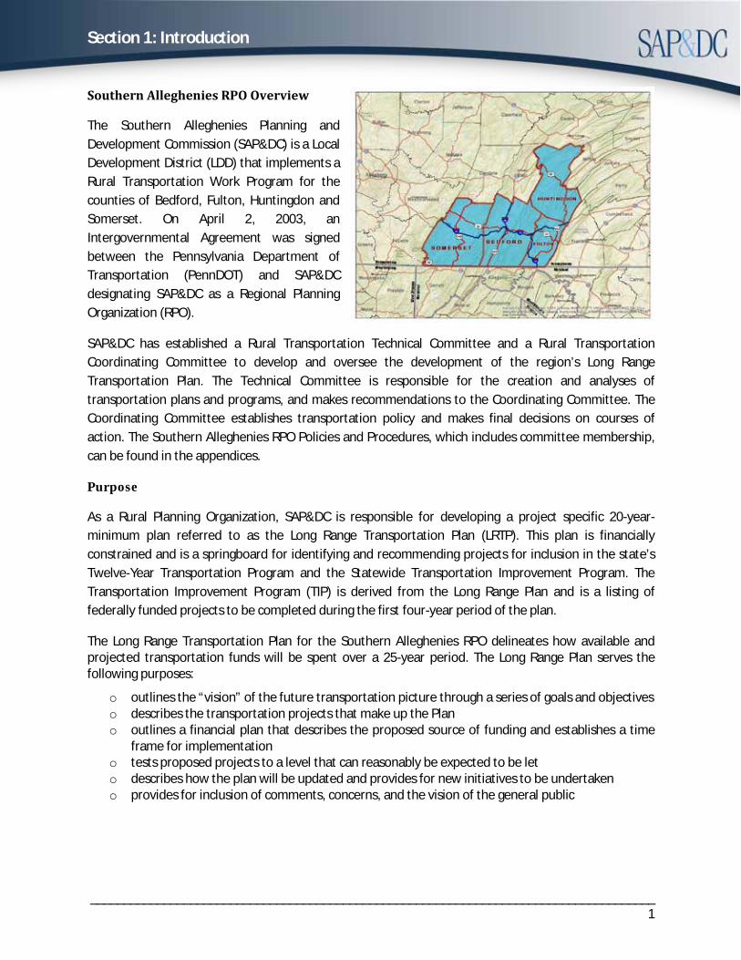
Southern Alleghenies RPO Overview
The Southern Alleghenies Planning and Development Commission (SAP&DC) is a Local Development District (LDD) that implements a Rural Transportation Work Program for the counties of Bedford, Fulton, Huntingdon and Somerset. On April 2, 2003, an Intergovernmental Agreement was signed between the Pennsylvania Department of Transportation (PennDOT) and SAP&DC designating SAP&DC as a Regional Planning Organization (RPO).
SAP&DC has established a Rural Transportation Technical Committee and a Rural Transportation Coordinating Committee to develop and oversee the development of the region’s Long Range Transportation Plan. The Technical Committee is responsible for the creation and analyses of transportation plans and programs, and makes recommendations to the Coordinating Committee. The Coordinating Committee establishes transportation policy and makes final decisions on courses of action. The Southern Alleghenies RPO Policies and Procedures, which includes committee membership, can be found in the appendices.
Purpose
As a Rural Planning Organization, SAP&DC is responsible for developing a project specific 20-year-minimum plan referred to as the Long Range Transportation Plan (LRTP). This plan is financially constrained and is a springboard for identifying and recommending projects for inclusion in the state’s Twelve-Year Transportation Program and the Statewide Transportation Improvement Program. The Transportation Improvement Program (TIP) is derived from the Long Range Plan and is a listing of federally funded projects to be completed during the first four-year period of the plan.
The Long Range Transportation Plan for the Southern Alleghenies RPO delineates how available and projected transportation funds will be spent over a 25-year period. The Long Range Plan serves the following purposes:
o outlines the “vision” of the future transportation picture through a series of goals and objectiveso describes the transportation projects that make up the Plano outlines a financial plan that describes the proposed source of funding and establishes a time
frame for implementationo tests proposed projects to a level that can reasonably be expected to be leto describes how the plan will be updated and provides for new initiatives to be undertakeno provides for inclusion of comments, concerns, and the vision of the general public
Section 1: Introduction
_____________________________________________________________________________________ 2
Background
Plan Development The Southern Alleghenies RPO 2017-2041 Long Range Transportation Plan (LRTP) was developed with the guidance of a steering committee comprised of local, regional, and statewide stakeholders. These stakeholders included county planning directors, PennDOT staff, Southern Alleghenies RPO staff, and regional rail and freight representatives. The steering committee provided input and assistance in the day-to-day development of the plan. Stakeholders were also contacted to provide information on various transportation modes including existing assets, historic trends, and future implications. Southern Alleghenies Rural Transportation Technical Committee and Rural Transportation Coordinating Committee provided regular guidance and input in the overall plan development including vision, goals, and objectives and project selection.
Public Involvement An extensive public involvement process, consistent with the Southern Alleghenies RPO Public Participation Plan, occurred over the development of the plan and prior to its adoption. During development of the plan, a series of listening sessions were held in each county to gather valuable input on the desired vision of the transportation network as well as to discuss any issues or projects that are important to the community. Additionally, an online and paper survey was conducted to gather input from the region. The input received at these meetings and via the survey was considered in developing the project list and the vision, goals, and objectives of the plan. The Regional Comprehensive Economic Development Strategy, county comprehensive plans, the FAST Act’s ten planning factors, the Keystone Principles, and the PA On Track were also considered in developing the plans vision, goals, and objectives.
A second public meeting was held to allow for comment on the draft plan during a 30-day public comment period. During this time, the plan was available for viewing at the four rural county planning commission offices, SAP&DC offices, and PennDOT District 9-0 as well as at www.sapdc.org.
The public involvement process and comments received are detailed in Appendix J of this document.
Section 2: Plans and Policies
_____________________________________________________________________________________3
2.a. Federal Plans and Policies
I. FAST Act The Fixing America’s Surface Transportation Act (FAST Act) was signed into law on December 4, 2015. The FAST Act authorizes $225.2 billion in funding for the Federal-aid highway programs through the year 2020. The FAST Act includes guidance for conducting long range transportation planning. It outlines eight federal planning factors from its predecessor and two new factors that must be considered in all long-range transportation plans.
a. Federal Planning Factors
The following Federal Planning Factors, identified in the FAST Act, were considered in the development of this plan:
1. Support the economic vitality of the metropolitan area, especially by enabling globalcompetitiveness, productivity, and efficiency.
2. Increase the safety of the transportation system for motorized and non-motorizedusers.
3. Increase security for transportation system users.
4. Increase the accessibility and mobility options available to people and for freight.
5. Protect and enhance the environment, promote energy conservation, improvequality of life, and promote consistency between transportation improvements andstate and local planned growth and economic development patterns.
6. Enhance the integration and connectivity of the transportation system, across andbetween modes, for people and freight.
7. Promote efficient system management and operation.
8. Emphasize preservation of the existing transportation system.
9. Improve the resiliency and reliability of the transportation system and reduce ormitigate stormwater impacts of surface Transportation.
10. Enhance travel and tourism.
Section 2: Plans and Policies
_____________________________________________________________________________________4
2.b. State Plans and Policies
II. PA On TrackPA On Track is Pennsylvania’s multimodal long range transportation plan and comprehensivefreight movement plan. The plan defines a transportation direction and establishestransportation priorities expressed through its goals and objectives. The predominant themes inthe plan are prioritization, projects, and system performance. The goals and objectives weredesigned to promote accessibility and connectivity for all modes of transportation, as well as toprovide tools to guide future transportation investment and ultimately improve the movementof people and goods.
System Preservation· Optimize pavement conditions· Reduce the number of structurally deficient bridges· Encourage state-of-good repair initiatives for all modes· Limit the number of load-restricted bridges
Safety · Reduce statewide transportation system fatalities· Reduce serious injury crashes statewide· Invest in cost-beneficial approaches and technologies that enhance the safety of the
transportation system· Improve public understanding of high-risk traveling behaviors· Reduce crashes, injuries, and fatalities in work zone areas· Promote, develop, and sustain multijurisdictional traffic incident management programs
to achieve enhanced responder safety, and safe and quick traffic incident clearance
Personal & Freight Mobility · Provide multimodal infrastructure and technology advancements to eliminate
bottlenecks and improve system efficiency and trip predictability · Increase access to jobs, labor, and transportation choices in urban, suburban, and rural
communities · Support communities through appropriate and equitable transportation modal options
and investments · Improve first and last mile intermodal access and connections· Improve bridge under-clearances and intersection geometry
Stewardship · Ensure a high standard of quality and maximize effectiveness of agency and user
investments · Enhance the performance of the transportation system while protecting the state’s
natural, cultural, and historic resources · Encourage the development and use of innovative technologies· Support transportation investments that reflect the diversity of Pennsylvanians and
their needs
Section 2: Plans and Policies
_____________________________________________________________________________________5
· Support coordination of land use and transportation planning· Support economic development· Support technical assistance/training courses offered to municipalities· Support clean air initiatives· Promote initiatives aimed at improving system operations and energy efficiency
III. Keystone Principles1. Redevelop first -- Support revitalization of Pennsylvania’s many cities and towns and give
funding preference to reuse and redevelopment of “brownfield” and previouslydeveloped sites in urban, suburban, and rural communities.
2. Provide efficient infrastructure -- Fix it first: use and improve existing infrastructure.Make highway and public transportation investments that use context sensitive design toimprove existing developed areas and attract residents and visitors to these places.Require private and public expansions of service to be consistent with approvedcomprehensive plans and consistent implementing ordinances.
3. Concentrate development -- Support infill and “greenfield” development that is compact,conserves land, and is integrated with existing or planned transportation, water and sewerservices, and schools. Foster creation of well-designed developments and neighborhoodsthat offer healthy life style opportunities for Pennsylvania residents.
4. Increase job opportunities -- Retain and attract a diverse, educated workforce throughthe quality of economic opportunity and quality of life offered in Pennsylvania’s variedcommunities. Integrate educational and job training opportunities for workers of all ageswith the workforce needs of businesses. Invest in businesses that offer good paying, highquality jobs; and that are located near existing or planned water & sewer infrastructure,housing, existing workforce, and transportation access (highway or transit).
5. Foster sustainable businesses -- Strengthen natural resource based businesses that usesustainable practices in energy production and use, agriculture, forestry, fisheries,recreation and tourism. Increase our supply of renewable energy. Reduce consumption ofwater, energy and materials to reduce foreign energy dependence and address climatechange.
6. Restore and enhance the environment -- Maintain and expand land, air and waterprotection and conservation programs. Conserve and restore environmentally sensitivelands and natural areas for ecological health, biodiversity and wildlife habitat.
7. Enhance recreational and heritage resources -- Maintain and improve recreational andheritage assets and infrastructure throughout the commonwealth, including parks andforests, greenways and trails, heritage parks, historic sites and resources, fishing andboating areas, and game lands offering recreational and cultural opportunities toPennsylvanians and visitors.
Section 2: Plans and Policies
_____________________________________________________________________________________6
8. Expand housing opportunities -- Support the construction and rehabilitation of housing ofall types to meet the needs of people of all incomes and abilities. Support local projectsthat are based on a comprehensive vision or plan, have significant potential impact (e.g.,increased tax base, private investment), and demonstrate local capacity, technical abilityand leadership to implement the project.
9. Plan regionally, implement locally -- Support multi-municipal county and localgovernment planning and implementation that has broad public input and support, and isconsistent with these principles. Provide education, training, technical assistance, andfunding for such planning and for transportation, infrastructure, economic development,housing, mixed use and conservation projects that implement such plans.
10. Be fair -- Support equitable sharing of the benefits and burdens of development. Providetechnical and strategic support for inclusive community planning to ensure social,economic, and environmental goals are met.
Section 2: Plans and Policies
_____________________________________________________________________________________7
2.c. Regional Plans and Policies
Southern Alleghenies Comprehensive Economic Development Strategy
Goal 1: Seek Expansion of the Regional Economy through Diversified Job Growth
Objective A: Continue the gradual movement of the Region to a more technology-related, diversified economy.
Objective B: Create an entrepreneurial environment to support start-up enterprises and strengthen existing businesses.
Objective C: Expand the tourism visitation potential for the Region.
Objective D: Provide services and amenities intended to attract the retired (or near-retired) households.
Goal 2: Maintain and Modernize Infrastructure to Make the Region More Competitive for Economic Development
Objective A: Upgrade and expand telecommunications service in the Region.
Objective B: Improve the transportation network to tie the Region together and make the Region more accessible to other markets
Objective C: Upgrade water/sewer infrastructure to accommodate new and modern growth.
Goal 3: Adapt Communities to be More Attractive to Young People as Places to Live and Work
Objective A: Market the region as an exciting outdoor playground for young adults.
Objective B: Support innovative entrepreneurial initiatives that are designed to attract young creative-class professionals to downtown areas.
Objective C: Develop increased opportunities for distance employment for younger workers in the Region.
Objective D: Improve the appearance, livability, and economic viability of downtowns.
Objective E: Increase opportunities for graduate and post-graduate education.
Goal 4: Support the Growth of Local Agriculture-Related Business
Objective A: Support the growth of value-added agriculture through technical assistance and financial lending programs.
Objective B: Support the expansion of direct markets for locally grown food.
Section 2: Plans and Policies
_____________________________________________________________________________________8
2.d. Local Plans and Policies
County Comprehensive Plans
The county comprehensive plans are the most up-to-date plans on file with the county planning commissions at the writing of this LRTP. A six county, including the four RPO counties, Comprehensive Plan is underway and expected to be adopted in early 2018. Each of the counties’ transportation plans will be updated through that effort.
Bedford County Transportation Plan
The Transportation Plan for Bedford County reflects the County’s reliance on the roadway network for both personal and business travel as well as goods movement; Bedford County has more miles of interstate roadway than any other county in the Southern Alleghenies planning region. It also supports the expansion of pedestrian and bicycle routes within and between communities and recommendations for enhancing aviation facilities.
Goal 4: Provide a well-maintained transportation system that supports safe and efficient movement of people, goods and services throughout the County.
Objective 4.1: Complete existing and planned transportation projects that will address the safety, mobility and betterment of roads and bridges in Bedford County.
Action 4.1.1: Work cooperatively through the Southern Alleghenies Rural Planning Organization to evaluate and program, every two years, state and local roadway and bridge projects in the State Twelve Year Transportation Plan.
Action 4.1.2: Encourage municipalities to include access management techniques and requirements in their subdivision and land development policies.
Action 4.1.3: Promote traffic calming measures in boroughs and villages experiencing growth in traffic congestion.
Objective 4.2: Monitor service levels on secondary rural roadways throughout the county and develop an improvement strategy. Bedford County is highly dependent upon roadways for commutation and goods movement. Results from the community survey indicate that over 65 percent of survey respondents agreed that the improvement and maintenance of township and borough roads throughout the county were needed. While the maintenance and operation of local roads is primarily a municipal function, this was the highest such public preference indicated on all survey questions related to Bedford County transportation.
Action 4.2.1: Identify rural state roads that could be turned back to local municipalities for on-going maintenance. Discuss with local officials the benefits of the turn back program. PennDOT’s Local Technical Assistance Program (LTAP) is the mechanism for seeking a turn-back arrangement.
Section 2: Plans and Policies
_____________________________________________________________________________________9
Action 4.2.2: Assess the level of interest in the use fuel tax revenues to jointly purchase municipal road maintenance equipment and materials. Work with municipalities interested in establishing a joint purchasing program. PennDOT ‘s Agility Program can supplement this process.
Action 4.2.3: Explore the creation of a program to provide local matching monies for road and bridge improvements. Federal Critical Bridge funds are not eligible to be used on local bridges less than 20 feet in length. This has been a significant burden for local municipalities to handle in addressing their bridge needs. Municipalities also commonly need assistance in working through the local bridge delivery process with PennDOT, including issues related to environmental and right of way clearance, consultant agreement and others.
Action 4.2.4: Encourage municipalities to include the functional classification of roads as part of their municipal comprehensive plan.
Action 4.2.5: Encourage the establishment of a regional position for contract administration of local bridge projects.
Action 4.2.6: Promote inter-municipal cooperation for road and bridge maintenance and related equipment.
Objective 4.3: Promote public transportation services, especially to meet the needs of senior citizens and disabled residents. Nearly half of all survey respondents (45 percent) indicated that the availability of public transportation services throughout the county is currently inadequate. In another example, certain services, such as shuttle bus service to other regional destinations, such as Altoona and Cumberland, MD were projects that survey respondents felt should be pursued by the county.
Action 4.3.1: Explore the possibility of bus, mini-bus, and/or taxi service between community centers or events. Coordinate transit schedules with event schedules.
Action 4.3.2: Advocate Bedford County's participation in the "Persons with Disabilities" program. This program provides subsidized, demand-responsive service to rural areas of Pennsylvania. The County's aging population also dictates that an emphasis be placed on alternative forms of transportation for the County's elderly who live in rural areas away from needed medical care and services.
Objective 4.4: Promote the development and use of bicycle and pedestrian facilities and resources.
Action 4.4.1: Promote safe pedestrian and bicycle travel that interconnects neighborhoods, community facilities and services. Encourage construction and maintenance of bicycle trails and routes, sidewalks, hiking trails and street-crossing facilities that connect downtowns.
Action 4.4.2: Encourage municipalities to submit candidate projects for consideration in such programs as PennDOT's Transportation Enhancement Program and Hometown Streets/Safe Routes to School Program.
Section 2: Plans and Policies
_____________________________________________________________________________________10
Action 4.4.3: Encourage county municipalities with land use management tools to require bicycle parking facilities as part of their ordinances for new commercial land development.
Action 4.4.4: Develop a countywide priority bicycle/pedestrian network map for use in planning and prioritizing bicycle and pedestrian facilities.
Objective 4.5: Support appropriate land development practices with respect to the county's airport. Bedford County's general aviation airport is strategically located at the crossroads of I-70, I-76, I-99 and US 30. The airport has already obtained land for a future runway expansion. The completion of a second business park (coupled with developments at the Bedford Springs Hotel Resort complex) should see additional enplanements at the facility.
Action 4.5.1: Continue to support on-going improvements related to security and expansion (ramps, corporate hangers, etc.) at the Bedford County Airport. Assist with local matching dollars where possible. PennDOT's Bureau of Aviation administers three grant programs for airport development: the Block Grant Program (BGP, federal), the Aviation Development Program (ADP, state) and the Capital Budget/Transportation Assistance Program (TAP, state), amounting to approximately $20 million annually. The Block Grant Program is available only to general aviation airports, airports designated as reliever airports, and non-primary commercial airline airports (those with fewer than 10,000 annual enplaned passengers) that are part of the National Plan of Integrated Airport System (NPIAS), as approved by the FAA. Airports receive up to 95 percent of eligible project costs for projects included in the State's 12 Year Transportation Program.
Action 4.5.2: Promote policies that benefit air carriers and the local businesses that are dependent on aviation services.
Action 4.5.3: Encourage the airport authority to use PennDOT's Agility Program for purposes of snow removal for its additional taxiway and runway.
Action 4.5.4: Promote the importance of the airport as an economic development asset for Bedford County businesses.
Section 2: Plans and Policies
_____________________________________________________________________________________11
Fulton County Transportation Plan
As the region grows over this comprehensive plan’s planning period, transportation and land use must be linked together so as to maintain and increase the quality of life within the region. Most of the communities within the region have appropriate ingredients to create transit-oriented communities, since all of them were built prior to the widespread use of the automobile. Walking was a necessity and a primary mode of travel and the sidewalks, trails and streets that provided local connections are still intact. What the region’s communities lack are a regional network of connections.
The hamlets/villages and town center future land uses need to be the hubs of a regional transportation network. By doing so, the rural resource area will be protected from future growth. These future land use areas provide the best opportunities for transportation investment.
The following section provides an implementation table for the region to consider for its regional transportation needs:
Goal: Educate residents, developers, and local officials on key regional transportation initiatives.
Objective: Through education, local officials, Building Associations and Fulton County Planning Commission can make better decisions and respond faster to changes.
Actions: · Annually review transportation projects to determine priority status.· Work with the local newspapers to publish transportation updates.· Place transportation projects and updates on the County web site.
Goal: Utilize the growth management strategy as the framework for providing the desired transportation infrastructure patterns and investments.
Objective: · Plan for 90% of the region’s transportation infrastructure growth to occur in the
designated growth area. · Plan for the remaining 10% of the region’s transportation infrastructure growth to occur
in the rural resource areas.
Actions: · Prioritize all investments for transportation infrastructure on how they will affect
growth within the Region. · Utilize the Official Map and DGA Master Plans to control future transportation
infrastructure investments.
Section 2: Plans and Policies
_____________________________________________________________________________________12
Goal: Foster mixed-use and walkable neighborhoods to encourage alternative modes of transportation in designated growth areas.
Objective: · Enhances Air Quality· Enhances Existing Roadway Capacities
Actions: · Develop Master Plans within the DGA that consider alternative modes of
transportation. · Adopt mixed use neighborhood design tools and incentives to help maintain and
shape the physical character of neighborhoods. · Require sidewalks and bikeways in existing ordinances.
Goal: Promote the creation of a park and ride facility along Interstate 70.
Objective: · Enhances Air Quality· Enhances Existing Roadway Capacities
Actions: Fulton County Planning Commission to facilitate a discussion to determine viability of constructing a park and ride facility along Interstate 70.
Goal: Encourage modern transportation planning practices within the Region.
Objective: Enhance transportation infrastructure concurrent with growth
Actions: · Update local subdivision and land development ordinances to include access
management, improved parking strategies, traffic calming, and other recommendations within this Chapter.
· Utilize the Official Map to protect right-of-ways for new street, sidewalk, and trailconnections.
· Develop Master Plans for each of the DGA areas focusing on establishing gatewaysand identifiable themes.
Goal: Develop a regional capital improvements and maintenance program.
Objective: Through the cooperation with other municipalities, the Region will witness improved road and bridge maintenance and capital investments.
Actions: · The Council of Government should determine regional maintenance needs and
prioritize and facilitate the completion of these efforts. · The Council of Government should determine regional capital improvement needs
and prioritize and facilitate the completion of these efforts.
Section 2: Plans and Policies
_____________________________________________________________________________________13
Goal: Initiate transit considerations within and outside the region.
Objective: · To stimulate economic growth.· Enhance roadway capabilities.· Promote alternatives to travel.
Actions: · Encourage design that considers transit.· Update County subdivision and land development ordinances to contain transit
oriented initiatives.· Encourage a mix of residential and non-residential uses.
Summary
The County’s transportation infrastructure is adequate to serve the existing and proposed population outlined within this plan with routine maintenance. However, the Region must be cognizant of the importance to balance land use and transportation needs. For if one of the two would experience significant growth over the plan period it will directly impact the other. Therefore, this Chapter has suggested methods to achieve concurrent infrastructure investment with development investment.
Section 2: Plans and Policies
_____________________________________________________________________________________14
Huntingdon County Transportation Plan
Goal: While Retaining Its Rural and Small-Town Atmosphere, Huntingdon County Will Remain Accessible to Pennsylvania and the Rest of the World. Information, Goods, and Services Will Travel to and Within Huntingdon County by a Complete Network of Highway, Rail, and Electronic Modes.
OBJECTIVE: Plan for a high-quality arterial highway system that serves to connect Huntingdon County with the rest of the world. POLICIES:
1. Promote free-flowing traffic on arterials by promoting sound design standards and avoiding excessive strip development.
2. Support limiting new access onto arterial roads through the PennDOT driveway permit process.3. Focus State and Federal financial assistance on arterial highway needs.4. Support the development of secondary (marginal) access roads to minimize entrance to arterial
roads.5. Encourage a key rural access management concept for Routes 26, 22, and 522, including the
purchase of scenic easements and limited frontage access.
OBJECTIVE: Participate fully in the highway planning process, as a part of the Southern Alleghenies Rural Planning Organization (RPO), to make highway improvements for safety and economic development.
POLICIES:
1. Coordinate transportation and land use planning to protect against unintended development impacts.
2. Develop information on the transportation planning process for dissemination to local officials andcitizens, in cooperation with PennDOT and Southern Alleghenies Planning and Development Commission.
3. Coordinate both public and private actions in support of transportation improvements, includingparticipation in the transportation planning process.
4. Continue offering testimony to PennDOT and the regional planning agency to support the decision-making process.
5. Develop a County-level Transportation Information System.
Section 2: Plans and Policies
_____________________________________________________________________________________15
OBJECTIVE: Support the design of collector and local streets consistent with the nature and future land use of the community.
POLICIES:
1. Encourage an appropriate standard for new rural roads in low intensity areas through subdivision and land development ordinances. At the same time, discourage excessive highway standards(excessive street widths, unnecessary curbing, overuse of cul-de-sacs, etc.)
2. Discourage strip commercial development in local zoning.3. Support intersection improvements and realignments for traffic safety.
OBJECTIVE: Encourage the development of sustainable alternatives to auto travel throughout Huntingdon County.POLICIES:
1. Support at least three Amtrak rail passenger trains to Huntingdon from both directions every day.2. Support improved rail freight service through restoration of existing Smithfield TownshipFairgrounds Road and former EBT in Mt. Union and Shirley Township siding and creation of a transload facility.
3. Encourage the restoration of the East Broad Top Railroad (EBT) for tourism.4. Examine the need for regular bus service to neighboring counties and taxi service.5. Encourage paved shoulders and line striping where appropriate as lanes for pedestrian
non-motorized traffic.6. Encourage the requirement of sidewalks for new development in designated urban or suburban
areas.
OBJECTIVE: Improve access to Raystown Lake and associated recreation areas.
POLICIES:
1. Support better access to the Raystown Lake area through upgrading State and local2. Assist local municipalities in obtaining funding to upgrade Raystown access roads.
Section 2: Plans and Policies
_____________________________________________________________________________________16
Somerset County Transportation Plan
County Vision: · U.S. 219 needs to be completed between Somerset and the Meyersdale Bypass and
Maryland I-68. This will provide a crucial north-south transportation corridor in the county, improving the safety, mobility, and economic viability of the overall county. Community and political support needs to be organized to ensure this remains a funding priority.
· A Somerset Area Comprehensive Traffic and Circulation Study should be performed. Thestudy would identify congestive areas for traffic mitigation in Somerset Borough andTownship and consider them in the context of the travel needs of the entire Somersetarea. This would also address future impacts from the completion of U.S. 219 and accessto the growing industrial area on the eastern edge of Somerset. It could assess extendingPleasant Avenue around the Borough and possible interchanges between the Turnpike atU.S. 219, and/or P.A. 31.
· Community and political support needs to be organized to ensure that U.S. 30 and P.A.160 receive high priority for improvement. Improvements at key intersections throughoutthe County need to be forwarded through the County’s Transportation ImprovementProgram and PENNDOT.
· Promote the current initiative to construct an Amtrak passenger rail station in Rockwood.Rockwood is strategically located in a major recreation destination region—a haven forskiers and cyclists. The station would attract visitors from the Washington D.C./Baltimorearea and improve access for residents of Somerset County. However, the passenger railcompany has to be assured of a financially successful venture before it can commit.
· New transportation projects should employ PENNDOT’s new Context-Sensitive Designstrategies. As the new sections of U.S. 219 are planned, context-sensitive design elementsshould be employed to buffer the roadway from scenic views, bridges, and otherstructures. This could be accomplished by the treatment of stone form liners on bridgeabutments, and gateway landscape treatments could be developed to purvey a sense ofquality and local character.
County Goals · Organize to ensure that Route 219 receives funding and approvals for completion
· Develop a comprehensive transportation infrastructure strategy for the Somerset AreaØ Address Turnpike Interchange areaØ Create access management strategy for Route 601 North.Ø Improve linkages between Routes 31, 219 and the TurnpikeØ Extend Pleasant Ave. (Gilmour Bypass) to Edgewood Ave.
· Develop the Amtrak station in RockwoodØ Provides a new opportunity for tourism accessibility, especially to one of the County’s
key markets, the Washington, D.C./Baltimore area
Section 2: Plans and Policies
_____________________________________________________________________________________17
Ø Creates a major boost to Rockwood’s fledgling reinvestment initiative Ø Treat the station area as a gateway to the region - create an attractive parking area with
landscaping, etc.
Action Plan The Transportation Action Plan focuses on providing a basic framework to meet the existing and future transportation needs of its citizens. It will serve as a useful guide to Somerset County in their efforts to program future transportation improvement projects. The key components of the Plan are the transportation improvement recommendations and Transportation Map. Together, these instruments will help meet the transportation needs of existing and future development.
GOAL: To provide an efficient and well maintained transportation system to maximize the accessibility and safe movement of people and goods through cooperative transportation planning with local governments, SCEDC, and the Commonwealth of Pennsylvania.
Objective: Ensure the completion of existing and planned highway projects that will increase mobility through and throughout Somerset County.
Policy: Provide community support and financial funding of highway projects, while promoting recognition with state and federal officials that highway improvements and completion are a high priority.
Action Strategies · Ensure that U.S. Route 219 receives funding and approvals for completion – Complete
U.S. 219 between Somerset and the Meyersdale Bypass. · Complete north-south countywide access to the Route 31/Route 219 Interchange· Construct U.S. 219 between Meyersdale and I-68 in Maryland. This will provide regional
inbound and outbound access.· Ensure that any reconstruction of the Pennsylvania Turnpike service plaza facilities does
not hinder incoming and outgoing travel from the Borough of Somerset.
Methods, Tools, and References · GIS Mapping
Partners and Funding Sources PennDOT, Pennsylvania Turnpike Commission, Southern Alleghenies Planning and Development Commission, Somerset County Commissioners, Somerset County Chamber of Commerce, and Continental One
Priority Level: High
Section 2: Plans and Policies
_____________________________________________________________________________________18
Objective: Continue to provide a countywide transportation-planning program to improve identified intersections and roadways.
Policy: Work with state and federal government officials to identify and program transportation system improvements.
Action Strategies · Prioritize improvements, including those called for on the Transportation Improvement
Program. · Maintain and improve physical transportation infrastructure with focus on addressing
priority projects that link communities with regional roadway networks.
Methods, Tools, and References · Transportation Improvement Program
Partners and Funding Sources PennDOT, Southern Alleghenies Planning and Development Commission, Somerset County Commissioners, Somerset County Planning Commission.
Priority Level: Medium-High
Objective: Relieve traffic congestion throughout the roadway network to improve commute and freight movement, air quality, and overall quality of life.
Policy: Develop a transportation infrastructure strategy for the Somerset Area.
Action Strategies: · Implement an access management strategy and signalization reduction and loop system
along Route 601 North. · Support the proposed Somerset Area Comprehensive Traffic Relief/Circulation Study.· Study the creation of a Route 219, route 31 and Pennsylvania Turnpike EZPass slip-ramp
interchange
Methods, Tools, and References · GIS Mapping· Somerset Area Traffic Study
Partners and Funding Sources PennDOT, Somerset County Planning Commission, Pennsylvania Turnpike Authority, Southern Alleghenies Planning and Development Commission, Somerset County Chamber of Commerce, Somerset Borough, Somerset Township, Somerset Inc.
Priority Level: High
Section 2: Plans and Policies
_____________________________________________________________________________________19
Objective: Encouraging alternative transportation forms by creating livable communities through the implementation of walkable villages and transit-oriented development.
Policy: Provide pedestrian infrastructure in downtown areas, as well as facilitate non-vehicular forms of transportation throughout Somerset County.
Action Strategies · Promote the concept of “Trail Towns” along the Allegheny Trail· Encourage offshoots of other inter-County trails from the Allegheny Highlands Trail/Great
Allegheny Passage Trail· Involve more economic stakeholders in the negotiations with Amtrak to construct a
passenger rail stop in Rockwood.
Methods, Tools, and References · GIS Mapping· Identifying signage· Strategic negotiating skills
Partners and Funding Sources Pennsylvania Rails to Trails Conservancy, Amtrak, Allegheny Trail Alliance, Somerset County Rails to Trails Association, Main Street programs, downtown business districts
Priority Level: Medium-Low
Section 2: Plans and Policies
_____________________________________________________________________________________20
Page intentionally left blank
Section 3: Trends, Issues, and Implications
________________________________________________________________________________________________21
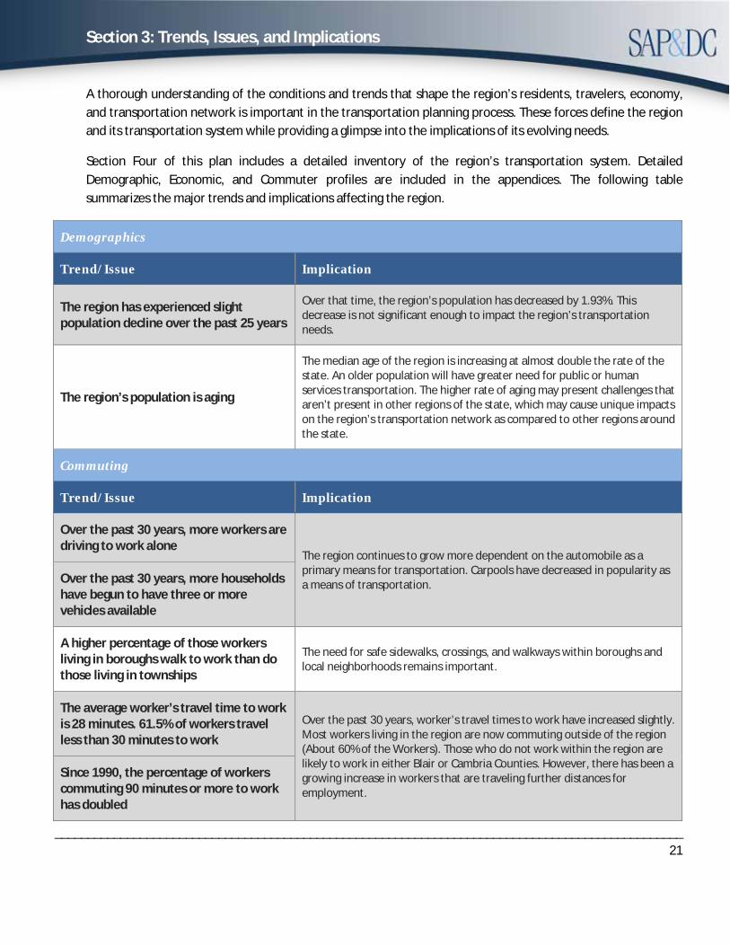
A thorough understanding of the conditions and trends that shape the region’s residents, travelers, economy, and transportation network is important in the transportation planning process. These forces define the region and its transportation system while providing a glimpse into the implications of its evolving needs.
Section Four of this plan includes a detailed inventory of the region’s transportation system. Detailed Demographic, Economic, and Commuter profiles are included in the appendices. The following table summarizes the major trends and implications affecting the region.
Demographics
Trend/Issue Implication
The region has experienced slight population decline over the past 25 years
Over that time, the region’s population has decreased by 1.93%. This decrease is not significant enough to impact the region’s transportation needs.
The region’s population is aging
The median age of the region is increasing at almost double the rate of the state. An older population will have greater need for public or human services transportation. The higher rate of aging may present challenges that aren’t present in other regions of the state, which may cause unique impacts on the region’s transportation network as compared to other regions around the state.
Commuting
Trend/Issue Implication
Over the past 30 years, more workers are driving to work alone
The region continues to grow more dependent on the automobile as a primary means for transportation. Carpools have decreased in popularity as a means of transportation. Over the past 30 years, more households
have begun to have three or more vehicles available
A higher percentage of those workers living in boroughs walk to work than do those living in townships
The need for safe sidewalks, crossings, and walkways within boroughs and local neighborhoods remains important.
The average worker’s travel time to work is 28 minutes. 61.5% of workers travel less than 30 minutes to work
Over the past 30 years, worker’s travel times to work have increased slightly. Most workers living in the region are now commuting outside of the region (About 60% of the Workers). Those who do not work within the region are likely to work in either Blair or Cambria Counties. However, there has been a growing increase in workers that are traveling further distances for employment.
Since 1990, the percentage of workers commuting 90 minutes or more to work has doubled
Section 3: Trends, Issues, and Implications
________________________________________________________________________________________________22
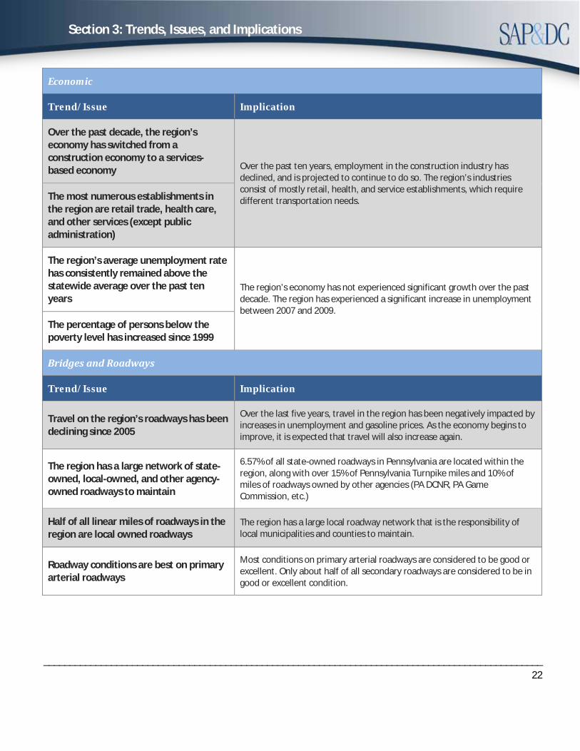
Economic
Trend/Issue Implication
Over the past decade, the region’s economy has switched from a construction economy to a services-based economy Over the past ten years, employment in the construction industry has
declined, and is projected to continue to do so. The region’s industries consist of mostly retail, health, and service establishments, which require different transportation needs. The most numerous establishments in
the region are retail trade, health care, and other services (except public administration)
The region’s average unemployment rate has consistently remained above the statewide average over the past ten years
The region’s economy has not experienced significant growth over the past decade. The region has experienced a significant increase in unemployment between 2007 and 2009.
The percentage of persons below the poverty level has increased since 1999
Bridges and Roadways
Trend/Issue Implication
Travel on the region’s roadways has been declining since 2005
Over the last five years, travel in the region has been negatively impacted by increases in unemployment and gasoline prices. As the economy begins to improve, it is expected that travel will also increase again.
The region has a large network of state-owned, local-owned, and other agency-owned roadways to maintain
6.57% of all state-owned roadways in Pennsylvania are located within the region, along with over 15% of Pennsylvania Turnpike miles and 10% of miles of roadways owned by other agencies (PA DCNR, PA Game Commission, etc.)
Half of all linear miles of roadways in the region are local owned roadways
The region has a large local roadway network that is the responsibility of local municipalities and counties to maintain.
Roadway conditions are best on primary arterial roadways
Most conditions on primary arterial roadways are considered to be good or excellent. Only about half of all secondary roadways are considered to be in good or excellent condition.
Section 3: Trends, Issues, and Implications
________________________________________________________________________________________________23
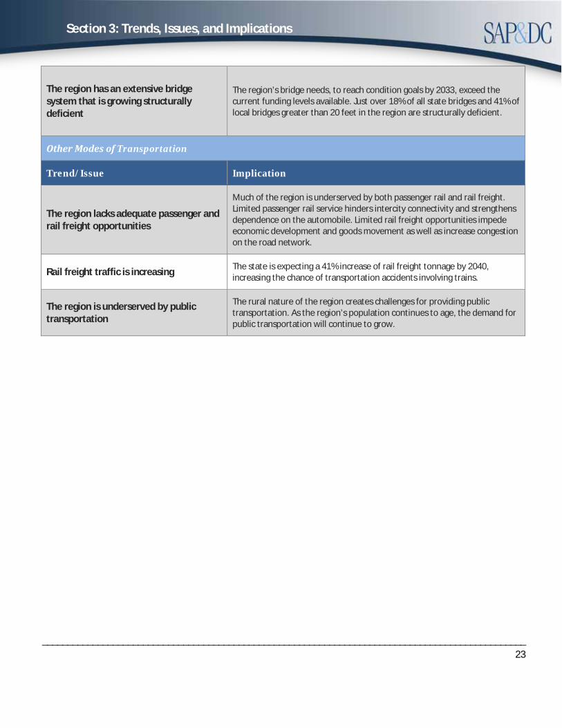
The region has an extensive bridge system that is growing structurally deficient
The region’s bridge needs, to reach condition goals by 2033, exceed the current funding levels available. Just over 18% of all state bridges and 41% of local bridges greater than 20 feet in the region are structurally deficient.
Other Modes of Transportation
Trend/Issue Implication
The region lacks adequate passenger and rail freight opportunities
Much of the region is underserved by both passenger rail and rail freight. Limited passenger rail service hinders intercity connectivity and strengthens dependence on the automobile. Limited rail freight opportunities impede economic development and goods movement as well as increase congestion on the road network.
Rail freight traffic is increasing The state is expecting a 41% increase of rail freight tonnage by 2040, increasing the chance of transportation accidents involving trains.
The region is underserved by public transportation
The rural nature of the region creates challenges for providing public transportation. As the region’s population continues to age, the demand for public transportation will continue to grow.

Section 3: Trends, Issues, and Implications
________________________________________________________________________________________________24
Page intentionally left blank

Section 4: Regional Transportation Inventory
______________________________________________________________________________25
Importance of the Region’s Major Highway Network to Economic Development
The Southern Alleghenies Rural Planning Organization (RPO) region encompasses a vast network of transportation infrastructure important to the region, the state, and the nation. This infrastructure includes highways, airports, railroads, public transit, and bicycling and pedestrian. The region also provides a wide range of recreational sites, tourism attractions, employment centers, and transportation facilities. The transportation infrastructure must support these assets. The following is a summary of the transportation modes within the Southern Alleghenies RPO.
Highways
The highway system within the Southern Alleghenies RPO is strategically located between major urban areas of Pittsburgh, Harrisburg, and Washington D.C. Major east-west transportation corridors servicing the area include the Pennsylvania Turnpike, U.S. 30, and U.S. 22. Major north-south corridors consist of Interstate 70, U.S. 219, U.S. 220, Interstate 99 and U.S. 522. The region also possesses a multitude of two lane state and local roads that have a regional significance.
2015 Linear Mileage
COUNTY PENNDOT
LINEAR MILES
OTHER AGENCIES
LINEAR MILES*
TURNPIKE LINEAR MILES
LOCAL MUNICIPAL
LINEAR MILES
TOTAL LINEAR MILES
05 BEDFORD 793.54 33.80 35.33 918.14 1,780.81 29 FULTON 340.31 3.40 19.11 323.38 686.20 31 HUNTINGDON 598.56 63.12 2.50 632.65 1,296.83 55 SOMERSET 880.47 26.74 29.85 1,267.40 2,204.46
TOTAL 2,612.88 127.06 86.79 3141.57 5,968.30
% of State 6.58% 16.3% 15.7% 4.02% 4.97% Source: Pennsylvania Highway Statistics 2015 *Includes other state and federal agencies such as State Universities, DCNR, Department of Health, Department of Education, National Parks, and US Forest Service
The Southern Alleghenies RPO has a total of 5,968.30 linear miles of roadway. Nearly 6.0% of those miles are part of the National Highway System. Roadways in the region that are a part of the National Highway System (NHS) include U.S. 30, U.S. 22, U.S. 219, U.S. 220, U.S. 522, Pennsylvania Turnpike, Interstate 70, Interstate 99, and State Route 56. Approximately 19% of the total linear miles of roadway in the region are part of the Federal Aid System. The region’s roadways account for 5.0% of the total linear miles of roadway in the state.
The region’s highway network serves a variety of travel types including commuters, goods movement, long-distance “through” travel, and recreational travel. In 2015 the region’s roadways (excluding locally-owned roadways) had an average daily vehicle miles traveled (DVMT) of nearly 7.0 million miles. This accounts for 3.03% of the total DVMT (excluding locally-owned roadways) in the state. Since 2009 the DVMT for the region has decreased 4.25%. The region has experienced a higher than average decrease in DVMT compared with statewide figures, which indicate a statewide decrease in DVMT over the same time period of only -2.30%.
Section 4: Regional Transportation Inventory
______________________________________________________________________________26
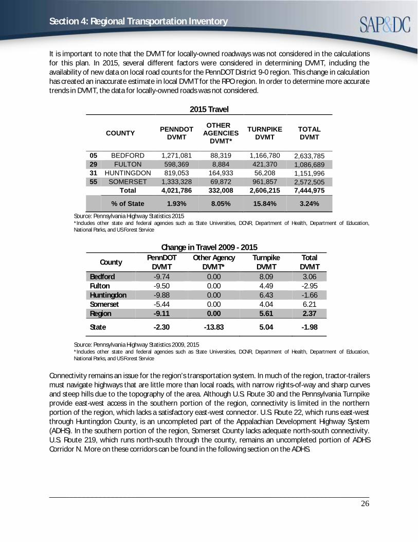
It is important to note that the DVMT for locally-owned roadways was not considered in the calculations for this plan. In 2015, several different factors were considered in determining DVMT, including the availability of new data on local road counts for the PennDOT District 9-0 region. This change in calculation has created an inaccurate estimate in local DVMT for the RPO region. In order to determine more accurate trends in DVMT, the data for locally-owned roads was not considered.
2015 Travel
COUNTY PENNDOT DVMT
OTHER AGENCIES
DVMT* TURNPIKE
DVMT TOTAL DVMT
05 BEDFORD 1,271,081 88,319 1,166,780 2,633,785 29 FULTON 598,369 8,884 421,370 1,086,689 31 HUNTINGDON 819,053 164,933 56,208 1,151,996 55 SOMERSET 1,333,328 69,872 961,857 2,572,505
Total 4,021,786 332,008 2,606,215 7,444,975
% of State 1.93% 8.05% 15.84% 3.24% Source: Pennsylvania Highway Statistics 2015 *Includes other state and federal agencies such as State Universities, DCNR, Department of Health, Department of Education,National Parks, and US Forest Service
Change in Travel 2009 - 2015
Source: Pennsylvania Highway Statistics 2009, 2015 *Includes other state and federal agencies such as State Universities, DCNR, Department of Health, Department of Education,National Parks, and US Forest Service
Connectivity remains an issue for the region’s transportation system. In much of the region, tractor-trailers must navigate highways that are little more than local roads, with narrow rights-of-way and sharp curves and steep hills due to the topography of the area. Although U.S. Route 30 and the Pennsylvania Turnpike provide east-west access in the southern portion of the region, connectivity is limited in the northern portion of the region, which lacks a satisfactory east-west connector. U.S. Route 22, which runs east-west through Huntingdon County, is an uncompleted part of the Appalachian Development Highway System (ADHS). In the southern portion of the region, Somerset County lacks adequate north-south connectivity. U.S. Route 219, which runs north-south through the county, remains an uncompleted portion of ADHS Corridor N. More on these corridors can be found in the following section on the ADHS.
County PennDOT DVMT
Other Agency DVMT*
Turnpike DVMT
Total DVMT
Bedford -9.74 0.00 8.09 3.06 Fulton -9.50 0.00 4.49 -2.95 Huntingdon -9.88 0.00 6.43 -1.66 Somerset -5.44 0.00 4.04 6.21 Region -9.11 0.00 5.61 2.37
State -2.30 -13.83 5.04 -1.98
Section 4: Regional Transportation Inventory
______________________________________________________________________________27
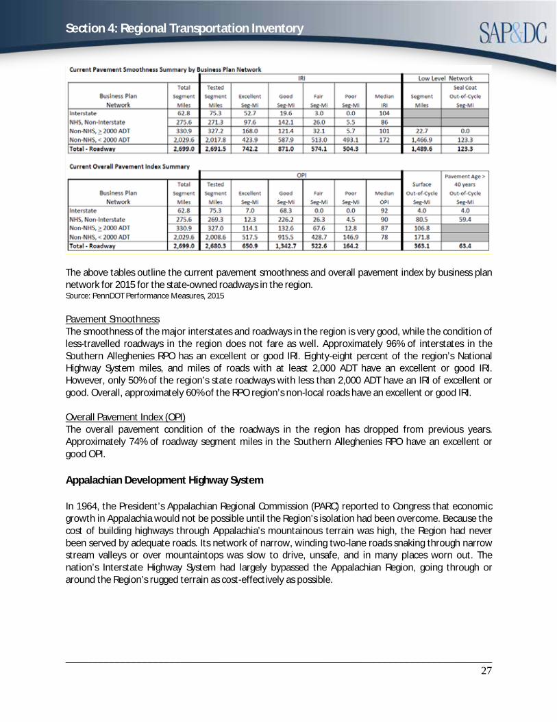
The above tables outline the current pavement smoothness and overall pavement index by business plan network for 2015 for the state-owned roadways in the region. Source: PennDOT Performance Measures, 2015
Pavement Smoothness The smoothness of the major interstates and roadways in the region is very good, while the condition of less-travelled roadways in the region does not fare as well. Approximately 96% of interstates in the Southern Alleghenies RPO has an excellent or good IRI. Eighty-eight percent of the region’s National Highway System miles, and miles of roads with at least 2,000 ADT have an excellent or good IRI. However, only 50% of the region’s state roadways with less than 2,000 ADT have an IRI of excellent or good. Overall, approximately 60% of the RPO region’s non-local roads have an excellent or good IRI.
Overall Pavement Index (OPI) The overall pavement condition of the roadways in the region has dropped from previous years. Approximately 74% of roadway segment miles in the Southern Alleghenies RPO have an excellent or good OPI.
Appalachian Development Highway System
In 1964, the President’s Appalachian Regional Commission (PARC) reported to Congress that economic growth in Appalachia would not be possible until the Region’s isolation had been overcome. Because the cost of building highways through Appalachia’s mountainous terrain was high, the Region had never been served by adequate roads. Its network of narrow, winding two-lane roads snaking through narrow stream valleys or over mountaintops was slow to drive, unsafe, and in many places worn out. The nation’s Interstate Highway System had largely bypassed the Appalachian Region, going through or around the Region’s rugged terrain as cost-effectively as possible.

Section 4: Regional Transportation Inventory
______________________________________________________________________________28
The PARC report and the Appalachian governors placed top priority on a modern highway system as the key to economic development. As a result, Congress authorized the construction of the Appalachian Development Highway System (ADHS) in the Appalachian Development Act of 1965. The ADHS was designed to generate economic development in previously isolated areas, supplement the interstate system, connect Appalachia to the interstate system, and provide access to areas within the Region as well as to markets in the rest of the nation.
The ADHS is currently authorized at 3,090 miles. By the end of FY 2015, 2,784 miles—approximately 88 % of the miles authorized—were complete or under construction. Many of the remaining miles will be among the most expensive to build. The most current estimate (2012) puts the cost to complete the ADHS at $11.4 billion. The federal share of that amount is $6.5 billion. Completion of the ADHS remains a top priority for ARC and SAP&DC.
Status of the ADHS Corridors located in the Southern Alleghenies RPO Region:
Corridor M (U.S. 22, State Route 66) In Pennsylvania, Corridor M runs from I-76 near New Stanton to a junction with I-81 near Harrisburg. The total length of the corridor in Pennsylvania is 200.1 miles. In the Southern Alleghenies RPO, Corridor M crosses east to west through Huntingdon County along U.S. 22, and is among the few remaining miles of uncompleted portions of the ADHS in Pennsylvania. This corridor remains an important missing link to the ADHS in the Southern Alleghenies Region. As of September 30, 2011, the cost to complete Corridor M in Pennsylvania was over $1.4 billion. There is currently no projects underway for Corridor M.
Corridor N (U.S. 219) In Pennsylvania, Corridor N runs from the Maryland state line near Salisbury north to a junction with Corridor M (U.S. 22) near Ebensburg. The total length of the corridor is 65.6 miles. In the Southern Alleghenies Region, Corridor N runs north-south through Somerset County along U.S. 219 from the Maryland State line to Johnstown at the Cambria County border. Construction of the corridor has been completed south through Somerset, PA. As of September 30, 2011, the cost to complete Corridor N in Pennsylvania was $510.1 million. The Planning and Environmental Linkage (PEL) study on a 7-mile section from I-68 in Maryland to Meyersdale was completed in July of 2016. According to the study, two of the fifteen alignments reviewed are being considered for future project analysis. The study recommends Pennsylvania is cooperating with Maryland on this effort. Construction is nearly complete and paving is underway on an 11.4 mile section from Meyersdale north to just south of the Pennsylvania turnpike. Source: PennDOT: US 219, I-68 (MD) to Meyersdale (PA) PEL Study, 2016
Section 4: Regional Transportation Inventory
______________________________________________________________________________29
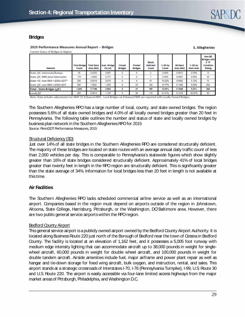
Bridges
The Southern Alleghenies RPO has a large number of local, county, and state owned bridges. The region possesses 5.6% of all state owned bridges and 4.0% of all locally owned bridges greater than 20 feet in Pennsylvania. The following table outlines the number and status of state and locally owned bridges by business plan network in the Southern Alleghenies RPO for 2015 Source: PennDOT Performance Measures, 2015
Structural Deficiency (SD) Just over 14% of all state bridges in the Southern Alleghenies RPO are considered structurally deficient. The majority of these bridges are located on state routes with an average annual daily traffic count of less than 2,000 vehicles per day. This is comparable to Pennsylvania’s statewide figures which show slightly greater than 16% of state bridges considered structurally deficient. Approximately 41% of local bridges greater than twenty feet in length in the RPO region are structurally deficient. This is significantly greater than the state average of 34%. Information for local bridges less than 20 feet in length is not available at this time.
Air Facilities
The Southern Alleghenies RPO lacks scheduled commercial airline service as well as an international airport. Companies based in the region must depend on airports outside of the region in Johnstown, Altoona, State College, Harrisburg, Pittsburgh, or the Washington, DC/Baltimore area. However, there are two public general service airports within the RPO region.
Bedford County Airport This general service airport is a publicly owned airport owned by the Bedford County Airport Authority. It is located along Business Route 220 just north of the Borough of Bedford near the town of Cessna in Bedford County. The facility is located at an elevation of 1,162 feet, and it possesses a 5,005 foot runway with medium edge intensity lighting that can accommodate aircraft up to 38,000 pounds in weight for single-wheel aircraft, 60,000 pounds in weight for double wheel aircraft, and 100,000 pounds in weight for double tandem aircraft. Airside amenities include fuel, major airframe and power plant repair as well as hangar and tie-down storage for fixed wing aircraft, bulk oxygen, and instruction, rental, and sales. This airport stands at a strategic crossroads of Interstates I-70, I-76 (Pennsylvania Turnpike), I-99, U.S. Route 30 and U.S. Route 220. The airport is easily accessible via four-lane limited access highways from the major market areas of Pittsburgh, Philadelphia, and Washington D.C.
Section 4: Regional Transportation Inventory
______________________________________________________________________________30
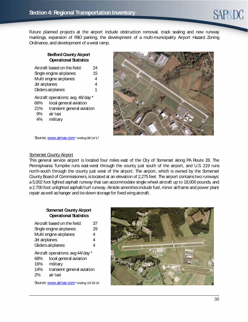
Future planned projects at the airport include obstruction removal, crack sealing and new runway markings, expansion of FBO parking, the development of a multi-municipality Airport Hazard Zoning Ordinance, and development of a west ramp.
Bedford County Airport Operational Statistics
Aircraft based on the field: 24 Single engine airplanes: 15 Multi engine airplanes: 4 Jet airplanes: 4 Gliders airplanes: 1
Aircraft operations: avg. 46/day * 66% local general aviation 21% transient general aviation 9% air taxi 4% military
Source: www.airnav.com *ending 08/14/17
Somerset County Airport This general service airport is located four miles east of the City of Somerset along PA Route 28. The Pennsylvania Turnpike runs east-west through the county just south of the airport, and U.S. 219 runs north-south through the county just west of the airport. The airport, which is owned by the Somerset County Board of Commissioners, is located at an elevation of 2,275 feet. The airport contains two runways: a 5,002 foot lighted asphalt runway that can accommodate single wheel aircraft up to 18,000 pounds, and a 2,700 foot unlighted asphalt/turf runway. Airside amenities include fuel, minor airframe and power plant repair as well as hanger and tie-down storage for fixed wing aircraft.
Somerset County Airport Operational Statistics
Aircraft based on the field: 37 Single engine airplanes: 29 Multi engine airplanes: 4 Jet airplanes: 4 Gliders airplanes: 4
Aircraft operations: avg 44/day * 68% local general aviation 16% military 14% transient general aviation 2% air taxi
Source: www.airnav.com *ending 10/25/16
Section 4: Regional Transportation Inventory
______________________________________________________________________________31
Rail Facilities
The Southern Alleghenies RPO rail facilities consist of both passenger and freight modes. Amtrak service to the region is very limited, with one eastbound and one westbound train each day that stops in Huntingdon. Amtrak service is also available outside of the RPO region in Altoona, Johnstown, Connellsville, and Cumberland, MD. The following is a summary of the region’s rail network.
Passenger Rail In the northern portion of the region, passenger rail service is available in Huntingdon County through Amtrak’s Pennsylvania service. The Pennsylvanian connects New York City and Pittsburgh and is the only passenger service between Harrisburg and Pittsburgh. The Pennsylvanian operates once daily in each direction. An Amtrak station with a waiting room is located in Huntingdon Borough. The station is open 30 minutes prior to arrival time. In 2016 the station had 6,039 boarding’s and alighting’s. Other Pennsylvanian passenger rail stations that also service the region’s residents are located in Altoona, Tyrone, Johnstown, and Lewistown. The limited passenger rail service availability makes the region’s intercity passenger access difficult.
In the southern portion of the region, Amtrak’s Capitol Limited service traverses through Bedford and Somerset Counties along CSX Transportation’s Baltimore-to-Chicago mainline. The Capitol Limited operates one train daily in each direction, but does not stop in the region. The closest stations are located in Cumberland, MD and Connellsville, PA. The Baltimore and Ohio Railroad used to operate a passenger line along the route with a stop in Rockwood, PA, but that service ended in 1971. The former passenger station still stands, but has not been maintained. Somerset County has been in discussions with Amtrak about the possibility of providing a passenger rail stop in Rockwood. Rockwood provides access to the Great Allegheny Passage, a 135 mile rail trail connecting Pittsburgh, PA and Cumberland, MD, and is located within 10 miles of Seven Springs Ski Resort and Hidden Valley Four Seasons Resort. Multiple feasibility studies have made since 2009. It is estimated that annual passenger demand for a Rockwood station is over 2,500 passengers annually.
Keystone Corridor West The Keystone Corridor West is an intercity passenger rail corridor that connects Pittsburgh and Harrisburg, passing through Huntingdon County. The Keystone West line is owned by Norfolk Southern. Amtrak operates one train per day on the line in each direction. The majority of the line is double track, with three tracks over the mountainous portion west of Altoona. Because there is extensive rail freight traffic along this corridor, scheduling additional passenger rail service is difficult because of the need to make frequent crossovers. The Keystone Corridor West makes up the larger Keystone Corridor, which has been designated as one of eleven high-speed rail corridors in the nation. There was a feasibility study completed in August 2014 discussing corridor improvements ranging from 1.5 to 38.3 billion dollars.
Rail Freight
Central/Main Line Corridor The Central Corridor, which traverses across Pennsylvania from Midland to Reading, then on to Philadelphia and Easton, is the largest rail freight corridor in Pennsylvania. The corridor, owned by Norfolk Southern, passes through Huntingdon County. Freight traffic that travels on the corridor makes up 34% of Pennsylvania’s carloads and 54% of ton miles, with much of the traffic being intermodal. Over 50% of the
Section 4: Regional Transportation Inventory
______________________________________________________________________________32
traffic on this corridor is intermodal. As of 2011, 20 percent of the carloads is comprised of coal. Amtrak also operates along this corridor.
Southwest Corridor The Southwest Corridor, which is owned by CSX Transportation, extends from the southwest portion of Bedford County northwest through Somerset County, into Pittsburgh and to the Ohio border. It makes up part of CSX Transportation’s Baltimore-to-Chicago main line. Freight traffic that travels on the corridor makes up 13% of Pennsylvania’s carloads and 17% of ton miles. The corridor’s traffic is diverse, with over half of its commodities being intermodal or coal. As of 2011 coal, steel, waste, and scrap materials make up the majority of the commodities carried on this corridor. Amtrak and The Wheeling & Lake Erie Railway Company also operate along this corridor.
Central/Main Line Corridor Improvements The Pittsburgh Double Stack Clearances project eliminating overhead obstructions will increase intermodal speed and tonnage amount on the entire Central Corridor/Main Line by two to three hours. The Port Perry Bridge Rehabilitation/Replacement I rebuild of the Port Perry Bridge will improve the overall travel times on the Central/Main Line Corridor. The Load Out project in Westmorland County will improve freight movement for the entire corridor.
Southwest Corridor Improvements PBS Coals Inc. Track Rehabilitation project will rehabilitate approximately ten miles of track on the Cambria Branch. The National Gateway project will increase over tonnage by allowing double-stack trains between Chambersburg and Portsmouth. The Pittsburgh Terminal project will allow an initial annual capacity of 50,000 loads.
Other Rail Lines There are numerous feeder lines in the following counties, Bedford, Huntingdon, and Somerset. Most lines are owned by CSXT. Five lines are tourist lines that operate in multiple capacities. The remainder are either branch lines or on the main lines in the area. The additional lines in the Southern Alleghenies total 189 miles of track.
Coal As off 2013 Somerset County had the second highest tonnage of inbound and outbound rail shipments of coal in Pennsylvania, with a total of 8.5 million tons or 12% of the total rail shipments of coal. Overall, Somerset County ranked seventh out of the top rail freight generating counties by unit count in Pennsylvania in 2013, with coal being the primary commodity.
Goods Movement
The movement of goods into, out of, and through the Southern Alleghenies plays a critical role in the economy and infrastructure of the region. The most common mode of freight transport in the region is by truck, with rail being the second most common mode. The highest tonnage of truck freight in the region is transported on the Pennsylvania Turnpike, I-70, and US 30. These routes also experience the highest daily volume of long haul truck traffic in the region. Recurring congestion in the region occurs along the Pennsylvania Turnpike. The Freight Analysis Framework, Version 3.1 2010 projects the daily volume of long haul truck traffic along the Pennsylvania Turnpike and US Route 30 to increase significantly through 2040. This increase is anticipated to magnify congestion along the Pennsylvania Turnpike.
Section 4: Regional Transportation Inventory
______________________________________________________________________________33
Transit
Effective May 1, 2007, the Federal Transit Administration issued final guidance regarding locally developed coordinated public transit-human services transportation plans (“local coordinated plans”) for Federal Fiscal Year (FFY) 2008 and beyond. Federal law (SAFETEA-LU) requires that projects selected for funding under the Elderly Individuals and Individuals with Disabilities (Section 5310), Job Access and Reverse Commute (JARC), and New Freedom programs are derived from a local coordinated plan.
In 2012, the Moving Ahead for Progress in the 21st Century (MAP-21) Act retained the requirement for a Coordinated Plan and consolidated several transportation programs identified under SAFETEA-LU. As a result of funding consolidation, the JARC program was eliminated and the New Freedoms program was consolidated, leaving the Section 5310 Enhanced Mobility of Seniors and Individuals with Disabilities Program as the only FTA funding program dedicated to groups identified through the Coordinated Plan. These changes essentially eliminated the requirement for Coordinated Plans to include low-income individuals in the planning process. Despite these requirements, SAP&DC recognizes the critical nature of serving low-income individuals through human services transportation, and made the conscious decision to continue to include this group in the coordinated planning process.
In December 2015, President Obama signed into law the Fixing America’s Surface Transportation Act, or “FAST Act”. The FAST Act largely continued the existing Section 5310 program unchanged, and carried forward the requirement for locally developed coordinated plans.
The Southern Alleghenies Coordinated Transit – Human Services Plan addresses these new Federal guidelines. The plan includes five major components.
· An assessment of available services that identifies current transportation providers (public,private, and non-profit);
· An assessment of transportation needs for individuals with disabilities, older adults, and peoplewith low incomes;
· Strategies, activities, and/or projects to address the identified gaps between current services andneeds, as well as opportunities to achieve efficiencies in service delivery; and
· An implementation matrix to guide the implementation of strategies for coordinatedtransportation that is dynamic to allow for easy updates in the case of changing technology and views on transportation.
· Ongoing quarterly meetings with a steering committee committed to finding solutions for theregion’s transportation gaps.
Available Services Public transit facilities within the region respond to the public’s need for transportation to jobs, shopping and social opportunities. Public bus service is available in Altoona and Johnstown in the adjoining MPOs, but there are large areas of the RPO that are not served by any form of public transportation. For some residents that do not own a personal vehicle, lack of public transportation is an obstacle to entering the labor force. The following summarizes the public transit facilities in the region along with any other types of transit opportunities that exist.
Section 4: Regional Transportation Inventory
______________________________________________________________________________34
Bedford Rural transit service is provided by the Huntingdon-Bedford-Fulton Area Agency on Aging and Center for Community Action. Both services are provided to Huntingdon, Bedford and Fulton Counties with secondary service to medical facilities throughout Pennsylvania and parts of Maryland and West Virginia. The service operates Monday through Friday 4:00 am to 7:00 pm with no holiday service. Reservations for the service must be made 24 hours in advance for access and the service is based on a demand response system. The majority of ridership is persons 60 years of age and older.
Fulton Rural transit service is provided by the Huntingdon-Bedford-Fulton Area Agency on Aging. The service is provided to Huntingdon, Bedford and Fulton Counties with secondary service to medical facilities throughout Pennsylvania and parts of Maryland and West Virginia. The service operates Monday through Friday 4:00 am to 7:00 pm with no holiday service. Reservations for the service must be made 24 hours in advance for access and the service is based on a demand response system. The majority of ridership is persons 60 years of age and older. Additionally, the Fulton County Partnership offers a Medical Assistance Transportation Program and an Employment Transportation Assistance Program, both operating on a demand response system.
Huntingdon Rural transit service is provided by the Huntingdon-Bedford-Fulton Area Agency on Aging and a partnership with the Pennsylvania CareerLink. The service is provided to Huntingdon, Bedford and Fulton Counties with secondary service to medical facilities throughout Pennsylvania and parts of Maryland and West Virginia. The service operates Monday through Friday 4:00 am to 7:00 pm with no holiday service. Reservations for the service must be made 24 hours in advance for access and the service is based on a demand response system. The majority of ridership is persons 60 years of age and older. The Center for Community Action, through a partnership with Huntingdon County, offers free transportation for ambulatory veterans going to the Huntingdon County VA clinic. Juniata College offers free transportation services to enrolled college students.
Somerset Rural transit service is provided by the Somerset County Transportation System (SCTS) and the Medical Assistance Transportation Program (MATP). The SCTS provides services in local communities as well as trips from outlying areas in Somerset and Johnstown. The system provides curb-to-curb service to the general public on a demand-response basis. The MATP is a transportation service funded by the Pennsylvania Department of Public Welfare and provides services to qualified medical facilities for non-emergency medical appointments. Both services operate Monday through Friday 8:00 am to 4:00 pm, no holiday or weekend hours.
The county also possesses three taxi companies and multiple bus services to provide transit service to the Somerset County area. The Debolt-Somerset Bus Company provides three routes originating in Somerset destined for Pittsburgh, Cumberland, MD, and Johnstown. The Schrock Sight Seeing Service provides complete bus charter and tour service throughout the United States. The Cambria County Transit Authority (CAMTRAM) also has fixed routes servicing northern Somerset County.
The following is an inventory of known transportation providers (public, private and non-profit) currently operating in the Southern Alleghenies RPO.
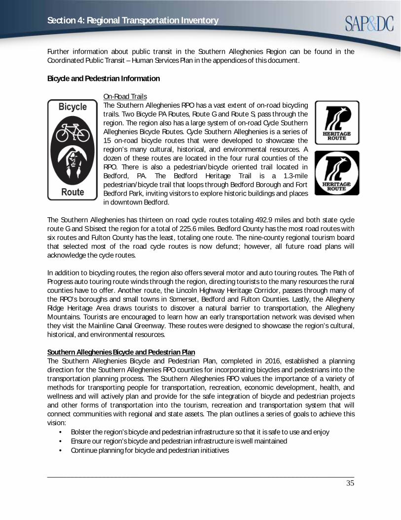
Section 4: Regional Transportation Inventory
______________________________________________________________________________35
Further information about public transit in the Southern Alleghenies Region can be found in the Coordinated Public Transit – Human Services Plan in the appendices of this document.
Bicycle and Pedestrian Information
On-Road Trails The Southern Alleghenies RPO has a vast extent of on-road bicycling trails. Two Bicycle PA Routes, Route G and Route S, pass through the region. The region also has a large system of on-road Cycle Southern Alleghenies Bicycle Routes. Cycle Southern Alleghenies is a series of 15 on-road bicycle routes that were developed to showcase the region’s many cultural, historical, and environmental resources. A dozen of these routes are located in the four rural counties of the RPO. There is also a pedestrian/bicycle oriented trail located in Bedford, PA. The Bedford Heritage Trail is a 1.3-mile pedestrian/bicycle trail that loops through Bedford Borough and Fort Bedford Park, inviting visitors to explore historic buildings and places in downtown Bedford.
The Southern Alleghenies has thirteen on road cycle routes totaling 492.9 miles and both state cycle route G and S bisect the region for a total of 225.6 miles. Bedford County has the most road routes with six routes and Fulton County has the least, totaling one route. The nine-county regional tourism board that selected most of the road cycle routes is now defunct; however, all future road plans will acknowledge the cycle routes.
In addition to bicycling routes, the region also offers several motor and auto touring routes. The Path of Progress auto touring route winds through the region, directing tourists to the many resources the rural counties have to offer. Another route, the Lincoln Highway Heritage Corridor, passes through many of the RPO’s boroughs and small towns in Somerset, Bedford and Fulton Counties. Lastly, the Allegheny Ridge Heritage Area draws tourists to discover a natural barrier to transportation, the Allegheny Mountains. Tourists are encouraged to learn how an early transportation network was devised when they visit the Mainline Canal Greenway. These routes were designed to showcase the region’s cultural, historical, and environmental resources.
Southern Alleghenies Bicycle and Pedestrian Plan The Southern Alleghenies Bicycle and Pedestrian Plan, completed in 2016, established a planning direction for the Southern Alleghenies RPO counties for incorporating bicycles and pedestrians into the transportation planning process. The Southern Alleghenies RPO values the importance of a variety of methods for transporting people for transportation, recreation, economic development, health, and wellness and will actively plan and provide for the safe integration of bicycle and pedestrian projects and other forms of transportation into the tourism, recreation and transportation system that will connect communities with regional and state assets. The plan outlines a series of goals to achieve this vision:
· Bolster the region’s bicycle and pedestrian infrastructure so that it is safe to use and enjoy· Ensure our region’s bicycle and pedestrian infrastructure is well maintained· Continue planning for bicycle and pedestrian initiatives
Section 4: Regional Transportation Inventory
______________________________________________________________________________36
· Educate our region’s stakeholders, elected officials, and public at-large of key regional initiativesinvolving bicycle and pedestrian transportation
· Maximize the benefits of transportation investments in the region
Off-Road Trails The Southern Alleghenies Region, rich in recreational resources, offers a great number of off-road trails. As mentioned above the Southern Alleghenies has ten parks and twenty-nine state game lands with approximately 202 trails totaling 457.09 miles. The most notable state parks for off road trails are Blue Knob State Park, and Trough Creek State Park. Other regional and county trails total 77 with a total mileage of 1,072.1. Regional hiking opportunities are also provided by the Mid-State Trail, Laurel Ridge Trail, Tuscarora Trail, and Standing Stone Trail. Huntingdon County has the most county trails.
Off-road hiking/biking opportunities are also available with several rails-to-trails routes in the region, including the PWS Trails system and the Great Allegheny Passage in Somerset County, as well as the Lower Trail in Huntingdon County. The Pike-to-Bike trail located in Bedford and Fulton Counties is an 8.5 mile hike/bike trail located on an abandoned section of Pennsylvania Turnpike. The Bedford County side of the turnpike trail will be functional in late September 2017.
The region also offers several mountain biking opportunities, including the Allegrippis Trails located along Raystown Lake in Huntingdon County. The Allegrippis Trails is a premier mountain biking trail system containing 32 miles of single track stacked loop trails. The 24 trails in the system were designed and built to provide sustainable trails for a variety of human uses including mountain biking, hiking, trail running, snowshoeing and cross-country skiing. The trails are available for public use year-round.
Please see Appendix L for greater detail in the Bicycle and Pedestrian Plan.
Southern Alleghenies Greenways and Open Space Network Plan Bedford, Blair, Cambria, Fulton, Huntingdon, and Somerset Counties, along with the Southern Alleghenies Planning & Development Commission (SAP&DC), have developed the Southern Alleghenies Greenways and Open Space Network Plan. The Plan outlines a series of policies and projects for linking existing natural and man-made resources within the region’s six counties. By connecting these assets into a comprehensive greenway network, the region’s natural resources are leveraged to promote and strengthen their value to the region for a range of purposes. A more extensive inventory of the region’s recreational trail opportunities can be found in the plan.
Transportation Alternatives PennDOT’s Transportation Alternative Set-Asides offer funding opportunities to help expand transportation choices and enhance the transportation experience through small, community-based transportation and recreation activities related to surface transportation. Transportation Alternatives (TA) activities are federally funded projects that expand travel options by enhancing the transportation infrastructure through cultural, historic, aesthetic and environmental improvements. Alternative projects must be one of 11 eligible activities and must relate to surface transportation.
· Bicycle and Pedestrian Facilities· Bicycle and Pedestrian Education· Conversion of Abandoned Railway Corridors to Trails· Construction of Turnouts, Overlooks, and Viewing Areas· Outdoor Advertising Management
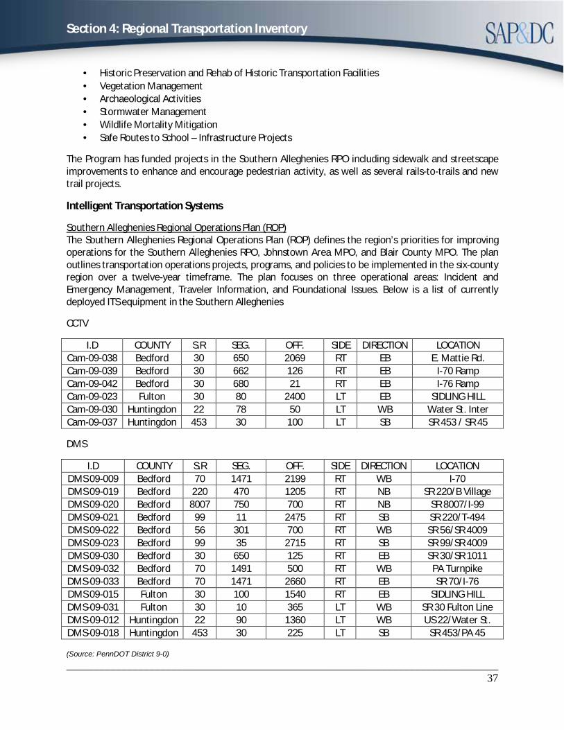
Section 4: Regional Transportation Inventory
______________________________________________________________________________37
· Historic Preservation and Rehab of Historic Transportation Facilities· Vegetation Management· Archaeological Activities· Stormwater Management· Wildlife Mortality Mitigation· Safe Routes to School – Infrastructure Projects
The Program has funded projects in the Southern Alleghenies RPO including sidewalk and streetscape improvements to enhance and encourage pedestrian activity, as well as several rails-to-trails and new trail projects.
Intelligent Transportation Systems
Southern Alleghenies Regional Operations Plan (ROP) The Southern Alleghenies Regional Operations Plan (ROP) defines the region’s priorities for improving operations for the Southern Alleghenies RPO, Johnstown Area MPO, and Blair County MPO. The plan outlines transportation operations projects, programs, and policies to be implemented in the six-county region over a twelve-year timeframe. The plan focuses on three operational areas: Incident and Emergency Management, Traveler Information, and Foundational Issues. Below is a list of currently deployed ITS equipment in the Southern Alleghenies
CCTV
I.D COUNTY S.R SEG. OFF. SIDE DIRECTION LOCATION Cam-09-038 Bedford 30 650 2069 RT EB E. Mattie Rd. Cam-09-039 Bedford 30 662 126 RT EB I-70 Ramp Cam-09-042 Bedford 30 680 21 RT EB I-76 Ramp Cam-09-023 Fulton 30 80 2400 LT EB SIDLING HILL Cam-09-030 Huntingdon 22 78 50 LT WB Water St. Inter Cam-09-037 Huntingdon 453 30 100 LT SB SR 453 / SR 45
DMS
I.D COUNTY S.R SEG. OFF. SIDE DIRECTION LOCATION DMS 09-009 Bedford 70 1471 2199 RT WB I-70 DMS 09-019 Bedford 220 470 1205 RT NB SR 220/B Village DMS 09-020 Bedford 8007 750 700 RT NB SR 8007/I-99 DMS 09-021 Bedford 99 11 2475 RT SB SR 220/T-494 DMS 09-022 Bedford 56 301 700 RT WB SR 56/SR 4009 DMS 09-023 Bedford 99 35 2715 RT SB SR 99/SR 4009 DMS 09-030 Bedford 30 650 125 RT EB SR 30/SR 1011 DMS-09-032 Bedford 70 1491 500 RT WB PA Turnpike DMS-09-033 Bedford 70 1471 2660 RT EB SR 70/I-76 DMS 09-015 Fulton 30 100 1540 RT EB SIDLING HILL DMS-09-031 Fulton 30 10 365 LT WB SR 30 Fulton Line DMS-09-012 Huntingdon 22 90 1360 LT WB US 22/Water St. DMS-09-018 Huntingdon 453 30 225 LT SB SR 453/PA 45
(Source: PennDOT District 9-0)
Section 4: Regional Transportation Inventory
______________________________________________________________________________38
Key recommendations from the plan include:
1) Establish dedicated funding for ITS2) Maximizing the benefits of the TMCs3) Better maintain and manage existing equipment4) Expedite the communication line request process5) Permit the use of wireless communication systems6) Improve guidance on incident management protocols7) Integrate reporting systems
Traffic Signals The Southern Alleghenies Region has a total of 162 traffic signals located at 81 intersections throughout the four rural counties. There are currently two programs available to help fund traffic signal improvements for local government agencies; Automated Red Light Enforcement (ARLE) and Green Light-Go.
Safety
The safety of motorists, cyclists, and pedestrians is a priority to the Southern Alleghenies RPO. The RPO strives to select projects that will improve safety of the regions transportation network. The Southern Alleghenies RPO supports the goals of Pennsylvania’s Strategic Highway Safety Plan.
Pennsylvania’s Strategic Highway Safety Plan (SHSP) The goal of Pennsylvania’s Strategic Highway Safety Plan (SHSP), developed in 2017, is to reduce annual traffic fatalities to 1,130 or less by 2019 through a comprehensive approach to traffic safety. The SHSP was developed to target priority Safety Focus Areas (SFAs) and outline strategies to help reduce highway fatalities on Pennsylvania’s roadways.
Pennsylvania’s SHSP identifies the following “16 key emphasis areas” Safety Focus Areas: 1. Reducing Impaired Driving 9. Enhancing Safety on Local Roads2. Increasing Seat Belt Usage 10. Improving Pedestrian Safety3. Infrastructure Improvements 11. Improving Traffic Records Data4. Reducing Speeding & Aggressive Driving 12. Commercial Vehicle Safety5. Reducing Distracted Driving 13. Improving Emergency/Incident Influence Time6. Mature Driver Safety 14. Improving Bicycle Safety7. Motorcycle Safety 15. Enhancing Safety in Work Zones8. Young & Inexperienced Driver Safety 16. Reducing Vehicle-Train Crashes
Section 4: Regional Transportation Inventory
______________________________________________________________________________39
Crashes
Over the past five years the total number of crashes in the Southern Alleghenies RPO region has decreased and the total number of crash-related fatalities has remained stable but declining, except for 2014. The percent of seat belt usage has stayed above 80% in the last five years, and the total number of pedestrian injuries have stayed below five with a sharp decrease from 2015.
Environmental
Linking Planning and NEPA Linking Planning and NEPA (LPN) is an effort to link the environmental review process to planning and program development. The LPN process will help ensure that issues that may affect the project delivery schedule and budget are considered during the planning and programming process. The LPN process was developed with coordination from PennDOT, Planning Partners, and other stakeholders.
The objectives of the LPN process include: · Integrated collaboration and decision-making· “Up-front” problem analysis and planning· Fiscally sound project selection· Well-defined and consistent scoping process
As part of the LPN process, various project screening forms were developed to help gather more information about projects. The Level 1 project screening form includes basic information about a
Section 4: Regional Transportation Inventory
______________________________________________________________________________40
transportation problem including its location and description, as well as any known land use or environmental concerns associated with the problem or area. The Level 2 project screening form will analyze the problem area and report on potential historical and environmental resources that may be impacted in the project location. This will help to identify potential environmental concerns with a project during the planning and programming stages of project development.
PennDOT Connects The LPN process is currently being phased out and replaced by PennDOT Connects. The Connects program ensures bicycle and pedestrian activities, transit, freight, cultural events, stormwater management, utilities, and green infrastructure are considered early in the planning process. Moreover, this program ensures input from local government agencies and planning partners, to the greatest extent possible, are incorporated into projects.
Marcellus Shale Drilling and development of the oil and natural gas industries in the United States has been a common event from the late 1800s through the present. With recent advances in technology for horizontal drilling and hydraulic fracturing, development and extraction of natural gas from the Marcellus Shale formation is occurring. The largest Marcellus Shale formation in the United States spans areas of West Virginia, Virginia, Ohio, Maryland, Pennsylvania, and New York. In the Southern Alleghenies Region, Cambria and Somerset Counties overlay the Marcellus Shale layer. To lesser degrees, Blair, Bedford, Fulton, and Huntingdon Counties overlay Marcellus Shale. All six counties overlay the Utica Shale layer, a much deeper layer beneath the Marcellus Shale. Active drilling has sharply declined in the last five years. Although Marcellus Shale has declined currently, it is expected to increase in the next decade to also include the drilling of the Utica Shale layer.
With lessons learned from the state's northern tier counties Marcellus Shale development has dramatic impacts in county services, infrastructure, transportation, local economy, employment, housing, education, and land use. Growing Marcellus Shale activity will continue to have a greater impact on the region’s local roads and bridges.
The following is an outline of the reported Marcellus Shale Activity in the Southern Alleghenies RPO Region from 2016:
· Drilled Marcellus Shale Wells: 8 · Marcellus Shale Water Withdrawal Locations: 12· Active Marcellus Shale Well Permits: 0 · Facilities Accepting Marcellus Shale Waste: 0
Wind Energy There are currently 1300 megawatts of wind power generated annually spread out over 27 wind farms supplying enough energy for 350,000 Pennsylvanian residences. The highest wind energy producing counties in the Southern Alleghenies Region are Blair, Cambria, and Somerset. Somerset is the only wind energy producer in the RPO. As of 2015, Somerset County has 206 turbines producing 383.5 daily megawatts. Given the 32% job creating increase in 2016, lowered price per kilowatt, and more efficient and powerful turbines it is assumed that wind energy will increase in the RPO in the future. This will lead to new items such as, new access road construction, traffic mitigation, over size load permits, etc.
Section 4: Regional Transportation Inventory
______________________________________________________________________________41
Coal Pennsylvania is the third highest coal producing state in the United States and the only state producing anthracite. The Southern Alleghenies Region is one of the largest Bituminous coal producers in the country with mines in three RPO counties. The RPO currently has 43 active coal producing sites, 34 sites are surface mines. Although more mines were opened in 2016, there has been a -20.9% change in employment and a -7.5% change in production between 2015 and 2016. The transportation of coal has always been a factor in the RPO when planning future road projects. The following is an outline of the current coal production sites in the RPO from 2016:
· Number of Operators: 22 · Number of Surface Mines 33 · Number of Underground Mines 9 · Number of Coal Refuse Sites 1
Agriculture The agricultural industry has always been a large economic factor in Pennsylvania. Not only is Pennsylvania a top producer in multiple agricultural categories, it is also one of the highest agricultural exporters as well. The same holds true in the RPO. The 2012 agricultural census is showing an average 4.5% increase in total farmland and a 37.3% increase in total market value for the four county RPO. A large agricultural industry can cause road damage, spill responses, and traffic congestion issues, etc. The following is an outline of the reported agricultural activity in the Southern Alleghenies RPO from the most recent agricultural census:
· Number of Farms: 3,839 · Total Amount of Acreage: 694,886 · Top Crop: Haylage · Top Livestock: Meat Type Chickens
Section 4: Regional Transportation Inventory
______________________________________________________________________________42
Page intentionally left blank
Section 5. Vision, Goals, and Objectives
_____________________________________________________________________________________43
Vision
Provide a safe, efficient, and sustainable multi-modal transportation system that fosters economic and community development and meets the needs of the region through innovation.
Goal 1: Develop a reliable and resilient transportation network, which links the region with the nation’s markets and provides regional access for industrial, commercial, educational, and recreational growth areas to support tourism and the economic vitality of the region.
Objectives: · Identify regional growth and investment areas.· Continue the decision-making process to include considerations for industrial, commercial,
education, and recreational benefits and impacts.· Continue to support operations and planned expansion improvements at the local multimodal
transportation facilities in the region.· Encourage partnerships between planning and tourism focused organizations.· Promote preservation of cultural resources and ensure a sense of place for residents and those
visiting the region.
Goal 2: Foster a strong commitment to maintenance of the existing transportation system and stormwater facilities.
Objectives: · Identify a Regional Core Transportation Network to more strategically direct transportation
investments in the interest of the overall system. · Develop regional asset management goals and performance measures.
Goal 3: Increase the safety of the transportation system for motorized and non-motorized users.
Objectives: · Identify high crash locations and implement improvements to help reduce serious injury crashes
and fatalities. · Include safety goals and criteria in the region’s performance measures and decision-making
process. · Encourage the incorporation of sidewalks, bike lanes, and wider shoulders where appropriate
into planned transportation improvements. · Provide training and assistance to local governments regarding potential access management
techniques.
Goal 4: Improve quality of life and equity of access through enhanced community access via public transportation, including passenger rail, bus, transit, and human services transportation.
Objectives: · Implement Coordinated Transit-Human Service Plan and bolster regional connectivity.· Encourage the coordination of local transit or human services efforts to streamline the process
of requesting transportation assistance.
Section 5. Vision, Goals, and Objectives
_____________________________________________________________________________________44
· Work with transit and human services providers to identify areas with high or increasingconcentrations of low income, elderly, or disabled populations that are underserved by publictransportation.
· Support expanded passenger rail service between Pittsburgh and Harrisburg by promotingadditional Amtrak train routes.
Goal 5: Maximize the benefits of transportation investments in the region.
Objectives: · Develop project prioritization criteria that helps to ensure that transportation funds are being
invested wisely. · Identify innovative funding sources and opportunities to leverage transportation investments.· Improve the project delivery process to help expedite project development and reduce costs by
working with the Department of Transportation.· Provide training and technical assistance to local municipalities through the Local Technical
Assistance Program (LTAP) to help ensure that liquid fuels funds are being used efficiently.· Support statewide initiatives related to transportation funding and modernization strategies,
including recommendations identified in the Governor’s Transportation Funding AdvisoryCommission’s Report.
· Assist municipalities with the incorporation of access management techniques by adoption ofstand-alone ordinances or revisions to sub-division and land development ordinance (SALDO.)
· Promote benefits of municipal maintenance agreements to ensure the maximum investment inlocal projects.
Goal 6: Ensure the safety, efficiency, and usability of the freight system for effective movement of goods.
Objectives: · Work with the freight industry to identify shipping and freight needs as well as critical rural and
urban freight corridors. · Leverage potential funding sources for safety improvements at grade crossings.· Work with companies that ship goods via rail freight to identify shipping and freight needs as
well as areas where mobility improvements are needed.· Assist companies in finding and applying for federal and state funding for rail freight
improvements including construction and rehabilitation.
Goal 7: Inform and educate the public, stakeholders, and elected officials on key regional transportation initiatives.
Objectives: · Review and update the Southern Alleghenies RPO Public Participation Plan and Environmental
Justice procedures on a regular basis to ensure that the public has the opportunity to serve an active role in the transportation planning process.
· Promote social media and electronic communication regarding transportation news andinitiatives that are pertinent to the Southern Alleghenies Region.
Section 5. Vision, Goals, and Objectives
_____________________________________________________________________________________45
· Attend local municipal elected official’s conventions and PennDOT’s annual meetings, includingPennDOT Connects meetings, to discuss the transportation planning and project solicitationprocess.
Goal 8: Plan for bicycle and pedestrian initiatives.
Objectives: · Implement the recommended Action Plan from the Southern Alleghenies Bicycle and Pedestrian
Plan. · Implement recommendations from the Southern Alleghenies Greenways and Open Space
Network Plan. · Coordinate with the Pennsylvania’s Department of Conservation and Natural Resources,
Department of Community and Economic Development, and Department of Transportation on bicycle and pedestrian projects in the region.
· Encourage communities to apply for Transportation Alternatives Set-Asides, CommunityDevelopment Block Grants, Act 13 Funds, Multimodal Transportation Funds and Mini-Grants for streetscape improvements in community centers.
Section 5. Vision, Goals, and Objectives
_____________________________________________________________________________________46
Page intentionally left blank
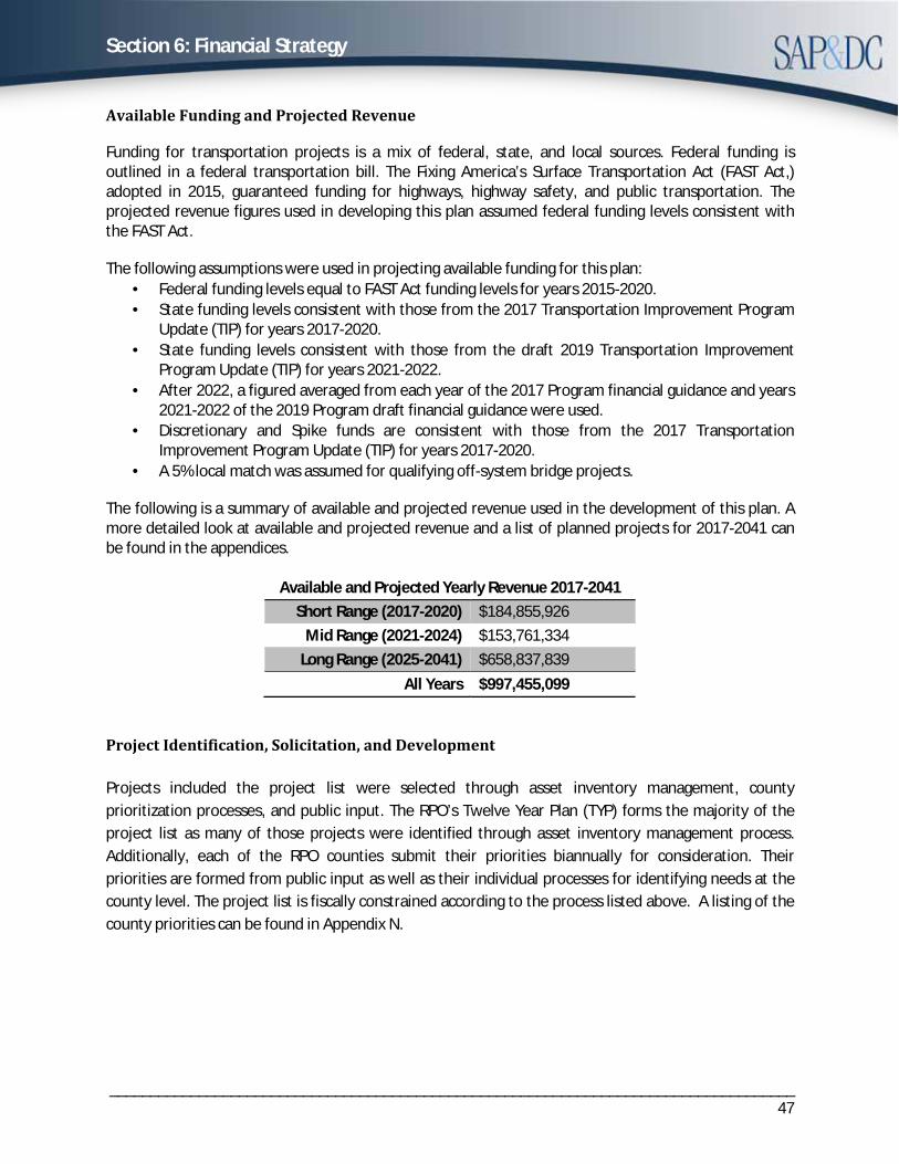
Section 6: Financial Strategy
_____________________________________________________________________________________47
Available Funding and Projected Revenue
Funding for transportation projects is a mix of federal, state, and local sources. Federal funding is outlined in a federal transportation bill. The Fixing America’s Surface Transportation Act (FAST Act,) adopted in 2015, guaranteed funding for highways, highway safety, and public transportation. The projected revenue figures used in developing this plan assumed federal funding levels consistent with the FAST Act.
The following assumptions were used in projecting available funding for this plan: · Federal funding levels equal to FAST Act funding levels for years 2015-2020.· State funding levels consistent with those from the 2017 Transportation Improvement Program
Update (TIP) for years 2017-2020.· State funding levels consistent with those from the draft 2019 Transportation Improvement
Program Update (TIP) for years 2021-2022.· After 2022, a figured averaged from each year of the 2017 Program financial guidance and years
2021-2022 of the 2019 Program draft financial guidance were used.· Discretionary and Spike funds are consistent with those from the 2017 Transportation
Improvement Program Update (TIP) for years 2017-2020.· A 5% local match was assumed for qualifying off-system bridge projects.
The following is a summary of available and projected revenue used in the development of this plan. A more detailed look at available and projected revenue and a list of planned projects for 2017-2041 can be found in the appendices.
Available and Projected Yearly Revenue 2017-2041 Short Range (2017-2020) $184,855,926
Mid Range (2021-2024) $153,761,334 Long Range (2025-2041) $658,837,839
All Years $997,455,099
Project Identification, Solicitation, and Development
Projects included the project list were selected through asset inventory management, county prioritization processes, and public input. The RPO’s Twelve Year Plan (TYP) forms the majority of the project list as many of those projects were identified through asset inventory management process. Additionally, each of the RPO counties submit their priorities biannually for consideration. Their priorities are formed from public input as well as their individual processes for identifying needs at the county level. The project list is fiscally constrained according to the process listed above. A listing of the county priorities can be found in Appendix N.

Section 6: Financial Strategy
_____________________________________________________________________________________48
Unfunded Needs
Based on current financial projections, there are greater needs than there is available funding to fill them. An illustrative list was devised to highlight viable projects that fall outside of current funding constraints. In the event additional funding becomes available, these projects are to be considered for programming. The illustrative list was devised from county submissions of significant projects that have gone through the respective county’s vetting process. These regionally significant projects, which fall outside of the financial constraints of this plan, can be found in Appendix H.
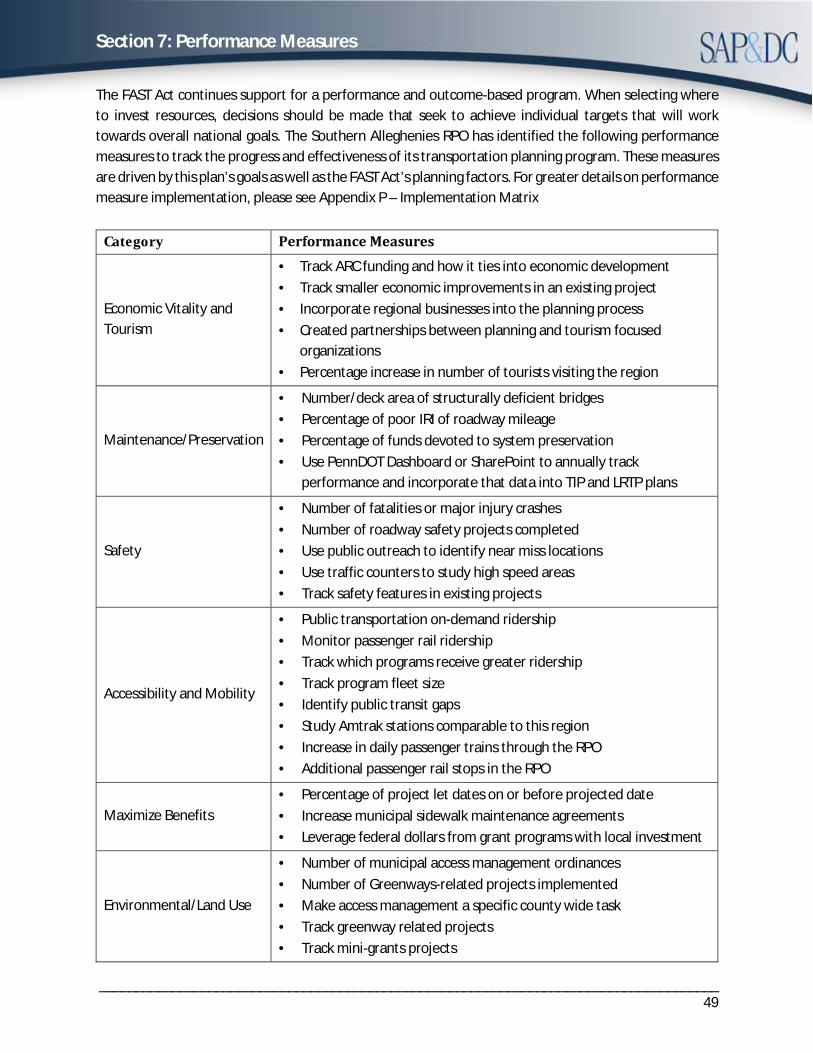
Section 7: Performance Measures
_____________________________________________________________________________________49
The FAST Act continues support for a performance and outcome-based program. When selecting where to invest resources, decisions should be made that seek to achieve individual targets that will work towards overall national goals. The Southern Alleghenies RPO has identified the following performance measures to track the progress and effectiveness of its transportation planning program. These measures are driven by this plan’s goals as well as the FAST Act’s planning factors. For greater details on performance measure implementation, please see Appendix P – Implementation Matrix
Category Performance Measures
Economic Vitality and Tourism
· Track ARC funding and how it ties into economic development· Track smaller economic improvements in an existing project· Incorporate regional businesses into the planning process· Created partnerships between planning and tourism focused
organizations· Percentage increase in number of tourists visiting the region
Maintenance/Preservation
· Number/deck area of structurally deficient bridges· Percentage of poor IRI of roadway mileage· Percentage of funds devoted to system preservation· Use PennDOT Dashboard or SharePoint to annually track
performance and incorporate that data into TIP and LRTP plans
Safety
· Number of fatalities or major injury crashes· Number of roadway safety projects completed· Use public outreach to identify near miss locations· Use traffic counters to study high speed areas· Track safety features in existing projects
Accessibility and Mobility
· Public transportation on-demand ridership· Monitor passenger rail ridership· Track which programs receive greater ridership· Track program fleet size· Identify public transit gaps· Study Amtrak stations comparable to this region· Increase in daily passenger trains through the RPO· Additional passenger rail stops in the RPO
Maximize Benefits · Percentage of project let dates on or before projected date· Increase municipal sidewalk maintenance agreements· Leverage federal dollars from grant programs with local investment
Environmental/Land Use
· Number of municipal access management ordinances· Number of Greenways-related projects implemented· Make access management a specific county wide task· Track greenway related projects· Track mini-grants projects
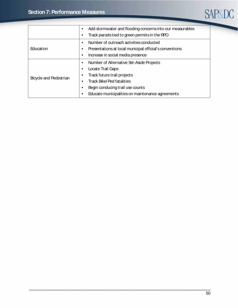
Section 7: Performance Measures
_____________________________________________________________________________________50
· Add stormwater and flooding concerns into our measurables· Track parcels tied to green permits in the RPO
Education · Number of outreach activities conducted· Presentations at local municipal official’s conventions· Increase in social media presence
Bicycle and Pedestrian
· Number of Alternative Set-Aside Projects· Locate Trail Gaps· Track future trail projects· Track Bike/Ped fatalities· Begin conducing trail use counts· Educate municipalities on maintenance agreements
Section 8. Plan Modification and Updates
_____________________________________________________________________________________51
The Southern Alleghenies RPO Long Range Transportation Plan (LRTP) is required to be formally updated every five years. All major formal updates will be required to undergo a 30-day public comment period and follow all public involvement procedures as outlined in the Public Participation Plan.
Minor updates may be made periodically to the plan as needed. These will be recommended by the Rural Transportation Technical Committee (RTTC) and approved by the Rural Transportation Coordinating Committee (RTCC). Minor updates shall be approved at public meetings, but do not need to undergo the 30-day public comment period requirements.

Section 8. Plan Modification and Updates
_____________________________________________________________________________________52
Page intentionally left blank