Embed Size (px)
Citation preview

Athens Journal of History XY
1
Spatial Reflections of Social Change:
The Change of Urban Pattern in the Ottoman Era
By Fulya Üstün Demirkaya
Cities established thousands of years ago reach our day as products of continuous
development in the historical process. While cities are reshaped under new
governments every time in the vicious cycle of establishment, expansion,
destruction and reestablishment, this process is accompanied by changes in
physical appearance. In this sense, there is a rich context in terms of social and
structural-spatial change in the establishment of an Ottoman urban texture with its
genuine characteristics, meeting of a city with the Ottoman factor, and the qualities
of the changes in the previously owned heritage. Undeniably, the gaining of this
shape by the Ottoman city that is described as genuine, was affected by the
Byzantium and Seljuk urban culture as well as the Arabic-Islamic urban culture.
Ottoman cities were formed and organized over this historical background. This
study aims to explain which changes/transformations took place in the Anatolian
cities with more than three millennia of settlement tradition due to practices known
as “the Ottoman tradition” by presenting the spatial structure of the Anatolian-
Ottoman city and elements forming the urban texture. Thus, it is important to
reveal the acquired heritage first. The reshaping of cities that were shaped based
on Byzantium and/or Seljuk cultures in the light of political, economic,
demographic and other social changes with the Ottoman conquest, especially
continuities, are discussed in the context of transformation. However, considering
the long time period when the empire was in power and its broad area of land that
is distributed in three continents; the study covers the process that started in the
era of conquest where cities met Ottoman elements for the first time, and reaching
the Tanzimat reformation that represents something other than the traditional
Ottoman city concept, where new reforms were applied.
"As this wave from memories flows in,
the city soaks it up like a sponge and expands.
The city, however, does not tell its past,
but contains it like the lines of a hand,
written in the corners of the streets,
the gratings of the windows,
the banisters of the steps…
every segment marked in turn with
scratches, indentations, scrolls."1
Cities founded thousands of years ago that still exist in the present day
are a result of their continuous development throughout history. In this
manner, cities are not only institutive, economic or political objects, but are
Assistant Professor, Karadeniz Technical University, Turkey.
1. I. Calvino, Invisible Cities, trans. W. Weaver (Orlando: Harcourt Brace, 1974), 10-
11.
Vol. X, No. Y Demirkaya: Spatial Reflections of Social Change…
2
also architectural phenomena2 throughout the historical development
process.
The real characterization of a physical space can only be obtained over
time. City spaces, which undergo changes and transformations, have been
restructured throughout history by wars and migrations. As cities recycle
between the processes of founding, expanding, destruction, and re-founding
in the hands of new occupants, this process included physical changes each
time.
After the emergence of cities and noticeability of settlement
segmentation, the structuring of cities is determined by the shape of external
relations of cities and the qualities of their social structure.3 Life started
within the city by and within the walls, which were considered safe as cities
were founded, expanded beyond the walls over time, and mostly expanded
to areas where the trading took place. Following this long transformation
process of city structures, physical structures and institutional models were
modeled after a combination of forts, villages, and bazaars.
This physical changes occurring in the city during the founding process
is connected with social events and relationships. Each society is in a
process of change in every moment, and each factor that triggers social
changes plays an important role in each of the processes; they affect each
other and can redirect the transformation of the city. In this continuity in
which each aspect articulated the others, images that made it impossible to
separate one city from another in terms of the definition of an ideal city
were developed. A city that could be identified with a single description can
be defined through these new images. In short, a colorful environment
occurs in cities with the addition of each person by the changing beliefs of
each era and society, culture, and religion. As stated by Braudel,4 cities are
actually engines that are constantly in motion. However, the issue that
should be emphasized here is that, although change takes place in a short
time period, its effects on the physical structure or the form of the city stay
much longer.5
There is a delay in social change and the successive change in the urban
form in terms of changes in structure.6
Sometimes, the new function may
also be met in the existing physical structure or change in urban form may
take place much later than the functional change. This is a continuous
process. A city’s physical structure or urban form in a section of time is a
2. N. Özaslan, Konstantinopol’da Bir Osmanlı Kentinin Kuruluşu: Eyüp, [Birth of
an Ottoman town in Constantinople: Eyüp], Osmanlı Mimarlığının 7 Yüzyılı "Uluslarüstü
Bir Miras" (Istanbul: Yapı Endüstri Merkezi Publications, 1999), 238-243.
3. I. Tekeli, Anadolu'da Yerleşme Sistemi ve Yerleşme Tarihleri [Anatolian Settlement
System and Settlement Dates] (Istanbul: TVYY, 2011), 36.
4. F. Braudel, Uygarlıkların Grameri [Grammar of Civilizations], trans. M. A.
Kılıçbay (Istanbul: Imge Publications, 2006).
5. S. Aktüre, 19. Yüzyıl Sonunda Anadolu Kenti Mekansal Yapı Çözümlemesi
[Analysis of Spatial Structures at the End of the 19th-century Anatolian Cities] (Ankara:
ODTÜ Mimarlık Fakültesi Basım İşliği, 1981).
6. K. Dziewonski, "Typological Problems in Urban Geography," Geographia
Polonica, 2(1964): 139-144.
Athens Journal of History XY
3
result of functional differentiations that take place in a broad time period
and in different incidences. Due to this characteristic, it is inevitable to
discuss a wide-spectrum analysis of urban form in terms of the relationships
of urban functions-spatial structure-urban form.7
While a settlement’s history might go back thousands of years,
Anatolia, which changed rulers many times, has a city culture that is a
symbolical reflection of each occupant’s institutional system. In this
manner, changes in the physical texture developed due to political, social,
economic, and cultural dynamics, The Ottoman empire represents a
different era of physical changes in terms of those obtained in heritage and
the evolution of this unique heritage.
In this manner, the studied subject can be defined as research into how
applications that are named "Ottoman Traditions" played a role in the spatial
changes of Anatolian Cities. The Tanzimat Era in the frame of the
westernization/modernization idea joined to the Ottoman politics where new
reforms were applied and has great differences from the "traditional" was
excluded from the study. The shaping of the “Anatolian-Ottoman” city
following the meeting of Anatolia with the Ottomans and the changes that
take place as a natural process connected to this, are discussed in terms of
especially continuities and transformation by establishing a relationship
between social structure and causality.
The method used in the study to present the spatial structure of the
Anatolian-Ottoman city is as following: as the Ottoman city has been
shaped and organized8 over the Seljuk -Byzantium and Arab-Islam urban
cultures, it is first needed to describe how Anatolian cities were shaped
under the Byzantium and Seljuk rules and what the elements of the urban
texture are. As for almost any period, the most important resource in
determining the physical structure of cities is the presence of periodic
structures. Therefore, first of all, a literature review was conducted to
review the studies on Byzantine and Seljuk urban history and urban life, and
the general framework defined by the elements of urban texture, the
positions of these elements, and their interrelations was monitored visually
by diagrams. With the same method, the functional areas of the Ottoman
city were determined, and the position of these areas that are joined onto the
pre-Ottoman urban texture and their effects on the change/development in
the physical texture were investigated. The general framework established
regarding the Ottoman urban texture was also demonstrated visually.
City Concept: Acquired Heritage
Different dimensions such as institutional, demographical, socio-
economic, social and cultural are present in a city’s concept. Cities with
only institutional and demographic dimensions can be settlements that reach
7. Aktüre, 19. Yüzyıl Sonunda Anadolu Kenti Mekansal Yapı Çözümlemesi, 1981).
8. T. Baykara, "Osmanlı Devleti Şehirli Bir Devlet Midir?" ["Is the Ottoman State a
Urban State?"], Osmanlı, vol. V (Ankara:Yeni Türkiye Publication, 1999), 528-535.
Vol. X, No. Y Demirkaya: Spatial Reflections of Social Change…
4
a certain population; however, this is not the proper scale for the conception
of a city. 9
In this manner, founding a city, which was described by Plato10
as "the
greatest merit of mankind" is a process. City foundation is the behavior
integrity that is formed by the settlement of cultural accumulation and the
behavior regarding historical heritage, changing purposes and altered needs
over time and the integrity of the parts when pieced together.11
In short,
people and societies determine the form of cities based on their beliefs,
cultures and religions.12
This format might show deviation in different
cultures for different reasons (religious-ethnical structure, administrative-
political terms, geographical-climate terms, demographical development).
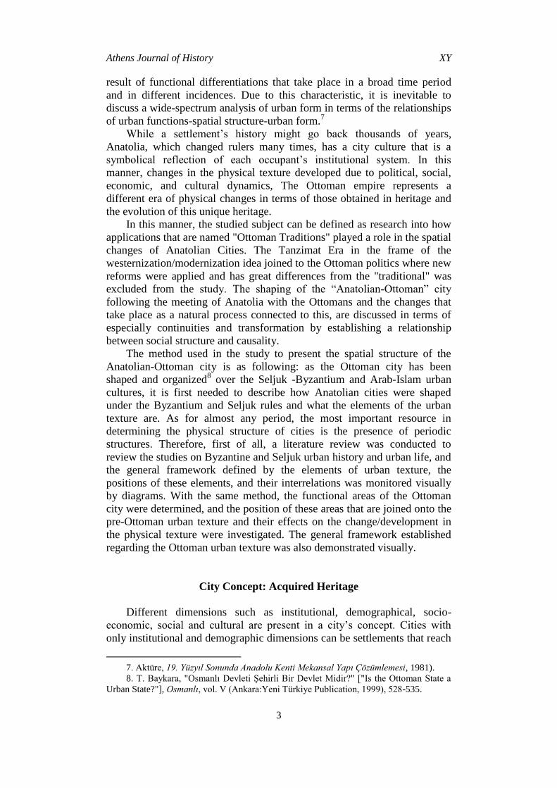
The Ottoman city is one of the best examples of this integrity that
defines multiple dynamics; while representing the basis of the Byzantine
and Seljuk city culture, Arab-Islam cities that were influenced by the
conquest of Aleppo, Damascus, Baghdad, and Cairo, are an important factor
in this formation (Figure 1). The Byzantine city, which form the first stage
of these factors that can be identified as inherited factors, has a developed
market economy, an organized13
economic life with the development of
modest houses, churches, monasteries and small shops under the protection
of military outposts while having governors as bishops.14
9. Considering that there are interactions of multiple reasons for emergence of cities;
Lampard questions the origin of cities in a framework of interrelations determined by
variables of population accumulation, technological capacity, organization and
environment. According to Lampard, the determining factor in this framework is transition
from collecting food to producing food. According to Sjoberg, three conditions are needed
for emergence of cities. These are suitable ecological infrastructure, technology, social
organization and a developed structure of hegemony. Childe, by mentioning differences of
cities, explains the differences in reasons that paved the way to cities and the forms of
emergence of cities as the geographical structures, demographic structures and cultures of
societies. R. Aslanoğlu, Kent, Kimlik, Küreselleşme [Urban, Identity, Globalization]
(Bursa: Asa Publications, 1998), 23.
10. Platon; Devlet [The Republic] (İstanbul: Remzi Publication, 1992)
11. T. Cansever, İslamda Şehir ve Mimari [City and Architecture in Islam] (Istanbul:
Timaş Publications, 2012), 115.
12. T. Cansever, Osmanlı Şehri [Ottoman City] (Istanbul: Timaş Publications, 2012), 17.
13. Aktüre, 19. Yüzyıl Sonunda Anadolu Kenti Mekansal Yapı Çözümlemesi, 1981, 7.
14. K. Rheidt, City or Village? Housing and Settlement in Middle and Late Byzantine
Anatolia, Tarihten Günümüze Anadolu’da Konut ve Mimarlık [Housing and Settlement in
Anatolia A Historical Perspective] (Istanbul: TVY, 1996), 221-233.
Athens Journal of History XY
5
Figure 1. Urban Pattern of Aleppo and Damascus Source: City map of Aleppo taken from; H. Z. Watenpaugh, The image of an Ottoman city:
Imperial architecture and urban experience in Aleppo in the 16th and 17th centuries
(Boston: BRILL, 2004.) City map of Damascus taken from; J. L. Porter, Five years in
Damascus: Including an account of the history, topography, and antiquities of that city;
with travels and researches in Palmyra, Lebanon, and the Hauran (London: John Murray,
1855).
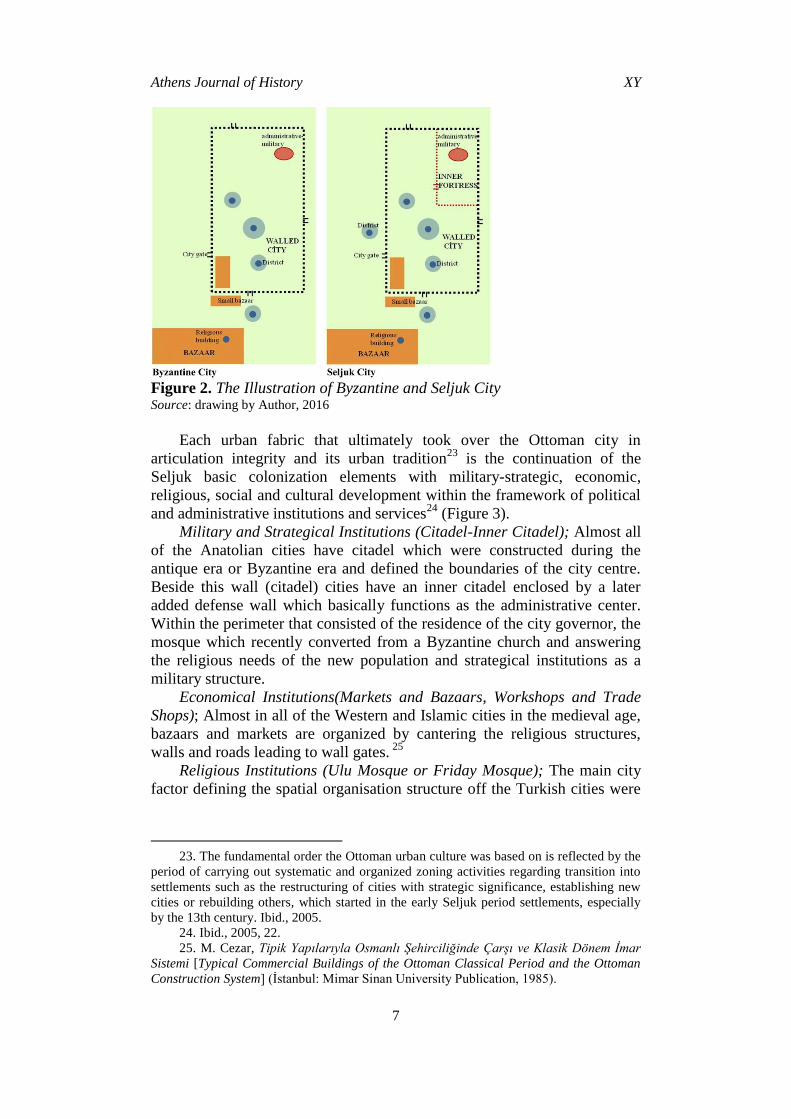
Byzantine city (Figure 2), which was founded with the factors of
religious elements and defense elements as its spatial core,15
was formed
into the districts formed by religious, occupational, and social elements, and
has a fortress that was the military-administrative center and economical
centers such as bazaars, which defined the city’s spatial setup.16
There are no adequate archeological studies on the pre-Turkish and
post-Turkish urban forms of Medieval Anatolia except a few on structures
that have reached our day in some cities. The most general analysis that may
be made on the physical texture of the Seljuk era Anatolian cities may be
that the palaces were made in citadels that we know from Iran and Central
Asia, and there was an internal city (Şehristan) containing a Friday Mosque,
a Government Office or a Palace, and an external city containing the
markets and towns. 17
However, the city in the Seljuk Anatolia is not one
that Turks established, but one that they discovered. Therefore, as long as
there are no natural disasters, it was out of the question that a city with a
15. Considering cities one by one, it may be concluded that Turks acquired two kinds
of cities. While there was no clear-cut separation at the time Turks arrived in Anatolia,
researchers divided Byzantine cities into two models. One of these is the "multiple-part"
city consisting of small, separated residential areas located on the settlement of an ancient
city, and the other is the "castle city" with most of the residential areas are located inside
fortress walls. U. Tanyeli, "Anadolu-Türk Kentinde Fiziksel Yapının Evrim Süreci (11-15.
yy)" ["The Evolutionary Process of the Physical Structure in Anatolian Turkish Cities
(11th-15th c.)"] (Ph.D. Thesis in Architecture, İstanbul Teknik University, 1987).
16. K. Özcan, "Erken Dönem Anadolu-Türk Kenti Anadolu Selçuklu Kenti ve
Mekânsal Öğeleri" ["Early Anatolian-Turkish Town Anatolian Seljuk Town and its Spatial
Elements"], Bilig [Journal of Social Sciences of the Turkic World] 55(2010): 193-220.
17. O. Turan, "Selçuklu Devri Vakfiyeleri: 1. Şemsettin Altun-aba Vakfiyesi ve
Hayatı" ["Seljuk Era Foundation"], Belleten, vol. XI, (1947), 197-235.
Vol. X, No. Y Demirkaya: Spatial Reflections of Social Change…
6
castle and fortress would be destroyed after acquisition and another would
be constructed.18
The Seljuk administrative system, which was the first Turkish political
unity following the Byzantine occupation, provided the Turkish city with an
identity composed of a Christian-Byzantine cultural infrastructure by
reforming it on the foundation of Middle Asia Turkish and Iran Turkish
Islam nomadic or semi-nomadic lifestyle traditions (Figure 2). Seljuks
followed a systematic settlement policy for reactivating the international
transit trade routes that were deactivated during times of conquest and
opened the settlements that were ruined during the dark ages known as the
era of conquest and resettlement wars, and fastened the Turk-Islamic
colonization of the Anatolian geography that they had taken from under the
Byzantine rule.19
After the conquest of Anatolia, the first practice that took place in cities
taken from Byzantium was converting a church into a mosque as a symbol
of conquest.20
New residents of the city also got organized around this
structure and settled.21
The third part that constitutes the spatial organizing
order of the Seljuk city is the market or the bazaar area. In this spatial
organization order, social and cultural service organizations are composed
of Islamic madrasa-mosque complex composition in function, external walls
have been a secondary focus that direct the development of urban
development.22
18. D. Kuban, Selçuklu Çağında Anadolu Sanatı [The Art of the Seljuk Period in
Anatolia] (İstanbul: Yapı Kredi Publications, 2008), 66-67.
19. For detailed information Ö. L. Barkan, "Osmanlı İmparatorluğu’nda Bir İskân ve
Kolonizasyon Metodu Olarak Vakıflar ve Temlikler I" ["Foundaditons and Dispositions as
a Method of Colonization in the Ottoman Empire"], Vakıflar Dergisi I(1942): 279-386; Ö.
L. Barkan, "Osmanlı İmparatorluğunda Kolonizatör Türk Dervişleri ve Zaviyeler"
["Colonizer Turkish Dervishs and Zawiyas in the Ottoman Empire"], Vakıflar Dergisi, vol.
II (1942), 255-353.
20. C. Cahen, Osmanlılardan Önce Anadolu [Anatolia before Ottoman Era], trans. E.
Üyepazarcı (İstanbul: TVYY, 2000), 208.
21. For detailed information on the effects of this practice that may be accepted as a
significant conquest tradition in the Seljuk period on the structure of neighborhoods
constituting the physical texture of the era; A. Akşit, "Selçuklular Devrinde Kent İskânı ve
Mahalleler" ["City Settlement and Districts during Seljuk Empire"], Çankırı Karatekin
Üniversitesi Sosyal Bilimler Enstitüsü Dergisi 5, no. 1(2014): 67-88.
22. K. Özcan, Anadolu'da Selçuklu Dönemi Yerleşme Sistemi ve Kent Model(ler)İ
[Urban Network and Urban Model(s) in Anatolia During the Seljuk Period] (PhD diss.,
Selçuk University, Konya, 2005)
Athens Journal of History XY
7
Figure 2. The Illustration of Byzantine and Seljuk City Source: drawing by Author, 2016
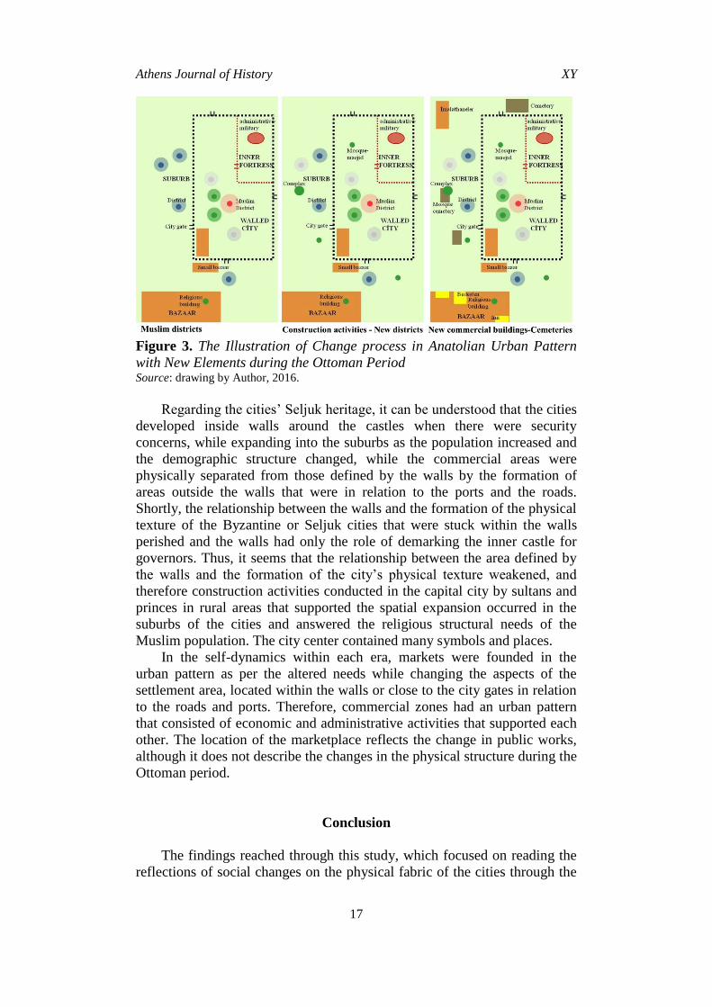
Each urban fabric that ultimately took over the Ottoman city in
articulation integrity and its urban tradition23
is the continuation of the
Seljuk basic colonization elements with military-strategic, economic,
religious, social and cultural development within the framework of political
and administrative institutions and services24
(Figure 3).
Military and Strategical Institutions (Citadel-Inner Citadel); Almost all
of the Anatolian cities have citadel which were constructed during the
antique era or Byzantine era and defined the boundaries of the city centre.
Beside this wall (citadel) cities have an inner citadel enclosed by a later
added defense wall which basically functions as the administrative center.
Within the perimeter that consisted of the residence of the city governor, the
mosque which recently converted from a Byzantine church and answering
the religious needs of the new population and strategical institutions as a
military structure.
Economical Institutions(Markets and Bazaars, Workshops and Trade
Shops); Almost in all of the Western and Islamic cities in the medieval age,
bazaars and markets are organized by cantering the religious structures,
walls and roads leading to wall gates. 25
Religious Institutions (Ulu Mosque or Friday Mosque); The main city
factor defining the spatial organisation structure off the Turkish cities were
23. The fundamental order the Ottoman urban culture was based on is reflected by the
period of carrying out systematic and organized zoning activities regarding transition into
settlements such as the restructuring of cities with strategic significance, establishing new
cities or rebuilding others, which started in the early Seljuk period settlements, especially
by the 13th century. Ibid., 2005.
24. Ibid., 2005, 22.
25. M. Cezar, Tipik Yapılarıyla Osmanlı Şehirciliğinde Çarşı ve Klasik Dönem İmar
Sistemi [Typical Commercial Buildings of the Ottoman Classical Period and the Ottoman
Construction System] (İstanbul: Mimar Sinan University Publication, 1985).

Vol. X, No. Y Demirkaya: Spatial Reflections of Social Change…
8
the mosques which were named Cami-i Kebir (mosque), Sultan Mosque or
Great Mosque.26
Socio-Cultural Institutions (Islamic Social Complexes); Seljuks
constructed service institutions in order to improve the social and cultural
city life, provide for the medical services and educational services of the
Anatolian cities which were obtained from Byzantine rule. Construction
activities mostly conducted by the Sultans, taken the role of developing the
city parts outside wall as well as answering to the needs of the populace
living within the city walls.
Political-Administrative Institutions (Sultan Palace and Summer-Winter
Palace and Manors); Palaces are positioned in the inner castle as the spatial
reflection of the state power and authority while the other palaces which
were named as summer palaces or palaces outside the city walls were
constructed on the near proximity of the cities.27
Ottoman City: Change in Urban Pattern/Change Process
As the extended geography of the Ottoman Empire considered, it is
undoubted that the new politics conducted by the new administrative system
will result in different changes as the special cultural environment of the
cities considered. However, the topic mentioned within this notice will be
the applications which were applied to every corner of the empire and
adopted as a policy by the Ottomans. As the reflections to the Ottoman
Capital and the rural areas differ in terms of scale, they are similar in
foundation.
The answer to the question of which factors form the Ottoman City is
more complicated than the ones which were formed under the rule of other
rulers.28
On the long time period that the empire prevailed, on the extended
areas expanded to three continents, each Ottoman city developed a format
related with their unique dynamics and tradition understandings. If we want
to settle the cities in a general frame regardless of the original geographies
of the cities, we encounter the time factor. For this reason a typical Ottoman
city definition can only be possible by considering the different era topics
which have different characteristics and different elements (economical,
administrative, technological etc.) in the long time period that the empire
ruled.
26. T. Baykara, "Ulucami -Selçuklu şehrinde iskânı belirleyen bir kaynak olarak-"
["Great Mosque-as a source describing the settlement in the city of -Seljuk"] Belleten LX,
no. 227(1996): 34-59.
27. S. Redford, "Thirteenth–Century Rum Seljuk Palaces and Palace Imagery," Ars
Orientalis 23(1993): 215-232.
28. For detailed reviews of studies conducted on Anatolian-Ottoman cities; M. Öz,
"Osmanlı Klasik Döneminde Anadolu Kentleri" ["Anatolian Cities in the Ottoman Classical
Age"], TALID 3, no. 6(2005): 57-88. A comprehensive bibliography has been prepared and
published by the History Foundation on urban research in Turkey, including historical
research. See Kent Araştırmaları Bibliyografyası [Urban Studies Bibliography] (İstanbul:
Tarih Vakfı Yurt Publications, 2001).
Athens Journal of History XY
9
The era consisting of the foundation of the empire to the Conquest of
Istanbul, defined as the settling period of the Ottoman Culture.29
This
process carries the specialities of the obtained heritage in terms of the
cultural texture as well as seen in the institution and management strategies.
Period following this period, especially in the 15th and 16th centuries,
though cities carry the traces of the Byzantine, Islam and Seljuk heritages,
succeeded to add their unique characteristics to this mix and the Ottoman
Empire's unique forms joined the urban pattern. In combination with the
acquired heritage, the mosques, imarets, government buildings built by the
Ottomans and the markets/bazaars which were the center of economic
activities, the Ottoman urban texture came to be, as denoted in the Ottoman
fiscal register as "cum'a kılınur ve bazarı durur".30
Rules of the typical Ottoman urban pattern which were described by
Cerasi31
as wooden houses with broken roofs, a domed mosque, a special
order of the city roads, a market the and separation of the economical and
residential roles and expansion of the city composition to nature are also the
basic factors forming the city structure. The relation of these factors in the
Anatolian cities during the Ottoman Empire era with the city parts founded
before the Ottoman era, the continuation or demolition of this relation and
the tracing of the typological or functional positioning of this relation
constitute the main purpose of this study.
City Boundaries
Ottoman cities were established over the city structure of already
present structures, administrative, military, and religious public structures
were redesigned to answer to the Ottoman society and management needs,
and city centers and nearby areas were opened to new residents.
Demographically, according to the change in the identity of the city
population by force (conquest-population policies) or automatically
increasing the city’s population (increasing the number of people or
occurrence of different ethnic/religious groups) can be shown in the change
in the city’s boundaries and the addition of new sections to the city spaces
that are not parallel.32
Ottoman cities were physically comprised of three sections: the
inherited inner fort, a secondary fort that was constituted after the city’s
expansion that covers the actual city and houses the population and market-
29. M. Akdağ, Türkiye'nin İktisadi ve İçtimai Tarihi 2 [Economical and Social History
of Turkey-2] (İstanbul: Cem Publication, 1995).
30. The cities with the Friday mosque and the bazaar were called the city.
31.M. M. Cerasi, Osmanlı Kenti Osmanlı İmparatorluğu'nda 18. ve 19. Yüzyıllarda
Kent Uygarlığı ve Mimarisi [Ottoman City Urban Civilization and Architecture in 18th and
19th Centuries in the Ottoman Empire], trans. Asli Ataöv (İstanbul: Yapı Kredi
Publications, 1999), 24.
32. For policies followed in the process of making a city suitable for the Ottoman
society and governing needs after an Ottoman conquest; H. İnalcık, "Ottoman Methods of
Conquest," Studia Islamic II (1954): 103–129.
Vol. X, No. Y Demirkaya: Spatial Reflections of Social Change…
10
bazaar, and lastly the suburbs that developed outside the city walls as a
result of the demographic change that occurred within the city. The
development of the cities evolved around religious, economic, and
residential structures for these three-segmented formations.33
However, the decline of the walls partially or completely as a result of
the disappearance of safety concerns is undoubtedly why the Ottoman Cities
were much more developed compared to the almost-prison cities observed
in the Byzantine and Seljuk eras.
In this manner, there are two upper topics that can call the Ottoman
City structure “settlement modules"34
that directly communicate with the
area unrelated to the city walls or related to the city walls via the wall gates.
These are the imarets, which are districts where people of the same ethnicity
and religion reside together and conduct religious duties together.
Economic and social buildings were articulated on the market, bazaar,
and religious structural core, which formed the focal point and center of
attractions, and included districts that were organized around religious
structures with regard to the texture, and the boundaries of the cities were
eventually defined.35
Factors of the Urban Patterns: Quarters
The purpose of worshiping and serving the gods around the world was
the main reason for the foundation of the cities, and this provided the
development of the "quarter units" that had evolved around religious
structures since the antique era (Figure 3).
In the Ottoman era, cities were built of individual quarters.36
Ottoman
quarters were the smallest administrative units that were capable of
managing themselves. Thus, the expansion of Ottoman cities was possible
thanks to the creation of new quarters. While quarters that were described as
"miniature sections" of the Ottoman social life by Bayramoğlu Alada37
had
unorganized and complicated physical structures, they were in fact
consistent and formatted in terms of the society’s needs.38
33. Ö. Ergenç, "Osmanlı Şehrinde Esnâf Örgütlerinin Fizik Yapıya Etkileri" [The
Effects of the Tradesman Associations on the Physical Structure in Ottoman City], I.
Uluslararası Türkiye’nin Sosyal ve Ekonomik Tarihi Kongresi Tebliğleri (1978), 103-109.
34. M. M. Cerasi, Osmanlı Kenti Osmanlı İmparatorluğu'nda 18. ve 19. Yüzyıllarda
Kent Uygarlığı ve Mimarisi, 1999, 70.
35. N. Üstündağ, "Osmanlı'da "Şehir" ve Şehri Geliştiren Unsurlardan Biri Olarak
Ayanlar: Vidin ve Rusçuk Örnegi (18.Yüzyıl)" ["The "Ayans" in the Otornan Empire as an
Element in the Development of Urbanization and Cities: The Vidin and Rusçuk Example
(Eighteenth Century)"], Türkiyat Araştırmaları Dergisi 2(2005): 149-167.
36. K. Alver, "Mahalle: Mekân ve Hayatın Esrarlı Birlikteliği" ["The Neigborhood:
The Mysterious Union of Space and Life"] İdeal Kent 2(2010): 116-139.
37. A. Bayramoğlu Alada, Osmanlı-Türk Şehrinde Mahalle 9Ph.D. diss., Ankara:
Ankara University, 1989).
38. N. Üstündağ, "Osmanlı'da "Şehir" ve Şehri Geliştiren Unsurlardan Biri Olarak
Ayanlar: Vidin ve Rusçuk Örnegi (18.Yüzyıl)" ["The "Ayans" in the Otornan Empire as an
Element in the Development of Urbanization and Cities: The Vidin and Rusçuk Example

Athens Journal of History XY
11
Cities are developed each day in parallel with their demography, and
thus started to expand with the development new quarters related with the
new formations conducted by the foundations with increasing population
and construction activities (Figure 3). In accordance with the Ottoman city
practice that was conducted using their traditional approach following
conquest, which is a triggering dynamic of change, suburb formation
processes started with the re-allocation of non-Muslims to outside the walls
as part of the quarters’ foundation or re-foundation processes. A new
population and palace were settled inside the walls with official state
bureaucrats. The suburbs were settled by people who came afterwards, and
they formed a group called "cemaat." These groups developed over time and
formed quarters.39
The social center in the quarters of the Ottoman city is the mosque.40
Required religious buildings were built within the cities on the basis of
ethnic and religious groups’41
requirements, and churches of the remaining
or less-observed religions were created if there were non-Muslim districts;
this situation was different in the Islamic districts. If the mentioned district
occurred through demographic changes in the Christian districts, the needs
of worship would be fulfilled through the conversion of already present
(Eighteenth Century)"], Türkiyat Araştırmaları Dergisi no. 2(2005): 149-167. S. Çabuk and
K. Demir, Osmanlı Kentlerinde Mahallelerin Mekânsallaştırılabilmesi İçin Bir Yöntem
Denemesi: Kayseri Örneği [A Methodological Attempt to Evaluate the Spatialization of
Quarters in Ottoman Cities: the Case of Kayseri], Karabük Üniversitesi Tarih Kültür ve
Sanat Araştırmaları Dergisi [Journal of History Culture and Art Research] 1, no. 3(2012),
135-153.
39. It is possible to follow the settlement policy after conquest in Trabzon which was
conquered in a late period compared to other cities in Anatolia. In the city which was
conquered by Fatih the Conqueror in 1461, local people were separated into three groups
according to the census which was first done 25 years after the conquest in conformity with
new organization Fatih the Conqueror founded. The first group was taken Ottoman Sultans
and other servitor pashas’ service, the second group was removed from the city to make
them settle in other places. The third group was removed from the walled city and was
settled to its surroundings. Turkish-Muslim families who came from other cities settled in
the walled city. According to this, the Muslim population was recorded in census as
1cemaat (community) and 1 mahalle (district) in 1486. The only district that belonged to
Muslims was the district named "Azebân-ı mî-şeved" which was created with people who
came to the city voluntarily. For 15-16. century quarters see, H. W. Lowry, The
Islamization & Turkification of the City of Trabzon (1461-1583) (İstanbul: The ISIS Press,
2009); H. Bostan, XV.-XVI. Asırlarda Trabzon Sancağında Sosyal ve İktisadi Hayat [Social
and economic life in Trabzon Sancaq in XV-XVI. Century] (Ankara: Publications of the
Turkish Historical Society, 2002). For wider evaluation about topic see F. Üstün
Demirkaya, Toplumsal Dinamikler Bağlamında Trabzon Kent Dokusunun Dönüşümü
(Komnenos Hanedanlığı'ndan Cumhuriyet'e Kadar) [Transformation of Urban Fabric in
Trabzon in the Contex of Social Dynamics (From Komnenos Dynasty to Republic)] (Ph.D
diss., Trabzon: Karadeniz Technical University, 2014).
40. Ö. Ergenç, "Osmanlı Şehrindeki Mahallenin İşlev ve Nitelikleri Üzerine" ["On the
Functions and Qualities of the Quarters in the Ottoman City"], Osmanlı Araştırmaları IV
(1984): 69-78.
41. Considering that space was divided into pieces in terms of social classes in
structuring of Egyptian, Greek and Roman cities, the history of dividing cities into social
and physical sub-units may be taken back to the first emergence of the phenomenon of the
cities.
Vol. X, No. Y Demirkaya: Spatial Reflections of Social Change…
12
churches and chapels to mosques, and this was carried out in newly settled
places or a district formed by the newcomers through the construction of
new religious structures.
Factors of the Urban Pattern:
Foundation Complexes-Construction Activities 42
The definition of Mumford43
"Each generation writes its biography in
the buildings it creates" summarizes the roles implied by the city to its
residents with its physical structures.
Since the earliest period of the spread of Islamic faith, worship space
requirements in conquered areas has generally been met by building
mosques, and according to the type of conquest, temples located in seized
areas were partially or completely converted into mosques, which provided
an example for the later eras to follow. In the tradition of the Ottoman
conquest, the conversion of a city's largest places of worship into mosques
can be considered as the continuation or reflection of their application in
those years.44
In summary, cities represent a process of physical change that
is formed by the Ottoman "conquest tradition," but that also includes more
because of their current statuses. Maybe the tradition of this new culture,
which can be considered the most tangible indicator as per construction
activities, found meaning in the cities (Figure 3).
The change in this power makes it obvious that the cities enter a process
of change that can be described as relative "reconstruction" by describing
the new administrative order. Changes in the administrative system might
show themselves in architectural formation, construction techniques in
methodology, in materials, and even in huge city arrangements in addition
to other very limited ways. The Ottoman sultans, especially during the
classical era, expressed themselves through the construction of monumental
complexes.45
42. The item list that belongs to the public for an Ottoman city is long: charities,:
imaret (the kitchens for the poor), hospital, mental hospitals, teaching constructions:
madrasa, primary school, library trade constructions: covered bazaar, inn, caravansary,
ottoman bazaar, market, coffee house, management constructions: Palace, mansion,
religious constructions: mosque, shrine, lodge and non-Muslims worship constructions, big
factories: mint, armoury, shipyard, hygiene constructions: bath, public fountain, fountain,
water tank M. M. Cerasi, Osmanlı Kenti Osmanlı İmparatorluğu'nda 18. ve 19. Yüzyıllarda
Kent Uygarlığı ve Mimarisi 1999.
43. L. Mumford, Tarih Boyunca Kent Kökenleri, Geçirdiği Dönüşümler ve Geleceği
[The City in History: Its Origins, Its Transformations, and Its Prospects] (İstanbul: Ayrıntı
Publications, 2007).
44. For wider evaluation about the topic see; Ö. İ. Tuluk, Osmanlı Kent Kimliğinin
Mistik Öğeleri: Dini Yapılar ve Mezarlıklar [Mystical Elements of Ottoman city İdentity:
Religious Buildings and Cemeteries] Hece: Medeniyet, Edebiyat ve Kültür Bağlamında
Şehirlerin Dili no.13, (2009): 150-152.
45. C. Can, "Tanzimat ve Mimarlık" ["Tanzimat and Architecture"], in Osmanlı
Mimarlığının 7 Yüzyılı "Uluslarüstü Bir Miras" (İstanbul: YEM Puplications, 1999), 130-136.

Athens Journal of History XY
13
In the city’s heritage from the Seljuks, the mosque continued its role as
the focal point of the Ottoman cityscape if the settlement was a city. In cities
conquered from the Byzantines, in the process that started with the
conquest, the first construction activity was the conversion of the largest
church in the city to a mosque, which would represent the new
administrative system and signify the city’s conquest by building a mihrab
and minbar and making it possible to have Friday Prayer and complete its
conversion into a mosque. The Ottomans developed a structural and
population system to answer social needs, just like the Seljuks.
The urban pattern developed within the new Muslim districts formed in
new cities or conquered cities by the construction of mosques or masjids by
either foundations or notable persons. However, as a part of the Ottoman
population tradition, the presence and sustainability of the structures was
important for understanding social and cultural lives. Thus, while mosques
and the Muslim society seemed to be in the foreground in Ottoman cities,
many non-Muslim elements helped sustain their lives for centuries.46
The adoption of the present texture of a city was briefly attempted
during the Ottoman era while developing a visual language and a spatial
organization that reflected the presence of the new rulers.
Elements of the Urban Pattern; Bazaar-Commercial Areas
In a typical Ottoman city, the religious and commercial center is a
fundamental characteristic. While the religious center develops around the
ulu mosque, which can be observed in almost all cities from the early
period, Turkish settlements included new structures that were usually
covered bazaars and inns, and formed the development focus of the
commercial center.47
Ottoman bazaars show interesting characteristics due to their urban
locations. In the Ottoman urban culture, the strict separation of economic
activities and residential areas made the development of a social and
economic center necessary. The close proximity of the bazaar to the fort or
to the city walls resulted both in them becoming connection points for trade
flows and its location and the presence of the roads that allowed the
residents to reach the bazaars were the factors that defined the bazaars’
urban locations.48
46. N. Üstündağ, "Osmanlı'da "Şehir" ve Şehri Geliştiren Unsurlardan Biri Olarak
Ayanlar: Vidin ve Rusçuk Örnegi (18.Yüzyıl)", 2005, 149-167.
47. M. M. Cerasi, Osmanlı Kenti Osmanlı İmparatorluğu'nda 18. ve 19. Yüzyıllarda
Kent Uygarlığı ve Mimarisi, 1999, 121.
48. M. S. Şahinalp and V. Günal, Osmanlı Şehircilik Kültüründe Çarşı Sisteminin
Lokasyon ve Çarşı İçi Kademelenme Yönünden Mekânsal Analizi [Spatial Analysis of
Bazaar Systems: Their Location and Forms in the Ottoman Urbanism Culture], Millî
Folklor 24, no.93(2012): 149-168.
Vol. X, No. Y Demirkaya: Spatial Reflections of Social Change…
14
The formation of a bazaar49
as the geometrical center of the city
expanding around it, can demonstrate that social reinforcement structures
formed the required infrastructure tools that helped trade settle down on a
solid foundation for the first circle around the covered bazaar and mosque.
The structures for the accommodation and clean-up needs of incoming
merchants are located within this belt. In this manner, covered bazaars,
guest houses, cisterns, ranges, and warehouse structures that were
constructed as a requirement of an active economic life both helped the
city’s economic development and played important roles in the city’s
physical, architectural, and cultural development.
The second circle of the city "bazaar" is formed by the bazaars of some
of the professionals who enable production variety. This ring is generally
formed by the workshops that can cause unrest around them, and workshops
particularly require water. Bazaars such as tanneries and paint shops that
require significant amounts of water during production cycles were
established around areas where water was readily available and shops such
as tanneries, paint shops, blacksmiths, carpenters, and boiler smiths that can
cause bad smells, images, and noise pollution were established in the outer
ring.50
(Figure 3)
Elements of the Urban Pattern: Open Spaces and Cemeteries
Old Turkish cities expressed their identity through their mosques,
masjids, madrasas, fountains, hamams, manors, houses, and the cemeteries
that surrounded them.51
Ottoman cities did not have green in their streets,
while each house had trees in the gardens, seemed green from a distance due
to the plantation of a tree which is especially a cypress tree on to each
deceased person.
In Islamic cities, cemeteries are usually established outside the walls
and outside residential areas close to the city gates. Other areas preferred for
cemeteries are mountainsides and foothills. In addition, Muslim cemeteries
expanded from the small restricted areas established around the foundation
of buildings such as mosques or masjids or around the shrines where people
wanted to be buried around other deceased people who were important to
society.52
While those outside the city were resting and tour places, the smaller
and monumental ones in the inner part were complete elements of the city
49. M. Cezar, Tipik Yapılarıyla Osmanlı Şehirciliğinde Çarşı ve Klasik Dönem İmar
Sistemi [Typical Commercial Buildings of the Ottoman Classical Period and the Ottoman
Construction System] (İstanbul: Mimar Sinan University Publication, 1985).
50. M. S. Şahinalp and V. Günal, Osmanlı Şehircilik Kültüründe Çarşı Sisteminin
Lokasyon ve Çarşı İçi Kademelenme Yönünden Mekânsal Analizi, 2012, 149-168.
51. S. Eyice, Mezarlıklar ve Hazireler, İslam Dünyasında Mezarlıklar ve Defin
Gelenekleri-I [Cemeteries and private graveyards, graveyards in the Islamic world and
burial traditions-I] (Ankara: Publications of the Turkish Historical Society, 1996.
52. N. Bozkurt, "Mezarlık" ["Cemetery"], in İslam Ansiklopedisi, vol. 29 (İstanbul:
Türk Diyanet Vakfı Publication, 2004), 519-522.

Athens Journal of History XY
15
architecture. Bigger cemeteries were usually located on the exits of the city
or districts, and located on the hilltops in a panoramic position, most likely
so as to not invade the more fertile valley areas. Cemeteries were rarely
surrounded with walls with dense cypress trees that provided a forest view
with an arbitrary distribution of tombstones and with mostly observed
panoramic positions, used as society gardens, and became places where
people toured and were entertained.53
These cemeteries, which were located
outside the residential areas, conjugated with the city as a result of the
expansion of the green areas (Figure 3).
Discussion: The Change Process in Anatolian City
Cities are not spatial formations that occur for social reasons; instead
they have a social formation that is formed spatially.54
Continuous social
formation causes the seemingly permanent formation of city spaces to
repeatedly rearrange or recur.55
Changes occurred through economic, technological, political, and legal
changes that occurred in all aspects where social life played an important
role in the reformation of the Anatolian City space. Especially in the
Ottoman Empire, conquest was the first intervention and was the most
important dynamic for starting this change process. Changes in the multi-
layered social and cultural structures of a city were formed through
thousands of years of accumulation and can only be described through the
construction activities following conquest. Cities taken from Byzantines
were converted to Islamic cities by the Seljuks, Beyliks, and finally by the
Ottomans. The cities taken from Byzantium were converted into Turkish-
Muslim cities especially with the zoning activities performed during the
Seljuk and Ottoman periods.
However, many unique elements provide distinctions from other
Muslim cities in the Ottoman Empire. While forming the Byzantine and
Seljuk urban pattern that carried the basic Islamic city characteristics, it also
had unique cultural characteristics. Within the extended geography of the
Ottoman Empire, which consists of the Balkans, Middle East, and North
Africa, Anatolia is a unique city that does not have standard examples in
terms of architectural, cultural, or even juridical aspects. It can be seen that
the Ottoman city is a synthesis, as it was formed from completely different
ethnic, religious, economic, and political structures.
As with the general transformation of the settlement structures; as the
spatial reflections of the various military–political conditions of the
Ottoman cities, either directly or with Seljuk architecture, can be said to be
53. M. M. Cerasi, Osmanlı Kenti Osmanlı İmparatorluğu'nda 18. ve 19. Yüzyıllarda
Kent Uygarlığı ve Mimarisi, 1999, 201.
54. D. Frisby, Cityscapes of Modernity (Cambridge: Polity Press, 2001).
55. E. W. Soja, Postmodern Geographies: The Reassertion of Space in Critical Social
Theory 1989); G. Aydoğan Yıldırım, 1980 Sonrası Türkiye’de Kent ve Kentlileşme
Kavramları [The Concept of City and Civilization in Turkey After 1980] (Master Thesis,
Yıldız Technical University, 2006).
Vol. X, No. Y Demirkaya: Spatial Reflections of Social Change…
16
formed by the conversion of Christian institutes into Muslim institutes, just
like in the relationship between churches and mosques and the articulation
of Islamic complexes and monasteries to Byzantine city spatial structures.
However, it can be said that this spatial formation undoubtedly started to
change as security concerns declined in both fortified and open cities with
nearby forts as a result of the decisiveness regarding topography.
Ottoman conquest was remarkable as a breaking point for the formation
of the social and political structure, demography, religion, and physical
structure (structures, settlement organization) rather than the changes
inflicted on the spatial distribution and functional partitions of the areas in
Anatolian cities. The ideological and architectural approaches developed for
the city structure were reinforced with the uniting role of the religion factor.
New political and religious orders found a demographic and structural
representation, and this change expressed itself through the changes in
physical texture in Anatolian cities. Particularly the spatial reflections of the
changed religious structure may be more clearly followed especially in
Byzantine cities that did not contain any Turkish-Islamic elements. It may
be argued that the cities taken directly from Byzantium via Ottoman
conquest were sometimes formed by transformation of Christian institutions
into Muslim institutions as in the case of the church-mosque relationship,
and they were formed in other times as additions of Islamic complexes or
Turkish-Islamic institutions such as monasteries and hermitages onto the
spatial structure of Byzantium.
The reflections of the change in the political and military structure may
be seen on fortresses which are one of the most significant physical factors
influential on the development of cities since the Middle Ages. While the
necessity of protecting the fortresses that played a determining role in the
physical appearance and structuring before the Ottomans faded after the
conquest, they served another purpose especially in the early times. In cities
that harbored the non-Muslim and Muslim populations together, fortresses
served as a natural boundary between the settlements of different faiths as
the most important indicators of urban settlement.
In this manner, non-Muslims settled outside the city, following the
conversion of the city’s largest church to a mosque as a requirement of the
Ottoman conquest and population policy, volunteers were settled around the
very first mosque and the walled city was converted into a Muslim district.
The mosque had other social structures, although it was constructed in a
non-inhabited area, and the texture was converted and became one of the
main elements of the city’s plan. These mosques were constructed by the
Sultans and can be considered the first construction activities and the
redirecting activities for governors, ecclesiastics, etc. Hence, Anatolian
cities, especially in the 16th century, reached the image of Turkish-Islamic
city states through the structures that were constructed by people and
handed over to the associations in the Ottoman order.
Athens Journal of History XY
17
Figure 3. The Illustration of Change process in Anatolian Urban Pattern
with New Elements during the Ottoman Period Source: drawing by Author, 2016.
Regarding the cities’ Seljuk heritage, it can be understood that the cities
developed inside walls around the castles when there were security
concerns, while expanding into the suburbs as the population increased and
the demographic structure changed, while the commercial areas were
physically separated from those defined by the walls by the formation of
areas outside the walls that were in relation to the ports and the roads.
Shortly, the relationship between the walls and the formation of the physical
texture of the Byzantine or Seljuk cities that were stuck within the walls
perished and the walls had only the role of demarking the inner castle for
governors. Thus, it seems that the relationship between the area defined by
the walls and the formation of the city’s physical texture weakened, and
therefore construction activities conducted in the capital city by sultans and
princes in rural areas that supported the spatial expansion occurred in the
suburbs of the cities and answered the religious structural needs of the
Muslim population. The city center contained many symbols and places.
In the self-dynamics within each era, markets were founded in the
urban pattern as per the altered needs while changing the aspects of the
settlement area, located within the walls or close to the city gates in relation
to the roads and ports. Therefore, commercial zones had an urban pattern
that consisted of economic and administrative activities that supported each
other. The location of the marketplace reflects the change in public works,
although it does not describe the changes in the physical structure during the
Ottoman period.
Conclusion
The findings reached through this study, which focused on reading the
reflections of social changes on the physical fabric of the cities through the

Vol. X, No. Y Demirkaya: Spatial Reflections of Social Change…
18
Anatolian-Ottoman city, may be summarized as follows. The first factor that
triggers spatial and social changes is “conquest.” The second factor is the
organization of the society that achieved the conquest, based on their
military, political, and economic potential through the spatial infrastructure
of the new social order and geography established via the settlement policy
used after the conquest. The zoning activities based on this order of
organization are determinants of a cities’ spatial characteristics.
The Anatolian-Ottoman city was shaped over the spatial structure of the
Byzantine and Seljuk cities in this general framework. The urban fabric in
the genuine conditions of the Ottoman Empire were divided into four main
functional groups: residential, economic activities, religious-cultural
activities, and open spaces, while the main principle of the Anatolian-
Ottoman city morphology was based on districts, markets, imarets
complexes and cemeteries, and took shape in connection to this functional
division.
Bibliography
Akdağ, M. Türkiye'nin İktisadi ve İçtimai Tarihi 2 [Economical and Social History
of Turkey-2]. İstanbul: Cem Publication, 1995.
Akşit, A. "Selçuklular Devrinde Kent İskânı ve Mahalleler" ["City Settlement and
Districts during Seljuk Empire"]. Çankırı Karatekin Üniversitesi Sosyal
Bilimler Enstitüsü Dergisi 5, no. 1, (2014): 67-88.
Aktüre, S. 19. Yüzyıl Sonunda Anadolu Kenti Mekansal Yapı Çözümlemesi [Analysis of
Spatial Structures at the End of the 19th-century Anatolian Cities]. Ankara:
ODTÜ Mimarlık Fakültesi Basım İşliği, 1981.
Alver, K. "Mahalle: Mekân ve Hayatın Esrarlı Birlikteliği" ["The Neigborhood:
The Mysterious Union of Space and Life"]. İdeal Kent 2(2010): 116-139
Aslanoğlu, R. Kent, Kimlik, Küreselleşme [Urban, Identity, Globalization]. Bursa: Asa
Publications, 1998.
Aydoğan Yıldırım, G. 1980 Sonrası Türkiye’de Kent ve Kentlileşme Kavramları
[The Concept of City and Civilization in Turkey After 1980]. Master Thesis,
Yıldız Technical University, 2006.
Barkan, Ö. L. "Osmanlı İmparatorluğu’nda Bir İskân ve Kolonizasyon Metodu
Olarak Vakıflar ve Temlikler I" ["Foundaditons and Dispositions as a Method
of Colonization in the Ottoman Empire"]. Vakıflar Dergisi I(1942): 279-386.
Barkan, Ö. L. "Osmanlı İmparatorluğunda Kolonizatör Türk Dervişleri ve Zaviyeler"
["Colonizer Turkish Dervishs and Zawiyas in the Ottoman Empire"]. Vakıflar
Dergisi II(1942): 255-353.
Baykara, T. "Ulucami -Selçuklu şehrinde iskânı belirleyen bir kaynak olarak"
["Great Mosque-as a source describing the settlement in the city of -Seljuk"].
Belleten, LX no. 227(1996): 34-59.
Baykara, T. "Osmanlı Devleti Şehirli Bir Devlet Midir?" ["Is the Ottoman State a
Urban State?"]. Osmanlı, vol. V, Ankara:Yeni Türkiye Publication, 1999.
Bayramoğlu Alada, A. Osmanlı-Türk Şehrinde Mahalle. Ph.D. diss. Ankara:
Ankara University, 1989.
Bostan, H. XV.-XVI. Asırlarda Trabzon Sancağında Sosyal ve İktisadi Hayat [Social
and economic life in Trabzon Sancaq in XV-XVI. Century]. Ankara: Publications
of the Turkish Historical Society, 2002.
Athens Journal of History XY
19
Bozkurt, N. "Mezarlık" ["Cemetery"]. In İslam Ansiklopedisi vol. 29. İstanbul:Türk
Diyanet Vakfı Publication, 2004.
Braudel, F. Uygarlıkların Grameri [Grammar of Civilizations]. Translated by M.
A. Kılıçbay. Istanbul: Imge Publications, 2006.
Cahen, C. Osmanlılardan Önce Anadolu [Anatolia before Ottoman Era]. Translated by
E. Üyepazarcı. İstanbul: TVYY, 2000.
Calvino, I. Invisible Cities. Translated by W. Weaver. Orlando: Harcourt Brace,
1974.
Can, C. "Tanzimat ve Mimarlık" ["Tanzimat and Architecture"]. In Osmanlı
Mimarlığının 7 Yüzyılı "Uluslarüstü Bir Miras". İstanbul: YEM Puplications,
1999.
Cansever, T. İslamda Şehir ve Mimari [City and Architecture in Islam]. Istanbul:
Timaş Publications, 2012.
Cansever, T. Osmanlı Şehri [Ottoman City]. Istanbul: Timaş Publications, 2012.
Cerasi, M. M. Osmanlı Kenti Osmanlı İmparatorluğu'nda 18. ve 19. Yüzyıllarda
Kent Uygarlığı ve Mimarisi [Ottoman City Urban Civilization and
Architecture in 18th and 19th Centuries in The Ottoman Empire]. Translated
by A. Ataöv. İstanbul: Yapı Kredi Publications, 1999.
Cezar, M. Tipik Yapılarıyla Osmanlı Şehirciliğinde Çarşı ve Klasik Dönem İmar
Sistemi [Typical Commercial Buildings of the Ottoman Classical Period and
the Ottoman Construction System]. İstanbul: Mimar Sinan University
Publication, 1985.
Çabuk, S., and K. Demir. Osmanlı Kentlerinde Mahallelerin Mekânsallaştırılabilmesi
İçin Bir Yöntem Denemesi: Kayseri Örneği [A Methodological Attempt to
Evaluate the Spatialization of Quarters in Ottoman Cities: the Case of Kayseri].
Karabük Üniversitesi Tarih Kültür ve Sanat Araştırmaları Dergisi 1, no. 3(2012):
135-153.
Dziewonski, K. "Typological Problems in Urban Geography." Geographia Polonica,
2(1964): 139-144.
Ergenç, Ö., "Osmanlı Şehrinde Esnâf Örgütlerinin Fizik Yapıya Etkileri" ["The
Effects of the Tradesman Associations on the Physical Structure in Ottoman
City"], I. "Uluslararası Türkiye’nin Sosyal ve Ekonomik Tarihi Kongresi
Tebliğleri (1978), 103-109.
Ergenç, Ö. "Osmanlı Şehrindeki Mahallenin İşlev ve Nitelikleri Üzerine" ["On the
Functions and Qualities of the Quarters in the Ottoman City"]. Osmanlı
Araştırmaları IV(1984): 69-78.
Eyice, S. Mezarlıklar ve Hazireler, İslam Dünyasında Mezarlıklar ve Defin
Gelenekleri-I [Cemeteries and private graveyards, graveyards in the Islamic
world and burial traditions-I]. Ankara: Publications of the Turkish Historical
Society, 1996.
Frisby, D. Cityscapes of Modernity. Cambridge: Polity Press, 2001.
İnalcık, H. "Ottoman Methods of Conquest." Studia Islamic II(1954), 103–129.
Kent Araştırmaları Bibliyografyası [Urban Studies Bibliography]. İstanbul: Tarih
Vakfı Yurt Publications, 2001.
Kuban, D. Selçuklu Çağında Anadolu Sanatı [The Art of the Seljuk Period in
Anatolia]. İstanbul: Yapı Kredi Publications, 2008.
Lowry, H. W. The Islamization & Turkification of the City of Trabzon (1461-
1583).İstanbul: The ISIS Press, 2009.
Mumford, L. Tarih Boyunca Kent Kökenleri, Geçirdiği Dönüşümler ve Geleceği
[The City in History: Its Origins, Its Transformations, and Its Prospects].
İstanbul: Ayrıntı Publications, 2007.

Vol. X, No. Y Demirkaya: Spatial Reflections of Social Change…
20
Öz, M. "Osmanlı Klasik Döneminde Anadolu Kentleri" ["Anatolian Cities in the
Ottoman Classical Age"]. TALID 3, no. 6(2005): 57-88.
Özaslan, N. Konstantinopol’da Bir Osmanlı Kentinin Kuruluşu: Eyüp, [Birth of
an Ottoman town in Constantinople: Eyüp], Osmanlı Mimarlığının 7 Yüzyılı
"Uluslarüstü Bir Miras". Istanbul: Yapı Endüstri Merkezi Publications, 1999.
Özcan, K. "Erken Dönem Anadolu-Türk Kenti Anadolu Selçuklu Kenti ve
Mekânsal Öğeleri" ["Early Anatolian-Turkish Town Anatolian Seljuk Town
and its Spatial Elements"]. Bilig [Journal of Social Sciences of the Turkic World]
55(2010): 193-220.
Özcan, K. Anadolu'da Selçuklu Dönemi Yerleşme Sistemi ve Kent Model(ler)İ
[Urban Network and Urban Model(s) in Anatolia During the Seljuk Period].
PhD diss., Selçuk University, Konya, 2005.
Porter, J. L. Five years in Damascus: Including an account of the history,
topography, and antiquities of that city; with travels and researches in
Palmyra, Lebanon, and the Hauran. London: John Murray, 1855. https://
archive.org/details/fiveyearsindamas01portuoft.
Platon. Devlet [The Republic]. İstanbul: Remzi Publication, 1992.
Redford, S. "Thirteenth–Century Rum Seljuk Palaces and Palace Imagery." Ars
Orientalis 23(1993): 215-232.
Rheidt, K. City or Village? Housing and Settlement in Middle and Late Byzantine
Anatolia, Tarihten Günümüze Anadolu’da Konut ve Mimarlık [Housing and
Settlement in Anatolia A Historical Perspective]. Istanbul: TVY, 1996.
Şahinalp, M. S. and V. Günal. Osmanlı Şehircilik Kültüründe Çarşı Sisteminin
Lokasyon ve Çarşı İçi Kademelenme Yönünden Mekânsal Analizi [Spatial
Analysis of Bazaar Systems: Their Location and Forms in the Ottoman
Urbanism Culture]. Millî Folklor 24, no.93(2012): 149-168.
Soja, E. W. Postmodern Geographies: The Reassertion of Space in Critical Social
Theory. New York: Verso, 1989.
Tanyeli, U. "Anadolu-Türk Kentinde Fiziksel Yapının Evrim Süreci (11-15. yy)"
["The Evolutionary Process of the Physical Structure in Anatolian Turkish
Cities (11th-15th c.)"]. PhD diss. in Architecture, İstanbul Teknik University,
1987.
Tekeli, I. Anadolu'da Yerleşme Sistemi ve Yerleşme Tarihleri [Anatolian Settlement
System and Settlement Dates]. Istanbul: TVYY, 2011.
Tuluk, Ö. İ. Osmanlı Kent Kimliğinin Mistik Öğeleri: Dini Yapılar ve Mezarlıklar
[Mystical Elements of Ottoman city İdentity: Religious Buildings and
Cemeteries]. Hece: Medeniyet, Edebiyat ve Kültür Bağlamında Şehirlerin Dili
no. 13(2009): 150-152.
Turan, O. "Selçuklu Devri Vakfiyeleri: 1. Şemsettin Altun-aba Vakfiyesi ve Hayatı"
["Seljuk Era Foundation"]. Belleten XI(1947): 197-235.
Üstün Demirkaya, F. Toplumsal Dinamikler Bağlamında Trabzon Kent Dokusunun
Dönüşümü (Komnenos Hanedanlığı'ndan Cumhuriyet'e Kadar) [Transformation
of Urban Fabric in Trabzon in The Contex of Social Dynamics (From
Komnenos Dynasty to Republic)]. Ph.D diss., Karadeniz Technical University,
2014.
Üstündağ, N. "Osmanlı'da "Şehir" ve Şehri Geliştiren Unsurlardan Biri Olarak
Ayanlar: Vidin ve Rusçuk Örnegi (18.Yüzyıl)" ["The "Ayans" in the Otornan
Empire as an Element in the Development of Urbanization and Cities: The
Vidin and Rusçuk Example (Eighteenth Century)"]. Türkiyat Araştırmaları
Dergisi 2(2005): 149-167.

Athens Journal of History XY
21
Watenpaugh, H. Z. The image of an Ottoman city: Imperial architecture and urban
experience in Aleppo in the 16th and 17th centuries. Boston: BRILL, 2004.