Embed Size (px)
Citation preview
53
MAŁGORZATA KIJOWSKA-STRUGAŁA (SZYMBARK)
SPATIAL VARIATIONS OF SUSPENDED SEDIMENT GRAIN SIZE
IN SMALL MOUNTAIN CATCHMENT DURING SUMMER FLOODS
Abstract: The grain size of material transported during flood along the longitudinal profile of the
small Carpathian stream (the Bystrzanka stream) and its main tributaries was examined. The silt frac-
tion is the dominant material transported during floods. The average content of this fraction varies
from 67 to 88%. The highest standard deviation was recorded in relation to the sand fraction, what
have been linked with the human impact (especially in the channel). During the rising limb phase the
sand fraction showed a higher percentage content than during decreasing limb (at the same water
level) and contrary in the case of the finest fraction. There were observed a statistically significant
(<0.05) inverse relationship between the sand and silt fraction and the sand and clay fraction. The
study showed no statistically significant impact of factors (precipitation, discharge) controlling sum-
mer floods on the size of suspended sediment.
Keywords: grain size, suspended sediment, floods, mountain stream, Carpathian Mts., Poland
INTRODUCTION
The information about grain size is the key to a better understanding of the
processes occurring in a catchment as well as a river engineering and manage-
ment. Detailed characteristics of grain size is commonly used in any physically
based modelling study (W i l l i a m s et al 2008; G r a n g e o n 2012). The grain
size analysis is also useful in hydraulic, sedimentological and geomorphological
research, as well as in the chemical field because sediment absorbed chemicals
and pollutants (Wa l l i n g, M o o r e h e a d 1987; R u s s e l l et al. 2001; F o s t e r,
C h a r l e s w o r t h 1996; M e h a r g et al. 1999). According to J. B o g e n (1992), to
predict the circulation of pollutants in a catchment, there is required a detailed
knowledge on the temporal and spatial variation of grain size. More information
about grain size is also a key to a better understanding and insight in to transport
and sedimentation processes. During a flood, the erosion activity of rivers reacti-
vates sediment pollutants and transports it to new areas. The grain size of mate-
rial transported in rivers to a large extent is related to hydraulic conditions and
sediment sources, and is therefore a useful piece of information for analysing the
connectivity between hillslopes and river channels (Wa l l i n g, We b b 1992).
S T U D I A G E O M O R P H O L O G I C A C A R P A T H O - B A L C A N I C A
Vol. L, 2016: 53–63 PL ISSN 0081-6434
54
The previous knowledge on the fractional composition of suspended sediments
indicates its high time and space complexity (X u 2000).
Small mountain streams often carry significant amounts of sediment enter-
ing larger rivers (M i l l i m a n, S y v i t s k i 1992) and often cause silting of water
reservoirs, as well as damage to hydroelectric installations by, i.a., the excessive
wear of turbines in large power plants. The studies of grain size in small moun-
tain streams are still not well documented (F r a n c k e et al. 2008; L o p e z-Ta r a-
z ó n et al. 2010; N a v r a t i l et al. 2011). Research often focus mainly on moni-
toring of extreme flows and suspended sediment concentration (SSC). Very few
studies of particle size composition in mountainous environments are available
(L e n z i, M a r c h i 2000; Wo o d w a r d et al. 2002; P e t t i c r e 2005; H a r i-
t a s h y a et al. 2010) mainly due to technical difficulties during the research
(G r a n g e o n et al. 2012).
The main aim of the study was: (1) to determine variability of the grain size
of the suspended sediment transported during summer floods along the longi-
tudinal profile of the small Carpathian stream and its main tributaries from the
Beskids and Carpathian Foothills, and (2) to assess the variability of particle size
in relation to the controlling factors.
STUDY AREA
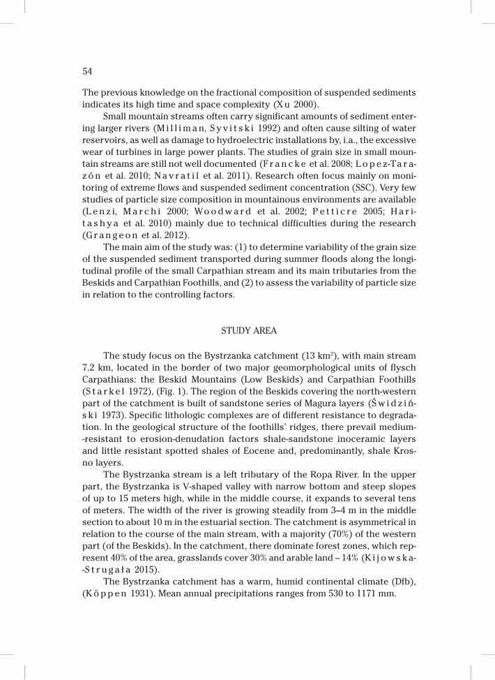
The study focus on the Bystrzanka catchment (13 km2), with main stream
7.2 km, located in the border of two major geomorphological units of flysch
Carpathians: the Beskid Mountains (Low Beskids) and Carpathian Foothills
(S t a r k e l 1972), (Fig. 1). The region of the Beskids covering the north-western
part of the catchment is built of sandstone series of Magura layers (Ś w i d z i ń-
s k i 1973). Specific lithologic complexes are of different resistance to degrada-
tion. In the geological structure of the foothills’ ridges, there prevail medium-
-resistant to erosion-denudation factors shale-sandstone inoceramic layers
and little resistant spotted shales of Eocene and, predominantly, shale Kros-
no layers.
The Bystrzanka stream is a left tributary of the Ropa River. In the upper
part, the Bystrzanka is V-shaped valley with narrow bottom and steep slopes
of up to 15 meters high, while in the middle course, it expands to several tens
of meters. The width of the river is growing steadily from 3–4 m in the middle
section to about 10 m in the estuarial section. The catchment is asymmetrical in
relation to the course of the main stream, with a majority (70%) of the western
part (of the Beskids). In the catchment, there dominate forest zones, which rep-
resent 40% of the area, grasslands cover 30% and arable land – 14% (K i j o w s k a-
-S t r u g a ł a 2015).
The Bystrzanka catchment has a warm, humid continental climate (Dfb),
(K ö p p e n 1931). Mean annual precipitations ranges from 530 to 1171 mm.
55
Fig. 1. Location of the Bystrzanka catchment and the measurements points
56
RESEARCH METHODS
The samples of water of a capacity of 1 dm3 were taken during the nine sum-
mer floods in 2010 and 2011 using a bottle bathometer along the longitudinal pro-
file of the main Bystrzanka stream and its tributaries. In the Bystrzanka stream
samples were collected at the stream gauge (estuarial section of the stream)
and also at 990 m and 2700 m distance from the stream gauge in the direction
the stream source. In addition, there was analysed the fractional composition
for one tributary from the Beskids and Carpathian Foothills. The water samples
were always collected in the same part of the stream channel, in the current
of the stream, at the same depth below the water surface. The frequency of wa-
ter sampling during floods was dependent on rapidity of the water level changes.
The water samples were filtered, oven dried (105ºC), and weighed to deter-
mine the concentration of suspended sediment (SSC). The fractional composition
of the suspended material in 47 samples was determined by laser diffraction us-
ing a Fritsch Analysette 22 diffractometer. Sedimentological indicators: the mean
grain diameter in the phi scale (Mz) and standard deviation (σ1) were calculated
using the Folk and Ward (1957) method. There was adopted the following classi-
fication of grain sizes: medium sand (0.5–0.25 mm); fine sand (0.25–0.1 mm); very
fine sand (0.1–0.05 mm); coarse silt (0.05–0.02 mm); fine silt (0.02–0.002 mm); clay
(<0.002 mm) (P o l i s h S o c i e t y… 2008).
RESULT AND DISCUSSION
SPATIAL VARIABILITY OF SUSPENDED SEDIMENT GRAIN SIZE
In order to determine the dominant type of graining of the suspended sedi-
ment, there was calculated the percentage of the basic fractions. In the estuarial
section of Bystrzanka stream, in water samples collected during the floods, there
dominated the silt fraction (0.05–0.002 mm), representing 80% of the material
transported in suspension, with the highest percentage of fine silt (0.02–0.002),
which accounted for 62%. The clay fraction accounted for 8.6% of the material.
Such fractional composition is typical for rivers in the Beskids (F r o e h l i c h
1982). Based on the values of the variation rate, it can be noted that the fine
sand fraction, along the longitudinal profile of Bystrzanka stream, underwent the
greatest changes (Cv = 76%), while the smallest changes occurred in the case
of the fine silt (Cv = 9%) (Table 1). The grain size distribution did not vary much
and the d50 ranged from 0.015 (during the rising limb) to 0.014 mm (during the
falling limb).
The spatial variation of percentage of the fine silt fraction was the highest
in samples taken from the tributary from the Carpathian Foothills part of the
catchment (68%) and the lowest – in the samples taken from the middle section
57
of Bystrzanka stream (Table 2). The coarse silt, in Bystrzanka stream before the
mouth of the Beskids’ tributary (measurement point number 2) accounted for
23% and was the highest average percentage in comparison to all other sampling
points. The lowest very fine silt percentage, just as the sand percentage, was not-
ed in the tributary from the Carpathian Foothills’ part of the catchment. The clay
fraction percentage in this part of the catchment was the highest. It was also ob-
served a dependence of a percentage decline of the sand fraction and an increase
in the content of the fine silt with increasing catchment area (Table 2). Similar
patterns were observed in the Beskid Sądecki (F r o e h l i c h 1982). This should
be associated with reduced course slope of and water velocity. By sorting, finer
grains are involved in the transport much faster and at a greater distance than
coarse grains (A l l e n 1965). According to K o s t r z e w s k i et al. (1994) the per-
centage increase in the amount of finer grains in the longitudinal profile was as
Ta b l e 1
The average content [%] of each fraction of suspended sediment in samples taken in the estu-
ary section of Bystrzanka stream (water gauge near Research Station in Szymbark: measurement
point number 5)
Fraction Fine sand Very fine sand Coarse silt Fine silt Clay
[mm] 0.25–0.1 0.1–0.05 0.05–0.02 0.02–0.002 <0.002
The average contain (%) 3.0 5.3 20.9 62.2 8.6
Standard deviation (SD) 2.3 2.9 2.7 5.4 1.5
Coefficient of variation
(CV) [%]75.9 53.7 12.9 8.7 17.7
Ta b l e 2
The average content [%] of each fraction of suspended sediment in samples taken in the Bystrzan-
ka catchment
Place
of sampling
Grain size
[mm]
Tributary
from the
Carpathian
Foothills
(point 4)
Beskids'
tributary
(point 1)
Bystrzanka
stream
before
Beskids
tributary
(point 2)
Bystrzanka
stream after
Beskids
tributary
(point 3)
Bystrzanka
stream
water gauge
(point 5)
Medium sand (0.5–0.25) 0.0 0.0 0.0 0.0 0.1
Fine sand (0.25–0.) 0.8 2.0 3.2 2.9 3.0
Very fine sand (0.1–0.0) 3.6 4.6 6.4 5.7 5.3
Coarse silt (0.05–0.002) 18.0 20.6 22.9 21.7 20.9
Fine silt (0.02–0.002) 67.7 63.4 59.8 60.9 62.3
Clay (<0.002) 9.9 9.4 7.7 8.8 8.4
Sum 100.0 100.0 100.0 100.0 100.0
58
a result of the sorting process and processes of mechanical grain disintegration.
In the Bystrzanka stream, the percentage of each fraction in flooding is closer to
the fractional composition recorded in the Beskidy Mountains of Carpathians.
This indicates a greater impact of the Beskids’ tributaries than of the tributaries
of Carpathian Foothills on the development of floods in the Bystrzanka stream
and delivery of the material.
In the phi scale, there was also determined the standard deviation (δ1) ac-
cording to R.L. F o l k and W.C. Wa r d (1957). The material collected during the
floods in 2010 and 2011 was marked by poor sorting (on average: 1.66), except
for one sample in Bystrzanka stream during the September flood in 2010, when
the material was very poorly sorted and the sand fraction was then up to 28%,
which may indicate an anthropogenic origin of the material from the areas cov-
ered by stabilization works in the channel after a large flood which was record-
ed in June 2010 (K i j o w s k a-S t r u g a ł a 2012). The mean grain diameter (Mz)
Fig. 2. The percentage of selected fractions of the suspended sediment at a certain discharge in the
rising and falling limb in Bystrzanka stream
59
in the water gauge profile of Bystrzanka stream was 6.39, while in the tributary
part of the Beskids and Carpathian Foothills it was 6.50.
There was also carried out an analysis of the grain size of samples taken
during rising and decreasing limb of the flood in the estuarial part of the stream
(near water gauge). The studies have shown that in the rising limb phase, with
increasing discharge rate the sand percentage decreases and the finer fraction
percentage, of silt and clay, increases. A strong turbulence in the initial rising limb
phase facilitates maintaining the sand fraction in suspension. During the decreas-
ing limb, this relationship is reversed (Fig. 2). Similar patterns have been observed
in a small catchment in the UK (S l a t t e r y, B u r t 1997). The higher sand content
in the initial rising limb phase may result in redeposition of the material in the
channel. At the same time, in Bystrzanka stream, it has been found that for the
same discharge, the sand fraction content in the rising limb phase has a higher
percentage than in the falling limb vice versa in the case of the finest fraction.
This is due to falling of larger grains at the time of reducing the discharge. An ex-
ample is the flood of June 2010, when, during the increasing discharge, there was
recorded a higher percentage of sand fraction (8%) than in the decreasing phase
(4%), unlike the finest clay fraction. High SSC values recorded during the flood,
increased the viscosity of water which, together with considerable turbulence,
helped to maintain sand and silt particles in suspension. The final flood phases
were marked by little SSC, despite the intense grey-brown colour indicating a rel-
atively large amount of the colloidal fraction. During the flood of 31.08–1.09.2010
r., in the rising limb phase, there was recorded the highest sand fraction, 28%. The
maximum discharge was 5.1 m3s–1, and the maximum daily rainfall was 42 mm.
W. F r o e h l i c h (1982) noted a similar sand fraction percentage (35%) in the
mountain stream during floods caused by torrential downpours. The high sand
fraction in the stream during this flood indicates an allochthonous origin of the
material. The material could be the result of engineering works aimed at strength-
ening selected, significantly transformed sections of the Bystrzanka course,
damaged during the floods in May and June 2010. In addition, the high sand
content can indicate that the material derives from cleared roadside ditches.
The studies in other small catchments show a temporal variation of frac-
tional composition during the individual floods (S l a t t e r y, B u r t 1997). Such
variability has been attributed to temporal variations in the nature and efficien-
cy of the sediment delivery processes operating during storms, the importance
of particular sediment sources, and the operation of in-stream processes.
IMPLICATIONS OF CHANGES IN FRACTIONAL COMPOSITION
The study of correlation between particular fractions, as well as hydro-me-
teorological parameters in the estuarial section of Bystrzanka stream helped to
identify some statistically significant relationships (Table 3). With the increase
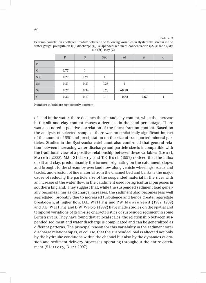
60
of sand in the water, there declines the silt and clay content, while the increase
in the silt and clay content causes a decrease in the sand percentage. There
was also noted a positive correlation of the finest fraction content. Based on
the analysis of selected samples, there was no statistically significant impact
of the amount of SSC and precipitation on the size of transported mineral par-
ticles. Studies in the Bystrzanka catchemnt also confirmed that general rela-
tion between increasing water discharge and particle size is incompatible with
the traditional view of a positive relationship between these variables (L e n z i,
M a r c h i 2000). M.C. S l a t t e r y and T.P. B u r t (1997) noticed that the influx
of silt and clay, predominantly the former, originating on the catchment slopes
and brought to the stream by overland flow along vehicle wheelings, roads and
tracks; and erosion of fine material from the channel bed and banks is the major
cause of reducing the particle size of the suspended material in the river with
an increase of the water flow, in the catchment used for agricultural purposes in
southern England. They suggest that, while the suspended sediment load gener-
ally becomes finer as discharge increases, the sediment also becomes less well
aggregated, probably due to increased turbulence and hence greater aggregate
breakdown, at higher flow. D.E. Wa l l i n g and P.W. M o o r e h e a d (1987, 1989)
and D.E. Wa l l i n g and B.W. We b b (1992) have made studies on the spatial and
temporal variations of grain-size characteristics of suspended sediment in some
British rivers. They have found that at local scales, the relationship between sus-
pended sediment and water discharge is complicated and can be generalized as
different patterns. The principal reason for this variability in the sediment size/
discharge relationship is, of course, that the suspended load is affected not only
by the hydraulic conditions within the channel but also by the dynamics of ero-
sion and sediment delivery processes operating throughout the entire catch-
ment (S l a t t e r y, B u r t 1997).
Ta b l e 3
Pearson correlation coefficient matrix between the following variables in Bystrzanka stream in the
water gauge: precipitaion (P); discharge (Q); suspended sediment concentration (SSC); sand (Sd);
silt (St); clay (C)
P Q SSC Sd St C
P 1
Q 0.77 1
SSC 0.27 0.71 1
Sd –0.31 –0.31 –0.23 1
St 0.27 0.34 0.26 –0.98 1
C 0.33 0.17 0.10 –0.82 0.67 1
Numbers in bold are significantly different.
61
In the Beskids’ tributary to Bystrzanka, unlike to main stream, there was
a statistically significant, p<0.05, relationship between SSC and clay and sand
fractions. A positive correlation was noted for clay, while for sand it was negative.
CONCLUSIONS
The analysis of fractional composition of the suspended material, collected
during the summer floods in 2010–2011 (nine floods) along the longitudinal pro-
file of the Bystrzanka stream and its tributaries from the Beskids and Carpathian
Foothills showed that:
– the silt fraction is the dominant material transported during floods. The
average content of the fraction varies from 67 to 88% along the longitudinal
profile of the main stream, from 82 to 86% in the Beskids’ tributary and from
80 to 86% in the Carpathian Foothills’ tributary;
– the highest standard deviation was recorded in relation to the sand frac-
tion (Bystrzanka stream – the longitudinal profile – 58%, the Beskids’ and
Carpathian Foothills’ tributaries – 42%). The high sand content in the main
stream resulted from the human activity (stabilization channel works) with-
in the stream channel;
– in the Beskids’ tributary, on average, there was recorded a higher content
of the sand fraction and lower content of the silt and clay fraction in com-
parison to the Carpathian Foothills’ tributary;
– along with the course of the main stream, there was no statistically signifi-
cant changes in the fractional composition of the suspended material;
– in the estuarial section of the main stream, there was observed a statistical-
ly significant (<0.05) inverse relationship between the sand and silt fraction
and the sand and clay fraction as well as no statistically significant influence
of factors controlling summer floods on the size of suspended sediment;
– during the rising limb phase, the sand fraction content showed a higher
percentage content (in the same water level), than during the falling limb
and contrary in the case of the finest fraction.
Institute of Geography and Spatial Organisation PAS
Research Station in Szymbark
38-311 Szymbark 430, Poland
e-mail: [email protected]
REFERENCES
A l l e n J.R.L., 1965. A review of the origin and characteristics of recent alluvial sediments. Sedimen-
tology 5, 89–191.
B o g e n J., 1992. Monitoring grain size of suspended sediments in rivers. Erosion and Sediment Trans-
port Monitoring Programmes in River Basin, Proceedings of Oslo Symposium, August, IAHS
210, 183–190.
62
F o l k R.L., Wa r d W.C., 1957. Brazos River bar: a study in the significance of grain size parameters.
Journal of Sedimentary Petrology 27, 3–26.
F o s t e r I.D.L., C h a r l e s w o r t h S.M., 1996 1996. Heavy metals in the hydrological cycle: trends and
explanation. Hydrolological Processes 10, 2, 227–261.
F r a n c k e T., L o p e z-Ta r a z ó n J.A., Ve r i c a t D., B r o n s t e r t A., B a t a l l a R.J., 2008. Flood-based
analysis of high magnitude sediment transport using a non-parametric method. Earth Surface Pro-
cesses and Landforms 33, 2064–2077.
F r o e h l i c h W., 1982. Mechanizm transportu fluwialnego i dostawy zwietrzelin do koryta w górskiej
zlewni fliszowej. Prace Geograficzne IGiPZ PAN 143, 1–144.
G r a n g e o n T., L e g o u t C., E s t e v e s M., G r a t i o t N., N a v r a t i l O., 2012. Variability of the par-
ticle size of suspended sediment during highly concentrated flood events in a small mountainous
catchment. Journal of Soils and Sediments 12(10), 1549–1558.
H a r i t a s h y a U.K., K u m a r A., S i n g h P., 2010. Particle size characteristics of suspended sediment
transported in meltwater from the Gangotri Glacier, central Himalaya—an indicator of subglacial
sediment evacuation. Geomorphology 122, 140–152.
K i j o w s k a-S t r u g a ł a M., 2012. The role of downpours in transformation of slopes in the Polish Car-
pathian Foothills. Studia Geomorphologica Carpatho-Balcanica 45, 67–85.
K i j o w s k a-S t r u g a ł a M., 2015. Transport zawiesiny w warunkach zmieniającej się antropopresji
w zlewni Bystrzanki (Karpaty Fliszowe). Prace Geograficzne IGiPZ PAN 247, 1–140.
K ö p p e n W., 1931. Grundriss der Klimakunde. Walter de Gruyter, 1–388.
K o s t r z e w s k i A., M a z u r e k A., Z w o l i ń s k i Z., 1994. Dynamics of fluvial transport of the upper
Parsęta River as a response of the catchment system. Wydawnictwo Bogucki, Poznań.
L e n z i M.A., M a r c h i L., 2000. Suspended sediment load during floods in a small stream of the Dolo-
mites (northeastern Italy). Catena 39, 267–282.
L o p e z-Ta r a z ó n J.A., B a t a l l a R.J., Ve r i c a t D., B a l a s c h J.C., 2010. Rainfall, runoff and sedi-
ment transport relations in a mesoscale mountainous catchement: The River Isábena (Ebro ba-
sin). Catena 82, 23–34.
M e h a r g A.A., Wr i g h t J., L e e k s G.J., Wa s s P.D., O s b o r n D., 1999. Temporal and spatial patterns
in α-and γ-hexachlorocyclohexane concentrations in industrially contaminated rivers. Environ-
mental Science and Technology 33, 12, 2001–2006.
M i l l i m a n J.D., S y v i t s k i J.P., 1992. Geomorphic/tectonic control of sediment discharge to the ocean:
the importance of small mountainous rivers. Journal of Geology 100, 525–544.
N a v r a t i l O., E s t e v e s M., L e g o u t C., G r a t i o t N., N e m e r y J., W i l l m o r e S., G r a n g e o n T.,
2011. Global uncertainty analysis of suspended sediment monitoring using turbidimeter in a small
mountainous river catchment. Journal of Hydrology 398, 246–259.
P e t t i c r e E.L., 2005. The composite nature of suspended and gravel stored fine sediment in streams:
a case study of O’Ne-eil Creek, British Columbia, Canada. [in:] I.G. Droppo, G.G. Leppard,
S.N. Liss, T.M. Milligan (eds.), Flocculation in natural and engineered environmental systems.
CRC Press, Boca Raton, FL. 71–93.
P o l i s h S o c i e t y of Soil Science, 2008. Particle size distribution and textural classes of soils and min-
eral materials. Roczniki Gleboznawcze 60, 2, 5–16.
R u s s e l l M.A., Wa l l i n g D.E., H o d g k i n s o n R.A., 2001. Suspended sediment sources in two small
lowland agricultural catchments in the UK. Journal of Hydrology 252, 1, 1–24.
S l a t t e r y M.C., B u r t T.P., 1997. Particle size characteristics of suspended sediment in hillslope runoff
and stream flow. Earth Surface Processes and Landforms 22, 8, 705–719.
S t a r k e l L., 1972. The characteristics of the Polish Carpathians relief (and its importance for human
economy). Problemy Zagospodarowania Ziem Górskich 10, 75–150.
Ś w i d z i ń s k i H., 1973. Z badań geologicznych w Karpatach. Geographical Studies IG PAN 80, 11–62.
Wa l l i n g D.E., M o o r e h e a d P.W., 1987. Spatial and temporal variation of the particle-size character-
istics of fluvial suspended sediment. Geografiska Annaler A 69, 47–59.
Wa l l i n g D.E., M o o r e h e a d P.W., 1989. The particle size characteristics of fluvial suspended sedi-
ment: an overview. Hydrobiologia 176(177), 125–149.

63
Wa l l i n g D.E., We b b B.W., 1992. Water quality 1: Physical characteristics. [in:] P. Calow, G.E. Petts
(eds.), The rivers handbook. Vol. 21, Blackwell Scientific, Oxford, 1, 48–72.
W i l l i a m s N.D., Wa l l i n g D.E., L e e k s G.J.L., 2008. An analysis of the factors contributing to the set-
tling potential of fine fluvial sediment. Hydrological Processes 22, 4153– 4162.
Wo o d w a r d J.C., P o r t e r P.R., L o w e A.T., Wa l l i n g D.E., E v a n s A.J., 2002. Composite suspended
sediment particles and flocculation in glacial meltwaters: preliminary evidence from Alpine and
Himalayan basins. Hydrological Processes 16, 1735–1744.
X u J., 2000. Grain-size characteristics of suspended sediment in the Yellow River, China. Catena 38, 3,
243–263.