Embed Size (px)
Citation preview
Bulletin du centre d’études médiévalesd’Auxerre | BUCEMA
22.1 | 2018
Varia
Spatializing Meersen : Monasteries in JurassianBurgundy (6th-9th c.)
Jens Schneider
Electronic version
URL: http://journals.openedition.org/cem/15084DOI: 10.4000/cem.15084ISSN: 1954-3093
Publisher
Centre d'études médiévales Saint-Germain d'Auxerre
Electronic reference
Jens Schneider, « Spatializing Meersen : Monasteries in Jurassian Burgundy (6th-9th c.) », Bulletin ducentre d’études médiévales d’Auxerre | BUCEMA [Online], 22.1 | 2018, Online since 03 September 2018,connection on 19 April 2019. URL : http://journals.openedition.org/cem/15084 ; DOI : 10.4000/cem.15084
This text was automatically generated on 19 April 2019.
Les contenus du Bulletin du centre d’études médiévales d’Auxerre (BUCEMA) sont mis à disposition selonles termes de la Licence Creative Commons Attribution - Pas d’Utilisation Commerciale - Partage dansles Mêmes Conditions 4.0 International.
Spatializing Meersen : Monasteriesin Jurassian Burgundy (6th-9th c.)1
Jens Schneider
EDITOR'S NOTE
Cet article fait référence aux cartes 2, 5, 8, 9, 10, 11 et 12 du dossier cartographique. Ces
cartes sont réinsérées dans le corps du texte et les liens vers le dossier cartographique
sont donnés en documents annexes.
Introduction
Spatializing Meersen : Monasteries in Jurassian Burgundy (6th-9th c.)
Bulletin du centre d’études médiévales d’Auxerre | BUCEMA, 22.1 | 2018
1
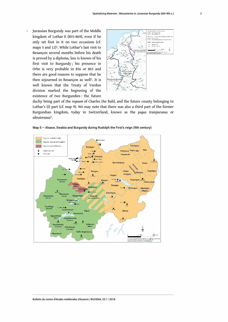
1 Jurassian Burgundy was part of the Middle
kingdom of Lothar II (855-869), even if he
only set foot in it on two occasions (cf.
maps 5 and 12)2. While Lothar’s last visit to
Besançon several months before his death
is proved by a diploma, less is known of his
first visit to Burgundy ; his presence in
Orbe is very probable in 856 or 863 and
there are good reasons to suppose that he
then sojourned in Besançon as well3. It is
well known that the Treaty of Verdun
division marked the beginning of the
existence of two Burgundies : the future
duchy being part of the regnum of Charles the Bald, and the future county belonging to
Lothar’s (I) part (cf. map 9). We may note that there was also a third part of the former
Burgundian kingdom, today in Switzerland, known as the pagus transjuranus or
ultraioranus4.
Map 5 – Alsace, Swabia and Burgundy during Rudolph the First’s reign (9th century)
Spatializing Meersen : Monasteries in Jurassian Burgundy (6th-9th c.)
Bulletin du centre d’études médiévales d’Auxerre | BUCEMA, 22.1 | 2018
2
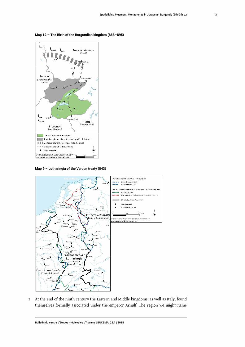
Map 12 – The Birth of the Burgundian kingdom (888–895)
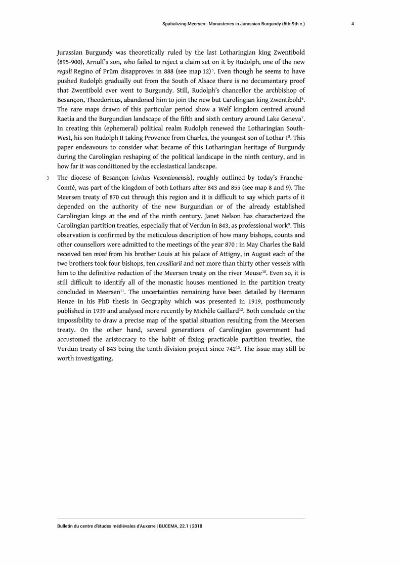
Map 9 – Lotharingia of the Verdun treaty (843)
2 At the end of the ninth century the Eastern and Middle kingdoms, as well as Italy, found
themselves formally associated under the emperor Arnulf. The region we might name
Spatializing Meersen : Monasteries in Jurassian Burgundy (6th-9th c.)
Bulletin du centre d’études médiévales d’Auxerre | BUCEMA, 22.1 | 2018
3
Jurassian Burgundy was theoretically ruled by the last Lotharingian king Zwentibold
(895-900), Arnulf’s son, who failed to reject a claim set on it by Rudolph, one of the new
reguli Regino of Prüm disapproves in 888 (see map 12)5. Even though he seems to have
pushed Rudolph gradually out from the South of Alsace there is no documentary proof
that Zwentibold ever went to Burgundy. Still, Rudolph’s chancellor the archbishop of
Besançon, Theodoricus, abandoned him to join the new but Carolingian king Zwentibold6.
The rare maps drawn of this particular period show a Welf kingdom centred around
Raetia and the Burgundian landscape of the fifth and sixth century around Lake Geneva7.
In creating this (ephemeral) political realm Rudolph renewed the Lotharingian South-
West, his son Rudolph II taking Provence from Charles, the youngest son of Lothar I8. This
paper endeavours to consider what became of this Lotharingian heritage of Burgundy
during the Carolingian reshaping of the political landscape in the ninth century, and in
how far it was conditioned by the ecclesiastical landscape.
3 The diocese of Besançon (civitas Vesontionensis), roughly outlined by today’s Franche-
Comté, was part of the kingdom of both Lothars after 843 and 855 (see map 8 and 9). The
Meersen treaty of 870 cut through this region and it is difficult to say which parts of it
depended on the authority of the new Burgundian or of the already established
Carolingian kings at the end of the ninth century. Janet Nelson has characterized the
Carolingian partition treaties, especially that of Verdun in 843, as professional work9. This
observation is confirmed by the meticulous description of how many bishops, counts and
other counsellors were admitted to the meetings of the year 870 : in May Charles the Bald
received ten missi from his brother Louis at his palace of Attigny, in August each of the
two brothers took four bishops, ten consiliarii and not more than thirty other vessels with
him to the definitive redaction of the Meersen treaty on the river Meuse10. Even so, it is
still difficult to identify all of the monastic houses mentioned in the partition treaty
concluded in Meersen11. The uncertainties remaining have been detailed by Hermann
Henze in his PhD thesis in Geography which was presented in 1919, posthumously
published in 1939 and analysed more recently by Michèle Gaillard12. Both conclude on the
impossibility to draw a precise map of the spatial situation resulting from the Meersen
treaty. On the other hand, several generations of Carolingian government had
accustomed the aristocracy to the habit of fixing practicable partition treaties, the
Verdun treaty of 843 being the tenth division project since 74213. The issue may still be
worth investigating.
Spatializing Meersen : Monasteries in Jurassian Burgundy (6th-9th c.)
Bulletin du centre d’études médiévales d’Auxerre | BUCEMA, 22.1 | 2018
4
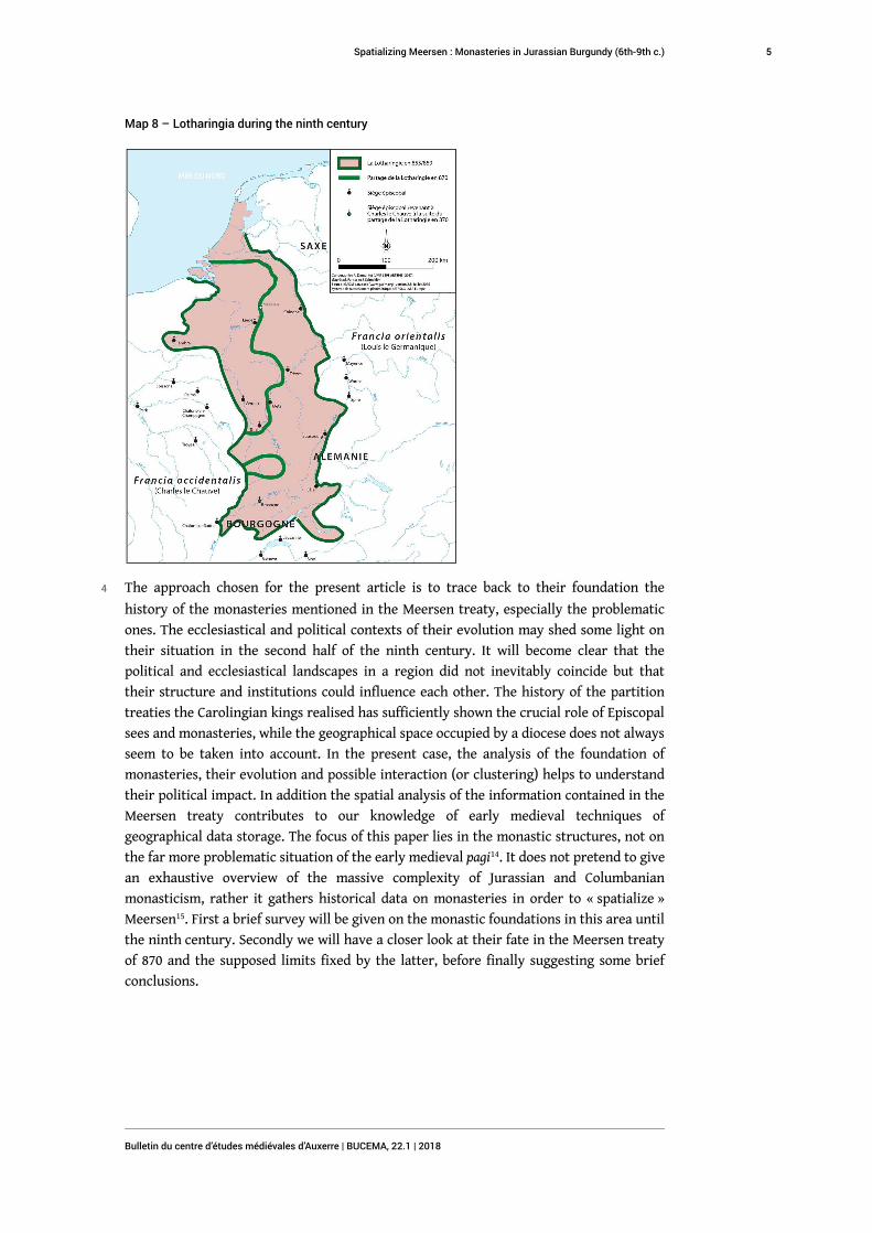
Map 8 – Lotharingia during the ninth century
4 The approach chosen for the present article is to trace back to their foundation the
history of the monasteries mentioned in the Meersen treaty, especially the problematic
ones. The ecclesiastical and political contexts of their evolution may shed some light on
their situation in the second half of the ninth century. It will become clear that the
political and ecclesiastical landscapes in a region did not inevitably coincide but that
their structure and institutions could influence each other. The history of the partition
treaties the Carolingian kings realised has sufficiently shown the crucial role of Episcopal
sees and monasteries, while the geographical space occupied by a diocese does not always
seem to be taken into account. In the present case, the analysis of the foundation of
monasteries, their evolution and possible interaction (or clustering) helps to understand
their political impact. In addition the spatial analysis of the information contained in the
Meersen treaty contributes to our knowledge of early medieval techniques of
geographical data storage. The focus of this paper lies in the monastic structures, not on
the far more problematic situation of the early medieval pagi14. It does not pretend to give
an exhaustive overview of the massive complexity of Jurassian and Columbanian
monasticism, rather it gathers historical data on monasteries in order to « spatialize »
Meersen15. First a brief survey will be given on the monastic foundations in this area until
the ninth century. Secondly we will have a closer look at their fate in the Meersen treaty
of 870 and the supposed limits fixed by the latter, before finally suggesting some brief
conclusions.
Spatializing Meersen : Monasteries in Jurassian Burgundy (6th-9th c.)
Bulletin du centre d’études médiévales d’Auxerre | BUCEMA, 22.1 | 2018
5
Monasteries in the diocese of Besançon
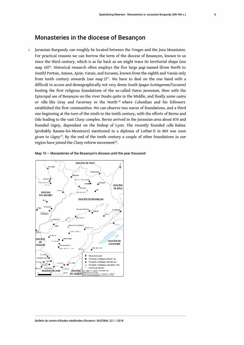
5 Jurassian Burgundy can roughly be located between the Vosges and the Jura Mountains.
For practical reasons we can borrow the term of the diocese of Besançon, known to us
since the third century, which is as far back as we might trace its territorial shape (see
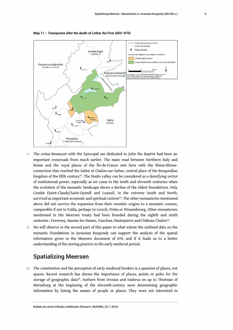
map 10)16. Historical research often employs the five large pagi named (from North to
South) Portois, Amous, Ajoie, Varais, and Escuens, known from the eighth and Varais only
from tenth century onwards (see map 2)17. We have to deal on the one hand with a
difficult to access and demographically not very dense South (pagus Scotingorum/Escuens)
hosting the first religious foundations of the so-called Patres Jurensium, then with the
Episcopal see of Besançon on the river Doubs quite in the Middle, and finally some castra
or villa like Gray and Faverney in the North 18 where Columban and his followers
established the first communities. We can observe two waves of foundations, and a third
one beginning at the turn of the ninth to the tenth century, with the efforts of Berno and
Odo leading to the vast Cluny complex. Berno arrived in the Jurassian area about 870 and
founded Gigny, dependant on the bishop of Lyon. The recently founded cella Balma
(probably Baume-les-Messieurs) mentioned in a diploma of Lothar II in 869 was soon
given to Gigny19. By the end of the tenth century a couple of other foundations in our
region have joined the Cluny reform movement20.
Map 10 – Monasteries of the Besançon’s diocese until the year thousand
Spatializing Meersen : Monasteries in Jurassian Burgundy (6th-9th c.)
Bulletin du centre d’études médiévales d’Auxerre | BUCEMA, 22.1 | 2018
6
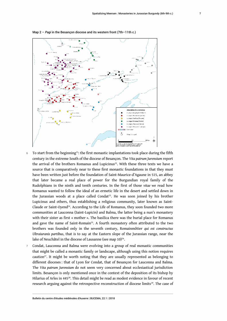
Map 2 – Pagi in the Besançon diocese and its western front (7th–11th c.)
6 To start from the beginning21: the first monastic implantations took place during the fifth
century in the extreme South of the diocese of Besançon. The Vita patrum Jurensium report
the arrival of the brothers Romanus and Lupicinus22. With these three texts we have a
source that is comparatively near to these first monastic foundations in that they must
have been written just before the foundation of Saint-Maurice-d’Agaune in 515, an abbey
that later became a real place of power for the Burgundian royal family of the
Rudolphians in the ninth and tenth centuries. In the first of those vitae we read how
Romanus wanted to follow the ideal of an ermetic life in the desert and settled down in
the Jurassian woods at a place called Condat23. He was soon joined by his brother
Lupicinus and others, thus establishing a religious community, later known as Saint-
Claude or Saint-Oyend24. According to the Life of Romanus, they soon founded two more
communities at Lauconna (Saint-Lupicin) and Balma, the latter being a nun’s monastery
with their sister as first « mother ». The basilica there was the burial place for Romanus
and gave the name of Saint-Romain25. A fourth monastery often attributed to the two
brothers was founded only in the seventh century, Romainmôtier qui est constructus
Ultraiuranis partibus, that is to say at the Eastern slope of the Jurassian range, near the
lake of Neuchâtel in the diocese of Lausanne (see map 10)26.
7 Condat, Lauconna and Balma were evolving into a group of real monastic communities
that might be called a monastic family or landscape, although using this notion requires
caution27. It might be worth noting that they are usually represented as belonging to
different dioceses : that of Lyon for Condat, that of Besançon for Lauconna and Balma.
The Vita patrum Jurensium do not seem very concerned about ecclesiastical jurisdiction
limits. Besançon is only mentioned once in the context of the deposition of its bishop by
Hilarius of Arles in 44528. This detail might be read as modest evidence in favour of recent
research arguing against the retrospective reconstruction of diocese limits29. The case of
Spatializing Meersen : Monasteries in Jurassian Burgundy (6th-9th c.)
Bulletin du centre d’études médiévales d’Auxerre | BUCEMA, 22.1 | 2018
7
Condat, but also that of Gigny (ninth c.), can be explained either by the fact that the
bishops of Lyon did not respect the spatial integrity of the province Maxima Sequanorum,
or by the absence of clearly defined diocese borderlines in less dense regions.
8 Condat grew into an economic and spiritual centre while Lauconna became its priory.
Balma seems to have disappeared and only resurfaced in the thirteenth century as
another priory of Condat30. These communities seem to have been influenced in one way
or another by Lérins, perhaps as a result of Mediterranean contacts mentioned by Gérard
Moyse, René Locatelli and Catherine Faure31. Later on, before adopting the Regula Benedicti
, there might also have been Columbanian influence, which leads us to the second family
of monastic houses. Jonas of Bobbio tells us the main facts about it in his Vita Columbani
abbatis32. There were three monasteries founded by Columban by the end of the sixth
century : Annegray, Fontaine and Luxeuil33. Nearly two centuries later, two of them have
become priories of Luxeuil, thus asserting the central position of the North of Burgundy
in the Carolingian period and thereafter.
9 To this Columbanian family one could adjoin Cusance, over the Doubs valley, the already
mentioned monastery of Romainmôtier (diocèse de Lausanne) and two other houses just
outside of the city of Besançon, Saint-Paul and Sainte-Marie. The four of them were
founded in the first half of the seventh century, at least three of them by the same family.
We can recognise here, for the first time, a ducal family in this Burgundian region that
later went under Frankish domination during the seventh century, even if it retained a
certain autonomy for some time due to a gallo-roman aristocracy there34. Even still,
around 640 Jonas of Bobbio tells us about a dux Waldelenus and his son Chramnelenus
following him in eius honore, so we might view them as dukes under Frankish rule in the
Jurassian Burgundy as well as in the pagus transjuranus35.
10 Waldelenus and his wife Flavia met Columban and following this encounter they had a
son, whom Columban baptized with the name of Donatus36. This Donatus became bishop
of Besançon and founded the monastery of Saint-Paul quem Palatium nuncupant ob veterum
monimenta murorum37, that is to say on the remains of a Roman palatial building. The
second son of Waldelenus and Flavia was the previously mentioned Chramnelenus, who
probably founded Romainmôtier which became an important abbey of the Rudolphian
kings in the tenth century38. They later had two daughters for whom Flavia with her son
Donatus founded a women’s monastery, the second monastic house outside Besançon :
Jussamoutier or Sainte-Marie. It is of minor importance for our purpose if we label
Waldelenus and his children as « gallo-roman » or as « neustrian » while we bear in mind
that they undeniably supported the Columbanian monasticism which was something new
in Burgundy39. As Karl Weber has pointed out, it is thanks to this ducal family and to the
institutions they founded or appropriated for themselves that Besançon became a central
place for our Jurassian area during the seventh century and for the transjurane Burgundy
as well. Donatus and Waldelenus thus contributed to the genesis of a coherent space on
both sides of the Jurassian mountains, a Jurassian region that would become the spatial
basis of the Rudolphian kingdom (cf. map 5 and 11)40. The monasteries have been
described as elements of a material and spiritual colonisation in this evolution of the
seventh century41.
Spatializing Meersen : Monasteries in Jurassian Burgundy (6th-9th c.)
Bulletin du centre d’études médiévales d’Auxerre | BUCEMA, 22.1 | 2018
8
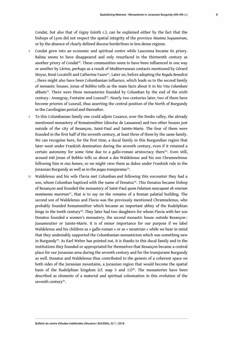
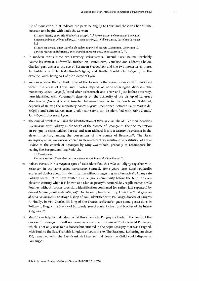
Map 11 – Transjurane after the death of Lothar the First (850–870)
11 The civitas Besançon with the Episcopal see dedicated to John the Baptist had been an
important crossroads from much earlier. The main road between Northern Italy and
Reims and the royal places of the Île-de-France met here with the Rhine-Rhone-
connection that reached the Saône at Chalon-sur-Saône, central place of the Burgundian
kingdom of the fifth century42. The Doubs valley can be considered as a densifying vector
of institutional power, especially as we come to the tenth and eleventh centuries when
the evolution of the monastic landscape shows a decline of the oldest foundations. Only
Condat (Saint-Claude/Saint-Oyend) and Luxeuil, in the extreme South and North,
survived as important economic and spiritual centres43. The other monasteries mentioned
above did not survive the expansion from their eremitic origins to a monastic cosmos,
comparable if not to Fulda, perhaps to Lorsch, Prüm or Wissembourg. Other monasteries
mentioned in the Meersen treaty had been founded during the eighth and ninth
centuries : Faverney, Baume-les-Dames, Vaucluse, Hautepierre and Château-Chalon44.
12 We will observe in the second part of this paper to what extent the outlined data on the
monastic foundations in Jurassian Burgundy can support the analysis of the spatial
information given in the Meersen document of 870, and if it leads us to a better
understanding of the storing practice in the early medieval period.
Spatializing Meersen
13 The constitution and the perception of early medieval borders is a question of places, not
spaces. Recent research has shown the importance of places, points or poles for the
storage of geographic data45. Authors from Orosius and Isidorus on up to Thietmar of
Merseburg at the beginning of the eleventh century were determining geographic
information by listing the names of people or places. They were not interested in
Spatializing Meersen : Monasteries in Jurassian Burgundy (6th-9th c.)
Bulletin du centre d’études médiévales d’Auxerre | BUCEMA, 22.1 | 2018
9

describing the extent of areas through the use of borderlines. This becomes particularly
clear in reading the Meersen treaty that above all uses the names of Episcopal sees and
monasteries to indicate the areas annexed by Charles and Louis. This treaty is one of the
rare sources during the early middle ages that provides us with precise information about
two aspects : first how people managed spatial problems like the geographical definition
of a zone of political influence (regnum) – what French historiography has become used to
call pratiques spatiales –, and second, the way they saved and stored spatial data, in other
words what kind of storage medium (Speichermedium) they used46.
14 To sum up the overview on the monastic foundations in the diocese of Besançon, we are
dealing with 18 communities before 900, among them at least four chapters and cellae,
and the cathedral chapter of St John the Baptist. More than half of these institutions can
be identified in the Meersen treaty47: eight for Louis the German, three for Charles the
Bald being the cathedral chapter and two monasteries at Besançon extra muros. This
proportion more or less reflects the evidence of the text enumerating two thirds of the
Lotharingian kingdom for Louis and one third for his younger brother, a relation that
does not necessarily represent the territorial partition, but rather the cited place names48
. The remaining dozen or so monasteries represent smaller houses, partly dependent on
the more important ones.
15 We are used to thinking of the Meersen treaty as one in a long line of division treaties
that marked the Carolingian period. Verdun was not the first one and Meersen was not
the last. It may be worth remembering that the partition enacted at Meersen was the
result of secret negotiations between Louis and Charles on how to proceed in the case of
the death of their nephew Lothar II49. As Lothar obediently died in 869 the division project
was realised and can neatly be reconstructed. The Meersen division cut through the
diocese of Besançon, leaving to Charles the Bald the civitas proper, with the suburban
abbeys of Brégille and Sainte-Marie and, to be added, Saint-Paul, not mentioned in the
treaty. Shortly after, Saint-Martin-de-Brégille was given to the archbishop Arduicus of
Besançon by King Charles50. For his part, Louis the German received, following the
traditional point of view that we find on the maps, the South of the diocese.
16 Unlike the Verdun treaty of 843, the Meersen treaty is conserved in several copies edited
in the MGH Capitularia collection ; moreover, we can rely on the personal account of the
diplomatic exchanges by Hincmar of Reims51. Using this information, historians and
geographers have tried to learn more about the Verdun treaty in the hope of re-
constructing the borders between the Middle kingdom of Lothar and of Western and
Eastern Francia52. Utilizing a spatial reading of the text reveals some problems, especially
concerning Frisia, in the North, and the Rhinelands, in the North-East53. The different
interpretations have produced a quantity of maps representing the political situation in
843 ; map 9 suggests a synoptic view of the most important among them.
17 The geographical extension of the so-called Francia Media created in 843 as the kingdom
of Lothar I goes further southward until Italy. In 855, the northern part remaining with
Lothar II still points a sole finger out West of the Rhône to reach the Mediterranean.
However Lothar († 869) and the last Lotharingian king Zwentibold († 900) exchanged or
gave up these difficult to control regions so that by the end of the ninth century the
Jurassian Burgundy, the see of Besançon and even the South of Alsace are disputed
between Zwentibold and Rudolph (map 5, 11 and 12)54. Before being claimed as part of the
Burgundian kingdom by Rudolph in 888 this region is already partitioned between
Charles the Bald and Louis the German. With the Meersen treaty we dispose of a proper
Spatializing Meersen : Monasteries in Jurassian Burgundy (6th-9th c.)
Bulletin du centre d’études médiévales d’Auxerre | BUCEMA, 22.1 | 2018
10
list of monasteries that indicate the parts belonging to Louis and those to Charles. The
Meersen text begins with Louis the German :
Est haec divisio, quam sibi Hludowicus accepit. […] Faverniacum, Polemniacum, Luxovium,Luteram, Balmam, Offonis-villam, […] Altam-petram, […] Vallem-Clusae, Castellum Carnones[…]Et haec est divisio, quam Karolus de eodem regno sibi accepit. Lugdunum, Vesontium, […]Sanctae Mariae in Bisintiono, Sancti Martini in eodem loco, Sancti Augentii […]55.
18 In modern terms these are Faverney, Polemniacum, Luxeuil, Lure, Baume (probably
Baume-les-Dames), Enfonvelle, further on Hautepierre, Vaucluse and Château-Chalon.
Charles’ part encloses the see of Besançon (Vesontium) and the two monasteries there,
Sainte-Marie and Saint-Martin-de-Brégille, and finally Condat (Saint-Oyend) in the
extreme South, being part of the diocese of Lyon.
19 We can observe that at least three of the former Lotharingian monasteries mentioned
within the areas of Louis and Charles depend of non-Lotharingian dioceses. The
monastery Sancti Gangulfi, listed after Echternach and Trier and just before Faverney,
here identified with Varennes56, depends on the authority of the bishop of Langres ;
Montfaucon (Montemfalconis), inserted between Uzès far in the South and St-Mihiel,
depends of Reims ; the monastery Sancti Augentii, mentioned between Saint-Martin-de-
Brégille and Saint-Marcel near Chalon-sur-Saône can be identified with Saint-Claude/
Saint-Oyend, diocese of Lyon.
20 The crucial problem remains the identification of Polemniacum. The MGH edition identifies
Polemniacum with Poligny in the South of the diocese of Besançon57. The documentation
on Poligny is scant. Michel Parisse and Jean Richard locate a castrum Poloniacum in the
eleventh century among the possessions of the counts of Besançon58. The Series
archiepiscoporum Bisontinorum copied in eleventh century mention the restitution of a villa
Pauliaci to the church of Besançon by King Zwentibold, probably to recompense his
leaving the Burgundian King Rudolph.
32. Theodoricus.Per hunc restituit Zuentebolchus rex ecclesie sancti Stephani villam Pauliaci59.
21 Robert Parisot in his magnum opus of 1898 identified this villa as Poligny together with
Besançon in the same pagus Warascorum (Varais). Some years later René Poupardin
expressed doubts about this identification without suggesting an alternative60. At any rate
Poligny seems not to have existed as a religious community before the tenth or even
eleventh century when it is known as a Cluniac priory61. Bernard de Vrégille names a villa
Pouilley without further precision, identification confirmed (or rather just repeated) by
Gérard Moyse (Pouilley-les-Vignes)62. In the early tenth century, Louis the Child gave an
abbatia Pauliniacensis to Drogo bishop of Toul, identified with Poulangy, diocese of Langres63. Finally, in 914, Charles III, king of the Francia occidentalis, gave some possessions in
Poligny to Hugo « the Black » of Burgundy, son of count Richard and brother of the future
King Raoul64.
22 Map 10 can help to understand what this all entails. Poligny is clearly in the South of the
diocese of Besançon. It will not come as a surprise if Drogo of Toul received Poulangy,
which is not only near to his diocese but situated in the pagus Bassigny that was assigned,
with Toul, to the East-Frankish kingdom of Louis in 870. The Bassigny, Lotharingian since
855, remained with the East-Frankish kings so that Louis the Child could dispose of
Poulangy65.
Spatializing Meersen : Monasteries in Jurassian Burgundy (6th-9th c.)
Bulletin du centre d’études médiévales d’Auxerre | BUCEMA, 22.1 | 2018
11
23 A spatial reading of the Meersen treaty may tell us more about the disposition of the
place names. The text begins as follows with the places assigned to Louis66 : Cologne,
Trier, Utrecht, Strasbourg, Basel : these are the Episcopal sees. Thereafter, the abbeys :
Süsteren, Berg (Netherlands), Münstereifel (not far from Prüm), Chèvremont (Belgium),
Inda (Aachen), Saint-Maximin, Echternach, Horrea (near to Trier), thereafter Varennes,
Faverney, Polemniacum, Luxeuil, Lure, Baume, Enfonvelle. Then the description switches
to Lorraine : Moyenmoutier, Saint-Dié, Bonmoutier, Etival, Remiremont, – then to Alsace :
Murbach, Saint-Grégoire (Munster), Maursmünster, Ebersmünster, Honau, Masevaux,
Hohenburg (or Sainte-Odile), Saint-Etienne in Strasbourg, Erstein ; – finally we move to
today’s Switzerland : Solothurn and Moutier-Grandval, being still part of the diocese of
Basel ; – and here we are again in the diocese of Besançon : Hautepierre, Justinne (not
clearly identified67), Vaucluse, Château-Chalon.
24 The succession of the monasteries cited in the Meersen document seems obviously to
follow an inherent geographical logic. The description passes from the Rhinelands, quite
in the North, to the Moselle region with Echternach and Trier, then around the Southern
end of the Vosges – with our Columbanian monasteries – to pass on to Lorraine, Alsace,
the Basel region with Solothurn and Moutier-Grandval, to come back to the South of the
diocese of Besançon. The enigmatic Polemniacum fits well in the geographic
neighbourhood to Varennes, both of them being part of the pagus Bassigny. The Bassigny
(Basiniacum) is clearly listed among Louis’ parts in the Meersen treaty, as well as the pagi
of Basel (Basalchowa), Varais (Warasch), probably Escuens (Scudingum) and Amous (Emaus),
too. The fact that the description occasionally seems to jump from Varennes to Faverney
in the East, then to Polemniacum in the West, and back to Luxeuil and Lure does not
necessarily contradict this reading ; we can observe the same effect some lines further
between Hautepierre, Vaucluse and Château-Chalon. Even if we might detect spatial
patterns in early medieval texts as shown here through the example of the Meersen
treaty we do not necessarily understand every detail of the organisation of geographical
data. We can probably assume that the authors of these partition treaties did not
improvise but rather followed clearly set customs. Comparable patterns of spatial
organisation of place names have been observed throughout the cartularies of Prüm, of
Saint-Germain-des-Prés and of Wissemburg, being just another storage medium for
monastic geographical and administrative data68.
Conclusions
25 A spatial reading of the Meersen treaty from 870, taking into account the history of the
mentioned monastic houses suggests a revised tracing of the negotiated borderline
between the kingdoms of Charles the Bald and Louis the German – see map 8 for a
cartographical proposition. The place cited as Polemniacum is no longer identified with
Poligny but rather with Pauliniacum, or Poulangy, in the diocese of Langres. Consequently
there only remains a very modest part of Jurassian Burgundy for Charles the Bald,
granting him the pagus Portois (Portus). The Archiepiscopal see of Besançon, one out of
three in former Lotharingia, seems to represent an isolated exclave of Charles’ part : a
phenomenon already encountered with the important monastery of Saint-Vaast at the
treaty of Verdun in 843. It seems justified to deduce that the spatial design in our period
did not follow the modern ideal of proper spaces with linear borders as can be observed
with the political reshaping of Africa by the European powers in nineteenth century69.
Spatializing Meersen : Monasteries in Jurassian Burgundy (6th-9th c.)
Bulletin du centre d’études médiévales d’Auxerre | BUCEMA, 22.1 | 2018
12
Not only is the extension of Episcopal juridiction neglected but also the geographical
division experts did not hesitate to create politically isolated exclaves for their
administration. We may notice in passing that with the Waldelenus family enrooted at
Besançon we have an example of the duke-type as master of a region that Karl Ferdinand
Werner observed for the sixth and seventh century70.
26 From the Meersen document we can learn how geographical information was fixed and
stored. In the Carolingian period people did not indicate areas or territories but rather
they enumerated place names, episcopal sees and monasteries in most cases. Only in
addition to these did the authors of early medieval division treaties use river or county
names – diverging from the uses of charter production where the mention of pagus or
comitatus was systematic. Moreover, the disposition of the place names is not accidental.
27 There are modest clusters of early monastic foundations that cannot be explained with
the (still ambiguous) concept of a monastic landscape. The examples analysed here seem
to completely ignore the eventual delimitations of dioceses. We find the earliest
foundations of the so-called Patres Jurensium around the meeting point of the dioceses of
Lyon and Besançon : in eremo we might say. Two centuries later, the Columbanian
monasteries discussed here – one might add Remiremont and Moutiers-Grandval –
mainly cover the contact zone between the dioceses of Besançon, Toul and Basel.
Reçu : 27 juillet 2017 - Accepté : 14 juin 2018
APPENDIXES
Appendix : Treaty of Meersen
Capitularia regum Francorum, éd. A. BORETIUS et V. KRAUSE, Monumenta Germaniae historica,
Leges, 2.2, t. 2, Hannover, 1897, n° 251 : Divisio regni Hlotharii II. 870 Aug. 8, p. 193-195
Est haec divisio, quam sibi Hludowicus accepit. Coloniam, Treveris, Utrech, Stratsburch,
Basulam, abbatiam Suestre, Berch, Niu-monasterium, Castellum, Indam, Sancti Maximini,
Ephterniacum, Horream, Sancti Gangulfi, Faverniacum, Polemniacum, Luxovium,
Luteram, Balmam, Offonis-villam, Meieni-monasterium, Sancti Deodati, Bodonis-
monasterium, Stivagium, Romerici-montem, Morbach, Sancti Gregorii, Mauri-
monasterium, Eboresheim, Hoinowa, Masonis-monasterium, Homburch, Sancti Stephani
Strastburch, Erenstein, Sancti Ursi in Salodoro, Grandivallem, Altam-petram, Iustinnam,
Vallem-Clusae, Castellum Carnones, Heribodesheim, abbatiam de Aquis, Hoenchirche,
Augustchirche, comitatu Testebant, Batua, Hattuarias, Masau subterior de ista parte, item
Masau superior, quod de ista parte est, Liugas, quod de ista parte est, districtum Aquense,
districtum Trectis, in Ribuarias comitatus quinque, Megenensium, Bedagowa, Nitachowa,
Sarachowa subterior, Blesitchova, Seline, Albechowa, Suentisium, Calmontis, Sarachowa
superior, Odornens, quod Bernardus habuit, Solocense, Basiniacum, Elischowe, Warasch,
Scudingum, Emaus, Basalchowa, in Elisatio comitatus II, de Frisia duas partes de regno,
Spatializing Meersen : Monasteries in Jurassian Burgundy (6th-9th c.)
Bulletin du centre d’études médiévales d’Auxerre | BUCEMA, 22.1 | 2018
13
quod Lotharius habuit. Super istam divisionem propter pacis et caritatis custodiam
superaddimus istam adiectionem : civitatem Mettis cum abbatia Sancti Petri et Sancti
Martini et comitatu Moslensi, cum omnibus villis in eo consistentibus, tam dominicatis
quam et vassallorum ; de Arduenna sicut flumen Urta surgit inter Bislanc et Tumbas ac
decurrit in Mosam, et sicut recta via pergit in Bedensi, secundum quod communes nostri
missi rectius invenerint – excepto quod de Condrusto est ad partem orientis trans Urtam
– et abbatias Prumiam et Stabolau cum omnibus villis dominicatis et vassallorum.
Et haec est divisio, quam Karolus de eodem regno sibi accepit. Lugdunum, Vesontium,
Viennam, Tungris, Tullum, Viridunum, Cameracum, Vivarias, Uceciam, Montemfalconis,
Sancti Michahelis, Gildini monasterium, Sanctae Mariae in Bisintiono, Sancti Martini in
eodem loco, Sancti Augentii, Sancti Marcelli, Sancti Laurentii Leudensi, Sennonem,
abbatiam Niellam, Molburium, Laubias, Sancti Gaugerici, Sancti Salvii, Crispinno, Fossas,
Marilias, Hunulfcurt, sancti Servatii, Maalinas, Ledi, Sunniacum, Antonium, Condatum,
Merrebecchi, Ticlivinni, Luttosa, Calmontis, sanctae Mariae in Deonant, Echa, Andana,
Wasloi, Altum-montem, comitatum Texandrum, in Bracbanto comitatus IV,
Cameracensem, Hainoum, Lomensem, in Hasbanio comitatus IV, Masau superior de ista
parte Mosae, Masau subterior, quod de ista parte est, Liugas, quod de ista parte est Mosae
et pertinet ad Veosatum, Scarponinse, Viridunense, Dulmense, Arlon, Wavrense
comitatus II, Mosminse, Castricium, Condrust, de Arduenna, sicut flumen Urta surgit inter
Bislanc et Tumbas ac decurrit ex hac parte in Mosam, et sicut recta via ex hac parte
occidentis pergit in Bedensi, secundum quod missi nostri rectius invenerint ; Tullense,
aliud Odornense, quod Tetmarus habuit, Barrense, Portense, Salmoringum, Lugdunense,
Viennense, Vivarias, Ucecium, de Frisia tertiam partem.
NOTES
1. This article is dedicated to Jörg Jarnut, Paderborn, who introduced me to spatial and identity
problems of the Barbarian gentes.
2. See on the spatial evolutions our introduction to this dossier (Bucema 21.2) and the
contributions of K. WEBER, « Alsace and Burgundy : Spatial Patterns in the Early Middle Ages,
c. 600-900 » [https://journals.openedition.org/cem/14838] and J. STROTHMANN, « Burgund und das
“unsichtbare Römische” Reich im Spiegel der sogenannten merowingischen Monetarmünzen » [
https://journals.openedition.org/cem/14848]. I am grateful to Josiane Barbier, Paris-Ouest, for
information on Merovingian Burgundy, and to Barry Foster, Linköping, for his corrections on my
text.
3. Die Urkunden Lothars I. und Lothars II, ed. T. SCHIEFFER, Berlin/Zurich, 1966 (MGH Diplomata
Karolinorum, 3) [désormais MGH DD Lo II], n° 33, p. 438-440 : Besançon, 869 January 22 ; ibid., n° 44,
p. 455 ; Annales de Saint-Bertin, ed. F. GRAT, J. VIELLIARD and S. CLEMENCET, Paris, 1964, a. 863, p. 96 ;
Series archiepiscoporum Bisontinorum : III. Nomina episcoporum Vesontionensis ecclesia , in MGH
Scriptores (in folio), t. 13, ed. G. WAITZ et al., Hanover, 1881, p. 373, n° 31. Cf. R. PARISOT, Le royaume de
Lorraine sous les Carolingiens (843-923), Paris, 1898, p. 90-91 and 224-226 ; J. SCHNEIDER, Auf der Suche
nach dem verlorenen Reich. Lotharingien im 9. und 10. Jahrhundert, Cologne/Weimar/Vienna, 2010,
p. 70-76 and 102-106 ; H. PETTIAU, « Présences et déplacements des souverains de la Francie
médiane de 843 à 869 : contribution à l’étude de l’espace politique de Lothaire Ier et Lothaire II »,
in T. MARTINE and J. NOWAK (dir.), D’un regnum à l’autre : la Lotharingie, un espace de l’entre-deux ?,
Freiburg (forthcoming). See the excellent map in K. HEIDECKER, The Divorce of Lothar II. Christian
Marriage and Political Power in the Carolingian World, Ithaca/London, 2010, p. 190-191.
Spatializing Meersen : Monasteries in Jurassian Burgundy (6th-9th c.)
Bulletin du centre d’études médiévales d’Auxerre | BUCEMA, 22.1 | 2018
14
4. First mentioned by Fredegar, Chronique des temps Mérovingiens (Livre IV et Continuations), transl.
O. DEVILLIERS and J. MEYERS, Turnhout, 2001, or Fredegarii et aliorum Chronica. Vita Sanctorum, ed. B.
KRUSCH, Hanover, 1888 (MGH Scriptores rerum Merovingicarum, 2), IV.13 (a. 591), p. 127 : Teudefredus
dux Ultraioranus moritur, cui successit Wandalmarus in honorem ducati. Cf. F. DEMOTZ, La Bourgogne
transjurane (855-1056). L’évolution des rapports de pouvoirs dans le monde post-carolingien, PhD thesis
Neuchâtel/Lyon, 2002, p. 43-101 ; C. BONNET et al., Province ecclésiastique de Besançon (Maxima
Sequanorum) et Valais (Civitas Vallensium), Paris, 2007 (Topographie chrétienne des cités de la
Gaule, 15), p. 18 ; K. WEBER, Die Formierung des Elsass im Regnum Francorum. Adel, Kirche und Königtum
am Oberrhein in merowingischer und frühkarolingischer Zeit, Ostfildern, 2011, p. 61-70 ; ID., « Alsace
and Burgundy… », op. cit.
5. REGINO OF PRÜM, Chronicon cum Continuatione Treverensi, ed. F. KURZE, Hanover, 1890 (MGH
Scriptores rerum Germanicarum in usum scholarum, 50), a. 888, p. 130 ; Annales Fuldenses sive Annales
regni Francorum orientalis, ed. F. KURZE, Hanover, 1891 (MGH Scriptores rerum Germanicarum in usum
scholarum, 7), a. 888, p. 116. Cf. A. HAUFF, « Carolingian Traditions and New Beginnings : The
Coronation of Rudolph I of Upper Burgundy » [https://journals.openedition.org/cem/14839].
6. Die Urkunden der burgundischen Rudolfinger, ed. T. SCHIEFFER, Munich, 1977 (MGH Diplomata regum
Burgundiae e stirpe Rudolfina Diplomata et Acta) [désormais MGH DD Burg.], p. 38-40. Cf. R. KAISER,
« Besançon », in Lexikon des Mittelalters, Munich, 1977, t. 1, col. 2052-2055 ; B. SCHNEIDMÜLLER, Die
Welfen. Herrschaft und Erinnerung (819-1252), Stuttgart/Berlin/Cologne, 2000, p. 80-81.
7. R. POUPARDIN, Le Royaume de Bourgogne (888-1038). Études sur les origines du royaume d’Arles, Paris,
1907, see map supplement ; L. RIPART, « Le royaume rodolphien de Bourgogne (fin IXe-début XIe
siècle) », in M. GAILLARD et al. (dir.), De la mer du Nord à la Méditerranée. Francia Media, une région au
cœur de l’Europe (c. 840-c. 1050), Luxemburg, 2011, p. 429-452, map p. 452.
8. L. RIPART, « Le royaume rodolphien… », ibid. ; F. DEMOTZ, La Bourgogne transjurane…, op. cit. ,
p. 203-227 ; G. BÜHRER-THIERRY and C. MÉRIAUX, La France avant la France. 481-888, Paris, 2010, map
on p. 60. Cf. F. DEMOTZ, « Le processus seigneurial en zone royale bourguignonne : l’exemple des
Mont (IXe-XIe siècle) » [https://journals.openedition.org/cem/15205].
9. J. L. NELSON, « Le partage de Verdun », in M. GAILLARD, De la mer du Nord…, op. cit., p. 241-254, see
p. 248.
10. Annales de Saint-Bertin…, op. cit., a. 870, p. 169 and 170.
11. See Appendix for full text. Cf. map 8 and 10.
12. H. HENZE, « Zur kartographischen Darstellung der Westgrenze des Deutschen Reiches in
karolingischer Zeit », Rheinische Vierteljahrsblätter, 9 (1939), p. 207-254 ; M. GAILLARD, « La place des
abbayes dans la politique territoriale des souverains francs et germaniques en Lotharingie, de
869 à 925 », Revue du Nord, 85 (2003), p. 655-666, see especially the map on p. 659.
13. J. L. NELSON, « Le partage de Verdun… », op. cit., p. 248.
14. Cf. map 2 and n. 17.
15. See for this approach K. SCHLÖGEL, Im Raume lesen wir die Zeit. Über Zivilisationsgeschichte und
Geopolitik, Munich/Vienne, 2003 ; S. WEIGEL, « Zum “topographical turn”. Kartographie,
Topographie und Raumkonzepte in den Kulturwissenschaften », KulturPoetik, 2 (2002), p. 151-165 ;
J. SCHNEIDER, « La Lotharingie était-elle une région historique ? », in Construction de l’espace au
Moyen Âge : pratiques et représentations, 37e Congrès de la SHMESP, Paris, 2007, p. 425-433.
16. G. MOYSE, « Les origines du monachisme dans le diocèse de Besançon (Ve-Xe siècle) »,
Bibliothèque de l’École des chartes, 131 (1973), p. 21-104 and 369-485, here p. 53-55 ; on the see of
Besançon, B. DE VRÉGILLE, R. LOCATELLI and G. MOYSE, Gallia Pontificia . Répertoire des documents
concernant les relations entre la papauté et les églises et monastères en France avant 1198, t. 1 (Diocèse de
Besançon), Göttingen, 1998, p. 29-103 ; C. BONNET, Province ecclésiastique de Besançon…, op. cit.,
p. 21-34.
Spatializing Meersen : Monasteries in Jurassian Burgundy (6th-9th c.)
Bulletin du centre d’études médiévales d’Auxerre | BUCEMA, 22.1 | 2018
15
17. These observations refer recent research by Thomas Bauer, Münster, awaiting a more
detailed map on our region with commentary (forthcoming). Cf. G. MOYSE, « La Bourgogne
septentrionale et particulièrement le diocèse de Besançon de la fin du monde antique au seuil de
l’âge carolingien (Ve-VIIIe siècle) », in J. WERNER and E. EWIG (dir.), Von der Spätantike zum frühen
Mittelalter. Aktuelle Probleme in historischer und archäologischer Sicht, Sigmaringen, 1979, p. 467-488,
see p. 487-488 ; R. KAISER, « Besançon… », op. cit. Cf. W. HAUBRICHS, « Les Chamaves et les autres :
une enquête linguistique sur les traces des Chamaves, Hattuaires, Varasques, Scotinges et
Burgondes au nord de la Bourgogne » [https://journals.openedition.org/cem/14779].
18. On Faverney see Fredegar, ed. B. KRUSCH, op. cit., IV.29, p. 132 ; Chronicon Hugonis monachi
Virdunensis et Divionensis, abbatis Flaviniacensis, in MGH Scriptores (in folio), t. 8, Hanover, 1848,
p. 285-287 (Necrologium), p. 287. G. MOYSE, « Les origines… », op. cit., p. 390-392. On Gray, R.
LOCATELLI, « Gray », in Lexikon des Mittelalters, t. 4, col. 1661. Cf. Atlas de la France de l’an Mil. État de
nos connaissances, ed. M. PARISSE and J. LEURIDAN, Paris, 1994, p. 76-77.
19. MGH DD Lo II, n° 33, p. 488-440 ; MGH DD Burg., n° 9, a. 903, p. 106-107, and the lost n° 14,
a. 888-890, p. 116-117 ; B. DE VRÉGILLE, Gallia Pontificia I…, op. cit., p. 192 ; A. BULLY, « Les
établissements religieux dans le diocèse de Besançon jusqu’à l’an Mil : enquête terminologique »,
Bucema, hors-série n° 10 (2016) [https://journals.openedition.org/cem/14473].
20. R. KAISER, « Besançon… », op. cit. : Enfonvelle, Poligny, Mouthier-Hautepierre, Vaucluse ; on
Vaucluse see also B. DE VRÉGILLE, Gallia Pontificia I…, ibid., p. 325-326 : vallis clusa, chartreuse du XIIe
s. Cf. on Cluny F. DEMOTZ, « Les Mont… », op. cit.
21. On the following see G. MOYSE, « Les origines… », op. cit., p. 56-70 and 97 ; R. LOCATELLI, G.
MOYSE and B. DE VRÉGILLE, « La Franche-Comté entre le royaume et l’Empire (fin IXe-XIIe siècle) »,
Francia, 15 (1987), p. 109-147 ; R. LOCATELLI, Sur les chemins de la perfection. Moines et chanoines dans le
diocèse de Besançon vers 1060-1220, Saint-Étienne, 1992 ; E. GILOMEN-SCHENKEL, Frühe Klöster, die
Benediktiner und Benediktinerinnen in der Schweiz, Berne, 1986 ; C. BONNET, Province ecclésiastique de
Besançon…, op. cit. ; K. WEBER, Die Formierung…, op. cit. ; C. FAURE, « Scalam construere… ad caelestia
regna conscendere ». La fondation des établissements ecclésiastiques dans l’espace franc (fin VIe siècle-
début VIIIe siècle), PhD thesis, Limoges, 2013, p. 114 ; A. BULLY, « Les établissements religieux… »,
op. cit., with a very helpful map : « Localisation et désignation des monastères dans le diocèse de
Besançon avant l’an Mil (d’après G. Moyse et A. Bully) ».
22. Vies des Pères du Jura, ed. F. MARTINE, Paris, 1968, 2e ed. 2004 (Sources Chrétiennes, 142). On the
datation of the three texts (Vita Romani, Vita Lupicini, Vita Eugendi [BHL 7309, 5073, 2665]) between
512 and 515 see p. 532.
23. Ibid., Vita Romani, chap. 6, p. 244. On the early christian topos of desert life cf. M.-E. BRUNERT,
Das Ideal der Wüstenaskese und seine Rezeption in Gallien bis zum Ende des 6. Jahrhunderts, Münster,
1994.
24. Vies des Pères du Jura…, op. cit., chap. 12-16, p. 252-256.
25. Vies des Pères du Jura…, ibid., chap. 24-25, p. 264-266 and chap. 60, p. 304.
26. Vita Wandregisili abbatis Fontanellensis, ed. B. KRUSCH, Hanover-Leipzig, 1910 (MGH Scriptores
rerum Merovingicarum, 5), p. 1-24, chap. 10, p. 18. See below with n. 37.
27. H.-D. HEIMANN and J. SCHNEIDER, « Zur Einleitung : Kloster – Landschaft – Klosterlandschaft ?
Annäherungen und Ausblick », in R. CZAJA, H.-D. HEIMANN and M. WEMHOFF (dir.),
Klosterlandschaften. Methodisch-exemplarische Annäherungen, Munich, 2008, p. 9-22 ; F. J. FELTEN,
« Klosterlandschaften », in ID. (dir.), Landschaft(en). Begriffe – Formen – Implikationen, Stuttgart,
2013, p. 157-191 ; N. SCHROEDER, « Sylves et monastères en Lotharingie : imaginaire et matérialité
des paysages », in M. PAULY and H. PETTIAU (dir.), La forêt en Lotharingie médiévale, Luxembourg,
2016, p. 235-265, see p. 236.
28. Vita Romani…, op. cit., chap. 18, p. 258-260. This paragraph has been suspected to be a later
interpolation to endamage the memory of Hilarius of Arles : see the discussion ibid., p. 16-44 and
Spatializing Meersen : Monasteries in Jurassian Burgundy (6th-9th c.)
Bulletin du centre d’études médiévales d’Auxerre | BUCEMA, 22.1 | 2018
16
534, the letter of pope Leo in B. DE VRÉGILLE, Gallia Pontificia I…, op. cit., n° 2, p. 39. While the editor
and translator of the Vita patrum Jurensium, F. Martin, tries to prove the authenticity of the whole
text, he explains the use of metropolis by the fact that Besançon was capital of the Roman
province Maxima Sequanorum in fifth century.
29. F. MAZEL, L’évêque et le territoire. L’invention médiévale de l’espace (Ve-XIIIe siècle), Paris, 2016 ; S.
PATZOLD, « L’archidiocèse de Magdebourg. Perception de l’espace et identité (Xe-XIe siècle) », in F.
MAZEL (dir.), L’espace du diocèse. Genèse d’un territoire dans l’Occident médiéval (Ve-XIIIe siècle), Rennes,
2008, p. 167-193 ; J. SCHNEIDER, « D’empires et de frontières. La pratique de la frontière du IXe au
XIIIe siècle », Revue belge de philologue et d’histoire, 91 (2013), p. 1188-1208.
30. A. BULLY, « Les établissements religieux… », op. cit.
31. G. MOYSE, « La Bourgogne… », op. cit., p. 470 ; ID., « Les origines… », op. cit., p. 57-58. Cf. R.
LOCATELLI, Sur les chemins de la perfection…, op. cit. and C. FAURE, La fondation…, op. cit., p. 28, n. 109.
32. JONAS OF BOBBIO, Vita Columbani abbatis discipulorumque eius libri duo auctore Iona, ed. B. KRUSCH,
Hanover/Leipzig, 1902 (MGH Scriptores rerum Merovingicarum, 4), p. 1-152. French translation by A.
DE VOGÜÉ, Vie de Saint Colomban et de ses disciples, Bégrolles-en-Mauge, 1988. I was not able to use
the new translation by I. N. WOOD and A . O’HARA, Jonas of Bobbio. Life of Columbanus, Life of John of
Reome, Life of Vedast, Liverpool, 2017. On the following see n. 20 and B. DE VRÉGILLE, Gallia Pontificia
I…, op. cit., p. 104-191 ; C. FAURE, La fondation…, op. cit., p. 113-120, 219-221, 225-226 and 233 ; S.
BULLY, A. BULLY and M. ČAUŠEVIĆ-BULLY, « Les origines du monastère de Luxeuil (Haute-Saône)
d’après les récentes recherches archéologiques », in M. GAILLARD (dir.), L’empreinte chrétienne en
Gaule du IVe au IXe siècle, Turnhout, 2014, p. 311-356.
33. Vita Columbani…, op. cit., I.5, p. 71 (ed. B. KRUSCH), p. 112-113 (ed. A. DE VOGÜÉ), and I.10, p. 76
(ed. B. KRUSCH), p. 119-120 (ed. A. DE VOGÜÉ).
34. G. MOYSE, « La Bourgogne… », op. cit., p. 475-480 ; C. FAURE, La fondation…, op. cit., p. 149,
238-239. Cf. W. HAUBRICHS, « Les Chamaves et les autres… », op. cit.
35. Vita Columbani…, op. cit., I.14, p. 79-80 (ed. B. KRUSCH), p. 124-126 (ed. A. DE VOGÜÉ). See above
with n. 4 on the discussion of cis- and transjurane territories which is not the subject of the
present paper.
36. On the following see ibid. ; M. HEINZELMANN, « Donatus », in Lexikon des Mittelalters, t. 3,
col. 1237-1238 ; C. BONNET, Province ecclésiastique de Besançon…, op. cit., p. 32-33 ; C. FAURE, La
fondation…, op. cit., p. 219-220.
37. Vita Columbani…, op. cit., I.14, p. 79 (ed. B. KRUSCH).
38. Vita Wandregisili…, op. cit. K. WEBER, Die Formierung…, op. cit., p. 35 with n. 37 argues against G.
COUTAZ, « Romainmôtier », Helvetia Sacra III.1, op. cit., p. 290. Cf. on 10th and 11th century F.
DEMOTZ, « Les Mont… », op. cit.
39. FREDEGAR, ed. B. KRUSCH, op. cit., IV.78, p. 160 (ex genere romano) ; K. WEBER, Die Formierung…,
op. cit, p. 69 (neustrian). Cf. R. KAISER, « Besançon… », op. cit.
40. K. WEBER, Die Formierung…, ibid., p. 69.
41. G. MOYSE, « La Bourgogne… », op. cit, p. 486 : « de véritables cellules de colonisation ».
42. A. REBOURG, Carte archéologique de la Gaule, t. 71/3 (Saône-et-Loire), Paris, 1994, p. 124-161 ; G.
BÜHRER-THIERRY and C. MÉRIAUX, La France avant la France…, op. cit., maps « La Gaule administrative
au Ve siècle », p. 23 and « L’Austrasie mérovingienne au VIIe siècle », p. 278.
43. R. LOCATELLI, Sur les chemins de la perfection…, op. cit., c. 2, p. 45 : « seule la vallée du Doubs
semble avoir joué un rôle fixateur ».
44. See above n. 31 and map 10.
45. See the contributions on http://www.territorium-project.eu (16-06-17). G. BÜHRER-THIERRY,
« Des évêques sur la frontière : christianisation et sociétés de frontière sur les marches du monde
germanique selon Thietmar de Mersebourg (Xe-XIe siècles) », in EAD., Aux marges du monde
Spatializing Meersen : Monasteries in Jurassian Burgundy (6th-9th c.)
Bulletin du centre d’études médiévales d’Auxerre | BUCEMA, 22.1 | 2018
17
germanique : l’évêque, le prince, les païens (VIIIe-XIe siècle), Turnhout, 2014, p. 321-350 ; J. SCHNEIDER,
« D’empires et de frontières… », op. cit. ; G. BÜHRER-THIERRY, S. PATZOLD and J. SCHNEIDER (dir.),
Genèse des espaces politiques (IXe-XIIe siècle). Autour de la question spatiale dans les royaumes francs et
post-carolingiens, Turnhout, 2018. Cf. F. MAZEL, L’évêque et le territoire…, op. cit.
46. W. ERNST, « “Medien” im Mittelalter ? Kulturtechnische Retrospektive », in H.-W. GOETZ and J.
JARNUT (dir.), Mediävistik im 21. Jahrhundert. Stand und Perspektiven der internationalen und
interdisziplinären Mittelalterforschung, Munich, 2003, p. 347-357.
47. See Appendix for full text. Cf. map 8 and M. PARISSE, « Noblesse et monastères », in R. KOTTJE
and H. MAURER (dir.), Monastische Reformen im 9. und 10. Jahrhundert, Sigmaringen, 1989, p. 167-196,
map on p. 194 ; M. GAILLARD, « La place des abbayes… », op. cit., map on p. 659.
48. M. GAILLARD, « La place des abbayes… », ibid., p. 657 already states an equal partition.
49. Capitularia regum Francorum, ed. A. BORETIUS and V. KRAUSE, t. 2, Hanover, 1897 (MGH Leges,
2.2), n° 245 : Hludowici et Karoli pactiones Mettenses, 867, p. 167-168.
50. Series archiepiscoporum Bisontinorum…, op. cit., p. 373, n° 31 ; cf. MGH DD Lo II, n° 33 and 44.
51. Capitularia regum Francorum…, op. cit., n° 251 : Divisio regni Hlotharii II, 870 Aug. 8, p. 193-195,
see p. 193 for the manuscript tradition (see Appendix for full text). Annales de Saint-Bertin…, op. cit.
, a. 870, p. 169-174.
52. H. HENZE, « Zur kartographischen Darstellung », op. cit. ; P. CLASSEN, « Die Verträge von
Verdun und von Coulaines 843 als politische Grundlagen des westfränkischen Reiches », J.
FLECKENSTEIN (dir.), Ausgewählte Aufsätze von Peter Classen, Sigmaringen, 1983 (Vorträge und
Forschungen, 28), p. 249-277 ; M. PARISSE, « Noblesse et monastères », op. cit., map on p. 194 ; ID.,
« La frontière de la Meuse au Xe siècle », M. SOT (dir.), Haut Moyen-Age. Culture, éducation, société,
Mélanges P. RICHÉ, Paris-La Garenne-Colombes, 1990 (Centre de Recherche sur l’Antiquité Tardive
et le Haut Moyen Age de l’Université Paris-X-Nanterre), p. 427-437 ; ID., « La Lotharingie :
Naissance d’un espace politique », H.-W. HERRMANN, R. SCHNEIDER (dir.), Lotharingia. Eine europäische
Kernlandschaft um das Jahr 1000. Une région au centre de l’Europe autour de l’an mil, Sarrebruck, 1995,
p. 31-48 ; M. GAILLARD, « La place des abbayes », op. cit. ; K. VAN VLIET, In kringen van kanunniken.
Munsters en kapittels in het bisdom Utrecht 695–1227, Zutphen, 2002, p. 133-138, map on p. 134. Cf. the
map cited above : K. HEIDECKER, The Divorce , op. cit., p. 190-191. The author could not consult J.
VERBEEMEN, « L’ordre géographique suivi dans le traité de Meersen (870) et son importance pour
la localisation de quelques abbayes y mentionnées », Archives et bibliothèques de Belgique, 35 (1964),
p. 155-185.
53. Cf. J. SCHNEIDER, Auf der Suche…, op. cit., p. 78-91 (on Frisia) and 91-93 (on the Rhinelands).
54. J. SCHNEIDER, Auf der Suche…, ibid., p. 102-108 ; G. MOYSE, « La Franche-Comté… », op. cit.,
p. 111-115. Cf. above (introduction).
55. See Appendix for full text.
56. J. SCHNEIDER, Auf der Suche…, op. cit., p. 75-76 with n. 226.
57. Capitularia regum Francorum…, op. cit., n° 251, p. 194, n. 12.
58. Atlas de la France de l’an Mil…, op. cit., p. 76-77 ; J. RICHARD, « Burgund, Freigrafschaft », in
Lexikon des Mittelalters, t. 2, col. 1090-1092.
59. Series archiepiscoporum Bisontinorum…, op. cit., p. 373, n° 32. On this text cf. B. DE VRÉGILLE, « Les
origines chrétiennes et le haut Moyen Âge », in C. FOHLEN (dir.), Histoire de Besançon. Des origines à
la fin du XVIe siècle, Paris, 1964. p. 143-321, here p. 147-149.
60. R. PARISOT, Le royaume de Lorraine…, op. cit., p. 372 et 523 ; R. POUPARDIN, Le royaume de
Bourgogne…, op. cit., p. 26.
61. G. MOYSE, « La Franche-Comté… », op. cit., p. 432-433 ; B. DE VRÉGILLE, Gallia Pontificia I…, op. cit.,
p. 197-200 (Vaux-sur-Poligny).
Spatializing Meersen : Monasteries in Jurassian Burgundy (6th-9th c.)
Bulletin du centre d’études médiévales d’Auxerre | BUCEMA, 22.1 | 2018
18
62. B. DE VRÉGILLE, « Les origines chrétiennes… », op. cit., p. 222 ; G. MOYSE, « Les origines… »,
op. cit., p. 115.
63. Gesta episcoporum Tullensium, in MGH Scriptores (in folio), t. 8, op. cit., c. 30, p. 639.
64. G. MOYSE, « Les origines… », op. cit., p. 29, n° XXV.
65. R. PARISOT, Le royaume de Lorraine…, op. cit., p. 94, 106, 372 and 427.
66. See appendix for full text. Cf. map 8 and Atlas de la France de l’an Mil…, op. cit., p. 51 and 75.
67. Cf. G. MOYSE, « Les origines… », op. cit., p. 432, who doubts of the identification with
Jussamoutier.
68. W. METZ, « Das Kloster Weißenburg und der Vertrag von Verdun », in C. BAUER, L. BOEHM and
M. MÜLLER (dir.), Speculum Historiale. Geschichte im Spiegel der Geschichtsschreibung und
Geschichtsdeutung, Fribourg/Munich, 1965, p. 458-468 ; J.-P. DEVRŒY, « Un monastère dans
l’économie d’échanges : les services de transport à l’abbaye Saint-Germain-des-Prés au IXe
siècle », Annales ESC, 39 (1984), p. 570-598 ; C. HIGOUNET, « À propos de la perception de l’espace au
Moyen Âge », in Media in Francia… Recueil de mélanges offert à Karl Ferdinand Werner à l’occasion de
son 65e anniversaire par ses amis et collègues français, Paris, 1998, p. 257-268.
69. U. SCHNEIDER, « Le politique dans la cartographie. Tracé des frontières, carte et territoire lors
du Congrès de Berlin en 1878 », Revue d’histoire du XIXe siècle , 46 (2013), p. 119-135 [https://
www.cairn.info/revue-d-histoire-du-dix-neuvieme-siecle-2013-1-p-119.htm].
70. K. F. WERNER, Naissance de la noblesse, Paris, 1998, p. 308-310.
ABSTRACTS
Le traité de Meersen, qui partage le royaume lotharingien en 870 entre Charles le Chauve et Louis
le Germanique, constitue un document d’importance majeure, aussi bien pour l’étude de la
géographie politique du IXe siècle que pour celle des techniques de sauvegarde d’information
spatiale durant le premier Moyen Âge. Les informations fournies par ce traité, qui permettent de
reconstruire le partage de Verdun de 843, posent plusieurs problèmes sur la partition concrète
des regna en Frise, en Rhénanie et en Franche-Comté. Cet article propose une réponse aux
questions liées à la situation dans l’espace jurassien en exploitant l’histoire de ses fondations
monastiques.
Il s’agit là d’une tentative de spatialisation des établissements religieux du diocèse de Besançon,
afin de voir si cette approche peut apporter de nouvelles connaissances concernant non
seulement la perception des entités spatiales au haut Moyen Âge, mais aussi nos connaissances
concrètes sur le sujet, ainsi que sur l’histoire des institutions politiques et monastiques.
INDEX
Geographical index: Jura, Lotharingie
Mots-clés: monastères, Colomban, espace, frontière, traité de partage
Spatializing Meersen : Monasteries in Jurassian Burgundy (6th-9th c.)
Bulletin du centre d’études médiévales d’Auxerre | BUCEMA, 22.1 | 2018
19
AUTHOR
JENS SCHNEIDER
Université Paris-Est Marne-la-Vallée/Institut historique allemand de Paris
Spatializing Meersen : Monasteries in Jurassian Burgundy (6th-9th c.)
Bulletin du centre d’études médiévales d’Auxerre | BUCEMA, 22.1 | 2018
20