Embed Size (px)
Citation preview
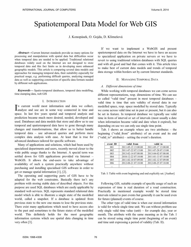
Abstract—Current Internet standards provide us many options for
processing and manipulation with spatial data but difficulties occur
when temporal data are needed to be applied. Traditional relational
databases widely used on the Internet are not designed to store
temporal data and this fact limits us in developing more enhanced
geographic models. This article is comparing several data models and
approaches for managing temporal data, their suitability especially for
practical usage, e.g. performing difficult queries, analyzing managed
data as well as supporting construction of specific data formats needed
by different web applications.
Keywords— Spatio-temporal databases, temporal data modelling,
time stamping data, web GIS
I. INTRODUCTION
N current world most information and data we collect,
analyze and use are in some way connected in time and
space. In last few years spatial and temporal analysis and
prediction became much more desired, needed, developed and
used. Databases and data models that store and allow us to use
temporal and spatiotemporal data have to gone through many
changes and transformations, that allow us to better handle
temporal data – use advanced queries and perform more
complex data analysis with ease. At least that is true for
advanced databases tailored for specific software.
Many of applications and solutions, which had been used by
specialized departments and users, recently moved closer to the
wide public usage thanks to the Internet. A special term was
settled down for GIS applications provided via Internet –
WebGIS. It allows the end-users to take advantage of
availability of such a system practically anywhere without
purchasing and installing specialised GIS software in order to
get or manage spatial information [1], [2].
The operating and supporting parts of GIS have to be
adapted for the web constraints. Basically there isn’t any
problem with storing stable data of described objects. For this
purpose are used SQL databases which are easily applicable by
standard web services. SQL represents standard relational data
model which is able to illustrate a single state of the modelled
world, called a snapshot. If a database is updated from
previous state to the new one means to lose the previous state.
There exist many applications which need to have access also
to the past and sometimes to the future states of the modelled
world. This definitely holds for the most geographic
information systems which use spatial data changing in time
very often [3].
If we want to implement a WebGIS and present
spatiotemporal data on the Internet we have to have an access
to specialized application on private servers or we have to
revert to using traditional relation databases with SQL queries
and with all good and bad that comes with it. This article tries
to make best of current data models and trends of temporal
data storage within borders set by current Internet standards.
II. MANAGING TEMPORAL DATA
A. Different dimensions of time
While working with temporal databases we can come across
different representations, resp. dimensions of time. We can see
so called “valid time” present in most temporal databases –
valid time is time that sets validity of stored data in our
modelled space, resp. space modelled by stored data. Typically
we come across valid time set in past or present, but it can also
be set in feature. In temporal database we typically use valid
time in form of interval or set of intervals (most usually a date
when information became valid and date when it expired), but
depending on use we can only use single time point.
Tab. I shows an example where are two attributes – the
beginning (“valid_from” attribute) of an event and its end
(“valid_to” attribute) – setting the event’s duration.
Following GIS, suitable example of specific usage of such an
expression of time is real duration of a road construction.
Practically in mentioned example would be stored time
intervals related to past events but generally it can be used even
for future (planned) events of course.
The other type of valid time is when our stored information
is valid for whole single time unit. We can without problem use
only single valid time value (unit) – for example day, year or
month. The attribute with the same meaning as in the Tab. I
can be stored using single time point (beginning of an event)
and time unit expressing a period of validity (Tab. II).
Spatiotemporal Data Model for Web GIS
J. Konopásek, O. Gojda, D. Klimešová
I
event_ID valid_from valid_to
001 2011-05-15 13:00:00 2011-05-17 13:00:00
002 2011-07-22 07:15:00 2011-07-28 07:15:00
003 2013-02-14 07:08:00 2013-04-02 07:08:00
004 2010-12-22 07:10:00 2011-01-13 07:10:00
005 2011-02-10 07:09:00 2011-02-12 07:09:00
006 2012-08-21 07:18:00 2012-08-25 07:18:00
... ... ...
Tab. I: Table with event beginning and end explicitly set. [Author]
INTERNATIONAL JOURNAL OF COMPUTERS Volume 8, 2014
ISSN: 1998-4308 76
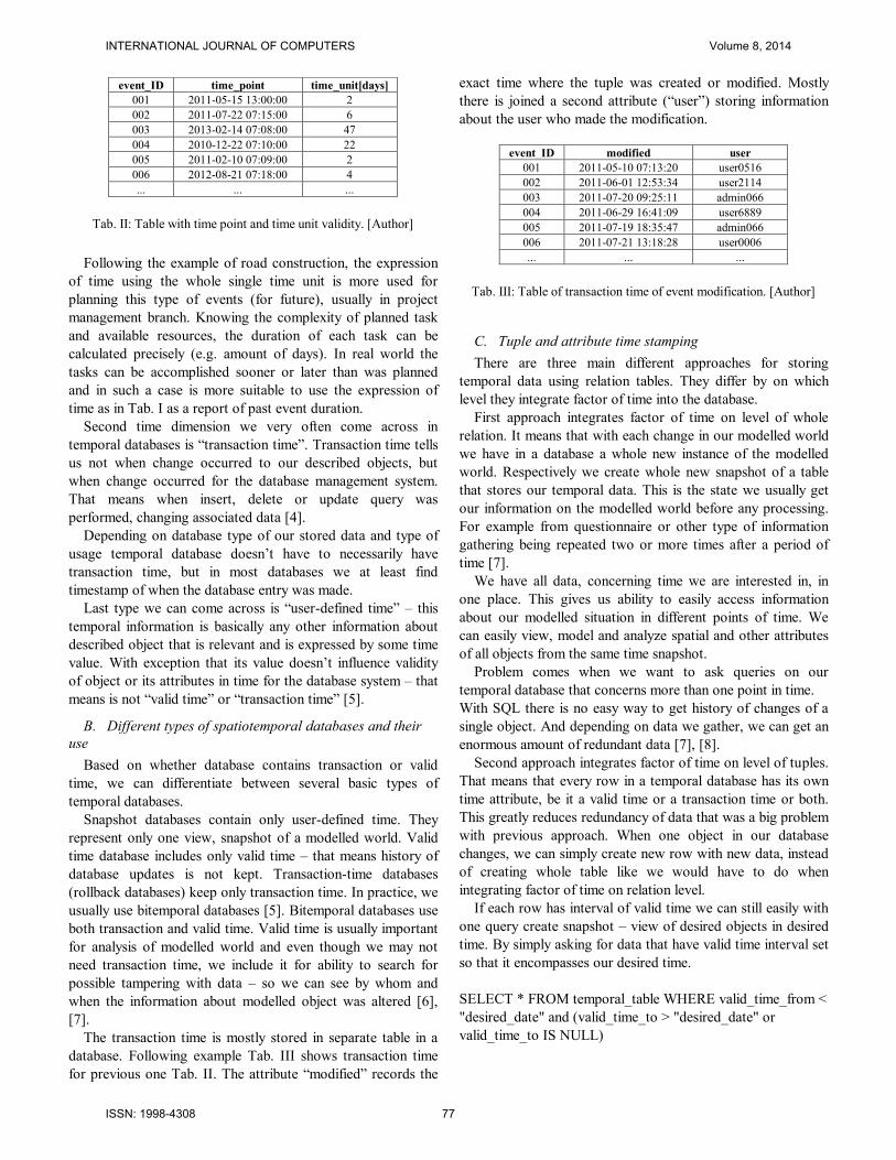
Following the example of road construction, the expression
of time using the whole single time unit is more used for
planning this type of events (for future), usually in project
management branch. Knowing the complexity of planned task
and available resources, the duration of each task can be
calculated precisely (e.g. amount of days). In real world the
tasks can be accomplished sooner or later than was planned
and in such a case is more suitable to use the expression of
time as in Tab. I as a report of past event duration.
Second time dimension we very often come across in
temporal databases is “transaction time”. Transaction time tells
us not when change occurred to our described objects, but
when change occurred for the database management system.
That means when insert, delete or update query was
performed, changing associated data [4].
Depending on database type of our stored data and type of
usage temporal database doesn’t have to necessarily have
transaction time, but in most databases we at least find
timestamp of when the database entry was made.
Last type we can come across is “user-defined time” – this
temporal information is basically any other information about
described object that is relevant and is expressed by some time
value. With exception that its value doesn’t influence validity
of object or its attributes in time for the database system – that
means is not “valid time” or “transaction time” [5].
B. Different types of spatiotemporal databases and their
use
Based on whether database contains transaction or valid
time, we can differentiate between several basic types of
temporal databases.
Snapshot databases contain only user-defined time. They
represent only one view, snapshot of a modelled world. Valid
time database includes only valid time – that means history of
database updates is not kept. Transaction-time databases
(rollback databases) keep only transaction time. In practice, we
usually use bitemporal databases [5]. Bitemporal databases use
both transaction and valid time. Valid time is usually important
for analysis of modelled world and even though we may not
need transaction time, we include it for ability to search for
possible tampering with data – so we can see by whom and
when the information about modelled object was altered [6],
[7].
The transaction time is mostly stored in separate table in a
database. Following example Tab. III shows transaction time
for previous one Tab. II. The attribute “modified” records the
exact time where the tuple was created or modified. Mostly
there is joined a second attribute (“user”) storing information
about the user who made the modification.
C. Tuple and attribute time stamping
There are three main different approaches for storing
temporal data using relation tables. They differ by on which
level they integrate factor of time into the database.
First approach integrates factor of time on level of whole
relation. It means that with each change in our modelled world
we have in a database a whole new instance of the modelled
world. Respectively we create whole new snapshot of a table
that stores our temporal data. This is the state we usually get
our information on the modelled world before any processing.
For example from questionnaire or other type of information
gathering being repeated two or more times after a period of
time [7].
We have all data, concerning time we are interested in, in
one place. This gives us ability to easily access information
about our modelled situation in different points of time. We
can easily view, model and analyze spatial and other attributes
of all objects from the same time snapshot.
Problem comes when we want to ask queries on our
temporal database that concerns more than one point in time.
With SQL there is no easy way to get history of changes of a
single object. And depending on data we gather, we can get an
enormous amount of redundant data [7], [8].
Second approach integrates factor of time on level of tuples.
That means that every row in a temporal database has its own
time attribute, be it a valid time or a transaction time or both.
This greatly reduces redundancy of data that was a big problem
with previous approach. When one object in our database
changes, we can simply create new row with new data, instead
of creating whole table like we would have to do when
integrating factor of time on relation level.
If each row has interval of valid time we can still easily with
one query create snapshot – view of desired objects in desired
time. By simply asking for data that have valid time interval set
so that it encompasses our desired time.
SELECT * FROM temporal_table WHERE valid_time_from <
"desired_date" and (valid_time_to > "desired_date" or
valid_time_to IS NULL)
event_ID time_point time_unit[days]
001 2011-05-15 13:00:00 2
002 2011-07-22 07:15:00 6
003 2013-02-14 07:08:00 47
004 2010-12-22 07:10:00 22
005 2011-02-10 07:09:00 2
006 2012-08-21 07:18:00 4
... ... ...
Tab. II: Table with time point and time unit validity. [Author]
event_ID modified user
001 2011-05-10 07:13:20 user0516
002 2011-06-01 12:53:34 user2114
003 2011-07-20 09:25:11 admin066
004 2011-06-29 16:41:09 user6889
005 2011-07-19 18:35:47 admin066
006 2011-07-21 13:18:28 user0006
... ... ...
Tab. III: Table of transaction time of event modification. [Author]
INTERNATIONAL JOURNAL OF COMPUTERS Volume 8, 2014
ISSN: 1998-4308 77
But dependent on a change of our data, it may still be a
problem to easily get data we want to. If we have information
on two different attributes of object in one table and one of
them changes we create new row so we can document the
change. That means that if we have those two attributes in one
relation we have created redundancy for the second attribute
that hasn’t changed [9].
And of course it becomes harder to get history of changes to
that attribute. If on the other hand we know that in every new
tuple/row our desired attribute of object has changed we can
easily get changes in time by selecting all the rows with the id
of said object.
We can remedy this in different ways. First usual approach is
to add new attributes dependent on groups of changing
attribute. These new attributes gain value when group of
attributes they are associated with changes. That helps us more
easily build queries, because we have information on what
attributes changed in each new tuple.
Tab. IV has two groups of attributes that always changes
together. First group is “Attribute 1”, second group is
“Attribute 2” and “Attribute 3”. Thanks to columns
documenting change, we can easily get years when every
attribute changed in one simple query.
Second variant to help with multiple attributes changing in
different time is to split them into different relations. This
eliminates redundancy completely, but it adds greatly to
complexity of select queries, because we have to join multiple
tables in single query even when we only want to gather
information about single object in single time [4].
It is clear that, if we are gathering data on objects that we
know will change all of its relevant attributes, or we know we
won’t be interested in working with history of attributes that
do not change every time – transforming temporal data into
form where changes are logged by time stamping at tuple level
is ideal way to manage those data.
In such a case it creates no or minimal redundancy and is
able to provide easy way to access temporal data, be it
information about history of an object or attributes of multiple
objects in time [7].
Third approach integrates factor of time at attribute level.
This means, we timestamp new attribute value of an object
with its own time parameter and store it as a part of the
attribute. This enables us to completely erase data redundancy,
because when attribute of an object changes, we only modify
existing attribute – add new information with timestamp. But
this approach doesn’t conform to relation table’s standard of
normalization.
For storing multiple values resp. multiple tuples of values as
one attribute we need to use tool that can work with nested
relational model and non-first normal form. Which means it is
not possible to normally use it in classic relation database –
some more advanced database management systems have the
ability to work with nested tables but the more simple
databases that are used for website use do not. Instead when
are making database that should be usable by web services and
we want to minimize redundancy, we have to use tuple based
approach and we create different relation for each attribute that
can change separately [7], [10].
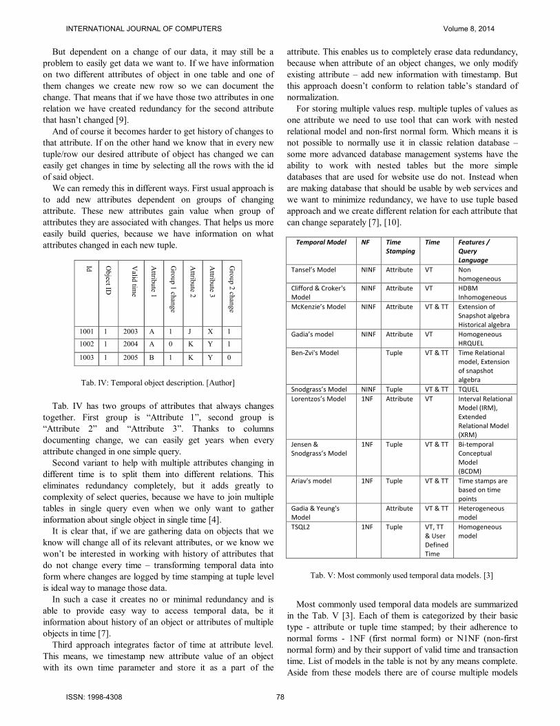
Most commonly used temporal data models are summarized
in the Tab. V [3]. Each of them is categorized by their basic
type - attribute or tuple time stamped; by their adherence to
normal forms - 1NF (first normal form) or N1NF (non-first
normal form) and by their support of valid time and transaction
time. List of models in the table is not by any means complete.
Aside from these models there are of course multiple models
Id
Object ID
Valid
time
Attrib
ute 1
Gro
up 1
chan
ge
Attrib
ute 2
Attrib
ute 3
Gro
up 2
chan
ge
1001 1 2003 A 1 J X 1
1002 1 2004 A 0 K Y 1
1003 1 2005 B 1 K Y 0
Tab. IV: Temporal object description. [Author]
Temporal Model NF Time Stamping
Time Features / Query Language
Tansel’s Model NINF Attribute VT Non homogeneous
Clifford & Croker's Model
NINF Attribute VT HDBM Inhomogeneous
McKenzie’s Model NINF Attribute VT & TT Extension of Snapshot algebra Historical algebra
Gadia’s model NINF Attribute VT Homogeneous HRQUEL
Ben-Zvi's Model Tuple VT & TT Time Relational model, Extension of snapshot algebra
Snodgrass’s Model NINF Tuple VT & TT TQUEL
Lorentzos’s Model 1NF Attribute VT Interval Relational Model (IRM), Extended Relational Model (XRM)
Jensen & Snodgrass’s Model
1NF Tuple VT & TT Bi-temporal Conceptual Model (BCDM)
Ariav's model 1NF Tuple VT & TT Time stamps are based on time points
Gadia & Yeung's Model
Attribute VT & TT Heterogeneous model
TSQL2 1NF Tuple VT, TT & User Defined Time
Homogeneous model
Tab. V: Most commonly used temporal data models. [3]
INTERNATIONAL JOURNAL OF COMPUTERS Volume 8, 2014
ISSN: 1998-4308 78
not scientifically described or models that are only slight
variations of the models we described in the table.
III. SPATIOTEMPORAL DATA MANAGEMENT
When working with spatiotemporal data we typically want
to do three types of things. Sort, manage and store those data
– for that we are typically using a Database Management
System. Next we want to analyze those data, refine them and
transform them to our specified need – for that we typically use
script or program with functions or ability to create algorithms
specialized for problem solution we want to perform.
And finally we want to view desired parts of data and of
course results to the analysis of those data as needed for end
user presentation.
For work with spatial data there are several programs that
do all of these things. One of the most used GIS software is
ArcGIS Desktop from ESRI [11].
A. ArcGIS database system
ArcGIS includes its own database system, analytic tools and
is able to visualize both vector and raster maps in many
different ways and prepare them for printing or is able to
export them into various formats. Whereas these programs are
ideal for analysis of classic GIS data, they usually somewhat
lack in ability to manage temporal data.
More complex ability to view temporal data was added to
ArcGIS Desktop only in the last version (ArcGIS 10) [12].
These complex programs also usually do not have ability to
generate complex customizable web based applications with
interactive views of the data. If they do allow some sort of web
publication it is most of the time dependent on specialized GIS
server – like for example ArcGIS Server (that is separate
application to Arcgis Desktop).
If we want to create a complex web application, that can be
connected to other databases and systems containing temporal
GIS data and we do not want to be dependent on specific GIS
server, we have to use separate tools we can modify to store
temporal GIS data, to enable easy with those data and to make
possible their visualization and publication on web site.
There are several approaches and applications that do so.
Many of them are end result of scientific research into temporal
databases, GIS data display etc. These applications of course
use different DBMS and different tools to create final website
view for end-user.
B. Dynamic web application
Most common relational database management system for
use with web sites and web site scripting languages are
MySQL and Oracle. They both conform to basic relational
standards and they both have many functions for working with
data, including several spatial functions including testing of
spatial relations [13].
To work with database we need server-side scripting
language that would allow us to create dynamic web
applications. Most popular such language is currently PHP. It
has extensive set of functions to communicate with MySQL,
Oracle or other relation database and there are many premade
web applications enabling us to work with databases and tables
through graphic interface (for example PHPMyAdmin) [14].
Scripting language enables us to create dynamic queries on
data in our database and generate desired output – be it parts
of data we want to export to ArcGIS for analysis or data we
want to display to end-user on the websites. For effective
interactive display of data at client side, there is basically only
one main language used to do so and that is java-script [15],
[16].
IV. CREATING WEB APPLICATION USING DATA FROM
TEMPORAL DATABASE
To create a website to view spatio-temporal data, we first
need to transform those data into data model that enables us to
easily update them and place queries that we are interested in.
The most basic approach is to create table that integrates factor
of time on tuple level and depending on how data change in
time allow some sort of redundancy or split the table into more
tables with groups of attributes that always change together.
As a part of our research we are currently trying different
data models while working with data in our case study. We
want to perform testing on speed of different data models. We
are also comparing their ability to accommodate queries and
ability to easily manage data for use with GIS application that
visualize those data for end user.
From preliminary research we compared various web based
GIS applications and we found out that most applications
process spatiotemporal data in form of one table with each row
time stamped with valid time. Most of those applications then
allow user to display objects on the basemap in selected
Fig. 1: Time slider in ArcGIS 10. [Author]
INTERNATIONAL JOURNAL OF COMPUTERS Volume 8, 2014
ISSN: 1998-4308 79
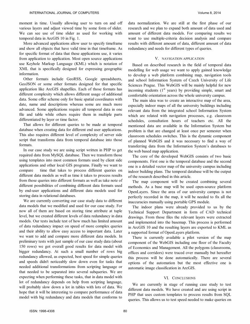
moment in time. Usually allowing user to turn on and off
various layers and adjust viewed time by some form of slider.
We can see use of time slider as used for working with
temporal data in ArcGIS 10 in Fig. 1.
More advanced applications allow user to specify timeframe
and show all objects that have valid time in that timeframe. As
for specific format of data that these applications use, it varies
from application to application. Most open source applications
use Keyhole Markup Language (KML) which is notation of
XML that is specifically designed for expressing geographic
information.
Other formats include GeoRSS, Google spreadsheets,
GeoJSON or some other formats designed for that specific
application like ArcGIS shapefiles. Each of those formats has
different complexity which allows different usage of additional
data. Some offer scheme only for basic spatial coordinates with
date, name and descriptions whereas some are much more
advanced. Some applications require all temporal data in one
file and table while others require them in multiple parts
differentiated by layer or time factor.
That allows for different queries to be made at temporal
database when creating data for different end user applications.
This also requires different level of complexity of server side
script that transforms data from temporal database into those
formats.
In our case study we are using script written in PHP to get
required data from MySQL database. Then we transform those
using templates into most common formats used by client side
applications and other local GIS programs. Finally we want to
compare time that takes to process different queries on
different data models as well as time it takes to process results
from those queries into different formats as well as take note of
different possibilities of combining different data formats used
by end-user applications and different data models used for
storing data in relational databases.
We are currently converting our case study data to different
data models that we modified and used for our case study. For
now all of them are based on storing time attribute at tuple
level, but we created different levels of data redundancy in data
models. Our tests include test of how much has limited amount
of data redundancy impact on speed of more complex queries
and their ability to allow easy access to important data. Later
we want to add and compare more different data models. In
preliminary tests with just sample of our case study data (about
150 rows) we got overall good results for data model with
bigger redundancy. At such a small number of rows big
redundancy allowed, as expected, best speed for simple queries
and speeds didn't noticeably slow down even for tasks that
needed additional transformations from scripting language or
that needed to be separated into several subqueries. We are
expecting when performing these tasks, that in data model with
lot of redundancy depends on help from scripting language,
will probably slow down a lot in tables with lots of data. We
hope that it will be interesting to compare performance of data
model with big redundancy and data models that conforms to
data normalization. We are still at the first phase of our
research and we plan to expand both amount of data used and
amount of different data models. For comparing results we
want to use multiple-criteria decision analysis and compare
results with different amount of data, different amount of data
redundancy and needs for different types of queries.
V. NAVIGATION APPLICATION
Based on described research in the field of temporal data
modelling for web usage we want to apply gained knowledge
to develop a web platform combining map, navigation tools
and school Information System of Czech University of Life
Sciences Prague. This WebGIS will be mainly helpful for new
incoming students (1st years) by providing simple, smart and
comfortable orientation across the whole university campus.
The main idea was to create an interactive map of the area,
especially indoor maps of all the university buildings including
relevant data from the integrated school Information System
which are related with navigation processes, e.g. classroom
schedules, consultation hours of teachers etc. All the
mentioned data are available in the Information System but
problem is that are changed at least once per semester when
classroom schedules switches. This is the dynamic component
of planned WebGIS and it was necessary to find a way of
transferring data from the Information System’s databases to
the web based map application.
The core of the developed WebGIS consists of two basic
components. First one is the temporal database and the second
one is a detailed vector map of the university campus including
indoor building plans. The temporal database will be the output
of the research described in this article.
The map component will be created combining several
methods. As a base map will be used open-source platform
OpenLayers. Since the area of our university campus is not
perfectly recorded in the map, it will be needed to fix all the
inaccuracies manually using portable GPS module.
The indoor plans were already provided to us by the
Technical Support Department in form of CAD technical
drawings. From those files the relevant layers were extracted
and implemented into the basemap. This process is performed
in ArcGIS 10 and the resulting layers are exported to KML as
a supported format of OpenLayers platform.
There is currently available a pilot version of the map
component of the WebGIS including one floor of the Faculty
of Economics and Management. All the polygons (classrooms,
offices and corridors) were traced over manually but hereafter
this process will be done automatically. There are several
options of the automation but the most effective one is
automatic image classification in ArcGIS.
VI. CONCLUSIONS
We are currently in stage of running case study to test
different data models. We have created and are using script in
PHP that uses custom templates to process results from SQL
queries. This allows us to test speed needed to make queries on
INTERNATIONAL JOURNAL OF COMPUTERS Volume 8, 2014
ISSN: 1998-4308 80
different temporal data models and create different formats of
temporal GIS data files. We would like our end result to be
methodology for choosing and implementing optimal data
model for web based temporal GIS based on specific user
requirements. Hereafter we plan to develop a WebGIS
following the designed methodology.
ACKNOWLEDGMENT
The paper was supported by the grant project of the Czech
University of Live Sciences: Methodology for Designing
Relational Database and Web Interface for Dynamic GIS, no.
20131027. This support is very gratefully acknowledged.
REFERENCES
[1] H. Kopáčková, H. Jonášová, I. Mikešová a J. Hejlová, „Gathering of
Requirements on WebGIS Development - the Example of Bikeway
Mapping Application,“ in Recent Researches in Circuits, Systems,
Communications and Computers: Proceedings of the 2nd European
Conference of Computer Science (ECCS'11), Stevens Point, WSEAS
Press, 2011, pp. 290-295.
[2] J. Komárková, P. Sedlák, M. Novák, A. Musilová a V. Slavíková,
„Problems in Usability of Web-Based GIS,“ in Proceedings of the
International Conference on Applied Computer Science (ACS), Athens,
WSEAS Press, 2010.
[3] A. Burney, N. Mahmood a K. Ahsan, „TempR-PDM: a conceptual
temporal relational model for managing patient data,“ in AIKED'10
Proceedings of the 9th WSEAS international conference on Artificial
intelligence, knowledge engineering and data bases, Stevens Point,
WSEAS Press, 2010, pp. 237-243.
[4] T. Ott and F. Swiaczny, Time-Integrative Geographic Information
Systems, Berlin: Springer Verlag, 2001.
[5] C. Combi, E. Karavnou-Papiliou and Y. Shahar, “Temporal Databases,”
in Temporal information systems in medicine, New York, Springer US,
2010, pp. 45-85.
[6] Y. Tang, X. Ye and N. Tang, Temporal Information Processing
Technology, New York: Springer Heidelberg, 2010.
[7] C. E. Atay, “A Comparison of Attribute and Tuple Time Stamped
Bitemporal Relational Data Models,” in Proceedings of the International
Conference on Applied Computer Science, Las Vegas, 2010.
[8] P. Revesz, “Temporal Databases,” in Introduction to Databases, London,
Springer-Verlag, 2010, pp. 67-79.
[9] J. R. R. Viqueira and N. A. Lorentzos, “SQL extension for spatio-
temporal data,” in The VLDB Journal, vol. 16(2), p. 179–200, 4 2007.
[10] I. A. Goralwalla, A. U. Tansel and M. T. Özsu, “Experimenting with
Temporal Relational Databases,” in Proceedings of the 1995 ACM
CIKM International Conference On Information And Knowledge
Management, New York, 1995.
[11] MyTopDozen.com, “MyTopDozen,” MyTopDozen.com, 2011. [Online].
Available:http://www.mytopdozen.com/Best_GIS_Software.html.
[Accessed 2013].
[12] Esri, “What's new for temporal data in ArcGIS 10”, Esri, 2010. [Online].
Available:http://help.arcgis.com/en%20/arcgisdesktop/10.0/help/index.ht
ml#//00qp00000018000000.htm. [Accessed 2013].
[13] solid IT, “DB-Engines Ranking of Relational DBMS,” solid IT, 2013.
[Online]. Available: http://db-engines.com/en/ranking/relational+dbms.
[Accessed 2013].
[14] E. Pultar, T. J. Cova, M. Yuan and M. F. Goodchild, “EDGIS: a dynamic
GIS based on space time points,” in International Journal of
Geographical Information Science, vol. 24:3, pp. 329-346, 3 2010.
[15] E. Pultar, M. Raubal, T. J. Cova and M. F. Goodchild, “Dynamic GIS
Case Studies: Wildfire Evacuation and Volunteered Geographic,” in
Transactions in GIS, vol. 13(s1), p. 85–104, 6 2009.
[16] X. Ye, Z. Peng and H. Guo, “Spatio-Temporal Data Model and Spatio-
Temporal Databases,” in Temporal Information Processing Technology
and Its Application, Berlin, Springer Berlin Heidelberg, 2010, pp. 91-
112.
INTERNATIONAL JOURNAL OF COMPUTERS Volume 8, 2014
ISSN: 1998-4308 81
![Real-time Spatiotemporal Stereo Matching Using …Real-time spatiotemporal stereo matching using the dual-cross-bilateral grid 5 Instead of image intensities, as in Chen et al.[10],](https://img.pdfslide.net/doc/110x75/5e61217b0775d940423ddb21/real-time-spatiotemporal-stereo-matching-using-real-time-spatiotemporal-stereo-matching.jpg)


![METHODOLOGY ARTICLE Open Access Home range plus: a space ... · Home range estimators commonly ignore time other than for time-interval windowing [6,40], while spatiotemporal and](https://img.pdfslide.net/doc/110x75/5f21ccc59d3ba03ef20eb3f4/methodology-article-open-access-home-range-plus-a-space-home-range-estimators.jpg)