Embed Size (px)
DESCRIPTION
Water Wheel Special Edition 2012 : Agricultural Water - Agro forestry, Agricultural Water - Commercial irrigation, Agricultural Water - Small holder irrigation, Agricultural Water - Rainwater harvesting
Citation preview

ISSN 0258-2244 Special Edition 2012
Special focus on WATER AND
AGRICULTURE


3The Water Wheel Special Edition 2012
4 RESEARCH AND DEVELOPMENTWRC – Making a difference in agricultural water management
6 WATER HISTORYKakamas – Oasis in the desert
10 WATER HISTORYRobertson – Valley of fruit and wine
14 WATER HISTORYVaalharts – A Garden in the Desert
20 COMMERCIAL IRRIGATIONWater savings: Persistence pays off at Vaalharts
24 FOOD SECURITYTowards productive water use and household food security in South Africa
26 IRRIGATION SCHEMESWater use efficiency – Irrigators take the lead in Lower Olifants
30 WATER USE IN AGRICULTUREImproved water use only a satellite away
34 PASTURE IRRIGATIONNew WRC guidelines helping dairy farmers to greener pastures
37 RAINWATER HARVESTINGWater harvesting and conservation – Training the trainers
40 IRRIGATION EFFICIENCYIrrigation water use efficiency – It is all about balance
THE WATER WHEEL is a two-monthly magazine on water and water research published by the South African Water Research Commission (WRC), a statutory organisation established in 1971 by Act of Parliament. Subscription is free. Material in this publication does not necessarily reflect the considered opinions of the mem-bers of the WRC, and may be copied with acknow ledgement of source.
Editorial offices: Water Research Commission, Private Bag X03, Gezina, 0031, Republic of South Africa. Tel (012) 330-0340. Fax (012) 331-2565. WRC Internet address: http://www.wrc.org.za Editor: Lani van Vuuren, E-mail: [email protected]; Editorial Secretary: Mmatsie Masekoa, E-mail: [email protected];Layout: Drinie van Rensburg, E-mail: [email protected]
Cover: This Special Edition celebrates
research into irrigation and agricultural
water management.
ISSN 0258-2244
Special focus on WATER AND
AGRICULTURE
CONTENTS

Research and development
Agriculture may no longer directly contribute significantly to the national gross domestic product
(GDP), but it still plays an indispensable role in the health and welfare of the nation, particularly in the rural sector. Forward linkages to processing industries and backward linkages to input suppliers boost agriculture’s contribution to the GDP to between 20% and 30%.
More importantly, in South Africa it is estimated that up to 35% of the eco-nomically active population are directly or indirectly dependent on agriculture. This consists mainly of small-, medium- and large-scale enterprises, which provide employment opportunities for formal and casual labour. An estimated 42,7% of the
revitalisation of irrigation schemes, parti-cularly in the former homelands is required for household and community level irriga-tion. Water for food production also needs to be boosted in home gardens in rural villages or towns and peri-urban areas.
The overall objectives of Commission-funded research projects are therefore to assist farmers to utilise scarce water resources efficiently, beneficially and sus-tainably to increase household food secu-rity and farming profitability, and thereby increase social and economic welfare. Key issues currently being addressed are the productivity of water use for crops and livestock, poverty reduction and wealth creation in rural areas as well as the pre-vention of resource degradation. These
WRC – Making a difference in agricultural water management
As the foremost funder of water-related agricultural research in South Africa the Water Research Commission (WRC) is playing an important role in ensuring the
sustainability of the country’s farmers, from household through to commercial scale.
population are rural survivalists with tra-ditional agrarian lifestyles. Estimates also show that close to 50% of the population are living below the poverty line of which 70% are in rural areas. It is particularly the lives of these rural poor that the WRC wishes to uplift through its agricultural and water research.
As a result of the realities of living in a semi-arid country, irrigation plays a cru-cial role in many a South African farming enterprise. The irrigated agriculture sector remains the country’s largest water user, and is therefore one of the main focus areas of WRC-funded research. Farmers are under increased pressure to boost produc-tion for a growing population while using less precious resources. At the same time,
Grae
me W
illiam
s/Afri
ca M
edia
Onlin
e
The Water Wheel Special Edition 20124

efforts are aligned with government aims to reduce poverty and ensure sustainable socio-economic growth and development.
Over the past nine years the WRC has made a strategic shift to achieve a balance between research projects in irrigated and rain-fed agriculture, agro-forestry and aquaculture; to promote farmer involve-ment in poor rural communities and through participatory action research; and to take research projects further toward practical application of results with tech-nology transfer projects.
Current agriculture and water-related projects include, among others, deter-mination of water use of irrigated crops with satellite imagery; improved water use efficiency through deficit irrigation of wine grapes; quantification of the water use of indigenous crops; modelling of the water use of selected pasture crops for livestock grazing management; and the evaluation of water use and nutritional productivity of food crops in the diet of rural poor people.
The WRC is also assessing the water quality of rainwater and groundwater for domestic use and livestock watering; seeking alternative treatment options for microbial-contaminated irrigation water to improve food safety; rehabilitating invaded catchments and measuring the water use of indigenous trees; empower-ing women through water use security and skills development to achieve household food security; and investigating indigenous coping strategies for drought adaptation with concomitant vulnerability analysis for drought impact assessment related to climate change.
WRC-funded research has moved beyond the realm of traditional contri-butions made by scientists in applied disciplines or focus areas of soils, crops, engineering, climatology, economics and sociology to include larger multidisciplinary and/or interdisciplinary research efforts.
Through its research, the Commission is demonstrating that although the quantity and quality of water resources available for agricultural use are limited, it need not be a constraint for economic development. The requirement is that water resources must be utilised productively and greater efforts with research and development must be made to increase productivity, growth and thereby the competitiveness of agriculture.
Current WRC agriculture and water research portfolio
• Increasing the productivity of rainwater and irrigation water for crop and livestock production• Uplifting rural economies through commercial food production• Quantifying the water footprint in food value chains• Eradicating hunger and reducing poverty• Improving nutrition and health• Generating alternative sources of renewable energy• Preventing soil and water degradation and pollution• Adapting farming systems to climate change
WRC-funded research is aimed at improving water use efficiency – and thereby productivity and competitiveness – of both commercial and emerging farmers in South Africa.
Lani
van V
uuren
The Water Wheel Special Edition 2012 5
Research and development
Water History
From mid-1895 to late 1896 a severe drought raged over large parts of South Africa.
At the same time rinderpest, a fatal cattle disease, swept through south-ern Africa. In the Transvaal alone, half of the farmers’ cattle herds were wiped out. Then the South African War broke out in 1899. Apart from killing thousands of people, mostly
civilians, the war finally crushed the Republics’ farming communities through Britain’s Scorched Earth Policy, which saw an estimated 30 000 farmsteads being destroyed in the Transvaal and the Orange Free State. Most of the herds in the Boer republics were decimated, with crops and implements destroyed.
These events brought thousands
of farmers to their knees, and many found themselves without income and on the brink of starvation. Those that did not become bywoners (labourers who provided their ser-vices in exchange for privileges such as housing and grazing) on other farms flocked to cities in search of work. The majority of these termed ‘poor whites’ or Armblankes were
Water History
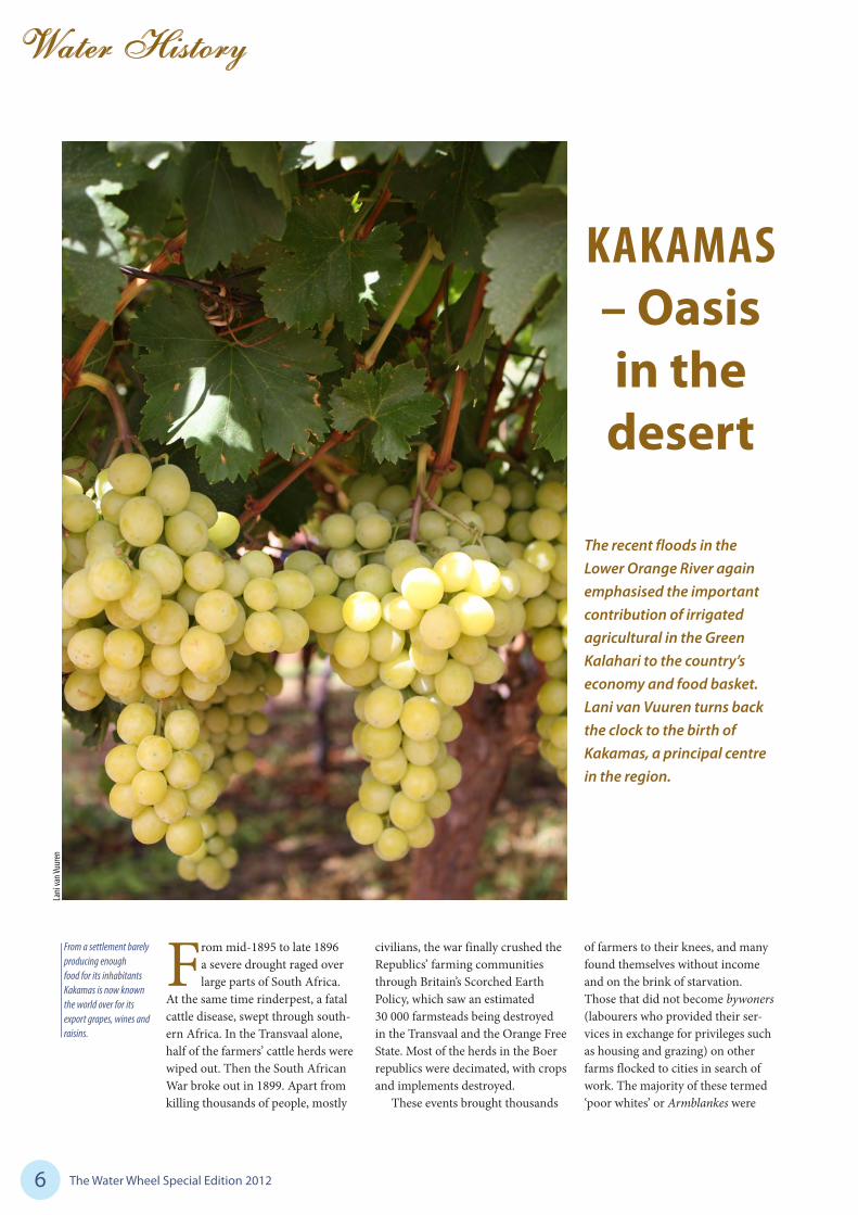
KAKAMAS – Oasis in the desert
The recent floods in the Lower Orange River again emphasised the important contribution of irrigated agricultural in the Green Kalahari to the country’s economy and food basket. Lani van Vuuren turns back the clock to the birth of Kakamas, a principal centre in the region.
6
From a settlement barely producing enough food for its inhabitants Kakamas is now known the world over for its export grapes, wines and raisins.
Lani
van V
uuren
The Water Wheel Special Edition 2012

Water History
Afrikaans-speaking and members of the Nederduitse Gereformeerde Kerk (Dutch Reformed Church).
Following repeated calls to the church to alleviate poverty among members of its congregation, the idea of establishing labour colonies was born. It was thought that these colonies, which would be established around irrigation schemes, would not only help clothe and feed poor families, but also enrich their spirit-ual lives and improve their education (one in ten poor whites were totally illiterate in those days).
In 1894, the church investigated several sites for the establishment of such a settlement and, in the end settled on an area on the banks of the Orange River. The area came highly recommended by Rev. Christiaan Hendrick Wilhelm Schröder who had established a mission station among the local Korana people at Olyvenhoutsdrift (now Upington) in 1871. Schröder, of German parentage and a carpenter by trade, had suc-cessfully constructed a water canal in Upington several years earlier. Upon completion in 1883, the canal was 32 km long.
THE START OF THE KAKAMAS SCHEME
In 1897, the Cape government granted the church two farms,
Soetap and Kakamas, on the left bank of the Orange River for the establishment of its irrigation settle-ment. Schröder would become the settlement’s first Superintendent. A canal had to be built to enable irrigation on the scheme. Govern-ment engineers estimated that such a canal would cost £29 000 to be constructed, however, Schröder
Water History
7
The Kakamas canals were initially earth furrows which were later improved and concreted by the Department of Water Affairs.
reckoned it would only cost £5 000 if done ‘the Boer way’.
Famed trader Japie Lutz, who had assisted Schröder in the construc-tion of the Upington canal, came to assist the reverend in the design of the canal (interestingly, he had no engineering qualifications) and work started on the left bank (or south) furrow on 4 July, 1898. On the Sun-day prior to the start of the project a special church service was held to pray for the success of the project and Schröder personally visited the tent of every prospective settler who had arrived to work on the scheme.
WATER AND THE DUTCH REFORMED CHURCH
Kakamas was not the only irrigation settlement established by the Dutch Reformed Church. In 1908 the church purchased six farms in the Rouxville
district along the Orange River in the Free State with the aim of establishing an irrigation settlement there. A weir was constructed on the north bank of the river close to Aliwal North along with a main canal of 9 km. This work was completed in 1912. The settlement, to be known as Goedemoed, was officially opened on 23 March, 1913.
Every settler received 3,5 ha with a total irrigable area of 513 ha. Similar to Kakamas the church retained ownership of the land, with rent of £10 a year pay-able. By 1922, there were 80 families settled at Goedemoed.
Lani
van V
uuren
The Water Wheel Special Edition 2012

8
Water History
More than a hundred years after their construction, the Kakamas canals still play a crucial role in agriculture in the Northern Cape.
to which spirit levels were attached, were used as instruments to deter-mine the levels of the canals.
By April 1899 the left bank furrow was completed to about the eleventh kilometre where the first erven were cut up for the 60 men who had worked the longest. Lots were drawn for choice of plot, each being 5 ha in extent. Livestock could be grazed on communal land. No work was undertaken during the South African War, but construc-tion resumed following the signing of the peace accord and, in 1908, the left bank furrow (35 km long), with extension to Marchand, was finally completed. This was followed by the completion of the 43 km-long right bank (north) furrow in 1912. For this purpose the church purchased 9 farms or portions of farms. The scheme was financed entirely by the church through collections at Sunday ser-vices across the country.
The canals feature exceptional dry piling of the stone along rocky slopes which can still be seen today. By dry piling instead of excavating through rock, the settlers were able to cut the overall costs of the canals considerably. FE Kanthack, who was later to become Director of Irrigation
school with 30 pupils was opened in a canvas tent.
Construction was not easy going. Most of the men were inexperienced and ill equipped for the hard physi-cal labour and the harsh conditions on site took its toll. Merely getting materials and equipment to Kakamas proved quite a challenge. The nearest railway ended at De Aar some 418 km away and all tools, dynamite, and others materials had to be trans-ported from there by wagon. Rifles,
The site for the intake was chosen at Neus, just upstream of the Neus Falls, where the river drops some 9 m. White labour only was used and labourers were paid three shillings a day and promised allotted pieces of irrigation land for their efforts. Food and clothing was supplied to them at cost price from a specially constructed warehouse. The first shops at Kakamas grew out of this warehouse (by 1945 there were four trading stores). On 18 July, the first
Remnants of the original water wheels can still be viewed at Kakamas. The wheels were used in lieu of pumps to transfer water to irrigate higher-lying areas. They have all been declared national monuments.
Lani
van V
uuren
Lani
van V
uuren
The Water Wheel Special Edition 2012

SOURCES
• Hopwood, T (1922) Kakamas Irrigation Settlement in The South African Irrigation Department Magazine, 1 (5), 239-243.
• Union of South Africa (1912) Report on Kakamas Labour Colony for period ending 30th of Septem-ber, 1911. Government Printer: Cape Town. Report No: UG 8-1912.
• Union of South Africa (1919) Preliminary report of the Kakamas Commission of Enquiry. Cape Town: Government Printers. Report No: UG 55-1919.
• Union of South Africa (1945) Report of the Commission of Enquiry Kakamas Labour Colony. Government Printer: Pretoria. Report No: UG 14-1945.
• Willcox, AR (1986) Great River, story of the Orange River. Winter-ton: Drakensberg Publications.
• Green Kalahari Tourism (www.greenkalahari.co.za).
9
(the forerunner to the Department of Water Affairs) was highly impressed with Lutz’s work when he visited the scheme in 1911. “The 6 000 yards of drystone walling, much of which is of very considerable height, is all of first class workmanship and besides being highly efficient there is a finish about Lutz’s work which is rarely to be found in work not carried out under direct professional control,” he said.
For the north bank furrow two tunnels were also required, the long-est being 192 m. From time to time the furrows were extended to bring more area under irrigation.
LIFE AT THE SETTLEMENT
Not just any person could come and live at Kakamas. Settlers
were carefully screened – they had to be men with families, had to prove they were poor, and had to be of ‘good conduct’ (no ‘squatters, vagrants or vagabonds’ allowed). Applications were submitted to the Superintendent at Kakamas
through their local church minister. By 1945 there were 574 families on the scheme, and the total (white) population was around 3 500. The main products grown were sultanas, wheat, peas, beans and lusern.
Each settler was allowed a lead-ing sluice consisting of a short pipe 150 mm in diameter with stopper, which they were allowed to open for eight to ten hours a week (in periods of low rainfall the allow-ance was reduced accordingly). The farmers themselves were responsible for cleaning the furrows. Each man was responsible for the maintenance of the length running along his plot, the common portions being maintained by a system of call-ing up labour. The plots remained the property of the church, and an annual rent of £10 was paid. If after the probationary period of five years the settler proved himself, he was allowed to stay on the plot.
A very strict code of conduct was followed with severe implications for those who violated the rules. Settlers were required to be neat and tidy, and all plots had to be kept clear of weeds. Fencing had to be kept in good repair, and pigs and poultry found wandering outside dedicated areas were summarily shot. The Christian observance of Sunday was
Water History
compulsory for adults and children, as was education. No dancing, swearing, filthy language, drunken-ness, or immorality was allowed and the sale or making of liquor was strictly prohibited. All new set-tlers had to undersign a document whereby they agreed to abide by these rules. Those who transgressed could be fined up to £5 or removed from the settlement.
One of the most endearing characters of Kakamas was Ouma Chrissie Viviers, who with her husband joined the labour settle-ment in 1904. In the absence of a hospital or clinic she served the community dutifully as a nurse for many decades. She had no formal training, but relied on her own Boer remedies and was a competent midwife. It is said that no distance was too far for her to travel, and not even the Orange River in flood could prevent her from reaching her patients. During the outbreak of Spanish Influenza in 1918, the Kakamas community was found to be far less affected than the rest of the region, thanks to Ouma Chris-sie’s traditional medicines. Not even the arrival of Dr Van Niekerk in 1927 stemmed the flow of patients to her door. She still saw patients up to her death in 1940.
A close-up of a water wheel.
Lani
van V
uuren
The Water Wheel Special Edition 2012
The Water Wheel Special Edition 201210
Water History
White farmers had settled most of the Breede River valley by the begin-ning of the 18th century, although large-scale development only took place following the cutting of passes through the mountains a century later. The valley was one of the first areas of South Africa where modern irrigation practices were applied – the earliest known irrigation works on the Breede River date back to the 1860s.
ROBERTSON IRRIGATION SCHEME
One of the oldest State-sup-ported irrigation schemes in
the country is situated at Robertson, in the Western Cape. From about
1860, the possibility of irrigating the rich soils along the north bank of the Breede River, reaching from the Vink River to the Kogmanskloof River was discussed among farmers and in Parliament. As far back as 1862, Civil Commissioner of the Robertson District, Mr Le Brun, requested State assistance to establish an irrigation scheme in this area.
Between 1865 and 1875 some minor attempts to use the river for irrigation were made with a certain degree of success. But it was not until 1896, backed by the Cape Irrigation Act, that concrete moves were made to establish irrigation in the area on a large scale. Between 1896 and 1897, at the request of the landowners, sur-veys were made by the Cape Public
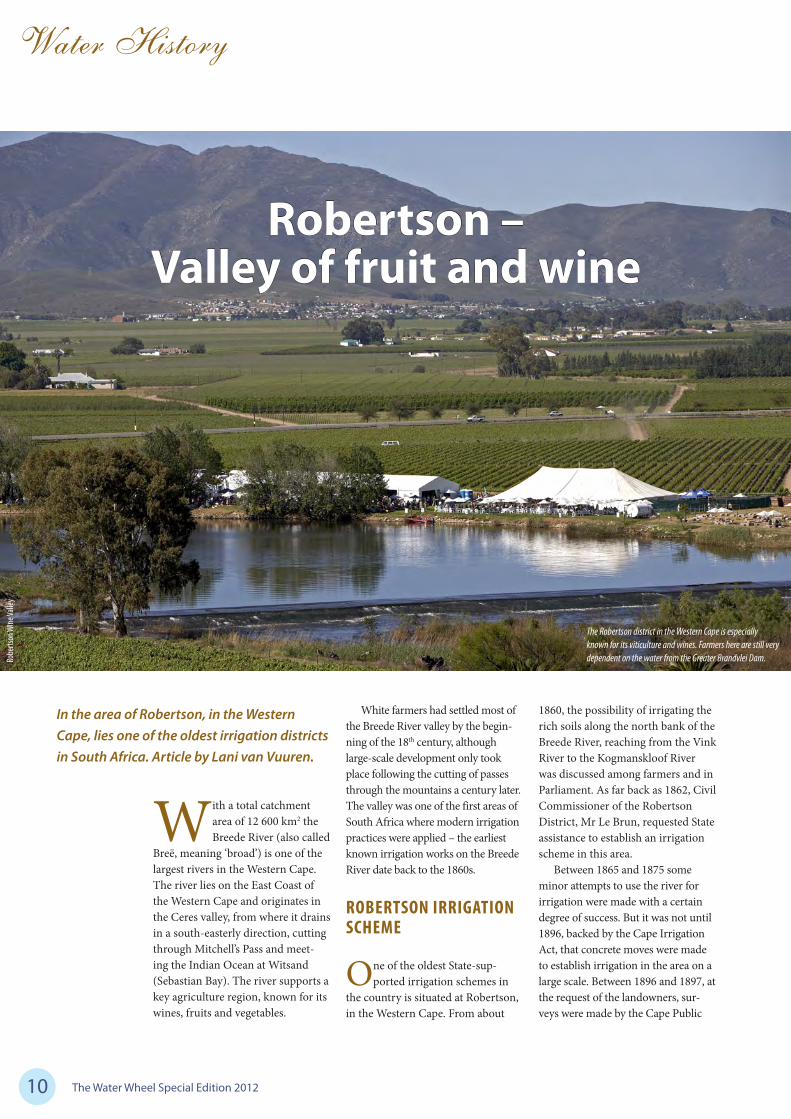
Robertson – Valley of fruit and wine
In the area of Robertson, in the Western Cape, lies one of the oldest irrigation districts in South Africa. Article by Lani van Vuuren.
The Robertson district in the Western Cape is especially known for its viticulture and wines. Farmers here are still very dependent on the water from the Greater Brandvlei Dam. Ro
berts
on W
ine Va
lley
With a total catchment area of 12 600 km2 the Breede River (also called
Breë, meaning ‘broad’) is one of the largest rivers in the Western Cape. The river lies on the East Coast of the Western Cape and originates in the Ceres valley, from where it drains in a south-easterly direction, cutting through Mitchell’s Pass and meet-ing the Indian Ocean at Witsand (Sebastian Bay). The river supports a key agriculture region, known for its wines, fruits and vegetables.

The Water Wheel Special Edition 2012 11
Water History
Irrigation Board to undertake the scheme on their behalf. Parliament approved a loan of £23 500 (later increased to £33 000). The period for repayment was fixed at 40 years at an interest rate of three-and-a-half percent. Tenders were called for the work, but the Irrigation Department disapproved of all the submissions received and decided to construct the work on behalf of the Irrigation Board.
Construction of the scheme started in February 1900. Work comprised a diversion weir across the Breede River, about 8 km outside the town of Robertson. Government engineer TE Scaife was appointed Resident Engineer and work was car-ried out through small contracts and by day labour. The weir was described to be of ‘singularly bold design’, consisting as it did of a thin concrete wall some 2 m high and up to 0,9 m thick, flanked on both sides by steep slopes of loose rubble without mortar of any kind or other means of secur-ing cohesion. In addition, the base of the wall was not founded on rock, but on gravel about 2,4 m below the riverbed. It was 366 m long.
Construction was interrupted by the South African War and further delayed by the river being in flood. The scheme was not completed until 1904. In 1902, considerable damage was caused to the unfinished weir by high floods in tributaries of the main river where they cross the line of the canal. Surprisingly, this unu-sual structure withstood the test of time and floods. In 1923, Cape Town Circle Engineer W Farrant notes: “A very small amount of maintenance has been necessary during the last 20 years. It is only recently that some of the loose stone on the downstream slope has been washed out. Floods have risen over 9 feet [2,7 m] in depth on the crest of the weir.”
At the time the main crops pro-duced through irrigation from the scheme were grain, lucerne, wine and fruit.
By 1918, several irrigation boards had been proclaimed in addition to
Robertson. These included Zand-drift Irrigation Board (proclaimed in 1909), Le Chasseur and Goree Irrigation Board (1910), and Angora Irrigation Board (1917). By the end of the second decade of the 1900s several small weirs and canal schemes had been constructed to abstract water from the river at vari-ous points.
Farmers frequently found themselves without adequate water supplies, especially during the dry summer months (the region being dependent on winter rainfall). As far back as 1906 proposals were put forward for the construction of a storage dam at Gerberspoort near Wolseley, together with a high-level canal known as the Ashton Scheme. The scheme appears in various reports of the Cape Irrigation
Department until 1909, after which it seems to have fallen off the radar, mainly due to the difficulty in obtaining suitable foundations for a dam.
BRANDVLEI DAM
Following the establishment of the Union Irrigation Department in
1912, the development of water stor-age works in the Breede River valley again came to the fore. At this time about 7 710 ha of land lie under irri-gation in the valley. The department investigated several possible loca-tions along the river and eventually settled for a site situated about 10 km from the town of Worcester.
Here the surveyors found a natu-ral vlei (Brandvlei, meaning ‘burning
Top left: A dry Brandvlei Dam, also known as Lake Marais, during the drought of the 1930s.
Bottom left: Brandvlei Dam in 1955, prior to its augmentation.
DWA/
eWISA
DWA/
eWISA

The Water Wheel Special Edition 201212
Water History
wetland’) about 10 km in extent and fed by natural hot springs. The vlei was located close to the Breede River. At times of flood the Breede River backed up into Brandvlei through a gap 550 m in width between the hills flanking the river and formed a large expanse of water. As the river fell, this water receded back through the gap. The department’s engineers conceived the idea whereby a dam would be placed across this gap, and filling the reservoir thus formed from the Holsloot River, a tributary of the Breede.
The original design was for a concrete dam, however, test bor-ings revealed layers of sandy clay, sand and gravel, rock bottom being reached only at a depth of about 25 m, in the centre of the gap. Since this would make the cost of a con-crete dam prohibitive, the design-ers instead opted for an earthen embankment without a core wall. A puddle clay apron was to be con-structed on the upstream face. This apron extended to a width of 34 m opposite the highest part of the embankment, decreasing in width as
it approached the flanks. The origi-nal storage capacity of the dam was 45,8 million m3 and the area of water surface extended 15,5 km2 (at full supply level).
The Breede River Conservation Board was proclaimed in 1918 to take ownership of the project, and Edmund Burrows was appointed Resident Engineer. Work started in March 1920 under contract with Messrs JW Wilson and Company from Johannesburg. The embank-ment was pitched on the down-stream side as well as upstream to protect it from Breede River floods. In addition, five (hand-operated) regulating sluices, 1,8 m by 0,9 m, with steel gates were installed for the dual purpose of discharging the required water into the river for the numerous irrigation works down-stream, and of allowing through floodwater. The total length of the dam wall was 990 m and it had a maximum height of 7 m.
Since the dam would submerge the old road from Worcester to Villiersdorp, it had to be diverted to pass along the crest of the dam, which was built wide enough to accommodate a 6 m roadway. Along the upstream edge of the crest, a metre high masonry wall was built to protect the surface of the roadway and the travelling public from the north-westerly gales which prevailed during winter months. These winds caused a great deal of inconvenience to the construction team.
Halfway through the project severe floods caused serious damage to the works, however, the work was eventually completed in 1922. The total amount of material in the struc-ture of the dam, including apron, pitching and masonry amounted to 172 025 m3, and the total cost of the project (including roads) was £47 570.
GREATER BRANDVLEI DAM
Like many other dams in South Africa, Brandvlei Dam is
Above: The Breede River is one of the larger rivers in the Western Cape.
Right: Completed in 1981, Greater Brandvlei Dam is still a major water supplier to agricultural activities in the Robertson area.
DWA/
eWISA

The Water Wheel Special Edition 2012 13
Water History
SOURCES• Anon (1921) ‘Brandvlei (Worcester)
conservation dam’ in South African Irrigation Department Magazine 1(1), p14
• Anon (1978) ‘Greater Brandvlei Dam’ in The Civil Engineer in South Africa 20(2), p46
• Burrows E (1923) ‘Brandvlei Dam, Worcester’ in South African Irriga-tion Department Magazine 2(1), p33-34
• Department of Water Affairs (1969) Notes on Some of the More Impor-tant Irrigation and Multi-purpose Schemes Built and/or Controlled by the Department of Water Affairs. DWA: Pretoria
• Republic of South Africa (1972) Secretary for Water Affairs report on the proposed Greater Brandvlei Dam Government Water Scheme. Government Printer: Pretoria. Report No: WP J-‘72
• Thanks to eWISA and Robertson Wine Valley for photographs
plagued by sedimentation, and in 1950 it became necessary to increase the capacity of the dam to 84 mil-lion m3. By 1972, this capacity had diminished to 76 million m3. During that time the Department of Water Affairs began investigations into suitable off-channel storage sites for a dam to control the runoff of the Breede River. At first it appeared that a dam at the northern exit of the Slanghoek Valley would be most suitable.
The department’s engineers had reservations about constructing a major high dam at Brandvlei, mainly on account of the difficulties and high cost expected in the sealing of the pervious foundations at the sight. However, a technology had been developed overseas involving the excavation of a deep and nar-row cut-off trench and then filling it with impervious slurry material. Engineers were confident that the method could be replicated success-fully at the Brandvlei site.
So, instead the Brandvlei- Kwaggaskloof basin was selected as the site of the new main storage unit in place of the Slanghoek Val-ley. The project consisted of raising Brandvlei Dam together with the corresponding raising of the adja-cent Kwaggaskloof Dam, which was under construction at the time. Sev-eral embankments were also built between some of the surrounding
hills. These two storage units then became an integrated off-channel storage unit. The original storage capacity of the combined rolled earthfill dam, completed in 1981, was 460 million m3. Today, the Greater Brandvlei Dam as it is known is still a major water supplier to agricultural activities in the area, specifically the wine farms around Robertson.
Above and left: In the 1980s the Greater Brandvlei Dam was created by the concurrent raising of the Brandvlei and adjacent Kwaggaskloof dams.
DWA/
eWISA
DWA/
eWISA
The Water Wheel Special Edition 2012

The Water Wheel Special Edition 201214
Water History
VAALHARTS – A Garden in the Desert
Nearly 80 years after its construction, Vaalharts remains the largest irrigation scheme in South Africa. Lani van Vuuren explores the history of this scheme which dates back at least 130 years.
The Water Wheel Special Edition 2012 15
Water History
Situated at the confluence of the Harts and Vaal rivers on the border between North
West and the Northern Cape, the Vaalharts irrigation scheme was first suggested by surveyor-general Fran-cis HS Orpen. He surveyed the area, which then formed part of Griqua-land-West after it was annexed by the British in 1871 for the establish-ment of settler farms.
Orpen found that the Vaal River bed was higher than the Harts River valley floor, making irrigation through the use of gravity-fed canals possible. In his report dated 22 December 1875 he wrote: “It is pos-sible, by taking out the water of the Vaal River near Fourteen Streams, to irrigate about half a million of acres in the Harts River Valley.”
The Griqualand-West war broke out before Orpen’s idea could be investigated further. In 1882, states-man John X Merriman proposed in parliament that a committee should be appointed to deal with irrigation matters, among others the proposed irrigation works at the Vaal and Harts rivers. The proposal was based on a report by Cape hydraulic engi-neer John Gamble. Merriman argued that the Vaalharts irrigation works would turn the ‘desert into a garden.’ Unfortunately the lack of funds pre-vented anything further to be done on the scheme.
RHODES PUSHES THE VAALHARTS SCHEME
Cecil John Rhodes advocated strongly for the proposed
Vaalharts scheme (then known as the Harts River Valley Irrigation Scheme), possibly because of its proxi mity to the rich Kimberley dia-mond mines. In 1886, he had already carried a motion to get some land between the Harts and Vaal rivers for the purposes of irrigation. Govern-ment granted him the land, however, he was unable to raise the money to implement the irrigation works.
Interestingly, it was Rhodes who first suggested that the land be made
available to poor white farmers who had lost every thing due to an outbreak of Rinderpest. He argued that the poor whites refused to work in the mines and would rather farm.
At that time the State was not prepared to pay for an irrigation scheme of that magnitude, however, it was decided that Crown Lands between the Harts and Vaal rivers would be granted to any company or individual prepared to implement such an irrigation scheme (at a cost not exceeding £130 000).
Unfortunately, no-one took up this offer. This, despite the fact that some Tswana-speaking and Korana communities had already been displaced in the locality of the proposed irrigation scheme to make room for white settlers. Rhodes even persuaded the government to carry out the works when he was Prime Minister, to no avail. The govern-ment’s argument was that other parts of the country also needed irrigation works.
In 1898, further efforts were launched to get the Vaalharts scheme off the ground when engineer HC Litchfield was appointed to investi-gate the possibility of an irrigation scheme in the Harts River valley. The Anglo-Boer War put a stop to inves-tigations a year later.
After the war, the Directors of Irrigation of the Cape and Transvaal (J Gordon and W Hurley) attempted to revive the Litchfield report. Each of them wrote a report recommend-ing the construction of a dam in the Vaal River. Again, there were no funds available.
The Vaalharts scheme was further put on the backburner by J Kanthack, the first Director of the Irrigation Department established after the Union of South Africa in 1910. His argument was that the area in the Harts River valley to be irrigated was too widespread. He thought that the limited resources of the govern-ment should rather be devoted to the encouragement of a large number of smaller schemes throughout the country.
THE PLAN IS REVIVED
The Vaalharts irrigation scheme gained new impetus following
the first World War as it became government policy to grant land to soldiers returning from the war. The proposed scheme was studied inten-sively by the Irrigation Department for the first time in 1925. A large number of holes were drilled to test the depth of the soil. During 1926/7 planning of the project started and further precise measurements were made from Border station to Taung. Aerial surveys were also undertaken by the South African Air Force.
In 1933, a decision was made to go ahead with the Vaalharts irriga-tion scheme (along with other large-scale public works) to relieve poverty
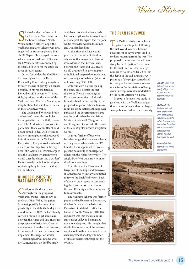
Top left: Gangs of ten to twenty men worked mostly with pick and shovel to construct the infrastructure for Vaalharts.
Middle left: The Vaalharts weir and main canal in 1946. Three hand-operated radial sluice gates of 3 m by 2,7 m make up the inlet sluices. These flow into a three-barrelled aquaduct, which controls the water flowing into the canal.
Bottom left: The Vaalharts weir during construction.
Vaalh
arts
Wat
erDW
A/eW
ISADW
A

The Water Wheel Special Edition 201216
Water History
among the white population, which had reached critical levels due to drought and the economic effects of the Great Depression. Originally, the plan was to construct a dam on the Vaal River at Christiana to provide water for the scheme. How-ever, following negotiations with the Rand Water Board (who desper-ately needed to augment its water resources for a growing Johannes-burg) the decision was made to construct the Vaal Dam at the con-fluence of the Wilge and Vaal rivers near Vereeniging. The Rand Water Board agreed to pay a portion of the cost to construct the dam. Water would flow from the Vaal Dam to a diversion weir 57 km downstream and then through the main canals to the scheme.
CONSTRUCTION OF THE SCHEME
In December 1933, construction teams started clearing land on the
farm Andalusia, near Border Station, to make way for offices, accommo-dation and storage facilities. It was first thought that Warrenton would serve as the headquarters of the scheme, but when the town council refused, the project team had to find an alternative venue.
In 1934, work started con-currently on the Vaal Dam, the Vaalharts weir (then known as Knoppiesfontein Dam) and the main canal. It was government policy to
only employ white labour. Labourers had to be unmarried (although mar-ried men were later also employed), between the ages of 18 and 45 and medically fit. Recruitment was done by the Department of Labour. Due to the ‘lack of white labour’ experienced later on in the project,
coloured and black workers were also employed on sections requiring only ‘unskilled’ labour.
The pay for white labourers was two shillings per day, with a bonus of one shilling 6d per day worked. These bonuses were paid into a Post Office Savings Bank and work-ers were only allowed to draw the money once they had completed their work. Money could be paid to dependents via a stop order. In the case of coloured labourers the greater of a man’s wages was sent by cheque to his dependents and only a small part was paid out to the man himself for pocket money.
For all jobs of a routine nature where the output could be accurately measured, payment was made on a piece-work basis. A gang of 10 to 20 men worked as a unit and at the end of the month their output was measured up and its value worked
Right: A concrete barrage-type structure, the Vaalharts weir has a height of 11 m and is 750 m long.
Below: In 1967, the Vaalharts weir was raised by 1,2 m to increase its capacity to 48,7 million m3.
Dana
Grob
ler
Vaalh
arts
Wat
er

The Water Wheel Special Edition 2012 17
Water History
out. The total value of the job was then divided up among the members of the gang in proportion to the number of Mondays each one had worked during the month. If the members of a gang found that any particular member was not pulling his weight, they could throw him out and invite someone else to join their gang.
LIFE ON THE SCHEME
Labourers were not entitled to have their families with them on
the works, but were accommodated in camps composed of a large num-ber of wood and iron bunkhouses, each containing four double-deck bunks (dubbed ‘hoenderstellasies’ or ‘chicken coops’). The more skilled workers and office staff were allowed to have their wives and families with them on the works and were
provided with houses at a reasonable rental.
Interestingly, Vaalharts was one of the first schemes on which electric light was provided for the staff. In the early stages the power station closed down at 10 pm except when there was a special function on. Later, power was available through-out the night.
As the works were spread out over a linear distance of 80 km the job was divided into sections, each in charge of a section engineer, and all under the control of the resident engineer at the headquarters of the scheme. Each section had its own camp, number one being at the weir, near Fourteen Streams Sta-tion, section two being near War-renton and section three next to the Headquarters Office near Border Station (this was later moved about a kilometre up the line and renamed
Jan Kempdorp Station). Section four was started later near Pokwani – this job included the construction of two tunnels.
All meals were free, and large mess halls and kitchens were built and staffed. Contracts were given out for the supply of meat, vegetables and milk daily in large quantities. A dry-goods canteen was also supplied at each camp. Goods here were not sold for cash, but rather coupons and were generally cheaper than in town.
Recreation facilities were also provided, among others a large recreation hall which could house 600 people. This had a stage and two small dressing rooms for stag-ing concerts and plays. The hall was also provided with a 35-mm cin-ematograph projector and films were shown twice a week. Rugby fields, tennis courts, a gold course and swimming pool were also provided.
The works also had a small church, a school and a number of field hospitals. The latter could
Top right: The post office and staff houses at Andalusia. The headquarters of the Vaalharts irrigation scheme later became a town on its own and in 1953 it was renamed Jan Kempdorp, after Genl Jan Kemp, Minister of Agriculture.
Bottom right: Mechnical and manual labour were employed at Vaalharts.
DWA
DWA

The Water Wheel Special Edition 201218
Water History
handle the ordinary run of medi-cines and provide first aid treatment, however, serious cases had to be sent to Kimberley. When there was an outbreak of epidemics (such as diph-theria or typhoid) mass immunisa-tion was undertaken.
MAN AND MACHINE
At Vaalharts both mechanical and manual labour were used.
Workers were transported to site by truck where each one got an area of 3 m by 3 m to dig out. Digging was done mainly by pick and shovel. Workers used 6 kg hammers used to break the rock, which was then placed in bags and hauled out of the steep sidewalls.
In really rocky areas it could take months to reach canal depth. The area known as the ‘blue canal’ was notoriously difficult to penetrate. Once one team had completed the digging another took over to cast the concrete lining.
The weir, a concrete barrage-type structure, has a height of 11 m and is 750 m long. It was designed to accommodate a flow of 10 000 cusecs (283,2 m3/s), with water 4 m deep flowing over the crest. Three sluice gates of 8 m by 6 m were built into the weir. In 1967, the weir was raised by 1,2 m to increase the storage capacity to 48,7 million m3.
Three hand-operated radial sluice gates of 3 m by 2,7 m make up the inlet sluices. These flow into a three-barrelled aquaduct, which controls the water flowing into the canal. Vaalharts comprises two main canals – A North Canal and a West Canal. By 1936 the first 40 km of the canals were completed and water first flowed into the canals on 15 December.
Work on the feeder and distribu-tion canals started in 1937. However, due to the outbreak of the Second World War these were only com-pleted by 1946. The main canal, feeder and distribution canals total more than 800 km. Later 300 km of drainage canals were also con-structed. All the canals are lined with concrete. To reduce pressure on the Vaal Dam, the Bloemhof Dam was constructed in the 1970s to feed the Vaalharts weir.
THE FIRST FARMERS
By 1938, the first 80 lots were ready for occupation. Applicants
were selected by a special commit-tee. Healthy persons under the age of 50 with dependent children were selected above unmarried applicants. Bona fide farmers, who lost farms due to circumstances ‘beyond their control’ were also preferred. Jobless-ness did not disadvantage applicants but could not be provided as the only reason why they should be allotted a piece of ground.
Once an applicant had been selected he had to go to the offices of the Department of Lands at Anda-lusia where he randomly chose a plot by picking a piece of paper out of a box containing the numbers of all the available plots. By 1940 there were 304 settlers on the scheme.
Basic housing was provided. Probationary lessees received livestock and production materials, for example a team of mules, dairy cows, a wagon, harnesses, a plough, harrow, small tools, seed and fertiliser. In exchange the lessee had to give the state a percentage
of his harvest for the first four years. After four years the lessee’s probation was over and he had the choice to purchase his lot.
Lessees did not pay for their water quota and were provide with a social grant for the first 18 months, the amount depending on their marriage status and number of children. Initially, they were not allowed to hire labour and everyone had to pitch in, even the children.
Due to the nature of the soil, a decision was made to establish an agricultural research station at Vaalharts in 1935. These early researchers knew just as little about which crops would be most suit-able as the new farmers and farm-ing really was by trial and error. In the early years, farmers mostly grew lucerne, ground nuts, pota-toes, grains and vegetables. Today, farmers also grow pecan nuts, cot-ton, olives, citrus, apricots, grapes, watermelon and peaches.
Wind was a considerable chal-lenge and an early solution was to plant long rows of poplar trees along the hedges of fields. At one stage, Vaalharts had one of the longest hedgerows of poplars in the world. Today, few of these original poplar hedges remain.
The Vaalharts Water User Asso-ciation took over the government scheme in 2003. It remains the largest irrigation scheme in the country, with a scheduled area of 29 181 ha.
SOURCES
• Hydropolitical History of South Africa’s International River Basins (WRC Report No: 1220/1/04)
• Living and working at Vaal Hartz, article in Water, House Journal of the Department of Water Affairs, August 1986
• Vaalharts by Hans Bornman• Thanks to DWA, Vaalharts
Water and eWISA for photographs
Almost all sluice gates at Vaalharts are still manually operated.

Contact Details
Name: .............................................................................................................................
Company: .......................................................................................................................
Designation: ...................................................................................................................
Postal Address: ...............................................................................................................
........................................................................................................................................
Tel: .................................................................................................................................
Fax: ................................................................................................................................
E-mail: ............................................................................................................................
What would your like to read more about in the Water Wheel? ....................................
........................................................................................................................................
........................................................................................................................................
Would you be willing to pay for the Water Wheel? .......................................................
The Water Wheel Tel: +27 (0) 12 330-0340 Fax: +27 (0) 12 331-2565 E-mail: [email protected] / www.wrc.org.za Physical address: Marumati Building, C/o Frederika & 18th Ave, Rietfontein, Pretoria Postal address: Private Bag X03, Gezina, 0031
ISSN 0258-2244
May/June 2011 Volume 10 No 3
Experts score bulk water a D
ISSN 0258-2244
July/August 2011 Volume 10 No 4
Elephants and water - An eternal
bond
Subscription Request Renewal
Address change
19 ad p 47.indd 1 2011/11/01 10:28:14 AM

The Water Wheel Special Edition 201220
Commercial irrigation
Productive water usage in irrigated agriculture remains a critical issue. While irrigation
accounts for 25% to 90% (depending on the crop) of agricultural produc-tion in South Africa, it uses about 60% of the country’s surface water. It is well known, however, that relatively large volumes of water are required to produce raw material for beneficia-tion in the food value chain. With competition for water growing from other users such as industry and mining, farmers are under increased pressure to improve water-use effi-ciency while still contributing to the country’s food market demands.
Water for agriculture is trans-ported over long distances by means of rivers, canals, on-farm furrows
and irrigation fields. On average, around 30% to 40% of water sup-plied to irrigation farms is lost in conveyance structures due to evapo-ration, spillage, leakage and incorrect water management with river and canal distribution. Older systems can record periodic losses of up to 70%. This means that, in most cases, sig-nificant water savings through better water loss control are possible.
VAALHARTS WATER
Situated at the confluence of the Harts and Vaal rivers on the
border between North West and the Northern Cape, Vaalharts irri-gation scheme was established by the government during the Great Depression years of the 1930s to curb poverty and unemployment, and remains the largest in the coun-try. The Vaalharts Water Association (Vaalharts Water) took over the water management of the govern-ment water scheme in 2003.
Water for this scheme is sourced from the Vaalharts Weir which, in turn, is fed by water from the
Bloemhof Dam on the Vaal River. Over 90% of the water supplied by Vaalharts Water is for agricultural use, with a small percentage being supplied to towns in the area.
From the weir the water is diverted into two main canals which divide into smaller canals to bring water to consumers. Apart from Vaalharts, the water user association also serves three other areas, each with its own water quota, namely Barkly West; Spitskop and Taung. There are about 1 873 abstraction points in the system.
Water savings: Persistence pays off at Vaalharts
With dedication, commitment and assistance from the Water Research Commission (WRC)’s Water Administration System (WAS), farmers at Vaalharts are proving that commercial irrigators can save water while feeding the nation. Lani van Vuuren visited the scheme.
Constructed in the 1930s, the Vaalharts Weir has a capacity of 48,7 million m3 and supplies the entire constituency of the Vaalharts Water User Association.
Lani
van V
uuren

The Water Wheel Special Edition 2012 21
Commercial irrigation
The largest served area is Vaal-harts itself, which has a scheduled area of 29 181 ha. A total of 1 120 km of main canal, feeder, community and drainage canals criss-cross this area, delivering water to hundreds of commercial and emerging farmers according to a set allocation. Farmers grow mostly cash crops, including groundnuts, wheat and lucerne. A small number of farmers also grow pecan nuts, citrus and grapes for wine production. All major forms of irriga-tion are used, including flood irriga-tion, sprinkler and micro irrigation.
Like many irrigation schemes in South Africa, Vaalharts works on the demand system, i.e. farmers only receive water once they order it. Farmers order water from Vaalharts Water through a ‘segman’ (spokes-person). This system is quite unique in South Africa. There are 240 such ‘segsmanne’ or spokespeople at Vaalharts.
THE WAS PROGRAM
WAS is a uniquely South Afri-can water administration
system aimed at increasing the pro-ductivity of water use in irrigated agriculture. Developed by Dr Nico Benadé with funding mainly from the WRC, WAS essentially provides irrigation schemes with decision sup-port for effective and efficient water
management. The program assists water user associations to manage their water accounts as well as their water supply to clients through rivers, canal networks and pipelines.
WAS makes use of seven mod-ules: the administration, water order,
Water savings: Persistence pays off at Vaalharts
Wheat and barley are some of the main crops under irrigation at Vaalharts.
The Vaalharts Water management area.
Lani
van V
uuren

The Water Wheel Special Edition 201222
Commercial irrigation
Dam 6 which feeds the Taung Irrigation Scheme, served by Vaalharts Water. The water user association stocked the dam with grass carp to control aquatic weeds.
Lani
van V
uuren
measured data, water release, crop water use, accounts and report modules. These modules are fully integrated, making it possible to cross-reference relevant data and information. The system can be installed on a single computer or on a server for use over a network.
Among its many capabilities, the program is able to calculate water releases into rivers and canal networks, taking lag times and various water losses into account. Monthly invoices are generated automatically from water usage and scheduled area information captured in the data-base. WAS also promotes efficient water use at farm level by enabling water supply of the required vol-ume at the requested time.
The program is currently being used by all major irrigation schemes on a total of 143 000 ha. This includes 9 500 abstraction points, with a total water alloca-tion of 1 163 million m3. “Effec-tive water loss control can only be achieved through a comprehensive management system such as WAS,” notes Dr Benadé.
All of the irrigation schemes using WAS have reported water savings.
On the Loskop and
Oranje-Riet irrigation schemes, for example, the water-supply losses in the canal system have been reduced to 20% per year and lower over a number of years. In general, water losses of 20% and below are considered extremely good for irrigation schemes. In 2006, Dr Benadé received the WatSave Innovative Water Man-agement Award from the Interna-tional Commission on Irrigation and Drainage for his development and continued implementation of the WAS.
FROM MANUAL TO DIGITAL
According to Vaalharts Water Head Water Control Officer
Kobus Harbron, water management was mainly a manual business prior to the installation of WAS. “All water orders, balances etc. were captured and calculated manually. This was a laborious, time-consuming pro-cess, leaving much room for human
error.”The WAS program is now
used extensively for water distribution management and reporting purposes. Eight computers have been installed at the Vaalharts Water office
to assist in
the capturing of water orders and all water control officers are now com-puter literate. Every water control officer comes into the water office once a week to capture their own water orders, which are used for the release calculation.
Paper work has been minimised and all reports are now generated electronically. This has greatly reduced water shortages on the canals as a result of human error. Not only has WAS enabled the water user association to keep all their water usage information up to date and accurate, it has also freed up personnel. Rather than capturing data their time is now spent out in the field inspecting and maintaining canal infrastructure and liaising with clients.
For effective water monitoring a number of OTT-type chart recorders are in use at Vaalharts Water. Eleven canal tail ends are monitored with chart recorders and almost all of the feeder canals have chart recorders installed at the inflow.
Digitising capabilities were spe-cifically integrated into the WAS program for Vaalharts Water allow-ing charts from the OTT recorders to be digitised into the WAS database in a fraction of the time it used to take. This also reduces the chances of mistakes. “We have also installed an electronic measuring station at the start of the main canal to import water release data into the WAS database,” reports Harbron.
All of these efforts have reduced water losses from 32% to 26,7%. “Vaalharts is a prime example of what can be achieved with dedica-tion and a system such as WAS,” notes Dr Benadé. This was one of the contributing factors for Vaalharts Water receiving the First Runner-up Water Conservation and Water Demand Management Sector Award in Agriculture from the Department of Water Affairs (DWA) in 2008.
Harbron praises his team for their dedication and hard work in reduc-ing water loss and improving water management at Vaalharts. “Having
Michael Mathathau and Abel Sehako are part of the water control management team at Vaalharts Water.
Lani
van V
uuren

The Water Wheel Special Edition 2012 23
Commercial irrigation
an excellent system such as WAS is one thing, but without disciplined and passionate people nothing can be achieved. We have been receiving many compliments from farmers in the area for the manner in which we are managing our water. This makes us even more determined to bring about further water loss reductions.”
Now that management aspects have improved Harbron hopes to achieve further water sav-ings by improvements to opera-tional aspects. Infrastructure maintenance especially is a huge challenge. With most of the infra-structure older than 60 years,
More than 300 km of drainage canals transports water from agricultural fields back to the Harts River.
Vaalharts Water Head Water Control Officer Kobus Harbron.
Lani
van V
uuren
leaking and crumbling canals is a huge issue. The water user asso-ciation spends millions of Rand every year in an effort to keep its infrastructure from falling apart. A massive capital injection is required to rehabilitate the irriga-tion scheme and calls have gone out to government in this regard.
SAVINGS ACROSS THE SECTOR
There is now a drive to extend WAS to all of South Africa’s
irrigation schemes. “We believe that with the application of WAS on all irrigation schemes, the water sav-ings for commercial farming can over time increase significantly,” says Dr Benadé. “This saving can be achieved with training to improve water management and investment in water measuring installations over a relatively short period, compared to the lead time for investment in additional storage to increase supply.”
Dr Gerhard Backeberg, Director: Water Utilisation in Agriculture at the WRC comments: Over the last 15 years implementation of WAS on irrigation schemes has practi-cally proven that real water sav-ings through water loss control are achievable. The higher these losses, the bigger the opportunities are for savings. These savings ensure that existing water use entitlements can
VAALHARTS WATER USER
ASSOCIATION MANAGES FOUR
SECTIONS:
VaalhartsScheduled area: 29 181 haAllocation: 9 140 m3/ha/yearMain canal length: 100 kmFeeder canal length: 180 kmCommunity canals: 540 kmDrainage canals: 300 kmMax flow capacity: 38,3 m3/s
Klipdam/Barkley West CanalsScheduled area: 2 396,7 haAllocation: 11 855 m3/ha/a (mainly for grazing)Canal length: 320 km
Hartrivier/Spitskop DamScheduled area: 1 663 haAllocation: 7 700 m3/ha/yearRiver length under dam: 55 kmMax flow capacity: 5 m3/s
Taung schemeScheduled area: 6 424 ha (only 3 759 ha currently irrigated)Allocation: 8 470 m3/ha/yearMax flow capacity: 18 000 m3/hour
be complied with and additional allocations can be made to provide for ecological balances (as part of the Reserve) and alternative uses within or outside of agriculture.”
In the case of the Vaalharts irriga-tion scheme, for example, 11 580,4 m3 per hectare instead of 12 064,8 m3 per hectare now has to be released at the weir, to deliver the allocation of 9 140 m3 per hectare at the farm edge. This is a saving of 14,135 mil-lion m3 a year for the whole irriga-tion scheme.
“This water remains in the Vaal River for the ecology or alternative downstream uses,” notes Dr Backeberg. “Similar or higher savings are achiev-able if implementation of WAS is expanded from the current 143 000 ha to the estimated 500 000 ha of irrigation schemes in South Africa. This can be done with support of water managers in water user associations and public servants in the regional and head offices of the DWA.”
Lani
van V
uuren
The Water Wheel Special Edition 201224
Food security
Despite national efforts, millions of South Africans still go to bed hungry every
night. Research shows that around 53% of all the country’s households experience hunger, with 59% of households being food insecure.
Increasingly development prac-titioners are recognising the impor-tance of household food security and
especially the impact of under-nour-ishment among household members (both children and adults) on wider society. The focus is shifting to the potential role of the homestead yard in food production for improvement of family nutrition.
Improving national and house-hold food security has been priority for the WRC for nearly 20 years. According to Drs Gerhard Backe-berg and Andrew Sanewe of the WRC’s key strategic area focusing on water utilisation in agriculture, while around 9,5% of all households have access to agricultural land (pre-dominantly small plots of less than a hectare), nearly 18% of households
can potentially grow food in home-stead backyard gardens in rural vil-lages. Most of these households are headed by women. Currently these households rely on multiple sources of income, with rainfed and irrigated farming, on average, contributing respectively 10% and 30% to rural livelihoods.
However, households require more than just material input to suc-cessfully grow their own food. The challenge is to empower people who are hungry and under-nourished to produce or acquire sufficient food which meets their dietary needs. Experience indicates that the focus should be on improving people’s
Towards productive water use and household food security in South Africa
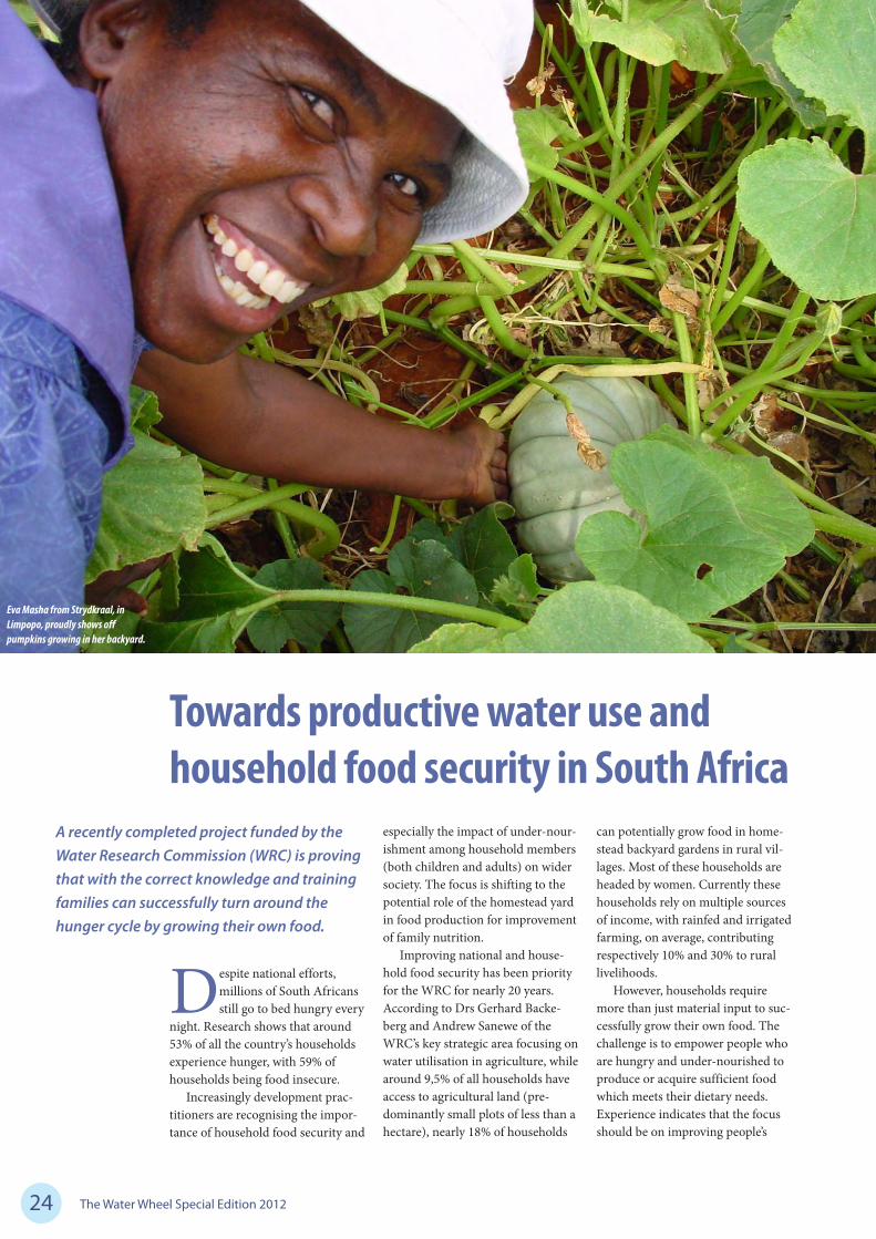
A recently completed project funded by the Water Research Commission (WRC) is proving that with the correct knowledge and training families can successfully turn around the hunger cycle by growing their own food.
Eva Masha from Strydkraal, in Limpopo, proudly shows off pumpkins growing in her backyard.
The Water Wheel Special Edition 2012 25
Food security
knowledge through informal, practi-cal, on the ground training and skills improvement.
PARTICIPATORY RESEARCH
Early in 2004, the WRC solicited a research project to develop
training material for agricultural water use in homestead farming systems. The emphasis was placed on participatory research and, as such, households from vari-ous communities around South Africa were included throughout the project cycle. This approach emphasised the participation of farmers in the generation, testing and evaluation of technology to increase or promote sustainable agricultural production.
The overall objective of the project was to improve food secu-rity through homestead gardening, by developing and evaluating the appropriateness and acceptability of training material for water use management, training the trainers and training of household members in selected areas.
The resultant resource material for facilitators and food gardeners deal with (among others) produc-tion potential, water supply and management, dietary requirements for balance nutrition, poverty alle-viation, participatory rural appraisal and applicable adult educational approaches within rural social struc-tures. In addition, the specific tech-niques and infrastructure required to harvest and conserve rain, cultivate soils and produce crops that will impact on the essential dietary needs of people living with limited means and opportunities are explained and illustrated.
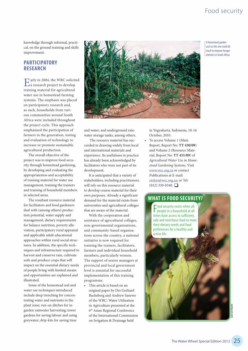
Some of the homestead soil and water use techniques introduced include deep trenching for concen-trating water and nutrients in the plant zone; run-on ditches for in-garden rainwater harvesting; tower gardens for saving labour and using greywater; drip-kits for saving time
WHAT IS FOOD SECURITY?
Food security exists when all people in a household at all
times have access to sufficient, safe and nutritious food to meet their dietary needs and food preferences for a healthy and active life.
and water; and underground rain-water storage tanks, among others.
The resource material has suc-ceeded in drawing widely from local and international materials and experience. Its usefulness in practice has already been acknowledged by facilitators who were not part of its development.
It is anticipated that a variety of stakeholders, including practitioners, will rely on this resource material to develop course material for their own purposes. Already a significant demand for the material exists from universities and agricultural colleges that are aware of the material.
With the cooperation and assistance of agricultural colleges, non-governmental organisations, and community-based organisa-tions across the country, a national initiative is now required for training the trainers, facilitators, farmers and individual household members, particularly women. The support of senior managers at provincial and local government level is essential for successful implementation of this training programme.• This article is based on an
original paper by Drs Gerhard Backeberg and Andrew Sanewe of the WRC: Water Utilisation in Agriculture presented at the 6th Asian Regional Conference of the International Commission on Irrigation & Drainage held
in Yogyakarta, Indonesia, 10-16 October, 2010.
• To access Volume 1 (Main Report, Report No: TT 430/09) and Volume 2 (Resource Mate-rial, Report No: TT 431/09) of Agricultural Water Use in Home-stead Gardening Systems, Visit www.wrc.org.za or contact Publications at E-mail: [email protected]; or Tel: (012) 330-0340.
A homestead garden such as this one could do much to improve hunger statistics in South Africa.
Lani
van V
uuren

The Water Wheel Special Edition 201226
Irrigation schemes
Despite the challenges associated with operating an 80-year-old irrigation scheme, the Lower Olifants River Water User Association (LORWUA) is successfully supporting one of the most important agricultural areas in the country while continuously striving for water use efficiency. Lani van Vuuren reports.
Modernisation of farming has taken place in the Olifants River Catch-
ment, in the Western Cape, since the arrival of Dutch settlers in the 1600s. Farmers initially planted crops in the fine alluvial deposits on the banks of the river. The first dam (Bulshoek) and associated canals were constructed just after the First World War. This was followed by the construction, through labour-inten-sive methods, of the Clanwilliam
WATER USE EFFICIENCY – Irrigators take the lead in Lower Olifants
Dam and additional open canals in the 1930s (for more information on the history of the scheme, see Water Wheel, September/October, 2010).
Today, the scheme comprises the Bulshoek and Clanwilliam dams, as well as a main canal split into a left bank canal of 136 km and a right bank canal of 123 km. A total of 1 052 sluices are used to draw off water for a scheduled area of 9 510 ha.
Apart from a betterment scheme in the 1960s which saw the canals
The canal at Ebenhaeser settlement at the lower end of the Lower Olifants River scheme.
Lani
van V
uuren

The Water Wheel Special Edition 2012 27
Irrigation schemes
WATER USE EFFICIENCY – Irrigators take the lead in Lower Olifants
being lined with concrete, the canal system has had no major refurbish-ment. Yet this antiquated system is hardly obsolete. The semi-arid region receives only about 152 mm of rain per year, and without the system irrigated agriculture would be impos-sible. Irrigated agriculture is by far the largest employer here, and the Lower Olifants scheme supports a burgeon-ing wine and table grape sector, sup-plemented by other produce such as tomatoes, vegetables, deciduous fruits and citrus. Apart from commercial farmers, the canal system also feeds an emerging farming community at Ebenhaeser, agriculture-related industry as well as seven small towns dotted along the West Coast.
“The region is about 90% dependent on agriculture and its associated industries,” reports LORWUA CEO Johan Matthee. “If irrigators are having a tough time and their buying power recedes, the effect can be felt by town businesses almost immediately. The sector also generates a considerable income for the State. Excise duties from the Lower Olifants Valley alone totals around R480-million a year.”
MANAGING WATER DEMAND
LORWUA was the first water user association to become operative
in South Africa following the prom-ulgation of the National Water Act in 1998, and has been operational since 2001. The scheme is subdivided into eight sub-districts or wards managed by seven water control officers. Each water control officer serves around 150 clients.
The Lower Olifants River scheme is among a growing num-ber of schemes benefiting from the
international award-winning Water Administration System (WAS). The system, developed by Dr Nico Benadé with funding from the Water Research Commission (WRC) enables accurate and real-time col-lection of data regarding water levels, volumes and abstractions, and over-all, has assisted irrigation schemes to realise huge improvements in water losses. Nationally, the system saves irrigation schemes more than 85 million m3 (21%) of water.
At LORWUA, irrigators request their water through strategically placed post boxes dotted across the scheme. Water allocation periods run from Mondays 06:00 to 06:00 the following Monday. The Lower
Olifants River scheme is rather unique in the country in that it runs at 6-hourly intervals for the calcula-tion of water distribution rather than the usual 12 and the WAS modules
they use have been adapted for this purpose. The schemes also operates on a ‘rolbeurt’ (revolving chance) system, which means that farmers are not allowed to order water with the same starting day every week. This is done to ensure the maximum volume of water is placed in the canal without exceeding the maxi-mum abstraction right.
LORWUA has a number of com-puters linked to a network, which means that the water orders can be captured on WAS simultaneously and in a short time period. Matthee reports that the WAS plays an enormously important role at the scheme. “WAS provides improved control of water orders (both current and historic), while the record of monthly accounts and reports that can be generated using the system are irreplaceable.”
Cancellations and additional water requests need to be done 72 hours in advance. The scheme has 30 water control aids who patrol the scheme (each one being responsible for a 6-10 km section) on bicycle and open and close sluices three times a day. Strict rules apply to water users on the scheme. No interference with sluices or the system is allowed.
“WAS provides improved control of water orders (both current and historic), while the record of
monthly accounts and reports that can be generated using the system are irreplaceable.”
The 127-million m3 Clanwilliam Dam is the main supplier of water to the Lower Olifants River scheme.
Lani
van V
uuren

The Water Wheel Special Edition 201228
Irrigation schemes
Those found taking more than their share can have their sluices painted red for all to see (name and shame).
Measuring the water that goes into the system is an extremely important part of the manage-ment of such an irrigation scheme. LORWUA has placed additional measuring stations at the start and end of each sub-district with the associated telemetry. V-notches have been installed, and more improvements are planned for the future.
According to Matthee, the great-est challenge on the scheme is ensur-ing that each irrigator or water user receives fair share of water on time. “The scheme is over-scheduled and the canal is physically too small to transport all the water required. In addition, the capacity of the Clanwil-liam Dam is inefficient to meet the water requirements of the scheduled area.” While the yearly quota is 12 200 m3/ha, the limited capacity of the canal allows for a maximum extraction rate of 325 m3/ha each
“If irrigators are having a tough time and their buying power recedes,
the effect can be felt by town businesses almost
immediately.”
Above: Most water losses are occurring as a result of the bad state of the concrete in the canal.
Below: Strandfontein is one of six little towns dependent on water from the Lower Olifants River scheme.
Lani
van V
uuren
Lani
van V
uuren
week. Between October and middle-May (the water year) the scheme is only able to supply 8 200 m3/ha.
Raising of the Clanwilliam Dam by 13 m is on the cards. This will increase the water supplied from the dam by 70 million m3/year. However, this will require raising and strength-ening the canal system. “Practically, it will be a real challenge supply-ing water and undertaking canal improvements at the same time,” says Matthee. The feasibility of this R1,8-billion project, which will have to be undertaken simultaneously with the raising of the dam, is currently being investigated by the departments of agriculture and water affairs.
Meanwhile the current limita-tions of the scheme have caused irri-gators themselves to become more water efficient. Flood irrigation has largely been replaced by drip irriga-tion, especially since the drought year experienced in 2003/04. This has resulted in substantial water sav-ings per hectare.
CHALLENGES TO THE OPERATION
Despite these challenges the water user association has
managed to reduce water losses from 48% (in 2002) to 24%. When one considers that the average losses on open canal systems are between 40% and 50%, this is an extremely good number. Water is now mainly lost to breakages and leaks in the system. Evaporation out of the canals caused by hot temperatures and winds also contributes to water losses.
LORWUA has gone out of its way to ensure that not a drop of water on the scheme is wasted unneces-sarily. An evaluation of the state of

The Water Wheel Special Edition 2012 29
Irrigation schemes
infrastructure in 2003 highlighted areas in need of most urgent atten-tion. Since 2002 the water user association has spent around R3,5-million each year to improve the state of concrete canals. This work is considerable when one realises that only 11 weeks of the year can be set aside for maintenance.
Last year the water user asso-ciation did major repair work to the concrete in two high-risk sections of the canal (13 km in total) at a total cost of R11-million. “This summer we are reaping the benefits of this improvement, however, no water user association can afford to finance these kinds of repairs on a regular basis themselves,” notes Matthee.
The scheme’s siphons are also receiving attention. In 2009, LORWUA, with financial assistance from the Department of Water Affairs, replaced the largest siphon on the scheme (2,1 m diameter) at a cost of R24-million. A further five siphons need to be replaced and funding is being sought in this regard.
Unfortunately the Lower Olifants River scheme suffered a major set-back in December. On 15 December 170 mm of rain fell within 24 hours between Lutzville and Koekenaap (The rest of the scheme received about 70 mm of rain). Despite LORWUA’s efforts the resultant floods caused great damage to the canal infrastructure amounting to R2,5-million. Stormwater and sedi-ment resulted in canal breakages at five sites, while large parts of the canal became blocked due to sedi-ment and debris. Heavy machinery, including diggers, loaders and dump trucks, along with 80 work-ers, cleared the canals, and pumps were used to supply water to users at the lower end of the scheme. The mopping up exercise lasted until 31 December.
Despite these setbacks the Lower Olifants River scheme remains an important example of effective water management to achieve water savings in the irriga-tion sector.
Many farmers make use of balancing dams (so-called ‘oornag damme’) to tie them over between water orders.
Today, the Lower Olifants River is known for its vineyards. Most farmers have replaced flood irrigation with drip irrigation techniques to save water. La
ni va
n Vuu
renLa
ni va
n Vuu
ren

The Water Wheel Special Edition 201230
Water use in agriculture
IMPROVED WATER USE ONLY A SATELLITE AWAY
Sugarcane growers in one of the country’s most overexploited catchments will soon have the aid of cutting-edge satellite technology to improve their
water-use efficiency and up their production. Article by Lani van Vuuren.
Lani
van V
uuren
The Water Wheel Special Edition 2012 31
Water use in agriculture
Lani
van V
uuren
When travelling through the Inkomati area, in Mpumalanga, one can-
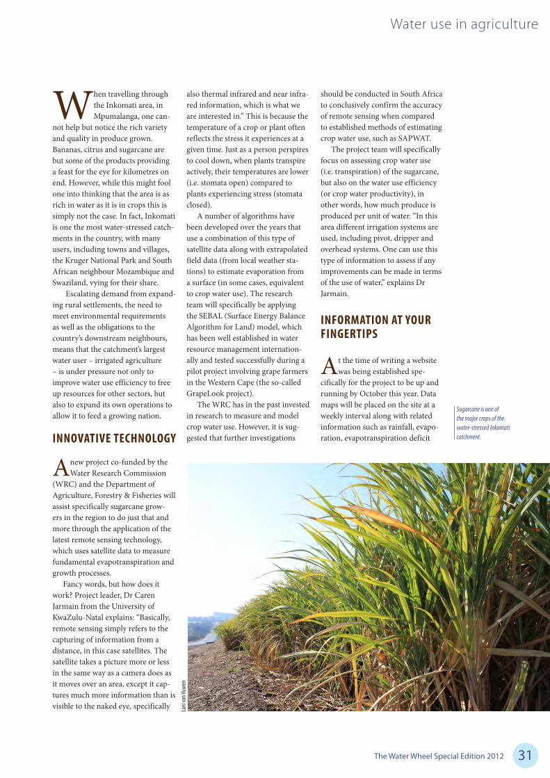
not help but notice the rich variety and quality in produce grown. Bananas, citrus and sugarcane are but some of the products providing a feast for the eye for kilometres on end. However, while this might fool one into thinking that the area is as rich in water as it is in crops this is simply not the case. In fact, Inkomati is one the most water-stressed catch-ments in the country, with many users, including towns and villages, the Kruger National Park and South African neighbour Mozambique and Swaziland, vying for their share.
Escalating demand from expand-ing rural settlements, the need to meet environmental requirements as well as the obligations to the country’s downstream neighbours, means that the catchment’s largest water user – irrigated agriculture – is under pressure not only to improve water use efficiency to free up resources for other sectors, but also to expand its own operations to allow it to feed a growing nation.
INNOVATIVE TECHNOLOGY
A new project co-funded by the Water Research Commission
(WRC) and the Department of Agriculture, Forestry & Fisheries will assist specifically sugarcane grow-ers in the region to do just that and more through the application of the latest remote sensing technology, which uses satellite data to measure fundamental evapotranspiration and growth processes.
Fancy words, but how does it work? Project leader, Dr Caren Jarmain from the University of KwaZulu-Natal explains: “Basically, remote sensing simply refers to the capturing of information from a distance, in this case satellites. The satellite takes a picture more or less in the same way as a camera does as it moves over an area, except it cap-tures much more information than is visible to the naked eye, specifically
also thermal infrared and near infra-red information, which is what we are interested in.” This is because the temperature of a crop or plant often reflects the stress it experiences at a given time. Just as a person perspires to cool down, when plants transpire actively, their temperatures are lower (i.e. stomata open) compared to plants experiencing stress (stomata closed).
A number of algorithms have been developed over the years that use a combination of this type of satellite data along with extrapolated field data (from local weather sta-tions) to estimate evaporation from a surface (in some cases, equivalent to crop water use). The research team will specifically be applying the SEBAL (Surface Energy Balance Algorithm for Land) model, which has been well established in water resource management internation-ally and tested successfully during a pilot project involving grape farmers in the Western Cape (the so-called GrapeLook project).
The WRC has in the past invested in research to measure and model crop water use. However, it is sug-gested that further investigations
should be conducted in South Africa to conclusively confirm the accuracy of remote sensing when compared to established methods of estimating crop water use, such as SAPWAT.
The project team will specifically focus on assessing crop water use (i.e. transpiration) of the sugarcane, but also on the water use efficiency (or crop water productivity), in other words, how much produce is produced per unit of water. “In this area different irrigation systems are used, including pivot, dripper and overhead systems. One can use this type of information to assess if any improvements can be made in terms of the use of water,” explains Dr Jarmain.
INFORMATION AT YOUR FINGERTIPS
At the time of writing a website was being established spe-
cifically for the project to be up and running by October this year. Data maps will be placed on the site at a weekly interval along with related information such as rainfall, evapo-ration, evapotranspiration deficit
Sugarcane is one of the major crops of the water-stressed Inkomati catchment.
Lani
van V
uuren

The Water Wheel Special Edition 201232
Water use in agriculture
(the difference between evaporation losses and the potential evaporation of the crop), crop production (bio-mass) and derivatives (rainfall minus evaporation). Organisations par-ticipating in the research, including farmers, irrigation consultants and the catchment management agency, will be able to assess how much water was used by the sugarcane over a week period in relation to the irrigation applied by the farmer.
“Uniformity of evaporation losses over an irrigation block can be
assessed using the data and adjust-ments made,” notes Dr Jarmain. “The evapotranspiration deficit data, in turn, can be used to determine if plants in a specific block are experi-encing any water stress and adjust-ments to irrigation systems and/or applications can be made accord-ingly. The fact that all information is provided spatially is very valuable, since farmers generally strive towards uniformity over an irrigation block.”
There are several challenges in this regard, firstly the timely delivery
of good quality (i.e. cloud-free) remote sensing data. “For an opera-tional system to deliver information at a weekly time-step, a good quality image needs to be captured each week and be delivered soon after data capture so that the processing can be performed in time,” explains Dr Jarmain. The project also hopes to promote this approach, and therewith gain participation, from as many sugarcane farmers as possible.
TSB Sugar, one of the leading producers of sugar in the country, has already confirmed its support for the project. According to Dr Pieter Cronjé, Manager: Grower Affairs, it is hoped that this technology will contribute to highlighting areas requiring more attention. “The northern sector of the sugar industry is highly dependent on irrigation, and any system that can assist in the strategic management of a scarce resource will contribute to sustainability. The Inkomati area also features some large estates where production is monitored very thoroughly, and the space-based system will enable managers to pin-point inefficiencies more accurately while explaining lower than expected yields, thus guiding management interventions.”
Dr Cronjé explains that the optimum production of sugarcane requires a significant amount of water. Water use measurement among sugarcane farmers in the area vary from no measurement at all to remote sensors with data logging and transmission to a central point. Unfortunately, irrigation is still mostly based on irrigation systems’ design capacity rather than might be required by the plant or soil at any given point in time. “As a result we have experienced gross over-irriga-tion on several farms. TSB Sugar has been running an awareness cam-paign in this regard for several years. Where proper irrigation scheduling has been applied, production has improved up to 15%. We anticipate that the WRC project will further aid
Above: Sugarcane from the Inkomati basin contributes to nearly 20% of total sugar production in South Africa.
Below: Young shoots of sugarcane standing under irrigation outside Malelane, in Mpumalanga.
Lani
van V
uuren
Lani
van V
uuren

The Water Wheel Special Edition 2012 33
Water use in agriculture
in highlighting these inefficiencies and lead to a better management system.”
ENHANCING CAPACITY
From a research point of view the project has several important
aims, firstly to present this novel technology to South African irriga-tion farmers. Dr Jarmain is of the strong opinion that this technology has the potential to assist farmers to improve their production, however, cooperation is required between farmers and researchers to ensure that the information is presented in a way that is most useful.
At the same time, very little expertise in this technology in South Africa currently exists, and the pro-ject will be exposing students to this type of remote sensing and its poten-tial for water management in South Africa. Lastly, Dr Jarmain notes that many national departments can benefit from data generated using this type of technology. “Illustrating to the departments of Water Affairs as well as Agriculture, Forestry & Fisheries how this type of informa-tion can be used can greatly increase the use of this type of data. This obviously relates directly to capacity building.”
A similar study is also being planned for irrigated grain crops in the Middle-Orange River catchment as part of this project. The WRC project is also set to benefit from an upcoming European Union study, WATPLAN, which will be conducted simultaneously in the Inkomati catchment. This research project is aimed at integrated SEBAL estimates of crop water use to catchment scale, thereby ensuring that international obligations in terms of water delivery and management, is met.
Remote sensing technology will only improve over time in terms of how many satellites are available, how frequently data is captured, at which resolution data is captured and the costs at which the data is made available, maintains
Dr Jarmain. “Hopefully in a few years’ time satellite constellations will be available that can capture data daily at high resolutions, finer than the frequency currently used (30 m by 30 m).”
NATIONAL IMPORTANCE
For a large country such as South Africa, with huge variations
across the landscape this technol-ogy can really add value not only for determining water use of agricul-tural crops (dryland and irrigated) but also of invasive alien plants, natural veld and forestry, to name but a few. Data can be shown in the form of maps or integrated at field, farm, region, catchment, province or whichever scale is required. ‘Water accounts’ can also be determined at different scale, especially catchment level.
It is clear that the application of this technology has far greater potential than just improving crop production, as WRC Director: Water Utilisation in Agriculture, Dr Gerhard Backeberg, points out: “The last reliable assessment of the area of different crops under irriga-tion in South Africa was published by the WRC 15 years ago (WRC Report No: KV96/96). It is impor-tant to determine the current area under irrigation, cropping patterns and water use across all farming types and irrigation schemes. In order to improve the efficiency of consumptive water use it is essen-tial to increase beneficial crop transpiration and limit non-ben-eficial soil evaporation within the water balance. By achieving this, the productivity, competitiveness, profitability and sustainability of food production under irrigation will improve.”
“The accessibility of satel-lite images ensures data flow on changes in water use. The most important benefit is to monitor how changes in land use and consump-tive water use affect water availabil-ity in different catchment areas,”
THE SOUTH AFRICAN SUGAR INDUSTRY
South Africa is one of the world’s leading producers of high-quality sugar, with about 35 300 registered sugar-
cane growers farming predominantly in KwaZulu-Natal, Mpumalanga and the Eastern Cape.
Sugar is manufactured by six milling companies with 14 sugar mills operating in the main cane-growing regions. The industry produces about 2,2 million tons of sugar per season, of which 60% is marketed in the southern African Customs Union. The remainder is exported to countries in Africa, Asia and the Middle East.
The sector makes an important contribution to the local economy, and directly employs around 77 000 people – this represents a significant percentage of the total agricultural workforce in the country. When considering those indirectly employed by the sector it is estimated that about one million people in South Africa depend on the sugar industry for a living.
Source: South African Sugar Association
Dr Backeberg continues. “In addi-tion, a data platform is generated with a range of applications. This, in turn, creates opportunities for service providers such as irrigation scheduling and soil fertilisation advice, plant disease and electric-ity cost control. Apart from more productive agricultural water use, many new business and employ-ment opportunities will therefore arise in rural economies.”
Readers interested in partici-pating in the project, Water Use Efficiency of Irrigated Agricul-tural Crops Determined by Satel-lite Imagery (WRC Project No: K5-2079) can contact the Editor for further information.

The Water Wheel Special Edition 201234
According to the Milk Producers’ Association, South Africa’s dairy farm-
ers are expected to produce 2 460 million litres of milk for 2012. As the human population increases and diets become more affluent, so the demand for animal protein (such as milk) increases. At the same time, farmers are under pressure to decrease their share of water and fertiliser usage.
No wonder then that of all farm-ing enterprises dairy farming places the highest demand on advanced technology. Expert knowledge is not only required for milking, but also to provide the milking cow with the kind of nutrition that will allow her to produce the optimum amount of quality milk.
THE NEED FOR PASTURES
As a result of South Africa’s variable climate, general water
scarcity, and often marginal soils, it is not unusual for dairy farmers to supplement their herds’ feed with irri-gated pastures. It is estimated that the total area utilised for irrigated pasture production is about 16% of the total area under irrigation in South Africa.
Irrigated annual ryegrass (Lolium multiflorum) is the
primary sources of feed in the pasture-based dairy industry, and is mostly grown in the relatively higher rainfall areas, particularly the KwaZulu-Natal Midlands, Eastern Highveld, Eastern Cape and in the winter rainfall areas of South Africa. Annual ryegrass has high nutritional qualities, palat-ability, digestible energy, protein and mineral contents, playing an essential role in supplying good quality grazing between the winter and summer seasons. On the other hand, kikuyu (Pennisetum clandes-tinum) is the predominant summer grass pasture used for milk produc-tion along the east coast of South Africa.
Although management of dairy farming has now attained unprecedented levels of technology due largely to the availability of
New WRC guidelines helping dairy farmers to greener pastures
New irrigation guidelines for pasture production developed under the auspices of the Water Research Commission (WRC) are proving to farmers that with the efficient application of water and fertiliser the grass can be greener on their side of the fence. Article compiled by Lani van Vuuren.
Pasture irrigation

The Water Wheel Special Edition 2012 35
Pasture irrigation
practical equipment and methods for managing (specifically planning and monitoring) most facets of dairy farming, this does not apply to the irrigation of pastures. In spite of the increasing role of pas-tures in milk production, farmers still generally rely on experience and tradition even for managing the most important pasture pro-duction factors.
Irrigation water and nutrients are resources that can be optimised by selecting an appropriate irriga-tion type, scheduling technique and pasture type. For sustainable pasture production, the best pos-sible fertiliser and water regimes are required in order to attain high biomass yield with minimum inputs, which maximises profit while minimising the impact on the environment. The most appro-priate and cost-effective manage-ment strategy would therefore be to integrate irrigation and nutrient (especially nitrogen) inputs, since nitrogen and water cannot be man-aged independently.
Despite the latest fertiliser and irrigation application equip-ment and scientifically-based guidelines, knowledge gaps have been identified between research and farming practices. A number of experiments have been car-ried out throughout the country on the effect of nitrogen on yield and quality of grass pastures; however, there is a lack of reliable information and data pertaining to ryegrass water requirements to facilitate efficient irrigation management.
To fill some of these knowledge gaps the WRC funded a five-year solicited project to study the irri-gation management of ryegrass and kikuyu pastures under differ-ent management conditions. The research was undertaken by the uni-versities of KwaZulu-Natal (UKZN) and Pretoria (UP) along with the CSIR. The main objective was to study water use of these pastures, with field experiments undertaken
over a period of two years at two agricultural research sites (in Pretoria and KwaZulu-Natal). This has led to the recent publication of water use and irrigation guidelines for the major pasture growing areas of South Africa.
FIELD TRIALS
At UP’s Hatfield experimental farm and UKZN’s Cedara
research station experiments were conducted to determine the effects of different water levels in combi-nation with different nitrogen fer-tiliser applications on the growth rate and dry matter production, quality, water use and water use efficiency of annual ryegrass for two seasons.
The experiments showed that irrigation and nitrogen fertiliser affected yield and leaf area signifi-cantly. Higher frequency of irriga-tion coupled with high fertiliser application greatly improved dry matter yield. Interestingly, there was no significant difference in yield between the treatments that were irrigated twice weekly and once weekly at the high nitrogen
application. In fact, the decrease in the frequency of water applica-tion (and the resultant water stress) resulted in a generally superior end product. The highest water use efficiency was achieved by irrigat-ing once every two weeks. The study concluded that by irrigating once a week and fertilising with high nitrogen application rate after each harvest, optimum yield can be achieved with better quality pasture and a better water use efficiency.
MODELLING COMPONENTS
During the WRC project the use of numerical models was
investigated for achieving opti-mised growth of ryegrass through efficient use of water and nitrogen fertilisation. Several crop models were tested, and in the end the Soil Water Balance (SWB) model was used. This model is already being used extensively to simulate crop growth and soil water balance of several cereals, vegetables and tree crops. The model is available on the Web and can be downloaded free of charge.
South Africa’s semi-arid climate leaves farmers no choice but to supplement their livestock’s feed.
Grae
me W
illiam
s/Med
ia Clu
b Sou
th Af
rica
Lani
van V
uuren
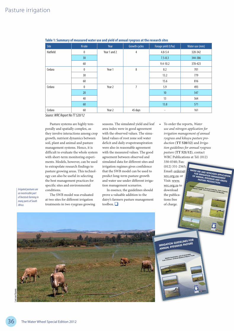
The Water Wheel Special Edition 201236
Pasture irrigation
Pasture systems are highly tem-porally and spatially complex, as they involve interactions among crop growth, nutrient dynamics between soil, plant and animal and pasture management systems. Hence, it is difficult to evaluate the whole system with short-term monitoring experi-ments. Models, however, can be used to extrapolate research findings to pasture growing areas. This technol-ogy can also be useful in selecting the best management practices for specific sites and environmental conditions.
The SWB model was evaluated at two sites for different irrigation treatments in two ryegrass growing
seasons. The simulated yield and leaf area index were in good agreement with the observed values. The simu-lated values of root zone soil water deficit and daily evapotranspiration were also in reasonable agreement with the measured values. The good agreement between observed and simulated data for different sites and irrigation regimes gives confidence that the SWB model can be used to predict long-term pasture growth and water use under different irriga-tion management scenarios.
In essence, the guidelines should prove a valuable addition to the dairy’s farmers pasture management toolbox.
• To order the reports, Water use and nitrogen application for irrigation management of annual ryegrass and kikuyu pasture pro-duction (TT 520/12) and Irriga-tion guidelines for annual ryegrass pasture (TT 521/12), contact WRC Publications at Tel: (012) 330-0340; Fax: (012) 331-2565; Email: [email protected]; or Visit: www.wrc.org.za to download the publica-tions free of charge.
Table 1: Summary of measured water use and yield of annual ryegrass at the research sitesSite N rate Year Growth cycles Forage yield (t/ha) Water use (mm)
Hatfield 0 Year 1 and 2 4 4.8-5.4 320-342
30 7.5-8.3 344-386
60 9.4-10.2 378-423
Cedara 0 Year 1 8 8.2 701
30 13.2 779
60 15.6 816
Cedara 0 Year 2 7 5.9 493
20 10 547
40 13 564
60 13.8 571
Cedara 60 Year 2 45 days - 161
F
I
N
A
L
R
E
P
O
R
T
T
O
T
H
E
W
A
T
E
R
R
E
S
E
A
R
C
H
C
O
M
M
I
S
S
I
O
N
M
e
l
a
k
e
K
F
e
s
s
e
h
a
z
i
o
n
,
A
m
a
n
u
e
l
B
A
b
r
a
h
a
,
C
o
l
i
n
S
E
v
e
r
s
o
n
,
W
a
y
n
e
F
T
r
u
t
e
r
,
J
o
h
n
G
A
n
n
a
n
d
a
l
e
&
M
M
o
o
d
l
e
y
W
R
C
R
E
P
O
R
T
N
O
.
#
#
#
#
P
R
O
J
E
C
T
N
O
.
K
5
/
1
6
5
0
IS
B
N
N
O
.
:
#
#
#
#
O
C
T
O
B
E
R
2
0
1
1
W
A
T
E
R
U
S
E
A
N
D
N
I
T
R
O
G
E
N
A
P
P
L
I
C
A
T
I
O
N
F
O
R
I
R
R
I
G
A
T
I
O
N
M
A
N
A
G
E
M
E
N
T
O
F
A
N
N
U
A
L
R
Y
E
G
R
A
S
S
A
N
D
K
I
K
U
Y
U
P
A
S
T
U
R
E
P
R
O
D
U
C
T
I
O
N
TT 520/12
TT 520/12 Water Use and Nitrogen Application for Irrigation Managem
ent of Annual Ryegrass and Kikuyu Pasture Production
1
1
1
,2
M
e
la
k
e
F
e
s
s
e
h
a
z
io
n
,
J
o
h
n
G
.
A
n
n
a
n
d
a
le
,
C
o
li
n
S
.
E
v
e
rs
o
n
,
1
1
A
m
a
n
u
e
l
A
b
ra
h
a
a
n
d
W
a
y
n
e
F
.
T
ru
t
e
r
1
D
e
p
a
rt
m
e
n
t
o
f
P
la
n
t
P
ro
d
u
c
t
io
n
a
n
d
S
o
il
S
c
ie
n
c
e
,
U
n
iv
e
rs
it
y
o
f
P
re
t
o
ri
a
,
P
ri
v
a
t
e
b
a
g
X
2
0
,
H
a
t
f
ie
ld
,
P
re
t
o
ri
a
,
0
0
2
8
2
U
n
iv
e
rs
it
y
o
f
K
w
a
Z
u
lu
-
N
a
t
a
l,
P
ri
v
a
t
e
B
a
g
X
0
1
,
S
c
o
t
t
s
v
il
le
,
P
ie
t
e
rm
a
ri
t
z
b
u
rg
,
3
2
0
9
.
F
IN
A
L
R
E
P
O
R
T
T
O
T
H
E
W
A
T
E
R
R
E
S
E
A
R
C
H
C
O
M
M
IS
S
IO
N
W
R
C
R
E
P
O
R
T
N
O
.
#
#
#
#
P
R
O
J
E
C
T
N
O
.
K
5
/
1
6
5
0
IS
B
N
N
O
.
:
#
#
#
#
O
C
T
O
B
E
R
2
0
1
1
F
I
N
A
L
R
E
P
O
R
T
T
O
T
H
E
W
A
T
E
R
R
E
S
E
A
R
C
H
C
O
M
M
I
S
S
I
O
N
M
e
l
a
k
e
F
e
s
s
e
h
a
z
i
o
n
,
J
o
h
n
G
A
n
n
a
n
d
a
l
e
,
C
o
l
i
n
S
E
v
e
r
s
o
n
,
A
m
a
n
u
e
l
A
b
r
a
h
a
&
W
a
y
n
e
F
T
r
u
t
e
r
TT 521/12
Irrigated pastures are an inextricable part of livestock farming in many parts of South Africa.
Lani
van V
uuren
Source: WRC Report No TT 520/12
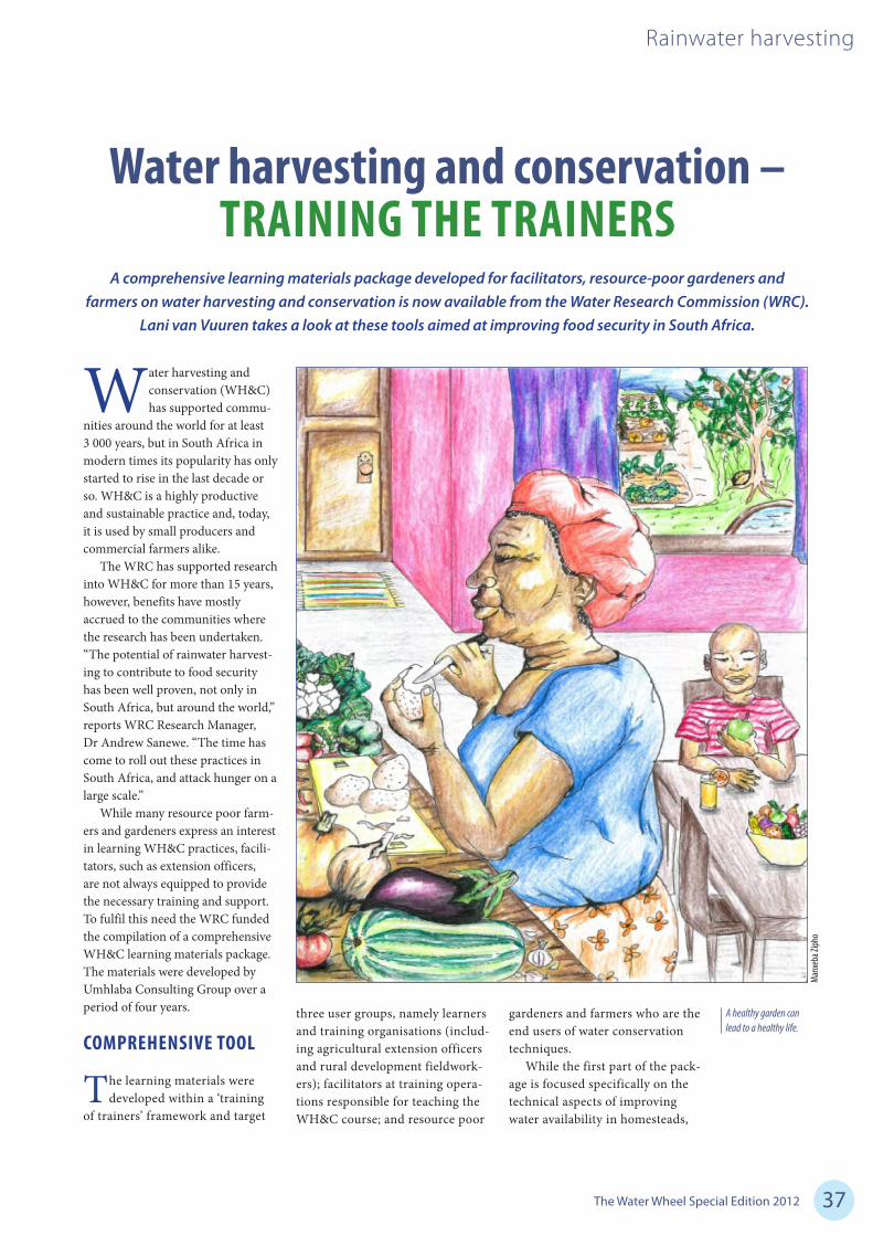
The Water Wheel Special Edition 2012 37
Rainwater harvesting
Water harvesting and conservation (WH&C) has supported commu-
nities around the world for at least 3 000 years, but in South Africa in modern times its popularity has only started to rise in the last decade or so. WH&C is a highly productive and sustainable practice and, today, it is used by small producers and commercial farmers alike.
The WRC has supported research into WH&C for more than 15 years, however, benefits have mostly accrued to the communities where the research has been undertaken. “The potential of rainwater harvest-ing to contribute to food security has been well proven, not only in South Africa, but around the world,” reports WRC Research Manager, Dr Andrew Sanewe. “The time has come to roll out these practices in South Africa, and attack hunger on a large scale.”
While many resource poor farm-ers and gardeners express an interest in learning WH&C practices, facili-tators, such as extension officers, are not always equipped to provide the necessary training and support. To fulfil this need the WRC funded the compilation of a comprehensive WH&C learning materials package. The materials were developed by Umhlaba Consulting Group over a period of four years.
COMPREHENSIVE TOOL
The learning materials were developed within a ‘training
of trainers’ framework and target
three user groups, namely learners and training organisations (includ-ing agricultural extension officers and rural development fieldwork-ers); facilitators at training opera-tions responsible for teaching the WH&C course; and resource poor
gardeners and farmers who are the end users of water conservation techniques.
While the first part of the pack-age is focused specifically on the technical aspects of improving water availability in homesteads,
Water harvesting and conservation – TRAINING THE TRAINERS
A comprehensive learning materials package developed for facilitators, resource-poor gardeners and farmers on water harvesting and conservation is now available from the Water Research Commission (WRC).
Lani van Vuuren takes a look at these tools aimed at improving food security in South Africa.
A healthy garden can lead to a healthy life.
Man
xeba
Ziph
o
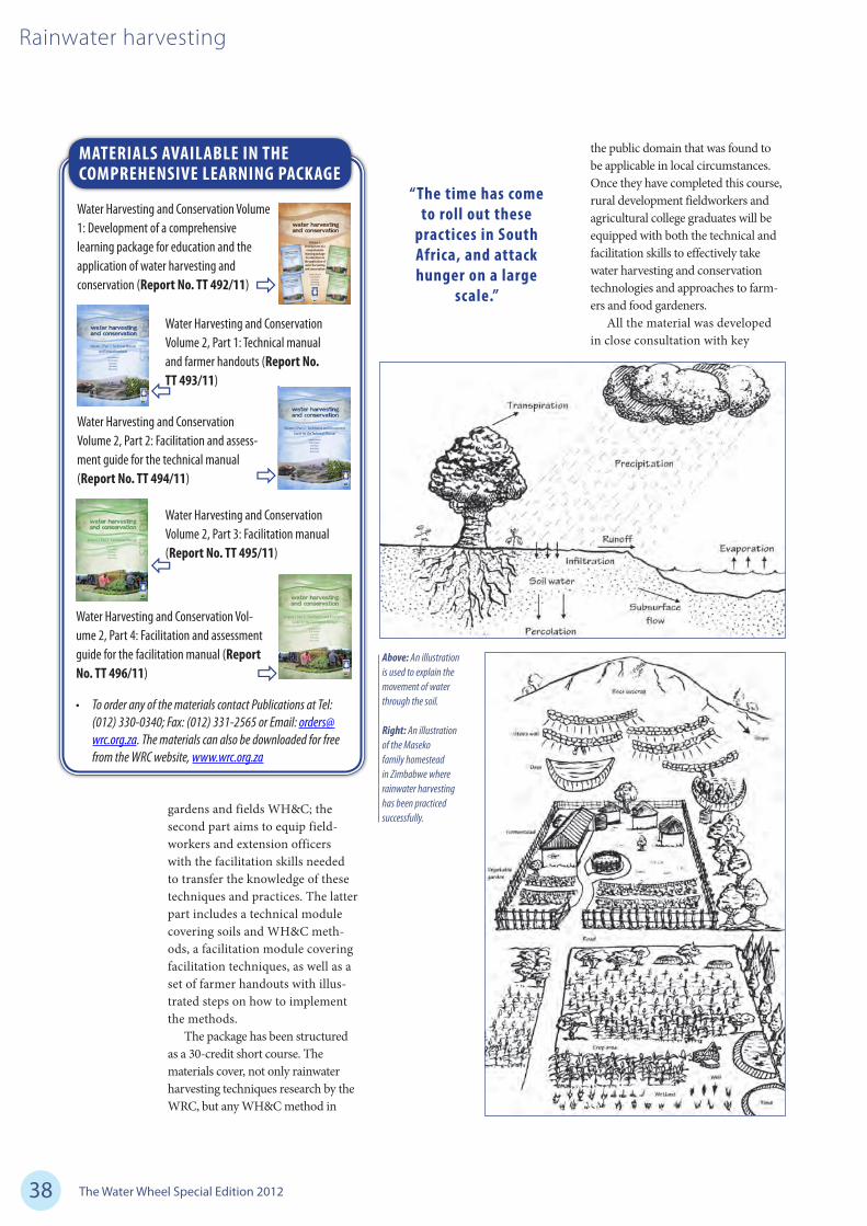
The Water Wheel Special Edition 201238
Rainwater harvesting
MATERIALS AVAILABLE IN THE COMPREHENSIVE LEARNING PACKAGE
Water Harvesting and Conservation Volume 1: Development of a comprehensive learning package for education and the application of water harvesting and conservation (Report No. TT 492/11)
Volume 2 Part 4: Facilitation and Assessment Guide for the Facilitation Manual
Jonathan DenisonHeidi Smulders
Erna KrugerHlubi NdingiMarius Botha
TT 496/11
TT 496/11 Water Harvesting and Conservation Volum
e 2 Part 4: Facilitation and Assessment Facilitation and Assessm
ent Guide for the Facilitation Manual
Volume 2 Part 3: Facilitation Manual Jonathan Denison
Heidi SmuldersErna KrugerHlubi NdingiMarius Botha
TT 495/11
TT 495/11 Water Harvesting and Conservation Volum
e 2 Part 3: Facilitation Manual
Volume 2 Part 2: Facilitation and Assessment Guide for the Technical Manual
Jonathan DenisonHeidi Smulders
Erna KrugerHlubi NdingiMarius Botha
TT 494/11
TT 494/11 Water Harvesting and Conservation Volum
e 2 Part 2: Facilitation and Assessment Guide for the Technical M
anual
Volume 2 Part 1: Technical Manual and Farmer Handouts
Jonathan DenisonHeidi Smulders
Erna KrugerHlubi NdingiMarius Botha
TT 493/11
TT 493/11 Water Harvesting and Conservation Volum
e 2 Part 1: Technical Manual and Farm
er Handouts
Volume 1: Development of a
comprehensive learning package for education on
the application of water harvesting and conservation
Jonathan DenisonHeidi Smulders
Erna KrugerHlubi NdingiMarius Botha
TT 492/11
TT 492/11 Water Harvesting and Conservation Volum
e 1: Development of a com
prehensive learning package for education on the application of water harvesting and conservation
• To order any of the materials contact Publications at Tel: (012) 330-0340; Fax: (012) 331-2565 or Email: [email protected]. The materials can also be downloaded for free from the WRC website, www.wrc.org.za
Water Harvesting and Conservation Volume 2, Part 1: Technical manual and farmer handouts (Report No. TT 493/11)
Water Harvesting and Conservation Volume 2, Part 2: Facilitation and assess-ment guide for the technical manual (Report No. TT 494/11)
Water Harvesting and Conservation Volume 2, Part 3: Facilitation manual (Report No. TT 495/11)
Water Harvesting and Conservation Vol-ume 2, Part 4: Facilitation and assessment guide for the facilitation manual (Report No. TT 496/11)
gardens and fields WH&C; the second part aims to equip field-workers and extension officers with the facilitation skills needed to transfer the knowledge of these techniques and practices. The latter part includes a technical module covering soils and WH&C meth-ods, a facilitation module covering facilitation techniques, as well as a set of farmer handouts with illus-trated steps on how to implement the methods.
The package has been structured as a 30-credit short course. The materials cover, not only rainwater harvesting techniques research by the WRC, but any WH&C method in
the public domain that was found to be applicable in local circumstances. Once they have completed this course, rural development fieldworkers and agricultural college graduates will be equipped with both the technical and facilitation skills to effectively take water harvesting and conservation technologies and approaches to farm-ers and food gardeners.
All the material was developed in close consultation with key
“ The time has come to roll out these
practices in South Africa, and attack hunger on a large
scale.”
Above: An illustration is used to explain the movement of water through the soil.
Right: An illustration of the Maseko family homestead in Zimbabwe where rainwater harvesting has been practiced successfully.

The Water Wheel Special Edition 2012 39
Rainwater harvesting
stakeholders to ensure its relevance. According to the project team, there was a marked positive inter-est in water harvesting and general enthusiasm to have this new mate-rial embedded in existing curricula at agricultural colleges and higher education organisations. “The agricultural colleges in particular expressed specific and immediate need, such that some were willing to use the draft materials in their curricula.”
During a pilot process lasting six months 14 learners received training at the University of KwaZulu-Natal’s Centre for Adult Education. In a spin-off from the project, 68 students from the Walter Sisulu University Fine Art Department were finan-cially supported through fieldwork exposure and competition funding, to provide illustrations for the course materials.
FROM THEORY TO PRACTICE
The learning materials package has been structured to comply
with both the Unit Standard and the Quality Council for Trade and Occu-pations accreditation frameworks. Accreditation has proved to be a lengthy and complicated process, and the WRC remains in talks with the Department of Agriculture, For-estry and Fisheries (DAFF) to ensure the accreditation of the material.
It is now up to the trainer com-munity to ensure the material reaches as many fieldworkers and farmers as possible. “We believe in the potential of this learning pack-age to make a real difference in the lives of people,” notes Dr Sanewe. The materials fit in squarely with the DAFF’s Zero Hunger Cam-paign, aimed at eradicating hunger and food insecurity in South Africa
through the production of afford-able, good quality food.
“The materials will hopefully not only be used in the training courses of agricultural colleges, but also by community and non-governmental organisations,” adds Dr Sanewe. Workshops are being planned for different parts of the country to expand awareness of the learning package among potential disseminators. Extension officers and other fieldworkers will also be taken briefly through the material.
In the end, it is all about ensur-ing that no-one in South Africa goes to bed hungry at night. If you have the power to make a dif-ference it is your duty to make a difference.
Above: An artist’s impression of rainwater harvesting.
Top right: Water harvesting gives you food.
Top right: Water is wealth.
Luba
balo
Ntso
kont
oko
Bong
a Situ
mba
NY Bo
nkolo

The Water Wheel Special Edition 201240
Irrigation efficiency
The water requirements of irrigated agriculture in South Africa are estimated at 56%
of the total annual surface- and groundwater requirements in South Africa. Although the contribution of irrigation to total agricultural production varies according to crop type, most of this water is used for commercial food production in response to consumer demand. With increasing water demand from the domestic, mining and industrial sec-tors due to urbanisation and higher standards of living, more pressure is
being placed on agricultural water users to reduce consumption and so increase the amount of water avail-able for other uses. The implication is that more productive water use in future is essential.
According to Dr Gerhard Backe-berg, Director: Water Utilisation in Agriculture at the WRC, water users must understand the economic value and opportunity cost of water as a scarce resource and respond to incentives to use less water, which could then reduce the demand for sources in a river catchment. “For sustainable economic growth and development, the competitiveness of irrigated agriculture will continu-ously have to improve. This can be achieved through multifactor pro-ductivity growth. It requires that more food is produced through higher efficiency and without the use
of additional inputs, including that of water. The challenge for profitable farming is finding innovative ways of improving management, techno-logical progress and more efficient resource allocation.”
In addition to water scarcity, energy and operating costs affects water management and will do so increasingly in future. Energy prices are rising, pushing up the costs of pumping water, applying fertilis-ers and transporting products. This will have implications for the lawful access to existing water allocations and use for irrigation. “In order to make best use of available water and energy, it is imperative that we develop and manage irrigation water supply and application systems with demand in mind, so that we minimise our water footprint – to determine how little we can demand
Irrigation water use efficiency – It is all about balance
Following nearly a decade of extensive research the Water Research Commission (WRC) has published comprehensive guidelines towards improved efficiencies in the irrigation sector. Compiled by Lani van Vuuren.

The Water Wheel Special Edition 2012 41
Irrigation efficiency
from the water source rather than how much we can supply,” explains Dr Backeberg.
BALANCED APPROACH
The WRC already recognised in 2003 that the efficient use of
water by the irrigation sector will become increasingly important in the future. For this reason the Com-mission launched a major project to investigate and formulate guidelines to improve the management and use of water by irrigated agriculture in South Africa.
The resultant publication, Standards and Guidelines for Improved Efficiency of Irriga-tion Water Use from Dam Wall Release to Root Zone Application, introduces a relatively new con-cept, namely the water balance approach, for achieving the nec-essary efficiencies in irrigation. Project leader Felix Reinders, Programme Manager: Agricultural Water Resources & Conserva-tion at the Agricultural Research Council Institute for Agricultural Engineering, explains: “The pur-pose of an irrigation system is to apply the desired amount of water, at the correct application rate and uniformly to the whole field, at the right time, with the least amount of losses and as economically as possible. Optimised irrigation water supply is aimed at maximis-ing the component of water that is used beneficially (i.e. used for its intended purpose such as crop transpiration) and that is recover-able (i.e. drainage water), while reducing non-beneficial uses (e.g. evaporation) and non-recoverable fractions (e.g. water lost to saline groundwater aquifers).”
The guidelines will assist both water users and authorities to obtain a better understanding of how irrigation water management can be improved, thereby building human capacity so that targeted investments can be made with fewer social and environmental
costs. Various lessons learnt, best practices and technologies are introduced and illustrated as devel-oped and tested through extensive fieldwork undertaken at irrigation schemes across the country.
OPTIMISING DESIGN AND MANAGEMENT
In order to apply the water balance framework to irrigation areas,
typical water infrastructure system components are defined wherein dif-ferent scenarios may occur. In South Africa, most irrigation areas consist of a dam or weir in a river from which water is released for the users to abstract, either directly from the river or, in some cases, via a canal.
Water users can also abstract water directly from a shared source, such as a river or dam, or even a ground-water aquifer. Once the water enters the farm, it can either contribute to storage change (in farm dams), enter an on-farm water distribution system or be directly applied to the crop with a specific type of irrigation system.
When assessing the performance of the whole supply and application
“For sustainable economic growth and development, the com-petitiveness of irrigated agriculture will continu-ously have to improve.”
CHARACTERISTICS OF AN EFFICIENT IN-FIELD IRRIGATION SYSTEM
• Thesystemisplannedtotakethenaturalresourcesavailableinthefield,andthemanagementrequirementsoftheirrigatorintoaccount.
• Thesystemisdesignedaccordingtosounddesignprinciples,basedonlimitingdischargevariationandenergyrequirementsinthefield.
• Thesystemconsistsofqualitycomponentsmanufacturedtoahighstandardwithlowcoefficientsofvariationandlowenergyrequirements.
• Thesystemisoperatedaccordingtothedesignspecificationsandsite-specficirrigationwaterrequire-mentsofthecrop.
• Thesystemismaintainedaccordingtotheequipmentmanufacturers’and/orirrigationdesigner’srecommendations.
• Thesystemisregularlyevaluatedtoassessthelevelofperformanceandtodetectproblemsasearlyaspossible.
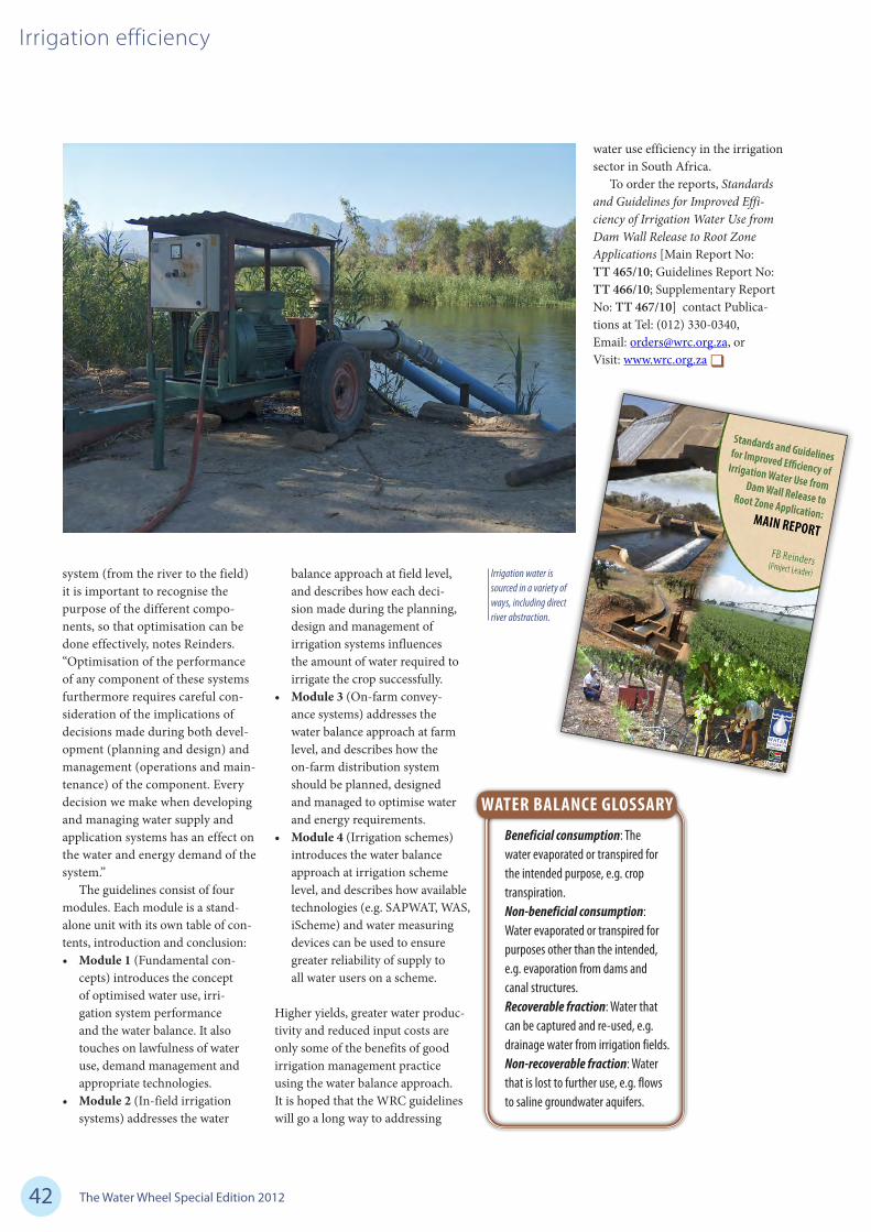
The Water Wheel Special Edition 201242
Irrigation efficiency
system (from the river to the field) it is important to recognise the purpose of the different compo-nents, so that optimisation can be done effectively, notes Reinders. “Optimisation of the performance of any component of these systems furthermore requires careful con-sideration of the implications of decisions made during both devel-opment (planning and design) and management (operations and main-tenance) of the component. Every decision we make when developing and managing water supply and application systems has an effect on the water and energy demand of the system.”
The guidelines consist of four modules. Each module is a stand-alone unit with its own table of con-tents, introduction and conclusion:• Module1 (Fundamental con-
cepts) introduces the concept of optimised water use, irri-gation system performance and the water balance. It also touches on lawfulness of water use, demand management and appropriate technologies.
• Module2 (In-field irrigation systems) addresses the water
balance approach at field level, and describes how each deci-sion made during the planning, design and management of irrigation systems influences the amount of water required to irrigate the crop successfully.
• Module3(On-farm convey-ance systems) addresses the water balance approach at farm level, and describes how the on-farm distribution system should be planned, designed and managed to optimise water and energy requirements.
• Module4(Irrigation schemes) introduces the water balance approach at irrigation scheme level, and describes how available technologies (e.g. SAPWAT, WAS, iScheme) and water measuring devices can be used to ensure greater reliability of supply to all water users on a scheme.
Higher yields, greater water produc-tivity and reduced input costs are only some of the benefits of good irrigation management practice using the water balance approach. It is hoped that the WRC guidelines will go a long way to addressing
water use efficiency in the irrigation sector in South Africa.
To order the reports, Standards and Guidelines for Improved Effi-ciency of Irrigation Water Use from Dam Wall Release to Root Zone Applications [Main Report No: TT 465/10; Guidelines Report No: TT 466/10; Supplementary Report No: TT 467/10] contact Publica-tions at Tel: (012) 330-0340, Email: [email protected], or Visit: www.wrc.org.za
Irrigation water is sourced in a variety of ways, including direct river abstraction.
WATER BALANCE GLOSSARY
Beneficial consumption:Thewaterevaporatedortranspiredfortheintendedpurpose,e.g.croptranspiration.Non-beneficial consumption:Waterevaporatedortranspiredforpurposesotherthantheintended,e.g.evaporationfromdamsandcanalstructures.Recoverable fraction:Waterthatcanbecapturedandre-used,e.g.drainagewaterfromirrigationfields.Non-recoverable fraction:Waterthatislosttofurtheruse,e.g.flowstosalinegroundwateraquifers.