Embed Size (px)
Citation preview
HAL Id: hal-03175707https://hal.archives-ouvertes.fr/hal-03175707
Submitted on 20 Mar 2021
HAL is a multi-disciplinary open accessarchive for the deposit and dissemination of sci-entific research documents, whether they are pub-lished or not. The documents may come fromteaching and research institutions in France orabroad, or from public or private research centers.
L’archive ouverte pluridisciplinaire HAL, estdestinée au dépôt et à la diffusion de documentsscientifiques de niveau recherche, publiés ou non,émanant des établissements d’enseignement et derecherche français ou étrangers, des laboratoirespublics ou privés.
SplatPlanner: Efficient Autonomous Exploration viaPermutohedral Frontier Filtering
Anthony Brunel, Amine Bourki, Cédric Demonceaux, Olivier Strauss
To cite this version:Anthony Brunel, Amine Bourki, Cédric Demonceaux, Olivier Strauss. SplatPlanner: EfficientAutonomous Exploration via Permutohedral Frontier Filtering. ICRA 2021 - 38th IEEE In-ternational Conference on Robotics and Automation, May 2021, Xi’an, China. pp.608-615,�10.1109/ICRA48506.2021.9560896�. �hal-03175707�
SplatPlanner: Efficient Autonomous Exploration
via Permutohedral Frontier Filtering
Anthony Brunel1,2, Amine Bourki2, Cedric Demonceaux3 and Olivier Strauss1
(b)
(a) (c) (d)
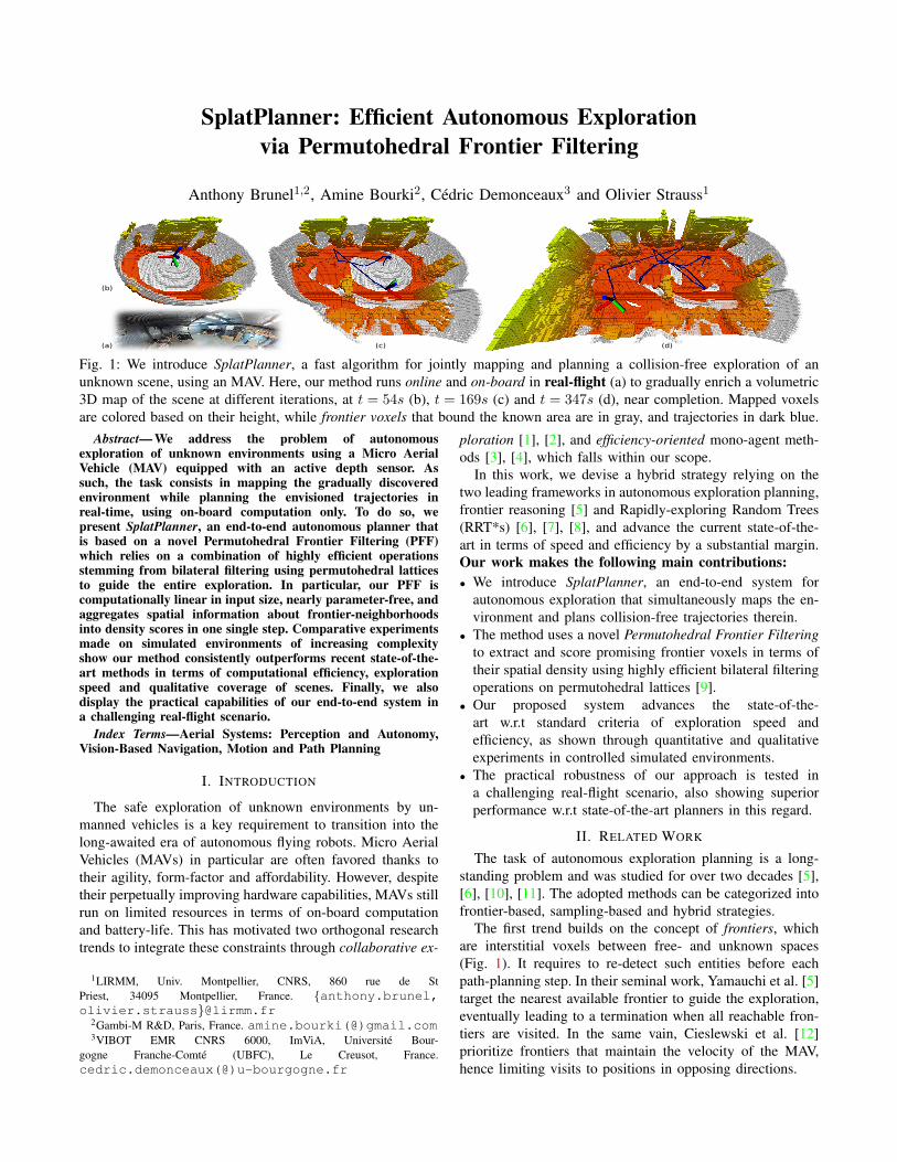
Fig. 1: We introduce SplatPlanner, a fast algorithm for jointly mapping and planning a collision-free exploration of an
unknown scene, using an MAV. Here, our method runs online and on-board in real-flight (a) to gradually enrich a volumetric
3D map of the scene at different iterations, at t = 54s (b), t = 169s (c) and t = 347s (d), near completion. Mapped voxels
are colored based on their height, while frontier voxels that bound the known area are in gray, and trajectories in dark blue.
Abstract— We address the problem of autonomousexploration of unknown environments using a Micro AerialVehicle (MAV) equipped with an active depth sensor. Assuch, the task consists in mapping the gradually discoveredenvironment while planning the envisioned trajectories inreal-time, using on-board computation only. To do so, wepresent SplatPlanner, an end-to-end autonomous planner thatis based on a novel Permutohedral Frontier Filtering (PFF)which relies on a combination of highly efficient operationsstemming from bilateral filtering using permutohedral latticesto guide the entire exploration. In particular, our PFF iscomputationally linear in input size, nearly parameter-free, andaggregates spatial information about frontier-neighborhoodsinto density scores in one single step. Comparative experimentsmade on simulated environments of increasing complexityshow our method consistently outperforms recent state-of-the-art methods in terms of computational efficiency, explorationspeed and qualitative coverage of scenes. Finally, we alsodisplay the practical capabilities of our end-to-end system ina challenging real-flight scenario.
Index Terms—Aerial Systems: Perception and Autonomy,Vision-Based Navigation, Motion and Path Planning
I. INTRODUCTION
The safe exploration of unknown environments by un-
manned vehicles is a key requirement to transition into the
long-awaited era of autonomous flying robots. Micro Aerial
Vehicles (MAVs) in particular are often favored thanks to
their agility, form-factor and affordability. However, despite
their perpetually improving hardware capabilities, MAVs still
run on limited resources in terms of on-board computation
and battery-life. This has motivated two orthogonal research
trends to integrate these constraints through collaborative ex-
1LIRMM, Univ. Montpellier, CNRS, 860 rue de St
Priest, 34095 Montpellier, France. {anthony.brunel,olivier.strauss}@lirmm.fr
2Gambi-M R&D, Paris, France. amine.bourki(@)gmail.com3VIBOT EMR CNRS 6000, ImViA, Universite Bour-
gogne Franche-Comte (UBFC), Le Creusot, France.
cedric.demonceaux(@)u-bourgogne.fr
ploration [1], [2], and efficiency-oriented mono-agent meth-
ods [3], [4], which falls within our scope.
In this work, we devise a hybrid strategy relying on the
two leading frameworks in autonomous exploration planning,
frontier reasoning [5] and Rapidly-exploring Random Trees
(RRT*s) [6], [7], [8], and advance the current state-of-the-
art in terms of speed and efficiency by a substantial margin.
Our work makes the following main contributions:
• We introduce SplatPlanner, an end-to-end system for
autonomous exploration that simultaneously maps the en-
vironment and plans collision-free trajectories therein.
• The method uses a novel Permutohedral Frontier Filtering
to extract and score promising frontier voxels in terms of
their spatial density using highly efficient bilateral filtering
operations on permutohedral lattices [9].
• Our proposed system advances the state-of-the-
art w.r.t standard criteria of exploration speed and
efficiency, as shown through quantitative and qualitative
experiments in controlled simulated environments.
• The practical robustness of our approach is tested in
a challenging real-flight scenario, also showing superior
performance w.r.t state-of-the-art planners in this regard.
II. RELATED WORK
The task of autonomous exploration planning is a long-
standing problem and was studied for over two decades [5],
[6], [10], [11]. The adopted methods can be categorized into
frontier-based, sampling-based and hybrid strategies.
The first trend builds on the concept of frontiers, which
are interstitial voxels between free- and unknown spaces
(Fig. 1). It requires to re-detect such entities before each
path-planning step. In their seminal work, Yamauchi et al. [5]
target the nearest available frontier to guide the exploration,
eventually leading to a termination when all reachable fron-
tiers are visited. In the same vain, Cieslewski et al. [12]
prioritize frontiers that maintain the velocity of the MAV,
hence limiting visits to positions in opposing directions.
Dornhege et al. [13] adhere to the broader Next-Best-View
(NBV) paradigm [14], i.e., selecting views that maximize a
specific utility function, considering the popular unmapped
volume within the current view frustum while also explicitly
grouping frontiers into cohesive entities. Even though these
two processes have become staple ingredients in frontier-
based techniques [10], they respectively rely on ray-casting
and spatial clustering operations that are computationally
expensive. Other common utility functions include the in-
formation gain [15], Shannon entropy [16], [17], supervised
learning [18], and many other efficient alternatives [19].
Sampling-based strategies on the other hand, randomly
sample seed positions in space then maintain a data structure
that can further be queried to produce a collision-free path
connecting them. Most of the recent competitive methods
rely on Rapidly-exploring Random Trees (RRTs) [6], [7].
The framework uses a tree-structure over the sampled seeds
but can produce jagged trajectories. RRTs* [8] extend RRTs
by biasing the random seed sampling to plan simpler, more
efficient trajectories. RH-NBVP [20] expands RRTs on view-
points that are sampled by means of NBV where the first
node of the utility-maximizing branch is executed. While the
method performs very well in local exploration, it is prone
to local minima leading to a poor global scene coverage.
Witting et al. [21] tackle this by maintaining a history of
previously considered viewpoints to the expense of an addi-
tional cost in computation and storage. Alternatively, AEP [3]
successfully combines RH-NBVP with conventional frontier
reasoning to balance out the poor performance in global
exploration. Although RRTs* are effective for collision-free
planning, they cannot recover from earlier mistakes. They are
also notoriously inefficient as they repeatedly discard-then-
rebuild most of the information from one iteration to another.
To improve efficiency, ESM [22] continuously grows one
single tree and only sporadically queries feasible paths.
More related to our hybrid strategy, FFI [4] uniformly
samples frontiers per octant in an octree structure [23],
then targets views that maximize the map entropy. Despite
achieving a very fast exploration, the strategy can suffer from
quantization effects and induces a trade-off between time-
and memory efficiency.
III. PROBLEM STATEMENT
Given V ⊂ R3 a voxel-grid occupancy map of the scene,
the goal of our considered MAV is to map every voxel x ∈ Vinitially labeled as ‘unknown’, with a final volumetric oc-
cupancy among {‘free’, ‘occupied’} states, while computing
collision-free flight-paths online and on-board. We denote the
pose of the MAV by µ = [p, ψ], where p = [x, y, z]⊤ ∈ R3
is a 3D position and ψ ∈ [0, 2π[ a corresponding yaw angle.
We also assume a maximum linear velocity vmax and linear
acceleration amax, as well as a maximum yaw rate ωmax.
Our framework exploits the notion of frontiers [5] which
are ‘unknown’-labeled voxels f ∈ F ⊂ V that are adjacent
to ‘free’ spaces. Our method extracts a set of filtered frontiers
F ⊂ F using scores s(pi) ⊂ S per position pi ∈ F based
on the density of their spatial neighborhoods. The MAV then
repeatedly calculates collision-free paths online, across the
scene until all reachable frontiers are visited.
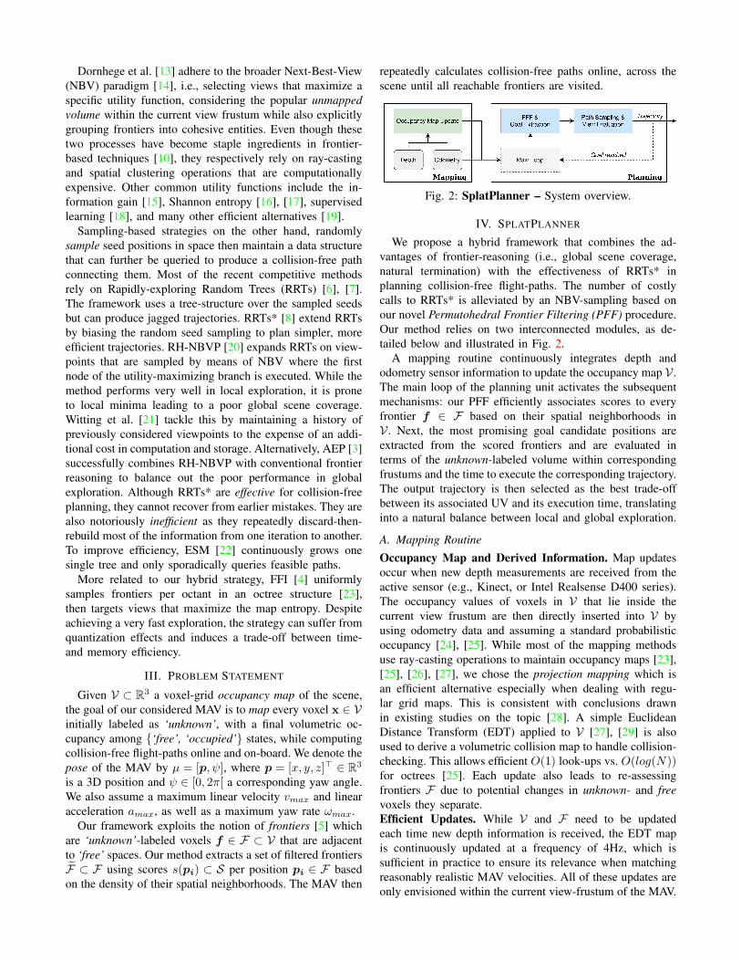
Fig. 2: SplatPlanner – System overview.
IV. SPLATPLANNER
We propose a hybrid framework that combines the ad-
vantages of frontier-reasoning (i.e., global scene coverage,
natural termination) with the effectiveness of RRTs* in
planning collision-free flight-paths. The number of costly
calls to RRTs* is alleviated by an NBV-sampling based on
our novel Permutohedral Frontier Filtering (PFF) procedure.
Our method relies on two interconnected modules, as de-
tailed below and illustrated in Fig. 2.
A mapping routine continuously integrates depth and
odometry sensor information to update the occupancy map V .
The main loop of the planning unit activates the subsequent
mechanisms: our PFF efficiently associates scores to every
frontier f ∈ F based on their spatial neighborhoods in
V . Next, the most promising goal candidate positions are
extracted from the scored frontiers and are evaluated in
terms of the unknown-labeled volume within corresponding
frustums and the time to execute the corresponding trajectory.
The output trajectory is then selected as the best trade-off
between its associated UV and its execution time, translating
into a natural balance between local and global exploration.
A. Mapping Routine
Occupancy Map and Derived Information. Map updates
occur when new depth measurements are received from the
active sensor (e.g., Kinect, or Intel Realsense D400 series).
The occupancy values of voxels in V that lie inside the
current view frustum are then directly inserted into V by
using odometry data and assuming a standard probabilistic
occupancy [24], [25]. While most of the mapping methods
use ray-casting operations to maintain occupancy maps [23],
[25], [26], [27], we chose the projection mapping which is
an efficient alternative especially when dealing with regu-
lar grid maps. This is consistent with conclusions drawn
in existing studies on the topic [28]. A simple Euclidean
Distance Transform (EDT) applied to V [27], [29] is also
used to derive a volumetric collision map to handle collision-
checking. This allows efficient O(1) look-ups vs. O(log(N))for octrees [25]. Each update also leads to re-assessing
frontiers F due to potential changes in unknown- and free
voxels they separate.
Efficient Updates. While V and F need to be updated
each time new depth information is received, the EDT map
is continuously updated at a frequency of 4Hz, which is
sufficient in practice to ensure its relevance when matching
reasonably realistic MAV velocities. All of these updates are
only envisioned within the current view-frustum of the MAV.
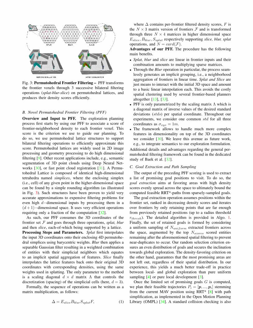
Fig. 3: Permutohedral Frontier Filtering – PFF transforms
the frontier voxels through 3 successive bilateral filtering
operations (splat-blur-slice) on permutohedral lattices, and
produces their density scores efficiently.
B. Novel Permutohedral Frontier Filtering (PFF)
Overview and Input to PFF. The exploration planning
process first starts by using our PFF to associate a score of
frontier-neighborhood density to each frontier voxel. This
score is the criterion we use to guide our planning. To
do so, we use permutohedral lattice structures to support
bilateral filtering operations to efficiently approximate this
score. Permutohedral lattices are widely used in 2D image
processing and geometry processing to do high dimensional
filtering [9]. Other recent applications include, e.g., semantic
segmentation of 3D point clouds using Deep Neural Net-
works [30], or fast point cloud registration [31]. A Permu-
tohedral Lattice is composed of identical high-dimensional
tetrahedra named simplices, where the enclosing simplex
(i.e., cell) of any given point in the higher-dimensional space
can be found by a simple rounding algorithm (as illustrated
in Fig. 3). Such structures have been proven to yield very
accurate approximations to expensive filtering problems for
even high d−dimensional inputs by processing them in a
(d+1)−dimensional space. It uses very efficient operations
requiring only a fraction of the computation [32].
As such, our PFF consumes the 3D coordinates of the
frontier set F and goes through three operations, splat, blur
and then slice, each-of-which being supported by a lattice.
Processing Steps and Parameters. Splat first interpolates
the input 3D coordinates onto their enclosing 4D permutohe-
dral simplices using barycentric weights. Blur then applies a
separable Gaussian filter resulting in a weighted combination
of entities with their simplicial neighbors which equates
to an implicit spatial aggregation of features. Slice finally
interpolates the lattice features back onto their original 3D
coordinates with corresponding densities, using the same
weights used in splatting. The only parameter to the method
is a scaling diagonal d × d matrix Λ that controls the
discretization (spacing) of the simplicial cells (here, d = 3).
Formally, the sequence of operations can be written as a
matrix multiplication, as follows:
∆ = EsliceBblurSsplatF, (1)
where ∆ contains per-frontier filtered density scores, F is
the N × 3 matrix version of frontiers F and is transformed
through three N × 4 matrices in higher dimensional space
Eslice, Bblur, Ssplat respectively supporting slice, blur, splat
operations, and N = card(F).Advantages of our PFF. The procedure has the following
main benefits.
• Splat, blur and slice are linear in frontier inputs and their
combination amounts to multiplying sparse matrices.
• Through the Blur operation in particular, the process seam-
lessly generates an implicit grouping, i.e., a neighborhood
aggregation of frontiers in linear time. Splat and Slice are
just means to interact with the initial 3D space and amount
to a basic linear interpolation each. This avoids the costly
spatial clustering used by several frontier-based planners
altogether [13], [33].
• PFF is only parametrized by the scaling matrix Λ which is
a diagonal matrix of inverse values of the desired standard
deviations (stds) per spatial coordinate. Throughout our
experiments, we consider one common std for all three
coordinates as σxyz = 1m.
• The framework allows to handle much more complex
features in dimensionality on top of the 3D coordinates
we consider [30]. We leave this avenue as future work,
e.g., to integrate semantics to our exploration formulation.
Additional details and advantages regarding the general per-
mutohedral filtering framework can be found in the dedicated
study of Baek et al. [32].
C. Goal Extraction and Path Sampling
The output of the preceding PFF scoring is used to extract
a list of promising goal positions to visit. To do so, the
goal extraction aims at favoring areas with high density
scores evenly spread across the space to ultimately bound the
computed feasible RRT*-paths from sparsely-sampled goals.
The goal extraction operation assumes positions within the
frontier set, ranked in decreasing density scores and iterates
over frontiers by only retaining points that are far enough
from previously retained positions (up to a radius threshold
rthresh). The detailed algorithm is provided in Algo. 1.
Finally, the set of retained goals is formed by considering
a uniform sampling of Nuniform extracted frontiers across
the space, augmented by the top Nscores scored entities
remaining after the aforementioned spatial filtering to prevent
near-duplicates to occur. Our random selection criterion en-
sures an even distribution of goals and secures the inclination
towards global exploration. The density-favoring criterion on
the other hand, guarantees that the most promising areas are
not left out, regardless of their spatial distribution. In our
experience, this yields a much better trade-off in practice
between local- and global exploration than pure uniform
sampling [4] or pure local development [3].
Once the limited set of promising goals G is computed,
we plan their feasible trajectories Pi = [p, ...,pi] stemming
from the current MAV position using RRT* [8] with path
simplification, as implemented in the Open Motion Planning
Library (OMPL) [34]. A standard collision checking is also

Algorithm 1: Goal Candidate Extraction
Input: P : list of position / score pairs (pi, si) in
decreasing scores, rthresh : radius threshold
Output: G : set of goal candidates
foreach position pi ∈ P do
discarded← False;foreach pj ∈ G do
if ‖pi − pj‖ < rthresh then
discarded← True;break;
end
end
if not discarded thenG← (pi, si)
end
end
applied throughout the linear segments of the computed paths
with a safety bounding radius R centered on the MAV. An
occlusion checking by casting a ray from the current position
to the goal candidates ensures mutual visibility between end-
points. An additional time-out forces the RRT* to provide
viable solutions within a limited time (set to 5 ms), for
maintaining the overall pace of the exploration.
D. Viewpoint Evaluation, Yaw Angles and Gain Function
At this stage, the promising goals resulting from previous
steps are guaranteed by construction to be valid and reach-
able. Next, we describe how we prioritize the exploration
to maximize its efficiency by evaluating the volumetric gain
relative to the time it costs to execute the associated trajecto-
ries. This consists in estimating through ray-casting the view-
dependent Unmapped Volume (UV) intersecting the frustum
bounded between distances to the camera center dmin and
dmax. α (resp. β) is the horizontal (resp. vertical) angular
increment used in ray-casting (typically, α = β = 1◦). Thus,
a 360◦ horizontal UV-sweep produces a view-independent
estimate of the volume assuming a fixed (sensor-specific)
vertical fov, as follows:
V (dmin, dmax, α, β) = 4 tan (α
2) tan (
β
2)
∫ dmax
dmin
r2dr
=4
3tan (
α
2) tan (
β
2)(d3max − d
3
min)
(2)
Yaw Optimization. Yaw values ψi are associated to the
positions pi encompassing goal candidates and intermediate
waypoints alike, by retaining the horizontal orientation that
maximizes its view-dependent UV within the computation of
the volume. Please note that the optimal yaws are retained
while calculating the volume with no additional post-process.
Gain Function. Finally, the gain function explicitly opti-
mizes the volumetric exploration speed in m3/s, to execute
the path Pi that maximizes the following expression:
g(µi, Pi) =U(µi)
T (Pi), (3)
TABLE I: Experimental settings and parameters.
Method Parameter MAZE POWERPLANT FACILITY
All
res. (m) 0.1 0.2 0.1R (m) 0.5 0.5 0.5vmax (m/s) 1.5 0.7, 1.5, 2.5 1.5amax (m/s2) 2.5 2.5 2.5ωmax (rad/s) 1.57 0.75, 1.57 1.57dmax (m) 5 7 5fov [h, v] [90◦, 60◦] [115◦, 60◦] [90◦, 75◦]
Oursrthresh (m) 2.5 2.5 2.5σxyz (m) 1.0 1.0 1.0
AEP [3]
N 30 50 30gzero 2 2 2λ 0.5 0.75 0.5σ2
tresh0.2 0.2 0.2
lmax (m) 1.5 3 1.5
ESM [22]
nlocal 30 50 30rlocal (m) 1.5 3.0 1.5rupdate (m) 3. 6. 3.0lmax (m) 1.5 3 1.5
where U(µi) is the UV of the destination pose at position pi
and Pi its connecting path to current MAV position p with
pose µ. In turn, T (Pi) is the total travel time to execute Pi
assuming a constant acceleration amax.
V. IMPLEMENTATION DETAILS
Simulation Framework. Except where stated otherwise,
throughout our experiments we consider a common testbed
built on the Robot Operating System (ROS Kinetic) li-
brary [35] on a laptop equipped with an Intel Core i7 CPU,
16GB RAM. We simulate a FireFly hexacopter MAV model
from Ascending Technologies and its physics are modeled
by the popular Gazebo-based RotorS simulator [36]. The
control is insured by a multi-rotor Model Predictive Control
(MPC) [37]. Standard collision-checking is done within a
sphere of radius R centered at the MAV’s position. As the
computed trajectories are typically piecewise-linear displace-
ments, we use a polynomial trajectory optimization [38]
to send graceful paths to the MPC. The final rendering
uses the Vulkan API1, assuming perfect poses from RotorS.
It simulates a 30Hz DepthVision camera. All considered
datasets were integrated as standard meshes into Gazebo.
Parameter Settings and Reproducibility. The parameters
to all our experiments are provided in Table I, including ones
that were originally omitted by the referenced competition.
VI. RESULTS
In this section, we analyze the performance of our Splat-
Planner system and its relative positioning w.r.t the state-of-
the-art through quantitative and qualitative experiments.
A. Datasets and Baselines
In our comparative experiments, we consider the recent
state-of-the-art planners ESM [22], AEP [3] and FFI [4].
ESM is the current top-performing pure sampling-based
method [22] while AEP and FFI are among the best hybrid
systems for autonomous exploration.
We first consider 3 challenging synthetic datasets of in-
creasing complexity and size.
1https://www.khronos.org/vulkan/
0 500 1000 15000
0.5
1
1.5
2
·104
Time (s)
Explo
red
volu
me
(m3)
vmax = 2.5 m/s
vmax = 1.5 m/s
vmax = 0.7 m/s
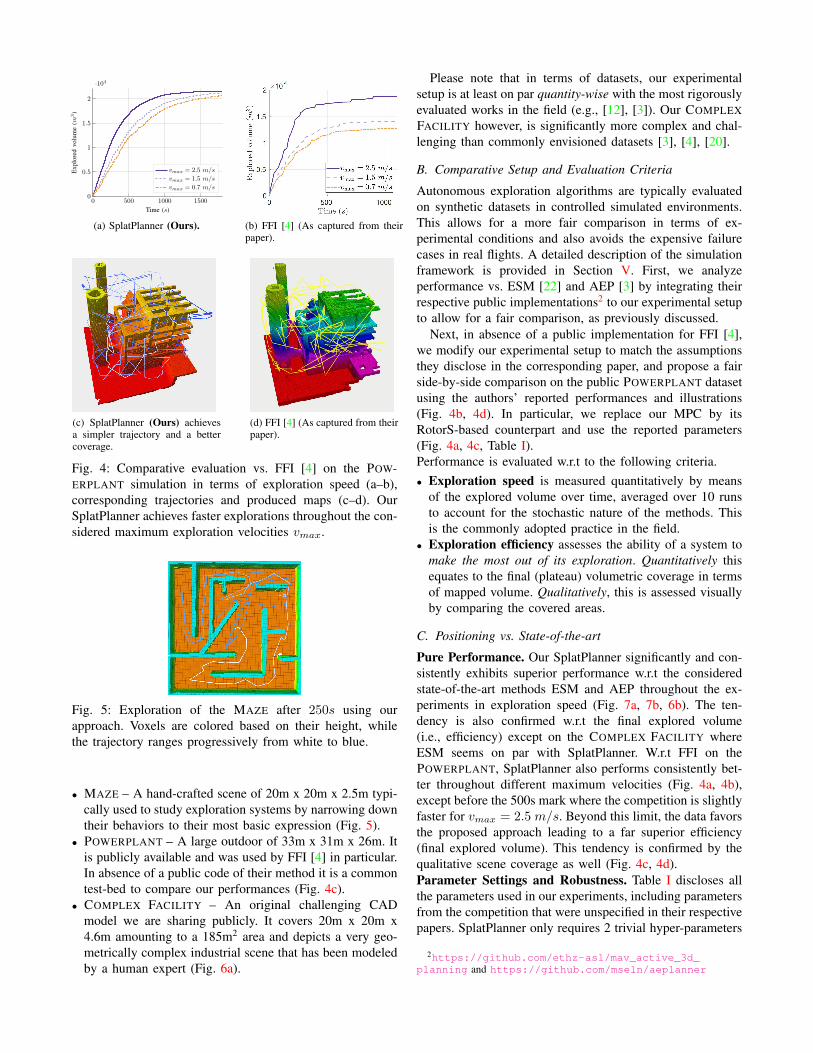
(a) SplatPlanner (Ours). (b) FFI [4] (As captured from theirpaper).
(c) SplatPlanner (Ours) achievesa simpler trajectory and a bettercoverage.
(d) FFI [4] (As captured from theirpaper).
Fig. 4: Comparative evaluation vs. FFI [4] on the POW-
ERPLANT simulation in terms of exploration speed (a–b),
corresponding trajectories and produced maps (c–d). Our
SplatPlanner achieves faster explorations throughout the con-
sidered maximum exploration velocities vmax.
Fig. 5: Exploration of the MAZE after 250s using our
approach. Voxels are colored based on their height, while
the trajectory ranges progressively from white to blue.
• MAZE – A hand-crafted scene of 20m x 20m x 2.5m typi-
cally used to study exploration systems by narrowing down
their behaviors to their most basic expression (Fig. 5).
• POWERPLANT – A large outdoor of 33m x 31m x 26m. It
is publicly available and was used by FFI [4] in particular.
In absence of a public code of their method it is a common
test-bed to compare our performances (Fig. 4c).
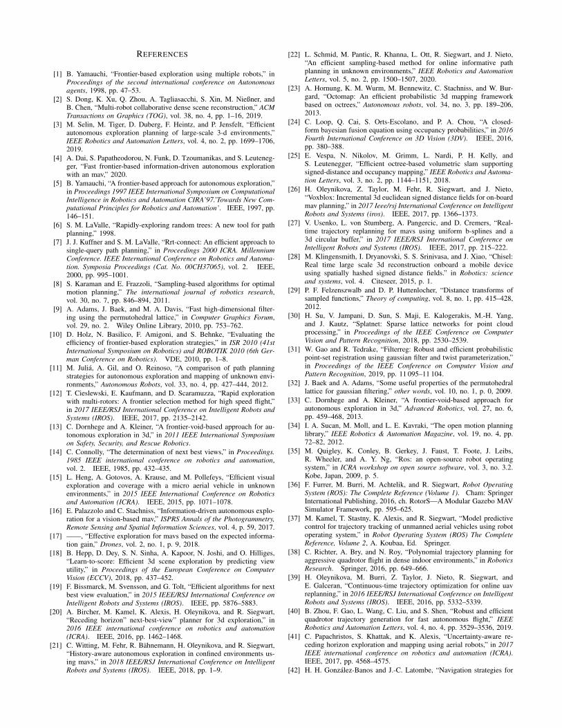
• COMPLEX FACILITY – An original challenging CAD
model we are sharing publicly. It covers 20m x 20m x
4.6m amounting to a 185m2 area and depicts a very geo-
metrically complex industrial scene that has been modeled
by a human expert (Fig. 6a).
Please note that in terms of datasets, our experimental
setup is at least on par quantity-wise with the most rigorously
evaluated works in the field (e.g., [12], [3]). Our COMPLEX
FACILITY however, is significantly more complex and chal-
lenging than commonly envisioned datasets [3], [4], [20].
B. Comparative Setup and Evaluation Criteria
Autonomous exploration algorithms are typically evaluated
on synthetic datasets in controlled simulated environments.
This allows for a more fair comparison in terms of ex-
perimental conditions and also avoids the expensive failure
cases in real flights. A detailed description of the simulation
framework is provided in Section V. First, we analyze
performance vs. ESM [22] and AEP [3] by integrating their
respective public implementations2 to our experimental setup
to allow for a fair comparison, as previously discussed.
Next, in absence of a public implementation for FFI [4],
we modify our experimental setup to match the assumptions
they disclose in the corresponding paper, and propose a fair
side-by-side comparison on the public POWERPLANT dataset
using the authors’ reported performances and illustrations
(Fig. 4b, 4d). In particular, we replace our MPC by its
RotorS-based counterpart and use the reported parameters
(Fig. 4a, 4c, Table I).
Performance is evaluated w.r.t to the following criteria.
• Exploration speed is measured quantitatively by means
of the explored volume over time, averaged over 10 runs
to account for the stochastic nature of the methods. This
is the commonly adopted practice in the field.
• Exploration efficiency assesses the ability of a system to
make the most out of its exploration. Quantitatively this
equates to the final (plateau) volumetric coverage in terms
of mapped volume. Qualitatively, this is assessed visually
by comparing the covered areas.
C. Positioning vs. State-of-the-art
Pure Performance. Our SplatPlanner significantly and con-
sistently exhibits superior performance w.r.t the considered
state-of-the-art methods ESM and AEP throughout the ex-
periments in exploration speed (Fig. 7a, 7b, 6b). The ten-
dency is also confirmed w.r.t the final explored volume
(i.e., efficiency) except on the COMPLEX FACILITY where
ESM seems on par with SplatPlanner. W.r.t FFI on the
POWERPLANT, SplatPlanner also performs consistently bet-
ter throughout different maximum velocities (Fig. 4a, 4b),
except before the 500s mark where the competition is slightly
faster for vmax = 2.5m/s. Beyond this limit, the data favors
the proposed approach leading to a far superior efficiency
(final explored volume). This tendency is confirmed by the
qualitative scene coverage as well (Fig. 4c, 4d).
Parameter Settings and Robustness. Table I discloses all
the parameters used in our experiments, including parameters
from the competition that were unspecified in their respective
papers. SplatPlanner only requires 2 trivial hyper-parameters
2https://github.com/ethz-asl/mav_active_3d_
planning and https://github.com/mseln/aeplanner
(a) CAD Input.
SplatPlanner (Ours) AEP [3] ESM [22]
(b) Qualitative comparison of the maps produced at t = 300s. Voxels are colored based on their height.
Fig. 6: COMPLEX FACILITY – Our SplatPlanner explores this complex environment more efficiently and better retrieves
complex geometric details w.r.t the state-of-the-art competition.
0 200 400 600 8000
200
400
600
800
1000
Time (s)
Explo
red
volu
me
(m3)
AEP [3]
ESM [22]
Ours
(a) MAZE
0 500 1000 15000
0.5
1
1.5
2
·104
Time (s)
Explo
red
volu
me
(m3)
AEP [3]
ESM [22]
Ours
(b) POWERPLANT
0 200 400 600 8000
500
1000
1500
Time (s)
Explo
red
volu
me
(m3)
AEP [3]
ESM [22]
Ours
(c) COMPLEX FACILITY
Fig. 7: Exploration speeds averaged over 10 runs.
(vs. 5–6) that remain stable on all scenes. This supports the
superior robustness of SplatPlanner w.r.t state-of-the-art in
this aspect as well.
Additional Insights. Table II shows comparative exploration
planning statistics w.r.t state-of-the-art. Our method requires
much fewer, but slower planning iterations. Yet, it develops
faster, into a much longer path overall.
TABLE II: COMPLEX FACILITY – Statistics after 300s.
Method #Iterations Per-iter. avg time (ms) Path length (m)
Ours 48 280± 34 157
AEP [3] 90 54± 25 124ESM [22] 128 N/A 128
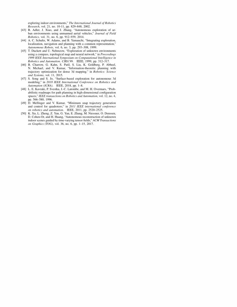
Fig. 8: SplatPlanner runs online and on-board from take-
off to termination with no human intervention nor prior
knowledge about this large 15m x 10m x 3.5m WAREHOUSE.
D. Real-Flight Performance
We evaluate the practical robustness of our end-to-end
system on a challenging fully-autonomous flight (Fig. 8).
Our custom MAV flies through a large WAREHOUSE that
is bound at 15m x 10m x 3.5m and runs our SplatPlanner
algorithm online and on-board during 349s. The results of
this experiment are depicted step by step in Fig. 1 and are the
direct output of on-board processing. In comparison to real-
flight experiments provided by top-performing planners [3],
[4], ours takes place in a significantly more complex, larger
indoor environment than the ones referenced. This represents
an improvement in volumetric size of the considered scenes
ranging from 2.75x [4] to 4.66x [3] over the leading competi-
tion. In terms of hardware, the MAV we consider is a custom
quadrotor using a DJI A3 flight controller. The equipped
sensors include an Intel T265 VI-SLAM for odometry, a
D455 depth VGA camera and an Intel NUC with an Intel
Core i7-10710U and 16GB of memory.
Additional detailed information about the real-flight and
simulation experiments are provided in a supplementary
video at https://youtu.be/DCcfA2HB1GI.
VII. CONCLUSION
We have presented SplatPlanner, an end-to-end au-
tonomous system for 3D exploration planning in unknown
environments using an MAV equipped with a depth sensor.
The proposed method improves over recent state-of-the-
art methods in terms of exploration efficiency and speed,
as consistently supported by the considered simulation ex-
periments. An additional real-flight scenario also underlines
the practical robustness of our global solution.
As future work, we plan on integrating semantic reasoning
into our formulation by leveraging the pose and volumetric
occupancy of detected objects of interest.
REFERENCES
[1] B. Yamauchi, “Frontier-based exploration using multiple robots,” inProceedings of the second international conference on Autonomous
agents, 1998, pp. 47–53.
[2] S. Dong, K. Xu, Q. Zhou, A. Tagliasacchi, S. Xin, M. Nießner, andB. Chen, “Multi-robot collaborative dense scene reconstruction,” ACM
Transactions on Graphics (TOG), vol. 38, no. 4, pp. 1–16, 2019.
[3] M. Selin, M. Tiger, D. Duberg, F. Heintz, and P. Jensfelt, “Efficientautonomous exploration planning of large-scale 3-d environments,”IEEE Robotics and Automation Letters, vol. 4, no. 2, pp. 1699–1706,2019.
[4] A. Dai, S. Papatheodorou, N. Funk, D. Tzoumanikas, and S. Leuteneg-ger, “Fast frontier-based information-driven autonomous explorationwith an mav,” 2020.
[5] B. Yamauchi, “A frontier-based approach for autonomous exploration,”in Proceedings 1997 IEEE International Symposium on Computational
Intelligence in Robotics and Automation CIRA’97.’Towards New Com-
putational Principles for Robotics and Automation’. IEEE, 1997, pp.146–151.
[6] S. M. LaValle, “Rapidly-exploring random trees: A new tool for pathplanning,” 1998.
[7] J. J. Kuffner and S. M. LaValle, “Rrt-connect: An efficient approach tosingle-query path planning,” in Proceedings 2000 ICRA. Millennium
Conference. IEEE International Conference on Robotics and Automa-
tion. Symposia Proceedings (Cat. No. 00CH37065), vol. 2. IEEE,2000, pp. 995–1001.
[8] S. Karaman and E. Frazzoli, “Sampling-based algorithms for optimalmotion planning,” The international journal of robotics research,vol. 30, no. 7, pp. 846–894, 2011.
[9] A. Adams, J. Baek, and M. A. Davis, “Fast high-dimensional filter-ing using the permutohedral lattice,” in Computer Graphics Forum,vol. 29, no. 2. Wiley Online Library, 2010, pp. 753–762.
[10] D. Holz, N. Basilico, F. Amigoni, and S. Behnke, “Evaluating theefficiency of frontier-based exploration strategies,” in ISR 2010 (41st
International Symposium on Robotics) and ROBOTIK 2010 (6th Ger-
man Conference on Robotics). VDE, 2010, pp. 1–8.
[11] M. Julia, A. Gil, and O. Reinoso, “A comparison of path planningstrategies for autonomous exploration and mapping of unknown envi-ronments,” Autonomous Robots, vol. 33, no. 4, pp. 427–444, 2012.
[12] T. Cieslewski, E. Kaufmann, and D. Scaramuzza, “Rapid explorationwith multi-rotors: A frontier selection method for high speed flight,”in 2017 IEEE/RSJ International Conference on Intelligent Robots and
Systems (IROS). IEEE, 2017, pp. 2135–2142.
[13] C. Dornhege and A. Kleiner, “A frontier-void-based approach for au-tonomous exploration in 3d,” in 2011 IEEE International Symposium
on Safety, Security, and Rescue Robotics.
[14] C. Connolly, “The determination of next best views,” in Proceedings.
1985 IEEE international conference on robotics and automation,vol. 2. IEEE, 1985, pp. 432–435.
[15] L. Heng, A. Gotovos, A. Krause, and M. Pollefeys, “Efficient visualexploration and coverage with a micro aerial vehicle in unknownenvironments,” in 2015 IEEE International Conference on Robotics
and Automation (ICRA). IEEE, 2015, pp. 1071–1078.
[16] E. Palazzolo and C. Stachniss, “Information-driven autonomous explo-ration for a vision-based mav,” ISPRS Annals of the Photogrammetry,
Remote Sensing and Spatial Information Sciences, vol. 4, p. 59, 2017.
[17] ——, “Effective exploration for mavs based on the expected informa-tion gain,” Drones, vol. 2, no. 1, p. 9, 2018.
[18] B. Hepp, D. Dey, S. N. Sinha, A. Kapoor, N. Joshi, and O. Hilliges,“Learn-to-score: Efficient 3d scene exploration by predicting viewutility,” in Proceedings of the European Conference on Computer
Vision (ECCV), 2018, pp. 437–452.
[19] F. Bissmarck, M. Svensson, and G. Tolt, “Efficient algorithms for nextbest view evaluation,” in 2015 IEEE/RSJ International Conference on
Intelligent Robots and Systems (IROS). IEEE, pp. 5876–5883.
[20] A. Bircher, M. Kamel, K. Alexis, H. Oleynikova, and R. Siegwart,“Receding horizon” next-best-view” planner for 3d exploration,” in2016 IEEE international conference on robotics and automation
(ICRA). IEEE, 2016, pp. 1462–1468.
[21] C. Witting, M. Fehr, R. Bahnemann, H. Oleynikova, and R. Siegwart,“History-aware autonomous exploration in confined environments us-ing mavs,” in 2018 IEEE/RSJ International Conference on Intelligent
Robots and Systems (IROS). IEEE, 2018, pp. 1–9.
[22] L. Schmid, M. Pantic, R. Khanna, L. Ott, R. Siegwart, and J. Nieto,“An efficient sampling-based method for online informative pathplanning in unknown environments,” IEEE Robotics and Automation
Letters, vol. 5, no. 2, pp. 1500–1507, 2020.
[23] A. Hornung, K. M. Wurm, M. Bennewitz, C. Stachniss, and W. Bur-gard, “Octomap: An efficient probabilistic 3d mapping frameworkbased on octrees,” Autonomous robots, vol. 34, no. 3, pp. 189–206,2013.
[24] C. Loop, Q. Cai, S. Orts-Escolano, and P. A. Chou, “A closed-form bayesian fusion equation using occupancy probabilities,” in 2016
Fourth International Conference on 3D Vision (3DV). IEEE, 2016,pp. 380–388.
[25] E. Vespa, N. Nikolov, M. Grimm, L. Nardi, P. H. Kelly, andS. Leutenegger, “Efficient octree-based volumetric slam supportingsigned-distance and occupancy mapping,” IEEE Robotics and Automa-
tion Letters, vol. 3, no. 2, pp. 1144–1151, 2018.
[26] H. Oleynikova, Z. Taylor, M. Fehr, R. Siegwart, and J. Nieto,“Voxblox: Incremental 3d euclidean signed distance fields for on-boardmav planning,” in 2017 Ieee/rsj International Conference on Intelligent
Robots and Systems (iros). IEEE, 2017, pp. 1366–1373.
[27] V. Usenko, L. von Stumberg, A. Pangercic, and D. Cremers, “Real-time trajectory replanning for mavs using uniform b-splines and a3d circular buffer,” in 2017 IEEE/RSJ International Conference on
Intelligent Robots and Systems (IROS). IEEE, 2017, pp. 215–222.
[28] M. Klingensmith, I. Dryanovski, S. S. Srinivasa, and J. Xiao, “Chisel:Real time large scale 3d reconstruction onboard a mobile deviceusing spatially hashed signed distance fields.” in Robotics: science
and systems, vol. 4. Citeseer, 2015, p. 1.
[29] P. F. Felzenszwalb and D. P. Huttenlocher, “Distance transforms ofsampled functions,” Theory of computing, vol. 8, no. 1, pp. 415–428,2012.
[30] H. Su, V. Jampani, D. Sun, S. Maji, E. Kalogerakis, M.-H. Yang,and J. Kautz, “Splatnet: Sparse lattice networks for point cloudprocessing,” in Proceedings of the IEEE Conference on Computer
Vision and Pattern Recognition, 2018, pp. 2530–2539.
[31] W. Gao and R. Tedrake, “Filterreg: Robust and efficient probabilisticpoint-set registration using gaussian filter and twist parameterization,”in Proceedings of the IEEE Conference on Computer Vision and
Pattern Recognition, 2019, pp. 11 095–11 104.
[32] J. Baek and A. Adams, “Some useful properties of the permutohedrallattice for gaussian filtering,” other words, vol. 10, no. 1, p. 0, 2009.
[33] C. Dornhege and A. Kleiner, “A frontier-void-based approach forautonomous exploration in 3d,” Advanced Robotics, vol. 27, no. 6,pp. 459–468, 2013.
[34] I. A. Sucan, M. Moll, and L. E. Kavraki, “The open motion planninglibrary,” IEEE Robotics & Automation Magazine, vol. 19, no. 4, pp.72–82, 2012.
[35] M. Quigley, K. Conley, B. Gerkey, J. Faust, T. Foote, J. Leibs,R. Wheeler, and A. Y. Ng, “Ros: an open-source robot operatingsystem,” in ICRA workshop on open source software, vol. 3, no. 3.2.Kobe, Japan, 2009, p. 5.
[36] F. Furrer, M. Burri, M. Achtelik, and R. Siegwart, Robot Operating
System (ROS): The Complete Reference (Volume 1). Cham: SpringerInternational Publishing, 2016, ch. RotorS—A Modular Gazebo MAVSimulator Framework, pp. 595–625.
[37] M. Kamel, T. Stastny, K. Alexis, and R. Siegwart, “Model predictivecontrol for trajectory tracking of unmanned aerial vehicles using robotoperating system,” in Robot Operating System (ROS) The Complete
Reference, Volume 2, A. Koubaa, Ed. Springer.
[38] C. Richter, A. Bry, and N. Roy, “Polynomial trajectory planning foraggressive quadrotor flight in dense indoor environments,” in Robotics
Research. Springer, 2016, pp. 649–666.
[39] H. Oleynikova, M. Burri, Z. Taylor, J. Nieto, R. Siegwart, andE. Galceran, “Continuous-time trajectory optimization for online uavreplanning,” in 2016 IEEE/RSJ International Conference on Intelligent
Robots and Systems (IROS). IEEE, 2016, pp. 5332–5339.
[40] B. Zhou, F. Gao, L. Wang, C. Liu, and S. Shen, “Robust and efficientquadrotor trajectory generation for fast autonomous flight,” IEEE
Robotics and Automation Letters, vol. 4, no. 4, pp. 3529–3536, 2019.
[41] C. Papachristos, S. Khattak, and K. Alexis, “Uncertainty-aware re-ceding horizon exploration and mapping using aerial robots,” in 2017
IEEE international conference on robotics and automation (ICRA).IEEE, 2017, pp. 4568–4575.
[42] H. H. Gonzalez-Banos and J.-C. Latombe, “Navigation strategies for
exploring indoor environments,” The International Journal of Robotics
Research, vol. 21, no. 10-11, pp. 829–848, 2002.[43] B. Adler, J. Xiao, and J. Zhang, “Autonomous exploration of ur-
ban environments using unmanned aerial vehicles,” Journal of Field
Robotics, vol. 31, no. 6, pp. 912–939, 2014.[44] A. C. Schultz, W. Adams, and B. Yamauchi, “Integrating exploration,
localization, navigation and planning with a common representation,”Autonomous Robots, vol. 6, no. 3, pp. 293–308, 1999.
[45] T. Duckett and U. Nehmzow, “Exploration of unknown environmentsusing a compass, topological map and neural network,” in Proceedings
1999 IEEE International Symposium on Computational Intelligence in
Robotics and Automation. CIRA’99. IEEE, 1999, pp. 312–317.[46] B. Charrow, G. Kahn, S. Patil, S. Liu, K. Goldberg, P. Abbeel,
N. Michael, and V. Kumar, “Information-theoretic planning withtrajectory optimization for dense 3d mapping.” in Robotics: Science
and Systems, vol. 11, 2015.[47] S. Song and S. Jo, “Surface-based exploration for autonomous 3d
modeling,” in 2018 IEEE International Conference on Robotics and
Automation (ICRA). IEEE, 2018, pp. 1–8.[48] L. E. Kavraki, P. Svestka, J.-C. Latombe, and M. H. Overmars, “Prob-
abilistic roadmaps for path planning in high-dimensional configurationspaces,” IEEE transactions on Robotics and Automation, vol. 12, no. 4,pp. 566–580, 1996.
[49] D. Mellinger and V. Kumar, “Minimum snap trajectory generationand control for quadrotors,” in 2011 IEEE international conference
on robotics and automation. IEEE, 2011, pp. 2520–2525.[50] K. Xu, L. Zheng, Z. Yan, G. Yan, E. Zhang, M. Niessner, O. Deussen,
D. Cohen-Or, and H. Huang, “Autonomous reconstruction of unknownindoor scenes guided by time-varying tensor fields,” ACM Transactions
on Graphics (TOG), vol. 36, no. 6, pp. 1–15, 2017.