Embed Size (px)
Citation preview

Springsure Creek Agricultural Co-existence Research Committee (ACRC)
Draft Co-existence Research Plan
2013 – 2016
Title Reviewer Review Date Version Version Controller
ACRC Research Plan D Hamilton 13 June 2013 11.1 Rachel Gibson
DNRM - RTI D
L RELE
ASE
13-310 DL Documents Page 1 of 62

SPRINGSURE CREEK AGRICULTURAL PROJECT DRAFT CO-EXISTENCE RESEARCH PLAN
13-Jun-13 P a g e | i
TABLE OF CONTENTS
Executive Summary ................................................................................................................................. 1
1.0 introduction .................................................................................................................................. 2
1.1 Background ......................................................................................................................... 2
1.2 Review and feedback on Draft Co-existence Research Plan .............................................. 2
1.3 Location .............................................................................................................................. 2
1.4 Commissioning the research .............................................................................................. 2
2.0 Potential impacts of long wall mining and key research objectives ............................................. 4
2.1 Potential impacts on natural resources and agricultural productivity ............................... 4
2.2 Potential impacts on farming systems and logistics .......................................................... 5
2.3 Understanding community expectations and maximising the benefits of mining investment .................................................................................................................................... 6
3.0 Research Framework and Investment .......................................................................................... 7
3.1 Research Area 1 - Benchmarking productivity ................................................................... 7
3.2 Research Area 2 - Assessing and managing biophysical impacts ....................................... 7
3.3 Research Area 3 - Developing effective farming systems .................................................. 8
3.4 Research Area 4 - Understanding community expectations and maximising investment benefits ......................................................................................................................................... 8
4.0 Research Project Activity Outlines .............................................................................................. 11
4.1 Research Area 1 - Benchmarking productivity ................................................................. 11
4.2 Research Area 2 - Assessing and managing biophysical impacts ..................................... 13
4.3 Research Area 3 - Developing effective farming systems ................................................ 19
4.4 Research Area 4 - Understanding community expectations and maximising investment benefits ....................................................................................................................................... 21
5.0 Communication .......................................................................................................................... 22
6.0 Challenges of cropping in the Central Highlands of Queensland ............................................... 23
6.1 Water supply and temperature ........................................................................................ 23
6.2 Nutrient supply ................................................................................................................. 25
6.3 Soil type and depth and capacity to store Plant Available Water .................................... 25
6.4 Erosion risk associated with rainfall intensity and seasonality and management of soil cover 25
6.5 Economic viability ............................................................................................................. 26
7.0 Challenges in assessing productivity .......................................................................................... 27
8.0 References .................................................................................................................................. 28
DNRM - RTI D
L RELE
ASE
13-310 DL Documents Page 2 of 62

SPRINGSURE CREEK AGRICULTURAL PROJECT DRAFT CO-EXISTENCE RESEARCH PLAN
13-Jun-13 P a g e | ii
Appendices
Appendix A - Longwall Mining at Springsure Creek Coal Mine
Longwall mining technique ............................................................................................................ A-2
How subsidence occurs after longwall mining .............................................................................. A-3
Predicted subsidence ..................................................................................................................... A-4
List of Figures
Figure 1: Location of the proposed Springsure Creek Coal Mine ........................................................... 3
Figure 2: A conceptual diagram of landscape changes associated with longwall mining ...................... 4
Figure 3: A conceptual diagram of possible changes in contour banks associated with subsidence .... 5
Figure 4: Annual rainfall at “Acturus Downs” Springsure, Qld ............................................................. 24
Figure 5: A sample of daily maximum temperature at Emerald, Qld ................................................... 24
Figure 6: Soil Organic Carbon since cultivation, lower Condamine...................................................... 25
Figure 7: Relationship between soil loss and soil cover for five soil management conditions ............ 26
List of Tables
Table 1: Summary of proposed research investment ........................................................................... 10
Table 2: Project 1 – Benchmarking productivity ................................................................................... 11
Table 3: Project 2.1 - Assessing the impact of subsidence on soil properties and the soil-water balance ..................................................................................................................................... 13
Table 4: Project 2.2 – Assessing and managing erosion risk ................................................................. 14
Table 5: Project 2.3 – Managing drainage and ponding with subsidence ............................................. 16
Table 6: Project 2.4 – Assessing local sub-catchment impacts on water .............................................. 17
Table 7: Project 3.1 – Assessing and managing the impact of subsidence on farm logistics ................ 19
Table 8: Project 4.1 – Understanding community expectations and maximising investment benefits 21
DNRM - RTI D
L RELE
ASE
13-310 DL Documents Page 3 of 62

SPRINGSURE CREEK AGRICULTURAL PROJECT DRAFT CO-EXISTENCE RESEARCH PLAN
13-Jun-13 P a g e | iii
Springsure Creek Agricultural Coexistence Research Committee
The purpose of the Springsure Creek Agricultural Coexistence Research Committee is to guide the Coexistence Research program in the following:
• Setting the research framework, questions and program; • Developing criteria for selecting research providers; • Receiving quarterly updates (progress reports/results) from the researchers; • Providing guidance of research (advice on any research issues); • Timing of research; and • Disseminating research findings to relevant stakeholders.
Members of the Committee:
• David Hamilton – Hamilton Agriculture (Current Chairman) • Professor Steven Raine – Deputy Dean and Associate Dean (Academic) within the Faculty
of Engineering and Surveying at University of Southern Queensland; • Professor Helen Ross (and Associate Professor Jim Cavaye while Helen Ross is on
sabbatical leave) – School of Agriculture and Food Science University of Queensland; • Dr David Freebairn, Soil Scientist, Principal Environmental Scientist, RPS Australia East
Pty Ltd • Professor Robert Darmody, Professor of Soil Science, University of Illinois at Urbana-
Champaign • Representative from Agforce (to be nominated);
DNRM - RTI D
L RELE
ASE
13-310 DL Documents Page 4 of 62

SPRINGSURE CREEK AGRICULTURAL PROJECT DRAFT CO-EXISTENCE RESEARCH PLAN
13-Jun-13 P a g e | 1
EXECUTIVE SUMMARY
This Draft Co-existence Research Plan has been developed by the Springsure Creek Agricultural Co-existence Research Committee (ACRC). The ACRC has been established to guide co-existence research aimed at:
• Maintaining natural resources and agricultural productivity during mining operations and enabling restoration of agricultural productivity on areas affected by mining activities including subsided areas; and
• Understanding community expectations and identifying strategies to minimise adverse impacts and maximise the social and economic benefits of the mining investment.
A characteristic of longwall mining is the associated subsidence of the land surface after coal extraction. The most likely infield impacts of subsidence due to longwall mining will be:
• Tensile cracks and compression areas forming in the surface soils near the pillar zone leading to potential changes in soil-water relations in this zone;
• Steeper microrelief in areas adjacent to the pillars which may affect surface water movement and soil erosion risk;
• Changes to drainage patterns and an increased potential for infield surface water ponding or areas of poor drainage within fields depending on the level of subsidence and natural topography; and
• Changes to drainage water volumes or water quality flowing from subsided land.
One of the most likely responses to mitigating soil erosion risk and surface drainage issues will involve the installation and/or redesign of erosion control measures including contour banks and waterways. However, the installation of erosion control structures in fields where these have not existed previously has the potential to impact on the efficiency of farm operations if not designed to complement the farming system. Similarly, there is a need to ensure effective engagement with landholders and the development of appropriate co-existence strategies that adequately incorporate their landholder and local community needs.
Bandanna Energy is funding a research program with an investment of approximately $2.1 million over the first three years of the program and a further $0.75 million in the following two years. The research investment will occur across four major research areas:
• Benchmarking productivity; • Assessing and managing biophysical impacts; • Developing effective farming systems; and • Understanding community expectations and maximising investment benefits.
Details on the proposed project activities within each research area are provided in the body of the plan report.
Feedback is invited on all aspects of the research plan by Friday 19 July 2013.
DNRM - RTI D
L RELE
ASE
13-310 DL Documents Page 5 of 62

SPRINGSURE CREEK AGRICULTURAL PROJECT DRAFT CO-EXISTENCE RESEARCH PLAN
13-Jun-13 P a g e | 2
1.0 INTRODUCTION
1.1 Background
This Draft Co-existence Research Plan has been developed by the Springsure Creek Agricultural Co-existence Research Committee (ACRC).
The ACRC has been established to guide co-existence research aimed at:
• Maintaining natural resources and agricultural productivity during mining operations and enabling restoration of agricultural productivity on areas affected by mining activities including subsided areas; and
• Understanding community expectations and identifying strategies to minimise adverse impacts and maximise the social and economic benefits of the mining investment.
1.2 Review and feedback on Draft Co-existence Research Plan
The ACRC intends to develop this research plan in full consultation with local stakeholders and will seek community input before research is commissioned.
ACRC will also seek feedback from the following stakeholder groups:
• Adjacent farmers; • Agforce; • Department of Natural Resources and Mines; • Department of Agriculture, Fisheries and Forestry; • Queensland Farmers Federation; • Central Highlands Regional Council; • Central Highlands Development Corporation; • Central Highlands Regional Resources Use Planning Co-
operative Ltd; • Fitzroy Basin Association; and • Community members.
1.3 Location
The Co-existence Research Plan is based in the central Queensland and directly relates to the proposed Springsure Creek Coal Mine, refer to Figure 1.
1.4 Commissioning the research
After consultation with the agricultural community and examination of existing experience, the ACRC will seek Expressions of Interests (EOIs) from potential research providers. The ACRC will ensure that the research commissioning process will be open and transparent. Once the Research Plan has been finalised, the research portfolio will be managed on a project basis and overseen by the ACRC.
DNRM - RTI D
L RELE
ASE
13-310 DL Documents Page 6 of 62

SPRINGSURE CREEK AGRICULTURAL PROJECT DRAFT CO-EXISTENCE RESEARCH PLAN
13-Jun-13 P a g e | 3
A review of relevant literature will be required as part of each research project. This is aimed at building on current knowledge. The committee is aware of considerable local research undertaken on soils and farming systems and research on rehabilitation and restoration of productivity elsewhere such as in Illinois USA.
Figure 1: Location of the proposed Springsure Creek Coal Mine
DNRM - RTI D
L RELE
ASE
13-310 DL Documents Page 7 of 62

SPRINGSURE CREEK AGRICULTURAL PROJECT DRAFT CO-EXISTENCE RESEARCH PLAN
13-Jun-13 P a g e | 4
2.0 POTENTIAL IMPACTS OF LONG WALL MINING AND KEY RESEARCH OBJECTIVES
A characteristic of longwall mining is the associated subsidence of the land surface after coal extraction. Extraction in “bays” of subsided land with dimensions of several hundred metres width and up to several kilometres length. The depth of subsidence varies with the depth of the extracted coal seam and the depth of the coal beneath the land surface.
The land directly above the longwall at Springsure Creek is expected to subside between 1.2 to 2.3 metres and the “pillars” are expected to subside between 0.2 to 1 metres (refer Appendix A). The major changes to soils and land surface slope will occur in the zone directly above and adjacent to the pillars. This zone is expected to be approximately 5% of the total area (15 m in 300 m) affected by mining operations. Figure 2 shows a conceptual diagram of the expected change to landform following subsidence.
Figure 2: A conceptual diagram of landscape changes associated with longwall mining
2.1 Potential impacts on natural resources and agricultural productivity
The most likely infield impacts of subsidence due to longwall mining will be:
• Tensile cracks and compression areas forming in the surface soils near the pillar zone leading to potential changes in soil-water relations in this zone;
• Steeper microrelief in areas adjacent to the pillars which may affect surface water movement and soil erosion risk;
• Changes to drainage patterns and an increased potential for infield surface water ponding or areas of poor drainage within fields depending on the level of subsidence and natural topography; and
• Changes to drainage water volumes or water quality flowing from subsided land.
Without amelioration and appropriate management, these impacts may affect agricultural productivity through changes in soil functions and water flows (both surface runoff and deep drainage). Hence, this research program will need to achieve the following objectives:
DNRM - RTI D
L RELE
ASE
13-310 DL Documents Page 8 of 62

SPRINGSURE CREEK AGRICULTURAL PROJECT DRAFT CO-EXISTENCE RESEARCH PLAN
13-Jun-13 P a g e | 5
2.2 Potential impacts on farming systems and logistics
One of the most likely responses to mitigating soil erosion risk and surface drainage issues will involve the installation and/or redesign of erosion control measures including contour banks and waterways. New soil conservation designs and structures may be required, or at least modification of current soil conservation structures (Error! Reference source not found.). However, the nstallation of erosion control structures in fields where these have not existed previously has the potential to impact on the efficiency of farm operations if not designed to complement the farming system.
Figure 3: A conceptual diagram of possible changes in contour banks associated with subsidence
The design and installation of erosion control and drainage structures will need to consider the implications for field layouts, cultivation patterns, irrigation design and management, as well as farm machinery (e.g. cultivation, seeding, harvesting etc) constraints. The potential to use agronomic management practices (e.g. controlled traffic, crop stripping and stubble retention) to enhance production and erosion control should also be considered. Hence, this research program will need to achieve the following objectives:
Objective (a) evaluate the impact of subsidence on productivity,
Objective (b) evaluate the impact of subsidence on soil physical properties, soil-water relations, erosion and drainage, and
Objective (c) develop appropriate engineering and agronomic management practices to mitigate the impacts of subsidence and maintain productivity.
Objective (d) evaluate the potential impacts of subsidence mitigation structures and management practices on farming logistics; and
Objective (e) develop erosion control structures and agronomic management practices that enable efficient and sustainable farming operations on subsided land. (links to (c) above)
DNRM - RTI D
L RELE
ASE
13-310 DL Documents Page 9 of 62

SPRINGSURE CREEK AGRICULTURAL PROJECT DRAFT CO-EXISTENCE RESEARCH PLAN
13-Jun-13 P a g e | 6
2.3 Understanding community expectations and maximising the benefits of mining investment
The community most affected by the mining proposal is the local community of landholders. Most socio-economic research focuses on impacts for towns, such as effects on housing, employment, infrastructure and social networks. The effective engagement with landholders and the identification of appropriate co-existence strategies that account for their needs will require an understanding and acknowledgement of:
• How landholders interact with and experience mining operations; • How landholders want to be engaged by mining companies and how engagement could be
improved; • The additional time, expertise and costs involved for landholders to respond and adjust to
co-existence with mining operations; and • The emotional adjustment involved such as impacts on community identity and feelings of
stewardship, heritage and fears for the future. This would include how landholders perceive risks and benefits, interpret information and go through the emotional adjustment of unchosen change.
Hence, this research program will need to achieve the following objectives:
Objective (f) Assess the nature and extent of the human, social and economic impacts of the Bandanna operations on landholders
Objective (g) Determine the adjustments required by landholders and by Bandanna for agricultural and mining operations to best co-exist
Objective (h) Determine how landholders be best engaged by Bandanna and mining companies generally
DNRM - RTI D
L RELE
ASE
13-310 DL Documents Page 10 of 62

SPRINGSURE CREEK AGRICULTURAL PROJECT DRAFT CO-EXISTENCE RESEARCH PLAN
13-Jun-13 P a g e | 7
3.0 RESEARCH FRAMEWORK AND INVESTMENT
Bandanna Energy is funding a research program with an investment of approximately $2.1 million over the first three years of the program and a further $0.75 million in the following two years. This investment may also be used as seed funding to encourage other research funding (e.g. ACARP, GRDC) and provider organisations (e.g. Universities, Government agencies, regional bodies and CSIRO) to co-invest in research outcomes.
To address the research objectives, the research investment will occur across four major research areas:
• Benchmarking productivity, • Assessing and managing biophysical impacts, • Developing effective farming systems, and • Understanding community expectations and maximising investment benefits.
Several project activities will be undertaken within each of the major research areas and the research activities are expected to be undertaken concurrently.
Key research questions within the major research areas include:
3.1 Research Area 1 - Benchmarking productivity
• What is the impact of longwall mining on farm productivity and sustainability? • Given the difficulties in quantifying long term productivity and resource condition
(sustainability), how do we best integrate the various measures above to provide an objective assessment of system changes?
3.2 Research Area 2 - Assessing and managing biophysical impacts
• What happens to the soil properties and behaviour with subsidence? - Is soil structure in top 2 m impacted? Does the nutrient profile change? What impact is
there on infiltration of rainfall and irrigation? Is deep drainage or subsurface lateral water flows affected? If changes are detected, how can they be managed?
• Is soil erosion risk increased by changes in landform? - What are the slope and slope length changes? What impact on contour bank design and
workability? If changes are likely, how can they be best managed? • Will subsidence impact on ponding and drainage, particularly in low slope areas?
- Is poor drainage likely in low slope conditions such as flood plains? - How is ponding and poor drainage best managed?
• Does longwall mining and associated infrastructure impact on water quality in the local sub-catchment? What are the best methods to detect changes at the local sub-catchment scale?
DNRM - RTI D
L RELE
ASE
13-310 DL Documents Page 11 of 62
SPRINGSURE CREEK AGRICULTURAL PROJECT DRAFT CO-EXISTENCE RESEARCH PLAN
13-Jun-13 P a g e | 8
3.3 Research Area 3 - Developing effective farming systems
• Does subsidence affect farm logistics through changes in landform? - What is the impact of subsidence and redesigned contour banks on tillage, irrigation and
harvest logistics? - What are appropriate contour bank and irrigation designs/layouts for these farming
systems? - If impacts are likely, how can they be effectively managed?
3.4 Research Area 4 - Understanding community expectations and maximising investment benefits
• What is the nature and extent of the human, social and economic impacts of the Bandanna operations on landholders? - How do landholders perceive and experience Bandanna and mining operations generally
(including the time, expertise and costs involved for landholders to respond and adjust to mining proposals)?
- What are the social dynamics of landholders that are impacted, or potentially impacted, by mining?
- What are the social risks and benefits of the Bandanna proposal? - What are the community economic risks and benefits (as opposed to specific economic
impacts on farming systems addressed above)? - What are the broader cumulative impacts of the mine in the region?
• What are the adjustments required by landholders and by Bandanna for agricultural and mining operations to best co-exist? - How do landholders adjust socially and emotionally to mining proposals? What could
assist in landholders and other stakeholders feeling more empowered and able to adjust to change?
DNRM - RTI D
L RELE
ASE
13-310 DL Documents Page 12 of 62

SPRINGSURE CREEK AGRICULTURAL PROJECT DRAFT CO-EXISTENCE RESEARCH PLAN
13-Jun-13 P a g e | 9
- What is needed to encourage informed negotiation and give all parties full capacity to participate in an informed open process?
• How can landholders be best engaged by Bandanna and mining companies generally? - What is the best way to provide community awareness and information of what is
proposed and how landholders and others can interact with Bandanna.
A summary of the relationship between the research areas, objectives, proposed projects and indicative investment by Bandanna Energy is provided in Table 1.
DNRM - RTI D
L RELE
ASE
13-310 DL Documents Page 13 of 62

SPRINGSURE CREEK AGRICULTURAL PROJECT DRAFT CO-EXISTENCE RESEARCH PLAN
13-Jun-13 P a g e | 10
Table 1: Summary of proposed research investment
RAC Role Research Area Research Objectives Project activities Indicative budget
Maintaining natural resources and agricultural productivity
1.Benchmarking productivity
(a) Evaluate the impact of subsidence on productivity
1.1 Assessing productivity changes in a variable environment
$150,000 /3 years
2. Assessing & managing biophysical impacts
(b) Evaluate the impact of subsidence on soil physical properties, soil-water relations, erosion and drainage
(c) develop appropriate engineering and agronomic management practices to mitigate the impacts of subsidence and maintain productivity
2.1 Assessing the impact of subsidence on soil properties and the soil-water balance
2.2 Assessing and managing erosion risk
2.3 Managing drainage and ponding with subsidence
2.4 Assessing local sub-catchment impacts on water
$550,000 /5 years
$500,000 /3 years
$150,000 /5 years
$410,000 / 5 years
3. Developing effective farming systems
(d) Evaluate the impact of subsidence mitigation structures and management practices on farming logistics
(e) develop erosion control structures and agronomic management practices that enable efficient and sustainable farming operations on subsided land.
3.1 Assessing and managing the impact of subsidence on farm logistics
$450,000 5 years
Understanding community expectations and maximising the benefits of mining investment
4. Understanding community expectations and maximising investment benefits
(f)Assess the nature and extent of the human, social and economic impacts of the Bandanna operations on landholders
(g)Determine the adjustments required by landholders and by Bandanna for agricultural and mining operations to best co-exist
(h)Determine how landholders be best engaged by Bandanna and mining companies generally
4.1 Understanding community impacts and maximising investment benefits
$300,000 /3 years DNRM - R
TI DL R
ELEASE
13-310 DL Documents Page 14 of 62

SPRINGSURE CREEK AGRICULTURAL PROJECT DRAFT CO-EXISTENCE RESEARCH PLAN
13-Jun-13 P a g e | 11
4.0 RESEARCH PROJECT ACTIVITY OUTLINES
4.1 Research Area 1 - Benchmarking productivity
Table 2: Project 1 – Benchmarking productivity
Project 1.1 Assessing productivity changes in a variable environment
Why? Maintenance of “productivity” underlies the public expectation of longwall mining. While assessing productivity changes is problematic, there is a high expectation that an appropriate measure and benchmarks can be defined. This activity will produce a process that is robust and transparent to a wide range of audiences.
What are the research questions?
What is the impact of longwall mining on farm productivity and sustainability?
Given the difficulties in quantifying long term productivity and resource condition (sustainability), how do we best integrate various productivity measures to provide an objective assessment of system changes?
Style of research, time frame, scale (how, where, when)
Given the variable nature of the environment and the multiple components that lead to a level of productivity, it is expected that a “multiple lines of evidence” approach will be required.
An initial scoping study will evaluate the availability of local benchmarking data and the potential to use modelled productivity to account for spatial and temporal variations. This initial 3 month scoping study can be progressed immediately with a key outcome being the recommended protocol for assessing productivity changes. This protocol will then need to be implemented, evaluated and refined over at least three seasons
What is already known? That assessing changes in production, profit and environmental outcomes has been extremely challenging across agriculture in general, even when associated with long term and large investments.
Direct measurement of many production indices results in measurement of the ambient conditions, not changes associated with an intervention.
Multiple lines of evidence, while not definitive, can deal with both “soft” and “hard” links to performance
Links with other data collection It is envisaged that the initial scoping activity will be a synthesis of information from all available sources and that ongoing implementation will require access to local benchmarking and other biophysical data.
Research providers and co-investors (who)
Open call for methodology and implementation from Universities, CSIRO, Qld Govt agencies and private providers. Possible co-investment from GRDC, CRDC.
DNRM - RTI D
L RELE
ASE
13-310 DL Documents Page 15 of 62

SPRINGSURE CREEK AGRICULTURAL PROJECT DRAFT CO-EXISTENCE RESEARCH PLAN
13-Jun-13 P a g e | 12
Project 1.1 Assessing productivity changes in a variable environment
Indicative cost and time frame (when, cost)
Initial scoping study – 3 months ($30,000)
Implementation, evaluation and refinement – 3 years ($120,000)
DNRM - RTI D
L RELE
ASE
13-310 DL Documents Page 16 of 62

SPRINGSURE CREEK AGRICULTURAL PROJECT DRAFT CO-EXISTENCE RESEARCH PLAN
13-Jun-13 P a g e | 13
4.2 Research Area 2 - Assessing and managing biophysical impacts
Biophysical impacts are likely to occur infield through changes in soil properties and the soil-water balance, changes in erosion risk and changes in ponding and drainage. Surface hydrology changes may also impact on the quality and quantity of water run-off. Hence, the key project activities in this Research Area will involve:
• Assessing the impact of subsidence on soil properties and the soil-water balance • Assessing and managing erosion risk • Managing drainage and ponding with subsidence • Assessing local sub-catchment impacts on water.
Table 3: Project 2.1 - Assessing the impact of subsidence on soil properties and the soil-water balance
Project 2.1 Assessing the impact of subsidence on soil properties and the soil-water balance
Why? Soil is the primary natural resource controlling production. Subsidence will result in some sheer and compression during subsidence.
Infield crop productivity is a function of the efficiency of rainfall capture and storage.
Subsidence is likely to affect all aspects of the water balance and there is a need to understand the nature and magnitude of these impacts to develop and target appropriate mitigation strategies.
Observational studies may well describe whether these impacts are important to soil-water and nutrition.
What are the research questions?
What happens to the soil properties and behaviour with subsidence? • macro-scale changes soil structure (top 2 m) impacted? • nutrient profile changes
Does subsidence affect the infiltration of rainfall and irrigation?
What is the impact on infiltration and deep drainage, potential for subsoil seepage/scalding, run-off and sediment movement, compaction impacts on soil water storage? If changes are detected, how can they be managed? If so, at what scale (e.g. localised, field level)?
Style of research, time frame, scale (how, where, when)
Preliminary examination of subsided sites suggests that changes to friable cracking clays may be subtle, but this proposition is fundamental to supporting claims one way or the other re LWM operations on in-situ productivity potential.
This research will provide the fundamental understanding of subsidence impacts on the soil and crop water balance. It will require soil mapping and site characterisation and involve soil pit transects for detailed pedology description, the measurement of infiltration under both rainfall and irrigation, soil-water storage, crop water uptake, soil nutrient profile assessment, deep drainage and run off.
DNRM - RTI D
L RELE
ASE
13-310 DL Documents Page 17 of 62

SPRINGSURE CREEK AGRICULTURAL PROJECT DRAFT CO-EXISTENCE RESEARCH PLAN
13-Jun-13 P a g e | 14
Project 2.1 Assessing the impact of subsidence on soil properties and the soil-water balance
Where possible preliminary measurements could use existing site case studies. However, this work will primarily occur at “DenLo Park” during and after subsidence. This work will be conducted under the pivot (i.e. irrigated cropping) but consideration should also be given to extending the trial to dryland cropping and pasture sites.
What is already known? Soil responses to surface conditions well understood in general. Few specific published studies, although basic soil description (chemical, physical incl. pedology) will provide enable initial estimates of likely impacts.
Links with other data collection Detailed soil mapping as baseline, use key reference sites if available. At the field site, irrigation and field operational data collected by CFM.
Research providers and co-investors (who)
Open call for methodology and implementation from Universities, CSIRO, Qld Govt agencies and private providers. Possible co-investment from ACARP.
Indicative cost and time frame (when, cost)
5 years
Baseline measurement will be taken on cropped fields prior to subsidence (approximately 2 years) and a further 3 years of measurements on subsided fields.
Capital costs – approximately $150,000
Operating costs – approximately $80,000/year ($400,000 over 5 years)
Table 4: Project 2.2 – Assessing and managing erosion risk
Project 2.2 Assessing and managing erosion risk
Why? Subsidence is likely to impact on crop productivity and erosion by increasing run-off and sediment movement. This research will develop strategies to reduce run-off and erosion on subsided land.
Soil erosion is a recognised threat to the soil resource in Central Queensland. Changes in landform may increase erosion risk due to increased slopes on the ‘drop down” zone associated with pillars and other changes in drainage lines. Although not frequent, high intensity storms and rainfall events which can produce over 250mm of rain in a matter of days can be very destructive. Infiltration is also a key aspect of agricultural productivity. Almost all the water a crop uses is stored in the soil at some stage. This applies to both irrigated and rain grown crops.
Apart from managing surface water with contour banks (and this will still be a requirement for sloping lands in central Queensland) surface cover (preferably with a standing crop) is the most effective way of preventing runoff and soil loss. Surface cover also greatly increases
DNRM - RTI D
L RELE
ASE
13-310 DL Documents Page 18 of 62

SPRINGSURE CREEK AGRICULTURAL PROJECT DRAFT CO-EXISTENCE RESEARCH PLAN
13-Jun-13 P a g e | 15
Project 2.2 Assessing and managing erosion risk
infiltration. Farming practices and crop rotations which maximise surface cover are essential for sustainable production. Surface roughness is helpful to a limited extent, but by maintaining standing stubble and maintaining root channels and by limiting the impacts of raindrops, soil erosion can be minimised.
Anecdotal evidence suggests that revised soil conservation layouts can accommodate the new landform after subsidence. This proposition needs to be further tested and documented.
What are the research questions?
Do changes in landform (slope and slope length) and changes in contour design change erosion risk including implementation of conservation tillage systems?
What strategies can be used to maintain/maximise crop production and sustainability?
If changes are likely, what are the benefits derived from surface cover, surface roughness and contour banks?
How can impacts be best managed?
Style of research, time frame, scale (how, where, when)
This project will develop infield mitigation strategies to maximise crop production and minimise environmental impacts on subsided land.
It will investigate soil and crop management strategies to reduce run-off and sediment movement and the design .
Desktop study using detailed topographic data and established soil conservation design processes, as well as experience from currently subsided land, analyse changes in soil conservation layout and possible changes in soil conservation structures
What is already known? Existing subsided areas have revised soil conservation layouts which appear to function satisfactorily. These areas are probably well suited to case studies
Links with other data collection Topographic information from existing subsided areas on other mines.
Baseline soil and topographic data on site.
Soil conservation experience in the region (mainly Qld Govt)
Surface water data (SCC) and field production data (CFM)
Link to Project 2.3 for infield evaluation component.
Research providers and co-investors (who)
Open call for methodology and implementation from Universities, CSIRO, Qld Govt agencies and private providers. Possible co-investment from ACARP.
Indicative cost and time frame (when, cost)
Minimum 3 year project including: (a) Initial review of related research in central Queensland (3
months) (b) Case studies of existing subsided areas (6-12 months) (c) Studies to measure the impact of surface cover and
DNRM - RTI D
L RELE
ASE
13-310 DL Documents Page 19 of 62

SPRINGSURE CREEK AGRICULTURAL PROJECT DRAFT CO-EXISTENCE RESEARCH PLAN
13-Jun-13 P a g e | 16
Project 2.2 Assessing and managing erosion risk
roughness on runoff in both subsided and natural situations. As well as new farming system options, technology adoption, row spacing, crop mix, rotation, etc (as above)
(d) Evaluations of contour bank and detention basin design options
Initial review & case studies – approximately $50,000
Surface cover and contour bank risk modelling and evaluation - approximately $450,000 (over 3 years)
Table 5: Project 2.3 – Managing drainage and ponding with subsidence
Project 2.3 Managing drainage and ponding with subsidence
Why? Subsidence in low slope areas is likely to impact on water flow and create depressions. Wet areas will hinder normal agricultural operations.
What are the research questions?
Will subsidence impact on water flows and drainage in low slope areas?
Is poor drainage and waterlogging likely in flood plains and low slope areas?
How should poor drainage and infield ponding be managed?
Is there a lower slope limit beyond which restoration of productivity following subsidence is either impractical or too expensive?
Style of research, time frame, scale (how, where, when)
Two step process: (a) Initial study involving both a desktop assessment and evaluation
of impacts observed in existing subsided case study sites. Desktop assessment would use detailed topographic data and established soil conservation design processes, as well as experience from currently subsided land, to identify scale of poor drainage, likely impact on production, and propose amelioration options for field evaluation.
(b) Implementation of amelioration options and evaluation of wet areas and pondage after rainfall and overland flow at “DenLo Park”. This work should be undertaken in conjunction with Project 2.2 and Project 3.1 activities.
What is already known? Anecdotal evidence from subsided areas at other sites indicates areas of poor drainage do occur depending on final landform. However there is little information on the spatial scale of this issue and temporal impacts on production. The potential for poor drainage and ponding would be expected to be greater on flat and low lying areas affected by subsidence.
Links with other data collection Topographic analysis
Preliminary assessment completed as part of EIS studies
DNRM - RTI D
L RELE
ASE
13-310 DL Documents Page 20 of 62

SPRINGSURE CREEK AGRICULTURAL PROJECT DRAFT CO-EXISTENCE RESEARCH PLAN
13-Jun-13 P a g e | 17
Project 2.3 Managing drainage and ponding with subsidence
Soil conservation experience in the region (DNRM)
Links to Project 2.2 in relation to water flow paths and infield design of drainage lines and infrastructure.
Research providers and co-investors (who)
May be direct follow on from hydrological studies completed by EIS hydrology consultant. Otherwise open call for methodology and implementation from Universities, CSIRO, Qld Govt agencies and private providers.
Indicative cost and time frame (when, cost)
(a) Analysis of infield drainage and ponding impacts along with assessment of and design options to ameliorate impacts (6 months). ($50,000)
(b) Implementation should be conducted along with Project 2.2 activities. (additional investment for monitoring and evaluation $100,000 over 5 years)
Table 6: Project 2.4 – Assessing local sub-catchment impacts on water
Project 2.4 Assessing local sub-catchment impacts on water
Why? Subsidence from longwall mining may impact on hydrology, hydraulics, erosion and water quality at the sub-catchment scale.
Soil erosion represents degradation of the soil resource.
Water quality leaving paddocks impacts on downstream ecology function and water users. Management actions can mitigate impacts.
What are the research questions?
How does subsidence and mining infrastructure impact on hydrology and water quality in the local sub-catchment?
What are the best methods to detect changes at the sub-catchment scale?
What is the contribution from various land use units within the catchment to any impacts on soil stability, hydrology and water quality?
What management strategies are required to mitigate impacts?
Style of research, time frame, scale (how, where, when)
Sub-catchment water flow and quality measurements will be undertaken pre-mining to provide baseline data on sub-catchment attributes. Ongoing measurements will be used to identify changes in sub-catchment run-off and water quality which could be attributed to mining and/or changes in the farming operations activities. These measurements will also provide a basis to better understand the contribution to run-off from different soils/fields/farming system components.
Monitoring of hydrology, erosion and water quality and implementation of an adaptive risk assessment process will support a quantitative assessment of the performance of the landscape pre, during and post mining. This data will need to be well managed,
DNRM - RTI D
L RELE
ASE
13-310 DL Documents Page 21 of 62

SPRINGSURE CREEK AGRICULTURAL PROJECT DRAFT CO-EXISTENCE RESEARCH PLAN
13-Jun-13 P a g e | 18
Project 2.4 Assessing local sub-catchment impacts on water
archived and analysed (should not be assumed).
What is already known? Links between soil conditions (cover, slope, soil type) and hydrology and erosion well understood in general terms, some local studies available, models available (see Capella study in www.howleaky.net).
Analyses in the EIS have indicated changes (some positive, some negative) in hydrology and water depth during floods.
If negative impacts are observed, the monitoring program will be well positioned to pinpoint failure and target amelioration actions.
Local and overseas experience needs reviewing.
Links with other data collection Infield data collected in project 2.2.
Surface hydrology data (SSC)
Field operations and production data (CFM)
Monitoring of hydrology and water quality associated with EIS requirements.
Research providers and co-investors (who)
Maintenance/monitoring at permanent sites – Bandanna or consultants.
Additional sites – Bandanna or open call for methodology and implementation from private providers, CSIRO or Universities.
Indicative cost and time frame (when, cost)
Ongoing mine inflow and outflow monitoring required for the lease area by the EA is expected to be for mine life. Baseline sub-catchment measurements by this project will be initiated before mine start-up and continue for a minimum 5 years after the initial subsidence before review.
Capital costs for additional sites – approximately $210,000 ($35,000 for five year sites x 6)
Operating costs – approximately $200,000 over 5 years (approximately $40,000/year x 5 years)
DNRM - RTI D
L RELE
ASE
13-310 DL Documents Page 22 of 62

SPRINGSURE CREEK AGRICULTURAL PROJECT DRAFT CO-EXISTENCE RESEARCH PLAN
13-Jun-13 P a g e | 19
4.3 Research Area 3 - Developing effective farming systems
Table 7: Project 3.1 – Assessing and managing the impact of subsidence on farm logistics
Project 3.1 Assessing and managing the impact of subsidence on farm logistics
Why? Changes in landform associated with subsidence may impact on the farm operations including tillage, spraying, planting, harvest and irrigation. The adoption of appropriate farm design and agronomic management practices are likely to be required to mitigate the impacts of subsidence on farming operations, crop productivity and sustainability.
Current commercial machinery in the district is large-scale board acre farming standards. For instance, tillage and harvesting machines are commonly up to 12m wide, planting machines 12 – 24m wide and spraying machines 18 – 36m wide. Farmers can currently cope with this machinery on land where broad-based contour banks are present, but subsidence after underground mining is expected to result in much greater variation in gradient, slope length and direction than currently exists. This is expected to cause increased difficulty in conducting farm operations.
While the impacts appear to be manageable in similar situations (experience in CQ), there is a need to quantify changes in farm logistics and management and where appropriate, develop appropriate infrastructure design and management practices to mitigate these impacts. Some modification of farm machinery may be also be required.
What are the research questions?
What will be the impact of subsidence on the conduct of commercial farming operations? For example, does subsidence affect farm logistics through changes in landform?
- Contour bank layout and design - Irrigation design and management - Tillage, irrigation and harvest logistics
What mitigation strategies will need to be implemented to enable continued commercial farming operations on subsided cropping land?
Style of research, time frame, scale (how, where, when)
This project will investigate how subsidence and changes to soil conservation and farming infrastructure will impact on farm operations. In conjunction with related projects (Projects 2.2 and 2.3) on managing the impact of subsidence on in-field rainfall capture, runoff, erosion and agronomy, this project will investigate solutions that enable practical and commercial farming operations to continue on subsided land. Mitigation measures may include one or more of earthworks, machinery modification and/or design, and change in farming systems and practices.
An initial desktop and case study will be undertaken using detailed topographic data, established soil conservation design expertise and
DNRM - RTI D
L RELE
ASE
13-310 DL Documents Page 23 of 62

SPRINGSURE CREEK AGRICULTURAL PROJECT DRAFT CO-EXISTENCE RESEARCH PLAN
13-Jun-13 P a g e | 20
Project 3.1 Assessing and managing the impact of subsidence on farm logistics
agricultural engineering expertise, as well as experience from currently subsided land, analyse changes in farm layouts including soil conservation structures. This will produce farm layouts, infrastructure designs or machinery modifications that would be expected to minimise impacts on farming logistics. These mitigation measures will be implemented on the first areas of “Denlo Park” to be subsided. They will subsequently be evaluated and where appropriate, refined over the following three years.
What is already known? Experience from similar landscapes in the region and overseas
Links with other data collection
Subsidence management plan (SCC)
Access to topographic information or collection from existing subsided areas
Project 2.2 and 2.3
Field operations and production (CFM)
Research providers and co-investors (who)
Agricultural engineering (private) and soil conservation experience (QG)
Farm planning and topographic analysis businesses (QG and private)
Indicative cost and time frame (when, cost)
Total $450,000 over 5 years: (a) Initial desktop and case studies - 12 months ($100,000) (b) Field trials – 5 years ($350,000)
- 2 years of baseline data prior to subsidence - 3 years of monitoring data after subsidence
DNRM - RTI D
L RELE
ASE
13-310 DL Documents Page 24 of 62

SPRINGSURE CREEK AGRICULTURAL PROJECT DRAFT CO-EXISTENCE RESEARCH PLAN
13-Jun-13 P a g e | 21
4.4 Research Area 4 - Understanding community expectations and maximising investment benefits
Table 8: Project 4.1 – Understanding community expectations and maximising investment benefits
Project 4.1 Understanding community expectations and maximising investment benefits
Why? Effective engagement with landholders and the identification of appropriate co-existence strategies that account for their needs will require an understanding and acknowledgement of:
- how landholders interact with and experience mining operations,
- how landholders want to be engaged by mining companies and how engagement could be improved,
- the additional time, expertise and costs involved for landholders to respond and adjust to co-existence with mining operations, and
- the emotional adjustment involved such as impacts on community identity and feelings of stewardship, heritage and fears for the future. This would include how landholders perceive risks and benefits, interpret information and go through the emotional adjustment of unchosen change.
What are the research questions?
What is the nature and extent of the human, social and economic impacts of the Bandanna operations on landholders?
What are the adjustments required by landholders and by Bandanna for agricultural and mining operations to best co-exist?
How can landholders be best engaged by Bandanna and mining companies generally?
Style of research, time frame, scale (how, where, when)
Some initial scoping of the research will be needed with key people in the community to consider the feasibility, risks and benefits of the work.
What is already known? The current conflict and protest by landholders is a major risk for the research. This conflict is likely to continue and even if the research was conducted in a year or more, it is likely that considerable emotion will be involved.
Links with other data collection
Research providers and co-investors (who)
Open call for methodology and implementation from Universities, CSIRO, Qld Govt agencies and private providers. Possible co-investment from ACARP.
Indicative cost and time frame (when, cost)
$300,000 over 3 years
DNRM - RTI D
L RELE
ASE
13-310 DL Documents Page 25 of 62

SPRINGSURE CREEK AGRICULTURAL PROJECT DRAFT CO-EXISTENCE RESEARCH PLAN
13-Jun-13 P a g e | 22
5.0 COMMUNICATION
The value of this research investment will be judged by a wide range of stakeholders based on their perception of quality and validity of the research activities. Hence, an important component of any research program is the engagement of key stakeholders in all stages of the research activities. In the context of this research plan, the key stakeholders include the relevant government agencies (e.g. DEHP, DNRM) and local landholders, as well as the broader regional community including the local regional Council. In all cases, there is a need to ensure that stakeholders are appropriately informed of the design, implementation and results for this research investment. Bandanna will undertake to develop a communication plan to effectively engage and inform stakeholders of the co-existence research project activities.
DNRM - RTI D
L RELE
ASE
13-310 DL Documents Page 26 of 62

SPRINGSURE CREEK AGRICULTURAL PROJECT DRAFT CO-EXISTENCE RESEARCH PLAN
13-Jun-13 P a g e | 23
6.0 CHALLENGES OF CROPPING IN THE CENTRAL HIGHLANDS OF QUEENSLAND
Field crop agriculture in Central Queensland faces many challenges, but in particular, a variable rainfall with evaporative demand exceeding average rainfall by 2-3 times in all months means water management is a crucial part of management. Soil depth is often shallow and variable within a paddock with crop type and management skills all contributing to productivity in any one season. As a result, crop yields are highly variable and to a large degree unpredictable in any one season.
Other challenges include the high erosion risks as a result of intense rainfall and erodible soils and soil fertility decline associated with cropping. These challenges are expanded below to emphasise some features of managing agriculture in the region, whether it be mined and subject to subsidence or left in its current developed state. It should be kept in mind that much of the region was under natural grassland or brigalow forest before development, so significant change in landscape use and processes is not new.
Understanding the research challenge involves knowledge of agricultural systems and process in Central Queensland, including:
• Water supply and temperature; • Nutrient supply; • Soil type, depth and capacity to store Plant Available Water; • Erosion risk associated with rainfall intensity and seasonality and management of soil cover; and • Economic viability.
6.1 Water supply and temperature
Rainfall in Central Queensland is highly variable as is shown in Figure 4. Annual rainfall can vary from 220 mm to 1500 mm with a mean annual value of 690 mm. The frequency of high intensity rain is demonstrated by the fact there is a 48% chance of daily rainfall exceeding 75mm in any year at “Arcturus Downs”, compared to 25% in Dalby or 7% in Wagga Wagga. High intensity rainfall, particularly in the summer months is the norm and often produces significant overland flows and soil erosion.
Overland flow and river flows are also highly erratic with near zero flows in dry years and damaging floods a frequent occurrence.
DNRM - RTI D
L RELE
ASE
13-310 DL Documents Page 27 of 62

SPRINGSURE CREEK AGRICULTURAL PROJECT DRAFT CO-EXISTENCE RESEARCH PLAN
13-Jun-13 P a g e | 24
Figure 4: Annual rainfall at “Acturus Downs” Springsure, Qld
(derived from Australian CliMate).
Daily maximum temperatures often exceed 35oC in summer, limiting plant growth and reducing crop yields especially if these conditions occur around crop anthesis (Figure 5).
Figure 5: A sample of daily maximum temperature at Emerald, Qld
(derived from Silo database, Queensland Government).
This highly variable rainfall and high temperatures results in highly variable crop yields, and episodic soil erosion events
Evaporation rates in Central Queensland range from 4 to 5 mm per day during winter to in excess of 10 mm per day through summer. This translates into a daily crop water use of up to 5 mm for winter crops and 8 mm for summer crops when full canopy cover is reached. With a PAWC of 150 mm on the better soils, rainfall or irrigation would be required at 20 day intervals in winter and 10 day intervals in summer to sustain crops. This highlights the importance of stored soil water and explains why any subsidence effect on PAWC or infiltration will impact on crop productivity.
Irrigation water supply derived from overland flow can be erratic and stored water is vulnerable to evaporation from storages. Irrigation water requirements range between 4 ML per hectare for winter crops such as wheat to 7 ML per hectare in cotton. These crop water requirements vary from season to season, but an irrigation system with a capacity to provide 10mm per day in summer should be sufficient to produce acceptable crop yields.
DNRM - RTI D
L RELE
ASE
13-310 DL Documents Page 28 of 62

SPRINGSURE CREEK AGRICULTURAL PROJECT DRAFT CO-EXISTENCE RESEARCH PLAN
13-Jun-13 P a g e | 25
6.2 Nutrient supply
Although detailed soils maps for the Springsure Creek area are not currently available, similar soils have been mapped near Emerald (Tucker, Irvine, Godwin and McDonald, 2003). On DenLo Park, the soils range from Red Earths (Massive Gradational Soils) formed on tertiary sediments on the upper slopes, to Black Earths (Cracking clays or vertisols) formed as alluvial soils close to Springsure Creek.
These soils are inherently fertile. Similar soils close to Emerald record organic carbon of 0.95%, Total N of 0.05% and Bicarbonate P of 35 mg/kg (Red Earths) and organic carbon of 0.87%, total N of 0.09% and Bicarb P of 14 mg/kg (Black Earths). Although these soils are fertile, their fertility declines rapidly with cultivation, in a pattern similar to Figure 6.
Figure 6: Soil Organic Carbon since cultivation, lower Condamine
(from Dalal and Mayer, 1986).
6.3 Soil type and depth and capacity to store Plant Available Water
With such an erratic supply of water from rainfall, a soils ability to store water to enable viable crop production is highly dependent on Plant Available Water Content (PAWC). PAWC is an important measure of soil physical fertility because crop plants extract all of the water they use from the soil. The higher the PAWC, the more water that is available for plant growth and the greater ability for crops to create grain with intermittent dry periods. Plant Available Water contents of similar soils at Emerald range from 90 mm (Red Earths) to 180 mm (Black Earths). Should the process of subsidence affect PAWC, this will impact on crop productivity.
6.4 Erosion risk associated with rainfall intensity and seasonality and management of soil cover
The combination of high intensity rainfall and long slopes results in an environment with extreme erosion risk. A management option to manage this risk is to maintain soil cover. Either through cover crop or maintaining crop residue and reducing slope lengths using soil conservation structures such as contour banks in association with grassed waterways to safely dispose of excess water. Contour banks have been established on much of the Central Highlands in recognition of the erosion risk
DNRM - RTI D
L RELE
ASE
13-310 DL Documents Page 29 of 62

SPRINGSURE CREEK AGRICULTURAL PROJECT DRAFT CO-EXISTENCE RESEARCH PLAN
13-Jun-13 P a g e | 26
while conservation cropping has been adapted widely. The relationship between soil cover and soil erosion in cropping lands is well established and depicted in Figure 7.
Figure 7: Relationship between soil loss and soil cover for five soil management conditions
(Freebairn et al, 1986).
Maintenance of soil cover of at least 30% particularly over the summer months is essential in Central Queensland cropping areas to reduce soil erosion.
6.5 Economic viability
Viable cropping in the Central Highlands is restricted to the better clay soils. This is a result of the requirement that soils can store sufficient soil water (PAWC) to sustain crops through the frequent dry periods during a crop period.
As well the need for good soils, a range of crop species are grown to manage disease and weeds and respond to market forces.
Thus economic viability is a product of natural resources (soil type, climate and possibly irrigation water availability), agronomic and financial management skills and to some degree luck. Established primary producers generally on the factors at the beginning of this list while a new producer needs all factors in their favour. Because of the complex interactions between these factors and incident weather patterns, it is difficult to define what is likely to lead to a viable agricultural operation. Hooper and Levantis (2011) concluded that at a regional scale, the most successful farmers were those that planted a higher proportion of their land to wheat and sorghum but it was difficult to define any recipe that assured financial viability.
DNRM - RTI D
L RELE
ASE
13-310 DL Documents Page 30 of 62

SPRINGSURE CREEK AGRICULTURAL PROJECT DRAFT CO-EXISTENCE RESEARCH PLAN
13-Jun-13 P a g e | 27
7.0 CHALLENGES IN ASSESSING PRODUCTIVITY
The following features of crop production and environmental performance in central Queensland may impact on a proposed methodology for assessing productivity:
• Crop production is extremely variable due to seasonal variability, soil type, crop sequences, agronomy and management skill.
• The relatively small proportion of soil area directly impacted (the “drop down” zone) will result in dilution of changes observed at the paddock or property scale, even if they are evident at the point scale
• Factors other than soil properties and landscape shape are likely to be important contributors to variability (weather sequence, agronomy, crop type and sequence)
• Environmental performance indicators such as soil quality, hydrology, soil erosion and water quality are more variable than crop production.
As a result, measurement of any indicators of change may not permit easy attribution of cause and effect. A possible set of pragmatic indicators to monitor system performance is suggested to promote discussion pending a detailed analysis of options:
• A desktop analysis of land shape changes associated with subsidence and agriculture and potential impacts (existing LWM and proposed);
• A desktop assessment of subsidence impacts on machinery operations (machinery width, contour banks, flow lines, wet areas);
• Monitoring of crop yield using a combination of yield mapping and stratified harvest sampling;
• Benchmarking paddock and property scale yield against a combination of ABS data, regional yield predictions (QDAFF) and paddock specific yield estimations (Yield Prophet);
• Record of adoption of what is regarded as Best Management Practice (BMP) for all crop and soil management practices;
• Detailed recording of practice (what is done) and land condition (tillage, cover, and erosion events); and
• Integrate system performance based on all of the above indicators and measures.
DNRM - RTI D
L RELE
ASE
13-310 DL Documents Page 31 of 62

SPRINGSURE CREEK AGRICULTURAL PROJECT DRAFT CO-EXISTENCE RESEARCH PLAN
13-Jun-13 P a g e | 28
8.0 REFERENCES
Australian Coal Association Research Program (ACARP) 2003 ‘Final Report Effect of Longwall Mine Subsidence on Plant Production on Cropping Land’. Strata Control Technology (SCT) 2012 ‘Springsure Creek 3D Subsidence Predictions SCM3956’ Carroll, C., Halpin, M., Burger, P., Bell, K., Sallaway, M.M., Yule, D.F., 1997. The effect of crop type, crop rotation, and tillage practice on runoff and soil loss on a Vertisol in central Queensland. Austr. J. Soil Res. 35, 925–939. Dalal, R.C. and Mayer, R.J. (1986a) Long-term trends in fertility of soils under continuous cultivation and cereal cropping in southern Queensland. II. Total organic carbon and its rate of loss from the soil profi le. Australian Journal of Soil Research, 24, 281–292. Freebairn, D.M., Wockner, G.H., 1986. A study of soil erosion on vertisols of the eastern Darling Downs, Queensland. I. The effect of surface conditions on soil movement within contour bay catchments. Austr. J. Soil Res. 24, 135–158. Freebairn, DM 2004 Some observations on the role of soil conservation structures and conservation. Natural Resources Vol. 7 (1) pp. 8-13. Freebairn, DM and King CA. 2003 Reflections on collectively working toward sustainability: Indicators for indicators! Aust J. Expt. Agric. 43:223-238. Hooper, S and Levantis, C 2011, Physical and financial performance benchmarks for grain producing farms, Queensland central agroecological zone, ABARES report prepared for the Grains Research and Development Corporation, Canberra, February. Sallaway, M.M., Yule, D.F., Mayer, D., Burger, P.W., 1990. Effects ofsurface management on the hydrology of a vertisol in semi-aridAustralia. Soil Tillage Res. 15, 227–245. Thornton CM, Cowie BA, Freebairn DM, Playford CL. 2007. The Brigalow Catchment Study: II. Clearing brigalow (Acacia harpophylla) for cropping or grazing increases runoff. Aust. J Soil Res. 45, 496–511. Tucker RJ, Irvine SA,, Godwin MD, and McDonald RC. 2003. Soils of the Right Bank of the Nogoa River Emerald Irrigation Area, Queensland Department of Natural Resources and Mines, Queensland, Land Resources Bulletin VOLUME TWO- Appendices.
DNRM - RTI D
L RELE
ASE
13-310 DL Documents Page 32 of 62

SPRINGSURE CREEK AGRICULTURAL PROJECT DRAFT CO-EXISTENCE RESEARCH PLAN
13-Jun-13 P a g e |A- 1
APPENDIX A
Longwall Mining at Springsure Creek Coal Mine
DNRM - RTI D
L RELE
ASE
13-310 DL Documents Page 33 of 62

SPRINGSURE CREEK AGRICULTURAL PROJECT DRAFT CO-EXISTENCE RESEARCH PLAN
13-Jun-13 P a g e |A- 2
Longwall Mining at Springsure Creek Coal Mine
Understanding the research challenge involves knowledge and understanding of the longwall mining system and processes at the proposed Springsure Creek Coal Mine, including (but not limited to):
• Longwall mining technique • How subsidence occurs after longwall mining • The expected change to the surface topography
Longwall mining technique
Longwall mining is a method of underground mining where panels of coal are removed from a coal seam in horizontal session. Hydraulic roof supports (or chocks) hold up a section of roof within the longwall operation. A shearer (the piece of machinery that cuts into the coal) moves parallel to the chocks, within the supported roof area, to extract the coal, refer to Figure A.1.
Figure A.1: Conceptual diagram of longwall mining
The shearer travels back and forth along the coal face removing a section of coal with each pass. As the shearer mines the coal it falls onto a conveyor, which transports the coal above ground.
As each section is removed, all the mining equipment moves toward the panel of coal. The checks move forward to support the next section of rock and the earth behind the chocks is allowed to fall into the space left behind (known as the goaf). Figure A.2 shows a conceptual diagram of an underground longwall mine.
DNRM - RTI D
L RELE
ASE
13-310 DL Documents Page 34 of 62

SPRINGSURE CREEK AGRICULTURAL PROJECT DRAFT CO-EXISTENCE RESEARCH PLAN
13-Jun-13 P a g e |A- 3
Figure A.2: Conceptual diagram of a longwall mine
How subsidence occurs after longwall mining
Underground longwall mining creates a void in the coal seam. As mining progresses, the rock above (known as overburden) lose support and sag to fill the void beneath (this void is referred to as the goaf). As the rock moves into the void the effect typically transfers to the surface causing subsidence, which is the vertical and horizontal displacement of the surface.
The extent to which subsidence occurs is dependent on the width and height of the coal seam extracted, the coal seam depth from the surface and the strength and nature of the overburden.
Surface subsidence occurs progressively as the coal is extracted from within the longwall panel and the resulting void increases in size. As mining progresses, a point is reached within the panel where a maximum level of subsidence will occur. Despite mining continuing beyond this point along the panel, the level of subsidence will not increase.
The subsidence effect at the surface occurs in the form of a wave, which moves across the ground at approximately the same speed as the longwall face collapses within the longwall panel i.e. at a rate of approximately 120 m per week for the present Project. The extraction of each panel creates its own wave as the panels are mined in sequence.
Subsidence associated with longwall mining generally occurs in two phases:
Phase 1 - active subsidence – as the coal face advances; and Phase 2 - residual subsidence (also known as incremental subsidence) – after the coal face has
stopped.
Longwall mining is known for being able to predict both active and residual subsidence, with the majority of active subsidence occurring within a few days or weeks and residual subsidence occurring both concurrently with active subsidence and possibly continuing for up to two years (depending on the rate of mining) (ACARP 2003).
DNRM - RTI D
L RELE
ASE
13-310 DL Documents Page 35 of 62

SPRINGSURE CREEK AGRICULTURAL PROJECT DRAFT CO-EXISTENCE RESEARCH PLAN
13-Jun-13 P a g e |A- 4
The magnitude of residual subsidence consists of approximately 5-10% of the maximum subsidence, and is often likely less than that amount with very little residual settlement occurring after a year or so. Given the relative immediacy of active subsidence and the limited degree of residual subsidence occurring, surface impacts of subsidence can effectively be planned for by focusing management on the active subsidence phase.
Predicted subsidence
A technical assessment was undertaken by Strata Control Technology (SCT) to predict subsidence within the Project area (refer Appendix A4-2 for the complete report). The predictions were produced by extrapolating two dimensional (2D) subsidence profiles for the proposed underground longwall mining of the Aries 2 Seam. The mine plan the predictions were based on comprised of:
81 longwall panels, with 67 of the panels orientated in a northwest direction and 14 panels in a north-northwest direction; and
300 m wide longwall panels, 40 m chain pillars and 160 m barrier pillars over the entire mine plan.
It should be noted the mine plan has since been amended and has been reduced in size. Therefore, the subsidence predictions produced by SCT are a conservative estimate.
The process used to determine subsidence included:
Producing 2D subsidence profiles from empirically based subsidence characteristics in relation to angle of draw, maximum subsidence and pillar subsidence;
Extrapolating the 2D profiles over the total Project area by creating a 3D surface subsidence prediction using a grid of 10 m x 10 m elements;
Subsidence was then determined at each grid point and superimposed onto the existing topography; and
Surfer 10, a contouring and 3D surface mapping software package, was then used to manipulate the grid files and model subsidence surfaces.
SCT created three 2D subsidence profiles to represent the supercritical, critical and subcritical longwall panel geometries. These profiles modelled the minimum overburden depth, the critical subsidence depth and maximum overburden depth of 190 m, 270 m and 580 m, respectively. Furthermore, the profiles were reproduced to cover the maximum and minimum seam thickness as well as the varied subsidence related to the 160 m wide pillars located at approximately every eighth longwall panel in the eastern mine area.
Monitoring subsidence levels in the initial longwall panels will confirm subsidence predictions as they occur during mining operations.
The Project will result in a total of 7,050 ha of land being subsided within the Project area. Subsidence will occur gradually, however, over the life of the mine, with a maximum of 100 ha per year being subsided during single longwall operations and 200 ha of land being subsided per year when both longwalls are in operation. The level of subsidence will primarily depend on overburden depth and coal seam thickness. Modelling predictions indicate the maximum subsidence over the Project area will range from 1.2 m to 2.3 m. Furthermore, pillar subsidence is predicted to range
DNRM - RTI D
L RELE
ASE
13-310 DL Documents Page 36 of 62

SPRINGSURE CREEK AGRICULTURAL PROJECT DRAFT CO-EXISTENCE RESEARCH PLAN
13-Jun-13 P a g e |A- 5
from 0.2 m for areas of shallower overburden depths to 1 m at the greatest overburden depth. As shown in Figure A.3 the greatest level of subsidence is likely to occur within the central section of the Project area.
Figure A.3: Predicted subsidence contours across the Project area – no mitigation (SCT 2012)
DNRM - RTI D
L RELE
ASE
13-310 DL Documents Page 37 of 62
148' 15'0"E 148'20'0"E
so 100 150 Tim~ I m in nq yenr)
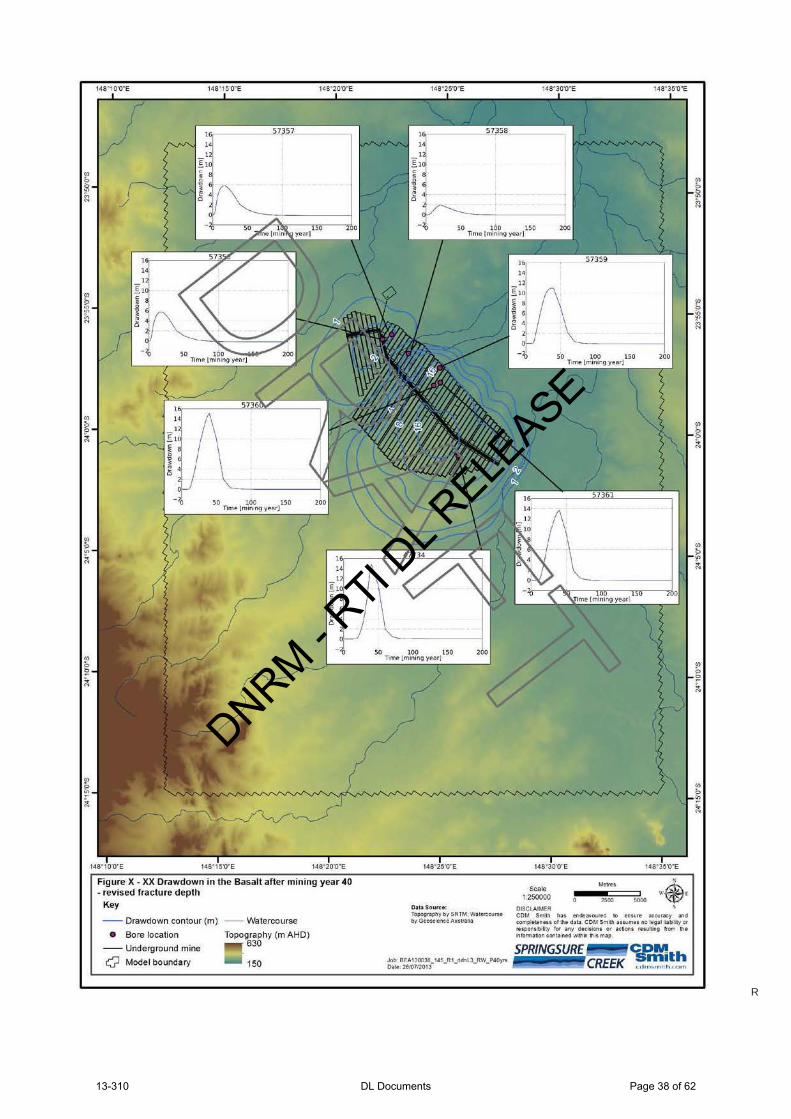
Figure X- XX Orawdown in the Basalt after mining year 40 - revised fracture depth
Key
--Orawdown contour (m) --Watercourse
• Bore location Topography (m AHD)
--Underground mine
c;? Model boundary
630
150
D:ata source: Topog.r.-,phyby SRTM; W~terco\h's•
by Geos~tenee Au!trolltl
Sc:ale 1'250000
DISCLAIMER 2~00
COM Smilh has endfa~~o~Hed to en~ure ilt~~y and toMp!•lene-ss of 11\• data. COM Smith auumu no leg-al !labl!l!y ot ruponslbllty (or illlV dtc:lsions or actions f'UU~S' trcm tht t'l fOrm:atlon eon131ned w~~ fils mllJ),
DNRM - RTI D
L RELE
ASE
13-310 DL Documents Page 38 of 62
R

Figure X- XX Maximum drawdown at the water table and the time at which maximum drawdown occurs - revised fracture depth
Key
-- Maximum drawdown contour (m) Topo~~thy (m AHD) --Underground mine
Q Model boundary 150 --Watercourse
Dlll l.a Sa ure!e: Topogn.phy by SRTM; Wateccoune by Geosc!eneeAuswiiJ
Jeb· BEA130038_143-R I_MDddnL3_13_RW_P Ca!o 26!07/2013
Sc:ale 1.250000
OJSCLAIMEft
Me.tru
2500 5000
COM Smith tlu f!rldeavourec to @nM.~re .eeur.ey and com~!enns of !he data COM Smitfl ~1t$1.imes no legalli,.biey Ot 1uponsbiity for <ln)' deeisioos or acUons ruul~g from lhei'lfOtMalion coruarned W\Ctl~ flit map
SPRINGSURE <ifJdth CREEK r r lrn,rt'l l rh ,t"<)rt'l
DNRM - RTI D
L RELE
ASE
13-310 DL Documents Page 39 of 62
R

DNRM - RTI D
L RELE
ASE
13-310 DL Documents Page 40 of 62

LegendDen-Lo Park
MLA70486
Mine Access Route
Internal access roads
Indicative subsoil stockpiles
Quarry location
Indicative topsoil storage (spreading)
Infrastructure Footprint on SCL
Impeded access to SCL
Longwall Layout
Central_Highlands Watercourses0 1 2 30.5Kilometers
Springsure Ck Coal MLA70486
1:20,000
F
DNRM - RTI D
L RELE
ASE
13-310 DL Documents Page 41 of 62

LegendSCC Infrastructure Corridor MLA70502
SCL_within_MLA70502
MLA70486
SCC_Surface Infrastructure Footprint
Longwall Layout0 1 2 3 4 5 6 7 8 9 10 11 12 13 14 15 16 17 180.5
Kilometers
Springsure Ck Coal MLA70502
F
Springsure Ck Coal MLA70486
DNRM - RTI D
L RELE
ASE
13-310 DL Documents Page 42 of 62
~~ ~ Queensland Government
Department of
Natural Resources and Mines Information Notice
Strategic Cropping Land Act 2011
Application Requisition
This statutory notice is issued under s.241 of the Strategic Cropping Land Act 2011 (SCL Act).
Springsure Creek Coal Pty Ltd c/o Bandanna Energy Limited Level 4, 260 Queen Street
Brisbane QLD 4000
Our reference: SCLRD2013/000146
Attention: Pete Jones
Dear Pete
Re: Application requisition -Application for a strategic cropping land protection decision by Springsure Creek Coal Pty Ltd for MLA70486 pursuant to the Strategic Cropping Land Act 2011 (SCL Act).
This requisition is in two parts :
A. Request for absent items of information that form part of the protection decision application requirements described under the SCL Act s97.
B. Request for absent items of information that are required to inform the decision making criteria described under the SCL Act s1 01.
Part A: Request for absent items of information that form part of the protection decision appl ication requirements described under the SCL Act s97.
Please note: The SCL Act s240 requir~s that the decision maker must refuse to receive or process a purported application not made under the requirements under this Act, for making the application. Subsequently until the following information is provided, your application can not be accepted as complete. This part of the requisition provides you with an opportunity to rectify its lodgement.
Item 1: Please provide a map 1 that identifies where the development is proposed to be carried out on potential SCL.
It is noted in your response to Question 7 of the submitted application form and in the submitted application report that an SCL validation application or decision over MLA70486 does not exist and that you have elected, for the purposes of the application assessment and decision, to accept the area of mapped potential SCL as reflecting the areas of SCL to be impacted by the development. This is not reflected on any of the maps provided in the application which subsequently misrepresents the extent of development on SCL.
In responding to this request please also accurately clarify both the location and spatial extent (area in ha) of all mine activities to be carried out on MLA70486 indicated in Section 2 of the submitted application report, including but not limited to any built infrastructure, roads, drainage and erosion/sediment control, pondages and any water/waste management infrastructure, quarrying, bulk excavations, topsoil stripping and areas subject to stockpiling or respreading of borrowed soils, laydowns, hardstands and any areas of construction-related disturbance associated with the proposed operational footprint of built infrastructure. Accurate communication of this information to DNRM and the efficiency of its assessment would benefit by providing, in addition to a representative map, the above information electronically as separate ESRI Shapefiles projected in MGA94 or alternatively, Google TM KML files.
1 The SCL Act s85(1 )(a)&(b) requires that the application must contain a map that identifies all of the SCL or potential SCL on the land and identifies where the development is proposed to be carried out on SCL or potential SCL.
Page 1 of 1 • 130821
DNRM - RTI D
L RELE
ASE
13-310 DL Documents Page 43 of 62
R

Application requisition
Item 2: Please provide in a report2, identification of the location and spatial extent (area in ha) of each of the
impacts of the development on SCL.
In accordance with the SCL Act s14 an «impact" on SCL is taken to occur when either of the following occurs:
• The proposed mining activity introduces an impediment to cropping for any period of time, irrespective of whether the land is currently being cropped. Land may be impeded from being cropped due to its occupation by mining activities or due to logistical , safety or legal restrictions on access to particular areas of land for cropping during the mine lease period. Impediments to cropping may be partial (as in an additional restriction, complication or cost on cropping) or absolute (as io the complete exclusion of cropping). Introduced impediments to cropping may be short-lived or long term. If an impediment to cropping endures for 50 years or more, the affected land is regarded under the SCL Act as being permanently impacted by the development.
• The proposed mining activity results in land disturbance that alters the condition of the land. This could entail an alteration to the soil profile or soil properties, altering the land cover, altering existing land improvements and landform modifications (dams and drainage), changing the topography or altering the surface or subsurface drainage characteristics of the land. The land's condition at the point in time prior to the development commencing, is taken to be the benchmark against which impacts that are attributable to the development are recognised. If any alteration to the pre-development condition of the land is unable to be restored, the land is regarded under the SCL Act as being permanently impacted by the development.
Note: Introduced impediments to cropping and alterations to the predevelopment condition of the land that do not have a permanent impact are regarded as temporary impacts.
Accurate communication of this information to DNRM would be assisted by providing a map illustrating the location and extent of the various impacts that are attributable to the proposed mining development, supported by separate ESRI Shapefiles of the affected areas projected in MGA94 or alternatively, Google ™ KML files.
Item 3: Please provide in a report2, an assessment of each of the identified impacting activities that clarifies the process and characteristics of each impacting activity {how it will be carried out and what it will result in - in terms of either impediments to cropping or alterations of the land or landscape processes).
By way of your responses to Items 2 & 3 and to enable efficient assessment of your application, each impacting activity should essentially be characterised by: its location; its spatial extent (area in ha), the process by which the impact occurs; what it will result in; and ultimately its duration.
Please note: The SCL Act Schedule 2 provides definitions of particular terms that have specific meaning when used in the context of a protection decision application and its assessment. In your current application some confusion of the intended meaning is created when words such as 'restoration ' and 'mitigation' have been used. For the purpose of clarity, please refrain from using the term 'restoration' unless it is used to describe a process by which land will be restored to its pre-development condition as defined. Pfease also refrain from using the term 'mitigation ' unless it is used to refer to mitigation as defined. The term 'remediation' has been used throughout this requisition to describe any process by which the impacts on SCL of development have been sought to be combated, minimised or reduced.
Part B: Request for absent items of information that are required to inform the decision making criteria
described under the SCL Act s101.
In order to decide the application the SCL Act delegate must consider the following:
a) The extent of the impact of the carrying out of the resource activity on SCL.
If addressed appropriately, this information will be provided in response to the requisitioned items 2 and 3.
b) Whether the carrying out of the resource activity will have a permanent impact or a temporary impact on the land.
As detailed above regarding item 2, permanent impacts (as defined under the SCL Act s14) will occur when either an impediment to cropping that is attributable to the development endures for 50 years or more, or when any alteration to the pre-development condition of the land that is attributable to the development is
2 The SCL Act s87(a) requires that the application must contain a report that assesses the development's impact on all SCL or potential SCL on the land.
Page 2 of 4 • 130902
Department of Natural Resources and Mines
DNRM - RTI D
L RELE
ASE
13-310 DL Documents Page 44 of 62
R

Application requ isition
unable to be restored. Conversely, impediments to cropping and alterations to the predevelopment condition of the land that do not have a permanent impact are regarded as temporary impacts.
In your response to Question 14 of the application form you have stated that the development as proposed will not have a permanent impact on the land. The application report also asserts that the impacts of the development on SCL will be temporary. This assertion is however unsupported by:
• full documentation of the extent and variety of development activities that will take place on SCL and identification of the associated impacts on SCL; and
• the provision of evidence that demonstrates how.all introduced impediments to cropping that are attributable to the development will be reliably removed within 50 years; and
• the provision of evidence that demonstrates how all alterations to the condition of the land will be reliably restored to the predevelopment condition within the term of the development.
The assertion is also contradicted in sections of the report that describe how land which has been disturbed by mining activity may be left in a state that is not consistent with its original condition- for example: treatment of access roads, dams, mine entrance, basalt quarrying, treatment of tension cracking, deformed land and ponded depressions.
Given the scale and impact of the mining activity and the aspirational remediation and decommissioning objectives outlined in the application, it does not appear that there is a clear intention to restore all impacts on SCL to their pre-development condition. It also does not appear plausible that the objective of achieving overall a temporary impact on SCL is within the scope of the development and the 'mitigation measures' described within the application which are largely aspirational rather than demonstrated with any degree of certainty.
If it is the intention to pursue a protection decision that includes all of the [yet-to-be-documented] impacts of the development being recognised as consistent with a temporary impact as defined in the SCL Act, please provide requisition items 4- 6 as follows:
Item 4: With respect to each impacting activity identified in the response to Item 2, please describe in detail the particular impediments to cropping that are attributable to each activity and the physical alterations to the condition of the land that are attributable to each activity with attention paid to the location, spatial extent (area in ha), the process by which the impact occurs; what it will result in; and ultimately its duration.
If addressed appropriately, this information will in the main be provided in response to the requisitioned items 2 and 3.
Item 5: For each impacting activity identified in response to Items 2 and 3, please prepare a detailed restoration plan that includes: detailed description of the benchmarked predevelopment site condition, the methods to be applied to ensure site restoration to that original condition including restoration milestones, the methods and timeframe for removal of any impediments to cropping (if unrelated to altered land condition), the restoration monitoring regime that will be in place including contingency plans in the event of failure to reach given milestones. A reliable timeframe for complete restoration to predevelopment condition and removal of impediments to cropping for each impact that is to be restored is also required.
Item 6: Based on the restoration plans prepared in response to Item 5, please provide a thorough and detailed calculation of the costs of SCL impact restoration and removal to the standard required by the temporary impact definition. By making comparisons between the calculated SCL restoration/removal costs for particular impacts and the attributable Financial Assurance required under the EP Act for mine rehabilitation where relevant to those impacts, please provide a net figure for SCL Financial Assurance liability for the project. Any SCL Financial Assurance figure quoted must be fully qualified by castings of actions required by the plan for restoration of impacts on SCL and comparison with casted actions that form part of the Financial Assurance attributable for the Environmental Authority.
2 The SCL Act s87(a) requires that the application must contain a report that assesses the development's impact on all SCL or potential SCL on the land.
Page 3 of 4 • 130902 Department of Natural Resources and Mines
DNRM - RTI D
L RELE
ASE
13-310 DL Documents Page 45 of 62
R

Application requisition
c) Whether the applicant has demonstrated that the impact has been avoided or minimised to the greatest extent practicable.
Item 7: Please confirm and describe what areas of land (if any) within MLA70486 will remain available for
cropping and unaltered by mining throughout the entire duration of the mining tenure.
Item 8: Please confirm and describe whether any areas of land or landscape processes (including overland
flow and drainage patterns) outside MLA70486 will be altered or disrupted as a result of the proposed
mining activities and consequent landscape alterations.
The application declares an intention to, where possible; bring land affected by mining activities and
consequent land deformation and drainage pattern disruption back into crop production. However it is not
clear what physical remediation measures will be undertaken to bring impacted land back into a condition
where it may again be cropped.
Item 9: Following documentation of the extent and mode of all impacting activities in response to requisition
Item 2 and 3, please document any remedial measures that will be employed to minimise the consequences
of the impacts on SCL for its future productive use. Please document separately the remediation techniques
that will be applied to land affected by different impacts. For example, minimising the impacts on land
affected by subsidence and deformation may be treated differently than land affected by road construction
or industrial infrastructure. These remedial measures must be described with a level of detail and certainty
that enables both an assessment of their suitability and the scripting of protection decision conditions to
ensure they are reliably implemented and able to be monitored.
If you have any questions about this notice, please contact Andrew Mclaughlin whose contact details are listed
below.
Yours sincerely
Signature
Errol Sander
Project Manager
Property Planning and Assessment
Central Region
Department of Natural Resources and Mines
Date
Enquiries: Andrew Mclaughlin
Senior Natural Resource Management Officer
PO Box 383, Gympie OLD 4570
Phone: 07 5480 5336 Email: Andrew.Mclaughlin@dnrm .gld.gov .au
2 The SCL Act s87(a) requires that the application must contain a report that assesses the development's impact on all SCL or potential SCL on the land.
Page 4 of 4 • 130902
Department of Natural Resources and Mines
DNRM - RTI D
L RELE
ASE
13-310 DL Documents Page 46 of 62
49-Sch4 - Personal Information

Author : Sue Crowley
Ref number: SCLRD2013/000146
23 October 2013
Mr Pete Jones
Bandanna Energy Ltd
Level 4, 260 Queen Street
Brisbane QLD 4000
• Queensland Government
Department of
Natural Resources and Mines
Re: Springsure Creek Coal Mine Project protection decision SCLRD2013/ 000146
Dear Pete
Thank you for the additional information, GIS files and amended application report provided
by email on 18 October 2013. Please be advised that the Springsure Creek Coal Pty Ltd SCL
application ref: SCLRD2013/000146 is now accepted by DNRM as fulfilling the application
requirements as per s96 and s97 of the SCL Act.
During the course of the assessment you will be contacted if any further clarification of your
resource development proposal is required. Please contact Andrew Mclaughlin, DNRM
Senior Natural Resource Management Officer on 07 5480 5336 if you have any questions
regarding the application assessment.
Yours sincerely
Errol Sander
Project Manager
Property Planning and Assessment
Central Region
Department of Natural Resources and Mines
DNRM - RTI D
L RELE
ASE
13-310 DL Documents Page 47 of 62
49-Sch4 - Personal Information

636000.000000
636000.000000
638000.000000
638000.000000
640000.000000
640000.000000
642000.000000
642000.000000
644000.000000
644000.000000
646000.000000
646000.000000
648000.000000
648000.000000
7342
000.0
000
00
7342
000.0
000
00
7345
000.0
000
00
7345
000.0
000
00
7348
000.0
000
00
7348
000.0
000
00
7351
000.0
000
00
7351
000.0
000
00
7354
000.0
000
00
7354
000.0
000
00
7357
000.0
000
00
7357
000.0
000
00
Watercourse (& stream order) ML Area 'A' Area 'B' Area 'C'
0 1 2 3 4 50.5 Kilometres
Plan SCLRD2013/000146(1): SCL Protection Decision disturbance areas and watercourses
Date: 18/12/2013
DNRM - RTI D
L RELE
ASE
13-310 DL Documents Page 48 of 62

636000.000000
636000.000000
638000.000000
638000.000000
640000.000000
640000.000000
642000.000000
642000.000000
644000.000000
644000.000000
646000.000000
646000.000000
648000.000000
648000.000000
7342
000.0
000
00
7342
000.0
000
00
7345
000.0
000
00
7345
000.0
000
00
7348
000.0
000
00
7348
000.0
000
00
7351
000.0
000
00
7351
000.0
000
00
7354
000.0
000
00
7354
000.0
000
00
7357
000.0
000
00
7357
000.0
000
00
Area 'A' Area 'B' Area 'C' Watercourse (& stream order)
0 1 2 3 4 50.5 Kilometres
Plan SCLRD2013/000146(1): SCL Protection Decision disturbance areas and watercourses
Date: 18/12/2013
DNRM - RTI D
L RELE
ASE
13-310 DL Documents Page 49 of 62

LegendSCC_ modelled_subsidence_affected_SCL
DNRM_Longwall_perimeter
DNRM_Longwall_Perimeter_clipped_to_SCL
SCC_Surface Infrastructure Footprint
MLA70486
Longwall Layout
0 1 2 3 4 5 6 7 80.5Kilometers
Springsure Ck Coal MLA70486
F
DNRM - RTI D
L RELE
ASE
13-310 DL Documents Page 50 of 62
R

Parameter Symbol Value Unit
Depth of cover H 250 mSeam thickness tc 3.7 mPanel width W 300 mWidth: cover ratio W/H 1.20 criticalPillar width Pw 40 m
Suggested valuesks 0.65 0.28k1 0.4 0.4k2 1 1.0k3 3.3 3.2
Maximum subsidence Smax 2.4 m
Tensile strain +Emax 4 mm/m
Compressive strain Emax 10 mm/m
Tilt Gmax 32 mm/m3.2 %
Empirical factors select value from drop down list
Predicted results
Seam characteristics
DNRM - RTI D
L RELE
ASE
13-310 DL Documents Page 51 of 62

DNRM - RTI D
L RELE
ASE
13-310 DL Documents Page 52 of 62
R

Parameter Symbol Value Unit
Depth of cover H 215 mPanel width W 300 mSeam thickness tc 3.7 m
W/H 1.4
Empirical factors Indicative valueks 0.65 0.65k1 0.40 0.40k2 1.0 1.0k3 3.3 3.2
Maximum subsidence Smax 2.4 m
Tensile strain +Emax 4 mm/m
Compressive strain Emax 11 mm/m
Maximum tilt Gmax 37 mm/mOR 3.7 %
Predicted results
Seam characteristics
Select list value:
DNRM - RTI D
L RELE
ASE
13-310 DL Documents Page 53 of 62

Parameter Symbol Value Unit
Depth of cover H 250 mSeam thickness tc 3.7 mPanel width W 300 mWidth: cover ratio W/H 1.20 criticalPillar width Pw 40 m
Suggested valuesks 0.65 0.28k1 0.4 0.4k2 1 1.0k3 3.3 3.2
Maximum subsidence Smax 2.4 m
Tensile strain +Emax 4 mm/m
Compressive strain Emax 10 mm/m
Tilt Gmax 32 mm/m3.2 %
Empirical factors select value from drop down list
Predicted results
Seam characteristics
DNRM - RTI D
L RELE
ASE
13-310 DL Documents Page 54 of 62

CHIA facilities
haul rd
Mine Water Dam
Environmental Dam
Environmental Dam
Raw Water Dam
Unknown - DS CL Pad
Drift Portal Entry
Environmental Dam
Environmental Dam
Main Site Access Road
Vent Access Road
Mine Industrial Area
Unknown - am PD02 StrsDrift Access Road
Hardstand Area
Vent Maintenance Access Road
Unknown - VP HV
Waste Pad Access Road
CHP Access Road
Vent Fan and Mine Services
CHIA Access Road
STP and Effluent Dam
Unknown - am PD14 Strs
Unknown - am PD03 Strs
CHP Access Road
CHP Access Road
Unknown - am PD10 Strs
LegendSurface Infrastructure Footprint
0 10.5Kilometers
Springsure Ck Coal MLA70486
F
DNRM - RTI D
L RELE
ASE
13-310 DL Documents Page 55 of 62

feetmeters
1000500
DNRM - RTI D
L RELE
ASE
13-310 DL Documents Page 56 of 62

# Sample ID Upper Lower Median pH EC1:5 Chloride SOC Nitrate N Colwell P CEC Ca Mg K Na ESP Ca:Mg Clay Silt FSand CSand Gravel SAR Sand CCR Site1 TP1 0 0.1 0.05 7.5 0.02 100 1.75 14 25 50 35 10 0.5 3.5 7.0 3.5 65 25 5 2 3 6.2 7.2 0.77 12 23 24 25 26 27 28 29 2
10 211 212 213 214 215 216 217 218 219 220 221 222 223 224 225 226 227 228 229 230 231 232 233 234 235 236 237 238 239 240 241 242 243 244 245 246 247 248 249 250 251 252 253 254 255 256 257 258 259 260 261 262 263 264 265 266 267 268 269 270 271 272 273 274 275 276 277 278 279 280 281 282 283 284 285 286 287 288 289 290 291 292 293 294 295 296 297 298 299 2
100 2101 2102 2103 2104 2105 2106 2107 2108 2109 2110 2111 2112 2113 2114 2115 2116 2117 2118 2119 2120 2121 2122 2123 2124 2125 2126 2127 2128 2129 2130 2131 2132 2133 2134 2135 2136 2137 2138 2139 2140 2141 2142 2143 2144 2145 2146 2147 2148 2149 2150 2151 2152 2153 2154 2155 2156 2157 2158 2159 2160 2161 2162 2163 2164 2165 2166 2167 2168 2169 2170 2171 2172 2173 2174 2175 2176 2177 2178 2179 2180 2181 2182 2183 2184 2185 2186 2187 2188 2189 2190 2191 2192 2193 2194 2195 2196 2197 2198 2199 2200 2201 2202 2203 2204 2205 2206 2207 2208 2209 2210 2211 2212 2213 2214 2215 2216 2217 2218 2219 2220 2221 2222 2223 2224 2225 2226 2227 2228 2229 2230 2231 2232 2233 2234 2235 2236 2237 2238 2239 2240 2241 2242 2243 2244 2245 2246 2247 2248 2249 2250 2
DNRM - RTI D
L RELE
ASE
13-310 DL Documents Page 57 of 62

Sample Clay % Sand % Silt %1 59 18 23 Plotting parameters area2 50 30 20 Error messages3 37 56 5 Printer correction: 1.14 57 23 20 Tick interval (0 0.5): 0.15 27 66 7 Tick length (0 0.2): 06 15 49 21 Plot lines? (Y or N): y7 46 28 188 46 30 229 38 32 28
10 65 14 2111 55 24 2112 33 55 1113 23 60 1714 29 46 1715 34 44 1816 37 43 1917 28 57 1218 51 36 1219 51 36 1220 45 42 1221 54 24 2122 38 39 1923 62 16 2224 50 28 1925 55 22 2326 38 37 2527 50 30 2028 37 56 529 57 23 2030 27 66 731 46 30 2232 15 49 2133 38 29 1934 33 55 1135 55 24 2136 65 14 2137 38 32 2838 23 60 1739404142434445464748495051525354555657585960616263646566676869707172737475767778798081828384858687888990919293949596979899
100101102103104105106107108109110111112113114115116117118119120121122123124125126127128129130131132133134135136137138139140141142143144145146147148149150151152153154155156157158159160161162163164165166167168169170171172173174175176177178179180181182183184185186187188189190191192193194195196197198199200201202203204205206207208209210211212213214215216217218219220221222223224225226227228229230231232233234235236237238239240241242243244245246247248249250
Proportion
Clay % Silt %
Sand %
100
0100
100
0
0
ClaySilty clay
Silty clay loam
Silty loam
Clay loam
Loam
Loamy sand
Sandy loam
Sandy clay loam
Sandy clay
Sand
DNRM - RTI D
L RELE
ASE
13-310 DL Documents Page 58 of 62

i, 2 yr, 6 hr = 10.4 mm/hr (from IFD data)R = 2374 (refer map in column E for verification)Soil ID Site 20 Site 62 Surface soil% silt = 30 30 Blocky, platy or mas 4% f sand = 11 5 Fine granular 2% clay = 59 65 Medium granular 3% OC = 1 1.3 Very fine granular 1M = 1681 1225OM = 1.7 2.2 InfiltrationSoil structure Medium granular Medium granular Moderate 3Permeability Slow / moderate Slow Moderate / rapid 2SS = 3 3 Rapid 1PP = 4 5 Slow 5K = 0.021 0.020 Slow / moderate 4Check OK OK Very slow 6
L= 100 100S= 3 4.5AHT= 3 4.5 Crop
= 0.030 0.045 Annual crop / averag 0.35= 100.045 100.101 Annual crop / excelle 0.1= 0.45 0.62 Annual crop / good 0.2
m = 0.31 0.38 Annual crop / poor 0.5L = 1.60 1.78 Bare soil 1S = 0.35 0.52 Pasture 40% cover 0.1LS = 0.57 0.92 Pasture 80% cover 0.01
Undisturbed forest 0.003Practice No erosion control practice No erosion control practiceP = 1 1 Practice
Contour banks 1 - 3 0.34Crop Annual crop / average Annual crop / average Contour banks 3 - 5 0.59C = 0.35 0.35 Contour banks 5 - 8 0.69
Contour cultivation 1 0.85A = 9.9 15.1 t/ha/yr Contour cultivation 3 0.8SUMMARY TABLE Contour cultivation 5 0.85Factor Units Site 20 Site 62 No erosion control p 1Rainfall (R) MJ.mm/ha.hr.yr 2374 2374 Strip cropping 0.75Erosivity (K) t.ha.hr/ha.MJ.mm 0.021 0.020Slope length (LS) 0.57 0.919Practice (P) 1 1Crop (C) 0.35 0.35Soil loss (A) t/ha/yr 9.9 15.1
K = 2.77 M1.14 (10-7) (12-0M) + 4.28 (10-3) (SS-2) + 3.29 (10-3) (PP-3)
M = % silt & vfs x 100 - % clayOM = % organic matterSS = soil structure codePP = profile permeability class
DNRM - RTI D
L RELE
ASE
13-310 DL Documents Page 59 of 62

Figure X- XX Drawdown in the Basalt after mining year 40 • uncertainty case 2
Key
--Drawdown contour (m) --Watercourse
• Bore location Topography (m AHD)
--Underground mine
c;? Model boundary
630
150
D~ta Soun:•: Topogr.1~1ly by S'RTM; V'tat•rcovr5e byGt()SCitMeAusualla
Scale 1:250000
OISCLAU.AER
148"35'0"E
Mtttes
2500
COM Smi lh h<ls ~nd~avoo~CI to ~nsu.re aocooracy Clnd oomple»neu o f the data. COM Smllh auurnes no le~l liabllly or r.&poMt.&ty tor ;any declston5 or ;at-tions ruulting from th• lnfotm3!10n cont3ined v.lltlln !:tl ls m3p.
DNRM - RTI D
L RELE
ASE
13-310 DL Documents Page 60 of 62
R

Note: area circled in red is where the Basalt is completely drained/dewatered.
Figure X- XX Maximum drawdown at the water table and the time at which maximum drawdown occurs - uncertainty case 2
Key
--Maximum drawdown contour (m) --vvatercourse
--Basalt dry area TopoW~8hy (m AHDJ --Underground mine
Q Model boundary 150 O~te 2610TJ2013
Dlll l.a Sa ure!e: Topogn.phy by SRTM; Wateccoune by Geosc!eneeAuswiiJ
Sc:ale 1.250000
OJSCLAIMEft
Me.tru
2500 5000
COM Smith tlu f!rldeavourec to @nM.~re .eeur.ey and com~!enns of !he data COM Smitfl ~1t$1.imes no legalli,.biey Ot 1uponsbiity for <ln)' deeisioos or acUons ruul~g from lhei'lfOtMalion coruarned W\Ctl~ flit map
SPRINGSURE <ifJdth CREEK r r lrn,rt'l l rh ,t"<)rt'l
DNRM - RTI D
L RELE
ASE
13-310 DL Documents Page 61 of 62
R

Mine dewatering rate peaks at 12.8 ML/d (148 L/s), compared to approximately 3.8 ML/d (44 L/s) for the base case scenario.
DNRM - RTI D
L RELE
ASE
13-310 DL Documents Page 62 of 62