Embed Size (px)
Citation preview

UN Economic Commission for Europe Section 2: Data Standard Inland ECDIS Standard Appendix A: Object Catalogue
Edition 1.0 Section 2_Appendix A page 1 31.05.2001
Edition 1.0 31.05.2001
Standard
Electronic Chart Display and Information System for Inland Navigation
Inland ECDIS
SECTION 2
Data Standard for Inland ECDIS
Appendix A
Object Catalogue for Inland ECDIS
in addition to the
IHO-S-57 Object Catalogue

UN Economic Commission for Europe Section 2: Data Standard Inland ECDIS Standard Appendix A: Object Catalogue Contents
Edition 1.0 Section 2_Appendix A Page 2 31.05.2001
Contents
1 Introduction......................................................................................................................... 18
1.1 The Object Catalogue........................................................................................................... 18
1.2 Extensions of the object classes and attributes .................................................................... 21
1.3 Conventions used in this document for types ....................................................................... 21
2 Geo Object Classes (copied)............................................................................................. 22 Anchor berth ........................................................................................................................... 22 Anchorage area ...................................................................................................................... 23 Berth ....................................................................................................................................... 24 Bridge ..................................................................................................................................... 25 Cable overhead ...................................................................................................................... 26 Canal bank ............................................................................................................................. 27 Depth area.............................................................................................................................. 28 Distance mark......................................................................................................................... 29 Ferry route .............................................................................................................................. 30 Harbour Area .......................................................................................................................... 31 Harbour Facilities.................................................................................................................... 32 Lock Basin .............................................................................................................................. 33 Radio calling-in point .............................................................................................................. 34 Restricted area ....................................................................................................................... 35 River bank .............................................................................................................................. 36 Signal station traffic ................................................................................................................ 37 Signal station warning............................................................................................................. 38 Top Mark ................................................................................................................................ 39
3 Meta Object Classes (copied)............................................................................................ 40 Navigational system of marks................................................................................................. 40
4 Geo Object Classes (new) ................................................................................................. 41 Beacon water-way .................................................................................................................. 41 Bridge area ............................................................................................................................. 42 Bunker station......................................................................................................................... 43 Buoy water-way ...................................................................................................................... 44 Communication Area .............................................................................................................. 45 Harbour Basin......................................................................................................................... 46 Lock area................................................................................................................................ 47 Lock basin part ....................................................................................................................... 48 Notice mark ............................................................................................................................ 49 Port Area................................................................................................................................. 50 Refuse dump .......................................................................................................................... 51 Route planning point............................................................................................................... 52 Terminal.................................................................................................................................. 53 Turning basin .......................................................................................................................... 54 Waterway axis ........................................................................................................................ 55 Waterway profile..................................................................................................................... 56
5 Object Attributes (copied).................................................................................................. 57 Category of Anchorage area................................................................................................... 57 Category of bridge .................................................................................................................. 58 Category of distance mark...................................................................................................... 59

UN Economic Commission for Europe Section 2: Data Standard Inland ECDIS Standard Appendix A: Object Catalogue Contents
Edition 1.0 Section 2_Appendix A Page 3 31.05.2001
Category of ferry ..................................................................................................................... 60 Category of harbour facilities .................................................................................................. 61 Category of signal station traffic.............................................................................................. 62 Category of signal station warning.......................................................................................... 63 Marks navigational – System of.............................................................................................. 64 Restriction............................................................................................................................... 65 Vertical datum......................................................................................................................... 66
6 Object Attributes (new) ...................................................................................................... 67 Additional mark ....................................................................................................................... 67 Bunker vessel, availability....................................................................................................... 68 Category of bank .................................................................................................................... 69 Category of berth .................................................................................................................... 70 Category of bunker station...................................................................................................... 71 Category of CEMT class......................................................................................................... 72 Category of communication .................................................................................................... 73 Category of harbour area........................................................................................................ 74 Category of notice mark.......................................................................................................... 75 Category of refuse dump ........................................................................................................ 78 Category of terminal ............................................................................................................... 79 Category of waterway mark (buoy, beacon) ........................................................................... 80 Class of dangerous cargo....................................................................................................... 81 Communication....................................................................................................................... 82 Direction of impact .................................................................................................................. 83 Distance from bank, first ......................................................................................................... 84 Distance from bank, second ................................................................................................... 85 Distance of impact, upstream ................................................................................................. 86 Distance of impact, downstream............................................................................................. 87 Elevation 1 .............................................................................................................................. 88 Elevation 2 .............................................................................................................................. 89 Function of notice mark .......................................................................................................... 90 Horizontal clearance, length ................................................................................................... 91 Horizontal clearance, width..................................................................................................... 92 Transshipping goods .............................................................................................................. 93 UN Location Code .................................................................................................................. 94 Update message..................................................................................................................... 95 National update message ....................................................................................................... 96 Waterway distance ................................................................................................................. 97
7 Overview of Inland ECDIS Object Classes and Attributes ............................................. 98
8 List of additional used S-57 Object Attributes............................................................... 100

UN Economic Commission for Europe Section 2: Data Standard Inland ECDIS Standard Appendix A: Object Catalogue 1 Introduction
Edition 1.0 Section 2_Appendix A Page 18 31.05.2001
1 Introduction
In the S-57 data model hydrographic information is represented as a defined combination of descriptive and
spatial characteristics, called ‘feature objects‘ and ‘spatial objects‘. Details of further classification and rela-
tionships can be found in the respective publications of the IHO. In the S-57 standard, the IHO has laid
down a data model, an object catalogue, a description of the exchange format and an ENC product specifi-
cation.
In order to represent data necessary for inland waterway traffic in an application conforming to S-57, the
S-57 object catalogue must be enhanced by the required object classes, attributes and values. Such en-
hancements in terms of ‘user defined objects‘ are allowed in the S-57 standard and there are means to
incorporate them.
1.1 The Object Catalogue
In the object catalogue, all official IHO object classes along with their allowed attributes and attribute values
are defined. The Inland ECDIS object catalogue can be compared to the Chart 1 (INT 1) of the sea charts
and additionally contains the special object classes and attributes for inland waterways.
The following types of feature objects exist:
Geo: descriptive characteristics of the real world
Meta: additional area related information, e.g. survey source
Collection: information about relationships between objects
UN Economic Commission for Europe Section 2: Data Standard Inland ECDIS Standard Appendix A: Object Catalogue 1 Introduction
Edition 1.0 Section 2_Appendix A Page 19 31.05.2001
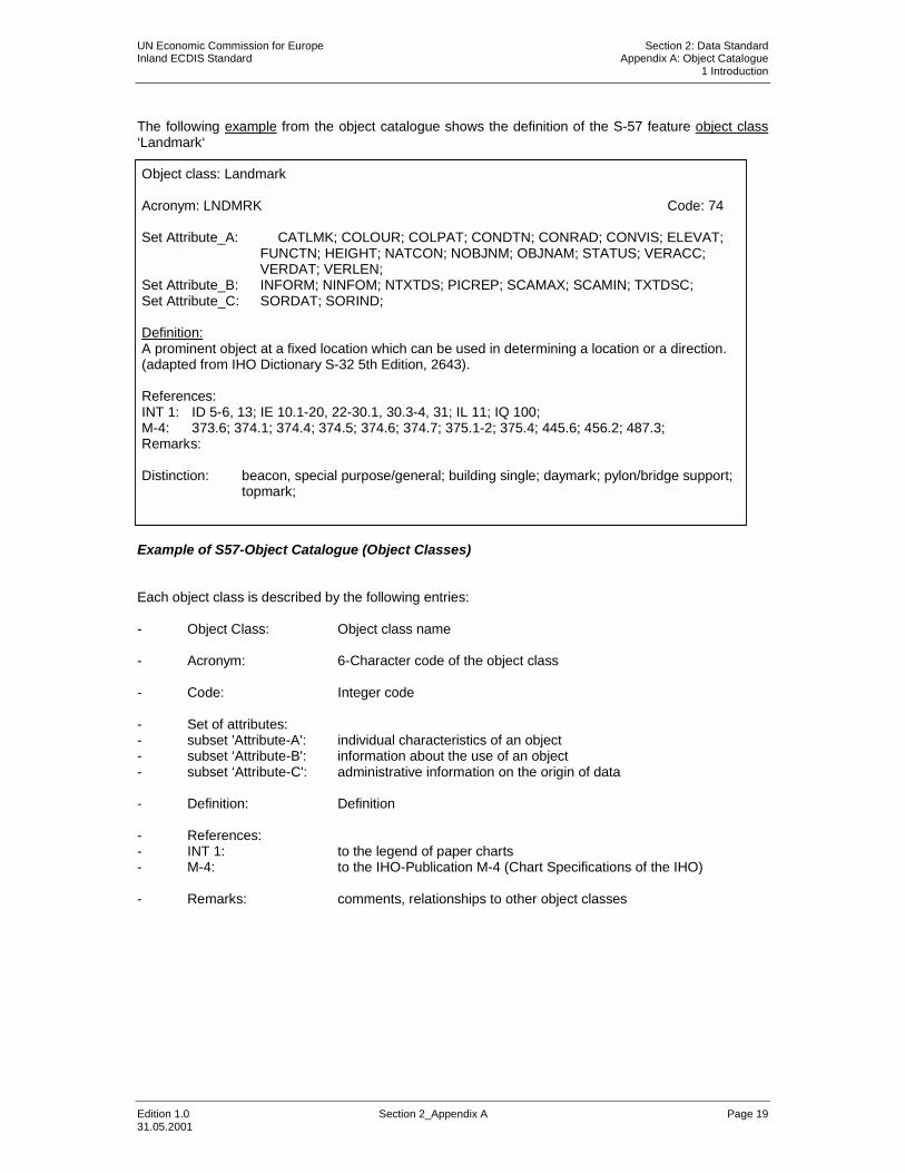
The following example from the object catalogue shows the definition of the S-57 feature object class ‘Landmark‘
Example of S57-Object Catalogue (Object Classes) Each object class is described by the following entries: - Object Class: Object class name - Acronym: 6-Character code of the object class - Code: Integer code - Set of attributes: - subset 'Attribute-A': individual characteristics of an object - subset ‘Attribute-B': information about the use of an object - subset ‘Attribute-C': administrative information on the origin of data - Definition: Definition - References: - INT 1: to the legend of paper charts - M-4: to the IHO-Publication M-4 (Chart Specifications of the IHO) - Remarks: comments, relationships to other object classes
Object class: Landmark Acronym: LNDMRK Code: 74 Set Attribute_A: CATLMK; COLOUR; COLPAT; CONDTN; CONRAD; CONVIS; ELEVAT;
FUNCTN; HEIGHT; NATCON; NOBJNM; OBJNAM; STATUS; VERACC; VERDAT; VERLEN;
Set Attribute_B: INFORM; NINFOM; NTXTDS; PICREP; SCAMAX; SCAMIN; TXTDSC; Set Attribute_C: SORDAT; SORIND; Definition: A prominent object at a fixed location which can be used in determining a location or a direction. (adapted from IHO Dictionary S-32 5th Edition, 2643). References: INT 1: ID 5-6, 13; IE 10.1-20, 22-30.1, 30.3-4, 31; IL 11; IQ 100; M-4: 373.6; 374.1; 374.4; 374.5; 374.6; 374.7; 375.1-2; 375.4; 445.6; 456.2; 487.3; Remarks: Distinction: beacon, special purpose/general; building single; daymark; pylon/bridge support;
topmark;

UN Economic Commission for Europe Section 2: Data Standard Inland ECDIS Standard Appendix A: Object Catalogue 1 Introduction
Edition 1.0 Section 2_Appendix A Page 20 31.05.2001
The following example from the object catalogue shows the definition of the S-57 attribute ‘Category of landmark‘
Example of S-57-Object Catalogue (Attributes) Each attribute is described by the following entries: - Attribute: attribute name - Acronym: 6-character code of the attribute - Code: Integer Code - Attribute type: 1-character code for the data type - enumerated (‘E’): exactly one value selected from a list of pre-defined attribute values - list (‘L’): one or more values selected from a list of pre-defined attribute values - float (‘F’): floating point numeric value - integer (‘I’): integer numeric value - coded string (‘A’): string of ASCII characters in a predefined format - free text (‘S’): free-format alphanumeric string - Expected input (value): expected input according to the above mentioned input types - Definitions: Definition -
References: - INT 1: to the legend of paper charts - M-4: to the IHO-Publication M-4 (Chart Specifications of the IHO) -
Remarks: Comments, relations to other attributes
Attribute class: Category of landmark Acronym: CATLMK Code: 35 Attribute type: L Expected input (value): ID Meaning INT 1 M-4 1 : cairn IQ 100; 456.2; ... : ........ .......... ........; 20 : spire/minaret IE 10.3, 17; Definitions: cairn: a mound of stones, usually conical or pyramidal, raised as a landmark or to desig-
nate a point of importance in surveying. (IHO Dictionary, S-32, 5th Edition, 601) ......... : ........... spire/minaret: a tall conical or pyramid-shaped structure often built on the roof or tower of a build-
ing, especially a church or mosque. (adapted from The New Shorter Oxford English Dictionary, 1993)
Remarks: No remarks

UN Economic Commission for Europe Section 2: Data Standard Inland ECDIS Standard Appendix A: Object Catalogue 1 Introduction
Edition 1.0 Section 2_Appendix A Page 21 31.05.2001
1.2 Extensions of the object classes and attributes
The extension of existing S-57 object classes with new attributes, and the extension of S-57 attributes with
new values are not allowed. Therefore, the S-57 object classes and attributes, which are to be extended
according to the requirements of Inland ECDIS, must be copied. Object classes are copied with their com-
plete set of attributes, and attributes are copied with their complete list of attribute values. All new object
classes and attributes have the same name as their source but the names are written in lower- case letters.
Reasons for copied object classes:
• Existing object class gets a new attribute, e.g. the object "canal bank" gets the new attribute "category
of bank".
•
Existing object class gets a copied attribute with new values, e.g. the attribute "category of anchorage
area" of the object "anchorage area" gets the new values 10 – 12.
• Existing object class shall be symbolized in another way, e.g. top marks.
Reason for new object classes:
•
Real world object can not be transferred into the S-57 world.
Reason for copied attributes:
• A new value is needed for an existing attribute.
Reason for new atributes:
•
A new attribute with new values is needed.
Procedure with copied object classes and attributes:
The original object classes (i. e. RESARE) and attributes remain in the Presentation Library in order to
enable the presentation of older charts. In the data production for Inland ECDIS only the copied object
classes (i. e. resare) and attributes are used.
The Integer Codes for the copied and new object classes and attributes have to be registered at the "Open
ECDIS Forum" at www.openecdis.org
1.3 Conventions used in this document for types
bold lower case new and copied object classes and attributes,
new values to attributes.
UPPER CASE old objects and attributes (already existing in S-57 Ed. 3.0 and used
without in Inland ECDIS)
lower case old values to attributes

UN Economic Commission for Europe Section 2: Data Standard Inland ECDIS Standard Appendix A: Object Catalogue 2 Copied Geo Object Classes
Edition 1.0 Section 2_Appendix A Page 22 31.05.2001
Object Classes
COPIED GEO OBJECT CLASS
Object class Anchor berth
ACRONYM achbrt Code: 17000
Set Attribute_A: catach; clsdng; comctn; DATEND; DATSTA; NOBJNM; OBJNAM; PEREND; PERSTA; restrn; STATUS; Set Attribute_B: INFORM; NINFOM; NTXTDS; PICREP; SCAMIN; TXTDSC; updmsg Set Attribute_C: SORIND; SORDAT Definition:
A designated area of water where a single vessel, sea plane, etc... may anchor.
References:
INT 1: IN 11.1-2; M-4: 431.2; Remarks: In general the anchor berth is defined by the centre point and a swinging circle.
Distinction: anchorage area; berth; mooring/warping facility;

UN Economic Commission for Europe Section 2: Data Standard Inland ECDIS Standard Appendix A: Object Catalogue 2 Copied Geo Object Classes
Edition 1.0 Section 2_Appendix A Page 23 31.05.2001
Object Classes
COPIED GEO OBJECT CLASS
Object class Anchorage area
ACRONYM achare Code: 17001
Set Attribute_A: catach; clsdng; comctn; DATEND; DATSTA; NOBJNM; OBJNAM; PEREND; PERSTA; RESTRN; STATUS; Set Attribute_B: INFORM; NINFOM; NTXTDS; PICREP; SCAMIN; TXTDSC; updmsg Set Attribute_C: SORIND; SORDAT Definition:
An area in which vessels anchor or may anchor. (IHO Dictionary, S-32, 5th Edition, 130) References:
INT 1: IN 12.1-9; M-4: 431.3;
Remarks: Distinction: anchor berth; berth, mooring/warping facility;

UN Economic Commission for Europe Section 2: Data Standard Inland ECDIS Standard Appendix A: Object Catalogue 2 Copied Geo Object Classes
Edition 1.0 Section 2_Appendix A Page 24 31.05.2001
Object Classes
COPIED GEO OBJECT CLASS
Object class Berth
ACRONYM berths Code: 17010
Set Attribute_A: catbrt; comctn; DATEND; DATSTA; DRVAL1; NOBJNM; OBJNAM; PEREND;
PERSTA; QUASOU; SOUACC; STATUS; trshgd, verdat Set Attribute_B: INFORM; NINFOM; NTXTDS; PICREP; SCAMIN; TXTDSC; updmsg Set Attribute_C: SORIND; SORDAT Definition:
A named or numbered place where a vessel is moored at a wharf. (IHO Dictionary, S-32, 5th Edition, 470)
References:
INT 1: IF 19;
M-4: 321.1; Remarks: Distinction: anchor berth; anchorage area, mooring/warping facility;

UN Economic Commission for Europe Section 2: Data Standard Inland ECDIS Standard Appendix A: Object Catalogue 2 Copied Geo Object Classes
Edition 1.0 Section 2_Appendix A Page 25 31.05.2001
Object Classes
COPIED GEO OBJECT CLASS
Object class Bridge
ACRONYM bridge Code: 17011
Set Attribute_A: catbrg; comctn; COLOUR; COLPAT; CONDTN; CONRAD; CONVIS;
DATEND; DATSTA; HORACC; HORCLR; NATCON; NOBJNM; OBJNAM; TIMEND; TIMSTA; VERACC; VERCCL; VERCLR; VERCOP; verdat
Set Attribute_B: INFORM; NINFOM; NTXTDS; PICREP; SCAMIN; TXTDSC; updmsg Set Attribute_C: SORIND; SORDAT Definition:
A structure erected over a depression or an obstacle such as a body of water, railroad, etc. to provide a roadway for vehicles, pedestrians or to carry utility services. (IHO Dictionary, S-32, 5th Edition, 544)
References:
INT 1: ID 20, 21, 22, 23.1-6, 24; M-4: 381.1-3;
Remarks:
A bridge may consist of portions which cover the land and the water. The bridge supports are encoded as pylon/bridge supports (PYLONS).
Distinction: bridge area, pylon/bridge support

UN Economic Commission for Europe Section 2: Data Standard Inland ECDIS Standard Appendix A: Object Catalogue 2 Copied Geo Object Classes
Edition 1.0 Section 2_Appendix A Page 26 31.05.2001
Object Classes
COPIED GEO OBJECT CLASS
Object class Cable overhead
ACRONYM cblohd Code: 17012
Set Attribute_A: CATCBL; CONDTN; CONRAD; CONVIS; DATEND; DATSTA; ICEFAC;
NOBJNM; OBJNAM; STATUS; VERACC; VERCLR; VERCSA; verdat; Set Attribute_B: INFORM; NINFOM; NTXTDS; SCAMAX; SCAMIN; TXTDSC; Set Attribute_C: RECDAT; RECIND; SORDAT; SORIND; Definition: An overhead cable is an assembly of wires or fibres, or a wire rope or chain, which is supported by structures such as poles or pylons and passing over or nearby navigable waters. (Hydrographic Ser-vice, Royal Australian Navy). References: INT 1: ID 26, 27 M-4: 382; 382.1-2;
Remarks: The cable supports are encoded as power transmission pylon/pole (PYLONS).
Distinction: cable area; cable, submarine; conveyor; pylon/bridge support;

UN Economic Commission for Europe Section 2: Data Standard Inland ECDIS Standard Appendix A: Object Catalogue 2 Copied Geo Object Classes
Edition 1.0 Section 2_Appendix A Page 27 31.05.2001
Object Classes
COPIED GEO OBJECT CLASS
Object class Canal bank
ACRONYM canbnk Code: 17002
Set Attribute_A: catbnk; CONRAD; NATSUR; NOBJNM; OBJNAM; Set Attribute_B: INFORM; NINFOM; NTXTDS; PICREP; SCAMIN; TXTDSC; updmsg Set Attribute_C: SORIND; SORDAT Definition:
The limit line between the water area of a canal and the land area. References:
INT 1: IF 40; M-4: 361.6;
Remarks: Distinction: canal; coastline; lake shore; river bank; shoreline construction;

UN Economic Commission for Europe Section 2: Data Standard Inland ECDIS Standard Appendix A: Object Catalogue 2 Copied Geo Object Classes
Edition 1.0 Section 2_Appendix A Page 28 31.05.2001
Object Classes
COPIED GEO OBJECT CLASS
Object class Depth area
ACRONYM depare Code: 17003
Set Attribute_A: DRVAL1; DRVAL2; eleva1; eleva2; wtwdis; QUASOU; SOUACC; Set Attribute_B: INFORM; NINFOM; NTXTDS; PICREP; SCAMIN; TXTDSC; updmsg Set Attribute_C: SORIND; SORDAT Definition:
A depth area is a water area whose depth is within a defined range of values. References: Remarks:

UN Economic Commission for Europe Section 2: Data Standard Inland ECDIS Standard Appendix A: Object Catalogue 2 Copied Geo Object Classes
Edition 1.0 Section 2_Appendix A Page 29 31.05.2001
Object Classes
COPIED GEO OBJECT CLASS
Object class Distance mark
ACRONYM dismar Code: 17004
Set Attribute_A: catdis; DATEND; DATSTA; NOBJNM; OBJNAM; Set Attribute_B: INFORM; NINFOM; NTXTDS; PICREP; SCAMIN; TXTDSC; updmsg Set Attribute_C: SORIND; SORDAT Definition:
A distance mark indicates the distance measured from an origin and consists of either a solid visible structure or a distinct location without special installation. Usually found on canals and rivers.
References:
INT 1: IF 40; M-4: 361.3; 307; Remarks:
Distinction: beacon, special purpose;

UN Economic Commission for Europe Section 2: Data Standard Inland ECDIS Standard Appendix A: Object Catalogue 2 Copied Geo Object Classes
Edition 1.0 Section 2_Appendix A Page 30 31.05.2001
Object Classes
COPIED GEO OBJECT CLASS
Object class Ferry route
ACRONYM feryrt Code: 17013
Set Attribute_A: catfry; comctn; DATEND; DATSTA; NOBJNM; OBJNAM; PEREND;
PERSTA; STATUS; TIMEND; TIMSTA Set Attribute_B: INFORM; NINFOM; NTXTDS; PICREP; SCAMIN; TXTDSC; updmsg Set Attribute_C: SORIND; SORDAT Definition:
A route in a body of water where a ferry crosses from one shoreline to another. (Digital Geo-graphic Information Working Group, Oct.87)
References:
INT 1: IM 50, 51; M-4: 438.1, 438.2;
Remarks:
UN Economic Commission for Europe Section 2: Data Standard Inland ECDIS Standard Appendix A: Object Catalogue 2 Copied Geo Object Classes
Edition 1.0 Section 2_Appendix A Page 31 31.05.2001
Object Classes
COPIED GEO OBJECT CLASS
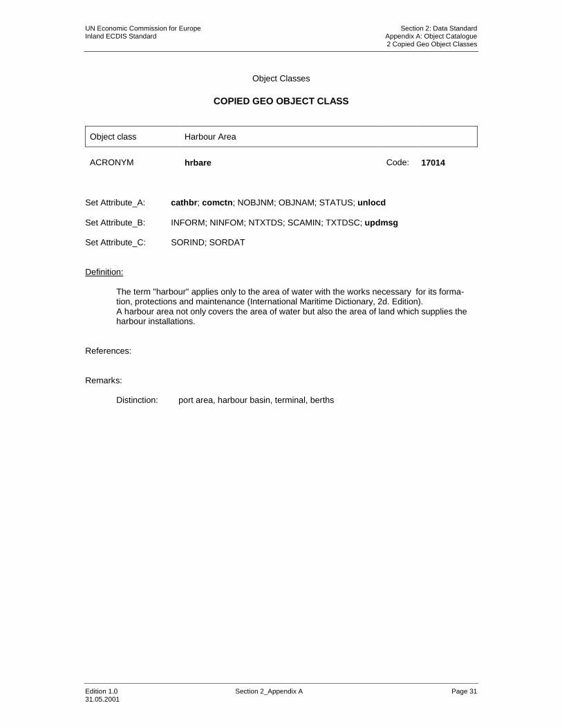
Object class Harbour Area
ACRONYM hrbare Code: 17014
Set Attribute_A: cathbr; comctn; NOBJNM; OBJNAM; STATUS; unlocd Set Attribute_B: INFORM; NINFOM; NTXTDS; SCAMIN; TXTDSC; updmsg Set Attribute_C: SORIND; SORDAT Definition:
The term "harbour" applies only to the area of water with the works necessary for its forma-tion, protections and maintenance (International Maritime Dictionary, 2d. Edition). A harbour area not only covers the area of water but also the area of land which supplies the harbour installations.
References: Remarks:
Distinction: port area, harbour basin, terminal, berths

UN Economic Commission for Europe Section 2: Data Standard Inland ECDIS Standard Appendix A: Object Catalogue 2 Copied Geo Object Classes
Edition 1.0 Section 2_Appendix A Page 32 31.05.2001
Object Classes
COPIED GEO OBJECT CLASS
Object class Harbour Facilities
ACRONYM hrbfac Code: 17015
Set Attribute_A: cathaf; CONDTN; DATEND; DATSTA; NATCON; NOBJNM; OBJNAM; PEREND;
PERSTA; STATUS; Set Attribute_B: INFORM; NINFOM; NTXTDS; SCAMIN; TXTDSC; updmsg Set Attribute_C: SORIND; SORDAT Definition:
A harbour installation with a service or commercial operation of public interest. References: Remarks:
Distinction: small craft facilities

UN Economic Commission for Europe Section 2: Data Standard Inland ECDIS Standard Appendix A: Object Catalogue 2 Copied Geo Object Classes
Edition 1.0 Section 2_Appendix A Page 33 31.05.2001
Object Classes
COPIED GEO OBJECT CLASS
Object class Lock Basin
ACRONYM lokbsn Code: 17016
Set Attribute_A: HORACC; horcll; horclw; HORLEN; HORWID; NOBJNM; OBJNAM;
STATUS; TIMEND; TIMSTA Set Attribute_B: INFORM; NINFOM; NTXTDS; SCAMIN; TXTDSC; updmsg Set Attribute_C: SORIND; SORDAT Definition: A lock basin is a wet dock in a waterway, permitting a ship to pass from one level to another (adapted from IHO Dictionary, S-32, 5th Edition, 2881) References: Remarks:
Distinction: Lock area, lock basin part

UN Economic Commission for Europe Section 2: Data Standard Inland ECDIS Standard Appendix A: Object Catalogue 2 Copied Geo Object Classes
Edition 1.0 Section 2_Appendix A Page 34 31.05.2001
Object Classes
COPIED GEO OBJECT CLASS
Object class Radio calling-in point
ACRONYM rdocal Code: 17017
Set Attribute_A: catcom; comctn; COMCHA; DATEND; DATSTA; NOBJNM; OBJNAM;
ORIENT; PEREND; PERSTA; STATUS; TRAFIC; Set Attribute_B: INFORM; NINFOM; NTXTDS; PICREP; SCAMIN; TXTDSC; updmsg Set Attribute_C: SORIND; SORDAT Definition:
Also called radio reporting points, they have been established in certain busy waterways and port approaches to assist traffic control. On passing these points or crossing a defined line ves-sels are required to report on VHF to a Traffic Control Centre. (adapted from IHO Chart Specifications, M-4):
References:
INT 1: IM 40; M-4: 488;
Remarks:
The attribute ‘orientation’ (ORIENT) encodes the orientation of the traffic flow at that point.
Distinction: radio station; pilot boarding place;

UN Economic Commission for Europe Section 2: Data Standard Inland ECDIS Standard Appendix A: Object Catalogue 2 Copied Geo Object Classes
Edition 1.0 Section 2_Appendix A Page 35 31.05.2001
Object Classes
COPIED GEO OBJECT CLASS
Object class Restricted area
ACRONYM resare Code: 17005
Set Attribute_A: CATREA; DATEND; DATSTA; NOBJNM; OBJNAM; PEREND; PERSTA;
restrn; STATUS; Set Attribute_B: INFORM; NINFOM; NTXTDS; PICREP; SCAMIN; TXTDSC; updmsg Set Attribute_C: SORIND; SORDAT Definition:
A specified area designated by an appropriate authority within which navigation is restricted in accordance with certain specified conditions. (adapted from IHO Dictionary, S-32, 5th Edition, 4366)
References:
INT 1: IL 3; IN 2.1-2, 20-22, 25-26, 31, 34; M-4: 431.4; 439.2-4; 441.8; 445.2; 448.1-2; 449.5; Remarks:
Distinction: anchorage area; cable area; caution area; dumping ground; depth area; fair-way; dredged area; deep water route; military practice area; pipeline area; swept area;
UN Economic Commission for Europe Section 2: Data Standard Inland ECDIS Standard Appendix A: Object Catalogue 2 Copied Geo Object Classes
Edition 1.0 Section 2_Appendix A Page 36 31.05.2001
Object Classes
COPIED GEO OBJECT CLASS
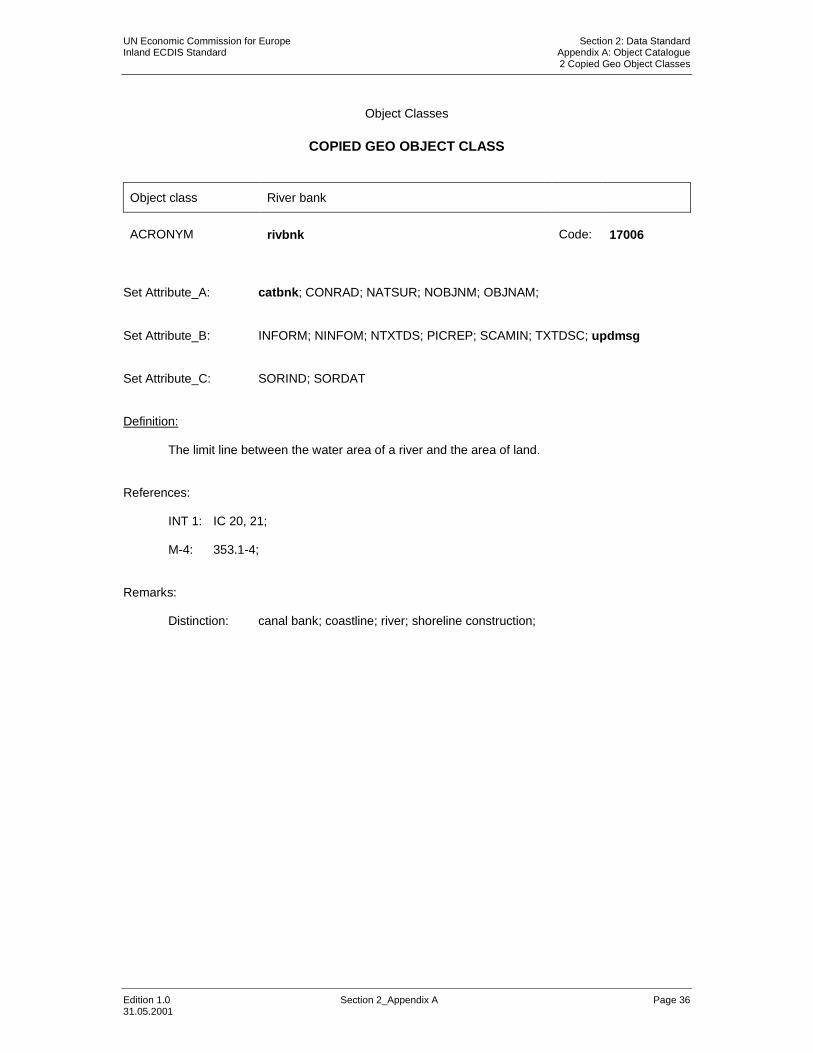
Object class River bank
ACRONYM rivbnk Code: 17006
Set Attribute_A: catbnk; CONRAD; NATSUR; NOBJNM; OBJNAM; Set Attribute_B: INFORM; NINFOM; NTXTDS; PICREP; SCAMIN; TXTDSC; updmsg Set Attribute_C: SORIND; SORDAT Definition:
The limit line between the water area of a river and the area of land. References:
INT 1: IC 20, 21; M-4: 353.1-4; Remarks:
Distinction: canal bank; coastline; river; shoreline construction;

UN Economic Commission for Europe Section 2: Data Standard Inland ECDIS Standard Appendix A: Object Catalogue 2 Copied Geo Object Classes
Edition 1.0 Section 2_Appendix A Page 37 31.05.2001
Object Classes
COPIED GEO OBJECT CLASS
Object class Signal station traffic
ACRONYM sistat Code: 17007
Set Attribute_A: catsit; COMCHA; DATEND; DATSTA; NOBJNM; OBJNAM; PEREND;
PERSTA; STATUS; Set Attribute_B: INFORM; NINFOM; NTXTDS; PICREP; SCAMIN; TXTDSC; updmsg Set Attribute_C: SORIND; SORDAT Definition:
A signal station is a place on shore from which signals are made to ships at sea. (IHO Diction-ary, S-32, 5th Edition, 4742) Traffic signal stations regulate the movement of traffic. (IHO Chart Specifications, M-4)
References:
INT 1: IT 21-25.2; M-4: 495.1-5; Remarks:
This object class is used to describe the function of the signal station rather than the structure on which the station is sited.
Distinction: signal station, warning;

UN Economic Commission for Europe Section 2: Data Standard Inland ECDIS Standard Appendix A: Object Catalogue 2 Copied Geo Object Classes
Edition 1.0 Section 2_Appendix A Page 38 31.05.2001
Object Classes
COPIED GEO OBJECT CLASS
Object class Signal station warning
ACRONYM sistaw Code: 17008
Set Attribute_A: catsiw; COMCHA; DATEND; DATSTA; NOBJNM; OBJNAM; PEREND; PERSTA; STATUS; Set Attribute_B: INFORM; NINFOM; NTXTDS; PICREP; SCAMIN; TXTDSC; updmsg
Set Attribute_C: SORIND; SORDAT Definition:
A signal station is a place on shore from which signals are made to ships at sea. (IHO Diction-ary, S-32, 5th Edition, 4742)
References:
INT 1: IT 20, 26, 28-36; M-4: 490.3; 494.1-2; 496.1-3; 497;
Remarks:
This object class is used to describe the function of the signal station rather than the structure on which the station is sited.
Distinction: signal station, traffic;

UN Economic Commission for Europe Section 2: Data Standard Inland ECDIS Standard Appendix A: Object Catalogue 2 Copied Geo Object Classes
Edition 1.0 Section 2_Appendix A Page 39 31.05.2001
Object Classes
COPIED GEO OBJECT CLASS
Object class Top Mark
ACRONYM topmar Code: 17009
Set Attribute_A: COLOUR; COLPAT; HEIGHT; marsys; STATUS; TOPSHP; VERACC;
verdat; VERLEN; Set Attribute_B: INFORM; NINFOM; NTXTDS; PICREP; SCAMIN; TXTDSC; updmsg Set Attribute_C: SORIND; SORDAT Definition:
A characteristic shape secured at the top of a buoy or beacon to aid in its identification. (IHO Dictionary, S-32, 5th Edition, 5548)
References:
INT 1: IQ 9; M-4: 463.1; Remarks:
The body carrying the topmark is a separate object.
Distinction: beacon, waterway; buoy, waterway

UN Economic Commission for Europe Section 2: Data Standard Inland ECDIS Standard Appendix A: Object Catalogue 3 Copied Meta Object Classes
Edition 1.0 Section 2_Appendix A Page 40 31.05.2001
Object Classes
COPIED META OBJECT CLASS
Object class Navigational system of marks
ACRONYM m_nsys Code: 17018
Set Attribute_A: marsys; ORIENT Set Attribute_B: INFORM; NINFOM; NTXTDS; SCAMIN; TXTDSC; updmsg Set Attribute_C: SORIND; SORDAT Definition:
An area within which a specific system of navigational marks applies and/or a common direction of buoyage.
References: INT 1: IQ 130-130.6; M-4: 461.1-4; Remarks:

UN Economic Commission for Europe Section 2: Data Standard Inland ECDIS Standard Appendix A: Object Catalogue 4 New Geo Object Classes
Edition 1.0 Section 2_Appendix A Page 41 31.05.2001
Object Classes
NEW GEO OBJECT CLASS
Object class Beacon water-way
ACRONYM bcnwtw Code: 17060
Set Attribute_A: BCNSHP; catwwm; COLOUR; COLPAT; CONDTN; CONRAD; CONVIS;
DATEND; DATSTA; ELEVAT; HEIGHT; marsys; NATCON; NOBJNM; OBJNAM; PEREND; PERSTA; STATUS; VERLEN;
Set Attribute_B: INFORM; NINFOM; NTXTDS; PICREP; SCAMIN; TXTDSC; updmsg Set Attribute_C: SORIND; SORDAT Definition:
A beacon is a prominent specially constructed object forming a conspicuous mark as a fixed aid to navigation or for use in hydrographic survey (IHO Dictionary, S-32, 5th Edition, 420). A beacon water way signs a river or canal itself or any obstructions in or at the river or canal.
References: Remarks:

UN Economic Commission for Europe Section 2: Data Standard Inland ECDIS Standard Appendix A: Object Catalogue 4 New Geo Object Classes
Edition 1.0 Section 2_Appendix A Page 42 31.05.2001
Object Classes
NEW GEO OBJECT CLASS
Object class Bridge area
ACRONYM brgare Code: 17053
Set Attribute_A: comctn; NOBJNM; OBJNAM Set Attribute_B: INFORM; NINFOM; NTXTDS; PICREP; SCAMIN; TXTDSC; updmsg Set Attribute_C: SORIND; SORDAT Definition:
A bridge area covers the entire area, in which the bridge itself and any bridge traffic regulations are located.
References: Remarks: Distinction: bridge, notmrk, TSRLPT

UN Economic Commission for Europe Section 2: Data Standard Inland ECDIS Standard Appendix A: Object Catalogue 4 New Geo Object Classes
Edition 1.0 Section 2_Appendix A Page 43 31.05.2001
Object Classes
NEW GEO OBJECT CLASS
Object class Bunker station
ACRONYM bunsta Code: 17054
Set Attribute_A: bunvss, catbun, comctn; NOBJNM; OBJNAM, TIMEND, TIMSTA Set Attribute_B: INFORM; NINFOM; NTXTDS; PICREP; SCAMIN; TXTDSC; updmsg Set Attribute_C: SORIND; SORDAT Definition: A station, at which a ship is able to bunker fuel, water or ballast References: Remarks:

UN Economic Commission for Europe Section 2: Data Standard Inland ECDIS Standard Appendix A: Object Catalogue 4 New Geo Object Classes
Edition 1.0 Section 2_Appendix A Page 44 31.05.2001
Object Classes
NEW GEO OBJECT CLASS
Object class Buoy water-way
ACRONYM boywtw Code: 17061
Set Attribute_A: BOYSHP; catwwm; COLOUR; COLPAT; CONDTN; CONRAD; CONVIS;
DATEND; DATSTA; ELEVAT; HEIGHT; marsys; NATCON; NOBJNM; OBJNAM; PEREND; PERSTA; STATUS; VERLEN;
Set Attribute_B: INFORM; NINFOM; NTXTDS; PICREP; SCAMIN; TXTDSC; updmsg Set Attribute_C: SORIND; SORDAT Definition:
A buoy is a floating object moored to the bottom in a particular place, as an aid to navigation or for other specific purposes. (IHO Dictionary S-32 5th Edition, 565). A buoy water way signs the fairway of a river or canal, any obstructions in the river or canal, turn offs, junctions, harbour entries or bridges.
References: Remarks:

UN Economic Commission for Europe Section 2: Data Standard Inland ECDIS Standard Appendix A: Object Catalogue 4 New Geo Object Classes
Edition 1.0 Section 2_Appendix A Page 45 31.05.2001
Object Classes
NEW GEO OBJECT CLASS
Object class Communication Area
ACRONYM comare Code: 17055
Set Attribute_A: catcom; COMCHA; DATEND; DATSTA; NOBJNM; OBJNAM; STATUS;
Set Attribute_B: INFORM; NINFOM; NTXTDS; SCAMIN; TXTDSC; updmsg Set Attribute_C: SORIND; SORDAT Definition:
Indicates the coverage of an area, in which a vessel has to report or may request information. References: Remarks:
Distinction:

UN Economic Commission for Europe Section 2: Data Standard Inland ECDIS Standard Appendix A: Object Catalogue 4 New Geo Object Classes
Edition 1.0 Section 2_Appendix A Page 46 31.05.2001
Object Classes
NEW GEO OBJECT CLASS
Object class Harbour Basin
ACRONYM hrbbsn Code: 17056
Set Attribute_A: HORACC; HORLEN; HORWID; NOBJNM; OBJNAM; STATUS; Set Attribute_B: INFORM; NINFOM; NTXTDS; SCAMIN; TXTDSC; updmsg Set Attribute_C: SORIND; SORDAT Definition:
An enclosed area of water surrounded by quay walls constructed to provide means for the transfer of cargos from and to ships (International Maritime Dictionary, 2d. Edtion).
References: Remarks:
Distinction: port area, harbour area, terminal, berths

UN Economic Commission for Europe Section 2: Data Standard Inland ECDIS Standard Appendix A: Object Catalogue 4 New Geo Object Classes
Edition 1.0 Section 2_Appendix A Page 47 31.05.2001
Object Classes
NEW GEO OBJECT CLASS
Object class Lock area
ACRONYM lokare Code: 17057
Set Attribute_A: comctn; NOBJNM; OBJNAM; STATUS; Set Attribute_B: INFORM; NINFOM; NTXTDS; PICREP; SCAMIN; TXTDSC; updmsg Set Attribute_C: SORIND; SORDAT Definition:
A lock area covers the entire area, in which the lock basins and any lock support are located. References: Remarks:
Distinction: Lock basin, lock basin part

UN Economic Commission for Europe Section 2: Data Standard Inland ECDIS Standard Appendix A: Object Catalogue 4 New Geo Object Classes
Edition 1.0 Section 2_Appendix A Page 48 31.05.2001
Object Classes
NEW GEO OBJECT CLASS
Object class Lock basin part
ACRONYM lkbspt Code: 17058
Set Attribute_A: HORACC; horcll; horclw; HORLEN; HORWID; NOBJNM; OBJNAM;
STATUS; TIMEND; TIMSTA Set Attribute_B: INFORM; NINFOM; NTXTDS; SCAMIN; TXTDSC; updmsg Set Attribute_C: SORIND; SORDAT Definition:
A lock basin is divided into several lock basin parts, if this lock basin has one ground level but several gates.
References: Remarks:
Distinction: Lock area, Lock basin

UN Economic Commission for Europe Section 2: Data Standard Inland ECDIS Standard Appendix A: Object Catalogue 4 New Geo Object Classes
Edition 1.0 Section 2_Appendix A Page 49 31.05.2001
Object Classes
NEW GEO OBJECT CLASS
Object class Notice mark
ACRONYM notmrk Code: 17050
Set Attribute_A: catnmk; fnctnm; dirimp; disipd; disipu; disbk1; disbk2; addmrk; marsys;
ORIENT; CONDTN; NOBJNM; OBJNAM; STATUS; Set Attribute_B: INFORM; NINFOM; NTXTDS; PICREP; SCAMIN; TXTDSC; updmsg Set Attribute_C: SORIND; SORDAT Definition:
to be amended References: Remarks: Distinction:
UN Economic Commission for Europe Section 2: Data Standard Inland ECDIS Standard Appendix A: Object Catalogue 4 New Geo Object Classes
Edition 1.0 Section 2_Appendix A Page 50 31.05.2001
Object Classes
NEW GEO OBJECT CLASS
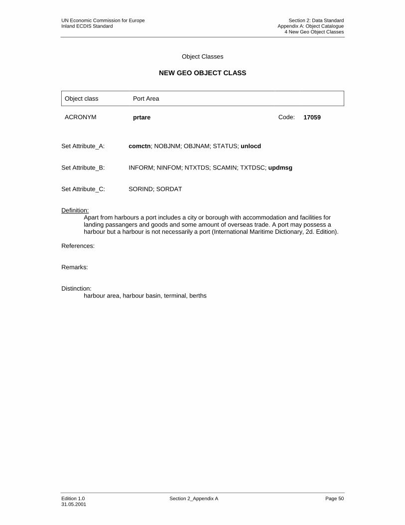
Object class Port Area
ACRONYM prtare Code: 17059
Set Attribute_A: comctn; NOBJNM; OBJNAM; STATUS; unlocd Set Attribute_B: INFORM; NINFOM; NTXTDS; SCAMIN; TXTDSC; updmsg Set Attribute_C: SORIND; SORDAT Definition:
Apart from harbours a port includes a city or borough with accommodation and facilities for landing passangers and goods and some amount of overseas trade. A port may possess a harbour but a harbour is not necessarily a port (International Maritime Dictionary, 2d. Edition).
References: Remarks: Distinction:
harbour area, harbour basin, terminal, berths

UN Economic Commission for Europe Section 2: Data Standard Inland ECDIS Standard Appendix A: Object Catalogue 4 New Geo Object Classes
Edition 1.0 Section 2_Appendix A Page 51 31.05.2001
Object Classes
NEW GEO OBJECT CLASS
Object class Refuse dump
ACRONYM refdmp Code: 17062
Set Attribute_A: catdmp; comctn; NOBJNM;OBJNAM, TIMEND, TIMSTA, Set Attribute_B: INFORM; NINFOM; NTXTDS; PICREP; SCAMIN; TXTDSC; updmsg Set Attribute_C: SORIND; SORDAT Definition: At a refuse dump ships are able to unload their refuse like waste oil or black water. References: Remarks:

UN Economic Commission for Europe Section 2: Data Standard Inland ECDIS Standard Appendix A: Object Catalogue 4 New Geo Object Classes
Edition 1.0 Section 2_Appendix A Page 52 31.05.2001
Object Classes
NEW GEO OBJECT CLASS
Object class Route planning point
ACRONYM rtplpt Code: 17063
Set Attribute_A: NOBJNM; OBJNAM; Set Attribute_B: INFORM; NINFOM; NTXTDS; PICREP; SCAMIN; TXTDSC; updmsg Set Attribute_C: SORIND; SORDAT Definition:
A route planning point describes the projection of a feature object onto the waterway axis. References: Remarks:
UN Economic Commission for Europe Section 2: Data Standard Inland ECDIS Standard Appendix A: Object Catalogue 4 New Geo Object Classes
Edition 1.0 Section 2_Appendix A Page 53 31.05.2001
Object Classes
NEW GEO OBJECT CLASS
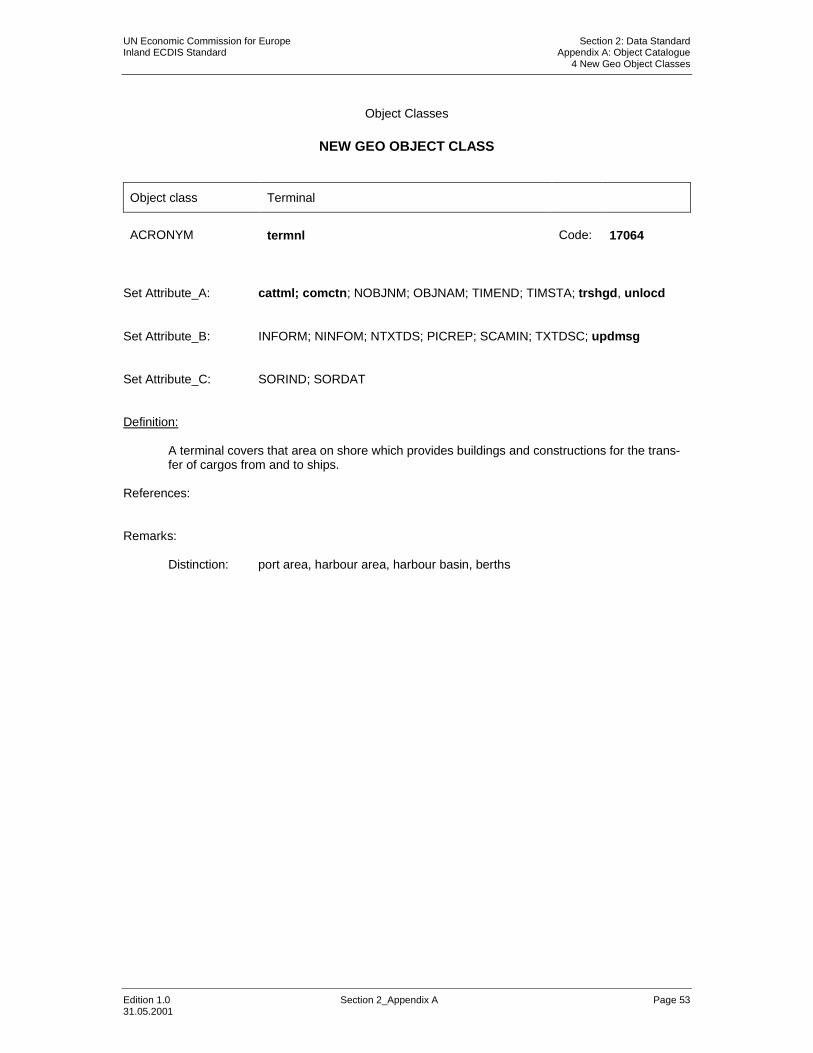
Object class Terminal
ACRONYM termnl Code: 17064
Set Attribute_A: cattml; comctn; NOBJNM; OBJNAM; TIMEND; TIMSTA; trshgd, unlocd Set Attribute_B: INFORM; NINFOM; NTXTDS; PICREP; SCAMIN; TXTDSC; updmsg Set Attribute_C: SORIND; SORDAT Definition:
A terminal covers that area on shore which provides buildings and constructions for the trans-fer of cargos from and to ships.
References: Remarks:
Distinction: port area, harbour area, harbour basin, berths

UN Economic Commission for Europe Section 2: Data Standard Inland ECDIS Standard Appendix A: Object Catalogue 4 New Geo Object Classes
Edition 1.0 Section 2_Appendix A Page 54 31.05.2001
Object Classes
NEW GEO OBJECT CLASS
Object class Turning basin
ACRONYM trnbsn Code: 17065
Set Attribute_A: HORCLR; NOBJNM;OBJNAM Set Attribute_B: INFORM; NINFOM; NTXTDS; PICREP; SCAMIN; TXTDSC; updmsg Set Attribute_C: SORIND; SORDAT Definition:
An area of water or enlargement of a channel used for turning vessels (International Maritime Dictionary, 2d Edition)
References: Remarks:

UN Economic Commission for Europe Section 2: Data Standard Inland ECDIS Standard Appendix A: Object Catalogue 4 New Geo Object Classes
Edition 1.0 Section 2_Appendix A Page 55 31.05.2001
Object Classes
NEW GEO OBJECT CLASS
Object class Waterway axis
ACRONYM wtwaxs Code: 17051
Set Attribute_A: catccl; NOBJNM; OBJNAM; Set Attribute_B: INFORM; NINFOM; NTXTDS; PICREP; SCAMIN; TXTDSC; updmsg Set Attribute_C: SORIND; SORDAT Definition:
The waterway axis can be defined by e.g: - the middle line of a fairway,
(Definition of fairway: That part of a river, harbour; etc. where the main navigable chan-nel for vessels of larger size lies. It is also the usual course followed by vessels entering or leaving harbours, called ‘ship channel’. (International Maritime Dictionary, 2nd Ed.)
- the middle line of a water way (Definition of waterway: The waterway covers the entire area of a river or canal)
References: Remarks: The object name indicates the specific name of a public waterway/or part of waterway.

UN Economic Commission for Europe Section 2: Data Standard Inland ECDIS Standard Appendix A: Object Catalogue 4 New Geo Object Classes
Edition 1.0 Section 2_Appendix A Page 56 31.05.2001
Object Classes
NEW GEO OBJECT CLASS
Object class Waterway profile
ACRONYM wtwprf Code: 17052
Set Attribute_A: wtwdis; HEIGHT; verdat Set Attribute_B: INFORM; NINFOM; NTXTDS; PICREP; SCAMIN; TXTDSC; updmsg Set Attribute_C: SORIND; SORDAT Definition:
A waterway profile is a physically non-existent line which is normally the connection of two op-posite distance marks. Waterway profiles can be used to define a special water level.
References: Remarks:

UN Economic Commission for Europe Section 2: Data Standard Inland ECDIS Standard Appendix A: Object Catalogue 5 Copied object attributes
Edition 1.0 Section 2_Appendix A Page 57 31.05.2001
Attributes
COPIED OBJECT ATTRIBUTES
Attribute Category of Anchorage area
ACRONYM catach Code: 17000
Attribute type: L Expected input:
ID Meaning
1: unrestricted anchorage 2: deep water anchorage IN 12.4; 431.3; 3: tanker anchorage IN 12.5; 431.3; 4: explosives anchorage IN 12.7; 431.3; 5: quarantine anchorage IN 12.8; 431.3; 6: sea-plane anchorage IN 14; 449.6; 7: small craft anchorage 8: small craft mooring area IQ 44; 431.7; 9: anchorage for periods up to 24 hours IN 12.6; 431.3; 10: push tow anchorage 11: anchorage for other vessels than push tows 12: anchorage for other vessels than dangerous
cargo vessels Definitions: References: Remarks:

UN Economic Commission for Europe Section 2: Data Standard Inland ECDIS Standard Appendix A: Object Catalogue 5 Copied object attributes
Edition 1.0 Section 2_Appendix A Page 58 31.05.2001
Attributes
COPIED OBJECT ATTRIBUTES
Attribute Category of bridge
ACRONYM catbrg Code: 17006
Attribute type: L Expected input:
ID Meaning
1: fixed bridge ID 22 2: opening bridge ID 23.1 3: swing bridge ID 23.2 4: lifting bridge ID 23.3 5: bascule bridge ID 23.4 6: pontoon bridge ID 23.5 7: draw bridge ID 23.6 8: transporter bridge ID 24 9: footbridge 10: viaduct 11: aqueduct 12: suspension bridge
Definitions: References: Remarks:

UN Economic Commission for Europe Section 2: Data Standard Inland ECDIS Standard Appendix A: Object Catalogue 5 Copied object attributes
Edition 1.0 Section 2_Appendix A Page 59 31.05.2001
Attributes
COPIED OBJECT ATTRIBUTES
Attribute Category of distance mark
ACRONYM catdis Code: 17001
Attribute type: E Expected input:
ID Meaning
1: distance mark not physically installed IF 40; 2: visible mark, pole IF 40; 3: visible mark, board IF 40; 4: visible mark, unknown shape IF 40; 5: kilometre mark, waterway bank 6: hectometre mark, waterway bank 7: kilometre mark, waterway axis 8: hectometre mark, waterway axis
Definitions: References: Remarks:

UN Economic Commission for Europe Section 2: Data Standard Inland ECDIS Standard Appendix A: Object Catalogue 5 Copied object attributes
Edition 1.0 Section 2_Appendix A Page 60 31.05.2001
Attributes
COPIED OBJECT ATTRIBUTES
Attribute Category of ferry
ACRONYM catfry Code: 17007
Attribute type: L Expected input: ID Meaning INT 1
1: ‘free-moving’ ferry IM 50 2: cable ferry IM 51 3: ice ferry 4: swinging wire ferry
Definitions: References: Remarks:
The attribute `category of ferry` does not encode the various types of ferry vessel, but the ma-noeuvrability of the ferry. The value `cable ferry` indicates a ferry that follows a fixed route guided by a cable. A cable ferry may hinder the flow of other traffic.

UN Economic Commission for Europe Section 2: Data Standard Inland ECDIS Standard Appendix A: Object Catalogue 5 Copied object attributes
Edition 1.0 Section 2_Appendix A Page 61 31.05.2001
Attributes
COPIED OBJECT ATTRIBUTES
Attribute Category of harbour facilities
ACRONYM cathaf Code: 17008
Attribute type: L Expected input:
ID Meaning
1-3: deleted values (see new object class termnl) 4-5 deleted values (see new object class hrbare) 6 naval base 7-8 deleted values (see new object class termnl) 9: ship yard 10-11: deleted values (see new object class termnl) 12: harbour master’s office IF60 13: pilot office 14: water-police office 15: customs office IF61 16: service and repair 17: quarantine station IF62.1
Definitions: References: Remarks:

UN Economic Commission for Europe Section 2: Data Standard Inland ECDIS Standard Appendix A: Object Catalogue 5 Copied object attributes
Edition 1.0 Section 2_Appendix A Page 62 31.05.2001
Attributes
COPIED OBJECT ATTRIBUTES
Attribute Category of signal station traffic
ACRONYM catsit Code: 17002
Attribute type: L Expected input:
ID Meaning INT1
1: port control IT 23; 2: port entry and departure 3: International Port Traffic IT 21 4: berthing 5: dock 6: lock IT 24 7: flood barrage 8: bridge passage IT 25.1 9: dredging 10: oncoming traffic indication
Definitions: References: Remarks:

UN Economic Commission for Europe Section 2: Data Standard Inland ECDIS Standard Appendix A: Object Catalogue 5 Copied object attributes
Edition 1.0 Section 2_Appendix A Page 63 31.05.2001
Attributes
COPIED OBJECT ATTRIBUTES
Attribute Category of signal station warning
ACRONYM catsiw Code: 17003
Attribute type: L Expected input:
ID Meaning INT1
1: danger IT 35 2: maritime obstruction 3: cable 4: military practice IT 36 5: distress IT 26 6: weather IT 29 7: storm IT 28 8: ice IT 30 9: time IT 31 10: tide IT 33 11: tidal stream IT 34 12: tide gauge IT 32.2 13: tide scale IT 32.1 14: diving 15: high water mark 16: vertical clearance indication 17: over/under vertical clearance indication 18: depth indication
Definitions: References: Remarks:

UN Economic Commission for Europe Section 2: Data Standard Inland ECDIS Standard Appendix A: Object Catalogue 5 Copied object attributes
Edition 1.0 Section 2_Appendix A Page 64 31.05.2001
Attributes
COPIED OBJECT ATTRIBUTES
Attribute Marks navigational – System of
ACRONYM marsys Code: 17009
Attribute type: E Expected input:
ID Meaning INT1
1: IALA A IQ 130 2: IALA B IQ130 9: no system 10: other system 11: EU Inland waterway
Definition: to be amended Remarks:
UN Economic Commission for Europe Section 2: Data Standard Inland ECDIS Standard Appendix A: Object Catalogue 5 Copied object attributes
Edition 1.0 Section 2_Appendix A Page 65 31.05.2001
Attributes
COPIED OBJECT ATTRIBUTES
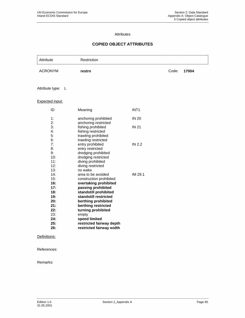
Attribute Restriction
ACRONYM restrn Code: 17004
Attribute type: L Expected input:
ID Meaning INT1
1: anchoring prohibited IN 20 2: anchoring restricted 3: fishing prohibited IN 21 4: fishing restricted 5: trawling prohibited 6: trawling restricted 7: entry prohibited IN 2.2 8: entry restricted 9: dredging prohibited 10: dredging restricted 11: diving prohibited 12: diving restricted 13: no wake 14: area to be avoided IM 29.1 15: construction prohibited 16: overtaking prohibited 17: passing prohibited 18: standstill prohibited 19: standstill restricted 20: berthing prohibited 21: berthing restricted 22: turning prohibited 23: empty 24: speed limited 25: restricted fairway depth 26: restricted fairway width
Definitions: References: Remarks:

UN Economic Commission for Europe Section 2: Data Standard Inland ECDIS Standard Appendix A: Object Catalogue 5 Copied object attributes
Edition 1.0 Section 2_Appendix A Page 66 31.05.2001
Attributes
COPIED OBJECT ATTRIBUTES
Attribute Vertical datum
ACRONYM verdat Code: 17005
Attribute type: E Expected input:
ID : Meaning … 30. Equivalent height of water (German GlW) 31. Highest Shipping Height of Water (German HSW) 32. Amsterdam Ordinance Datum (NAP) 33. current waterlevel Definition: to be amended References: to be amended Remarks:

UN Economic Commission for Europe Section 2: Data Standard Inland ECDIS Standard Appendix A: Object Catalogue 6 New object attributes
Edition 1.0 Section 2_Appendix A Page 67 31.05.2001
Attributes
NEW OBJECT ATTRIBUTES
Attribute Additional mark
ACRONYM addmrk Code: 17050
Attribute type: L Expected input:
ID: Meaning 1: top (board) 2: bottom (board) 3: right (triangle to the right) 4: left (triangle to the left)
Definition: The kind and location of an additional mark at a notice mark References: Remarks: Distinction: notmrk

UN Economic Commission for Europe Section 2: Data Standard Inland ECDIS Standard Appendix A: Object Catalogue 6 New object attributes
Edition 1.0 Section 2_Appendix A Page 68 31.05.2001
Attributes
NEW OBJECT ATTRIBUTES
Attribute Bunker vessel, availability
ACRONYM bunves Code: 17065
Attribute type: E Expected input:
ID: Meaning
1: bunker vessel available 2: no bunker vessel available
Definition: The availability of a bunker vessel at a bunker station References: Remarks:

UN Economic Commission for Europe Section 2: Data Standard Inland ECDIS Standard Appendix A: Object Catalogue 6 New object attributes
Edition 1.0 Section 2_Appendix A Page 69 31.05.2001
Attributes
NEW OBJECT ATTRIBUTES
Attribute Category of bank
ACRONYM catbnk Code: 17051
Attribute type: E Expected input:
ID: Meaning
1: steep bank 2: flat bank 3: embankment, fastened 4: embankment, unfastened
Definition: References: Remarks:

UN Economic Commission for Europe Section 2: Data Standard Inland ECDIS Standard Appendix A: Object Catalogue 6 New object attributes
Edition 1.0 Section 2_Appendix A Page 70 31.05.2001
Attributes
NEW OBJECT ATTRIBUTES
Attribute Category of berth
ACRONYM catbrt Code: 17066
Attribute type: L Expected input:
ID: Meaning
1: loading 2: unloading 3: overnight accommodation
Definition: References: Remarks: Distinction: transshipment goods

UN Economic Commission for Europe Section 2: Data Standard Inland ECDIS Standard Appendix A: Object Catalogue 6 New object attributes
Edition 1.0 Section 2_Appendix A Page 71 31.05.2001
Attributes
NEW OBJECT ATTRIBUTES
Attribute Category of bunker station
ACRONYM catbun Code: 17067
Attribute type: L Expected input:
ID Meaning
1: diesel oil 2: water 3: ballast
Definitions: References: Remarks:

UN Economic Commission for Europe Section 2: Data Standard Inland ECDIS Standard Appendix A: Object Catalogue 6 New object attributes
Edition 1.0 Section 2_Appendix A Page 72 31.05.2001
Attributes
NEW OBJECT ATTRIBUTES
Attribute Category of CEMT class
ACRONYM catccl Code: 17068
Attribute type: L Expected input:
ID Meaning
1: 0 small vessels and pleasure craft 2: I peniche 3: II campine barge 4: III Dortmund-Ems barge 5: IV Rhine-Herne barge 6: Va Large Rhine barge; 1-barge push-tow unit 7: Vb 2-barge push-tow unit; long formation 8: VIa 2-barge push-tow unit; wide formation 9: VIb 4-barge push-tow unit 10: VIc 6-barge push-tow unit 11: No CEMT class
Definitions: References: Remarks:

UN Economic Commission for Europe Section 2: Data Standard Inland ECDIS Standard Appendix A: Object Catalogue 6 New object attributes
Edition 1.0 Section 2_Appendix A Page 73 31.05.2001
Attributes
NEW OBJECT ATTRIBUTES
Attribute Category of communication
ACRONYM catcom Code: 17069
Attribute type: L Expected input:
ID Meaning
1: VTS centre 2: VTS sector 3: IVS point 4: MID 5: Lock 6: Bridge 7: custom
Definitions: References: Remarks:

UN Economic Commission for Europe Section 2: Data Standard Inland ECDIS Standard Appendix A: Object Catalogue 6 New object attributes
Edition 1.0 Section 2_Appendix A Page 74 31.05.2001
Attributes
NEW OBJECT ATTRIBUTES
Attribute Category of harbour area
ACRONYM cathbr Code: 17070
Attribute type: L Expected input:
ID Meaning
1: custom harbour 2: port of refuge 3: yacht harbour/marina 4: fishing harbour 5: private harbour
Definitions: References: Remarks:

UN Economic Commission for Europe Section 2: Data Standard Inland ECDIS Standard Appendix A: Object Catalogue 6 New object attributes
Edition 1.0 Section 2_Appendix A Page 75 31.05.2001
Attributes
NEW OBJECT ATTRIBUTES
Attribute Category of notice mark
ACRONYM catnmk Code: 17052
Attribute type: E Expected input:
ID : Meaning 1: entry prohibited, (A.1) 2: entry prohibited, but smallcraft boats without engine permitted, (A.1a) 3: overtaking prohibited, (A.2) 4: overtaking between push tows and towing units prohibited, (A.3) 5: no passing and overtaking, (A.4) 6: mooring prohibited, (A.5) 7: mooring prohibited, with distance from the bank, (A.5.1) 8: anchoring prohibited, (A.6) 9: berthing prohibited, (A.7) 10: turning prohibited, (A.8) 11: avoid wave wash, (A.9) 12: passing on left side prohibited, (A.10) 13: passing on right side prohibited, (A.10) 14: boats with engine prohibited, (A.12) 15: sport and pleasure boats prohibited, (A.13) 16: waterskiing prohibited, (A.14) 17: sailing boats prohibited, (A.15) 18: boats without engines or sails prohibited, (A.16) 19: windsurfing prohibited, (A.17) 20: waterscooters and jetskis prohibited, (A.20) 21: highspeed motorboats prohibited (A.18) 22: slipping of boats prohibited, (A.19) 23: mandatory traffic direction, left, (B.1) 24: mandatory traffic direction, right, (B.1) 25: mandatory change of the fairwayside to port, (B.2a) 26: mandatory change of the fairwayside to starboard, (B.2b) 27: port fairwayside is mandatory traffic direction, (B.3a) 28: starboard fairwayside is mandatory traffic direction, (B.3b) 29: mandatory crossing of the fairwayside to port, (B.4a) 30: mandatory crossing of the fairwayside to starboard, (B.4b) 31: mandatory stop, (B.5) 32: maximum speed limit, (B.6) 33: mandatory sound signal, (B.7) 34: special attention, (B.8) 35: give way to other vessels when entering the main fairway, (B.9a) 36: give way to other vessels when crossing the main fairway, (B.9b 37: mandatory radiophone, (B.11) 38: restricted fairway depth, (C.1)

UN Economic Commission for Europe Section 2: Data Standard Inland ECDIS Standard Appendix A: Object Catalogue 6 New object attributes
Edition 1.0 Section 2_Appendix A Page 76 31.05.2001
39: restricted vertical clearance, (C.2) 40: restricted width of the fairway or passage, (C.3) 41: general restrictions (with additional sign), (C.4) 42: restricted width of the waterway at the left bank, (C.5) 43: restricted width of the waterway at the right bank, (C.5) 44: recommended passage for both directions, (D.1a) 45: recommended passage for only one direction, (D.1b) 46: recommended passage on right side, (D.2) 47: recommended passage on left side, (D.2) 48: recommended traffic direction, left; (D.3) 49: recommended traffic direction, right, (D.3) 50: entry permitted, (E.1) 51: overhead power line crossing, (E.2) 52: weir, (E.3) 53: cable ferry, (E.4) 54: ferry, (E.4b) 55: mooring permitted, (E.5) 56: mooring permitted, with distance, (E.5.1) 57: mooring permitted, between two distances, (E.5.2) 58: maximum number of vessels laying side by side, (E.5.3) 59: mooring facilities for push tows, (E.5.4) 60: mooring facilities for push tows with one blue cone, (E.5.5) 61: mooring facilities for push tows with two blue cones, (E.5.6) 62: mooring facilities for push tows with three blue cones, (E.5.7) 63: mooring facilities for other vessels than push tows, (E.8) 64: mooring facilities for other vessels than push tows with one blue cone,
(E.5.9) 65: mooring facilities for other vessels than push tows with two blue cones,
(E.5.10) 66: mooring facilities for other vessels than push tows with three blue
cones, (E.5.11) 67: mooring facilities for all vessels (E.5.12) 68: mooring facilities for all vessels with one blue cone, (E.5.13) 69: mooring facilities for all vessels with two blue cones, (E.5.14) 70: mooring facilities for all vessels with three blue cones, (E.5.15) 71: anchoring permitted, (E.6) 72: berthing permitted, (E.7) 73: facilities for transfer of vehicles, (E.7.1.) 74: turning permitted, (E.8) 75: crossing with secondary waterway ahead, (E.9a) 76: secondary waterway ahead on the right, (E.9b) 77: secondary waterway ahead on the left, (E.9c) 78: secondary waterway ahead (main waterway right), (E.9d) 79: secondary waterway ahead (main waterway left), (E.9e) 80: secondary waterway left (main waterway right), (E.9f) 81: secondary waterway right (main waterway left) (E.9g) 82: secondary waterway ahead and left (main waterway right), (E.9h) 83: secondary waterway ahead and right (main waterway left), (E.9i) 84: crossing with main waterway ahead, (E.10a) 85: junction with main waterway ahead, (E.10b) 86: junction with main waterway ahead and right, (E.10.c) 87: junction with main waterway ahead and left, (E.10d) 88: junction with main waterway ahead and right (secondary waterway left),
(E.10e) 89: junction with main waterway ahead and left (secondary waterway right),
(E.10f) 90: end of prohibition or regulation, (E.11)

UN Economic Commission for Europe Section 2: Data Standard Inland ECDIS Standard Appendix A: Object Catalogue 6 New object attributes
Edition 1.0 Section 2_Appendix A Page 77 31.05.2001
91: drink water (E.13) 92: telephone (E.14) 93: boats with engine permitted (E.15) 94: sport and pleasure boats permitted, (E.16) 95: waterski area, (E.17) 96: sailing boats permitted, (E.18) 97: boats without engine or sails permitted, (E.19) 98: windsurfing permitted, (E.20) 99: nautical radio information, (E.23) 100: waterscooters, jetskis permitted, (E.24) 101: high speed motorboats permitted, (E.21) 102: slipping of boats permitted, (E.22)
Definition: References: All order numbers are referenced to CEVNI (European Code for Inland Waterways)
revision 2, edited by the Economic Commission for Europe of the United Nations, 2001.
Remarks:

UN Economic Commission for Europe Section 2: Data Standard Inland ECDIS Standard Appendix A: Object Catalogue 6 New object attributes
Edition 1.0 Section 2_Appendix A Page 78 31.05.2001
Attributes
NEW OBJECT ATTRIBUTES
Attribute Category of refuse dump
ACRONYM catrfd Code: 17071
Attribute type: L Expected input:
ID Meaning
1: cargo residue/slop 2: waste oil 3: gray/black water 4: domestic refuse
Definitions: References: Remarks:

UN Economic Commission for Europe Section 2: Data Standard Inland ECDIS Standard Appendix A: Object Catalogue 6 New object attributes
Edition 1.0 Section 2_Appendix A Page 79 31.05.2001
Attributes
NEW OBJECT ATTRIBUTES
Attribute Category of terminal
ACRONYM cattml Code: 17072
Attribute type: L Expected input:
ID Meaning INT1
1: Passenger terminal 2: Ferry terminal IF10 3: Tansshipment terminal 4: RoRo terminal
Definitions:
A terminal provides facilities for handling particular forms of cargo (IHO Dictionary, S-32, 5th Edition, 5343).
References: Remarks: Distinction: transshipment goods

UN Economic Commission for Europe Section 2: Data Standard Inland ECDIS Standard Appendix A: Object Catalogue 6 New object attributes
Edition 1.0 Section 2_Appendix A Page 80 31.05.2001
Attributes
NEW OBJECT ATTRIBUTES
Attribute Category of waterway mark (buoy, beacon)
ACRONYM catwwm Code: 17112
Attribute type: E Expected input:
ID : Meaning 1: right side 2: left side 3: separation 4: right fairway side 5: left fairway side 6: fairway separation 7: fairway at the right side 8: fairway at the left side 9: fairway change to the right side 10: fairway change to the left side 11: obstruction at the right side 12: obstruction at the left side 13: turn off at the right side 14: turn off at the left side 15: junction at the right side 16: junction at the left side 17: harbour entry at the right side 18: harbour entry at the left side 19: bridge mark
Definition: References: This list is referenced to the German Rheinschiffahrts-Polizeiverordnung
(RheinSchPV) and Wasserstraßen-Verkehrsordnung (WVO) of Republic of Austria. Remarks:

UN Economic Commission for Europe Section 2: Data Standard Inland ECDIS Standard Appendix A: Object Catalogue 6 New object attributes
Edition 1.0 Section 2_Appendix A Page 81 31.05.2001
Attributes
NEW OBJECT ATTRIBUTES
Attribute Class of dangerous cargo
ACRONYM clsdng Code: 17055
Attribute type: E Expected input:
ID : Meaning 1 : one blue light/cone 2 : two blue lights/cones 3 : three blue lights/cones
Definition: References: Remarks:

UN Economic Commission for Europe Section 2: Data Standard Inland ECDIS Standard Appendix A: Object Catalogue 6 New object attributes
Edition 1.0 Section 2_Appendix A Page 82 31.05.2001
Attributes
NEW OBJECT ATTRIBUTES
Attribute Communication
ACRONYM comctn Code: 17073
Attribute type: S Expected input: all kinds of communication, e.g. phone or fax number, email, address etc.
Definition: References: Remarks:

UN Economic Commission for Europe Section 2: Data Standard Inland ECDIS Standard Appendix A: Object Catalogue 6 New object attributes
Edition 1.0 Section 2_Appendix A Page 83 31.05.2001
Attributes
NEW OBJECT ATTRIBUTES
Attribute Direction of impact
ACRONYM dirimp Code: 17056
Attribute type: L Expected input:
ID : Meaning 1 : upstream 2 : downstream 3 : to the left bank 4 : to the right bank
Definition: Direction of the impact of an area, which is signed by notice marks. References: Remarks:

UN Economic Commission for Europe Section 2: Data Standard Inland ECDIS Standard Appendix A: Object Catalogue 6 New object attributes
Edition 1.0 Section 2_Appendix A Page 84 31.05.2001
Attributes
NEW OBJECT ATTRIBUTES
Attribute Distance from bank, first
ACRONYM disbk1 Code: 17057
Attribute type: F Definition:
Minimum distance of the impact of an area, which is signed by notice marks. The distance is measured from the notice mark rectangular to the bank.
References: Minimum value: 0 Indication: Unit: defined in the HUNI subfield of the DSPM record or in the HUNITS attribute of the M_UNIT meta object class, e.g. metre (m) Resolution: 1 metre Format: xx Example: 30 Remarks:

UN Economic Commission for Europe Section 2: Data Standard Inland ECDIS Standard Appendix A: Object Catalogue 6 New object attributes
Edition 1.0 Section 2_Appendix A Page 85 31.05.2001
Attributes
NEW OBJECT ATTRIBUTES
Attribute Distance from bank, second
ACRONYM disbk2 Code: 17058
Attribute type: F Definition:
Maximum distance of the impact of an area, which is signed by notice marks. The distance is measured from the notice mark rectangular to the bank.
References: Minimum value: 0 Indication:
Unit: defined in the HUNI subfield of the DSPM record or in the HUNITS attribute of the M_UNIT meta object class, e.g. metre (m)
Resolution: 1 metre Format: xx Example: 50 Remarks:

UN Economic Commission for Europe Section 2: Data Standard Inland ECDIS Standard Appendix A: Object Catalogue 6 New object attributes
Edition 1.0 Section 2_Appendix A Page 86 31.05.2001
Attributes
NEW OBJECT ATTRIBUTES
Attribute Distance of impact, upstream
ACRONYM disipu Code: 17059
Attribute type: F Definition:
Upstream distance of the impact of an area, which is signed by notice marks. The distance is normally given on an additional mark left and/or right of the notice mark.
References: Minimum value: 0 Indication:
Unit: defined in the HUNI subfield of the DSPM record or in the HUNITS attribute of the M_UNIT meta object class, e.g. metre (m)
Resolution: 1 metre Format: xxx Example: 100 Remarks:

UN Economic Commission for Europe Section 2: Data Standard Inland ECDIS Standard Appendix A: Object Catalogue 6 New object attributes
Edition 1.0 Section 2_Appendix A Page 87 31.05.2001
Attributes
NEW OBJECT ATTRIBUTES
Attribute Distance of impact, downstream
ACRONYM disipd Code: 17060
Attribute type: F Definition:
Downstream distance of the impact of an area, which is signed by notice marks. The distance is normally given on an additional mark left and/or right of the notice mark.
References: Minimum value: 0 Indication:
Unit: defined in the HUNI subfield of the DSPM record or in the HUNITS attribute of the M_UNIT meta object class, e.g. metre (m)
Resolution: 1 metre Format: xxx Example: 100 Remarks:

UN Economic Commission for Europe Section 2: Data Standard Inland ECDIS Standard Appendix A: Object Catalogue 6 New object attributes
Edition 1.0 Section 2_Appendix A Page 88 31.05.2001
Attributes
NEW OBJECT ATTRIBUTES
Attribute Elevation 1
ACRONYM eleva1 Code: 17061
Attribute type: F Definition: Elevation 1 of a depth area References: Minimum value: 0.00 Indication:
Unit: defined in the HUNI subfield of the DSPM record or in the HUNITS attribute of the M_UNIT meta object class, e.g. metre (m)
Resolution: 0.01 metre Format: xxx.xx Example: 12.34 Remarks:

UN Economic Commission for Europe Section 2: Data Standard Inland ECDIS Standard Appendix A: Object Catalogue 6 New object attributes
Edition 1.0 Section 2_Appendix A Page 89 31.05.2001
Attributes
NEW OBJECT ATTRIBUTES
Attribute Elevation 2
ACRONYM eleva2 Code: 17062
Attribute type: F Definition: Elevation 2 of a depth area References: Minimum value: 0.00 Indication:
Unit: defined in the HUNI subfield of the DSPM record or in the HUNITS attribute of the M_UNIT meta object class, e.g. metre (m)
Resolution: 0.01 metre Format: xxx.xx Example: 12.34 Remarks:

UN Economic Commission for Europe Section 2: Data Standard Inland ECDIS Standard Appendix A: Object Catalogue 6 New object attributes
Edition 1.0 Section 2_Appendix A Page 90 31.05.2001
Attributes
NEW OBJECT ATTRIBUTES
Attribute Function of notice mark
ACRONYM fnctnm Code: 17063
Attribute type: E Expected input:
ID : Meaning 1 : prohibition mark 2 : regulation mark 3 : restriction mark 4 : recommendation mark 5 : information mark
Definition: References: Remarks:

UN Economic Commission for Europe Section 2: Data Standard Inland ECDIS Standard Appendix A: Object Catalogue 6 New object attributes
Edition 1.0 Section 2_Appendix A Page 91 31.05.2001
Attributes
NEW OBJECT ATTRIBUTES
Attribute Horizontal clearance, length
ACRONYM horcll Code: 17074
Attribute type: F Definition: The length of an object, such as a lock or basin, which is available for safe navigation. This may, or may not, be the same as the total physical length (HORLEN) of the object References: Minimum value: 0 Indication:
Unit: defined in the HUNI subfield of the DSPM record or in the HUNITS attribute of the M_UNIT meta object class, e.g. metre (m)
Resolution: 0.1 metres Format: xxx.x Example: 125.1 for a width of 125.1 metres. Remarks: Distinction: HORLEN

UN Economic Commission for Europe Section 2: Data Standard Inland ECDIS Standard Appendix A: Object Catalogue 6 New object attributes
Edition 1.0 Section 2_Appendix A Page 92 31.05.2001
Attributes
NEW OBJECT ATTRIBUTES
Attribute Horizontal clearance, width
ACRONYM horclw Code: 17075
Attribute type: F Definition: The width of an object, such as a lock or basin, which is available for safe navigation. This may, or may not, be the same as the total physical width (HORWID) of the object. References: Minimum value: 0 Indication:
Unit: defined in the HUNI subfield of the DSPM record or in the HUNITS attribute of the M_UNIT meta object class, e.g. metre (m)
Resolution: 0.1 metres Format: xxx.x Example: 125.1 for a width of 125.1 metres. Remarks: Distinction: HORWID

UN Economic Commission for Europe Section 2: Data Standard Inland ECDIS Standard Appendix A: Object Catalogue 6 New object attributes
Edition 1.0 Section 2_Appendix A Page 93 31.05.2001
Attributes
NEW OBJECT ATTRIBUTES
Attribute Transshipping goods
ACRONYM trshgd Code: 17076
Attribute type: L Expected input:
ID: Meaning
1: containers 2: bulk goods 3: oil 4: fuel 5: chemicals 6: liquid goods 7: explosive goods 8: fish 9: cars 10: general cargo
Definition: The kind of goods which are transferred from and to ships References: Remarks:

UN Economic Commission for Europe Section 2: Data Standard Inland ECDIS Standard Appendix A: Object Catalogue 6 New object attributes
Edition 1.0 Section 2_Appendix A Page 94 31.05.2001
Attributes
NEW OBJECT ATTRIBUTES
Attribute UN Location Code
ACRONYM unlocd Code: 17077
Attribute type: S Definition:
For locations the UN CEFACT Recommendation 16 (UN LOCODE - unique
identification of locations and harbours) is proposed for use wherever possible
for places and harbours.
For terminals 5 digits are added to identify the terminals within a harbour.
References:
The UN locodes can be obtained from the Internet (www.unece.org/locode).
The terminal codes are available at Bureau Telematica in the Netherlands
Indication:
Format:
UN LOCODE: Alphanumeric, 5 digits
Terminal code: Alphanumeric, 5 digits, always in combination with UN-
LOCODE
Example:
UN LOCODE of Bingen: DEBIN
UN LOCODE and terminal code of ECT Duisburg: DEDUIECTDU
Remarks:

UN Economic Commission for Europe Section 2: Data Standard Inland ECDIS Standard Appendix A: Object Catalogue 6 New object attributes
Edition 1.0 Section 2_Appendix A Page 95 31.05.2001
Attributes
NEW OBJECT ATTRIBUTES
Attribute Update message
ACRONYM updmsg Code: 40000
Attribute type: S Expected input: Definitions: Textual update information about an object References: Remarks:
The attribute `update message` can be used to inform the mariner about the reason for an up-date or special warnings referring to the object.

UN Economic Commission for Europe Section 2: Data Standard Inland ECDIS Standard Appendix A: Object Catalogue 6 New object attributes
Edition 1.0 Section 2_Appendix A Page 96 31.05.2001
Attributes
OBJECT ATTRIBUTES
Attribute National update message
ACRONYM nupdms Code: 40020
Attribute type: S Expected input: Definitions: Textual update information about an object in national language References: Remarks:
The attribute `update message` can be used to inform the mariner about the reason for an up-date or special warnings referring to the object.

UN Economic Commission for Europe Section 2: Data Standard Inland ECDIS Standard Appendix A: Object Catalogue 6 New object attributes
Edition 1.0 Section 2_Appendix A Page 97 31.05.2001
Attributes
NEW OBJECT ATTRIBUTES
Attribute Waterway distance
ACRONYM wtwdis Code: 17064
Attribute type: F Definition: The distance measured from an origin of a river or canal. References: Minimum value: 0 Indication:
Unit: kilometres Resolution: 0.1 Format: xxx.x Example: 523.4 for a waterway distance of 523.4 km. Remarks:

UN Economic Commission for Europe Section 2: Data Standard Inland ECDIS Standard Appendix A: Object Catalogue 7 Overwiew of used Inland ECDIS object classes and attributes
Edition 1.0 Section 2_Appendix A Page 98 31.05.2001
7 Overview of Inland ECDIS Object Classes and Attributes
Object class description Acronym Code Page Anchor berth achbrt 17000 22 Anchorage area achare 17001 23 Berth berths 17010 24 Bridge bridge 17011 25 Cable overhead cblohd 17012 26 Canal bank canbnk 17002 27 Depth area depare 17003 28 Distance mark dismar 17004 29 Ferry route feryrt 17013 30 Harbour Area hrbare 17014 31 Harbour Facilities hrbfac 17015 32 Lock Basin lokbsn 17016 33 Radio calling-in point rdocal 17017 34 Restricted area resare 17005 35 River bank rivbnk 17006 36 Signal station traffic sistat 17007 37 Signal station warning sistaw 17008 38 Top Mark topmar 17009 39 Navigational system of marks m_nsys 17018 40 Beacon water-way bcnwtw 17060 41 Bridge area brgare 17053 42 Bunker station bunsta 17054 43 Buoy water-way boywtw 17061 44 Communication Area comare 17055 45 Harbour Basin hrbbsn 17056 46 Lock area lokare 17057 47 Lock basin part lkbspt 17058 48 Notice mark notmrk 17050 49 Port Area prtare 17059 50 Refuse dump refdmp 17062 51 Route planning point rtplpt 17063 52 Terminal termnl 17064 53 Turning basin trnbsn 17065 54 Waterway axis wtwaxs 17051 55 Waterway profile wtwprf 17052 56 Attribute description
Category of Anchorage area catach 17000 57 Category of bridge catbrg 17006 58 Category of distance mark catdis 17001 59 Category of ferry catfry 17007 60 Category of harbour facilities cathaf 17008 61 Category of signal station traffic catsit 17002 62 Category of signal station warning catsiw 17003 63 Marks navigational – System of marsys 17009 64 Restriction restrn 17004 65 Vertical datum verdat 17005 66

UN Economic Commission for Europe Section 2: Data Standard Inland ECDIS Standard Appendix A: Object Catalogue 7 Overwiew of used Inland ECDIS object classes and attributes
Edition 1.0 Section 2_Appendix A Page 99 31.05.2001
Additional mark addmrk 17050 67 Bunker vessel bunves 17065 68 Category of bank catbnk 17051 69 Category of berth catbrt 17066 70 Category of bunker catbun 17067 71 Category of CEMT class catccl 17068 72 Category of communication catcom 17069 73 Category of harbour area cathbr 17070 74 Category of notice mark catnmk 17052 75 Category of refuse dump catrfd 17071 78 Category of terminal cattml 17072 79 Category of waterway mark catwwm 17112 80 Class of dangerous cargo clsdng 17055 81 Communication comctn 17073 82 Direction of impact dirimp 17056 83 Distance from bank disbk1 17057 84 Distance from bank disbk2 17058 85 Distance of impact, upstream disipu 17059 86 Distance of impact, downstream disipd 17060 87 Elevation 1 eleva1 17061 88 Elevation 2 eleva2 17062 89 Function of notice mark fnctnm 17063 90 Horizontal clearance, length horcll 17074 91 Horizontal clearance, width horclw 17075 92 Transshipping goods trshgd 17076 93 UN Location Code unlocd 17077 94 Update message updmsg 40000 95 National update maessage nupdms 40020 96 Waterway distance wtwdis 17064 97

UN Economic Commission for Europe Section 2: Data Standard Inland ECDIS Standard Appendix A: Object Catalogue 8 List of additional used S-57 Attributes
Edition 1.0 Section 2_Appendix A Page 100 31.05.2001
8 List of additional used S-57 Object Attributes
-A- -B- -C- COLOUR Colour COMCHA Communication channel
CONDTN Condition CONRAD Conspicuous, radar CONVIS Conspicuous, visually -D- DATEND Date end DATSTA Date start -E- EXPSOU Exposition of sounding -F- -G- -H- HORACC Horizontal accuracy HORCLR Horizontal clearance HORLEN Horizontal length HORWID Horizontal width -I- INFORM Information -J- -K- -L- -M- -N- NATCON Nature of construction -O- OBJNAM Object name ORIENT Orientation -P- PEREND Periodic date end PERSTA Periodic date start PICREP Pictorial representation -Q- QUASOU Quality of sounding measurement -R- RECDAT Recording date RECIND Recording indication

UN Economic Commission for Europe Section 2: Data Standard Inland ECDIS Standard Appendix A: Object Catalogue 8 List of additional used S-57 Attributes
Edition 1.0 Section 2_Appendix A Page 101 31.05.2001
-S- SCAMIN Scale minimum SOUACC Sounding accuracy SORDAT Source date SORIND Source indication STATUS Status -T- TXTDSC Textual description TIMEND Time end TIMSTA Time start TRAFIC Traffic flow -U- -V- VERACC Vertical accuracy VERCLR Vertical clearance VERCCL Vertical clearance, closed VERCOP Vertical clearance, opened VERCSA Vertical clearance, safe VERLEN Vertical length Additional National Language Attributes NINFOM Information in national language NOBJNM Object name in national language NTXTDS Textual description in national language