Embed Size (px)
Citation preview
Mono Basin Settlement Agreement
1
STATE OF CALIFORNIA STATE WATER RESOURCES CONTROL BOARD
_______________________________________________ ) In the matter of: ) City of Los Angeles Department of Water and Power, ) Water Right Licenses Nos. 10191 and 10192 ) _______________________________________________ )
SETTLEMENT AGREEMENT REGARDING CONTINUING IMPLEMENTATION OF WATER RIGHTS ORDERS 98-05 AND 98-07
I. GENERAL PROVISIONS
1. Parties
The City of Los Angeles Department of Water and Power, California Department of Fish and Wildlife, California Trout, and Mono Lake Committee (Parties) hereby enter into this “Settlement Agreement Regarding Continuing Implementation of Water Rights Orders 98-05 and 98-07.”
2. Recitals
2.1. Under Order 98-05 ¶ 1.b(2)(a) – (b), the Stream Monitoring Team evaluated the
magnitude, duration, and frequency of flows necessary for the Restoration of Rush Creek, the need for an outlet to Grant Dam to achieve such flows, and related matters. The team presented its recommendations in Mono Basin Stream Restoration and Monitoring Program: Final Report on Synthesis of Instream Low Recommendation to the State Water Resources Control Board and the Los Angeles Department of Water and Power (April 30, 2010) (Ex. 1) (hereafter, Synthesis Report).
2.2. Los Angeles Department of Water and Power (LADWP) determined that certain recommendations are not feasible. As an alternative to disputing that determination, other parties requested permission to undertake settlement negotiations. By letter dated November 1, 2010, the Water Board authorized such negotiations, and by subsequent letters, extended the deadline for completion until September 30, 2013.
2.3. This Settlement resolves all disputes between the Parties related to the feasibility of measures set forth in the Synthesis Report.
Mono Basin Settlement Agreement
2
3. Purposes
The purposes of this Settlement are: (i) resolution of disputes between the Parties related to the Synthesis Report; (ii) provision and adaptive management of flows sufficient to complete stream restoration and fish protection required by Decision 1631, Orders 98-05 and 98-07 and relevant case law, including modification of Grant Lake Reservoir to release such flows; (iii) re-focusing the stream monitoring program on adaptive management and related improvements in the limnology and waterfowl monitoring programs; and (iv) reduction in LADWP’s costs associated with modification of Grant Lake Reservoir and ongoing monitoring programs.
4. Definitions
4.1. Appendix 1 means: Appendix 1 to the Settlement, proposing amendments to
Water Right Licenses 10191 and 10192 for the review and approval of the State Water Resources Control Board (“SWRCB”).
4.2. Applicable Law means: general law which (i) exists outside of this Settlement,
including statute and regulation, and (ii) applies to obligations contemplated in this Settlement.
4.3. CDFW means: California Department of Fish and Wildlife.
4.4. Contractual Obligation means: those obligations under this Settlement that are not subject to the Final Order or other regulatory approval.
4.5. Effective Date is defined in Section 6.1.
4.6. Final Order means: a final order of the Water Board, other Regulatory Agency, or a Court, that is necessary for, or otherwise directly relates to, the performance of the measures proposed in Appendix 1. This includes, but is not limited to, the Water Board’s order amending the Licenses as proposed in Appendix 1.
4.7. Force Majeure means: an event beyond the reasonable control of a Party that prevents that Party’s timely performance of an obligation.
4.8. LADWP means: Los Angeles Department of Water and Power.
4.9. Material Modification means: any terms of a Final Order that have the effect of
materially reducing the bargained-for benefits of a Party, in that Party’s sole judgment.
4.10. Mono Basin Licenses means: Water Right Licenses 10191 and 10192, held by LADWP.
Mono Basin Settlement Agreement
3
4.11. Notice is defined in Section 6.3.
4.12. Parties means: LADWP, DFW, California Trout, and Mono Lake Committee, as signatories to this Settlement.
4.13. Regulatory Agency means any public agency which has regulatory jurisdiction
over the measures proposed in Appendix 1.
4.14. Regulatory Obligation means: those obligations arising under this Settlement that become effective if approved in the Final Order.
4.15. Significant New Information means: information that was not available when
the Final Order issued that bears materially on the effectiveness or sufficiency of the flows and other measures specified in Appendix 1 to achieve stream restoration and fish protection.
II.
IMPLEMENTATION OF SETTLEMENT 5. Obligation to Support Settlement
Within 10 days after the last Party has executed the Settlement, LADWP shall file a petition with the SWRCB to amend its Licenses as provided in Appendix 1. The Parties shall support a Final Order approving Appendix 1 (including findings, conclusions, and conditions) without Material Modification, and take other actions to achieve the bargained-for benefits of this Settlement, as follows.
5.1. Appendix 1A. Within 45 days after submittal of this petition, the Parties shall
undertake to complete a form of document known as “living license,” in consultation with the SWRCB’s Office of Chief Counsel. This form will: (i) include all existing terms of the Licenses, (ii) show the Appendix 1 conditions as redline of those terms proposed to be amended, and (iii) also show the Appendix 1 findings and conclusions. Upon completion of this form, the Parties shall submit it as Appendix 1A, as a supplement to Appendix 1, for the SWRCB’s approval of the terms proposed to be amended.
5.2. Approval. In any comments or testimony submitted to the SWRCB or other Regulatory Agency, the Parties shall support the approval of Appendix 1 without Material Modification. If the Water Board issues a Final Order approving Appendix 1 without Material Modification, the Parties shall not seek reconsideration or judicial review thereof. The Parties shall continue to support the Final Order if any other participant seeks reconsideration or judicial review; provided that each Party may choose a reasonable method of support and level of effort at its discretion.
Mono Basin Settlement Agreement
4
5.3. Other Final Order. If a Final Order effects a Material Modification in Appendix 1, the Parties shall deem the Settlement to be modified to conform to the Final Order, unless a Party objects by Notice of Dispute Initiation pursuant to Section 7.2 within 10 days of such order. A Party may timely seek reconsideration or judicial review of such a Final Order; provided that the Party shall provide such Notice and, to the extent practicable, undertake and conclude Dispute Resolution Procedures before such action.
5.4. Continuing Obligation. If administrative and judicial remedies of the Final Order
have been exhausted and have not resulted in Material Modification of Appendix 1, the Parties shall continue to support the Final Order as sufficient for the purposes stated in Section 3; provided that a Party who concludes that Significant New Information exists shall provide a Dispute Initiation Notice pursuant to Section 7.2. If a third party brings an action seeking to reopen the Final Order following exhaustion of remedies as described in Section 5.1, the Parties shall continue to support the Final Order unless Significant New Information, in that Party’s judgment, demonstrates that the Final Order does not achieve the purposes stated in Section 3.
6. Implementation
6.1. Effective Date. Contractual Obligations shall be effective when all Parties have
executed this Settlement. Regulatory Obligations shall be effective when the Water Board has issued a Final Order approving Appendix 1 without Material Modification as the basis for amending the Mono Basin Licenses, or the exhaustion of judicial review of the Final Order, whichever is later.
6.2. Governing Law. A Party’s performance of Contractual Obligations shall be governed by applicable provisions of this Settlement. A Party’s performance of Regulatory Obligations shall be governed by Applicable Law for such obligations.
6.3. Notice. Any Notice required by this Settlement shall be sent to all Parties by electronic mail or comparable means of delivery. A Notice shall be effective upon receipt. The list authorized representatives of the Parties as of the Effective Date is attached as Appendix 2. Each Party shall provide timely Notice of any change in the authorized representatives, and LADWP shall maintain the current distribution list of such representatives. Failure to provide current contact information will result in a waiver of that Party’s right to Notice under this Settlement.
6.4. Force Majeure. A Party shall not be deemed to breach a Contractual Obligation if it is unable to timely perform due to Force Majeure. The Party whose performance is delayed by Force Majeure shall provide Notice as soon as reasonably practicable, including: a description of the event causing the delay, an estimate of the anticipated delay, a description of the measures the Party will take
Mono Basin Settlement Agreement
5
to avoid or minimize the delay, and a proposed schedule for performance of the obligation. Force Majeure as to Regulatory Obligations shall be addressed as provided in Applicable Law.
6.5. Remedies. The remedies for breach of Contractual Obligations are: Dispute Resolution Procedures pursuant to Section 7, and withdrawal pursuant to Section 10. The remedies for breach of Regulatory Obligations are: whatever remedies are available under Applicable Law.
7. Dispute Resolution Procedures All disputes among the Parties regarding performance of Contractual Obligations shall be the subject to the Dispute Resolution Procedures. 7.1. General. The Disputing Parties shall devote those resources that are needed and
reasonably available to resolve the dispute. The Disputing Parties shall cooperate to promptly schedule, attend, and participate in the dispute resolution. Unless otherwise agreed, each Disputing Party shall bear its own costs for its participation in any dispute resolution process initiated under this Settlement Agreement. Each Disputing Party shall promptly implement any resolution of the dispute.
7.2. Specific Procedures. A Party claiming a dispute shall provide the other Parties
with a Dispute Initiation Notice. A. The Notice shall describe: the matter in dispute, the identity of any other
Party alleged to have not performed an obligation under the Settlement, and the specific relief sought.
B. The Disputing Parties shall hold at least one meeting to resolve the dispute, commencing within 10 days after the Dispute Initiation Notice. This meeting may be in person or by telephone.
C. The Disputing Parties shall provide Notice of any resolution of the dispute. This Notice shall state: the disputed matter, as initially described in the Dispute Initiation Notice; the alternatives which the Disputing Parties considered for resolution; whether resolution was achieved, in whole or part, and the specific relief to which the Disputing Parties have agreed.
D. If the dispute is not resolved within 30 days after the Dispute Initiation Notice, the Party claiming a dispute may pursue any and all other remedies authorized by Section 6.5 of this Settlement.
7.3. Regulatory Obligations
Mono Basin Settlement Agreement
6
These procedures apply to disputes related to Contractual Obligations. Any disputes related to Regulatory Obligations will be subject to those procedures available under Applicable Law.
III.
OTHER PROVISIONS 8. Amendment
The Settlement may be amended only in written form signed by all of the Parties.
9. Withdrawal
A Party may withdraw from this Settlement in two circumstances: (i) a Final Order effects a Material Modification to Appendix 1, the Party objects to such modification, and the dispute between the Parties regarding such modification is not resolved pursuant to Section 7; or (ii) a Party objects that another Party is not performing its Contractual Obligations, and the dispute between the Parties regarding such non-performance is not resolved pursuant to Section 7. Withdrawal from this Settlement shall have no effect on any order adopted by the State Water Board or on a party’s obligations to comply with such order.
10. Termination
This Settlement shall terminate if LADWP withdraws. A Party shall not have any further obligations under this Settlement if it withdraws or the Settlement terminates, except that the Parties agree that all communications related to the development of the Settlement shall be confidential as provided under Applicable Law. Termination of this Settlement shall have no effect on any order adopted by the State Water Board or on a Party’s obligations to comply with such order.
11. No Precedent
This Settlement shall not be offered for or against a Party as an argument, admission, or precedent regarding any issue of fact or law in any administrative or judicial proceeding.
12. No Third Party Beneficiaries
This Settlement is not intended and shall not be construed to confer any right or interest in the public or any non-Party, and shall not authorize any non-Party to bring an action based on a claim arising from this Settlement.
13. Titles for Convenience Only
The titles in this Settlement are for convenience of reference and shall not be used to modify, explain, or interpret any provisions herein.
Mono Basin Settlement Agreement
7
14. Entire Agreement in Writing
This is the entire Agreement between the Parties on this subject matter, and it supersedes any prior or contemporaneous communications.
15. Execution
Each signatory of this Settlement states that he or she is authorized to execute this Settlement and legally bind the Party he or she represents, and that such Party shall be fully bound by the Settlement upon such signature without any further act, approval, or authorization. The Settlement may be executed in counterparts.
[Add signature blocks.]
STATE OF CALIFORNIA STATE WATER RESOURCES CONTROL BOARD
_______________________________________________ ) In the matter of: ) City of Los Angeles Department of Water and Power, ) Water Right Licenses Nos. 10191 and 10192 ) _______________________________________________ )
APPENDIX 1. PROPOSED AMENDMENTS TO WATER RIGHTS OF LOS ANGELES
DEPARTMENT OF WATER AND POWER
Appendix 1 Mono Basin Settlement Agreement
1
I. PROPOSED FINDINGS OF FACT AND CONCLUSIONS OF LAW
Findings of Fact F1. Based on monitoring results to date, the Stream Monitoring Team recommended stream ecosystem flows (SEFs), modification of Grant Lake Reservoir facilities, and other measures for the protection of fisheries and creeks. See Mono Basin Stream Restoration and Monitoring Program: Final Report on Synthesis of Instream Flow Recommendations to the State Water Resources Control Board and the Los Angeles Department of Water and Power (April 30, 2010) (Synthesis Report). F2. Following the completion of the Synthesis Report, Licensee participated in facilitated discussions with California Department of Fish and Wildlife (DFW), California Trout (CT), and the Mono Lake Committee (MLC) (together, Conservation Parties) to discuss the feasibility of the measures recommended in the Report and to resolve related disputes. As a result of these discussions, Licensee and the Conservation Parties entered a Settlement Agreement, which includes proposed amendments to Licensee’s Mono Basin Water Rights Licenses. These proposed license amendments will implement all recommendations from the Synthesis Report. Licensee and the Conservation Parties agree that implementation of these recommendations is feasible, under the conditions established in the Settlement Agreement. The Board finds that implementation of these proposed amendments is feasible. F3. The Board further finds that implementation of the proposed license amendments will significantly enhance the conditions of the fisheries and creeks resulting from implementation of the existing requirements in Decision 1631 and Orders 98-05 and 98-07. While such implementation could have incidental impacts on the channel form, water quality, fisheries, or other resources of a given creek, any such impacts will be de minimis compared to the benefits resulting from flow schedules which are as consistent as possible with restoring the ecological processes and conditions that benefitted the pre-1941 fishery. F4. Adaptive management of flow requirements will further enhance their benefits, as monitoring improves our understanding of how best to manage flows to restore ecological processes and beneficial conditions in these creeks. F5. The Mono Basin Monitoring Administration Team (MAT) will expedite administration of contracts with scientists assigned to conduct monitoring under Decision 1631,Orders 98-05 and 98-07, and Conditions 5 and 6 as approved in this [order]. F6. The proposed license amendments allow LADWP to export water in excess of the amount otherwise allowed by Decision 1631 ¶ 6.a, in order to offset a portion of the capital cost of the Grant Outlet. The Additional Export will be in an amount not to exceed 12,000 acre-feet. The Board finds this Additional Export will not materially delay the date when Mono Lake reaches 6,391 feet MSL.
Appendix 1 Mono Basin Settlement Agreement
2
F7. Decision 1631 ¶ 6.a(4) requires a hearing if Mono Lake does not reach elevation 6,391 feet MSL by September 28, 2014. The proposed license amendments continue that trigger date until September 28, 2020. Licensee and the Conservation Parties agreed to this continuation as part of a package of proposed license amendments designed to achieve implementation of the Synthesis Report expeditiously, without a contested Board hearing, and at a reasonable cost. The lake will continue, on average, to rise towards 6,391 feet MSL, and the trend in lake level remains within the ranges previously forecast by the Board for this transition period.
Conclusions of Law C1. Adoption of this Order concludes the study process required by Order 98-05 ¶ 1.b(2)(a)-(b), resolves all disputes about the feasibility of implementing the Synthesis Report, and avoids the costs and delay otherwise resulting from administrative and other litigation associated with this process and report. This Order constitutes the Board’s final determination of the magnitude, duration, and frequency of the stream flows necessary for the restoration of Rush, Lee Vining, Parker, and Walker Creeks pursuant to Decision 1631 and Order 98-05, subject to (i) adaptive management and (ii) the Board’s general authority. C2. LADWP’s performance of the measures specified in [Appendix 1 as approved], including funding obligations found below, along with its performance of any preexisting obligations that are not changed by such [order], will be deemed to constitute all of LADWP’s obligations for stream restoration, fish protection, and the related monitoring program under Decision 1631 and Orders 98-05 and 98-07. C3. LADWP will not be subject to any additional requirements for stream restoration and fish protection under the authorities of Decision 1631 and Orders 98-05 and 98-07. C4. The flows specified in Tables 1 and 2 will provide hydrologic variation which advances geomorphic and other ecological processes necessary for stream restoration. Although these flows may also incidentally cause adverse impacts to the channel form, water quality, fisheries, or other resources of a given creek, such impacts are found to be non-significant under CEQA, and LADWP will not be liable for any additional requirement, including release of flow or monetary expenditure, to remedy such impacts under any of the authorities that the Board administers. C5. LADWP will be subject to the Board’s general authorities for stream restoration, fish protection, and other purposes, as recognized by Decision 1631 paragraph 12. C6. Licensee’s bypass of the flows to Walker and Parker Creeks, as described in Section 1.c, below, is a condition of this Order and is not an abandonment, dedication, or donation of Licensee’s property.
Appendix 1 Mono Basin Settlement Agreement
3
C6. Given the factual findings set forth above, the Board concludes that adopting the license amendments proposed by Licensee, and approved by the Conservation Parties, is consistent with the public interest in Mono Lake.
II. PROPOSED CONDITIONS OF WATER RIGHTS
General: Appendix 1 will be reframed, before submittal to SWRCB, to redline existing terms and conditions in Decision 1631 and Orders 98-05 and 98-07. What follows is an intermediate form that, via editorial signals, describes how those existing terms are proposed to be modified by the Settlement.
Condition 1 replaces: Stream Restoration Flow (SRF) requirements in Order 98-05 ¶¶ 1(a)(1) - 1(a)(3) and 3, related requirements in Order 98-05 ¶1.b(2)(a)-(b) and 98-05 2.a, as well as base flow requirements in Decision 1631 ¶ 1. 1. Stream Ecosystem Flows
For the protection of streams and fisheries, Licensee shall release the Stream Ecosystem Flows (SEFs) stated in Tables 1 and 2 below. The flows shall remain in the stream channel and shall not be diverted for any other use.
a. General
(1). Purpose. These flow requirements implement the recommendations of the
Stream Monitoring Team in Mono Basin Stream Restoration and Monitoring Program: Final Report on Synthesis of Instream Flow Recommendation to the State Water Resources Control Board and the Los Angeles Department of Water and Power (April 30, 2010) (Ex. [number]) (hereafter, Synthesis Report).
(2). Minimums. These flows are minimums unless otherwise specified.
(3). Adaptive Management. Flow requirements in Tables 1 and 2 are subject to adaptive management as provided in Condition 5(b).
(4). Ramping. The ramping rates specified in Tables 1 and 2 apply to flow changes which occur as a result of Licensee’s operation of its points of diversion. These rates shall be calculated based on the percentage of change in flow from the average flow over the preceding 24 hours. Licensee shall operate its points of diversion to not exceed maximum ramping rates that are specified in the Mono Basin Operations Plan (MBOP) specified in Condition 3. Licensee shall also operate to achieve the target ramping rates to the extent feasible, taking into account
Appendix 1 Mono Basin Settlement Agreement
4
operational or other limitations. The MBOP or Annual Operations Plan (AOP) shall specify alternative target rates when necessary to address such limitations. Pursuant to Condition 1.a(5), the Licensee is not required to report variance from a target ramping rate that is less than 10% of that rate.
(5). Unanticipated events. If an unanticipated event, including an emergency, prevents compliance with the SEFs or other requirement for the operation of Licensee’s Mono Basin facilities, Licensee shall notify the Division of Water Rights as soon as practical, and not later than 5 business days of actual knowledge of the event. This notice shall include a written explanation of why the requirement was not met and any corrective actions.
b. Rush Creek. Licensee shall release flows from Grant Lake Reservoir as specified in Table 1. Prior to completion of the Grant Outlet as provided in Condition 2, Licensee shall release such flows to the extent possible given existing capacity of Mono Gate One Return Ditch and best efforts to use reservoir spills. (1). Stored Water. When necessary in order to meet these flow requirements,
Licensee shall release water from storage at Grant Lake Reservoir if storage exceeds 11,500 acre-feet. Licensee shall reduce otherwise allowable export to maintain at least 11,500 acre-feet of storage. If Grant Lake Reservoir is at or below 11,500 acre-feet of storage, Licensee shall release inflow or the flow requirement, whichever is less.
(2). Storage Rules and Criteria. In order to provide coldwater flow in Rush Creek, Licensee shall follow the following rules and criteria for Grant Lake Reservoir. Licensee shall reduce otherwise allowable export to meet these criteria; flow requirements shall not be so reduced.
i. In all years, Licensee shall store at least 20,000 acre-feet of water in Grant Lake Reservoir from July 1 through September 30.
ii. If Grant Lake is below 25,000 acre-feet of storage on July 1 in a Dry or Dry-Normal I year (as defined pursuant to Decision 1631), Licensee shall release all available water diverted from Lee Vining Creek through the Five Siphons Bypass to augment coldwater flow in Rush Creek. There shall be no augmentation of Rush Creek in other year types or for other purposes.
iii. From October 1 to March 31, Licensee shall undertake to avoid
reservoir spills and avoid flows as specified in the MBOP that mobilize the bed of Rush Creek.
Appendix 1 Mono Basin Settlement Agreement
5
c. Parker and Walker Creeks. Licensee shall continuously bypass the flows of Walker and Parker Creeks as specified in Table 2-16 (p. 61) of the Synthesis Report, except as provided for in Section 1(a)(5) of this Order.
d. Lee Vining Creek. Licensee shall release bypass flows in Lee Vining Creek as specified in Table 2. (1). Licensee shall release flow below its point of diversion at least equal to
the flow specified, or the inflow, whichever is less.
(2). Licensee shall measure inflow at the flume upstream of the diversion pond and shall measure bypass flow at the diversion dam.
Appendix 1 Mono Basin Settlement Agreement
6
TABLE 1A
RUSH CREEK STREAM ECOSYSTEM FLOWS
Year-type: Extreme-Wet HYDROGRAPH COMPONENT TIMING FLOW REQUIREMENT RAMPING RATE Spring Baseflow April 1 – April 30 40 cfs
Spring Ascension May 1 through May 14 40 cfs ascending to 80 cfs Target: 5%
Spring Bench May 15 through June 11 80 cfs
Snowmelt Ascension June 12 through June 21 80 cfs ascending to 220 cfs Target: 10%
Snowmelt Bench June 22 through August 10 220 cfs
Snowmelt Flood and Snowmelt Peak
Starting between June 23 and July 19 with the 5-day peak between June 29
and July 29
220 cfs ascending to 750 cfs, release 750 cfs for 5 days,
750 cfs descending to 220 cfs
Target: 20% ascending and 10% descending
Medium Recession
(Node) August 11 through August 24 220 cfs descending to 90 cfs
Target: 6%
Slow Recession August 25 through September 30 90 cfs descending to 27 cfs Target: 3%
Fall and Winter
Baseflow October 1 through March 31
27 cfs target (25 cfs minimum and 29 cfs maximum).

Appendix 1 Mono Basin Settlement Agreement
7
TABLE 1B
RUSH CREEK STREAM ECOSYSTEM FLOWS
Year-type: Wet HYDROGRAPH COMPONENT TIMING FLOW REQUIREMENT RAMPING RATE Spring Baseflow April 1 – April 30 40 cfs
Spring Ascension May 1 through May 14 40 cfs ascending to 80 cfs Target: 5%
Spring Bench May 15 through June 11 80 cfs
Snowmelt Ascension June 12 through June 18 80 cfs ascending to 170 cfs Target: 10%
Snowmelt Bench June 19 through August 1 170 cfs
Snowmelt Flood and Snowmelt Peak
Starting between June 20 and July 8 with the 5-day peak between June 27
and July 19
170 cfs ascending to 650 cfs, release 650 cfs for 5 days,
650 cfs descending to 170 cfs
Target: 20% ascending and 10% descending
Medium Recession
(Node) August 2 through August 15 170 cfs descending to 70 cfs
Target: 6%
Slow Recession August 16 through September 11 70 cfs descending to 27 cfs Target: 3%
Summer Baseflow September 12 through September 30 30 cfs target
28 cfs minimum and 32 cfs maximum
Fall and Winter Baseflow
October 1 through March 31 27 cfs target
25 cfs minimum and 29 cfs maximum

Appendix 1 Mono Basin Settlement Agreement
8
TABLE 1C
RUSH CREEK STREAM ECOSYSTEM FLOWS
Year-type: Wet- Normal HYDROGRAPH COMPONENT TIMING FLOW REQUIREMENT RAMPING RATE Spring Baseflow April 1 – April 30 40 cfs
Spring Ascension May 1 through May 14 40 cfs ascending to 80 cfs Target: 5%
Spring Bench May 15 through June 11 80 cfs
Snowmelt Ascension June 12 through June 17 80 cfs ascending to 145 cfs Target: 10%
Snowmelt Bench June 18 through July 23 145 cfs
Snowmelt Flood and Snowmelt Peak
Starting between June 19 and July 1 with the 3-day peak between June 26
and July 10
145 cfs ascending to 550 cfs, release 550 cfs for 3 days,
550 cfs descending to 145 cfs
Target: 20% ascending and 10% descending
Medium Recession
(Node) July 24 through August 4 145 cfs descending to 67 cfs
Target: 6%
Slow Recession August 5 through August 31 67 cfs descending to 30 cfs Target: 3%
Summer Baseflow September 1 through September 30 30 cfs target
28 cfs minimum
Fall and Winter Baseflow
October 1 through March 31 27 cfs target
25 cfs minimum and 29 cfs maximum
Appendix 1 Mono Basin Settlement Agreement
9
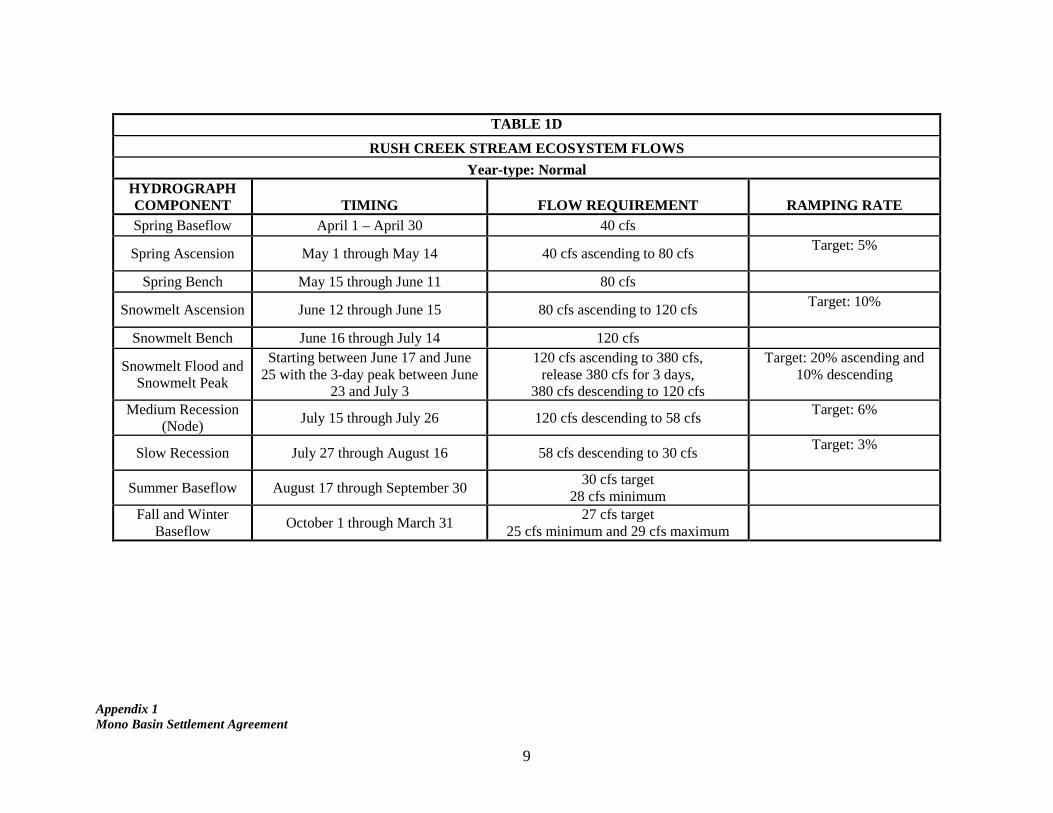
TABLE 1D
RUSH CREEK STREAM ECOSYSTEM FLOWS
Year-type: Normal HYDROGRAPH COMPONENT TIMING FLOW REQUIREMENT RAMPING RATE Spring Baseflow April 1 – April 30 40 cfs
Spring Ascension May 1 through May 14 40 cfs ascending to 80 cfs Target: 5%
Spring Bench May 15 through June 11 80 cfs
Snowmelt Ascension June 12 through June 15 80 cfs ascending to 120 cfs Target: 10%
Snowmelt Bench June 16 through July 14 120 cfs
Snowmelt Flood and Snowmelt Peak
Starting between June 17 and June 25 with the 3-day peak between June
23 and July 3
120 cfs ascending to 380 cfs, release 380 cfs for 3 days,
380 cfs descending to 120 cfs
Target: 20% ascending and 10% descending
Medium Recession
(Node) July 15 through July 26 120 cfs descending to 58 cfs
Target: 6%
Slow Recession July 27 through August 16 58 cfs descending to 30 cfs Target: 3%
Summer Baseflow August 17 through September 30 30 cfs target
28 cfs minimum
Fall and Winter Baseflow
October 1 through March 31 27 cfs target
25 cfs minimum and 29 cfs maximum
Appendix 1 Mono Basin Settlement Agreement
10
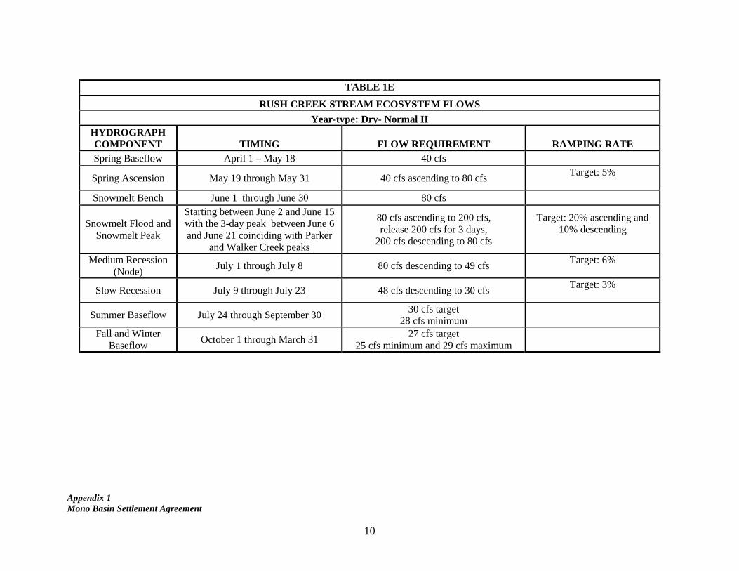
TABLE 1E
RUSH CREEK STREAM ECOSYSTEM FLOWS
Year-type: Dry- Normal II HYDROGRAPH COMPONENT TIMING FLOW REQUIREMENT RAMPING RATE Spring Baseflow April 1 – May 18 40 cfs
Spring Ascension May 19 through May 31 40 cfs ascending to 80 cfs Target: 5%
Snowmelt Bench June 1 through June 30 80 cfs
Snowmelt Flood and Snowmelt Peak
Starting between June 2 and June 15 with the 3-day peak between June 6 and June 21 coinciding with Parker
and Walker Creek peaks
80 cfs ascending to 200 cfs, release 200 cfs for 3 days,
200 cfs descending to 80 cfs
Target: 20% ascending and 10% descending
Medium Recession (Node)
July 1 through July 8 80 cfs descending to 49 cfs Target: 6%
Slow Recession July 9 through July 23 48 cfs descending to 30 cfs Target: 3%
Summer Baseflow July 24 through September 30 30 cfs target
28 cfs minimum
Fall and Winter Baseflow
October 1 through March 31 27 cfs target
25 cfs minimum and 29 cfs maximum
Appendix 1 Mono Basin Settlement Agreement
11
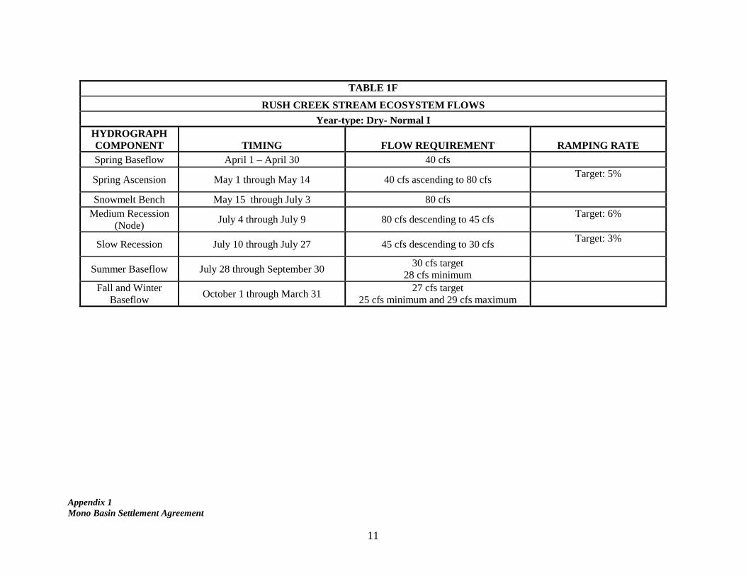
TABLE 1F
RUSH CREEK STREAM ECOSYSTEM FLOWS
Year-type: Dry- Normal I HYDROGRAPH COMPONENT TIMING FLOW REQUIREMENT RAMPING RATE Spring Baseflow April 1 – April 30 40 cfs
Spring Ascension May 1 through May 14 40 cfs ascending to 80 cfs Target: 5%
Snowmelt Bench May 15 through July 3 80 cfs
Medium Recession (Node)
July 4 through July 9 80 cfs descending to 45 cfs Target: 6%
Slow Recession July 10 through July 27 45 cfs descending to 30 cfs Target: 3%
Summer Baseflow July 28 through September 30 30 cfs target
28 cfs minimum
Fall and Winter Baseflow
October 1 through March 31 27 cfs target
25 cfs minimum and 29 cfs maximum

Appendix 1 Mono Basin Settlement Agreement
12
TABLE 1G
RUSH CREEK STREAM ECOSYSTEM FLOWS
Year-type: Dry HYDROGRAPH COMPONENT TIMING FLOW REQUIREMENT RAMPING RATE Spring Baseflow April 1 – April 30 30 cfs
Spring Ascension May 1 through May 17 30 cfs ascending to 70 cfs Target: 5%
Snowmelt Bench May 18 through July 6 70 cfs
Medium Recession (Node)
July 7 through July 12 70 cfs descending to 45 cfs Target: 6%
Slow Recession July 13 through July 27 45 cfs descending to 30 cfs Target: 3%
Summer Baseflow July 28 through September 30 30 cfs target
28 cfs minimum
Fall and Winter Baseflow
October 1 through March 31 27 cfs target
25 cfs minimum and 29 cfs maximum
Appendix 1 Mono Basin Settlement Agreement
13
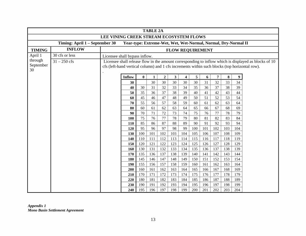
TABLE 2A
LEE VINING CREEK STREAM ECOSYSTEM FLOWS
Timing: April 1 – September 30 Year-type: Extreme-Wet, Wet, Wet-Normal, Normal, Dry-Normal II
TIMING INFLOW FLOW REQUIREMENT April 1 through September 30
30 cfs or less Licensee shall bypass inflow. 31 – 250 cfs Licensee shall release flow in the amount corresponding to inflow which is displayed as blocks of 10
cfs (left-hand vertical column) and 1 cfs increments within such blocks (top horizontal row). .
Inflow 0 1 2 3 4 5 6 7 8 9
30
30 30 30 30 30 31 32 33 34 40 30 31 32 33 34 35 36 37 38 39 50 35 36 37 38 39 40 41 42 43 44 60 45 46 47 48 49 50 51 52 53 54 70 55 56 57 58 59 60 61 62 63 64 80 60 61 62 63 64 65 66 67 68 69 90 70 71 72 73 74 75 76 77 78 79
100 75 76 77 78 79 80 81 82 83 84 110 85 86 87 88 89 90 91 92 93 94 120 95 96 97 98 99 100 101 102 103 104 130 100 101 102 103 104 105 106 107 108 109 140 110 111 112 113 114 115 116 117 118 119 150 120 121 122 123 124 125 126 127 128 129 160 130 131 132 133 134 135 136 137 138 139 170 135 136 137 138 139 140 141 142 143 144 180 145 146 147 148 149 150 151 152 153 154 190 155 156 157 158 159 160 161 162 163 164 200 160 161 162 163 164 165 166 167 168 169 210 170 171 172 173 174 175 176 177 178 179 220 180 181 182 183 184 185 186 187 188 189 230 190 191 192 193 194 195 196 197 198 199 240 195 196 197 198 199 200 201 202 203 204
Appendix 1 Mono Basin Settlement Agreement
14
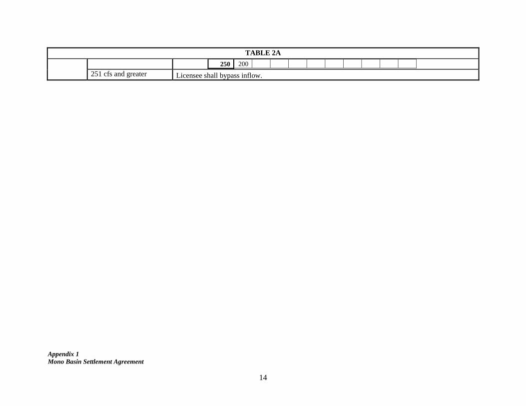
TABLE 2A
250 200
251 cfs and greater Licensee shall bypass inflow.

Appendix 1 Mono Basin Settlement Agreement
15
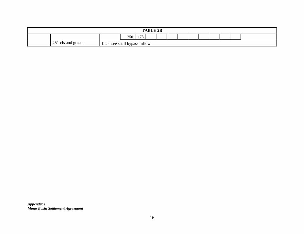
TABLE 2B
LEE VINING CREEK STREAM ECOSYSTEM FLOWS
Timing: April 1 – September 30 Year-type: Dry-Normal I, Dry
TIMING INFLOW FLOW REQUIREMENT April 1 through September 30
30 cfs or less Licensee shall bypass inflow. 31 – 250 cfs Licensee shall release flow in the amount corresponding to inflow which is displayed as blocks of 10
cfs (left-hand vertical column) and 1 cfs increments within such blocks (top horizontal row).
Inflow 0 1 2 3 4 5 6 7 8 9
30
30 30 30 30 30 30 30 30 30 40 30 30 30 30 30 30 30 30 30 30 50 30 30 30 30 30 30 30 30 31 32 60 32 33 34 34 35 36 36 37 38 38 70 39 40 41 41 42 43 43 44 45 45 80 46 47 47 48 49 49 50 51 52 52 90 53 54 54 55 56 56 57 58 59 59
100 60 61 61 62 63 64 64 65 66 66 110 67 68 69 69 70 71 72 72 73 74 120 74 75 76 77 77 78 79 80 80 81 130 82 82 83 84 85 85 86 87 88 88 140 89 90 91 91 92 93 94 94 95 96 150 97 97 98 99 100 100 101 102 103 103 160 104 105 106 106 107 108 109 109 110 111 170 112 112 113 114 115 115 116 117 118 118 180 119 120 121 121 122 123 124 124 125 126 190 127 128 128 129 130 131 131 132 133 134 200 134 135 136 137 138 138 139 140 141 141 210 142 143 144 144 145 146 147 148 148 149 220 150 151 151 152 153 154 155 155 156 157 230 158 158 159 160 161 162 162 163 164 165 240 165 166 167 168 169 169 170 171 172 172
Appendix 1 Mono Basin Settlement Agreement
16
TABLE 2B
250 173
251 cfs and greater Licensee shall bypass inflow.
Appendix 1 Mono Basin Settlement Agreement
17
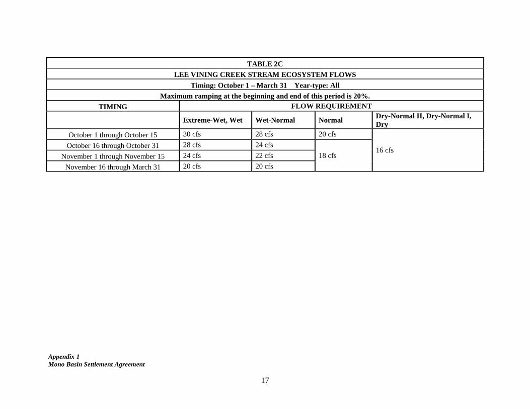
TABLE 2C
LEE VINING CREEK STREAM ECOSYSTEM FLOWS
Timing: October 1 – March 31 Year-type: All
Maximum ramping at the beginning and end of this period is 20%.
TIMING FLOW REQUIREMENT
Extreme-Wet, Wet Wet-Normal Normal
Dry-Normal II, Dry-Normal I, Dry
October 1 through October 15 30 cfs 28 cfs 20 cfs
16 cfs October 16 through October 31 28 cfs 24 cfs
18 cfs November 1 through November 15 24 cfs 22 cfs
November 16 through March 31 20 cfs 20 cfs
Appendix 1 Mono Basin Settlement Agreement
18
Condition 2 replaces the provision in Order 98-05 ¶ 1.b(2)(b)(2) requiring study of modifying Grant Dam. 2. Grant Outlet
LADWP shall modify the Grant Lake Reservoir Facilities to include an outlet which assures reliable delivery of the flow requirements specified in Table 1 (Grant Outlet). a. Further Approvals of Design. Licensee shall undertake further due diligence to
choose among designs capable of reliably releasing the flows specified in Table 1. Within 18 months, Licensee shall petition the Division of Water Rights to approve a design, including engineering specifications, for the Grant Outlet. That petition shall include any environmental analysis of that design required under the California Environmental Quality Act. By that date, it shall also apply for any other regulatory approvals necessary for construction, operation, and maintenance of this facility, including any necessary environmental analysis. Licensee shall request and take all reasonable steps to obtain such further approvals so as to permit Licensee to complete construction, and begin operation, within four years of the [order approving this Settlement].
b. Construction and Operation. Licensee shall begin construction of the Grant Outlet within 12 months of receiving necessary regulatory approvals. Licensee shall complete construction and begin to operate Grant Outlet within 18 months of receiving such final regulatory approvals. .
c. Progress Reports. Licensee shall submit quarterly progress reports to the Division
of Water Rights during the design, permitting, and construction of Grant Outlet. If it cannot achieve a deadline for reasons beyond its control, Licensee shall timely request an extension of time from the Division of Water Rights, and other Parties may reply.
d. Funding. In order to offset the capital cost of Grant Outlet, Licensee may divert up to 12,000 acre-feet of water from the Mono Basin additional to the amount otherwise permitted by D-1631 ¶ 6.a for the period when Mono Lake is at or above 6,380 feet and below 6,391 feet MSL (“Additional Export”).
(1). Compliance. Licensee shall not divert Additional Export in a manner that
causes a variance from the flow and minimum storage requirements specified in Condition 1.
(2). Schedule. The additional export will become available on the following schedule:
i. 4,000 acre-feet upon receipt of final permits to construct the Grant Outlet;
Appendix 1 Mono Basin Settlement Agreement
19
ii. 4,000 acre-feet upon active construction of the Grant Outlet;
iii. 2,000 acre-feet subsequent to the first wet year in which the outlet
is operated to release the flows specified in Table 1; and
iv. 2,000 acre-feet subsequent to the second wet year in which the outlet is operated to release the flows specified in Table 1.
(3). Adjustment. The schedule and amount of Additional Export are subject to adjustment in four circumstances:
i. By further agreement between the Parties and the further approval of the Division of Water Rights.
ii. If non-licensee funds are timely secured to pay for all or part of the capital cost of the Grant Outlet. In that event, the Additional Export shall be reduced by an acre-foot amount equivalent to value of the funding using the current Metropolitan Water District Full Service Untreated Volumetric Cost Tier II rate.
iii. If the total value of the Additional Export, as measured by the current Metropolitan Water District Full Service Untreated Volumetric Cost Tier II rate, exceeds 50% of the capital cost of the Grant Outlet. In that event, the Additional Export shall be reduced to ensure that the value of the Additional Export does not exceed 50% of the capital cost.
iv. If, for any reason, Grant Outlet does not begin operation within four years of the date of this [order]. In that event, Licensee shall not be allowed any Additional Export and shall compensate for any Additional Export that has already occurred, by reducing further allowable export by an equivalent amount.
(4). Planning. Licensee shall develop the schedule and other specifications for
Additional Export in the Mono Basin Operation Plan and Annual Operations Plan.
Condition 3 replaces the requirement in Order 98-05 ¶ 2(a)-(b) for a Grant Lake Operations and Management Plan. 3. Mono Basin Operations Plan
Licensee shall develop, implement, and periodically revised a Mono Basin Operations Plan (MBOP). The MBOP shall specify the rules, guidelines, and criteria for operation
Appendix 1 Mono Basin Settlement Agreement
20
of Licensee’s Mono Basin facilities to meet all applicable requirements across all year-types.
a. Content. Licensee shall base the MBOP on the Licensee’s Grant Lake
Operations and Management Plan (Feb. 29, 1996) as approved in Order 98-05 ¶ 2, taking into account the flow requirements in Condition 1, the capabilities of the Grant Outlet, and other subsequent requirements and information. MBOP shall: (1) be consistent with the outline attached as Attachment [number], (2) provide for development of Annual Operations Plans (AOP); and (3) supplement the rules and criteria for storage in Grant Lake Reservoir as specified in Condition 1.b(2) as necessary to assure reliable operation of the Grant Outlet to deliver the flow requirements in Table 1.
b. Initial Planning Process. Within one year, Licensee shall develop the MBOP and submit it to the Division of Water Rights, for approval.
(1). Licensee shall consult with Stream Monitoring Team and Parties in the
development of the initial MBOP and any revision thereto. It shall provide a draft plan for their review and comment. Licensee shall convene a meeting to address such comments. A representative of the Division of Water Rights may attend.
(2). Licensee shall use eSTREAM (Ex. [number]) or an equivalent daily
planning tool for this purpose. Licensee shall grant Parties permission to use the model, including any update, to assist with the development of the plan or revision.
(3). The Division of Water Rights shall review and approve the plan, subject to appropriate modifications.
c. Revisions. Following such initial approval, Licensee shall develop and submit appropriate revisions to the MBOP when construction of Grant Outlet is complete, and every five years following such completion of construction, or more frequently if recommended by the Stream Monitoring Team, to take into account operating experience for Grant Outlet. For such revisions, the Licensee shall follow the procedures specified in Condition 3.b.
Condition 4 revises Order 98-05 ¶ 3. 4. Annual Operations Plan
Licensee shall develop and implement Annual Operations Plans consistent with MBOP.
a. Content. AOP shall specify Licensee’s plans to operate its Mono Basin facilities
for the runoff year to reliably release flow requirements and meet all other
Appendix 1 Mono Basin Settlement Agreement
21
applicable requirements, taking into account the year-type and other specific circumstances.
(1). It shall be consistent with the MBOP.
(2). It shall incorporate any adaptive management of flow requirements
recommended by the Stream Monitoring Team, as provided in Condition 5.b.
(3). It shall provide for electronic reporting to the Stream Monitoring Team and Parties describing the implementation of specified plan of operation, including actual runoff, exports, and bypass flows.
b. Development. By May 15 of each year, Licensee shall develop and submit an
AOP to the Division of Water Rights for review and approval. (1). By March 31 of each year, the Licensee shall convene a meeting to
prepare for developing the AOP, and specifically to address any adaptive management of SEFs, monitoring results, and forecasts of hydrology and exports. The meeting shall include: Stream Monitoring Team, Parties, and others as appropriate.
(2). By April 15, Licensee shall distribute a draft AOP to the Stream Monitoring Team and Parties for review and comment. Not later than May 5 Licensee shall convene an in-person a meeting to discuss and resolve such comments. A representative of the Division of Water Rights may attend.
(3). By May 15, Licensee shall submit the final AOP. The Division of Water Rights shall review and approve the AOP, subject to appropriate modifications.
c. Reporting. Following approval, Licensee shall report implementation of the AOP. (1). Licensee shall submit a monthly report to the Stream Monitoring Directors
and the other Parties, not later than ten calendar days after the end of the month. Each report shall include actual runoff and operations data by comparison to the AOP forecasts, and actual and projected adjustments in operations necessary to respond to changed or unanticipated conditions.
(2). Licensee shall meet and confer with the Stream Monitoring Team and other Parties to address projections of significant adjustments in operations.
Appendix 1 Mono Basin Settlement Agreement
22
(3). Licensee shall submit a quarterly report to the Division of Water Rights. This report shall describe actions taken by the Licensee that relate to implementation of the AOP.
Condition 5 revises Order 98-05 ¶ 1.b, as amended by Order 98-07, as follows. Condition 5.a(1) replaces the requirements in pp. 93 - 110 in the Licensee’s Stream and Stream Channel Restoration Plan (January 1997) as approved in Orders 98-05 and 98-07. Condition 5.a(2) replaces the termination criteria in Order 98-07 ¶ 1.b(5). Condition 5.b-c revises (supplements) the requirements in Order 98-05 ¶ 1.b(2)(c) for Annual Monitoring Reports. Condition 5.d replaces Order 98-05 ¶ 1.b(2)(a). Condition 5.e revises Order 98-05 ¶ 1.e. 5. Stream Monitoring and Restoration Program
a. Stream Monitoring. The Stream Monitoring Team shall monitor pursuant to the
following requirements, (1). The team shall conduct those tasks specified in Appendix 2, which
implements Chapter 7 of the Synthesis Report. The team may adjust the priorities and other details for such tasks, on the basis of recommendation as provided in Condition 5.c.
(2). The Stream Monitoring Team shall apply the metrics stated in Appendix 3. The results of monitoring shall be used to:
i. inform adaptive management of the SEFs, restoration program, and operations of Licensee’s Mono Basin facilities;
ii. inform the Board and the public of the status of stream and fishery restoration in light of the factors stated in Order 98-05 ¶ 1.b(4); and
iii. serve as the basis for any further revisions to or termination of the monitoring program.
b. Adaptive Management. The flow requirements in Condition 1 are subject to
adaptive (including real-time) management to achieve the goals specified in Order 98-05 ¶ 1.b(4).
(1). Form. The Stream Monitoring Team may recommend adaptive
management of flow requirements in one of two ways:
i. In the Annual Monitoring Report and in comments to the AOP, for implementation in the following year.
Appendix 1 Mono Basin Settlement Agreement
23
ii. On a real-time basis in response to unforeseen circumstances, especially during wetter than average years. Such recommendations shall be made by written notice to the Division of Water Rights. Such recommendations shall be developed in consultation with Licensee and Parties, each of whom shall designate representatives with the qualifications and authority necessary to assist in such adaptive management.
(2). Implementation. The Licensee shall implement such recommendation unless timely disputed pursuant to the procedure specified in Order 98-05 ¶ 5 and Condition 9.
(3). Range. Such adaptive management may modify the flow requirements specified in Table 1 or 2, by:
i. Modifying the start or end dates, duration, or ramping rate of a
hydrograph component, or specifying the timing or magnitude of a flow release in excess of Table 1 or 2 due to other license requirements, in order to improve ecological functions; or
ii. Temporarily reducing flow for safety during stream monitoring activities.
(4). Limitations. Such adaptive management, including the range specified in
paragraph (3), shall not materially: (i) increase the volume of water required to meet the flow requirements in the applicable table and the requirements of Decision 1631 ¶ 6, (ii) reduce allowable export, or (iii) increase Licensee’s operational or capital costs. Further, such adaptive management does not authorize Licensee to take any action otherwise prohibited by its Licenses.
c. Annual Monitoring Reports. By [date], the Stream Monitoring Team shall submit
to the Licensee the Annual Monitoring Report specified by Order 98-07 ¶¶ 1.b(2)(c). (1). The team shall consult with Licensee and the other Parties in the
preparation of these reports. It shall provide draft reports for their review and comment.
(2). Licensee shall submit these annual reports to the Division of Water Rights. Its submittal may include comments on the final report’s findings and recommendations.
d. Periodic Overview Report. The Stream Monitoring Team shall develop a
Periodic Overview Report on the Stream Monitoring and Restoration Program.
Appendix 1 Mono Basin Settlement Agreement
24
This shall occur after Licensee has operated Grant Outlet to release SEFs in two above-Normal runoff years, at least one of which is Wet or Extreme Wet. (1). The report shall evaluate trends in stream conditions relative to the metrics
stated in Condition 5.a(2) and Order 98-05 ¶ 1.b(4). It shall make recommendations for changes to the stream monitoring and restoration program to increase effectiveness or reduce cost of the program, or for termination thereof.
(2). In the development of the Periodic Overview Report, the Stream Monitoring Team shall consult with Licensee and Parties and shall provide a draft plan for their review and comment.
(3). The Stream Monitoring Team shall submit the Periodic Overview Report to the Division of Water Rights. In response to this report, Licensee may move for changes in the program or termination thereof. After considering any motion, responses thereto, or other comments by the Licensee or other Parties, the Division shall review and take final action on the recommendations in the report.
e. Channel Maintenance. Stream Monitoring Team shall reopen and maintain side-
channel entrances as recommended on pp. 129 – 131 of the Synthesis Report. The team or subconsultant shall be responsible to comply with any permitting requirements, and Licensee shall support such permitting and provide land access as necessary.
Condition 6 revises Order 98-05 ¶¶ 4 and 6, as follows. Condition 6.a revises Order 98-05 ¶ 6.d.1. Condition 6.b revises the requirement in Order 98-05 ¶ 6.d(3) that Licensee file an annual report by April 1. It adds the requirement that the Limnology and Waterfowl Directors prepare scientific reports, conforming to the existing requirement for the Stream Monitoring Program. Condition 6.c revises (supplements) the requirements in Order 98-05 ¶ 6.d(3). Condition 6.d revises Order 98-05 ¶ 4.b. 6. Waterfowl Habitat Restoration Program.
a. Directors.
(1). Dr. John Melack (University of California Santa Barbara) shall direct and
conduct the limnology monitoring described in Licensee’s Waterfowl Habitat Restoration Plan (February 1996) as approved in Order 98-05 ¶4.d. The Division of Water Rights shall designate any successor, who shall have expertise in the limnology of saline lakes, after considering the recommendations of the Parties.
Appendix 1 Mono Basin Settlement Agreement
25
(2). By [date], the Licensee and the Parties shall jointly nominate a director of the waterfowl population monitoring described in Waterfowl Habitat Restoration Plan. In the event of a dispute, the Division of Water Rights shall designate the director pursuant to the procedure provided in Order 98-05 ¶ 5.
b. Monitoring Program. The Limnology and Waterfowl Directors shall continue the
previously authorized monitoring programs, as may be modified by the Division of Water Rights on the basis of the Periodic Overview Report, in response to a motion by Licensee or another Party, or as otherwise determined.
c. Annual Monitoring Report. By [date] each year, the Limnology and Waterfowl Directors shall each submit an Annual Monitoring Report to the Licensee, including evaluation of results and any recommendations for changes in the Waterfowl Habitat Restoration Program. (1). In the development of their respective annual reports, the Limnology and
Waterfowl Directors shall consult with the Licensee and other Parties and shall provide drafts for their review and comment.
(2). Licensee shall submit the final Annual Monitoring Reports to the Division
of Water Rights. Its submittal may include comments on the findings and recommendations stated in the reports. After considering any comments by Licensee or other Parties, the Division shall review and take final action on any recommendations stated in the reports.
d. Periodic Overview Report. Every five years, the Waterfowl and Limnology
Directors shall jointly develop a Periodic Overview Report on the Waterfowl Program. The report shall evaluate trends and make recommendations for changes to the Waterfowl Program to increase effectiveness or reduce cost. (1). In the development of the Periodic Overview Review, the Waterfowl and
Limnology Monitoring Directors shall consult with Licensee and Parties and shall provide a draft report for their review and comment.
(2). The Waterfowl and Limnology Directors shall submit their Periodic Overview Report to the Division of Water Rights. In response to this report, Licensee may move for changes in the program or termination thereof. After considering any motion, responses thereto, or other comments by Licensee or other Parties, the Division shall review and take final action on any recommendations stated in the report.
e. Habitat Improvements. The Waterfowl Monitoring Director may recommend use
of the funds authorized by Order 98-05 ¶ 4.b, for the purpose of improving waterfowl habitat on U.S. Forest Service lands or elsewhere in the Mono Basin.
Appendix 1 Mono Basin Settlement Agreement
26
This director or subconsultants shall be responsible to comply with any permitting requirements, and Licensee shall support such permitting and provide land access as necessary.
Condition 7 revises Order 98-05 1.b.(1) and 4.d, by establishing a new agency for the purpose of contracting with the Monitoring Directors. 7. Mono Basin Monitoring Administration Team.
a. Purposes. The Mono Basin Monitoring Administration Team (MAT) shall be
established to: (1) develop an annual Expenditure Plan for monitoring and specified restoration actions; and (2) oversee a Fiscal Administrator’s contracts with the Stream Monitoring Team, Limnology, and Waterfowl Directors (collectively, Monitoring Directors), for the performance of their respective monitoring tasks, and any contract for administrative services necessary for the MAT carry out its purposes.
b. Governance. The MAT shall consist of: California Department of Fish and Wildlife, Mono Lake Committee, California Trout (with respect to the stream monitoring and restoration program only), and the Licensee.
(1). Within 6 months after [the order approving Appendix 1], the MAT
members shall enter into an agreement specifying meeting and governance procedures, including procedures that provide for timely resolution of any disputes.
i. Under these procedures, the MAT shall carry out all actions approved by a majority of its members unless and until directed otherwise by the Division of Water Rights pursuant to Order 98-05 ¶ 5 and Condition 9. A MAT member may not delay or prevent action by inaction or failure to participate in votes.
ii. These procedures shall permit an independent annual audit under standard procedures used for a non-profit corporation. The cost of an audit shall be covered from a mutually agreeable source other than the funding provided by Licensee under Section 7.f.
(2). Each member shall designate a representative who shall participate in the
MAT’s deliberations and votes, as follows: (i) for Licensee, the Aqueduct Manager or higher; (ii) for DFW, an Environmental Scientist or higher; (iii) for Mono Lake Committee, the Eastern Sierra Policy Director or higher; and (iv) for California Trout, the Eastern Sierra Program Manager or higher.
Appendix 1 Mono Basin Settlement Agreement
27
(3). The MAT shall conduct the tasks below in a manner that assures that funds are managed and used as authorized here and by further order of the Division of Water Rights.
c. Fiscal Administrator. The MAT shall select and supervise a Fiscal Administrator,
who shall be responsible: to (1) enter into and administer contracts with Monitoring Directors, (2) pay their invoices, and (3) perform certain other administrative duties.
d. Administration of Monitoring Account.
(1). Account. The Fiscal Administrator shall establish and administer a Mono
Basin Monitoring Account at a bank or similar financial institution.
(2). Contracting with Monitoring Directors.
i. The Fiscal Administrator shall prepare contracts and annual task orders with the Monitoring Directors, for the MAT’s review and approval. Upon such approval, the Fiscal Administrator shall execute a contract or work order, as applicable.
ii. At the request of the applicable Monitoring Director, the Fiscal Administrator may enter into a conforming contract with a subconsultant for the performance of a monitoring task or a restoration project.
iii. The Monitoring Directors may assign tasks to Licensee’s
employees for performance, subject to the Licensee’s approval and provided Licensee is responsible for the costs associated with such performance.
(3). Invoices. The MAT shall review invoices for consistency with the
approved Expenditure Report and Plan and applicable work orders. Upon its approval of an invoice, MAT shall instruct Fiscal Administrator to pay the invoice.
e. Other Administration. The Fiscal Administrator, directly or through a contractor acceptable to the MAT, shall: (1) assist the Licensee, MAT, and Monitoring Directors in convening meetings related to the preparation of required plans and report, (2) report to the MAT on all contracts and expenditures, and (3) assist MAT in preparation of the Expenditure Report and Plan and related matters.
f. Funding. Licensee shall fund the Mono Basin Monitoring Account, as follows.
Appendix 1 Mono Basin Settlement Agreement
28
(1). Within 30 days of [order approving settlement], Licensee shall make one-time payments of: (i) $500,000 for stream restoration projects as specified in Condition 5.e; and (ii) $275,000, pursuant to Order 98-05 ¶ 4.b as amended by Condition 6.e.
(2). By November 1 of each year, Licensee shall make an annual payment to the Monitoring Account for the purpose of next year’s monitoring and associated administrative costs. This payment shall be $575,000 (2013), of which $299,000 shall be for stream monitoring, and $276,000 for waterfowl and limnology monitoring. This payment shall be adjusted annually by CPI (Los Angeles-Riverside).
(3). Not later than September 1, the Licensee shall notify the Division of Water Rights if it disputes its obligation to provide such funding as required by Condition 7.f(2). Any such dispute shall be limited to the issue whether the MAT has performed as required by this condition. The Division shall undertake to resolve such dispute not later than November 1. Licensee shall not withhold any required payment to the Mono Basin Monitoring Account unless and until the Division authorizes such action following resolution of Licensee’s dispute.
(4). The Division of Water Rights shall amend or end this funding obligation upon its termination of some or all of the monitoring programs, respectively. Under authority of Decision 1631 and Orders 98-05 and 98-07, the Division shall not increase the amount of funding required to be provided by Licensee.
g. Expenditure Report and Plan. By [date], the MAT shall submit an Expenditure Report and Plan to the Division of Water Rights. The MAT, in consultation with the Monitoring Directors and the Fiscal Administrator, shall prepare a draft 30 days before [date]. (1). The report shall include an accounting of all expenditures, contracts, and
related matters in that year.
(2). The plan shall propose a plan for expenditure of the annual funding for the following year’s monitoring tasks. It may propose: priorities for monitoring within the scope of the approved monitoring programs, the carry-over of funds to subsequent years for non-annual monitoring tasks, and the use of funds to cover the necessary costs of administration, including the Fiscal Administrator.
(3). The Division of Water Rights shall review and approve the expenditure plan, subject to any appropriate modifications.
Appendix 1 Mono Basin Settlement Agreement
29
h. Termination of MAT. At any time after 10 years from [date of this order], Licensee may request termination of MAT, and Division of Water Rights shall approve such termination upon approval of an alternative method to implement required monitoring programs. At any time, the Division may terminate the MAT on its own initiative, or on motion demonstrating that the MAT has not performed as required in this Condition 7, or that the MAT’s continuing administration of the monitoring programs will not be cost-effective. Termination of the MAT shall not terminate Licensee’s obligations under this [order]. Any funds remaining in the Mono Basin Monitoring Account upon termination of the MAT shall revert to Licensee.
i. Limitations. The Licensee shall operate its Mono Basin facilities in compliance
with all applicable requirements. It shall not delegate any such responsibility to the MAT.
Condition 8 amends Decision 1631 ¶ 6.a(4). 8. Lake Hearing
In the event that the water level of Mono Lake has not reached an elevation of 6,391 feet by September 28, 2020, the Board will hold a hearing to consider the condition of the lake and the surrounding area, and will determine if any further revisions to this license are appropriate.
Condition 9 amends Order 98-05 ¶ 5. 9. Dispute Resolution and Hearing Procedures.
a. Parties. For the purpose of Order 98-05 ¶ 5, Parties means: California
Department of Fish and Wildlife, Mono Lake Committee, California Trout, [and].
b. Service. Any notice or other document submitted to the Division of Water Rights pursuant to these conditions shall be simultaneously served to the Parties by electronic mail or equivalent method.
c. Informal Dispute Resolution. The Division of Water Rights shall encourage and assist the Parties to undertake informal dispute resolution.
Mono Basin Stream Scientists Synthesis Report Chapter 7 Monitoring Plan
Appendix 2 Mono Basin Settlement Agreement
1
Technical Memorandum
Scope of Future Work
For the Mono Basin Stream and Fisheries Monitoring Program
to Accomplish Goals of Chapter 7 of the Synthesis Report
Ross Taylor and Bill Trush From April 26, 2013 Technical Memorandum
Ross Taylor met with LADWP, California Department of Fish and Wildlife, the Mono Lake Committee,
and California Trout (the ‘Parties’ group) on February 12, 2013 to discuss Chapter 7 (topic: future
monitoring) of the Stream Scientists’ 2010 Synthesis Report. Chapter 7 outlines development of a
stream and fisheries monitoring program and an adaptive management plan once the SEFs have been
finalized operationally. Chapter 7 has been the focus of settlement discussions between the Parties
regarding future monitoring goals and responsibilities, given the absence of the Stream Scientists from
the Parties process. At this meeting, the Parties concluded that the Stream Scientists needed to
recommend a monitoring package using Chapter 7 as a framework, and should consider how their
recommended tasks would be incorporated into an adaptive management program, as well as budget
each monitoring task. The Stream Scientists’ recommendations would be considered part of a larger,
overall monitoring plan that also recommends waterfowl surveys and Mono Lake limnology monitoring.
The February 12th meeting concluded with the Stream Scientists (Ross Taylor and Bill Trush) tasked with
developing a recommended monitoring package based on tasks listed in Chapter 7. This package was to
include information on how recommended tasks would be incorporated into an adaptive management
program.
Ross Taylor and Bill Trush met jointly with the Parties on March 18, 2013 and presented a draft
Technical Memorandum detailing a package of monitoring tasks. Discussion and review at the meeting
and subsequent work by the Stream Scientists resulted in revisions to the package culminating in a
finalized Technical Memorandum dated April 26, 2013. The Stream Scientists believe that the
monitoring tasks in that Memorandum are suitable to accomplish the goals of Chapter 7 of the Synthesis
Report, and they are listed here.
Future monitoring fell into the three categories:
Compliance Monitoring to assure the State Water Resources Control Board (SWRCB) that LADWP is
releasing the Rush, Parker, Walker, and Lee Vining Creek SEFs as specified in a new Order. LADWP staff
Mono Basin Stream Scientists Synthesis Report Chapter 7 Monitoring Plan
Appendix 2 Mono Basin Settlement Agreement
2
would be responsible for funding and executing the compliance monitoring, including Grant Lake
Reservoir limnology.
Performance Monitoring informs all parties that the SEFs are achieving what they were expected to
accomplish (i.e., performance) relative to the Desired Ecological Outcomes in Table 3.1 of the Synthesis
Report. Performance monitoring could be used adaptively to fine‐tune the SEFs.
Research Investigations Requiring Monitoring to improve/challenge our quantitative insight into key
ecological processes—upon which the Synthesis Report was based—that could lead to innovative
recovery actions.
Performance Monitoring
The stream and fisheries monitoring presented in Chapter 7 of the Synthesis Report outlined tasks that
would guide an adaptive management program and focused on: (1) validating the SEF regimes were
providing the intended ecological benefits and (2) assisting in fine‐tuning the flow regimes within the
recommended SEF hydrographs.
The Stream Scientists envision that recommended performance monitoring tasks would commence in
the summer–fall of 2014 and would occur either annually or would be water‐year triggered. Each year’s
monitoring efforts would be presented in report‐format to the SWRCB. For example, an annual fisheries
report would be drafted, similar to the annual compliance report developed by the Fisheries Stream
Scientist. The Stream Scientists suggest meeting in‐person for at least one of the two recommended
semi‐annual meetings. At year‐8, it is recommended that an instream flow study be considered (in part
depending on how well channel complexity has advanced) to re‐evaluate expected changes in
streamflow‐habitat relationships in Rush and Lee Vining creeks. After year‐10, the final reports would be
summarized into a final review of the SEFs and recommendations regarding which performance
monitoring tasks should continue.
The following section briefly describes each monitoring task’s justification and concludes with a
summary table of the tasks.
Mono Basin Stream Scientists Synthesis Report Chapter 7 Monitoring Plan
Appendix 2 Mono Basin Settlement Agreement
3
Fisheries‐Based Performance Monitoring Tasks
Fisheries Monitoring Task #1: Annual Fisheries Sampling
Fisheries sampling should continue annually due to the short lifespan of brown and rainbow trout in
Rush and Lee Vining creeks, as well as the quick response in growth and condition factors as related to
water‐year type and flow regimes. Annual fisheries sampling should commence in September of 2014 to
maintain the continuous data set (started in 1999). Future monitoring should include mark‐recapture
estimates on Upper and Bottomlands reaches of Rush Creek and mainstem Lee Vining Creek. Depletion
estimates should be made on the Lee Vining Creek side‐channel and on Walker Creek. The MGORD
section of Rush Creek should be sampled for a mark‐recapture estimate in even years (two
electrofishing passes) and for RSD and condition factors in odd years (one electrofishing pass). Finally,
PIT tagging should be continued on an annual basis to track specific growth rates.
Fisheries Monitoring Task #1a: Single‐pass Fisheries Sampling in Odd Years
An alternative to conducting the fisheries sampling every year for the generation of population
estimates, is in odd‐years to conduct only single‐pass electrofishing in all sections of Rush, Lee Vining,
and Walker creeks (as we currently do in the MGORD section of Rush Creek). Single‐pass electrofishing
in all sections results in a significantly reduced budget in the post‐Synthesis Report monitoring period,
but will still provide valuable information on an annual basis. Single‐pass electrofishing in odd‐years
would still accomplish the following tasks:
1. Condition factor analysis based on weight and length data.
2. Length‐frequency histograms to evaluate age‐class structure.
3. RSD calculations to evaluate proportions of catchable‐sized trout.
4. Annual growth calculations based on recaptures of previously PIT tagged fish.
5. Implanting of PIT tags in new fish.
Task #1a: Odd‐year/Single‐pass Fisheries Sampling Assumptions This task’s work‐plan includes the following assumptions (1) Single‐pass sampling will be conducted by a
five‐person crew comprised of two consultants (Principal and Senior fisheries biologists) and three
employees (field technicians); (2) block fences will be used at the lower boundaries to prevent
downstream fish movement at end of sections; (3) PIT tagging will continue to be used to track specific
growth rates; (4) new PIT tags will be implanted during single‐pass sampling; (5) single‐pass effort would
only require five field sampling days and two travel days; and (6) reporting costs for odd‐year, single‐
pass sampling will also be reduced.
Fisheries Monitoring Task #2: Annual Fisheries Report
The annual report will present the data and provide an analysis and interpretation for each year’s fisheries monitoring. Additional sub‐tasks include entering and proofing data. These annual reports will
Mono Basin Stream Scientists Synthesis Report Chapter 7 Monitoring Plan
Appendix 2 Mono Basin Settlement Agreement
4
continue providing population estimates, age‐class structure analysis, density estimates, condition factors and RSD‐value calculations. The Task #2 work‐plan assumes that the report is distributed as a PDF.
Fisheries Monitoring Task #2a: Single‐pass Sampling Fisheries Report
The sub‐tasks to prepare the fisheries reports for single‐pass sampling events are similar to those described for Task #2. The numbers of hours for Task #2a report preparation are reduced because mark‐recapture and depletion estimates would not be generated. The Task #2a work plan also assumes that the report is distributed as a PDF.
Fisheries Monitoring Task #3: Pool and Habitat Typing Surveys One channel response to higher flow events is the production/maintenance of important habitats for
brown trout in Rush and Lee Vining creeks. The pool and habitat typing surveys should be conducted the
summer after above‐normal runoffs, or every five years. During the next 10 years of monitoring, no
more than three (3) pool surveys would be conducted. The work‐plan was based on the following
assumptions: (1) surveyed by the Principal and Senior fisheries biologists when they are already in the
Mono Basin for the annual fisheries sampling to minimize travel costs, (2) four (10‐hour) days to
complete Rush Creek and two (10‐hour) days to complete Lee Vining Creek, (3) surveys would cover the
same reaches completed in RY2011, and (4) for report development, the work‐plan assumes 20 hours
for the Principal fisheries biologist and 60 hours for the Senior fisheries biologist.
Fisheries Monitoring Task #4: Monitor Water Temperatures Future collection of water temperature data will be especially important on Rush Creek, both to track
conditions during construction phases on GLR Dam and to track changes in temperature due to GLR
management and climate change. Continuation of Lee Vining Creek temperature monitoring would be a
lower priority than Rush Creek because the past long‐term data have shown water temperatures in Lee
Vining Creek are not a concern regarding fish growth and condition factor. Work‐plan assumes
downloading of data loggers four times per year.

Mono Basin Stream Scientists Synthesis Report Chapter 7 Monitoring Plan
Appendix 2 Mono Basin Settlement Agreement
5
Geomorphic and Woody Riparian‐Based Performance Monitoring Tasks
Geomorphic Monitoring Task #1: Overall Main Channel Complexity in Rush Creek and Lee Vining Creek
Manning’s Coefficient (n) is an empirically derived, unit‐less measure of overall hydraulic roughness of
the stream channel. In the Plan for Monitoring the Recovery of Mono Basin Streams (Blue Book: Analysis
& Evaluation of Monitoring Data (January 12, 1997, p.8)), Manning’s n was considered an important
monitoring variable:
“Similarly, changes in channel roughness, principally from riparian colonization, will be plotted through
time (accomplished back‐calculating Manning’s n for specific flows on monitored cross‐sections). A
positive correlation of increasing roughness (now the dependent variable) with increasing floodplain
deposition for a given flow magnitude and duration is expected, quantitatively demonstrating an
important feedback loop for recovery.”
Annual Reports projected the significance of increasing roughness (measured as Manning’s n) on key
geomorphic recovery processes (also specified in the Desired Ecological Outcomes on the Synthesis
Report in Table 3‐1, p. 66). The desirability of re‐incorporating Manning’s n back into long‐term
monitoring resides in its universality (collectively sensitive to many forms of roughness), relative ease of
measurement given what it measures, and usefulness for predicting mainstem stage heights affected by
greater roughness (e.g., in the future, lower streamflows will be needed to enter side‐channels).
Eight channel reaches in Rush Creek and 3 channel reaches in Lee Vining Creek would be monitored for
trends in Manning’s n at bankfull discharge (approximately 350 cfs Rush Creek and 250 cfs Lee Vining
Creek) and greater. For the initial set‐up, each reach selected will need 1 to 3 cross‐sections surveyed
depending on local channel complexity, with passive peak stage recorders and stage plates installed.
Once a reach’s cross‐sections have been surveyed and monumented, an estimate for reach‐long slope
must be surveyed. Reach selection would be coupled with Geomorphic Monitoring Task #2 ‐‐‐ occupying
previous cross sections would be a priority. Fieldwork requirements for the set‐up in RY2014 would be
12 field days with Principal investigator and two field technicians. Following average to wetter years, six
field days with a Principal investigator and two field technicians are necessary for annual monitoring.
Geomorphic Monitoring Task #2: Floodplain Deposition in Lower Rush Creek and Lee Vining Creek
Three Desired Ecological Outcomes in Table 3‐1 of the Synthesis Report specify emergent, intermediate,
and advanced floodplain deposition as important recovery processes. Trend monitoring will require
relatively short segments of channel cross‐sections within the floodplain from Monitoring Task #1 that
will receive detailed surveying of their floodplain surfaces for documenting long‐term, net floodplain
aggradation. Floodplain depositional processes in Lower Rush Creek often included initial scour during a
Mono Basin Stream Scientists Synthesis Report Chapter 7 Monitoring Plan
Appendix 2 Mono Basin Settlement Agreement
6
peak event with subsequent deposition all within the same flood event resulting in no net deposition.
For long‐term monitoring, we would only measure net deposition.
Geomorphic Monitoring Task #3: Establish and operate a continuous stream gaging station in Lower Rush Creek Bill Trush has explored several feasible strategies for the installation and operation of an affordable flow gaging station on lower Rush Creek within the vicinity of the County Road crossing, as specified in the Synthesis Report. A flow gaging station at this location in lower Rush Creek is important because it would account for accretions from Parker and Walker Creeks as well as flow losses documented in past synoptic flow measurements.
Geomorphic Monitoring Task #4: Hydraulic Connectivity of Mainstem Channel to Floodplains Desired Ecological Outcomes (Table 3‐1, p.66 Synthesis Report): (1) Minimum streamflows recharging shallow groundwater and saturating emergent floodplain surfaces, (2) Off‐channel spring/early‐summer streamflow connectivity, and (3) Protect vigor of established riparian species along the mainstem and side‐channel margins as well as on the floodplain. This task is included in the Performance Monitoring, but bridges Compliance Monitoring, for keeping side‐channels hydraulically connected to the mainstem channel as discussed in the Synthesis Report (p. 129 sets no timetable for terminating side‐channel maintenance but does provide an inundation depth threshold) that requires groundwater/surface water monitoring and side‐channel surveying/maintenance.
The 4‐Floodplain and 8‐Floodplain complex in Lower Rush Creek will need to be surveyed in RY2014 to establish a physical monitoring infrastructure. This will include high‐end GPS monitoring for surveying riffle crest thalweg elevations in the mainstem, floodplains, and side‐channels. A series of well‐positioned benchmarks will make subsequent surveys easier to accomplish using more traditional surveying methods. Stage plates will be installed in the back of the 4‐Floodplain and in the 4‐Floodplain’s side‐channel; another gage plate will be installed in the first deep pool of the side‐channel in the 8‐Floodplain. This infrastructure of existing piezometers, a few a new additions, stage monitoring on floodplains and side‐channels, riffle crest and 2 existing piezometers on Lee Vining Creek also will be monitored but the infrastructure can be made using traditional surveying.
1ST Year Set‐Up in RY2014: Establish piezometer network, floodplain stage plates, side‐channel invert benchmarks, and riffle crest elevations from the top of elevations, and side‐channel entrance invert elevations will be monitored by an MLC intern in one day. Survey the B‐1 Connector of the 4‐Floodplain downstream to the bottom of the 4‐Floodplain using high‐grade GPS surveying methods (elevational error 1 to 2 cm). This task would require 5 field days for three field technicians plus office analyses and overlay of GPS data onto aerial photographs to make a master map from which to direct annual monitoring.
Mono Basin Stream Scientists Synthesis Report Chapter 7 Monitoring Plan
Appendix 2 Mono Basin Settlement Agreement
7
Geomorphic Monitoring Task #5: Photo Point Monitoring During the Synthesis Report preparation, ground‐based photos of distinct geomorphic features at several streamflows were almost as valuable as cross‐section data for documenting and interpreting geomorphic change. The utility of photo point monitoring relies on a disciplined routine. The Principal investigators will need to spend a total of 10 hours re‐occupying re‐established photo‐points at selected streamflows during the first year of fieldwork, then meet with MLC to schedule future photographic sessions. Photo management is critical. One technician will catalogue the photographs and provide a listing of new photographs in the annual report.
Woody Riparian Vegetation Monitoring Task #1: Measuring Cottonwood Vigor Table 3‐1 Desired Ecological Outcomes: Protect vigor of established riparian species along the mainstem
and side‐channel margins as well as on the floodplain.
1st Year Set‐Up: Select floodplain locations and trees for sampling. Measure 10 years of stem growth at 10 floodplain locations within Lower Rush Creek and four locations within Lee Vining Creek; averaging 50 cottonwood branches measured for annual growth per floodplain location. This 1ST Year set‐up will require 12 field days with a principal investigator and two field technicians.
Annual Monitoring of cottonwood vigor at 10 floodplain locations within Lower Rush Creek and four locations within Lee Vining Creek; 50 cottonwood branches measured for annual growth per floodplain location. Annual monitoring will require 6 field days with a principal investigator and two field technicians.
Woody Riparian Vegetation Monitoring Task #2: Woody Riparian Vegetation Acreage and Composition Woody Riparian Vegetation Recovery – measure woody riparian vegetation acreage and composition last done in 2009 by John Bair, adding another column to Table 7‐1, p. 130 of the Synthesis Report for RY2020.
Geomorphic/Woody Riparian Vegetation Monitoring Task #3 Prepare an Annual Report. Data presentation, analyses, reporting, and interpretation would culminate in an annual report. This task would require 40 hours of Principal investigator time and 2 technical assistants for 60 hours each for data management, directed analyses, and publishing.
Mono Basin Stream Scientists Synthesis Report Chapter 7 Monitoring Plan
Appendix 2 Mono Basin Settlement Agreement
8
Joint Fisheries and Geomorphic/Riparian‐Based Performance Monitoring Tasks
Joint Monitoring Task #1: Semi‐annual Meetings
Semi‐Annual Meetings will be required for scientists to keep the Parties and SWRCB informed. The
Stream Scientists recommend meeting twice yearly, similar to when the semi‐annual restoration
meetings used to occur. A meeting in the late‐fall (November) would allow reporting of all the year’s
activities prior to drafting an annual report. A spring meeting (April‐May) would focus on planning for
the upcoming season’s activities. Typically the type of water‐year has been forecasted by the time the
spring meeting is held, so flow‐triggered monitoring activities could be anticipated and discussed at this
meeting.
Joint Monitoring Task #2: Instream Flow Study
This task would re‐evaluate streamflow/habitat relationships in the evolving stream channels of Rush
and Lee Vining creeks. Instream flow studies conducted prior to the development of the Synthesis
Report were considered necessary because the channels had experienced considerable change since the
instream flow studies conducted in the late‐1980s. We expect that further evolution of the channels will
increase channel roughness and increase habitat complexity at lower baseflows.
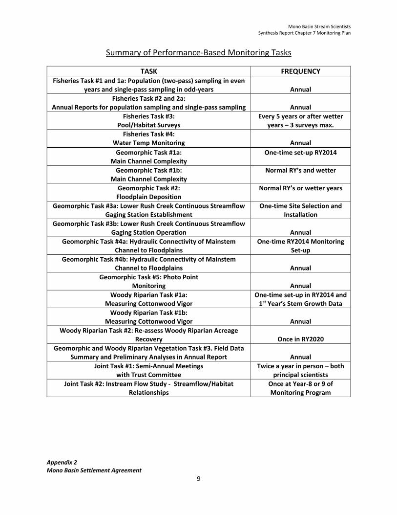
Mono Basin Stream Scientists Synthesis Report Chapter 7 Monitoring Plan
Appendix 2 Mono Basin Settlement Agreement
9
Summary of Performance‐Based Monitoring Tasks
TASK FREQUENCY Fisheries Task #1 and 1a: Population (two‐pass) sampling in even
years and single‐pass sampling in odd‐years
Annual
Fisheries Task #2 and 2a: Annual Reports for population sampling and single‐pass sampling
Annual
Fisheries Task #3: Pool/Habitat Surveys
Every 5 years or after wetter years – 3 surveys max.
Fisheries Task #4: Water Temp Monitoring
Annual
Geomorphic Task #1a: Main Channel Complexity
One‐time set‐up RY2014
Geomorphic Task #1b: Main Channel Complexity
Normal RY’s and wetter
Geomorphic Task #2: Floodplain Deposition
Normal RY’s or wetter years
Geomorphic Task #3a: Lower Rush Creek Continuous Streamflow Gaging Station Establishment
One‐time Site Selection and Installation
Geomorphic Task #3b: Lower Rush Creek Continuous Streamflow Gaging Station Operation
Annual
Geomorphic Task #4a: Hydraulic Connectivity of Mainstem Channel to Floodplains
One‐time RY2014 Monitoring Set‐up
Geomorphic Task #4b: Hydraulic Connectivity of Mainstem Channel to Floodplains
Annual
Geomorphic Task #5: Photo Point Monitoring
Annual
Woody Riparian Task #1a: Measuring Cottonwood Vigor
One‐time set‐up in RY2014 and 1st Year’s Stem Growth Data
Woody Riparian Task #1b: Measuring Cottonwood Vigor
Annual
Woody Riparian Task #2: Re‐assess Woody Riparian Acreage Recovery
Once in RY2020
Geomorphic and Woody Riparian Vegetation Task #3. Field Data Summary and Preliminary Analyses in Annual Report
Annual
Joint Task #1: Semi‐Annual Meetings with Trust Committee
Twice a year in person – both principal scientists
Joint Task #2: Instream Flow Study ‐ Streamflow/Habitat Relationships
Once at Year‐8 or 9 of Monitoring Program
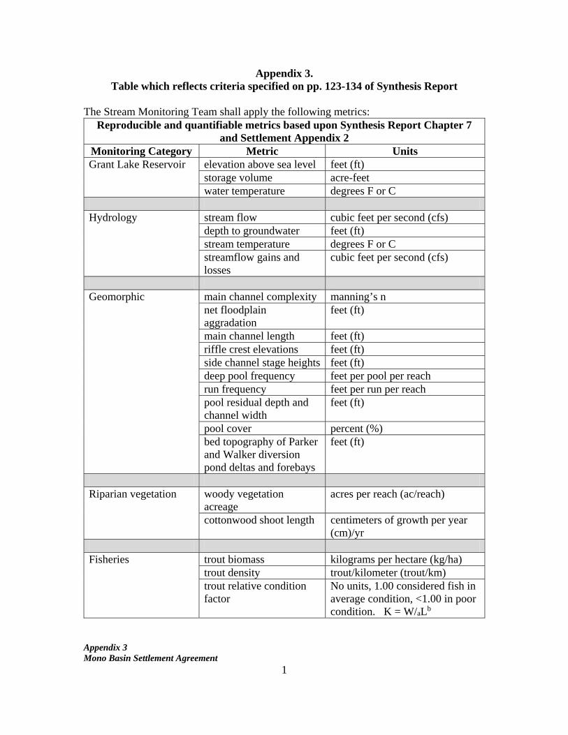
Appendix 3 Mono Basin Settlement Agreement
1
Appendix 3. Table which reflects criteria specified on pp. 123-134 of Synthesis Report
The Stream Monitoring Team shall apply the following metrics:
Reproducible and quantifiable metrics based upon Synthesis Report Chapter 7 and Settlement Appendix 2
Monitoring Category Metric Units Grant Lake Reservoir elevation above sea level feet (ft)
storage volume acre-feet water temperature degrees F or C
Hydrology stream flow cubic feet per second (cfs)
depth to groundwater feet (ft) stream temperature degrees F or C streamflow gains and losses
cubic feet per second (cfs)
Geomorphic main channel complexity manning’s n
net floodplain aggradation
feet (ft)
main channel length feet (ft) riffle crest elevations feet (ft) side channel stage heights feet (ft) deep pool frequency feet per pool per reach run frequency feet per run per reach pool residual depth and channel width
feet (ft)
pool cover percent (%) bed topography of Parker and Walker diversion pond deltas and forebays
feet (ft)
Riparian vegetation woody vegetation
acreage acres per reach (ac/reach)
cottonwood shoot length centimeters of growth per year (cm)/yr
Fisheries trout biomass kilograms per hectare (kg/ha)
trout density trout/kilometer (trout/km) trout relative condition factor
No units, 1.00 considered fish in average condition, <1.00 in poor condition. K = W/aLb
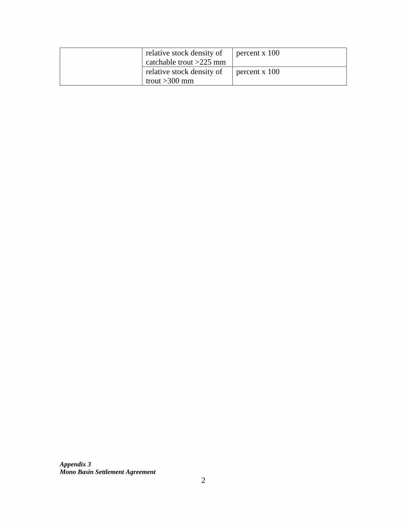
Appendix 3 Mono Basin Settlement Agreement
2
relative stock density of catchable trout >225 mm
percent x 100
relative stock density of trout >300 mm
percent x 100