Embed Size (px)
Citation preview

H E N R YEC L A Y T O N
McDonough
Hampton
Lovejoy
Woolsey
Sunny Side
Wildcat Creek WatershedHUC 10 #0313000501
STATE OF GEORGIA TIER 2 TMDL IMPLEMENTATION PLAN REVISION 1 Wildcat Creek Flint River Basin Local Watershed Governments Spalding County; City of Griffin, City Orchard Hill I. INTRODUCTION
Wildcat Creek
F A Y E T T
Fayetteville
Brooks
Peachtree City
Senoia
Total Maximum Daily Load (TMDL) Implementation Plansare platforms for evaluating and tracking water qualityprotection and restoration. These plans have beendesigned to accommodate continual updates andrevisions as new conditions and information warrant. Inaddition, field verification of watershed characteristics andlisting data has been built into the preparation of theplans. The overall goal of the plans is to define a set ofactions that will help achieve water quality standards inthe state of Georgia. This implementation plan addresses the general
Table 1. IMPAIRMENTS
S P A L D I N G
P I K E L A M A R
Griffin
Williamson
characteristics of the watershed, the sources of pollution,stakeholders and public involvement, andeducation/outreach activities. In addition, the plandescribes regulatory and voluntary practices/controlactions (management measures) to reduce pollutants,milestone schedules to show the development of themanagement measures (measurable milestones), and amonitoring plan to determine the efficiency of themanagement measures.
IMPAIRED STREAM SEGMENT IMPAIRED SEGMENT LOCATION IMPAIRMENT Wildcat Creek Heads Creek to Flint River Fecal Coliform Bacteria Heads Creek * D/S Griffin Reservoir to Wildcat Creek Biota (Sediment) * Plan will be written by GA EPD
1

Plan for Wildcat Creek HUC 10 #: 0313000501
2
II. GENERAL INFORMATION ABOUT THE WATERSHED Write a narrative describing the watershed, HUC 10# 0313000501. Include an updated overview of watershed characteristics. Identify new conditions and verify or correct information in the TMDL document using the most current data. Include the size and location of the watershed, political jurisdictions, and physical features which could influence water quality. Describe the source and date of the latest land cover/use for the watershed. Describe and quantify major land uses and activities which could influence water quality. See the instructions for more information on what to include. Overview At roughly 32,000 acres the Wildcat Creek watershed is a small watershed (< 100 Sq. Miles) located entirely within Spalding County and feeds into the Flint River. The watershed includes the Heads Creek Reservoir that serves as the primary source for public water for Spalding County, two cities within Pike County and the City of Griffin, which also owns and manages the reservoir. Much of the water within the reservoir has been delivered there from the Flint River, where under normal conditions the reservoir has a surface area of 314 acres and a storage volume of 736 MG. The intake at this reservoir has a total hydraulic pumping capacity of 11.9 MGD. Both the Flint River and the Heads Creek reservoir are tested once-twice a week upstream from the intake points. No significant problems or violations have been detected within the past few years. The reservoir and area streams have been subject to extremely low volumes during the recent drought. While this has led to emergency conservation measures and general concerns of litter and debris, there are no major issues with water quality in the reservoir at this time. For the larger watershed of Wildcat Creek there are more dynamic features of urban conditions and land in relatively undeveloped conditions or used for agricultural purposes. The watershed does include portions of the City of Griffin and SunnySide, though both municipalities sit at the headwaters furthest away from the main artery named Wildcat Creek. The inclusion of these more urban areas, however, especially the vast amounts of impervious surface associated with the commercial and industrial development along Highway 41, presents the potential for great impacts from urban runoff and stormwater management. Included in this area are the new Wal-Mart Super Center, Griffin Technical College, numerous commercial strip centers and automotive dealerships and retail stores. On the opposite end of the spectrum, the watershed is decidedly more rural and pastoral as the watershed comes to a close near the Flint River. Some farming operations, particularly for hay and private cattle or horse farming (<50 animals per site), are found within this portion of Spalding County, as is an abundance of large residential lots. The most notable wetlands within the watershed also occur south of the reservoir, leading into the main artery of Wildcat Creek.

Plan for Wildcat Creek HUC 10 #: 0313000501
3
Verification of TMDL Conditions With the assistance of stakeholders and the local governments, the MTRDC tried to evaluate the accuracy of watershed conditions established in the TMDL. This included the collection of background information and performance of field surveys for comparison with and confirmation of the TMDL data. Assessment of the land use characteristics was done comparing various GIS datasets with the information used in the original TMDL. The TMDL assessment of land coverage within the watershed was based on the Georgia Multiple Resolution Land Coverage (MRLC), which utilizes Landsat Thematic Mapper digital images developed in 1995 and updated in 2001. This coverage provides land use categories in a modified Anderson level one and two system. The comparable dataset used by the MTRDC is a 1996 land cover file produced by the Georgia Department of Natural Resources (DNR) using the same system. For additional evaluation the MTRDC also reviewed the most recent local Existing Land Use files for each community involved. These files are based on 2003 parcel-level records maintained by the MTRDC and based upon common zoning and land use classifications. Land Cover 1996 2001 Forest
62.19% 62.42%Pasture / Hay 17.19% 16.88% Row Crops 5.92% 5.94% Low Intensity Residential 4.41% 0.00% Woody Wetlands 4.15% 4.14% Commercial / Industrial / Transportation 2.02% 2.02% Urban / Recreational Grasses 1.56% 1.64% Open Water 1.44% 1.44% High Intensity Residential 0.99% 5.40% Emergent Herbaceous Wetlands
0.06% 0.06%
Transitional 0.05% 0.05% The only notable difference between the land cover data for 1996 and 2001 is the change in residential conditions, where all the residential lands were reclassified from Low to High Intensity. Some of this may be due to newer structures in the watershed being built closer to existing structures, changing the dynamic from a rural setting to more suburban. This might also be due to reclassification of lot conditions depending on the changes to land use and activity surrounding the structure. The net change is negligible, however, and reviewing the actual conditions within the watershed confirms that residential use accounts for a very small amount of activity. As discussed above, virtually all of the urban uses occur at the headwaters, with Highway 41 acting as the symbolic boundary of the watershed.

Plan for Wildcat Creek HUC 10 #: 0313000501
4
WILDCAT CREEK - Existing Land Use (2004) Low Density Residential: 12,345 38.7% Agriculture / Residential: 7,943 24.9% Undeveloped / Unused: 6,706 21.0% TCU: 1,579 4.9% Medium Density Residential: 1,324 4.1% Public Institutional: 890 2.8% Commercial: 812 2.5% Industrial: 188 0.6% High Density Residential: 136 0.4% Among the most distinguishing characteristics or sites within the watershed are the Shoal Creek Landfill and the Shoal Creek Land Application Site (LAS), both of which occur on properties with arterial streams that feed into Wildcat Creek. The LAS, one of three wastewater treatment facilities owned and operated by the City of Griffin, was opened in 1998 as part of an expansion/relocation effort to upgrade capacity to 2.25 MGD. The City has recognized problems with odor and infiltration/inflow for this facility, but has not identified any major events to suggest a direct contamination of the nearest stream. The landfill, currently about 14 acres but expanding, is for construction and demolition debris, compost and inert waste. This facility has an anticipated lifespan of 25+ years and has not been cited for water or groundwater pollution concerns. Additional sites critically observed for this study include properties used for agricultural testing by the University of Georgia Griffin Campus, a private golf course, four schools, a major recreational park and several multi-family complexes. The UGA facilities represent the most intensive agricultural activity within the watershed. While several grazing areas and farms were detected, none exhibited commercial or large-scale operations. Further, the UGA Griffin Campus does not house any agricultural livestock within the watershed. The College has been active in the community in advocating environmental stewardship and works with area schools, garden clubs and the City’s stormwater department in providing educational resources and sessions for community residents. An additional resource reviewed was the Source Water Assessment Program (SWAP) report performed by the MTRDC for the Potato Creek watershed in 2002. As part of a regional assessment of water supply resources, this purpose of this study was to identify and evaluate potential pollution sources within the watershed. These SWAP reports also evaluated land use and land cover characteristics as well as trends in development and water quality monitoring. On a scale of Low, Medium and High the SWAP report for the Heads Creek Watershed produced an overall rating of Medium for susceptibility to contamination from non point sources, based largely on the volume of bridges and road crossings that provided an opportunity for chemicals to enter the water body through runoff. The only other primary potential pollution sources within the watershed were several gas stations with underground storage facilities. Current conditions have not shown any of the potential sources identified to be an immediate major threat or to be contributing to current problems with fecal coliform. Field Surveys were also done to assess the state of the watershed and to identify conditions that might serve the impairment of the stream segment. Between February and May of 2004 MTRDC staff drove along every public roadway within the watershed, looking for land use and development activity near and along stream banks that might contribute to a pollution problem.

Plan for Wildcat Creek HUC 10 #: 0313000501
5
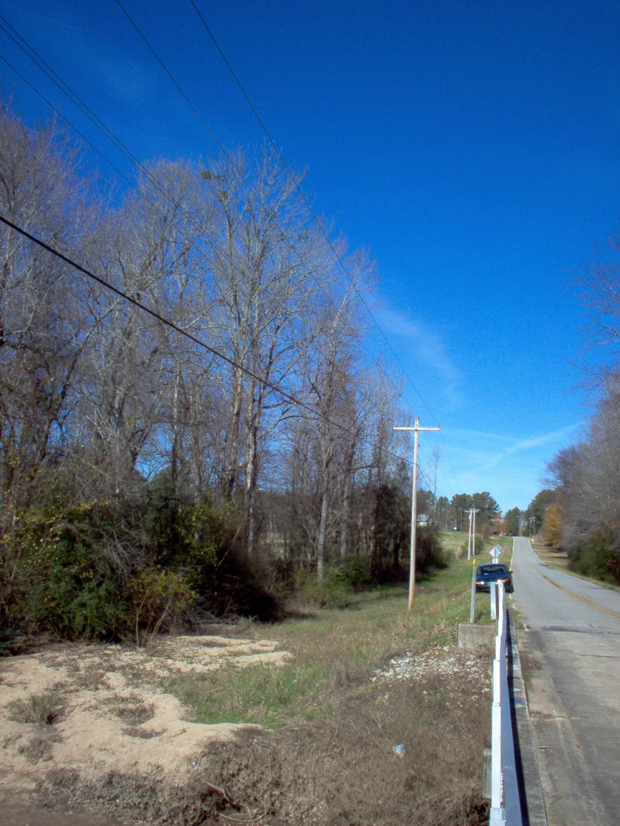
• Conditions of riparian areas – Fair to good. Much of the watershed appears environmentally sound and much of the wetlands and
flood plains appear undisturbed. • Conditions of stream banks – Fair to good. Only a few small sections of stream bank appear worn from erosion and/or intrusion. • Observe any fish – Yes. Unable to discern general health or growth, but there were notable concentrations of fish. • Water quality and clarity – Poor to good. Some patches of the creek were cloudy and several smaller tributaries near the
headwaters in the urban areas were visibly discolored from oils and other pollutants. Closer to the convergence of the Heads Creek and Wildcat Creek the water becomes increasingly clearer.
• Ditches capable of draining into the stream – Several ditches were noticed within the urbanized areas, most appearing as small/modest, older channels for directing stormwater away from the principal structure. None observed along the main route of Wildcat Creek west of the landfill.
• Buffer requirements – No clear violations of stream-buffer requirements were detected, though there was anecdotal evidence of land disturbance that may have come within 25-50 feet of the stream banks.

Plan for Wildcat Creek HUC 10 #: 0313000501
6
{Wildcat Creek}
COMPLETE THE FOLLOWING TABLES FOR AND NARRATIVES ABOUT EACH IMPAIRED STREAM IN THE WATERSHED.
STREAM SEGMENT NAME LOCATION MILES/AREA DESIGNATED USE PS/NS Wildcat Creek Heads Creek to Flint River 2 miles Fishing NS III. SOURCES AND CAUSES OF STREAM SEGMENT IMPAIRMENT LISTED IN TMDLs After reviewing the TMDLs written for this stream, complete the following tables with the information found in the TMDLs. List each parameter for which the stream segment is impaired and the water quality standard violated. See the instructions for the water quality standards. Describe the sources and causes of each violation identified in the TMDLs.
Table 2. SOURCES OF IMPAIRMENT AS INDICATED IN TMDLs PARAMETER 1 WQ STANDARD SOURCES OF IMPAIRMENT NEEDED REDUCTION FROM
TMDL Fecal Coliform 1,000 per 100 ml
(geometric mean Nov-April) 200 per 100 ml (geometric mean May-Oct)
Wildlife Agricultural Livestock Urban Development
57%

Plan for Wildcat Creek HUC 10 #: 0313000501
7
IV. IDENTIFICATION AND RANKING OF POTENTIAL SOURCES OR CAUSES OF IMPAIRMENT INVESTIGATE AND EVALUATE the sources of impairment for each parameter listed in Table 2. Write a narrative describing efforts made or procedures used to verify the significance and extent of the sources or causes of each impairment listed in the TMDLs. Include: - Involvement of stakeholder group - Field surveys - Review of land cover data - Evaluation of sources Narrative of Procedures The following measures were employed to help identify and evaluate potential sources or causes of impairment:
Review of land cover/land use data – The McIntosh Trail RDC (MTRDC) worked with local tax and zoning offices to acquire and/or update land use and land cover information regarding the watershed. A 1996 land cover file was used for base information, which was then reviewed against parcel and development information current through March of 2004. Included in this assessment, where possible, was information concerning sewer service areas and the distribution of sewer lines. Where possible, data for impervious surface was used. Copies of this information were available for review at all public hearings and through the MTRDC offices. A major part of this step included the development of more specific data concerning general land use types. For instance, properties under the common category of Transportation, Communication and Utilities included the landfill, LAS site and reservoir. Identifying sites with unique or special conditions related to their potential impact on water quality in the watershed were recognized for special field surveys, where possible. Additional amendments included updates of land use information, new subdivisions and/or lot splits, and identification of main sewer lines. Field surveys – MTRDC staff performed windshield surveys of the watershed and, where possible, walked along stream corridors. These surveys were used to verify land use/land cover information, to identify potential sources of impairment and to assess the overall quality of the watershed and stream banks. Procession along the stream corridors was prohibited in many areas due to private property/trespassing concerns, and concentrated on the arterial streams involved in the TMDL planning process. MTRDC staff traveled along all of the paved public roads within the watershed, noting areas that may exhibit the potential for significant pollution problems. Several concentrations of older housing that rely on septic systems were targeted for future monitoring, as well as open fields that harbor livestock and appear susceptible to runoff problems. Staff also walked along the banks for several portions of the stream below the reservoir, examining the general quality of the bank, clarity of the water and searching for potential sources of contamination. In some instances it appeared the removal of surrounding vegetation for newer residential development in the southernmost portions of the watershed left stream banks moderately exposed; Though buffers were maintained and erosion control measures were in place, the changes in general topography and ground cover allowed runoff to reach the stream must more quickly and directly.

Plan for Wildcat Creek HUC 10 #: 0313000501
8
Involvement of stakeholders – (See also Section V, Stakeholders) The initial outreach and field surveys, MTRDC staff interviewed various property owners and spoke with City of Griffin staff concerning potential pollution sources. In most instances the prevalence of wildlife and the possibility of leaking wastewater systems, septic or sewer, were raised. However, it should be noted that no leaks were found within the public sewer system in this watershed during the planning process or in recent history. Also, because the City is required to monitor the health of the Heads Creek watershed and maintain the quality of the water flowing from the reservoir, a larger portion of the focus for this plan shifted to the remainder of the Wildcat Creek watershed. An additional public hearing opportunity for general input on the plan was unattended in May.
Evaluation of sources – For each impairment identified there are conditions that suggest specific sources for that impairment. With fecal coliform the potential sources must include the production and/or management of human or animal waste. Where the planning process for this TMDL identified potential pollution source conditions, such as septic systems, animal farms, etc, each site was evaluated for its potential contribution to the impairment. The following conditions are cited are potential sources contributing to the pollution problem: Wildlife – Bordering on even more expansive and pristine rural habitats, Spalding County does exhibit a modest/high deer population as well as volumes of raccoons, birds and other wildlife for a metropolitan county. Many of the residents with larger lots within the watershed have noted deer on their property and cited the interaction with such wildlife as a popular attraction for the area. It should also be noted that Spalding County is regarded as having a high number of stray dogs, including the county’s west side. In the absence of notable sites for agricultural livestock and urban development, wildlife appears the largest contributor to the fecal coliform problem. Agricultural livestock – While several grazing areas were observed within the Wildcat Creek watershed, none were considered of significant size or scale to be the sole source of the pollution problem. Most of the livestock within the area are kept for hobby farms and personal care. Most of these properties appeared populated with horses, though the overall volume of livestock would favor cattle. As a matter of potential pollution concerns, the issue here may be one of access for livestock or stormwater runoff to reach the stream banks, as the volume of animals within the watershed does not appear egregious. Urban Development – As noted before, there are significant concentrations of urban development along the watershed’s eastern boundary. This includes large scale commercial operations with extensive amounts of impervious surface as well as various scales of residential development with highly manicured greenspace. The City of Griffin recently completed an update to its comprehensive plan, which included references to the capacity and performance of their sewer system. For the lines and the LAS within the Wildcat Creek watershed there have been no significant problems reported that suggest the system is a regular, primary contributor to stream impairment. This does not preclude further examinations of lines and facilities, but does reflect the City’s commitment as an NPDES community to monitor and maintain their system so as to preserve the quality of the watershed. Additional field surveys beyond those allowed by this planning process must be done on a regular basis to monitor the potential impacts of the landfill and major developments. Property owners must also regularly monitor and maintain their individual septic systems, livestock fields and facilities, and soil applications to prevent the possibility of runoff contaminating local streams. Staff from the local Farm Bureau suggested that most, if not all, agricultural operations in the Griffin area are aware of best management practices and the critical nature of water quality in the Flint River Basin.
Plan for Wildcat Creek HUC 10 #: 0313000501
9
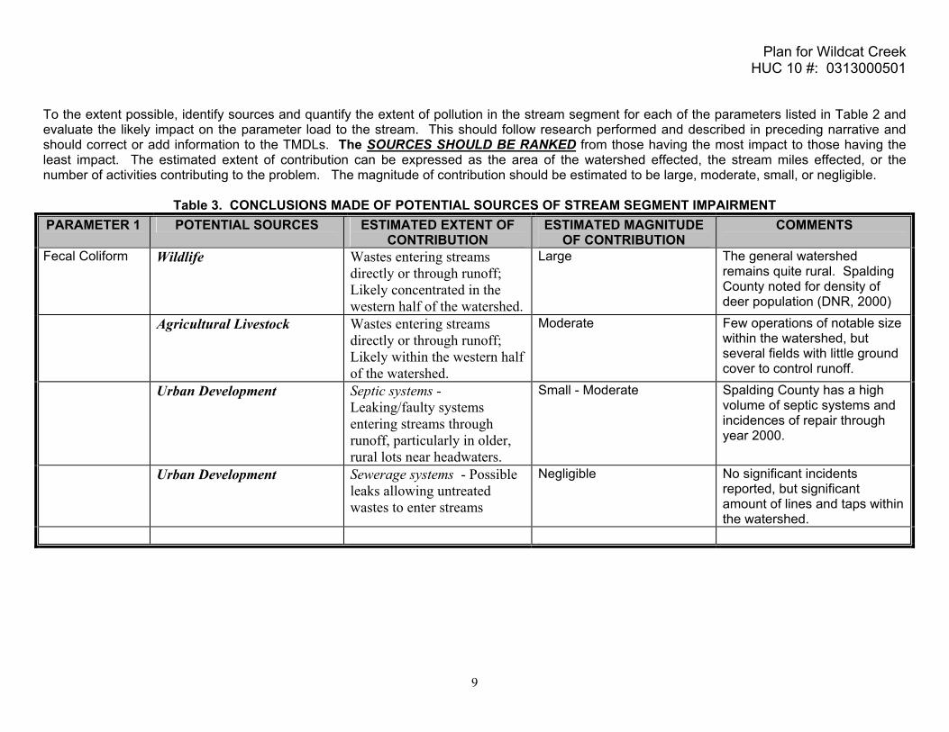
To the extent possible, identify sources and quantify the extent of pollution in the stream segment for each of the parameters listed in Table 2 and evaluate the likely impact on the parameter load to the stream. This should follow research performed and described in preceding narrative and should correct or add information to the TMDLs. The SOURCES SHOULD BE RANKED from those having the most impact to those having the least impact. The estimated extent of contribution can be expressed as the area of the watershed effected, the stream miles effected, or the number of activities contributing to the problem. The magnitude of contribution should be estimated to be large, moderate, small, or negligible.
Table 3. CONCLUSIONS MADE OF POTENTIAL SOURCES OF STREAM SEGMENT IMPAIRMENT PARAMETER 1 POTENTIAL SOURCES ESTIMATED EXTENT OF
CONTRIBUTION ESTIMATED MAGNITUDE
OF CONTRIBUTION COMMENTS
Fecal Coliform Wildlife Wastes entering streams directly or through runoff; Likely concentrated in the western half of the watershed.
Large The general watershed remains quite rural. Spalding County noted for density of deer population (DNR, 2000)
Agricultural Livestock Wastes entering streams directly or through runoff; Likely within the western half of the watershed.
Moderate Few operations of notable size within the watershed, but several fields with little ground cover to control runoff.
Urban Development Septic systems - Leaking/faulty systems entering streams through runoff, particularly in older, rural lots near headwaters.
Small - Moderate Spalding County has a high volume of septic systems and incidences of repair through year 2000.
Urban Development Sewerage systems - Possible leaks allowing untreated wastes to enter streams
Negligible No significant incidents reported, but significant amount of lines and taps within the watershed.

Plan for Wildcat Creek HUC 10 #: 0313000501
10
V. STAKEHOLDERS PUBLIC INVOLVEMENT AND THE ACTIVE PARTICIPATION OF STAKEHOLDERS is essential to the process of preparing TMDL implementation plans and improving water quality. Stakeholders can provide valuable information and data regarding their community, impaired water bodies, potential causes of impairments, and management practices and activities which may be employed to reduce the impacts of the causes of impairment. Describe outreach activities to advise and engage stakeholders in the TMDL implementation plan preparation process. Describe the stakeholder group employed or formed to address the impaired segments in the watershed. Summarize the results of the number of attendees and meetings and describe major findings, recommendations, and approvals. Initial outreach to key stakeholders involved direct communication and surveys of potential water quality issues and one general public hearing in May that was unattended. Copies of the initial watershed evaluation, which included the basic watershed profile and preliminary assessment of potential sources of impairment, were made available for public review in June of 2004. Before the draft Plan is approved, continuing outreach regarding the TMDL planning process will include further public hearings and direct follow up with key stakeholders in the impacted communities. Staff from the City of Griffin and Spalding County were consulted early in 2004 for input on the land use/land cover information, the performance of the sewer system and potential sources of contamination. The City of Griffin Public Works Department, which is responsible for the reservoir and all sewer lines and facilities, will be regularly advised of all progress with the plan and feature strong input on the resulting management measures and activities. The names of several businesses, land owners and other key stakeholders were sought from the Farm Bureau and the Griffin Area Chamber of Commerce. Members of each were invited to meet with MTRDC staff and offer input, questions and comments in the initial outreach phase of the process. The draft plan will also be made available to these agencies and their members for additional review and comment. The MTRDC has a standing Environmental Advisory Committee that proved critical to the development of the region’s original TMDL implementation plans. In addition to least two representatives from each member county serving on the Committee, officials from local water and sewer authorities are regularly invited to participate, as well as other identified stakeholders as requested by local leaders. Members were consulted as part of the general outreach of this process and will be invited to comment, if not convene, for further review of the draft plan. The MTRDC Board, which also features representation from all member counties, has also been appraised of the program efforts and allowed to comment and participate in the planning process, but no one from this board has made any suggestion regarding Wildcat Creek. A consistency among the comments and recommendations was the suggestion that the violations shown in the original TMDL appear isolated in nature and may not be indicative of the stream’s regular state. If there is in fact a consistent problem it was also suggested

Plan for Wildcat Creek HUC 10 #: 0313000501
11
that natural wildlife may be the largest contributor, specifically the local deer population. There was no immediate recognition of likely sources among agricultural operations or obvious leaks from septic or sewer systems, save for unconfirmed suggestions of possible problems associated with the wastewater land application site. Final public hearings for all of the region’s Tier 2 TMDL Plans were held on December 15, 2004 in Griffin and Thomaston. Only 2 persons from the general public attended each hearing, with no new comments presented. Local officials were also given till that day to comment on copies of the plans presented to them within the past month. Several comments suggesting amendments to policy measures and possible magnitudes of contribution from each source were discussed. Any and all comments received up to that day have been incorporated into the plan. Another resource recommended for future inclusion is the recently formed Upper Flint River Basin Stakeholder Committee. Developed within the past year as a means to coordinate activism on behalf of the river and the watershed, this committee includes similar representation of local officials, private interest stakeholder groups, land owners and more. Their objective is to promote the welfare of the river and provide communication and education to inform area decision makers.

Plan for Wildcat Creek HUC 10 #: 0313000501
12
List the watershed or advisory committee members of the stakeholder group for this segment in the following table.
Table 4. COMMITTEE MEMBERS
NAME/ORG ADDRESS CITY STATE ZIP PHONE E-MAIL Chuck Taylor, Spalding County
PO Box 1087 Griffin GA 30224 770.467.4233 [email protected]
Hameed Malik, City of Griffin
PO Box T Griffin GA 30224 770.229.6424 [email protected]
Mr. Van Whaler Butts County
25 Third Street, Suite 4
Jackson GA 30233 770.775.8200
Mr. Patrick Comiskey City of Thomaston
P. O. Box 672
Thomaston GA 30286 706.647.4242
Mr. Clay Ross City of Zebulon
P. O. Box 385
Zebulon GA 30295 770.567.8748
Mark Bryant Upson County
106 East Lee St. Suite 110
Thomaston GA 30286 706.647.7012
Mrs. Marcie Seleb Butts County Water Auhtority
P. O. Box 145
Jackson GA 30233 770.775.0042
Mr. Reggie Watson Barnesville Water Department
109 Forsyth Street
Barnesville GA 30204
Mr. Bobby Burnette Lamar County
326 Thomaston Street Barnesville GA 30204 770.358.5146
Mr. Tommy Burnsed Interim County Manager
PO Box 377 Zebulon GA 30295 770.567.3406
Mr. Charles Absher Integrated Science and Engineering
275 South Lee Street
Fayetteville GA 30214
* The above list represents those stakeholders who will be included as part of all regular environmental Advisory Committee meetings regarding this and other local TMDL initiatives. They have been selected for their relationship to the watershed and their position in community. Additional stakeholder, see Appendix A, will be allowed input and participate in public and watershed specific forums. In Appendix A, list the names, addresses, telephone numbers, and e-mail addresses for local governments, agricultural or commercial forestry organizations, significant landholders, businesses and industries, and local organizations including environmental groups and individuals with a major interest in this watershed.

Plan for Wildcat Creek HUC 10 #: 0313000501
13
VI. MANAGEMENT MEASURES AND ACTIVITIES Describe any management measures or activities that have been put into place or will be put into place including regulatory or voluntary actions or other controls by governments or individuals that specifically apply to the pollutant that will help achieve water quality standards. Include who will be responsible for the measure, how it will be funded, the status, the date it will be or was initiated, and a short description of how effective the measure is or will be.
Table 5. MANAGEMENT MEASURES AND ACTIVITIES
GENERAL MEASURES APPLICABLE TO ALL PARAMETERS
MEASURE RESPONSIBILITY DESCRIPTION SOURCE OF FUNDING
STATUS ENACTED/ IMPLEMENTED
EFFECTIVENESS (Very, Moderate,
Weak) Local Codes/ Zoning Ordinances
Local Government Environmental regulations and stream buffer requirements (DNR Part V)
NA In Place 2001 Very
Development Regulations Local Government
Minimum erosion and sedimentation control measures
NA In Place 1996 Moderate
Land Use Planning Local Government
Adopted Land Use/ Future Land Use plan
NA In Place 2000 Moderate
Illicit Discharge Ordinances & regulations
City of Griffin
Discharge permit standards; Water quality monitoring & testing; Reporting standards
NA In Place 2000 Moderate
Flint River Basin Plan Ga. EPD
State plan for monitoring and managing Flint River basin protective measures
NA In Place 1997 Moderate
Discharge Regulations Ga. EPD
Discharge permitting and management
NA In Place 1995 Very
Source Water Assessment Plan
MTRDC Watershed plan for the Heads Creek Reservoir NA In Place 2002 Moderate

Plan for Wildcat Creek HUC 10 #: 0313000501
14
NPDES Phase II MS4 Municipal Stormwater Permit
Local Government Requires jurisdiction to have a comprehensive stormwater program, which includes public education and participation, illicit discharge detection and elimination, construction site runoff control, post construction runoff control, pollution prevention, permitting and reporting, and program implementation plans.
In Place The goals of this program are designed to improve water quality conditions and/or prevent further degradation of water quality and biotic integrity in the impaired stream corridor.
Local County Stormwater Management Ordinance
Local County Control stormwater runoff to the MS4 within unincorporated areas of Clayton County
In Place (Griffin); Proposed (Spalding)
Provides consequencesfor illicit discharges and connections to the MS4.
Adopt the Georgia Stormwater Management Manual (GSMM)
Local County Government
Adopt the Georgia Stormwater Management Manual (GSMM) as the county’s stormwater design manual. The county and cities may also develop an addendum to the manual which has county specific requirements that are not covered by the GSMM.
In Place (Griffin); Proposed (Spalding)
Stormwater Ordinance
Local County Planning & Zoning
Ordinance to address non-point source pollution.
In Place (Griffin); Proposed (Spalding)
Gives the inspectors a way to address non-point source pollution that is discharged into the MS4 system.
Stormwater Management Audit / Assessment
Local County Government
Internal assessment of stormwater pollution prevention plan (map of facility and responsibilities for upkeep): including but not limited to septic system controls, storm drain system cleaning, stormwater detention basins maintenance, alternative products, hazardous materials storage, road salt application and storage, spill response and prevention, used oil recycling, materials management, leaking fluids from vehicles, and street sweeping.
In Place (Griffin); Proposed (Spalding)
The county needs to ensure that they are meeting all applicable stormwater requirements.
Stormwater BMP Guidance Document for Municipal Operations
Local County Government
Following the audit / assessment, prepare a BMP procedures and guidance manual for County and the cities’ departments to minimize impact of municipal operations on stormwater runoff. This document should address all of the activities identified in the audit / assessment and focus on any common problem areas identified.
In Place (Griffin); Proposed (Spalding)
Local County Land Development Guidelines
Local County Includes stormwater quantity and quality requirements for new developments
In Place Requires post-development controls for stormwater quantity and quality intended to reduce stormwater pollution loads from new developments.

Plan for Wildcat Creek HUC 10 #: 0313000501
15
MEASURES APPLICABLE TO INDIVIDUAL PARAMETERS
PARA-METER 1
MEASURE RESPONSIBILITY DESCRIPTION SOURCE OF
FUNDING
STATUS ENACTED/ IMPLEMENT-
ED
EFFECTIVENESS (Very, Moderate,
Weak)
Fecal Coliform
Local Codes/ Zoning Ordinances
Local Government
Review of land use regulations governing septic tanks & waste management
NA In Place 2005 Moderate
Fecal Coliform
Best Management Practices
Local Government, Farm Bureau
Review & promotion of implementation for livestock & animal waste control efforts within watershed
DNR Proposed 2006 Moderate - Very
Fecal Coliform
Best Management Practices
Local Government, Ga Forestry
Review & promotion of implementation for erosion and sediment control efforts within watershed
Ga Forestry, DNR Proposed 2006 Moderate - Very
Fecal Coliform
Septic System Monitoring
Local Government, DNR
Inventory of properties w/septic systems within the watershed; Study of conditions, age and reports of system repairs within the watershed
Grant, DNR Proposed 2006 2007 Moderate
Fecal Colifrom
Septic System Management
Local Government, DNR
Promotion of system maintenance. Local, DNR Proposed 2006 2007 Moderate
Fecal Coliform Wildlife Monitoring
Local Government Evaluation of wildlife habitat within the watershed DNR, Local Proposed 2006
2007 Weak
Fecal Coliform
Sewer System Maintenance
Local Government Monitoring and maintenance of sewer system facilities and lines Local In
Progress - Very
Plan for Wildcat Creek HUC 10 #: 0313000501
16
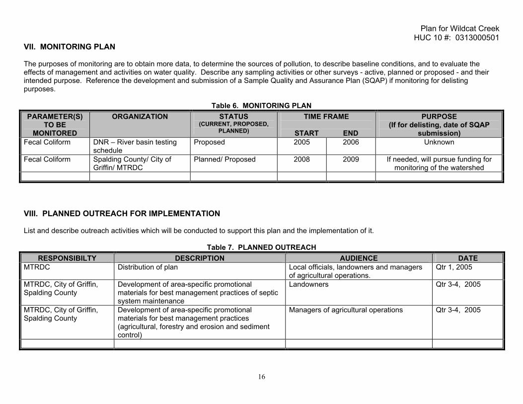
VII. MONITORING PLAN The purposes of monitoring are to obtain more data, to determine the sources of pollution, to describe baseline conditions, and to evaluate the effects of management and activities on water quality. Describe any sampling activities or other surveys - active, planned or proposed - and their intended purpose. Reference the development and submission of a Sample Quality and Assurance Plan (SQAP) if monitoring for delisting purposes.
Table 6. MONITORING PLAN PARAMETER(S)
TO BE MONITORED
ORGANIZATION STATUS (CURRENT, PROPOSED,
PLANNED)
TIME FRAME
START END
PURPOSE (If for delisting, date of SQAP
submission) Fecal Coliform DNR – River basin testing
schedule Proposed 2005 2006 Unknown
Fecal Coliform Spalding County/ City of Griffin/ MTRDC
Planned/ Proposed 2008 2009 If needed, will pursue funding for monitoring of the watershed
VIII. PLANNED OUTREACH FOR IMPLEMENTATION List and describe outreach activities which will be conducted to support this plan and the implementation of it.
Table 7. PLANNED OUTREACH
RESPONSIBILTY DESCRIPTION AUDIENCE DATE MTRDC Distribution of plan Local officials, landowners and managers
of agricultural operations. Qtr 1, 2005
MTRDC, City of Griffin, Spalding County
Development of area-specific promotional materials for best management practices of septic system maintenance
Landowners Qtr 3-4, 2005
MTRDC, City of Griffin, Spalding County
Development of area-specific promotional materials for best management practices (agricultural, forestry and erosion and sediment control)
Managers of agricultural operations Qtr 3-4, 2005

Plan for Wildcat Creek HUC 10 #: 0313000501
17
IX. MILESTONES/ MEASURES OF PROGESS OF BMPs AND OUTREACH This table will be used to track and report progress of management measures including BMPs and outreach. Record milestone dates for: - accomplishment of management practices or activities - outreach activities - installation of BMPs to attain water quality standards. Comment on the effectiveness of the management measure, how much support the measure was given by the community, what was learned, how the measure might be improved in the future, and any other observations made. This table can be "pulled out" of this template and used to report and track progress.
Table 8. MILESTONES MANAGEMENT MEASURE RESPONSIBLE
ORGANIZATIONS STATUS
PROPOSED INSTALLED COMMENT
Distribution of TMDL Plan MTRDC Review of land use regulations governing septic tanks & waste management
Spalding County, City of Griffin, MTRDC
2005
Review & promotion of implementation for livestock & animal waste control efforts within watershed
Spalding County, City of Griffin, Farm Bureau, MTRDC
2006
Review & promotion of implementation for erosion and sediment control efforts within watershed
Spalding County, City of Griffin, Ga Forestry, MTRDC 2006
Inventory of properties w/septic systems within the watershed; Study of conditions, age and reports of system repairs within the watershed
Spalding County, City of Griffin, DNR, MTRDC
2005 2006
Promotion of system maintenance. Spalding County, City of Griffin, DNR, MTRDC
2006 2007
Evaluation of wildlife habitat within the watershed
Spalding County, City of Griffin, MTRDC
2006 2007
Monitoring and maintenance of sewer system facilities and lines
Spalding County, City of Griffin, -

Plan for Wildcat Creek HUC 10 #: 0313000501
18
PROJECTED ATTAINMENT DATE
The projected date to attain and maintain water quality standards in this watershed is 10 years from acceptance of the TMDL Implementation Plan by Georgia EPD.
◊
1999 2000 2001 2002 2003 2004 2005 2006 2007 2008 2009 2010 2011 2012 2013 2014 2015 2016
Scheduled EPD basin Group Monitoring TMDL Completed
TMDL Implementation Plan Accepted ◊ Evaluation of implementation plan/water quality improvement Project Attainment
Prepared By: Adam Hazell, AICP; Planning Director
Agency: McIntosh Trail Regional Development Center PO Box 818, 120 North Hill Street Address:
City: Griffin ST: ZIP:GA 30224 E-mail: [email protected] Submitted to EPD: December 15, 2004 Revision: 1
The preparation of this report was financed in part through a
grant from the U.S. Environmental Protection Agency under the provisions of Section 106 or Section 604(b) of the Federal Water
Pollution Control Act, as amended.

Plan for Wildcat Creek HUC 10 #: 0313000501
19
APPENDIX A.
STAKEHOLDERS List the names, addresses, telephone numbers, and e-mail addresses for local governments, agricultural or commercial forestry organizations, significant landholders, businesses and industries, and local organizations including environmental groups and individuals with a major interest in this watershed.
NAME/ORG ADDRESS CITY STATE ZIP PHONE E-MAIL Spalding County PO Box 1087 Griffin GA 30224 770.467.4233 City of Griffin PO Box T Griffin GA 30224 770.229.6425 [email protected] Griffin-Spalding Chamber of Commerce
134 North Hill Street Griffin GA 30224 770.228.8200 [email protected]
Griffin-Spalding Development Authority
109 East Solomon Street Griffin GA 30224 770.412.9200 [email protected]
Keep Griffin-Spalding Beautiful
159 Creekwood Drive Griffin GA 30223 770.228.7547
Georgia Farm Bureau PO Box 7068 Macon GA 31210 478.474.8411 Spalding County Water Department
119 East Solomon Street, 110 Courthouse Annex
Griffin GA 30224 770.467.4208
McIntosh Trail RDC PO Box 818 Griffin GA 30224 770.227.6300 [email protected] UGA Griffin Campus 1109 Experiment Street Griffin GA 30223 770.228.7225 Towaliga Soil & Water Conservation District
333 Phillips Drive McDonough GA 30252 [email protected]
Georgia Forestry Commission
2362 Ethridge Mill Road Griffin GA 30224 770.229.3475 [email protected]
Georgia Forestry Commission
1599 Hwy 42 South McDonough GA 30252 770.504.2238 [email protected]
Two Rivers Resource and Conservation District
900 Dallas Street LaGrange GA 30240 [email protected]
Griffin Technical College 501 Varsity Road Griffin GA 30223 770.228.7348 Bruce Ballard, Griffin-Spalding School Board
216 South 6th Street Griffin GA 30224 770.229.3710
Spalding Co. Health Dept.
PO Box 129 Griffin GA 30224
Spalding Co. Extension Service
PO Box 277 Griffin GA 30224 770.467.4225
Larry Walker, Weyerhauser
P. O. Box 238
Oglethorpe GA 31068

Plan for Wildcat Creek HUC 10 #: 0313000501
20
Carmen Westerfield, USDA Natural Resources & Conservation Srvs
118 Academy Drive, Suite D
Barnesville
GA 30204

Plan for Wildcat Creek HUC 10 #: 0313000501
21
APPENDIX B.
UPDATES TO THIS PLAN Describe any updates made to this plan. Include the date, section or table updated, and a summary of what was changed and why.