Embed Size (px)
Citation preview
Initial Study for Application 31021 Page 1
STATE WATER RESOURCES CONTROL BOARD
DIVISION OF WATER RIGHTS P.O. BOX 2000
SACRAMENTO, CA 95812-2000
INITIAL STUDY/ MITIGATED NEGATIVE DECLARATION
I. Background
PROJECT TITLE: Application to Appropriate Water
APPLICATION: 31021
APPLICANT: David, Gary, and Alice Martinelli 1150 Stage Gulch Road Petaluma, CA 94954
APPLICANT’S CONTACT PERSON: Lee Erickson Erickson Engineering Inc. P.O. Box 446 Valley Ford, CA 94972-0446
GENERAL PLAN DESIGNATION: RRD—Land Extensive Agriculture
ZONING: RRD—Land Extensive Agriculture
Introduction
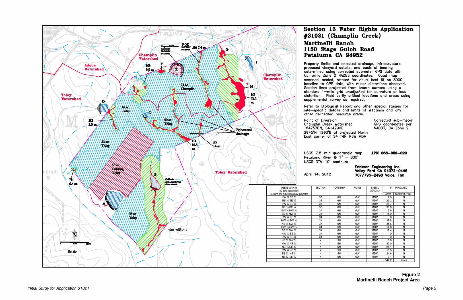
The proposed project area is located at 1150 Stage Gulch Road in the south central portion of Sonoma County, approximately 4 miles southeast of the community of Petaluma and approximately 2 miles west of the town of Schellville (Figure 1). The proposed project area is located in Sections 33, 34, 4, and 3 within Townships 6N and 5N and Range 6W, Mt. Diablo Base and Meridian (MDB&M), on the Petaluma River 7.5-minute U.S. Geological Survey (USGS) topographic quadrangle. The property limit consists of 615 acres, while the Place of Use (POU) for irrigation within the property limit under Application 31021 is 342.2 acres1 (Figure 2). The main access road to the eastern portion of the Ranch is from Petaluma Road to the north (Figure 2). The easternmost part of the property (in Section 34 within Township 6N and Range 6W, MDB&M on the Petaluma River 7.5-minute USGS topographic quadrangle), east of the access road, is steep and will continue to be used for grazing. The surrounding land use to the north and south is vineyard; to the east of the proposed project area is farmland.
1 The total POU shown in Figure 2 includes all of the proposed avoidance areas (i.e., riparian and wetland setbacks/buffers) as well as existing vineyard for the proposed project and thus illustrates less than a 342.2-acre POU (specifically a 254-acre vineyard development potential area).

Initial Study for Application 31021 Page 2
Initial Study for Application 31021 Page 3
Figure 2 Martinelli Ranch Project Area
Initial Study for Application 31021 Page 4
Application 31021 was filed with the State Water Resources Control Board (State Water Board), Division of Water Rights (Division) on January 19, 1999. Application 31021 currently seeks a right to appropriate a total of 45 acre-feet per annum (afa) of water for storage behind an offstream impoundment.
Project Description
The proposed point of diversion (POD) where diversion to offstream storage would occur is located on an Unnamed Stream tributary to Champlin Creek, thence Rodgers Creek, thence Fowler Creek, thence Sonoma Creek, thence San Pablo Bay. The proposed project would involve construction of a sump and pump system that will deliver water to the proposed offstream reservoir, and construction of an earthen impoundment2. Water would be diverted from December 15 through March 31.
The location of the POD is as follows:
Point of Diversion to Storage in Reservoir Adjacent to Unnamed Stream Tributary to Champlin Creek: Located 1847530N and 6414290E. Being within the SW ¼ of the NW ¼ of projected Section 34, Township 5 North, Range 6 West, MDB&M.
Estimated dimensions of the impoundment include maximum effective heights of less than or equal to 23 feet, with approximate semi-circular embankment length of 900 feet, a storage capacity of 45 acre-feet (af), and a surface area of 2.5 acres. Freeboard impoundment height above spillway crest would be 2 feet, and maximum water depth would be 32 feet. The reservoir will be accessed via vineyard avenues on either side. A 10–12-foot side wide graveled surface will be provided on top of the levee for vehicle access purposes. The reservoir, POD, and upland drainages are planned for use as vineyard development, and will therefore not be subject to livestock access.
Water collected to storage pursuant to this application would be used for drip irrigation and recreational purposes. Frost protection, if implemented at all, will occur through mechanical wind machines; no water will be used. Any relatively steep, wet, cold, rocky, or other agronomically undesirable areas will be excluded from vineyard development. Furthermore, wetlands and other sensitive areas would be completely avoided. Wetlands and other sensitive habitats are discussed in detail in the Section 4, Biological Resources. The gross 342.2-acre POU includes essential non-planted areas such as perimeter avenues, staging areas, well and pump sites, and similar improvements, which typically amount to 15–25% of the project footprint. The gross 342.2-acre POU also does not take into account any pre-existing vineyard or riparian
2 Conveyance between the proposed POD and the offstream reservoir is via a 6” underground pipe for a distance of about 700’. Exact POD configuration will be determined when construction drawings are developed. Anticipated components include a bypass weir system, below grade sump, pump station, and associated hardware.
Initial Study for Application 31021 Page 5
and/or wetland setbacks/buffers3. The net POU within the gross 342.2-acre POU (and thus the net POU within the gross 254-acre vineyard development potential area) will be determined in the field by appropriate specialists during initial grading activities.
It is not anticipated that 45 afa would serve the entire POU. Rather, supplemental water for irrigation purposes would be derived from storage in the Existing Non-Jurisdictional Offstream Pond (“A” on Figure 2). Furthermore, all 254 acres will not be developed. In a typical vineyard, edge and avenue effects reduce net plantable acreage by 15–30%. The 254-acre vineyard development potential area provides maximum flexibility in site development. Additionally, since the vineyard would be developed in phases, the mature established plants may not need as much water as the younger vines. Variable irrigation may be used to best allocate limited resources.
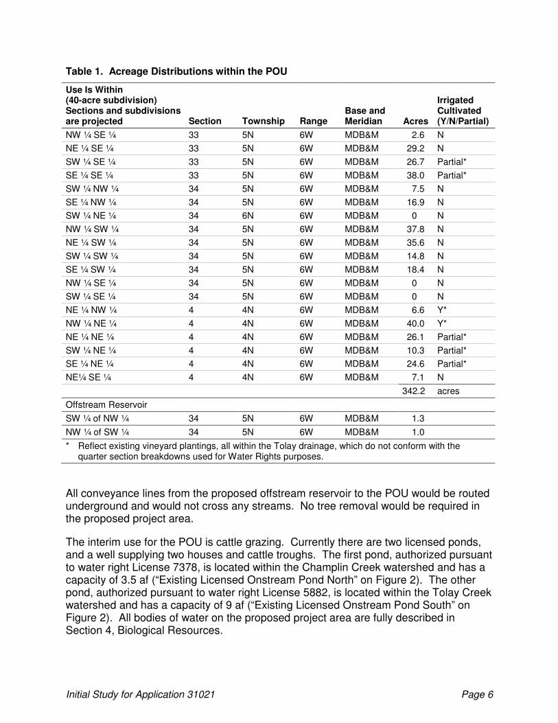
Acreage distributions within the POU are noted in Table 1 below.
3 The 342.2-acre POU has approximately 55 acres of proposed avoidance areas (buffers/setbacks) and 50 acres of pre-existing vineyard. There is also a 43-acre setback surrounding the intermittent Tolay Creek tributary where the Existing Licensed Onstream Pond South (License 5882) (9 af) (“B” on Figure 2) is located. This setback was suggested by the applicant upon filing of the original application, and has never been included as part of the POU. Refer to Section 4, Biological Resources for additional information.
Initial Study for Application 31021 Page 6
Table 1. Acreage Distributions within the POU
Use Is Within (40-acre subdivision) Sections and subdivisions are projected Section Township Range
Base and Meridian
Acres
Irrigated Cultivated (Y/N/Partial)
NW ¼ SE ¼ 33 5N 6W MDB&M 2.6 N
NE ¼ SE ¼ 33 5N 6W MDB&M 29.2 N
SW ¼ SE ¼ 33 5N 6W MDB&M 26.7 Partial*
SE ¼ SE ¼ 33 5N 6W MDB&M 38.0 Partial*
SW ¼ NW ¼ 34 5N 6W MDB&M 7.5 N
SE ¼ NW ¼ 34 5N 6W MDB&M 16.9 N
SW ¼ NE ¼ 34 6N 6W MDB&M 0 N
NW ¼ SW ¼ 34 5N 6W MDB&M 37.8 N
NE ¼ SW ¼ 34 5N 6W MDB&M 35.6 N
SW ¼ SW ¼ 34 5N 6W MDB&M 14.8 N
SE ¼ SW ¼ 34 5N 6W MDB&M 18.4 N
NW ¼ SE ¼ 34 5N 6W MDB&M 0 N
SW ¼ SE ¼ 34 5N 6W MDB&M 0 N
NE ¼ NW ¼ 4 4N 6W MDB&M 6.6 Y*
NW ¼ NE ¼ 4 4N 6W MDB&M 40.0 Y*
NE ¼ NE ¼ 4 4N 6W MDB&M 26.1 Partial*
SW ¼ NE ¼ 4 4N 6W MDB&M 10.3 Partial*
SE ¼ NE ¼ 4 4N 6W MDB&M 24.6 Partial*
NE¼ SE ¼ 4 4N 6W MDB&M 7.1 N
342.2 acres
Offstream Reservoir
SW ¼ of NW ¼ 34 5N 6W MDB&M 1.3
NW ¼ of SW ¼ 34 5N 6W MDB&M 1.0
* Reflect existing vineyard plantings, all within the Tolay drainage, which do not conform with the quarter section breakdowns used for Water Rights purposes.
All conveyance lines from the proposed offstream reservoir to the POU would be routed underground and would not cross any streams. No tree removal would be required in the proposed project area.
The interim use for the POU is cattle grazing. Currently there are two licensed ponds, and a well supplying two houses and cattle troughs. The first pond, authorized pursuant to water right License 7378, is located within the Champlin Creek watershed and has a capacity of 3.5 af (“Existing Licensed Onstream Pond North” on Figure 2). The other pond, authorized pursuant to water right License 5882, is located within the Tolay Creek watershed and has a capacity of 9 af (“Existing Licensed Onstream Pond South” on Figure 2). All bodies of water on the proposed project area are fully described in Section 4, Biological Resources.

Initial Study for Application 31021 Page 7
Project Background
On January 19, 1999, David, Gary, and Alice Martinelli of the Martinelli Ranch (applicant) filed water right Application 31021 with the State Water Board. Application 31021 was accepted on February 29, 2000. As originally filed, Application 31021 requested the diversion of 130 afa to onstream storage as follows: 40 afa to storage at POD 6 (reservoir 6), 49 afa to storage at POD 7 (reservoir 7) and 41 afa to storage at POD 8 (reservoir 8). Water would be used for irrigation and frost protection of 130 acres as well as recreation at the reservoirs. The season of diversion would be from December 15 to March 31 of each year.
The Applicant filed a petition for change, dated September 15, 2005, to (1) increase the POU from 130 acres to 350.1 acres; (2) eliminate two PODs (reservoirs 6 and 8); (3) reduce the requested diversion amount from 130 afa to 45 afa; and (4) remove frost protection use. The petition for change was subsequently amended on December 13, 2006, April 25, 2007 and finally on May 25, 2007 to increase the POU to 366.2 acres. The Applicant further reduced the POU from 366.2 acres to 342.2 acres following a site visit conducted by Division staff on October 20, 2008. Finally, on June 7, 2011 the application was amended to convert POD 7 from an onstream reservoir to a sump and pump system that will deliver water to an offstream reservoir.
A public notice was issued for Application 31021 on June 2, 2000 (State Water Resources Control Board 2000a). One protest was filed against the proposed project at that time by the U.S. Fish and Wildlife Service (USFWS). Following public notice of the petition for change, as modified on May 25, 2007, on August 9, 2007, two additional protests were received from Trout Unlimited of California (TU) and the Department of Fish and Game (DFG). The protest filed by TU was subsequently withdrawn. All other protests remain unresolved.
USFWS sent a protest letter, dated June 28, 2000, expressing their concerns about the proposed project resulting in take of federally listed species (the federally endangered California freshwater shrimp and the threatened California red-legged frog) (Miller 2000). The Division reserved consideration for accepting the protest until after preparation of the environmental document.
TU sent a letter dated September 17, 2007, expressing their concerns about downstream fish habitat being negatively affected by the proposed project. This protest was subsequently withdrawn by Trout Unlimited on December 5, 2007.
DFG filed a protest on September 14, 2007 expressing their concerns that 1) the proposed project may result in direct and cumulative adverse impacts to the resources of the Unnamed Stream tributary to Champlin Creek and the Sonoma Creek watershed by reducing instream flow and water availability that is required to maintain riparian and fish rearing habitat within the drainage and 2) proposed construction work to increase the POU has the potential to significantly impact terrestrial species. The portion of the protest related to the proposed construction work to increase the POU has not been
Initial Study for Application 31021 Page 8
dismissed and the parties will continue protest negotiations as further information becomes available (i.e., this Initial Study).
California Environmental Quality Act (CEQA) Baseline Conditions
The baseline date for this project is February 29, 2000 which reflects ‘no project’ conditions. For the purposes of CEQA review, the project consists of vineyard development, construction of the offstream reservoir and diversion structure, and the diversion and use of 45 afa. Since the time of filing the applicant has developed approximately 50 acres of vineyard after obtaining a Sonoma County Vineyard Erosion and Sediment Control Ordinance (VESCO) application and permit in 2005. The developed vineyard area is irrigated with water collected in an existing 49 acre-foot non-jurisdictional offstream pond (“A” on Figure 2), which was constructed pursuant to Sonoma County Grading Permit GRD 99-0112. The remaining project construction work is scheduled to commence 12 to 24 months after the project is approved and other necessary permits are obtained.
Environmental Setting
The proposed project area is located on a gently sloping watershed divide, encompassing two separate watersheds—Champlin Creek to the north and Tolay Creek to the south (Figure 2). Champlin Creek is tributary to Rodgers Creek, thence Fowler Creek, thence Sonoma Creek thence San Pablo Bay. Tolay Creek drains to San Pablo Bay. Acreage distributions for the total property limit and POU are noted in Table 2 below.
Table 2. Total Property Limit and Acreage Distributions within POU
Designation Champlin Creek
Watershed Tolay Creek Watershed Total
Total Acreage 234 381 615
POU Acreage 107.1 235.1 342.2
Vineyard Development Potential w/in POU 74 180 254
Of the 615 acre property limit, 234 acres are located in the Champlin Creek watershed, and 381 acres are located in the Tolay Creek watershed. Irrigation of approximately 107 acres could occur in the Champlin Creek watershed. While irrigation of approximately 235 acres could occur in the Tolay Creek watershed, no direct diversion or storage would occur in the Tolay Creek watershed under Water Right Application 31021. Application 31022, on file with the Division, seeks diversion and storage of water in the Tolay Creek watershed4. Figure 2 shows the areas where vineyard
4 Per permission of the State Water Board, Application 31021 and Application 31022 will be processed separately because the project applicant, David Martinelli, wishes to defer active pursuit of the Application 31022 until all issues pertaining to diversions amounts under Application 31021 have been resolved.
Initial Study for Application 31021 Page 9
development would most likely occur, based on the current proposed buffers and setbacks. The total area of vineyard development within the POU is 254 acres.
Elevations in the proposed project area range from approximately 220 feet above mean sea level at the western boundary and flatter portions of the study area, to approximately 434 feet at the top of the highest hill. Topography consists of rolling hills with swales. Slopes in the proposed project area are approximately 5% to 15% in the POU. Non-native grassland is the primary plant community in the proposed project area, representing approximately 95 percent of all vegetation cover. The climate of Sonoma County is characterized by moderate temperature and precipitation. Annual precipitation averages 20 to 40 inches, and the prevailing wind is from the south to southeast.
Responsible, Trustee, and Federal Agencies
The State Water Board is the lead agency under CEQA with the primary authority for project approval. In addition, the following responsible, trustee, and federal agencies may have jurisdiction over some or the entire proposed project:
• Sonoma County—Erosion and Sedimentation Control Plan approval and Grading Permit;
• California Department of Fish and Game (DFG)—Lake and Streambed Alteration Agreement, California Endangered Species Act (CESA) compliance;
• California Regional Water Quality Control Board (San Francisco Bay Region)—Clean Water Act Section 401 Water Quality Certification, General Construction National Pollutant Discharge Elimination System (NPDES) Permit;
• U.S. Fish and Wildlife Service (USFWS)—Federal Endangered Species Act (ESA) Compliance;
• U.S. Army Corps of Engineers (USACE)—Section 404 Permit; and
• National Marine Fisheries Service (NMFS)—Federal ESA Compliance
Initial Study for Application 31021 Page 10
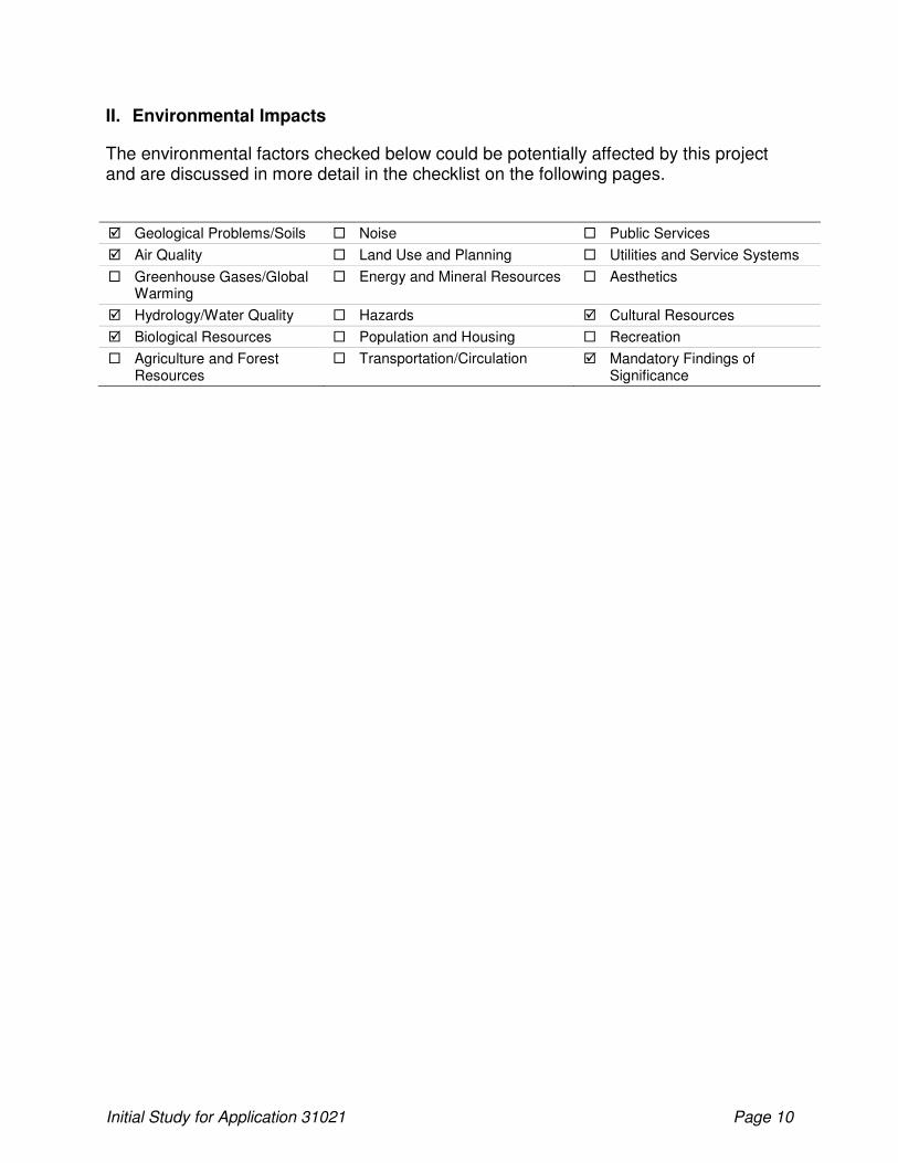
II. Environmental Impacts
The environmental factors checked below could be potentially affected by this project and are discussed in more detail in the checklist on the following pages.
� Geological Problems/Soils � Noise � Public Services
� Air Quality � Land Use and Planning � Utilities and Service Systems
� Greenhouse Gases/Global Warming
� Energy and Mineral Resources � Aesthetics
� Hydrology/Water Quality � Hazards � Cultural Resources
� Biological Resources � Population and Housing � Recreation
� Agriculture and Forest Resources
� Transportation/Circulation � Mandatory Findings of Significance
Initial Study for Application 31021 Page 11
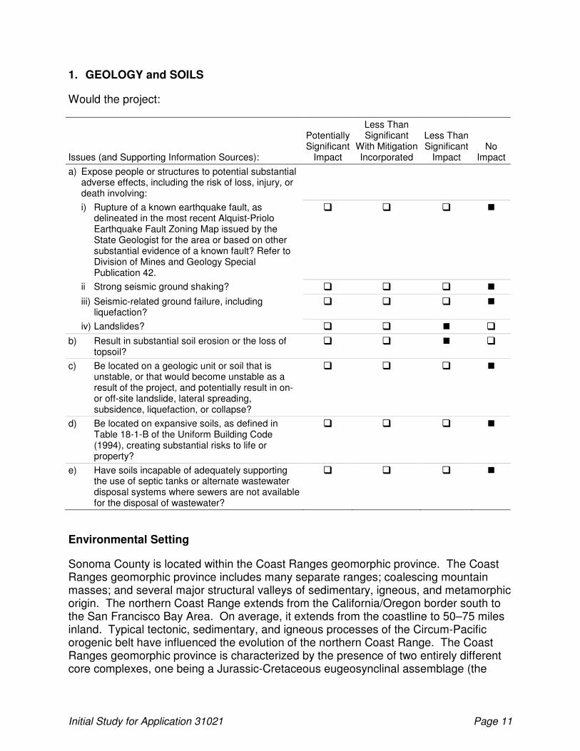
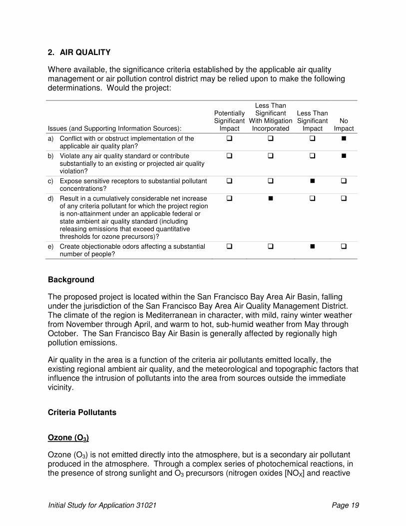
1. GEOLOGY and SOILS
Would the project:
Issues (and Supporting Information Sources):
Potentially Significant
Impact
Less Than Significant
With Mitigation Incorporated
Less Than Significant
Impact No
Impact
a) Expose people or structures to potential substantial adverse effects, including the risk of loss, injury, or death involving:
i) Rupture of a known earthquake fault, as delineated in the most recent Alquist-Priolo Earthquake Fault Zoning Map issued by the State Geologist for the area or based on other substantial evidence of a known fault? Refer to Division of Mines and Geology Special Publication 42.
� � � �
ii Strong seismic ground shaking? � � � �
iii) Seismic-related ground failure, including liquefaction?
� � � �
iv) Landslides? � � � �
b) Result in substantial soil erosion or the loss of topsoil?
� � � �
c) Be located on a geologic unit or soil that is unstable, or that would become unstable as a result of the project, and potentially result in on- or off-site landslide, lateral spreading, subsidence, liquefaction, or collapse?
� � � �
d) Be located on expansive soils, as defined in Table 18-1-B of the Uniform Building Code (1994), creating substantial risks to life or property?
� � � �
e) Have soils incapable of adequately supporting the use of septic tanks or alternate wastewater disposal systems where sewers are not available for the disposal of wastewater?
� � � �
Environmental Setting
Sonoma County is located within the Coast Ranges geomorphic province. The Coast Ranges geomorphic province includes many separate ranges; coalescing mountain masses; and several major structural valleys of sedimentary, igneous, and metamorphic origin. The northern Coast Range extends from the California/Oregon border south to the San Francisco Bay Area. On average, it extends from the coastline to 50–75 miles inland. Typical tectonic, sedimentary, and igneous processes of the Circum-Pacific orogenic belt have influenced the evolution of the northern Coast Range. The Coast Ranges geomorphic province is characterized by the presence of two entirely different core complexes, one being a Jurassic-Cretaceous eugeosynclinal assemblage (the
Initial Study for Application 31021 Page 12
Franciscan rocks) and the other consisting of early Cretaceous granitic intrusives and older metamorphic rocks. The two unrelated, incompatible core complexes lay side by side, separated from each other by faults. A large sequence of Cretaceous and Cenozoic clastic deposits covers large parts of the province. The rocks in the province are characterized by many folds, thrust faults, reverse faults, and strike-slip faults that have developed as a consequence of Cenozoic deformation. (Page 1966.)
The proposed project area is mapped by the California Geological Survey as being part of the Upper Petaluma Formation and Sonoma Volcanics (Wagner and Bortugno 1982; Wagner et al. 2002). There are also some Holocene alluvium deposits in the various drainages. Rocks of the Upper Petaluma Formation are mostly nonmarine sandstone, siltstone, and conglomerate. Rocks of the Sonoma Volcanics (for the specific geologic unit in the project area) are mostly andesite. Due to the low slopes in the proposed project area, these rock formations are expected to be stable.
Soils in the proposed project area are mapped by the Soil Conservation Service, now called the Natural Resources Conservation Service (NRCS) as Goulding cobbly clay loam, 5% to 15% slopes. Runoff is very rapid, and the erosion hazard is high. Soils are not expansive (Miller 1972).
Sonoma County faults are part of the San Andreas fault system that extends along the California coast. The last major earthquake in Sonoma County was a 5.7 magnitude event on the Healdsburg fault in Santa Rosa in 1969. Analysis of seismic data indicates that 7.5 to 8.5 magnitude earthquakes can be expected for the San Andreas and the Healdsburg-Rodgers Creek faults, respectively. Earthquakes of magnitude 8.0 or more on the San Andreas Fault can be expected every 50 to 200 years. (Sonoma County 2008.)
The proposed project area is not identified as being located in an Alquist-Priolo Earthquake Fault Zone (California Division of Mines and Geology 2001; California Geological Survey 2007a; Hart and Bryant 1997; International Conference of Building Officials 1997; Jennings and Bryant 2010; Sonoma County 2008; U.S. Geological Survey 2009). However, one active and several pre-Quaternary faults are located in an approximate 20-mile radius of the proposed project area. The Rodgers Creek fault zone and the Tolay fault are the closest faults/fault zones to the proposed project area. The Rodgers Creek fault is within an Alquist-Priolo Earthquake Fault Zone (California Division of Mines and Geology 2001).
Ground shaking from earthquakes can cause the most damage of any geologic hazard. The amount of ground shaking depends on the magnitude of the earthquake, the distance from the epicenter and the type of earth materials in between. Ground shaking similar to that which took place in Santa Rosa during the 1969 earthquake can be expected somewhere in Sonoma County once every 20 to 30 years (Sonoma County 2008).
Based on a probabilistic seismic hazard map that depicts the peak horizontal ground acceleration values exceeded at a 10% probability in 50 years (Cao et al. 2003;
Initial Study for Application 31021 Page 13
California Geological Survey 2007b), the probabilistic peak horizontal ground acceleration values for the proposed project area range from 0.4 to 0.6g, where one g equals the force of gravity. This indicates that the ground-shaking hazard in the project corridor is moderate.
Liquefaction is a phenomenon in which the strength and stiffness of unconsolidated sediments are reduced by earthquake shaking or other rapid loading. Poorly consolidated, water-saturated fine sands and silts having low plasticity and located within 50 feet of the ground surface are typically considered to be the most susceptible to liquefaction. Soils and sediments that are not water-saturated and that consist of coarser or finer materials are generally less susceptible to liquefaction (California Division of Mines and Geology 1997). Soils in the proposed project area are well above the water table and consist of clay loam and coarser cobbles. The liquefaction susceptibility in the proposed project area is very low (Wentworth et al. 2006).
According to the USGS, the proposed project area vicinity is mapped as having the potential for gravitational and seismically-induced landslides (Wentworth et al. 1997); however, because of the low slopes in the POU, landslide probability is low to uncertain.
In general, land uses vary in their sensitivity to geologic hazards. Agriculture (including vineyard operations) and timber management are considered appropriate in areas subject to geologic hazards because such uses require few occupied structures (Sonoma County 2008).
Findings
a i. Would the project expose people or structures to potential substantial adverse effects, including the risk of loss, injury, or death involving rupture of a known earthquake fault, as delineated in the most recent Alquist-Priolo Earthquake Fault Zoning Map issued by the State Geologist for the area or based on other substantial evidence of a known fault?
The proposed project area would not be subject to fault rupture because of its distance from active faults. Furthermore, no habitable structures were built or would be built as part of the proposed project, and the proposed project itself would not increase the present hazard of fault rupture. Accordingly, there is no impact.
a ii. Would the project expose people or structures to potential substantial adverse effects, including the risk of loss, injury, or death involving strong seismic ground shaking?
The probabilistic peak horizontal ground acceleration values for the proposed project area range from 0.4 to 0.6g, indicating that the ground-shaking hazard is moderate. However, no habitable structures were built or would be built as part of the proposed project, and the proposed project itself would not increase the present hazard of ground shaking. Accordingly, there is no impact.
Initial Study for Application 31021 Page 14
a iii. Would the project expose people or structures to potential substantial adverse effects, including the risk of loss, injury, or death involving seismic-related ground failure, including liquefaction?
Soils in the proposed project area are well above the water table and consist of loam and coarser substrate, thus rendering them not highly susceptible to liquefaction. Additionally, liquefaction susceptibility in the proposed project area is mapped as very low (Wentworth et al. 2006). Furthermore, no habitable structures were built or would be built as part of the proposed project. Accordingly, there is no impact.
a iv. Would the project expose people or structures to potential substantial adverse effects, including the risk of loss, injury, or death involving landslides?
No habitable structures were built or would be built as part of the proposed project. Because of the low slopes in the POU, landslide probability is low to uncertain. Accordingly, this impact is less than significant.
c. Would the project be located on a geologic unit or soil that is unstable, or that would become unstable as a result of the project, and potentially result in on- or off-site landslide, lateral spreading, subsidence, liquefaction, or collapse?
The majority of the project area is composed of the Upper Petaluma Formation and Sonoma Volcanics. There are also some Holocene alluvium deposits in the various drainages. These rock formations are expected to be locally stable. Accordingly, there is no impact associated with an unstable geologic unit.
d. Would the project be located on expansive soils, as defined in Table 18-1-B of the Uniform Building Code (1994), creating substantial risks to life or property?
The dominant soil map unit in the proposed project area is the Goulding cobbly clay loam, 5% to 15% slopes. Soils are not described as expansive (Miller 1972), due to their low clay content. Accordingly, there is no impact.
e. Would the project have soils incapable of adequately supporting the use of septic tanks or alternate wastewater disposal systems where sewers are not available for the disposal of wastewater?
No septic tanks or wastewater disposal systems were or are proposed as part of the project. Accordingly, there is no impact associated with soils incapable of adequately supporting the use of septic tanks or alternate wastewater disposal systems where sewers are not available for the disposal of wastewater.
Initial Study for Application 31021 Page 15
Soil Erosion Impact Discussion and Findings (Impact b)
b. Would the project result in substantial soil erosion or the loss of topsoil?
Two impact analyses are discussed herein: (1) the potential for soil erosion during the development of 50 acres of vineyard in 2005; and (2) the potential for soil erosion during the pending development of the remainder of the POU.
Past Vineyard Development Impacts
Fifty acres were planted the western portion of the project area between June and July, 2005 in accordance with a Sonoma County grading permit and a Sonoma County VESCO application and permit (Figure 2).
Development of the 50 acres to vineyard (including the installation of the irrigation system) required temporary soil disturbance. The potential existed for the mobilization of sediment during construction and after construction from unstabilized areas. However, compliance with the Sonoma County VESCO (Sonoma County Code, Chapter 30, Article V, Ord. No. 5216 § 2, 2000) permit requirements presumably ensured that no geologic or soil resources on the 50-acre parcel were significantly affected.
The Sonoma County Permit and Resource Management Department (PRMD) requires grading permits for projects that involve more than 50 cubic yards of fill on any lot or projects that include an excavation or fill that alters or obstructs a drainage course. Additionally, the Sonoma County Agricultural Commission’s Agricultural Division administers the Sonoma County VESCO.
The purpose of the ordinance is to safeguard public health, safety, and welfare; minimize erosion and sedimentation in connection with vineyard planting and replanting in the county; protect the lands, streams, and riparian habitat in the county; and ensure the long-term economic viability of the county’s viticulture resources.
Growers planting new vineyards or replanting existing vineyards are required to use recognized conservation practices and best management practices (BMPs), and provide for riparian setbacks to protect the environment and watersheds of the county.
The vineyard development included Level II plantings. The ordinance defines them as:
• Level II vineyard planting means any vineyard planting on contiguous new vineyard land under common ownership with a significant drainage area that has similar slope characteristics and has either highly erodible soils and an average slope of ten percent to not more than 15 percent, or less erodible soils and an average slope of 15 percent to not more than 30 percent.
Initial Study for Application 31021 Page 16
General requirements for authorized vineyard plantings include:
• Any person undertaking a Level II or III vineyard planting shall obtain a certified erosion and sediment control plan for the vineyard planting, notify the agricultural commission of the vineyard planting and request that the agricultural commissioner review the vineyard planting and the certified erosion and sediment control plan for the vineyard planting as required under the Ordinance, and undertake the vineyard planting in accordance with the requirements of the Ordinance and the certified erosion and sediment control plan for the vineyard planting. The vineyard planting shall establish and maintain a riparian setback for any designated stream on the vineyard site of either fifty feet from the top of the bank, or, if applicable, the distance specified in the Riparian Corridors section (26-66-030), whichever is greater.
In brief, the Applicant conducted the following steps to prevent soil erosion or slope failure on the 50-acre parcel.
• Prior to the start of construction or diversion or use of water, the Applicant filed a notice of vineyard planting with the Sonoma County agricultural commissioner. The notice conformed to applicable provisions of the Sonoma County Vineyard Erosion and Sediment Control Ordinance (Ord. No. 5216 §§ 2, 2000). The notice included:
1) maps, plans, drawings, calculations, photographs, and other information as was necessary or required by the agricultural commissioner to verify that the vineyard planting qualifies as a Level II authorized vineyard planting; and
2) an erosion and sediment control plan, certified pursuant to Section 30-74 of the Sonoma County VESCO, for the vineyard planting.
The Applicant will provide the following prior to the issuance of a water right permit.
• Prior to the diversion or use of water under this permit, permittee shall submit evidence to the Deputy Director for Water Rights verifying that the Sonoma County agricultural commissioner had previously authorized the 50-acre vineyard planting 2005.
• Prior to diversion or use of water under this permit, permittee shall submit copies of obtained grading permits from Sonoma County to the Deputy Director for Water Rights.
• Prior to licensing of this permit, permittee shall submit evidence to the Deputy Director for Water Rights verifying that the project was constructed in compliance with the requirements of the certified erosion and sediment control plan and the Sonoma County VESCO.
In brief, compliance with the measures incorporated within an erosion and sedimentation control plan as required by Sonoma County and compliance with conditions of the Sonoma County grading permit and the requirements of the Sonoma
Initial Study for Application 31021 Page 17
County VESCO reduced potential soil erosion impacts associated with the 50-acre parcel to a less-than-significant level5.
Future Vineyard Development Impacts
Construction of the proposed reservoir and additional vineyard, including construction of underground pipelines routed from the POD to the POU, would require temporary soil disturbance. The potential exists for the mobilization of sediment during construction and after construction from unstabilized areas. However, compliance with the Sonoma County Vineyard Erosion and Sediment Control Ordinance (Sonoma County Code, Chapter 30, Article V, Ord. No. 5216 § 2, 2000) permit requirements would ensure that no geologic or soil resources are significantly impacted by the proposed project.
The Sonoma County Permit Resource Management Department requires grading permits for projects that involve more than 50 cubic yards of fill on any lot or projects that include an excavation or fill that alters or obstructs a drainage course. Additionally, the Sonoma County Agricultural Commission’s Agricultural Division administers the Sonoma County Vineyard Erosion and Sediment Control Ordinance that was passed by the Board of Supervisors on February 8, 2000.
The following permit terms, substantially as follows, shall be included in any water right permit or license issued pursuant to Application 31021 to prevent soil erosion or slope failure:
• Prior to the start of construction or diversion or use of water under this permit, permittee shall file a notice of vineyard planting or replanting with the Sonoma County agricultural commissioner. The notice shall conform to applicable provisions of the Sonoma County Vineyard Erosion and Sediment Control Ordinance (Ord. No. 5216 §§ 2, 2000). The notice shall include:
1) maps, plans, drawings, calculations, photographs, and other information as may be necessary or required by the agricultural commissioner to verify that the vineyard planting qualifies as a Level II or III authorized vineyard planting, or that the vineyard replanting qualifies as a Level II authorized vineyard replanting; and
2) an erosion and sediment control plan, certified pursuant to Section 30-74 of the Sonoma County Vineyard Erosion and Sediment Control Ordinance, for the vineyard planting or replanting.
• Prior to the start of construction or diversion or use of water under this permit, permittee shall submit evidence to the Deputy Director for Water Rights verifying that the Sonoma County agricultural commissioner has authorized the vineyard planting or replanting to proceed.
5 Site inspections conducted by the Sonoma County PRMD during and after the vineyard development indicated no violations and more than adequate short- and long-term BMP implementation.
Initial Study for Application 31021 Page 18
• Prior to construction, diversion, or use of water under this permit permittee shall obtain any required grading permits from Sonoma County and submit copies to the Deputy Director for Water Rights.
• Prior to licensing of this permit, permittee shall submit evidence to the Deputy Director for Water Rights verifying that the project was constructed in compliance with the requirements of the certified erosion and sediment control plan and the Sonoma County Vineyard Erosion and Sediment Control Ordinance.
Compliance with the measures incorporated within an Erosion and Sedimentation Control Plan as required by Sonoma County and compliance with conditions of the Sonoma County Grading Permit and the requirements of the Sonoma County Vineyard and Sediment Control Ordinance would reduce potential impacts to a less-than-significant level.
Initial Study for Application 31021 Page 19
2. AIR QUALITY
Where available, the significance criteria established by the applicable air quality management or air pollution control district may be relied upon to make the following determinations. Would the project:
Issues (and Supporting Information Sources):
Potentially Significant
Impact
Less Than Significant
With Mitigation Incorporated
Less Than Significant
Impact No
Impact
a) Conflict with or obstruct implementation of the applicable air quality plan?
� � � �
b) Violate any air quality standard or contribute substantially to an existing or projected air quality violation?
� � � �
c) Expose sensitive receptors to substantial pollutant concentrations?
� � � �
d) Result in a cumulatively considerable net increase of any criteria pollutant for which the project region is non-attainment under an applicable federal or state ambient air quality standard (including releasing emissions that exceed quantitative thresholds for ozone precursors)?
� � � �
e) Create objectionable odors affecting a substantial number of people?
� � � �
Background
The proposed project is located within the San Francisco Bay Area Air Basin, falling under the jurisdiction of the San Francisco Bay Area Air Quality Management District. The climate of the region is Mediterranean in character, with mild, rainy winter weather from November through April, and warm to hot, sub-humid weather from May through October. The San Francisco Bay Air Basin is generally affected by regionally high pollution emissions.
Air quality in the area is a function of the criteria air pollutants emitted locally, the existing regional ambient air quality, and the meteorological and topographic factors that influence the intrusion of pollutants into the area from sources outside the immediate vicinity.
Criteria Pollutants
Ozone (O3)
Ozone (O3) is not emitted directly into the atmosphere, but is a secondary air pollutant produced in the atmosphere. Through a complex series of photochemical reactions, in the presence of strong sunlight and O3 precursors (nitrogen oxides [NOX] and reactive
Initial Study for Application 31021 Page 20
organic gases [ROG]), O3 is created. Motor vehicles are a major source of O3 precursors. O3 causes eye and respiratory irritation, reduces resistance to lung infection, and may aggravate pulmonary conditions in persons with lung disease.
Carbon Monoxide (CO)
CO is an odorless, invisible gas usually formed as the result of incomplete combustion of organic substances and is primarily a winter pollution problem. CO concentrations are influenced by the spatial and temporal distributions of vehicular traffic, wind speed, and atmospheric mixing. High levels of CO can impair the transport of oxygen in the bloodstream, thereby aggravating cardiovascular disease and causing fatigue, headaches, and dizziness.
Respirable Particulate Matter (PM10)
PM10 consists of particulate matter ten microns (one micron is one one-millionth of a meter) or less in diameter, which can be inhaled. Relatively small particles of certain substances (e.g., sulfates and nitrates) can cause lung damage directly, or can contain adsorbed gases (e.g., chlorine or ammonia) that may be injurious to health. Primary sources of PM10 emissions in Sonoma County are entrained road dust and construction and demolition activities. Burning of wood in residential wood stoves and fireplaces and open agricultural burning are other sources of PM10. The amount of particulate matter and PM10 generated is dependent on the soil type and the soil moisture content.
Regulatory Setting
Regulation of air quality is achieved through both federal and state ambient air quality standards and emission limits for individual sources of air pollutants.
Federal
The 1977 Federal Clean Air Act (CAA) required the United States Environmental Protection Agency (EPA) to identify National Ambient Air Quality Standards (NAAQS) to protect public health and welfare. NAAQS have been established for the six “criteria” air pollutants, O3, CO, NOX, sulfur dioxide (SOX), PM10, and lead. The EPA publishes standards for these pollutants, listed in Table 3.
Pursuant to the 1990 CAA Amendments, the EPA has classified air basins (or portions thereof) as either “attainment” or “non-attainment” for each criteria air pollutant, based on whether or not the NAAQS have been achieved. Southern Sonoma County, located in the San Francisco Bay Area Air Basin, is designated as nonattainment for O3 and either attainment or unclassified for CO, NOX, SOX, and PM10 (California Air Resources Board 2008a).

Initial Study for Application 31021 Page 21
Table 3. State and National Ambient Air Quality Standards
Pollutant Averaging Time SAAQS NAAQS
Ozone 1 hour 0.09 ppm 0.12 ppm
Carbon Monoxide 1 hour
8 hour
20 ppm
9.0 ppm
35 ppm
9.0 ppm
Nitrogen Dioxide 1 hour
Annual
0.25 ppm
N/A
N/A
0.053 ppm
Sulfur Dioxide 1 hour
3 hour
24 hour
Annual
0.25 ppm
N/A
0.04 ppm
N/A
N/A
0.5 ppm
0.14 ppm
0.03 ppm
Respirable Particulate Matter 24 hour
Annual
50 µg/m3
20 µg/m3
150 µg/m3
50 µg/m3
Lead 30 day
Calendar Quarter
1.5 µg/m3
N/A
N/A
1.5 µg/m3
Notes:
SAAQS (i.e., California standards) for ozone, carbon monoxide, sulfur dioxide (1-hour and 24-hour), nitrogen dioxide, and respirable particulate matter are values that are not to be exceeded. All other California standards shown are values not to be equaled or exceeded.
NAAQS (i.e., national standards), other than ozone, particulate matter and those based on annual averages, are not to be exceeded more than once a year. The ozone standard is attained when the fourth highest eight-hour concentration in a year, averaged over three years, is equal to or less than the standard.
ppm = parts per million by volume; µg/m3 = micrograms per cubic meter of air; N/A: Not Applicable.
Source: California Air Resources Board 2008b.
State
The California Air Resources Board regulates mobile emissions sources and oversees the activities of county Air Pollution Control Districts and regional Air Quality Management Districts. The California Air Resources Board regulates local air quality indirectly by State Ambient Air Quality Standards (SAAQS) and vehicle emission standards by conducting research activities, and through planning and coordinating activities.
California has adopted ambient standards that are more stringent than the federal standards for the criteria air pollutants. These standards are shown in Table 3. Under the California Clean Air Act, patterned after the Federal CAA, areas have been designated as attainment or nonattainment with respect to SAAQS. The San Francisco Bay Area Air Basin is designated as nonattainment for PM10 and O3, attainment for CO, and attainment or unclassified for NOX, SOX, and lead (California Air Resources Board 2008b).

Initial Study for Application 31021 Page 22
Existing Air Quality Conditions
The California Air Resources Board maintains several ambient air quality monitoring stations within the San Francisco Bay Area Air Quality Management District that provide information on the average concentrations of criteria air pollutants in the region. The Santa Rosa—5th Street monitoring station is located in closest proximity to the project area. However, it should be noted that the monitoring station is located in an urban area while the proposed project area is located in a rural area. Table 4 summarizes ambient air quality monitoring data from this location and compares ambient air pollutant concentrations of O3, CO, and PM10 to SAAQS and NAAQS.
Table 4. Ambient Air Quality Monitoring Data
Pollutant 1999 2000 2001 2002
Ozone (O3)
Maximum 1-hour concentration (ppm) 0.095 0.078 0.086 0.077
Number of days Standard exceeded
SAAQS (1-hour) > 0.09 ppm 1 0 0 0
NAAQS (1-hour) > 0.12 ppm 0 0 0 0
Carbon Monoxide (CO)
Maximum 8-hour concentration (ppm) 3.44 3.05 2.40 2.10
Number of days Standard exceeded
SAAQS (8-hour) ≥ 9.0 ppm 0 0 0 0
NAAQS (8-hour) ≥ 9.0 ppm 0 0 0 0
Particulate Matter (PM10)
Maximum 24-hour concentration (µg/m3) 54 46 74 60
Number of days Standard exceeded
SAAQS (24-hour) > 50 µg/m3 0 0 12 12
NAAQS (24-hour) > 150 µg/m3 0 0 0 0
Notes:
Data is from the Santa Rosa–5th Street monitoring station
ppm = parts per million; µg/m3 = micrograms per cubic meter
Source: California Air Resources Board 2008c.
Findings
The San Francisco Bay Area Air Quality Management District has prepared guidelines for assessing the air quality impacts of proposed projects (Bay Area Air Quality Management District 1999). The San Francisco Bay Area Air Quality Management District approach to assessment of construction-related air quality impacts is to emphasize the implementation of effective and comprehensive control measures rather than provide detailed quantification of emissions (Bay Area Air Quality Management District 1999).
Initial Study for Application 31021 Page 23
a. Would the project conflict with or obstruct implementation of the applicable air quality plan?
The project did not nor would not conflict with or obstruct implementation of the applicable air quality plan. As such, there is no impact.
b. Would the project violate any air quality standard or contribute substantially to an existing or projected air quality violation?
The project did not nor would not violate any air quality standard or contribute substantially to an existing or projected air quality violation. As such, there is no impact.
c. Would the project expose sensitive receptors to substantial pollutant concentrations?
Routine continued compliance with permit regulations from the Sonoma County Agricultural Commissioner’s Office for the use of soil stabilizers, pesticides, herbicides, and other regulated chemicals continues to render exposure of sensitive receptors to pollutants a less-than-significant impact and will render exposure of sensitive receptors to pollutants a less-than-significant impact.
d. Would the project result in a cumulatively considerable net increase of any criteria pollutant for which the project region is non-attainment under an applicable federal or state ambient air quality standard (including releasing emissions that exceed quantitative thresholds for ozone precursors)?
Air quality impacts associated with the development of 50 acres of vineyard in 2005 were limited to those resulting from short-term construction activities. Construction-related emissions most likely included exhaust from construction equipment and fugitive dust from trenching during the installation of the irrigation system, movement of vehicles, and wind erosion of exposed soil during vineyard installation. However, as the proposed project area had historically operated as a ranch, few additional workers or vehicles (which are the primary sources of operational greenhouse gas [GHG] emissions) were required. Furthermore, the Applicant minimized dust exposure on a regular basis through watering efforts. As such, impacts on air quality associated with the development of 50 acres of vineyard in 2005 were less than significant.
Potentially significant air quality impacts associated with the development of the remainder of the POU are limited to those resulting from short-term construction activities. Construction-related emissions could include exhaust from construction equipment and fugitive dust from land clearing, earthmoving, movement of vehicles, and wind erosion of exposed soil during reservoir construction or development of the proposed vineyard. In order to minimize potential air quality impacts a dust control plan will be developed and implemented for the proposed project. At a minimum, the plan should include, but not be limited to the following measures:
Initial Study for Application 31021 Page 24
1. Active construction areas shall be watered at least twice daily; all trucks hauling soil, sand, or other loose material shall be covered or required to maintain at least two feet of freeboard (i.e., the minimum required space between the top of the load and the top of the trailer);
2. Exposed stockpiles shall be covered or watered twice daily;
3. All construction vehicles and equipment shall be properly maintained and operated, and the use of construction equipment that meets the current emission standards for diesel engine-powered equipment shall be required; and
4. Traffic speeds on unpaved access roads shall be limited to 15 miles per hour.
To protect air quality, a permit term, substantially as follows, will be included in any water right permit or license issued pursuant to Application 31021:
• Prior to the start of construction permittee shall submit a detailed Emission Control and Mitigation Plan to the Deputy Director for Water Rights. Permittee shall also submit a copy of the plan to the San Francisco Bay Area Air Quality Management District. The Emission Control and Mitigation Plan shall be consistent with the San Francisco Bay Area Air Quality Management District’s Air Quality Guidelines and include a monitoring and reporting component to ensure that mitigation measures identified in the Emission Control and Mitigation Plan are implemented. Permittee shall provide evidence to verify implementation of measures identified in the Emission Control and Mitigation Plan within 30 days of completion of construction work to the Deputy Director for Water Rights. Permittee shall also provide a copy of the evidence to the San Francisco Bay Area Air Quality Management District upon request. Evidence may consist of, but is not limited to, photographs and construction records.
Implementation of the above permit term would reduce potential impacts to a less-than-significant level.
e. Would the project create objectionable odors affecting a substantial number of people?
Application of agricultural chemicals during vineyard operation continues to have the potential to result in objectionable odors. Continued compliance with requirements of the Sonoma County Agricultural Commissioner continues to minimize nuisance odors to a less-than-significant level and will minimize nuisance odors to a less-than-significant level.3.
Initial Study for Application 31021 Page 25
3. GREENHOUSE GASES/GLOBAL WARMING
Would the project:
Issues (and Supporting Information Sources):
Potentially Significant
Impact
Less than Significant
with Mitigation Incorporated
Less-than-Significant
Impact No
Impact
a) Generate greenhouse gas emission, either directly or indirectly, that may have a significant impact on the environment, based on any applicable threshold of significance?
� � � �
b) Conflict with any applicable plan, policy or regulation of an agency adopted for the purpose of reducing the emissions of greenhouse gases?
� � � �
Environmental Setting
On September 27, 2006, the State of California adopted Assembly Bill 32 (California Global Warming Solutions Act of 2006). The bill requires the State Air Resources Board to adopt a statewide GHG emissions limit equivalent to the statewide GHG emissions levels in 1990 to be achieved by 2020. GHGs include carbon dioxide, methane, nitrous oxide, hydrofluorocarbons, perfluorocarbons, and sulfur hexafluoride. The State of California Air Resources Board approved 427 million metric tons of carbon dioxide equivalents (MMTCO2e) as the statewide GHG emission limit, which is equivalent to the 1990 emissions level. Carbon dioxide equivalent means the amount of carbon dioxide by weight that would produce the same climate change impact as a given weight of another GHG. Northern Sonoma County does not exceed the federal 8-hour ozone standard.
GHGs, including carbon dioxide, methane, and nitrous oxide, serve to regulate the earth’s surface temperature, keeping the earth’s average temperature close to 60° Fahrenheit (F). GHGs occur both naturally and as a result of human-made activities (anthropogenic sources).
Climate change refers to any significant change in measures of climate (such as temperature, precipitation, or wind) lasting for an extended period (decades or longer). Over the past 200 years, anthropogenic sources, including the burning of fossil fuels (such as coal and oil) and deforestation, have caused the concentrations of heat-trapping GHGs to increase significantly in the atmosphere (U.S. Environmental Protection Agency 2008a).
In the U.S., energy-related activities account for three quarters of human-generated GHG emissions, mostly in the form of carbon dioxide emissions from burning fossil fuels. More than half the energy-related emissions come from large stationary sources such as power plants, while about a third comes from transportation. Industrial processes (such as the production of cement, steel, and aluminum), agriculture,
Initial Study for Application 31021 Page 26
forestry, other land use, and waste management are also important sources of GHG emissions in the United States. (U.S. Environmental Protection Agency 2008b.)
If GHGs continue to increase, climate models predict that the average temperature at the earth's surface could increase from 2.5 to 10.4ºF above 1990 levels by the end of this century. Scientists are certain that human activities are changing the composition of the atmosphere, and that increasing the concentration of GHGs will change the planet's climate. (U.S. Environmental Protection Agency 2008b.)
Rising average temperatures already are affecting the environment. In California during the last 50 years, winter and spring temperatures have been warmer, spring snow levels in lower and mid-elevation mountains have dropped, and snowpack has been melting 1 to 4 weeks earlier. Climate change projections through 2100 indicate an increase in the number of severe heat days, an increase in poor air quality days, and a declining Sierra snowpack. Such changes could adversely affect health, water supplies, hydropower, agriculture, and recreation in California. (California Climate Change Center 2009.)
Regulatory Setting
The State of California has enacted legislative measures to implement policies and regulatory actions to quantify and reduce GHGs. The most prominent of these is AB 32, Nunez (2006)—the California Global Warming Solutions Act of 2006. AB 32 declares that global warming is a serious threat to the public health, economic well-being, natural resources, and environment of California. AB 32 makes the California Air Resources Board responsible for monitoring and reducing GHG emissions and requires it to:
1. Establish (by January 1, 2008) a statewide GHG emissions cap for 2020, based on 1990 emissions.
2. Adopt a plan by January 1, 2009 showing how emissions reductions will be achieved from significant GHG sources via regulations, market mechanisms, and other actions.
3. Adopt a list of discrete early action measures by July 1, 2007, that can be implemented before January 1, 2010, and beyond. The Early Action List required by the California Global Warming Solutions Act of 2006 contains nine discrete early action items. These actions are primarily transportation-related, with commercial actions included as well. They are intended to target the most significant sources of GHGs.
On April 13, 2009, the Governor’s Office of Planning and Research submitted to the Secretary for Natural Resources its proposed GHG emission amendments to the State CEQA Guidelines, as required by SB 97 (Chapter 185, 2007). Those amendments were adopted on December 30, 2009. The amendments set target GHG emission reductions for all metropolitan planning organizations (MPO). Each MPO must design a Sustainable Communities Strategy or alternative strategy as part of its regional transportation plan to achieve 2020 and 2035 GHG emission targets set by the Air Resources Board for each region. Local agencies not included within an MPO are
Initial Study for Application 31021 Page 27
exempt from the GHG emission targets, but they must address the State CEQA Guidelines requirement contained in the Initial Study checklist for projects that they are considering.
The local agency with jurisdiction over air quality and GHG regulations is the Bay Area Air Quality Management District, which recently adopted6 the approach to the determination of significance of GHG emissions based on the GHG significance threshold of 1,100 metric tons CO2 per year for projects that are not stationary sources. However, as stated on their website, it is the Bay Area Air Quality Management District’s policy that the adopted thresholds apply to projects for which environmental analysis begins on or after the applicable effective date. As discussed above in the Project Background and California Environmental Quality Act Baseline Conditions section, February 29, 2000, is considered the CEQA baseline date and the date that environmental review for the proposed project began. Accordingly, the proposed project is not subject to the thresholds identified in the recently adopted 2010 Bay Area Air Quality Management District CEQA guidelines.
Findings
a. Would the project generate greenhouse gas emission, either directly or indirectly, that may have a significant impact on the environment, based on any applicable threshold of significance?
The development of approximately 50 acres of vineyard in 2005 included operational sources of GHG emissions including vehicle travel and energy use, and water transport. However, based on the project activities (primarily vehicular traffic and trenching for the irrigation system), operational sources of GHG emission were minimal and typical of normal vineyard operations7. Increases in energy use and water transport were minimal as there is little electricity used onsite and water sources are close in proximity.
The pending development of 254 acres of vineyard will include operational sources of GHG emissions such as vehicle travel, energy use, and water transport. However, as a portion of the proposed project area currently operates as a vineyard, a significant addition of workers or vehicles (which are the primary sources of operational GHG emissions) will not be required. Increases in energy use and water transport are anticipated to be minimal as there is little electricity used on site and water sources are located nearby.
6 The Bay Area Air Quality Management District CEQA guidelines were adopted on June 2, 2010, and were effective as of the adoption date.
7 The Bay Area Air Quality Management District’s GHG significance threshold of 1,100 metric tons CO2 per year for projects that are not stationary sources was surely not exceeded.
Initial Study for Application 31021 Page 28
This impact is considered less than significant.
b. Would the project conflict with any applicable plan, policy or regulation of an agency adopted for the purpose of reducing the emissions of greenhouse gases?
The proposed project did not and would not conflict with an applicable plan, policy, or regulation adopted for the purpose of reducing GHG emissions. Accordingly, there is no impact.
Initial Study for Application 31021 Page 29
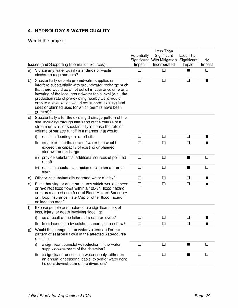
4. HYDROLOGY & WATER QUALITY
Would the project:
Issues (and Supporting Information Sources):
Potentially Significant
Impact
Less Than Significant
With Mitigation Incorporated
Less Than Significant
Impact No
Impact
a) Violate any water quality standards or waste discharge requirements?
� � � �
b) Substantially deplete groundwater supplies or interfere substantially with groundwater recharge such that there would be a net deficit in aquifer volume or a lowering of the local groundwater table level (e.g., the production rate of pre-existing nearby wells would drop to a level which would not support existing land uses or planned uses for which permits have been granted)?
� � � �
c) Substantially alter the existing drainage pattern of the site, including through alteration of the course of a stream or river, or substantially increase the rate or volume of surface runoff in a manner that would:
i) result in flooding on- or off-site � � � �
ii) create or contribute runoff water that would exceed the capacity of existing or planned stormwater discharge
� � � �
iii) provide substantial additional sources of polluted runoff
� � � �
iv) result in substantial erosion or siltation on- or off-site?
� � � �
d) Otherwise substantially degrade water quality? � � � �
e) Place housing or other structures which would impede or re-direct flood flows within a 100-yr. flood hazard area as mapped on a federal Flood Hazard Boundary or Flood Insurance Rate Map or other flood hazard delineation map?
� � � �
f) Expose people or structures to a significant risk of loss, injury, or death involving flooding:
i) as a result of the failure of a dam or levee? � � � �
ii) from inundation by seiche, tsunami, or mudflow? � � � �
g) Would the change in the water volume and/or the pattern of seasonal flows in the affected watercourse result in:
i) a significant cumulative reduction in the water supply downstream of the diversion?
� � � �
ii) a significant reduction in water supply, either on an annual or seasonal basis, to senior water right holders downstream of the diversion?
� � � �
Initial Study for Application 31021 Page 30
Issues (and Supporting Information Sources):
Potentially Significant
Impact
Less Than Significant
With Mitigation Incorporated
Less Than Significant
Impact No
Impact
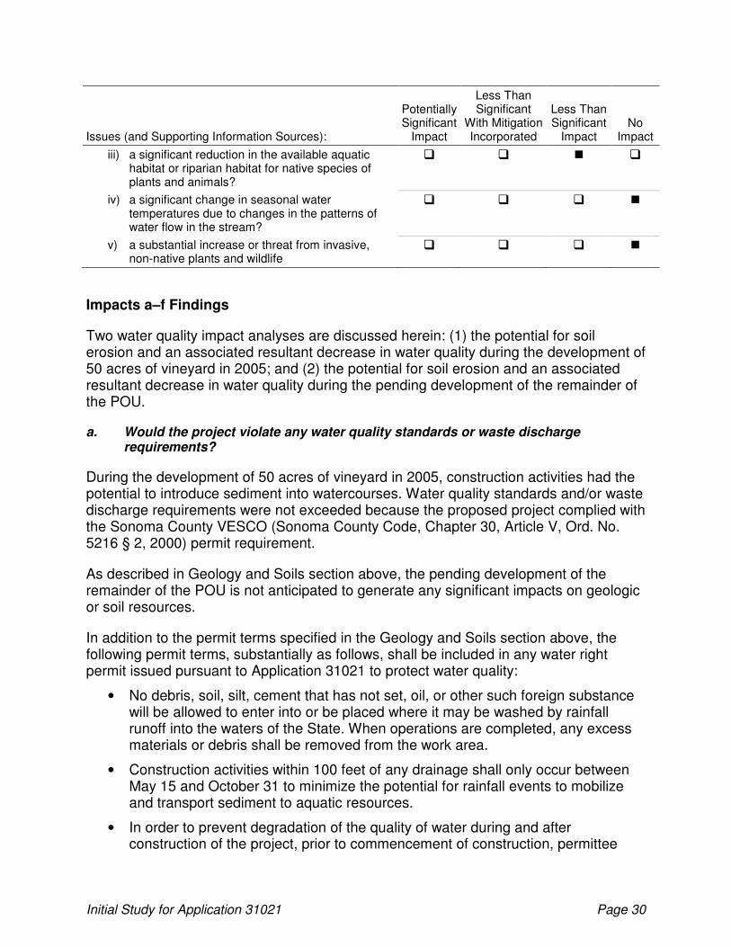
iii) a significant reduction in the available aquatic habitat or riparian habitat for native species of plants and animals?
� � � �
iv) a significant change in seasonal water temperatures due to changes in the patterns of water flow in the stream?
� � � �
v) a substantial increase or threat from invasive, non-native plants and wildlife
� � � �
Impacts a–f Findings
Two water quality impact analyses are discussed herein: (1) the potential for soil erosion and an associated resultant decrease in water quality during the development of 50 acres of vineyard in 2005; and (2) the potential for soil erosion and an associated resultant decrease in water quality during the pending development of the remainder of the POU.
a. Would the project violate any water quality standards or waste discharge requirements?
During the development of 50 acres of vineyard in 2005, construction activities had the potential to introduce sediment into watercourses. Water quality standards and/or waste discharge requirements were not exceeded because the proposed project complied with the Sonoma County VESCO (Sonoma County Code, Chapter 30, Article V, Ord. No. 5216 § 2, 2000) permit requirement.
As described in Geology and Soils section above, the pending development of the remainder of the POU is not anticipated to generate any significant impacts on geologic or soil resources.
In addition to the permit terms specified in the Geology and Soils section above, the following permit terms, substantially as follows, shall be included in any water right permit issued pursuant to Application 31021 to protect water quality:
• No debris, soil, silt, cement that has not set, oil, or other such foreign substance will be allowed to enter into or be placed where it may be washed by rainfall runoff into the waters of the State. When operations are completed, any excess materials or debris shall be removed from the work area.
• Construction activities within 100 feet of any drainage shall only occur between May 15 and October 31 to minimize the potential for rainfall events to mobilize and transport sediment to aquatic resources.
• In order to prevent degradation of the quality of water during and after construction of the project, prior to commencement of construction, permittee

Initial Study for Application 31021 Page 31
shall file a report pursuant to Water Code Section 13260 and shall comply with all waste discharge requirements imposed by the California Regional Water Quality Control Board, San Francisco Bay Region, or by the State Water Resources Control Board.
Compliance with the permit terms above would reduce potential water quality impacts to a less than significant level.
b. Would the project substantially deplete groundwater supplies or interfere substantially with groundwater recharge such that there would be a net deficit in aquifer volume or a lowering of the local groundwater table level (e.g., the production rate of pre-existing nearby wells would drop to a level which would not support existing land uses or planned uses for which permits have been granted)?
The proposed project did not or will not substantially deplete groundwater supplies or interfere substantially with groundwater recharge such that there would be a net deficit in aquifer volume or a lowering of the local groundwater table level. The existing vineyard is and the remaining vineyard will be 100% irrigated with reservoir water. There is only one well on the entire proposed project area and this is used to supply domestic water for the two residences.
c. Would the project substantially alter the existing drainage pattern of the site, including through alteration of the course of a stream or river, or substantially increase the rate or volume of surface runoff in a manner that would: i) result in flooding on- or off-site; ii) create or contribute runoff water that would exceed the capacity of existing or planned stormwater discharge; iii) provide substantial additional sources of polluted runoff; or iv) result in substantial erosion or siltation on- or off-site?
During the development of 50 acres of vineyard in 2005, no topography modifications were necessary—as such, existing drainage patterns were maintained. Water quality objectives were met with appropriate erosion controls, and the vineyard development did not alter the overall drainage pattern of the area. No substantial additional sources of polluted runoff were generated. As such, there is no impact associated with the prior development of 50 acres of vineyard in 2005.
The proposed diversion and construction of the offstream reservoir would not alter the course of the Unnamed Stream from which the diversion would occur. Existing drainage patterns need to be and should be maintained. Since no topography modifications are proposed with vineyard installation, drainage patterns will not change. Water quality objectives can be met with appropriate erosion controls and vegetation within tributary areas converted to vineyard. The proposed project would not alter the overall drainage pattern of the area. No substantial additional sources of polluted runoff are expected. As such, there is no impact.
d. Would the project otherwise substantially degrade water quality?
The proposed project did not or will not otherwise substantially degrade water quality. Accordingly there is no impact.
Initial Study for Application 31021 Page 32
e. Would the project place housing or other structures which would impede or re-direct flood flows within a 100-yr. flood hazard area as mapped on a federal Flood Hazard Boundary or Flood Insurance Rate Map or other flood hazard delineation map?
The proposed project did not or will not place housing or other structures which would impede or re-direct flood flows within a 100-year flood hazard area as mapped on a federal Flood Hazard Boundary or Flood Insurance Rate Map or other flood hazard delineation map. As such, there is no impact.
f. Would the project expose people or structures to a significant risk of loss, injury, or death involving flooding: i) as a result of the failure of a dam or levee?; or ii) from inundation by seiche, tsunami, or mudflow?
The proposed project did not or will not expose people or structures to a significant risk of loss, injury, or death involving flooding as a result of the failure of a dam or levee or from inundation by seiche, tsunami, or mudflow. As such, there is no impact.
California Department of Fish and Game and National Marine Fisheries Service Draft Guidelines
In 2002, DFG and NMFS developed Draft Guidelines for Maintaining Instream Flows to Protect Fisheries Resources Downstream of Water Diversions in Mid-California Coastal Streams (DFG-NMFS Draft Guidelines) (California Department of Fish and Game and the National Marine Fisheries Service 2002). The DFG-NMFS Draft Guidelines were recommended for use by permitting agencies (including the Division), planning agencies, and water resources development interests when evaluating proposals to divert and use water from northern California coastal streams. The DFG-NMFS Draft Guidelines apply to projects located in the geographic area of Sonoma, Napa, Mendocino, and Marin counties, and portions of Humboldt County. The proposed project is within the geographic limits of the DFG-NMFS Draft Guidelines.
The DFG-NMFS Draft Guidelines recommend that terms and conditions be included in new water right permits for small diversions to protect fishery resources in the absence of site-specific biologic and hydrologic assessments. The DFG-NMFS Draft Guidelines recommend limiting new water right permits to diversions during the winter period (December 15 through March 31) when stream flows are generally high. The project’s proposed diversion season is within the season recommended by the DFG-NMFS Draft Guidelines.
The DFG-NMFS Draft Guidelines provide a process for assessing the cumulative impacts of multiple diversion projects on downstream fisheries habitat by calculating the CFII to estimate the cumulative effects of existing and pending projects in a watershed of interest. The DFG-NMFS Draft Guidelines recommend a bypass flow that adequately protects salmonids and aquatic resources downstream from the POD. Specifically, a bypass not less than the February Median Flow (FMF) at the POD is recommended absent a site-specific study to determine a protective bypass flow.

Initial Study for Application 31021 Page 33
Before the Division can issue a water right permit, it must find that there is unappropriated water available to supply the applicant. In determining the amount of water available for diversion, the Division must take into account, whenever it is in the public interest, the amount of water required to maintain instream beneficial uses such as fish and wildlife resources. An assessment of the project’s potential impacts to instream biological resources is provided in Section 4, Biological Resources.
Impact g Findings
g i and ii. Would the change in the water volume and/or the pattern of seasonal flows in the affected watercourse result in: i) a significant cumulative reduction in the water supply downstream of the diversion?; or ii) a significant reduction in water supply, either on an annual or seasonal basis, to senior water right holders downstream of the diversion?
Reduction of base flows within Champlin Creek and the streams it is tributary to may result from the operation of the proposed reservoir. To avoid any significant impacts to water supply downstream of the diversion, there should be no significant alteration of the natural hydrograph of the stream.
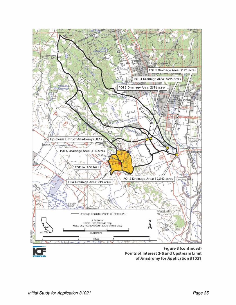
Jones & Stokes conducted a Water Availability Analysis and Cumulative Flow Impairment Index (WAA/CFII) report for the proposed project in December 2006 (Jones & Stokes 2006). This document is on file with the Division. The Division accepted the analysis on December 18, 20068. To assess the cumulative flow impairments of existing and pending projects in the watershed, the analysis included a CFII calculated for six Points of Interest (POIs). The CFII is defined as the ratio of all current and proposed withdrawals and diversions divided by the average unimpaired runoff from December 15-March 31. POIs were selected by DFG9 (California Department of Fish and Game 2004).
Table 5, below, summarizes information for each POI and the POD.
Table 5. Description and Source for Points of Interest
POI Description Source CFII Value (%)
1 Mouth of Sonoma Creek Division 3.64
2 Fowler Creek immediately upstream of confluence with Sonoma Creek Division 3.24
3 Rodgers Creek immediately upstream of confluence with Fowler Creek
Division 2.23
4 Rodgers Creek immediately downstream of confluence with Champlin Creek
DFG 2.51
5 Champlin Creek immediately upstream of confluence with Rodgers Creek
Division 4.02
6 Champlin Creek immediately downstream of confluence with unnamed stream below POD
DFG 30.96
8 The WAA/CFII report was updated on June 30, 2010 to incorporate a decrease in diversion upstream of Application 31021 (Application 30854) from 40 acre-feet per annum to 19 acre-feet per annum.
9 POIs were originally selected by Division staff. Upon review of a draft WAA/CFII report sent to DFG and NMFS on May 21, 2004, DFG requested analysis of two additional POIs.

Initial Study for Application 31021 Page 34
Figure 3 illustrates the watershed boundaries for the POIs.
Initial Study for Application 31021 Page 35

Initial Study for Application 31021 Page 36
Additionally, Division staff prepared a daily analysis (Tran 2010) to supplement the updated June 30, 2010 WAA/CFII report prepared by Jones & Stokes to (1) provide detailed information for use in evaluating whether the project meets the onstream dam exemption criteria in the DFG-NMFS Guidelines10; and (2) evaluate, on a daily basis, the availability of water needed to satisfy the diversion amount requested under Application 31021. Using the average unimpaired flow in acre-feet between the December 15-March 31 diversion season from Table A in the Division’s daily analysis (96,270 for POI 1; 15,757 for POI 2, 5,146 for POI 3; 4,569 for POI 4; 2,177 for POI 5; and 268 for POI 6) and the same diversion amounts used in the June 30, 2010 WAA/CFII report, all CFII values decrease to 3.49%, 2.44%, 1.68%, 1.89%, 3.10%, and 23.88%, respectively, for POIs 1-6.
Using the results from either methodology, the CFII at each POI is less than 5% for POIs 1 through 5. The relatively low CFII values indicate that there is sufficient water supply in the watershed for the proposed project and approval of the application should not adversely affect any senior water right holders. According to the DFG-NMFS Draft Guidelines the level of impairment identified by the CFII will determine the likely study effort needed to address the significance of cumulative impacts of a new water right project. In cases where the CFII is less than 5%, there is little chance of significant cumulative impacts due to the diversion and the project does not require additional studies to assess the impacts. Based on the CFII results, the consultants have concluded that impacts to water volumes and seasonal flow patterns from project implementation would be less than significant. There is no significant cumulative impact to the natural hydrograph of Champlin Creek as a result of the proposed project.
The high CFII value for POI 6 will affect the hydrology of Champlin Creek downstream of its confluence with the Unnamed Stream tributary below the POD; however, this portion of Champlin Creek is a first-order, ephemeral, headwater segment and is not a Class 1 (i.e., seasonally fish-bearing) stream until the point shown as Upstream Limit of Anadromy on Figure 3 and Impediment 4 on Figure 2 of the report entitled Martinelli Ranch (Application 31021) - Stream Classification and Upstream Limit of Anadromy Assessment of Unnamed Stream Tributary to Champlin Creek, thence Champlin Creek, thence Rodgers Creek, thence Fowler Creek, thence Sonoma Creek, thence San Pablo Bay, Sonoma County (December 17, 2009) (Final Version) (ICF Jones & Stokes 2010). The calculated CFII at this point, which is considered the upstream limit of anadromy for Application 31021, is 7.79% (using the rainfall-runoff method) or 8.04% (using the value from Table C in the Division’s daily analysis)11. Refer to Section 4, Biological Resources, below for additional information.
10
This analysis was completed prior to the Applicant’s June 7, 2011 Application Amendment to convert the POD from an instream reservoir to a sump and pump system that will deliver water to an offstream reservoir.
11 NMFS has indicated that for streams in non-coho, non-Chinook anadromous watersheds (steelhead-only streams), additional hydrological analysis is not needed where the CFII is less than 10% (Hearn pers. comm.). Refer to Section 4, Biological Resources, below for additional information.
Initial Study for Application 31021 Page 37
g iii. Would the change in the water volume and/or the pattern of seasonal flows in the affected watercourse result in a significant reduction in the available aquatic habitat or riparian habitat for native species of plants and animals?
As stated above, operation of the proposed reservoir and the POD will not significantly change the water volume and/or the pattern of seasonal flows in the affected watercourse thus not reducing the available aquatic habitat or riparian habitat for native species of plants or animals. After construction of the POD, concentrated runoff in the Unnamed Stream tributary to Champlin Creek will occur in the same manner it currently does – only when flows extend over the high water mark of the channel will water be collected and diverted to the proposed offstream reservoir. Furthermore, the POD will have a required bypass structure (a flow splitter), so a significant fraction of the hydrologic cycle will remain in the channel system. A portion of sheetflow occurring above (upstream of) the proposed reservoir will be captured in the reservoir while sheetflow occurring below the proposed reservoir will enter the waterway in a manner similar to pre-construction site conditions and will not be affected by the presence of the proposed reservoir.
Furthermore, compliance with the following permit term, substantially as follows, would ensure the proposed project does not result in any significant impacts to available aquatic habitat or riparian habitat for native species of plants or animals:
• No water shall be diverted under this right unless the flow in the unnamed stream is at or above 0.13 cubic foot per second, as determined at point of compliance as specified on map dated April 14, 2012 on file with the Division of Water Rights.
In addition to the permit term described above, a Proposed Bypass Flow Compliance Plan (Plan) will be submitted to the Division no later than six months after issuance if the water right permit12. Under the terms of this permit, the permittee is required to passively bypass all jurisdictional channel flows from incipient trickle up to a minimum of the FMF, which has been determined via WAA/CFII analysis to be 0.13 cubic feet per second (cfs) (58.3 gallons per minute [gal/min]) at the POD. Diversion to storage will occur only when flow is greater than 0.13 cfs. The permissible season of diversion shall be December 15 through March 31. The Plan will describe a design for future facilities and methodologies intended to produce the desired bypass flows. Potential key components of the Plan are summarized below.
12
Prior to the most recent adjustment to Application 31021 (before POD conversion from an onstream reservoir to a sump and pump system that will deliver water to an offstream reservoir), a bypass flow compliance plan was developed for the proposed project (Erickson Engineering 2008).
Initial Study for Application 31021 Page 38
Proposed Offstream Reservoir
• A pre-construction topographic survey will be used to determine site geometry necessary for design and placement of both bypass system components and the offstream reservoir. Reservoir design capacity will be consistent with the Appropriative water rights application. Post-construction survey work will be used for volumetric calibration of the completed reservoir, and for placement of a staff gage system.
Passive Bypass System
• A weir and off-channel sump chamber and pump system will be built on the Unnamed Stream tributary to Champlin Creek.
• The bypass diversion device will be designed so the required bypass flow will be diverted year round, and will use a flow splitter to control flows.
• The system will be sized for the 100-year design storm without overtopping.
• Bypass flows will be conveyed to a discharge point in the natural channel by either using low-slope channels or short pipe sections.
General Compliance Actions
• The bypass system and natural channel section upstream will be monitored to minimize risk of debris accumulation.
Non-Season of Diversion Compliance Actions
• All flows during the non-diversion period would be routed through the bypass system, which would be monitored to maintain operability.
Season of Diversion Compliance Actions
• During the diversion season flows in excess of 0.13 cfs would be diverted to the storage facility. The offstream reservoir is not expected to fill until late in the collection season. The diversion pump would be de-activated once the reservoir is filled. Any potential storage in excess of capacity due to rainfall or pumping operations will be returned to the channel via a piped overflow system. An emergency overflow will also be incorporated in the design for safety purposes.
Record Keeping and Reporting
• The permittee shall keep a log of weir observation and maintenance activities that should include information necessary to ensure compliance with permit restrictions and requirements.
• Monitoring data shall be maintained by the permittee for ten years from the date of collection and be made available to the Deputy Director for Water Rights.

Initial Study for Application 31021 Page 39
Schedule for Implementation
• The bypass system shall be constructed concurrently with construction of the offstream reservoir, and diversion and use of water prior to approval is not authorized.
Ongoing Maintenance
• The permittee shall be responsible for facility maintenance and inspection, and shall implement corrective action as required for satisfactory performance.
• Bypass flow system inspections shall occur at least weekly during the rainfall season, the frequency of which shall increase during the diversion season.
Modifications to Proposed Bypass Flow Compliance Plan
• The permittee reserves the right to propose changes in the Plan based on future design or operational changes; however, the scope of the Plan shall not be affected by any such proposed changes.
Channel Maintenance
Naturally occurring flows necessary for channel maintenance will still occur because operation of the diversion structure at the POD will not significantly change the water volume and/or the pattern of seasonal flows in the affected watercourse. The Unnamed Stream tributary to Champlin Creek is a well-vegetated grassy channel that appears only to support intermittent transport of fines (sand, silt, clay), as do the surrounding grassed hillslopes. Intermittent transport of fines within the channel occurs when they are delivered to the channel by naturally-occurring upland sheetflow runoff. After construction of the POD, a significant fraction of the hydrologic cycle and all related transport of upland fines will remain in the channel system. Sheetflow occurring below the POD will enter the waterway in a manner similar to preconstruction site conditions and will not be affected by the presence of the POD. Sediment delivery and transport to downstream reaches after proposed POD installation will therefore occur at approximately the same rate as at present.
Furthermore, the Unnamed Stream tributary to Champlin Creek is a normally dry, upland grassed channel that has experienced incision over the past century. Portions of the Unnamed Stream tributary would be considered as having active gully erosion with denuded, steep banks with significant bank retreat rates. A high rate of erosion is undesirable, as elevated levels of sand, silt, and clay, collectively and colloquially considered "mud", are delivered to downstream reaches. Mud has the tendency to plug the active channel, reducing hydraulic capacity and inducing lateral scour that perpetuates accelerated erosion elsewhere in the watershed. Mud is also believed detrimental to aquatic habitat, including spawning gravels, if they exist downstream.
Initial Study for Application 31021 Page 40
Removal of livestock, the normal agricultural practice in this area for the last century, and permit terms requiring an appropriate riparian setback (discussed below under Section 4, Biological Resources) as part of vineyard operation would enhance vegetative healing and restoration of the existing channel and gully. These practices would tend to reduce transport of fines to their historic pre-agricultural development levels and provide a benefit to downstream flora and fauna.
g iv and v. Would the change in the water volume and/or the pattern of seasonal flows in the affected watercourse result in: iv) a significant change in seasonal water temperatures due to changes in the patterns of water flow in the stream?; or v) a substantial increase or threat from invasive, non-native plants and wildlife?
The proposed project will not result in a change in the water volume and/or the pattern of seasonal flows in the affected watercourse that would cause either a significant change in seasonal water temperatures due to changes in the patterns of water flow in the stream or a substantial increase or threat from invasive, non-native plants and wildlife, for reasons discussed above and below in Section 4, Biological Resources.
Additional Terms
To ensure that water is diverted in accordance with the project description and to minimize the project’s potential to cause impacts to hydrology and water quality, the following permit terms, substantially as follows, shall be included in any permit or license issued pursuant to Application 31021:
• The capacity of the reservoir covered by this water right shall not exceed 45 af13.
• The water appropriated shall be limited to the quantity which can be beneficially used and shall not exceed 45 af per year by storage to be collected from December 15 of each year to March 31 of the succeeding year.
• No water shall be diverted to offstream storage under this right unless permittee is monitoring and reporting said diversion of water. This monitoring shall be conducted using a device and methods satisfactory to the Deputy Director for Water Rights. The device shall be capable of continuous monitoring of the rate and quantity of water diverted and shall be properly maintained.
Permittee shall provide the Division of Water Rights with evidence that the device has been installed with the first annual report submitted after device installation. Permittee shall provide the Division of Water Rights with evidence that substantiates that the device is functioning properly every five years after device installation as an enclosure to the current annual report or whenever requested by the Division of Water Rights.
Permittee shall maintain a record of all diversions under this right that includes the date, time, rate of diversion at time intervals of one hour or less, and the
13
As calculated in the Division’s daily analysis (Tran 2010), the full amount requested under Application 31021 (45 af) was available in 12 of the 26 years of record (1956-1981).
Initial Study for Application 31021 Page 41
amount of water diverted. The records shall be submitted with the annual report or whenever requested by the Division of Water Rights.
• No water shall be diverted under this right unless permittee is operating in accordance with a compliance plan, satisfactory to the Deputy Director for Water Rights. Said compliance plan shall specify how permittee will comply with the terms and conditions of this right. Permittee shall comply with all reporting requirements in accordance with the schedule contained in the compliance plan.
• Based on the information in the Division’s files, water has not been used under a claimed existing right on the place of use. If permittee exercises a claimed existing right on the place of use authorized by this right without prior approval from the State Water Board, permittee shall forfeit this water right.
• Permittee shall report any non-compliance with the terms of the permit to the Deputy Director for Water Rights within three days of identification of the violation.
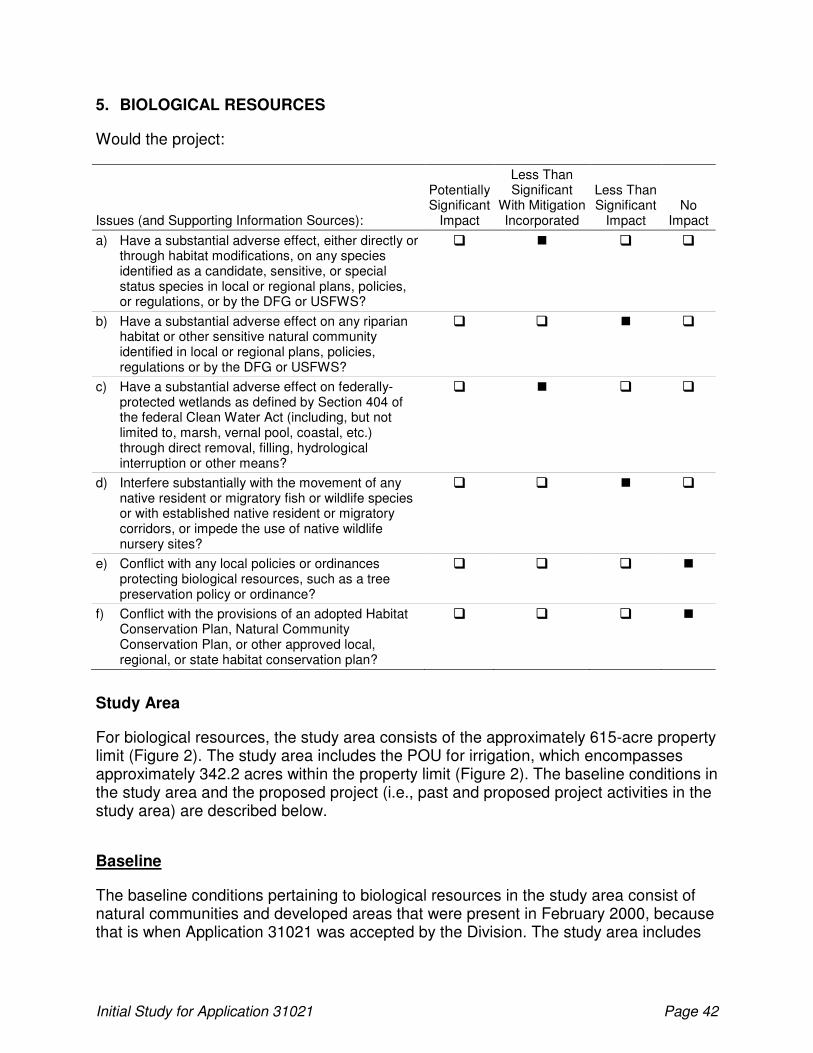
Initial Study for Application 31021 Page 42
5. BIOLOGICAL RESOURCES
Would the project:
Issues (and Supporting Information Sources):
Potentially Significant
Impact
Less Than Significant
With Mitigation Incorporated
Less Than Significant
Impact No
Impact
a) Have a substantial adverse effect, either directly or through habitat modifications, on any species identified as a candidate, sensitive, or special status species in local or regional plans, policies, or regulations, or by the DFG or USFWS?
� � � �
b) Have a substantial adverse effect on any riparian habitat or other sensitive natural community identified in local or regional plans, policies, regulations or by the DFG or USFWS?
� � � �
c) Have a substantial adverse effect on federally-protected wetlands as defined by Section 404 of the federal Clean Water Act (including, but not limited to, marsh, vernal pool, coastal, etc.) through direct removal, filling, hydrological interruption or other means?
� � � �
d) Interfere substantially with the movement of any native resident or migratory fish or wildlife species or with established native resident or migratory corridors, or impede the use of native wildlife nursery sites?
� � � �
e) Conflict with any local policies or ordinances protecting biological resources, such as a tree preservation policy or ordinance?
� � � �
f) Conflict with the provisions of an adopted Habitat Conservation Plan, Natural Community Conservation Plan, or other approved local, regional, or state habitat conservation plan?
� � � �
Study Area
For biological resources, the study area consists of the approximately 615-acre property limit (Figure 2). The study area includes the POU for irrigation, which encompasses approximately 342.2 acres within the property limit (Figure 2). The baseline conditions in the study area and the proposed project (i.e., past and proposed project activities in the study area) are described below.
Baseline
The baseline conditions pertaining to biological resources in the study area consist of natural communities and developed areas that were present in February 2000, because that is when Application 31021 was accepted by the Division. The study area includes
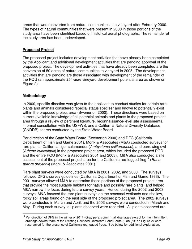
Initial Study for Application 31021 Page 43
areas that were converted from natural communities into vineyard after February 2000. The types of natural communities that were present in 2000 in those portions of the study area have been identified based on historical aerial photographs. The remainder of the study area has been undeveloped.
Proposed Project
The proposed project includes development activities that have already been completed by the Applicant and additional development activities that are pending approval of the proposed project. The development activities that have already been completed are the conversion of 50 acres of natural communities to vineyard in 2005. The development activities that are pending are those associated with development of the remainder of the POU (an approximate 254-acre vineyard development potential area as shown on Figure 2).
Methodology
In 2000, specific direction was given to the applicant to conduct studies for certain rare plants and animals considered “special status species” and known to potentially exist within the proposed project area (Swenerton 2000). These directions were based on current available knowledge of all potential animals and plants in the proposed project area through a review of pertinent literature, reconnaissance-level site assessments, informal consultation with the USFWS, and a California Natural Diversity Database (CNDDB) search conducted by the State Water Board.
Per direction of the State Water Board (Swenerton 2000) and DFG (California Department of Fish and Game 2001), Monk & Associates (M&A) conducted surveys for rare plants, California tiger salamander (Ambystoma californiense), and burrowing owl (Athene cunicularia) in the proposed project area, which included the proposed POD and the entire POU (Monk & Associates 2001 and 2003). M&A also conducted a site assessment of the proposed project area for the California red-legged frog14 (Rana aurora draytonii) (Monk & Associates 2001).
Rare plant surveys were conducted by M&A in 2001, 2002, and 2003. The surveys followed DFG’s survey guidelines (California Department of Fish and Game 1983). The 2001 surveys allowed M&A to determine those portions of the proposed project area that provide the most suitable habitats for native and possibly rare plants, and helped M&A narrow the focus during future survey years. Hence, during the 2002 and 2003 surveys, M&A focused the rare plant surveys on the seasonal wetlands and shallow, rocky soil areas found on the east side of the proposed project area. The 2002 surveys were conducted in March and April, and the 2003 surveys were conducted in March and May. During each survey, all plants observed were recorded. All plants observed are
14
Per direction of DFG in the winter of 2011 (Gray pers. comm.), all drainages except for the intermittent drainage downstream of the Existing Licensed Onstream Pond South (9 af) (“B” on Figure 2) were resurveyed for the presence of California red-legged frogs. See below for additional explanation.
Initial Study for Application 31021 Page 44
listed in Table 2 of the M&A (2003) report. During three years of appropriately timed surveys, two rare plants were identified: Contra Costa goldfields (Lasthenia conjugens) and Lobb’s aquatic buttercup (Ranunculus lobbii). These two plants are discussed below. M&A conducted surveys for burrowing owl within the proposed project area in February, May, and June 2001 (Monk & Associates 2001). The burrowing owl surveys were conducted to comply with the Division’s requirements (State Water Resources Control Board 2000b). M&A did not observe burrowing owls during the survey and determined that the proposed project area did provide suitable habitat for burrowing owl at the time of the surveys. M&A conducted a habitat assessment for California red- legged frog on February 15, 2001 within the proposed project area (Monk & Associates 2001). The California red-legged frog site assessment was conducted to comply with the Division’s requirements (State Water Resources Control Board 2000b). During this site assessment all seasonal wetlands, drainages, and permanent ponds were evaluated as to their potential as California red-legged frog habitat. Several juvenile California red-legged frogs were identified during the site assessment. Because California red-legged frogs were observed during the site assessment, it was determined that follow-up, protocol-level surveys would not be necessary. However, M&A did dip net and placed minnow traps within existing ponds on May 17 and 29, 2001. No larval, juvenile, or adult California red-legged frogs were observed. Bullfrog adults, a few bullfrog larvae, and one adult western pond turtle (Actinemys marmorata) were observed during these surveys. There are no historical or recent records for California tiger salamander in or near the vicinity of the proposed project area. M&A conducted surveys for California tiger salamander larval surveys over a 2-year period in the springs of 2002 and 2003 (Monk & Associates 2003). The California tiger salamander surveys were conducted to satisfy DFG and the State Water Board requirements (California Department of Fish and Game 2001). No California tiger salamanders were identified during the 2002 and 2003 surveys. While the aquatic habitats in the study area appear suitable for California tiger salamander, it is likely that California tiger salamanders do not occur in this part of Sonoma County (Monk & Associates 2003). In 2008, a list of regionally occurring special-status plant and animal species was prepared based on the results of a CNDDB (2008) (Figure 4) query of all reported occurrences of special-status species within the project region (Table 6). The review was conducted to determine if changes to potentially occurring special status species have occurred since surveys were conducted by M&A in 2001 and 2003. The proposed project area contains known occurrences of two special-status plants and two special-status wildlife species. An additional special status wildlife species, burrowing owl, has the potential to occur in the proposed project area. The current regulatory status, habitat requirements, and presence within the project area for all occurring, or potentially occurring, special status species is described below.

Initial Study for Application 31021 Page 45
As footnoted above, all drainages except for the intermittent drainage downstream of the Existing Licensed Onstream Pond South15 (9 af) (“B” on Figure 2) were resurveyed for California red-legged frogs. Surveys16 were conducted in the 2011 season. The avoidance measures described below take into account the results of these recent surveys.
15
California red-legged frogs were found in this drainage during the original surveys. As such, DFG has agreed that resurvey of this drainage in 2011 was not necessary (Gray pers. comm.). See below for additional information and the proposed avoidance measure for this area.
16 Current USFWS Guidance (“Revised Guidance on Site Assessments and Field Surveys for the California Red-legged Frog”, August 2005) was used as the protocol to resurvey. Two day surveys and four night surveys are recommended during the breeding season; one day and one night survey is recommended during the non-breeding season. According to USFWS Guidance, the non-breeding season is between July 1 and September 30. Hence, following this guidance, M&A biologists conducted 3 diurnal (day time) surveys on the property: April 4, April 22, and August 8, 2011. M&A biologists also conducted 5 nocturnal (night time) surveys on the property: April 11, April 18, May 4, June 22, and July 18, 2011.

Initial Study for Application 31021 Page 46

Initial Study for Application 31021 Page 47
Table 6. Special-Status Wildlife and Plant Species Identified as Having the Potential to Occur in the Project Region
Common Name and Scientific Name
Legal Statusa
Fed/State/ CNPS Geographic Distribution Habitat Requirements
Blooming Period
Potential Occurrence in the Study Area
b
Invertebrates
California freshwater shrimp Syncaris pacifica
E/E/– Endemic to Marin, Napa, and Sonoma Counties; extant populations in Lagunitas Creek in Marin Co., Huichica Creek in Napa Co., and Franz, East Austin, Sonoma, and Salmon Creeks in Sonoma Co.
In pool areas of low-elevation, low gradient, permanent streams; among live tree roots of undercut banks, under overhanging woody debri or vegetation
– None—The proposed project is not likely to affect California freshwater shrimp because the species is not known to occur at, or downstream of, the proposed project area (Cox pers. comm.)
Amphibians
California tiger salamander Ambystoma californiense
T/C/– Central Valley, including Sierra Nevada foothills, up to approximately 1,000 feet, and coastal region from Butte County south to northeastern San Luis Obispo County
Small ponds, lakes, or vernal pools in grasslands and oak woodlands for larvae; rodent burrows, rock crevices, or fallen logs for cover for adults and for summer dormancy
– None—none observed in study area (Monk and Associates 2003) and study area is outside the current range of the species; the closest reported occurrences occur more than 5 miles west from the study area (USFWS 2004)
California red-legged frog Rana aurora draytonii
T/SSC/– Found along the coast and coastal mountain ranges of California from Marin County to San Diego County and in the Sierra Nevada from Tehama County to Fresno County
Permanent and semipermanent aquatic habitats, such as creeks and coldwater ponds, with emergent and submergent vegetation. May aestivate in rodent burrows or cracks during dry periods
– High—observed within the study area
Foothill yellow-legged frog Rana boylii
–/SSC/– Occurs in Klamath, Cascade, north and south Coast, and Transverse Ranges, and Sierra Nevada up to approximately 6,000 feet
Creeks or rivers in woodland, forest, mixed chaparral, and wet meadow habitats with rock and gravel substrate and low overhanging vegetation along edge. Usually found near riffles with rocks and sunny banks nearby
– None—No suitable habitat within study area
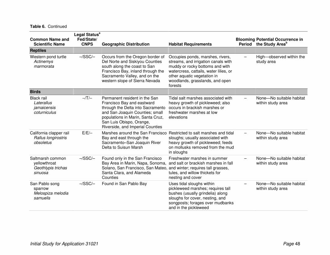
Table 6. Continued
Initial Study for Application 31021 Page 48
Common Name and Scientific Name
Legal Statusa
Fed/State/ CNPS Geographic Distribution Habitat Requirements
Blooming Period
Potential Occurrence in the Study Area
b
Reptiles
Western pond turtle Actinemys marmorata
–/SSC/– Occurs from the Oregon border of Del Norte and Siskiyou Counties south along the coast to San Francisco Bay, inland through the Sacramento Valley, and on the western slope of Sierra Nevada
Occupies ponds, marshes, rivers, streams, and irrigation canals with muddy or rocky bottoms and with watercress, cattails, water lilies, or other aquatic vegetation in woodlands, grasslands, and open forests
– High—observed within the study area
Birds
Black rail Laterallus jamaicensis coturniculus
–/T/– Permanent resident in the San Francisco Bay and eastward through the Delta into Sacramento and San Joaquin Counties; small populations in Marin, Santa Cruz, San Luis Obispo, Orange, Riverside, and Imperial Counties
Tidal salt marshes associated with heavy growth of pickleweed; also occurs in brackish marshes or freshwater marshes at low elevations
– None—No suitable habitat within study area
California clapper rail Rallus longirostris obsoletus
E/E/– Marshes around the San Francisco Bay and east through the Sacramento–San Joaquin River Delta to Suisun Marsh
Restricted to salt marshes and tidal sloughs; usually associated with heavy growth of pickleweed; feeds on mollusks removed from the mud in sloughs
– None—No suitable habitat within study area
Saltmarsh common yellowthroat Geothlypis trichas sinuosa
–/SSC/– Found only in the San Francisco Bay Area in Marin, Napa, Sonoma, Solano, San Francisco, San Mateo, Santa Clara, and Alameda Counties
Freshwater marshes in summer and salt or brackish marshes in fall and winter; requires tall grasses, tules, and willow thickets for nesting and cover
– None—No suitable habitat within study area
San Pablo song sparrow Melospiza melodia samuelis
–/SSC/– Found in San Pablo Bay Uses tidal sloughs within pickleweed marshes; requires tall bushes (usually grindelia) along sloughs for cover, nesting, and songposts; forages over mudbanks and in the pickleweed
– None—No suitable habitat within study area
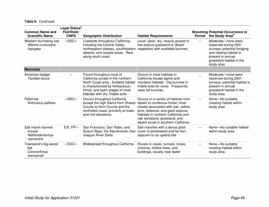
Table 6. Continued
Initial Study for Application 31021 Page 49
Common Name and Scientific Name
Legal Statusa
Fed/State/ CNPS Geographic Distribution Habitat Requirements
Blooming Period
Potential Occurrence in the Study Area
b
Western burrowing owl Athene cunicularia hypugea
–/SSC/– Lowlands throughout California, including the Central Valley, northeastern plateau, southeastern deserts, and coastal areas. Rare along south coast
Level, open, dry, heavily grazed or low-stature grassland or desert vegetation with available burrows
– Moderate—none were observed during 2001 surveys; potential foraging and nesting habitat is present in annual grassland habitat in the study area
Mammals
American badger Taxidea taxius
-- Found throughout most of California except in the northern North Coast area. Suitable habitat is characterized by herbaceous, shrub, and open stages of most habitats with dry, friable soils.
Occurs in most habitats in California except alpine and montane habitats. Dig burrows in friable soils for cover. Frequently uses old burrows.
_ Moderate—none were observed during 2001 surveys; potential habitat is present in annual grassland habitat in the study area
Pallid bat Antrozous pallidus
–/SSC/– Occurs throughout California except the high Sierra from Shasta County to Kern County and the northwest coast, primarily at lower and mid elevations
Occurs in a variety of habitats from desert to coniferous forest; most closely associated with oak, yellow pine, redwood, and giant sequoia habitats in northern California and oak woodland, grassland, and desert scrub in southern California
– None—No suitable roosting habitat within study area
Salt marsh harvest mouse Reithrodontomys raviventris
E/E, FP/– San Francisco, San Pablo, and Suisun Bays; the Sacramento–San Joaquin River Delta
Salt marshes with a dense plant cover of pickleweed and fat hen; adjacent to an upland site
– None—No suitable habitat within study area
Townsend’s big-eared bat Corynorhinus townsendii
–/SSC/– Widespread throughout California Roosts in caves, tunnels, mines, crevices, hollow trees, and buildings, usually near water
– None—No suitable roosting habitat within study area

Table 6. Continued
Initial Study for Application 31021 Page 50
Common Name and Scientific Name
Legal Statusa
Fed/State/ CNPS Geographic Distribution Habitat Requirements
Blooming Period
Potential Occurrence in the Study Area
b
Plants
Franciscan onion Allium peninsulare var. franciscanum
–/–/1B.2 Central Coast, San Francisco Bay region: Santa Clara, San Mateo, and Sonoma Counties
Clay and often serpentine soils in cismontane woodland, valley and foothill grassland; 52–300 meters
May–Jun None—Not located in the study area during surveys.
Napa false indigo Amorpha californica var. napensis
–/–/1B.2 Monterey, Marin, Napa, and Sonoma Counties
Openings in broadleaved upland forest, cismontane woodland, chaparral; 150–2,000 meters
Apr–Jul None—Not located in the study area during surveys.
Alkali milk-vetch Astragalus tener var. tener
–/–/1B.2 Southern Sacramento Valley, northern San Joaquin Valley, east San Francisco Bay Area
Playas, on adobe clay in valley and foothill grassland, vernal pools on alkaline soils; below 60 meters
Mar–Jun None—Not located in the study area during surveys.
Sonoma spineflower Chorizanthe valida
E/E/1B.1 Marin and Sonoma* Counties Sandy soils of coastal prairie; 10–305 meters
Jun–Aug None—Not located in the study area during surveys.
Point Reyes bird’s-beak Cordylanthus maritimus ssp. palustris
–/–/1B.2 Coastal northern California, from Humboldt to Santa Clara County; Oregon
Coastal salt marsh;below 10 meters
Jun–Oct None—Not located in the study area during surveys.
Soft bird’s-beak Cordylanthus mollis ssp. mollis
E/R/1B.2 San Francisco Bay region: Suisun Marsh, Contra Costa, Marin*, Napa, Solano, Sacramento*, and Sonoma* Counties
Tidal salt marsh; below 3 meters Jul–Nov None—Not located in the study area during surveys.
Yellow larkspur Delphinium luteum
E/R/1B.1 Endemic to Marin and Sonoma Counties, near Bodega Bay
Rocky areas in chaparral, coastal prairie, coastal scrub; below 100 meters
Mar–May None—Not located in the study area during surveys.
Round-leaved filaree Erodium (syn. California) macrophyllum
–/–/2.1 Scattered occurrences in the Great Valley, southern North Coast Ranges, San Francisco Bay Area, South Coast Ranges, Channel Islands, Transverse Ranges, and Peninsular Ranges
Cismontane woodland, valley and foothill grassland on clay soils; 15–1,200 meters
Mar–May None—Not located in the study area during surveys.
Fragrant fritillary Fritillaria liliacea
–/–/1B.2 Coast Ranges from Marin County to San Benito County
Adobe soils of interior foothills, coastal prairie, coastal scrub, Valley and foothill grassland, often on serpentinite; 3–410 meters
Feb–Apr None—Not located in the study area during surveys.
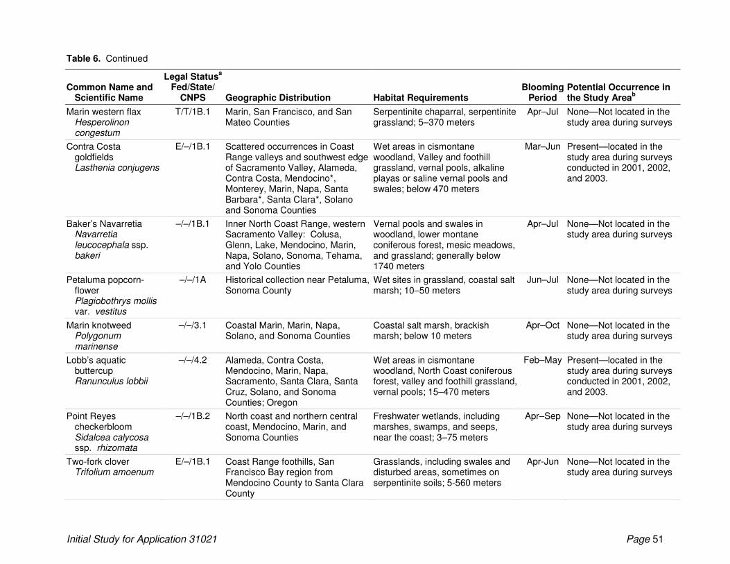
Table 6. Continued
Initial Study for Application 31021 Page 51
Common Name and Scientific Name
Legal Statusa
Fed/State/ CNPS Geographic Distribution Habitat Requirements
Blooming Period
Potential Occurrence in the Study Area
b
Marin western flax Hesperolinon congestum
T/T/1B.1 Marin, San Francisco, and San Mateo Counties
Serpentinite chaparral, serpentinite grassland; 5–370 meters
Apr–Jul None—Not located in the study area during surveys
Contra Costa goldfields Lasthenia conjugens
E/–/1B.1 Scattered occurrences in Coast Range valleys and southwest edge of Sacramento Valley, Alameda, Contra Costa, Mendocino*, Monterey, Marin, Napa, Santa Barbara*, Santa Clara*, Solano and Sonoma Counties
Wet areas in cismontane woodland, Valley and foothill grassland, vernal pools, alkaline playas or saline vernal pools and swales; below 470 meters
Mar–Jun Present—located in the study area during surveys conducted in 2001, 2002, and 2003.
Baker’s Navarretia Navarretia leucocephala ssp. bakeri
–/–/1B.1 Inner North Coast Range, western Sacramento Valley: Colusa, Glenn, Lake, Mendocino, Marin, Napa, Solano, Sonoma, Tehama, and Yolo Counties
Vernal pools and swales in woodland, lower montane coniferous forest, mesic meadows, and grassland; generally below 1740 meters
Apr–Jul None—Not located in the study area during surveys
Petaluma popcorn-flower Plagiobothrys mollis var. vestitus
–/–/1A Historical collection near Petaluma, Sonoma County
Wet sites in grassland, coastal salt marsh; 10–50 meters
Jun–Jul None—Not located in the study area during surveys
Marin knotweed Polygonum marinense
–/–/3.1 Coastal Marin, Marin, Napa, Solano, and Sonoma Counties
Coastal salt marsh, brackish marsh; below 10 meters
Apr–Oct None—Not located in the study area during surveys
Lobb’s aquatic buttercup Ranunculus lobbii
–/–/4.2 Alameda, Contra Costa, Mendocino, Marin, Napa, Sacramento, Santa Clara, Santa Cruz, Solano, and Sonoma Counties; Oregon
Wet areas in cismontane woodland, North Coast coniferous forest, valley and foothill grassland, vernal pools; 15–470 meters
Feb–May Present—located in the study area during surveys conducted in 2001, 2002, and 2003.
Point Reyes checkerbloom Sidalcea calycosa ssp. rhizomata
–/–/1B.2 North coast and northern central coast, Mendocino, Marin, and Sonoma Counties
Freshwater wetlands, including marshes, swamps, and seeps, near the coast; 3–75 meters
Apr–Sep None—Not located in the study area during surveys
Two-fork clover Trifolium amoenum
E/–/1B.1 Coast Range foothills, San Francisco Bay region from Mendocino County to Santa Clara County
Grasslands, including swales and disturbed areas, sometimes on serpentinite soils; 5-560 meters
Apr-Jun None—Not located in the study area during surveys
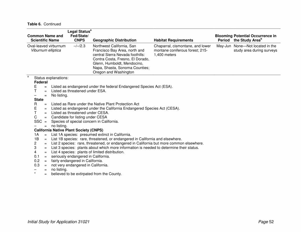
Table 6. Continued
Initial Study for Application 31021 Page 52
Common Name and Scientific Name
Legal Statusa
Fed/State/ CNPS Geographic Distribution Habitat Requirements
Blooming Period
Potential Occurrence in the Study Area
b
Oval-leaved virburnum Viburnum elliptica
–/–/2.3 Northwest California, San Francisco Bay Area, north and central Sierra Nevada foothills: Contra Costa, Fresno, El Dorado, Glenn, Humboldt, Mendocino, Napa, Shasta, Sonoma Counties; Oregon and Washington
Chaparral, cismontane, and lower montane coniferous forest; 215-1,400 meters
May-Jun None—Not located in the study area during surveys
a Status explanations:
Federal E = Listed as endangered under the federal Endangered Species Act (ESA). T = Listed as threatened under ESA. – = No listing. State R = Listed as Rare under the Native Plant Protection Act E = Listed as endangered under the California Endangered Species Act (CESA). T = Listed as threatened under CESA. C = Candidate for listing under CESA SSC = Species of special concern in California. – = no listing. California Native Plant Society (CNPS) 1A = List 1A species: presumed extinct in California. 1B = List 1B species: rare, threatened, or endangered in California and elsewhere. 2 = List 2 species: rare, threatened, or endangered in California but more common elsewhere. 3 = List 3 species: plants about which more information is needed to determine their status. 4 = List 4 species: plants of limited distribution. 0.1 = seriously endangered in California. 0.2 = fairly endangered in California. 0.3 = not very endangered in California. – = no listing. * = believed to be extirpated from the County.
Table 6. Continued
Initial Study for Application 31021 Page 53
b Potential occurrence in the study area:
Present: Known to occur in the project area based on California Natural Diversity Database records; or observed during surveys. High: California Natural Diversity Database (or other documents) records known occurrence of species in the project vicinity; or
presence of suitable habitat conditions and suitable microhabitat conditions. Moderate: California Natural Diversity Database (or other documents) records known occurrence of species in the project vicinity; or
presence of suitable habitat conditions but suitable microhabitat conditions are not present. Low: California Natural Diversity Database (or other documents) records no known occurrence of species in the project vicinity; or
habitat conditions of poor quality. None: California Natural Diversity Database (or other documents) records no known occurrence of species in the project vicinity; or
suitable habitat not present in any condition.
Initial Study for Application 30745 Page 54
Regulatory Setting
This section provides an overview of the laws and regulations that influence the management of biological resources in the project area. Although many of these regulations will not apply to the project if the resources in question are avoided, they are discussed here to provide context in determining which biological resources are considered sensitive for the purposes of this report and to discuss potential project-related effects.
Federal Regulations
Endangered Species Act
USFWS and the NMFS have jurisdiction over species listed as threatened or endangered under Section 9 of the ESA. In general, NMFS is responsible for protection of ESA-listed marine species and anadromous fish, and USFWS is responsible for other listed species. ESA protects listed species from harm, or take, which is broadly defined as to “harass, harm, pursue, hunt, shoot, wound, kill, trap, capture, or collect, or attempt to engage in any such conduct.” For any project involving a federal agency (in this case, the USACE) in which a listed species could be affected, the federal agency must consult with USFWS in accordance with Section 7 of ESA. USFWS issues a biological opinion (BiOp) and, if the project does not jeopardize the continued existence of the listed species, issues an incidental take permit. When no federal nexus is present, proponents of a project affecting a listed species must consult with USFWS and apply for an incidental take permit under Section 10 of ESA. Section 10 requires an applicant to submit a habitat conservation plan (HCP) that specifies project impacts and mitigation measures. Consultation with USFWS will be required if the proposed project will affect federally listed species or their habitat.
Section 404 of the Clean Water Act
The CWA was enacted as an amendment to the federal Water Pollution Control Act of 1972, which outlined the basic structure for regulating discharges of pollutants to waters of the United States. The CWA serves as the primary federal law protecting the quality of the nation’s surface waters, including lakes, rivers, and coastal wetlands.
The CWA empowers the EPA to set national water quality standards and effluent limitations and includes programs addressing both point-source and nonpoint-source pollution. Point-source pollution is pollution that originates or enters surface waters at a single, discrete location, such as an outfall structure or an excavation or construction site. Nonpoint-source pollution originates over a broader area and includes urban contaminants in stormwater runoff and sediment loading from upstream areas. The CWA operates on the principle that all discharges into the nation’s waters are unlawful unless specifically authorized by a permit; permit review is the CWA’s primary
Initial Study for Application 30745 Page 55
regulatory tool. The following sections provide additional details on specific sections of the CWA.
Permits for Fill Placement in Waters and Wetlands (Section 404)
CWA Section 404 regulates the discharge of dredged and fill materials into waters of the United States, which are oceans, bays, rivers, streams, lakes, ponds, and wetlands, including any or all of:
• Areas within the OHWM of a stream, including non-perennial streams with a defined bed and bank and any stream channel that conveys natural runoff, even if it has been realigned.
• Seasonal and perennial wetlands, including coastal wetlands.
On January 9, 2001, the U.S. Supreme Court made a decision in Solid Waste Agency of Northern Cook County v. United States Army Corps of Engineers (SWANCC) [121 S.CT. 675, 2001] that affected the USACE’s jurisdiction in isolated waters. Based on SWANCC, the USACE no longer has jurisdiction or regulates isolated wetlands (i.e., wetlands that have no hydrologic connection with water of the United States).
More recently, a federal ruling on two consolidated cases (June 19, 2006; Rapanos v. United States and Carabell v. U.S. Army Corps of Engineers), referred to as the Rapanos decision, affects whether some waters or wetlands are considered jurisdictional under the CWA. In these cases, the U.S. Supreme Court reviewed the USACE's definition of waters of the United States and whether it extended to tributaries of traditional navigable waters (TNW) or wetlands adjacent to those tributaries. The decision provided two standards for determining jurisdiction of water bodies that are not TNWs:
4. If the non-TNW is a relatively permanent water (RPW) or is a wetland directly connected to an RPW, or
5. If the water body has “significant nexus” to a TNW. The significant nexus definition is based on the purpose of the CWA (“restore and maintain the chemical, physical, and biological integrity of the Nation’s waters”).
Guidance issued by the EPA and USACE on the Rapanos decision requires application of these two standards and use of substantially more documentation to support a jurisdictional determination for a water body.
Applicants must obtain a permit from the USACE for all discharges of dredged or fill material into waters of the United States, including adjacent wetlands, before proceeding with a proposed activity. The USACE may issue either an individual permit evaluated on a case-by-case basis or a general permit evaluated at a program level for a series of related activities. General permits are preauthorized and are issued to cover multiple instances of similar activities expected to cause only minimal adverse environmental effects. The nationwide permits (NWPs) are a type of general permit

Initial Study for Application 30745 Page 56
issued to cover particular fill activities. Each NWP specifies particular conditions that must be met for the NWP to apply to a particular project.
Compliance with CWA Section 404 requires compliance with several other environmental laws and regulations. The USACE cannot issue an individual permit or verify the use of a general permit until the requirements of the National Environmental Policy Act (NEPA), ESA, and the National Historic Preservation Act have been met. In addition, the USACE cannot issue or verify any permit until a water quality certification or a waiver of certification has been issued pursuant to CWA Section 401.
Permits for Stormwater Discharge (Section 402)
CWA Section 402 regulates construction-related stormwater discharges to surface waters through the NPDES program, administered by EPA. In California, the State Water Board is authorized by EPA to oversee the NPDES program through the RWQCBs (see the related discussion under State of California, Porter-Cologne Water Quality Control Act). The study area is located within the jurisdiction of the San Francisco Bay RWQCB.
NPDES permits are required for projects that disturb more than 1 acre of land. The NPDES permitting process requires the applicant to file a public notice of intent (NOI) to discharge stormwater, and to prepare and implement a stormwater pollution prevention plan (SWPPP). The SWPPP includes a site map and a description of proposed construction activities. In addition, it describes the BMPs that would be implemented to prevent soil erosion and discharge of other construction-related pollutants (e.g., petroleum products, solvents, paints, cement) that could contaminate nearby water resources. Applicants are required to conduct annual monitoring and reporting to ensure that BMPs are implemented correctly and effective in controlling the discharge of stormwater-related pollutants.
Water Quality Certification (Section 401)
Under CWA Section 401, applicants for a federal license or permit to conduct activities that may result in the discharge of a pollutant into waters of the United States must obtain certification from the state in which the discharge would originate or, if appropriate, from the interstate water pollution control agency with jurisdiction over affected waters at the point where the discharge would originate. Therefore, all projects that have a federal component and may affect state water quality (including projects that require federal agency approval, such as issuance of a Section 404 permit) also must comply with CWA Section 401.
Migratory Bird Treaty Act
The Migratory Bird Treaty Act (MBTA) (Title 16, United States Code [USC], Part 703) enacts the provisions of treaties between the United States, Great Britain, Mexico, Japan, and the former Soviet Union and authorizes the U.S. Secretary of the Interior to
Initial Study for Application 30745 Page 57
protect and regulate the taking of migratory birds. It establishes seasons and bag limits for hunted species and protects migratory birds, their occupied nests, and their eggs (16 USC 703, 50 Code of Federal Regulations [CFR] 21, 50 CFR 10). Most actions that result in taking of or the permanent or temporary possession of a protected species constitute violations of the MBTA. The MBTA also prohibits destruction of occupied nests. The Migratory Bird Permit Memorandum (MBPM-2) dated April 15, 2003, clarifies that destruction of most unoccupied bird nests is permissible under the MBTA; exceptions include nests of federally listed threatened or endangered migratory birds and bald eagles and golden eagles. USFWS is responsible for overseeing compliance with the MBTA. Most bird species and their occupied nests that occur in the proposed project area would be protected under the MBTA.
State of California
California Environmental Quality Act
CEQA is the regulatory framework by which California public agencies identify and mitigate significant environmental impacts. Although threatened and endangered species are protected by specific federal and state laws, the State CEQA Guidelines Section 15380(b) provides that a species not listed under ESA or CESA may be considered rare or endangered if it can be shown that the species meets certain specific criteria. The criteria have been modeled after the definitions of ESA and sections of the California Fish and Game Code discussing rare and endangered plants and animals.
A project normally is considered to result in a significant environmental effect (in the context of biological resources) if it substantially affects a rare or endangered species or the habitat of that species; substantially interferes with the movement of resident or migratory fish or wildlife; or substantially diminishes habitat for fish, wildlife, or plants. The State CEQA Guidelines define rare, threatened, or endangered species as those listed under ESA and CESA, as well as any other species that meets the criteria of the resource agencies or local agencies—for example, the DFG-designated species of special concern and plant species assigned a Rare Plant Rank by DFG. The State CEQA Guidelines specify that the lead agency preparing a CEQA compliance document must consult with and receive written findings from USFWS and DFG concerning project impacts on species that are listed as endangered or threatened. The effects of the project on these species and habitats will be important in determining whether the project is considered to cause significant environmental impacts under CEQA.
California Endangered Species Act
California implemented CESA in 1984. The act prohibits the take of endangered and threatened species; however, habitat destruction is not included in the state’s definition of take. Under CESA, take is defined as an activity that would directly or indirectly kill an individual of a species, but the definition does not include harm or harassment. Section 2090 of CESA requires state agencies to comply with endangered species protection and recovery and promote conservation of these species. DFG administers the act and
Initial Study for Application 30745 Page 58
authorizes take through Section 2081 agreements (except for species designated as fully protected). Regarding rare plant species, CESA defers to the California Native Plant Protection Act of 1977 (CNPPA), which prohibits importing rare and endangered plants into California, taking rare and endangered plants, and selling rare and endangered plants. State-listed plants are protected mainly in cases where state agencies are involved in projects under CEQA. In these cases, plants listed as rare under the CNPPA are not protected under CESA but can be protected under CEQA.
California Native Plant Protection Act
The CNPPA prohibits importation of rare and endangered plants into California, take of rare and endangered plants, and sale of rare and endangered plants. The CESA defers to the CNPPA, which ensures that state-listed plant species are protected when state agencies are involved in projects subject to CEQA. In this case, plants listed as rare under the CNPPA are not protected under CESA but rather under CEQA.
California Fish and Game Code
Sections 3503 and 3503.5
Section 3503 of the California Fish and Game Code prohibits the killing of birds and/or the destruction of occupied bird nests. Section 3503.5 prohibits the killing of raptor species and/or the destruction of occupied raptor nests. Consultation with DFG will be required if nesting birds would be affected by project-related activities.
Section 3511 (Fully Protected Birds)
The California Fish and Game Code provides protection from take for a variety of species, referred to as fully protected species. Section 3511 lists fully protected birds and prohibits take of these species. The California Fish and Game Code defines take as “hunt, pursue, catch, capture, or kill, or attempt to hunt, pursue, catch, capture, or kill.” Except for take related to scientific research, all take of fully protected species is prohibited.
Section 3513
Section 3513 of the California Fish and Game Code prohibits the take or possession of any migratory nongame bird as designated in the MBTA or any part of such migratory nongame bird except as provided by rules and regulations adopted by the Secretary of the Interior under provisions of the MBTA.
Initial Study for Application 30745 Page 59
Section 4700 (Fully Protected Mammals)
Section 4700 of the code lists fully protected mammals and prohibits take of these species. Except for take related to scientific research, all take of fully protected species is prohibited.
Section 1602—Lake and Streambed Alteration Agreements
Section 1602 of the California Fish and Game Code requires project proponents to notify DFG before implementing any project that would divert, obstruct, or change the natural flow, bed, channel, or bank of any river, stream, or lake. Preliminary notification and project review generally occur during the environmental process. When an existing fish or wildlife resource may be substantially adversely affected, DFG is required to propose reasonable changes to the project to protect the resources. These modifications are formalized in a Streambed Alteration Agreement that becomes part of the plans, specifications, and bid documents for the project.
Porter-Cologne Water Quality Control Act
California Water Code Section 13260 requires “any person discharging waste, or proposing to discharge waste, in any region that could affect the waters of the state to file a report of discharge (an application for waste discharge requirements [WDRs]).” Under the Porter-Cologne Water Quality Control Act definition, waters of the state are “any surface water or groundwater, including saline waters, within the boundaries of the state.” Although all waters of the United States that are within the borders of California are also waters of the state, the reverse is not true. Therefore, California retains authority to regulate discharges of waste into any waters of the state, regardless of whether the USACE has concurrent jurisdiction under CWA Section 404. If the USACE determines that a wetland is not subject to regulation under Section 404, CWA Section 401 water quality certification is not required. However, the RWQCB may impose WDRs if fill material is placed into waters of the state.
Local
Sonoma County Tree Protection Ordinance
The Sonoma County Tree Protection Ordinance is described in Article 88 of the Sonoma County Zoning Code (Sonoma County Permit and Resource Management Department 2005, 2010). Several agricultural uses are exempt from the Tree Protection Ordinance, including livestock, commercial aquaculture, commercial mushroom farming, and wineries. Therefore, the proposed project is exempt from compliance with the tree ordinance.
Initial Study for Application 30745 Page 60
Land Cover Types
The land cover types and their associated habitats in the proposed project area were identified and described concurrent with survey efforts for special status species conducted by M&A (Monk & Associates 2001 and 2003). In general, M&A has described the proposed project area as characterized by non-native grassland with scattered aquatic features such as ponds, drainages, seasonal wetlands, and a detention basin. Delineation of existing wetlands was completed by M&A and is shown in Figure 2. Digital photographs of the aquatic features are included in Appendix A.
Waters of the United States
The study area contains wetlands and other waters (non-wetlands) that represent potential waters of the United States. Ponds, seasonal wetlands, one intermittent and three ephemeral drainages provide permanent and temporary aquatic habitats in the proposed project area.
An informal assessment of jurisdictional wetlands and other “waters of the United States” occurring within the proposed project area (Monk and Associates 2001, 2003) identified the various ponds, intermittent and ephemeral drainages, and three seasonal wetlands as being potentially subject to USACE jurisdiction under Section 404 of the Clean Water Act. Additionally, a formal wetland delineation conducted according USACE standards occurred in the spring of 2008 and the exact extent of waters of the United States is shown in Figure 2. In addition to potential USACE jurisdiction, the drainages may also be subject to the jurisdiction of DFG pursuant to Sections 1600–1603 of the Fish and Game Code.
Tolay Creek runs just outside the proposed project area’s western boundary. Champlin Creek is located just outside the proposed project area’s northern and eastern boundaries. The approximate location of potential waters of the Unites States are depicted on Figure 2.
Ponds
The proposed project area supports four permanent ponds. All but one of these ponds are used for stockwatering. The largest of these ponds, the Existing Non-Jurisdictional Offstream Pond (49 af), was constructed in 2000 (“A” on Figure 2). This existing 49 acre-foot storage pond is an offstream storage pond that collects diffuse surface flow, or sheetflow runoff, from the hills immediately after it rains and is used for irrigation. The pond does not divert water from a natural watercourse. The pond was constructed in 2000 in accordance with a Sonoma County grading permit17. Because this pond was constructed recently, there is minimal aquatic and emergent vegetation along the
17
The pond site was carefully evaluated prior to construction. The area in general and the pond and reservoir site in particular was located in a very broad, very low-slope grassed swale in a relatively low rainfall area. The combination of geography, topography, vegetation, and land use results in diffuse surface flow only.

Initial Study for Application 30745 Page 61
water’s edge. Emergent vegetation observed along the basin’s southeastern edge included iris-leaf rush (Juncus xiphioides or J. phaeocephalus), spiny-fruited buttercup (Ranunculus muricatus), and blue eyed grass (Sisyrhinchium bellum). The deeper portions of the pond are devoid of vegetation. Nonnative upland vegetation such as wild oats, Italian rye grass, and clovers is well established on the basin’s berms and slopes. During M&A’s first surveys in 2001, no invertebrates or amphibians were observed in this basin as it had just been constructed the previous year. In 2003, however, both invertebrates and amphibians were observed there.
The second largest of the ponds, the Existing Licensed Onstream Pond South (License 5882) (9 af) (“B” on Figure 2), is used for stockwatering. It supports a diverse aquatic plant community with floating vegetation such as duck weed (Lemna minor), mosquito fern (Azolla filiculoides), and pond weed (Potamogeton sp.) and emergent vegetation such as spike rush (Eleocharis macrostachya). Waterfowl such as cinnamon teal (Anas cyanoptera), mallard (A. platyrhynchos), bufflehead (Bucephala albeola), and common goldeneye (B. clangula) were observed feeding on this pond. Great blue heron (Ardea herodias) and great egret (A. alba) were also observed foraging at the water’s edge. Both the federally listed threatened California red-legged frog (Rana aurora draytonii) (adults and larvae) (see discussion below) and the nonnative bullfrog (R. catesbeiana) (adults and subadults) were identified in this pond, along with a diverse array of invertebrate species including dragonfly nymphs (order: Odonata), predaceous diving beetle larvae (Dytiscids), water boatmen (Notonectids), and aquatic snails.
The smallest pond, the Existing Offstream Small Pond (1-2 af) (“C” on Figure 2), is a small offstream pond that collects diffuse surface flow, or sheetflow runoff, immediately after it rains. It is used for stockwatering. The pond is isolated from the nearby swale and is fed only by direct precipitation and by upland sheetflow from approximately one or two acres of pasture. The pond does not divert water from a natural watercourse. The stockpond was constructed in the 1950s. If suggested to do so, the applicant will obtain a Livestock Stockpond Use Registration for this pond from the State Water Board18. This pond does not support any aquatic or emergent vegetation. Because of this pond’s relatively shallow depth, small watershed area, excessive cattle use, and restricted outlet, the water quality is poor in the late-spring and summer months, appearing turbid and murky. In low rainfall years it is likely this pond does not receive enough water to spill into the adjacent drainage (Monk & Associates 2001, 2003). No waterfowl were ever observed at this pond, although a great blue heron was observed on occasion. Other animals observed at this pond included the nonnative bullfrog (adults and larvae), the native Pacific tree frog (Hyla regilla) (adults and larvae), and one adult western pond turtle (Actinemys marmorata), a DFG–designated California Species of Special Concern.
18
This pond is isolated from the nearby swale with concentrated flows, and is fed only by direct precipitation and by upland sheet flow from perhaps one or two acres of pasture. The applicant has received DFG’s opinion which states that this pond is a candidate for a Livestock Stockpond Use Registration, with no other protective terms and conditions (including a bypass flow or a Streambed Alteration Agreement) required (see Armor pers. comm.). The applicant is currently filing for a Livestock Stockpond Use Registration with the Division.
Initial Study for Application 30745 Page 62
There is also a 3.5 af pond, the Existing Licensed Onstream Pond North (3.5 af) on the eastern portion of the proposed project area (License 7378) (“I” on Figure 2).
Drainages
One intermittent and three ephemeral drainages traverse the project area and may be considered Waters of the United States under Section 404 of the Clean Water Act (Figure 2).
The intermittent drainage extends from the Existing Licensed Onstream Pond South (9af) (“B” on Figure 2) and connects with Tolay Creek a few hundred feet downstream of the proposed project area. This incised drainage has flowing and/or pooled water between February and June during normal rainfall years (Monk & Associates 2001, 2003). Two large pools, with the capacity to support water depths between approximately 20 and 36 inches, are located along this drainage. This drainage is vegetated with wetland plant species such as broad leaf cattail (Typha latifolia), iris-leaf rush (Juncus xiphioides), and penny royal (Mentha pulegium).
The ephemeral drainages do not support pooled water and flow only during storm events. These drainages are vegetated with grass and forb species similar to the surrounding grassland community; they do not support any wetland vegetation. These drainages are broader and shallower (less incised) than the intermittent drainage and terminate in grassland habitat with the exception of the drainage extending from the proposed POD (“E” on Figure 2) which drains to Champlin Creek during storm events.
Seasonal Wetlands
Three seasonal wetlands are present in the proposed project area (“H”, “G”, and “F” on Figure 2). The two shallower wetland areas, Wetland Numbers 1 and 2, (“H” and “G” on Figure 2) support California coyote thistle (Eryngium aristulatum aristulatum), meadow barley (Hordeum brachyantherum), and California semaphore grass (Pleuropogon californicus), all species adapted to seasonal wetlands. Seasonal Wetland Number 1 also supports smooth goldfields (Lasthenia glaberrima), white-flowered navarretia (Navarretia leucocephala leucocephala), and downingia (Downingia concolor), plants characteristic of vernal pool communities. The deepest wetland, Wetland Number 3, (“F” on Figure 2) is dominated by a dense growth of spike rush. California semaphore grass is also common in the shallower areas. Aquatic buttercup (Ranunculus aquatilus) floats on the water’s surface throughout the pool.
Other smaller and/or linear wetland features (shown as “Habitat: Additional” on Figure 2) not described by M&A in their 2001 and 2003 reports were identified during their 2008 wetland delineation effort.
Initial Study for Application 30745 Page 63
Off Property Detention Basin
An off property detention basin on the western boundary with the proposed project area occasionally fills up and backs up onto the proposed project area (“D” on Figure 2).
Special-Status Species
Special-status species are plants and animals that are legally protected under the CESA, the ESA, or other regulations, as well as species considered sufficiently rare by the scientific community to qualify for such listing. Special-status species are defined as:
• Species listed or proposed for listing as threatened or endangered under the ESA (Title 50, CFR, Section 17.12 for listed plants, 50 CFR 17.11 for listed animals, and various notices in the Federal Register (FR) for proposed species).
• Species that are candidates for possible future listing as threatened or endangered under the ESA (75 FR 69222, November 10, 2010).
• Species that are listed or proposed for listing by the State of California as threatened or endangered under CESA (Title 14, California Code of Regulations (CCR), Section 670.5).
• Plants listed as rare under the CNPPA (California Fish and Game Code, Section 1900 et seq.).
• Plants considered by DFG and CNPS to be “rare, threatened, or endangered in California” (Rare Plant Ranks 1B and 2; California Department of Fish and Game 2010; California Native Plant Society 2011).
• Plants identified by DFG and CNPS about which more information is needed to determine their status, and plants of limited distribution (Rare Plant Ranks 3 and 4, California Department of Fish and Game 2010; California Native Plant Society 2011), which may be included as special-status species on the basis of local significance or recent biological information.
• Species that meet the definition of rare or endangered under the State CEQA Guidelines, Section 15380.
• Animals fully protected in California (California Fish and Game Code, Section 3511 [birds], 4700 [mammals], and 5050 [reptiles and amphibians]).
• Animal species of special concern to DFG (California Department of Fish and Game 2011).
M&A observed two special-status plant species (Contra Costa goldfields [Lasthenia conjugens] and Lobb’s aquatic buttercup [Ranunculus lobbii]) and two special-status wildlife species (California red-legged frog and western pond turtle) during the reconnaissance-level surveys in 2001 through 2003. Figure 4 depicts the CNDDB occurrences of special-status species within 5 miles of the study area.

Initial Study for Application 30745 Page 64
Special-Status Plants
Table 6 lists the special-status plant species that were identified by the USFWS list for the study area region and the queries of CNDDB and CNPS for the study area region. The table contains the status, geographic distribution, habitat requirements, reported blooming period, and potential for occurrence assessments for each of the species.
Contra Costa Goldfields
Contra Costa goldfields is a federally listed endangered plant. A small population of Contra Costa goldfields was identified in Wetland Number 1 (“H” on Figure 2). Approximately 12 Contra Costa goldfields were identified growing along the edge of this wetland. These plants were growing in association with common seasonal wetland species such as smooth goldfields, coyote thistle, downingia, and stipitate popcorn flower. This is the only wetland where this plant was identified during 3 years of appropriately timed surveys.
Lobb’s Buttercup
Lobb’s aquatic buttercup does not have any state or federal legal status. Lobb’s aquatic buttercup was identified in Wetland Number 1 and Wetland Number 2 (“H” and “G” on Figure 2). At Wetland Number 1 this plant covers approximately 25% of the water’s surface, and at Wetland Number 2 it covers close to 100% of the water’s surface. These are the only wetlands where this plant was identified during 3 years of appropriately timed surveys.
Special-Status Wildlife
As shown in Table 6, wildlife species were evaluated for their potential to occur in the study area. This table provides summaries of the status of those species, distributions, preferred habitats, and brief evaluations of their potential for occurrence in the study area. Two of the special-status species, the California red-legged frog and the western pond turtle, were observed in the study area.
California Red-Legged Frog
The California red-legged frog is federally listed as threatened under ESA and is a California species of special concern. Critical habitat was designated by USFWS on April 13, 2006, but the project area does not fall within critical habitat (U.S. Fish and Wildlife Service 2006). The historical range of California red-legged frog extended coastally from the vicinity of Point Reyes National Seashore in Marin County and inland from the vicinity of Redding, southward to northwestern Baja California. Its current range consists of isolated locations in the Sierra Nevada and North Coast and northern Transverse Ranges. It is relatively common in the San Francisco Bay area (U.S. Fish and Wildlife Service 2002).
Initial Study for Application 31021 Page 65
California red-legged frogs use a variety of aquatic, riparian, and upland habitat types. However, some individuals may complete their entire life cycle in a pond or other aquatic site that is suitable for all life stages. California red-legged frogs require cool-water habitats, including pools, streams, and ponds, with emergent and submergent vegetation. California red-legged frogs are found in habitats with deep (at least 2.3 feet [0.7 m]) and still or slow-moving water, and vegetation consisting of willows, tules, or cattails. Juvenile frogs seem to favor open, shallow aquatic habitats with dense submergent vegetation. Although California red-legged frogs can inhabit either ephemeral or permanent streams or ponds, populations probably cannot persist in ephemeral streams in which all surface water disappears (Jennings and Hayes 1994; U.S. Fish and Wildlife Service 2002).
As adults, California red-legged frogs are highly aquatic when active but depend less on permanent water bodies than do other frog species. Adults may take refuge during dry periods in rodent holes or leaf litter in riparian habitats. Although California red-legged frogs typically remain near streams or ponds, marked and radio-tagged frogs have been observed to move more than 2 miles (3.2 km) through upland habitat (U.S. Fish and Wildlife Service 2002). These movements are typically along riparian corridors. However, some individuals move directly from one site to another through normally inhospitable habitats, such as heavily grazed pastures or oak-grassland savannas, especially on rainy nights (Fellers and Kleeman 2007). Suitable habitat for California red-legged frogs potentially includes all aquatic, riparian, and upland areas within the range of the species and includes any landscape features that provide cover, such as existing animal burrows, boulders or rocks, organic debris such as downed trees or logs, and industrial debris. Agricultural features such as drains, watering troughs, spring boxes, abandoned sheds, or hay stacks also may be used. Accessibility to sheltering habitat is essential for the survival of California red-legged frogs within a watershed and can be a factor limiting frog population numbers and survival (Fellers and Kleeman 2007).
In 2001, several juvenile California red-legged frogs were identified in the intermittent drainage downstream of the Existing Licensed Onstream Pond South (9 af) (“B” on Figure 2). On February 16, 2001 two adult California red-legged frogs were identified in a deep, cattail-lined pool along this same drainage. Elsewhere, conditions were described as less than optimal for the occurrence of California red-legged frogs. None of the ephemeral drainages (including the ephemeral drainage associated with the POD) or other ponds in the project area were deemed suitable to provide suitable California red-legged frog habitat. The drainages are generally too dry to support frogs moving up or down them, and none of the drainages are hydrologically connected to offsite waterways.
In 2011, per direction of DFG, the project area was resurveyed for California red-legged frogs19. California red-legged frog sightings were observed in the ephemeral drainages
19
After an October 19, 2010 site visit with DFG, it was determined that the 2001 M&A California red-legged frogs were no longer completely valid due to the fact that 10 years had gone by since the original surveys (Gray pers. comm.).

Initial Study for Application 31021 Page 66
and in Wetland Number 1 (“H” on Figure 2) during a period of extremely heavy precipitation in the late winter and early spring of 2011. California red-legged frogs were only detected once during the survey time frame (early April). Once these drainages stopped flowing (early May), no California red-legged frogs were observed within the drainages. Although surveys continued through July into August, no California red-legged frogs were observed within the Champlin watershed after early April. Accordingly, it is presumed that California red-legged frogs were most likely using the ephemeral drainages in the proposed project area for dispersal (i.e., migration) to other more perennially inundated habitats located elsewhere since the ephemeral drainages and Wetland Number 1 (“H” on Figure 2) do not provide refugia or breeding habitats and since they were only found in one instance.
Western Pond Turtle
The western pond turtle is a California species of special concern. The western pond turtle is the only turtle native to California (California Department of Fish and Game 2008). It was found historically in most Pacific slope drainages between the Oregon and Mexican borders. It is still found in suitable habitats west of the Sierra-Cascade crest (Jennings and Hayes 1994).
Western pond turtles require some slow-water aquatic habitat and are uncommon in high-gradient streams (Jennings and Hayes 1994). The banks of inhabited waters usually have thick vegetation, but basking sites such as logs, rocks, or open banks must also be present (California Department of Fish and Game 2008). Depending on the latitude, elevation, and habitat type, the western pond turtle may become inactive over winter or remain active year-round. Nest sites typically are found on slopes that are unshaded, with high clay or silt composition (Jennings and Hayes 1994). Eggs are laid from March to August, depending on local conditions; and incubation lasts from 73 to 80 days. Western pond turtles are omnivorous and feed on aquatic plant material, aquatic invertebrates, fishes, frogs, and even carrion (California Department of Fish and Game 2008).
A western pond turtle was observed in the Existing Offstream Small Pond (1-2 af) which does not provide a permanent water source (“C” on Figure 2).
Western Burrowing Owl
The western burrowing owl is designated as a California species of special concern, and its nests are protected under the MBTA. Western burrowing owls were formerly a common permanent resident throughout much of California, but population declines were noticeable by the 1940s and have continued to the present. Farming has taken a major toll on western burrowing owl populations and their habitat by destroying nesting burrows and exposing breeders and their young to the toxic effects of pesticides (California Department of Fish and Game 2008).
Western burrowing owls prefer open, dry, short grassland habitats with few trees and are often associated with burrowing mammals such as California ground squirrels.

Initial Study for Application 31021 Page 67
They occupy burrows, typically abandoned by ground squirrels or other burrowing mammals, but also use artificial burrows such as abandoned pipes, culverts, and debris piles. Prey includes arthropods, amphibians, small reptiles, small mammals, and birds, particularly horned larks (California Department of Fish and Game 2008).
The breeding season usually extends from late February through August. Western burrowing owls often nest in roadside embankments, on levees, and along irrigation canals. This species is more diurnal than most owls and often can be observed during the day standing outside the entrance to its burrow (California Department of Fish and Game 2008).
No burrowing owls have been observed within the proposed project area. However, burrowing owls are highly mobile and can move into suitable habitat, especially if there are burrows present, at any time.
American Badger
The American badger is a California species of special concern. The species is found throughout the state except in the north coast region. Badgers are most abundant in drier areas with friable soils and sparse vegetation. Other fossorial (burrowing) animals often use burrows made by badgers. Badgers are carnivorous and prey upon fossorial rodents, especially ground squirrels and pocket gophers, as well as reptiles, insects, earthworms, eggs, and carrion (California Department of Fish and Game 2008).
No badgers have been observed within the proposed project area. However, American badgers are highly mobile and can move into suitable habitat at any time.
Fisheries and Aquatic Resources
Special-status fish species potentially occurring in Sonoma Creek and its tributaries include Chinook salmon (Oncorhynchus tshawytscha), steelhead (Oncorhynchus mykiss), and Pacific lamprey (Lampetra tridontata) (McKee et al. 2000). Resident, migratory, native, and nonnative fish species occur in the Sonoma Creek watershed. These fish species include California roach (Hesperoleucus symmetricus), Sacramento pikeminnow (Ptychocheilus grandis), Sacramento sucker (Catostomus occidentalis), tule perch (Hysterocarpus traski), western mosquitofish (Gambusia affinis), sculpin (Cottus spp.), and three-spine stickleback (Gasterosteus aculeatus) (Leidy 1999 in McKee et al. 2000). The following discussion summarizes the potential for special-status species to occur in the proposed project area.
A literature search and various consultations with resource agency staff were performed to determine whether Champlin Creek is a fish-bearing stream. The following literature sources and knowledgeable individuals were consulted: 1) a GIS-based map of impediments in the Sonoma Creek watershed (Sonoma Ecology Center et al. 2006); 2) CalFish interactive mapping of known fish barriers and known fish presence in California streams (CalFish 2009); 3) mapping performed by the Center for Ecosystem
Initial Study for Application 31021 Page 68
Management and Restoration (CEMAR) (Center for Ecosystem Management and Restoration 2005); 4) consultation with a CEMAR representative (Becker pers. comm.); 5) consultation with a U.S. Environmental Protection Agency (EPA) representative (Leidy pers. comm.); 6) consultation with a DFG representative (Wilson pers. comm.); and 7) review of the final ruling on critical habitat for Central California Coast (CCC) steelhead.
The results of the literature search and consultations are described in the report entitled Martinelli Ranch (Application 31021) - Stream Classification and Upstream Limit of Anadromy Assessment of Unnamed Stream Tributary to Champlin Creek, thence Champlin Creek, thence Rodgers Creek, thence Fowler Creek, thence Sonoma Creek, thence San Pablo Bay, Sonoma County (December 17, 2009) (Final Version) (ICF Jones & Stokes 2010). In summary, while steelhead have been observed in Champlin Creek in the past (Ross pers. comm.), there are no known published occurrences of steelhead or any other anadromous fish species in Champlin Creek and Champlin Creek is currently not designated by NMFS as critical habitat for the CCC steelhead distinct population segment (70 FR 52563 and 52571). The potential for steelhead to occur exists based on the proximity of Champlin Creek to Rodgers Creek (a known anadromous fish-bearing stream) and the occurrence of perennial pool habitats.
Champlin Creek is not a Class 1 (i.e., seasonally fish-bearing) stream until the point shown as Upstream Limit of Anadromy on Figure 3 and Impediment 4 on Figure 2 of the report entitled Martinelli Ranch (Application 31021) - Stream Classification and Upstream Limit of Anadromy Assessment of Unnamed Stream Tributary to Champlin Creek, thence Champlin Creek, thence Rodgers Creek, thence Fowler Creek, thence Sonoma Creek, thence San Pablo Bay, Sonoma County (December 17, 2009) (Final Version) (ICF Jones & Stokes 2010). See the discussion above in the Hydrology and Water Quality section and below in the Findings section for additional information about the upstream limit of anadromy for Application 31021.
Chinook salmon come into Sonoma Creek from San Pablo Bay in October and November. These fish are most likely fall-run hatchery fish that stray (Cox pers. comm.). Sonoma Creek does not provide ideal spawning habitat (because of high sediment loads) for Chinook salmon, but some spawning and rearing does occur (Cox pers. comm.). Fowler Creek, a tributary to Sonoma Creek, has no documented cases of Chinook salmon occurrences. Rodgers Creek, a tributary to Fowler Creek, does not support salmon either. As mentioned above, there are no known published occurrences of Chinook salmon in Champlin Creek.
The central California coast steelhead has been federally listed by NMFS as threatened under the federal Endangered Species Act (62 FR 43938, August 18, 1997). Steelhead use Sonoma Creek as a spawning and rearing area and enter the system in late December and January (Cox pers. comm.). Steelhead migrate into Fowler Creek and then Rodgers Creek. Intermittent and perennial steelhead habitat occurs in Rodgers Creek. Champlin Creek connects with Rodgers Creek. As described above, the potential for steelhead to occur exists in the lowest reach of Champlin Creek.
Initial Study for Application 31021 Page 69
Pacific lamprey is a federal species of concern. A total of three lampreys were observed in Sonoma Creek in 6 years of sampling (Leidy 1999 in McKee et al. 2000). Such few numbers indicate they are a rare occurrence in Sonoma Creek and would not occur in Champlin Creek.
The California freshwater shrimp has been federally listed by the USFWS as endangered under the federal Endangered Species Act (53 FR 43889, October 30, 1988) and was also state-listed as endangered by DFG on October 2, 1980. Shrimp and shrimp habitat are known to occur in Sonoma Creek, approximately 5 miles north of the proposed project area (California Natural Diversity Database 2003). Surveys conducted by DFG found there is no habitat for California freshwater shrimp in Champlin Creek (Cox pers. comm.).
Findings
a. Would the project have a substantial adverse effect, either directly or through habitat modifications, on any species identified as a candidate, sensitive, or special-status species in local or regional plans, policies, or regulations, or by the California Department of Fish and Game or U.S. Fish and Wildlife Service?
Past Vineyard Development Impacts
California red-legged frog, western burrowing owl, western pond turtle, American Badger, Contra Costa goldfields, and Lobb’s aquatic buttercup were identified as occurring or potentially occurring in the proposed project area. Approximately 50 acres of vineyard were developed in 2005 in the far western portion of the study area, after obtainment of a VESCO application and permit. Direct or indirect impacts on these rare plants and special-status wildlife species would have constituted a significant impact; however, as described below, effects to these rare plants and special-status wildlife species were negligible.
Potential Impact on California Red-Legged Frog
As described above, California red-legged frogs use a variety of aquatic, riparian, and upland habitat types. However, they typically require cool-water habitats with deep and still or slow-moving water, and vegetation consisting of willows, tules, or cattails. Their movements are typically along riparian corridors.
The 50 acres of vineyard that were developed in 2005 in the far western portion of the study area consisted of entirely non-native grassland on a moderate slope with no water features and no areas of sheltering habitat. The 50-acre vineyard development would not likely have resulted in impacts on California red-legged frog aquatic habitat because no streams or ponds were identified in this area or within 50 feet. This determination is based on the review of the Petaluma River 7.5-minute topographic quadrangle and historical aerial photographs available on Google Earth that predate the conversion of these areas.

Initial Study for Application 31021 Page 70
Thus, the only life stage activity suitable for California red-legged frogs in this 50-acre vineyard development area consisted of potential dispersal and upland aestivation (refugia) habitat (this area is defined as within 1 mile of suitable aquatic habitat for California red-legged frog and thus represented potential dispersal and upland refugia habitat). However, since California red-legged frogs generally tend to disperse in riparian corridors, it is highly unlikely the 50-acre vineyard development area presented the best available dispersal area. Rather, the intermittent drainage that extends from the Existing Licensed Onstream Pond South (9af) (“B” on Figure 2) was most likely used.
Additionally, development occurred between June and July, a time when California red-legged frogs are not migrating. Since the conversion of this area occurred outside of the rainy season, it likely would have not resulted in effects on dispersing California red-legged frogs at that time. Impacts on California red-legged frog from the past development of 50 acres in the far western portion of the study area are therefore considered less than significant.
Potential Impact on Western Burrowing Owl
No burrowing owls were observed during the 2001 surveys (Monk and Associates 2001). However, the 50 acres of vineyard that were developed in 2005 in the far western portion of the study area may have provided suitable nesting habitat for burrowing owls. The magnitude of these impacts is unknown (i.e., the number of impacted burrows is unknown). However, considering the significant amount of available natural habitat in the vicinity of the study area it is assumed that any impacts to burrowing owls would not have substantially adversely affected local populations; therefore this impact is considered less than significant.
Potential Impact on Western Pond Turtle
Development of the 50 acres of in 2005 in the far western portion of the study area would not likely have resulted in impacts on western pond turtle because no aquatic habitats were identified in this area. This determination is based on the review of the Petaluma River 7.5-minute topographic quadrangle and historical aerial photographs available on Google Earth that predate the conversion of these areas. Any impacts on western pond turtle from the development of the 50 acres of in 2005 in the far western portion of the study area are considered to be less than significant.
Potential Impact on American Badger
Development of the 50 acres of in 2005 in the far western portion of the study area would not likely have resulted in impacts on American badger because American badgers are highly mobile, and would have likely avoided the area during vineyard development. Additionally, suitable grassland surrounding the 50 acres was not disturbed. Potential impacts on American badgers is considered less than significant

Initial Study for Application 31021 Page 71
because the past vineyard development did not result in a substantial reduction of the badger population in the study area.
Potential Impact on Special-Status Plant Species
Contra Costa goldfields and Lobb’s aquatic buttercup were only detected in wetland areas within the study area. It is highly unlikely the development of the 50 acres of in 2005 in the far western portion of the study area would have affected these species, based on the types of environments in which they are found. No special-status plant species were detected in this 50-acre area between 2001 and 2003. Potential impacts on special-status plant species in this 50-acrea area is considered less than significant.
Future Vineyard Development Impacts
California red-legged frog, western burrowing owl, western pond turtle, Contra Costa goldfields, and Lobb’s aquatic buttercup were identified as occurring or potentially occurring in the proposed project area. Direct impacts on these rare plants and special-status wildlife species would constitute a significant impact; however, they will be avoided by the proposed project via the establishment of buffers and other appropriate measures (see below for additional information).
Determination of appropriate buffer sizes is difficult because standard agency guidelines have not been established. The body of scientific literature associated with riparian buffers and stream setbacks is quite extensive, with recommendations varying depending on the specific objectives of the research at hand (e.g., focal species, ecosystem function parameters, etc.). Furthermore, a wide range of physical factors influences local site sensitivity, including soil type, topography, precipitation and channel morphology. Finally, most suggested buffers are focused on stream environments, not ponds or wetlands. Consequently, recommended stream setbacks associated with mitigation and/or avoidance measures described herein are derived from the existing scientific literature and professional judgment. Recommended pond and wetland setbacks are derived from relevant guidance and professional judgment.
Two site meeting with DFG were held (October 19, 2010 and May 5, 2011) to consult about proposed buffer distances. At the latter site visit, the mitigation/avoidance strategy proposed by the applicant was discussed. The strategy consists of preserving and protecting the best available habitat in the project area with large buffers and employing smaller, but scientifically sound and appropriate (yet smaller) buffers elsewhere. In brief, Wetland Number 1 (“H” on Figure 2), along with the downstream receiving water bodies (including Wetland Number 2 [“G” on Figure 2]), represent the best available and most diverse habitat in the proposed project area (besides the intermittent drainage in the Tolay watershed, where a buffer of 300 feet on each side of the Tolay Creek tributary has already been set aside per earlier consultations with DFG). All other ephemeral tributaries besides these two offer less desirable habitat.
Initial Study for Application 31021 Page 72
For the drainages, establishment of appropriate and effective stream setbacks and buffers for this project is based upon the guidance provided in Report of the Scientific Review Panel on California Forest Practice Rules and Salmonid Habitat (Ligon et al. 1999), which was prepared for DFG and NMFS. Protection of salmonid habitat relies on a set of ecological functions (e.g., sediment and nutrient filtration, water temperature moderation, maintenance of geomorphic processes, channel and habitat complexity, and forage) in combination with protection of appropriate stream flows. This analysis utilizes the California Department of Forestry’s (CDF) stream classification system and recommended buffers as summarized below as a basis for defining appropriate stream setbacks:
• Class I—75 to 150 foot stream setback: streams that are inhabited by fish seasonally or annually, or if domestic supplies are onsite or within 100 feet downstream.
• Class II—50 to 100 foot stream setback: streams where fish may not be present onsite, but may be found within 1,000 feet downstream and/or provide habitat for non-fish aquatic species (intermittent).
• Class III—25 to 50 foot stream setback: streams that have the capability of transporting sediment downstream to Class I or II waters and where no aquatic life is present (ephemeral).
As mentioned above, one intermittent drainage (a Class II water body) and three ephemeral drainages (all Class III water bodies) traverse the project area (Figure 2). Impacts to the intermittent drainage will be avoided because the applicant will not disturb the drainage or its immediate watershed and maintain a buffer (shown on Figure 2 as the “California Red-Legged Frog 43-ac setaside”) width of approximately 600 feet (300 feet on each side of the channel as measured from top of bank).
The three ephemeral drainages will all have a buffer of at least 25 feet surrounding them20. The buffer will occur on each side of the channel, as measured from the top of bank. Headwater portions of these ephemeral drainages will have significantly larger buffers surrounding them (at least 50 feet).
Proposed ephemeral drainage buffer distances are as follows:
• The lower (i.e., downstream) segment of the ephemeral drainage where the POD would be located (“H6” on Figure 2) has a buffer minimum of 25 feet, with an average buffer of 48 feet. The upper mapped wetland area has a buffer minimum of 50 feet, with an average buffer of 65 feet. The total buffer area for the entire ephemeral drainage is 7.4 acres.
• The ephemeral drainage “H5” on Figure 2 has a buffer minimum of 25 feet (for a total of 1.4 acres).
20
The outfall drainage north of Wetland Number 1 (“H” on Figure 2) will be completely avoided as the watershed that surrounds it and Wetland Numbers 1 and 2 (“H” and “G” on Figure 2) will be completely avoided. See below for additional discussion.
Initial Study for Application 31021 Page 73
• The ephemeral drainage “H4” on Figure 2 has a buffer minimum of 25 feet. The eastern upper mapped wetland area has a buffer minimum of 50 feet, with an average buffer of 73 feet. The western upper mapped wetland area (below the Existing Offstream Small Pond (“C” on Figure 2) has a buffer minimum of 50 feet, with an average buffer of 60 feet. The total buffer area for the entire ephemeral drainage is 10.5 acres.
Refer to Figure 2 for specific buffer acreages for each of the ephemeral drainages.
For the ponds, a minimum buffer of approximately 40 feet21 will be placed around the proposed offstream reservoir (“E” on Figure 2). The Existing Offstream Small Pond (“C” on Figure 2) will have a buffer distance of 25 feet. While bullfrog adults, a few bullfrog larvae, and one western pond turtle were observed in this pond by M&A in 2001, its conditions appear less than optimal for most aquatic wildlife (Monk & Associates 2001). There is no aquatic or emergent vegetation associated with this pond, the water is turbid and murky, and eutrophied by the early summer months. Additionally, no California red-legged frog adults, juveniles, or larvae were observed, trapped, or dip-netted at this pond during the 2001 or 2011 surveys, due its low habitat quality. Re-observation of this stockwater source occurred in October 2010 after a wet spring and cool summer. It is a very wide, shallow off-channel impoundment, filled only by upland sheetflow and direct rainfall. At the time of observation, it had been devoid of water for several months. It was degraded by siltation, manure, and livestock access, and contained no residual vegetation. The present marginal condition is consistent with the low habitat quality observed in 2001.
Furthermore, a large circular set aside configuration is not efficient from a land use standpoint due to linear vineyard fences in the area and due to ridgeline crests where field breaks should occur. Finally, the site is within an historic ranch transportation corridor, and would result in creation of additional circuitous hillside trails if travel were restricted in the buffer area22.
For the seasonal wetlands, the entire watershed draining to Wetland Numbers 1 and 2 (“H” and “G” on Figure 2) will be set aside and protected, representing an area of approximately 28.1 acres23. A 25-foot buffer zone24 beyond the defined wetland boundary of Wetland Number 3 (“F” on Figure 2) will be established.
21
For the proposed offstream reservoir, the average buffer is approximately 130 feet, which accounts for the property line to the north and Wetland Number 3 (“F” on Figure 2) to the west. The aforementioned 40-foot buffer refers to the distance between the proposed offstream reservoir and the proposed vineyard to the south.
22 A large buffer cannot be justified for protection of a non-existent resource as discussed above. It also constitutes an unacceptable taking of property resources from the landowner perspective, based on the excessive areas involved. Were nearly 17 acres to be fallowed, it would constitute a fire hazard, as well as a seed bank for noxious and invasive weeds. Given the low resource value present and the configuration issues described above, a buffer distance of 25 feet is believed suitable and will be used for this ephemeral pond.
23 This mitigation/avoidance measure will ultimately protect a large, high value vernal pool wetland (as well as its outlet drainage and downstream wetland) that supports Contra Costa Goldfields and provides migration and dispersal for California red-legged frogs.
Initial Study for Application 31021 Page 74
Other mapped habitat/wetland features (“H1”, “H2”, and “H3” on Figure 2) will be completely avoided. Refer to Figure 2 for specific buffer acreages for each of these features.
In order to protect the plant species as well as the California red-legged frogs in Existing Licensed Onstream Pond South (9 af) and its associated drainage (“Non-Planting Area” and “B” on Figure 2), the applicant will not plant grapes along the slopes and valleys that drain toward this pond. This set-aside habitat is shown on Figure 2, and includes a set-aside width of approximately 600 feet (approximately 300 feet on each side of the channel measured from the top of bank). This distance was suggested by the applicant upon filing of the original application as being promoted by an aquatic species specialist from M&A. Additional information about this particular buffer is available in a M&A 2006 letter report entitled Level II Vineyard Development—Martinelli Ranch, Stormwater, Erosion, and Sediment Control Plan Conditions, Drainage Swale Requirement- California Red-Legged Frog, on file with the Division. DFG and NMFS staff were in agreement with this proposed setback at the time of the original site visit on September 16, 2003 (Jurancich pers. comm.).
In order to protect potential habitat for California red-legged frogs and western pond turtles in the proposed reservoir (“E” on Figure 2), the applicant will manage the proposed reservoir in such a way as to protect potential California red-legged frog habitat. The following permit term, substantially as follows, shall be included in any permits or licenses issued pursuant to Application 31021:
• For the protection of potential habitat for California red-legged frog (Rana aurora draytoni) and western pond turtle (Actinemys marmorata) at the proposed reservoiermittee shall:
a. establish and maintain, undisturbed, a strip of natural upland vegetation
around the proposed reservoir that is at least 40 feet wide, except that a single, graveled path no greater than 10 feet wide may be maintained within this strip to allow access to associated facilities by a vehicle for normal operation and maintenance purposes. Permittee may request authorization from United States Fish and Wildlife Service and California Department of Fish and Game for a reduced width for specific locations where a 40-foot width is unattainable. Permittee shall submit copies of written authorization from the United States Fish and Wildlife Service and California Department of Fish and Game to the Division of Water Rights prior to implementing a reduced width;
b. obtain approval of the United States Fish and Wildlife Service, Sacramento Endangered Species Office, and the California Department of Fish and Game prior to any future reservoir dredging operations. Permittee shall submit to
24
A 25-foot buffer to the vineyard perimeter and a 50-foot buffer to the actual vines is what is shown in Figure 2.
Initial Study for Application 31021 Page 75
the Deputy Director for Water Rights evidence of agency approval prior to any future reservoir dredging operations;
c. refrain from disturbing the fringe of emergent (wetland) vegetation in the reservoir during dredging operations;
d. make no introduction of non-native fish species into the reservoir;
e. consult with the United States Fish and Wildlife Service and California Department of Fish and Game should any bullfrogs or non-native fish be discovered at or near the reservoir to develop and implement an acceptable bullfrog eradication program. The eradication program may require periodic draining of the reservoir.
These requirements shall remain in effect as long as water is being diverted by permittee (or successors-in-interest) under any permit or license issued pursuant to Application 31021.
No burrowing owls were observed during the 2001 surveys (Monk and Associates 2001). However, the project area may provide suitable nesting habitat, especially if the ground squirrel population has increased within the project area. DFG (1995) recommends that preconstruction surveys be conducted at all construction sites in project study areas and in a 250-foot-wide buffer zone around the study area to locate active burrowing owl burrows. In order to reduce potential impacts to burrowing owls to less than significant, the following permit term, substantially as follows, shall be included in any permits or licenses issued pursuant to Application 31021:
• Prior to the start of construction, or diversion or use of water under this permit a qualified biologist shall conduct a nesting season survey and a wintering season survey for active Western burrowing owl (Athene cunicularia hypugea) burrows according to the California Department of Fish and Game guidelines during the season immediately preceding construction. If no burrowing owls are detected, no further mitigation is required and a copy of the negative survey shall be submitted to the Deputy Director for Water Rights. If active burrowing owl burrows are detected, permittee shall consult with the California Department of Fish and Game to implement acceptable avoidance or relocation practices. A copy of the agreed upon practices shall be submitted to the Deputy Director for Water Rights.
The proposed project would result in temporary and permanent impacts on annual grasslands habitats that could be used by American badgers. However, American badgers are highly mobile, and would likely avoid the area during construction of the detention basin and vineyards. Additionally, suitable annual grassland surrounding the project area would not be disturbed. Potential impact on American badgers is considered less than significant because the project would not result in a substantial reduction of the badger population in the project area. No mitigation is required.
The proposed project will not affect California tiger salamander because the proposed project is outside of the range of the species.
Initial Study for Application 31021 Page 76
b. Would the project have a substantial adverse effect on any riparian habitat or other sensitive natural community identified in local or regional plans, policies, and regulations or by the California Department of Fish and Game or U.S. Fish and Wildlife Service?
Past Vineyard Development Impacts
Development of the 50 acres of in 2005 in the far western portion of the study area did not have any effect on riparian habitats based on available information. Historical aerial photographs that predate the vineyard conversion do not show any streams and associated riparian areas occurring within the development footprint. Additionally, the Applicant implemented 50-foot-wide setbacks from stream corridors as part of compliance with the terms and conditions of the Sonoma County Grading Permit and the Sonoma County Vineyard Erosion and Sediment Control Ordinance (Sonoma County Code, Chapter 30, Article V, Ord. No. 5216 § 2, 2000). Accordingly, there is no impact.
Future Vineyard Development Impacts
Disturbance of the Unnamed Stream tributary to Champlin Creek from construction of the POD and disturbance associated with the construction of the proposed reservoir could occur. However, permit terms identified in the Hydrology and Water Quality section above will require the maintenance of appropriate bypass flows, which would ensure the proposed project doesn’t result in any significant impacts to any riparian habitat or other sensitive natural community.
Furthermore, DFG may require a Lake and Streambed Alteration Agreement pursuant to Section 1602 of the California Fish and Game Code before any action that would substantially divert or obstruct the natural flow or substantially change the bed, channel, or bank of any river, stream, or lake designated by DFG. The Lake and Streambed Alteration Agreement may require the establishment and maintenance of a vegetated buffer zone, greater than the minimum 25-foot zone recommended herein, along the Unnamed Stream tributary to Champlin Creek. Compliance with the following permit term, substantially as follows, shall be included in any permits or licenses issued pursuant to Application 31021:
• No work shall commence and no water shall be diverted, stored or used under this permit until a copy of a Lake and Streambed Alteration Agreement between the California Department of Fish and Game and the permittee is filed with the Division of Water Rights. Compliance with the terms and conditions of the agreement is the responsibility of the permittee. If a Lake and Streambed Alteration Agreement is not necessary for this permitted project, the permittee shall provide the Division of Water Rights a copy of a waiver signed by the California Department of Fish and Game.
Initial Study for Application 31021 Page 77
Compliance with the following permit term, substantially as follows, shall be included in any permits or licenses issued pursuant to Application 31021:
• For the protection of riparian habitat, the permittee will establish a setback along the Unnamed Stream tributary to Champlin Creek and the two other ephemeral drainages as shown on the Figure 2 map prepared by ICF Jones & Stokes and on file with the Division of Water Rights of 25 feet or the distance specified in Sonoma County Code, Chapter 30, Article V. Section 26-66-030, whichever is greater. The stream setback will be measured from the top of the bank on both sides of the stream. No activity will occur within the setback area, including, but not limited to, grading, roads, fencing, storage areas, access roads, and irrigation. These requirements will remain in effect as long as water is being diverted under any permit or license issued pursuant to this application.
This minimum 25-foot setback is based on the assumption that the County will consider the project a Level II or III authorized vineyard planting.
In addition to the permit terms discussed above, consultation with federal agencies, including but not limited to USFWS and NMFS, may be required. The following term substantially as follows, shall be included in any permit or license issued pursuant to Application 31021:
• This permit does not authorize any act which results in the taking of a threatened or endangered species or any act which is now prohibited, or becomes prohibited in the future, under either the California Endangered Species Act (Fish and Game Code sections 2050 to 2097) or the federal Endangered Species Act (16 U.S.C.A. sections 1531 to 1544). If a "take" will result from any act authorized under this water right, the permittee shall obtain authorization for an incidental take prior to construction or operation of the project. Permittee shall be responsible for meeting all requirements of the applicable Endangered Species Act for the project authorized under this permit.
c. Would the project have a substantial adverse effect on federally protected wetlands as defined by Section 404 of the Clean Water Act (including, but not limited to, marsh, vernal pool, coastal, etc.) either individually or in combination with the known or probable impacts of other activities through direct removal, filling, hydrological interruption, or other means?
Past Vineyard Development Impacts
Development of the 50 acres of in 2005 in the far western portion of the study area did not have any effect on federally protected wetlands based on available information. Historical aerial photographs that predate the vineyard conversion and reservoir construction do not show any wetlands occurring within the development footprint. Accordingly, there is no impact.
Initial Study for Application 31021 Page 78
Future Vineyard Development Impacts
Three seasonal wetlands are present in the proposed project area (“H”, “G”, and “F” on Figure 2). The wetlands will be avoided during installation of the vineyard; however, additional clearing, grading, terracing, or maintenance activities could affect these wetlands. As part of the project design, the seasonal wetlands identified during the biological resources surveys will be staked and flagged by a qualified biologist, and a 25-foot buffer zone beyond the defined wetland boundary of Wetland Number 3 (“F” on Figure 2) will be established. The entire watershed draining to Wetland Numbers 1 and 2 (“H” and “G” on Figure 2) will be set aside, an area of approximately 28.1 acres. Furthermore, headwater portions of the ephemeral drainages will be completely avoided with buffers of at least 50 feet. These buffers will be established before construction or grading activities. No trenching, cultivation, or other disturbance will take place within the preserved wetland areas throughout the life of the project. Accordingly, there is no impact.
The following term substantially as follows, shall be included in any permit or license issued pursuant to Application 31021:
• For the preservation of the seasonal wetlands and pond habitats within the Place of Use, buffer zones shall be staked and flagged by a biologist whose qualifications are acceptable to the Deputy Director for Water Rights, before construction or grading activities in the vicinity of the wetlands or ponds. This buffer zone will include the immediate watershed/drainage basin surrounding the wetlands and ponds. A 25-foot buffer zone shall be established for the smallest seasonal wetland (Wetland Number 3); a 28.1-acre buffer zone shall be established for the entire watershed draining to Wetland Numbers 1 and 2; and a 40-foot buffer zone shall be established around the proposed offstream reservoir.
Additionally, the following permit terms, substantially as follows, shall be included in any water right permit or license issued pursuant to Application 31021:
• No water shall be diverted under this right, and no construction related to such diversion shall commence, unless permittee complies with the requirements of the Clean Water Act. In order to demonstrate such compliance, permittee shall obtain a Clean Water Act section 404 permit from the U.S. Army Corps of Engineers, or evidence that such a permit is not required, and provide such permit or evidence to the Division of Water Rights. If it is determined that a Clean Water Act section 404 permit is required, permittee shall further demonstrate compliance by obtaining a Clean Water Act section 401 certification from the State Water Board.
Initial Study for Application 31021 Page 79
d. Would the project interfere substantially with the movement of any native resident or migratory fish or wildlife species or with established native resident or migratory wildlife corridors, or impede the use of wildlife nursery sites?
Past Vineyard Development Impacts
Development of the 50 acres of in 2005 in the far western portion of the study area did not interfere with the movement of any fish species because no habitat to support fish existed. Development of the 50 acres of in 2005 in the far western portion of the study area did not substantially interfere with potential wildlife movement corridors. The 50-acre area vineyard is surrounded by deer fencing that restricts movement of most wildlife through this area. Furthermore, the surrounding landscape in every direction is largely undeveloped, thus providing opportunities for wildlife to move around the vineyard. The impact on wildlife corridors from the past development of 50 acres of vineyard is considered less than significant.
Future Vineyard Development Impacts
The diversion of water from the Champlin Creek watershed, in concert with other diversions, may lead to indirect and direct impacts to anadromous salmonids downstream. The DFG-NMFS Draft Guidelines were developed in 2002 and recommended for use by permitting agencies (including the State Water Board), planning agencies, and water resources development interests when evaluating proposals to divert and use water from northern California coastal streams. The DFG-NMFS draft Guidelines apply to projects located in the geographic area of Sonoma, Napa, Mendocino, and Marin Counties, and portions of Humboldt County. The DFG-NMFS Draft Guidelines recommend that terms and conditions be included in new water right permits for small diversions to protect fishery resources in the absence of site-specific biologic and hydrologic assessments. The DFG-NMFS Draft Guidelines, in large part, recommend:
1. assessing the cumulative impacts of multiple diversion projects on downstream fisheries habitat by calculating the CFII to estimate the cumulative effects of existing and pending projects in a watershed of interest;
2. limiting new water right permits to diversions during the winter period (December 15 through March 31) when stream flows are generally high;
3. providing a minimum bypass flow downstream of diversions not less than FMF as calculated at the points of diversion;
4. the new storage ponds be constructed offstream and that permitting of new or existing onstream storage ponds be avoided; and
5. where appropriate, water diversion be screened in accordance with NMFS and DFG screening criteria.

Initial Study for Application 31021 Page 80
The following discuss the rationale for why this particular project meets the recommendations in the DFG-NMFS Draft Guidelines:
• The results of the WAA/CFII report prepared for the project are summarized above in the Hydrology and Water Quality section of this document. The proposed project includes an offstream reservoir that will not result in cumulative flow reduction that exceeds the recommendations contained in the DFG-NMFS guidelines with the exception of POI 6 (CFII = 30.96% using the rainfall-runoff method or 23.88% using the value from Table C in the Division’s daily analysis). All CFII values where fish are hypothetically seasonally present are well below 10%25.
• The POD would be located on a Class III ephemeral headwater channel where fish or other non-fish aquatic species were not historically present upstream.
• The supplemental daily analysis performed by the Division (Tran 2010) includes a model of diversion operations under Application 31021 and Applications 18655 and 30854 (the latter are diversions that occur above the upstream limit of anadromy). The results, summarized in Table D of the Division’s supplemental daily analysis, indicate that for the 26 years of record, modeled project operations contribute only an additional 14 days of cumulative reductions greater than 10% of the natural instantaneous flow at the upper limit of anadromy on Champlin Creek26.
• Furthermore, even though the upstream limit of anadromy on Champlin Creek was identified as the point shown as Impediment 4 on Figure 2 in the report entitled Martinelli Ranch (Application 31021) - Stream Classification and Upstream Limit of Anadromy Assessment of Unnamed Stream Tributary to Champlin Creek, thence Champlin Creek, thence Rodgers Creek, thence Fowler Creek, thence Sonoma Creek, thence San Pablo Bay, Sonoma County (December 17, 2009) (Final Version) (ICF Jones & Stokes 2010), the closest place to the Martinelli Ranch that most likely provides suitable habitat for fish life stages is well below Impediments 2, 3, and 4 in the Los Arroyos Golf Course area (Reach C of Segment 4 as shown on Figure 2). Accordingly, the number of days over the 10% instantaneous rate calculated by the Division is most likely a high and conservative number, and the actual difference (i.e., number of days over the 10% instantaneous rate) with and without Application 31021 is most likely much lower, since it is doubtful fish utilize more than a few hundred feet of Champlin Creek’s most downstream reach in the Los Arroyos Golf Course. Refer to the report entitled Martinelli Ranch (Application 31021) - Stream
25
The calculated CFII at the upstream limit of anadromy for Application 31021 is 7.79% (using the rainfall-runoff method) or 8.04% (using the value from Table C in the Division’s daily analysis). However, NMFS has indicated that for streams in non-coho, non-Chinook anadromous watersheds (steelhead-only streams), additional hydrological analysis is not needed where the CFII is less than 10% (Hearn pers. comm.).
26 Excluding Application 31021, there are 329 days over the 10% instantaneous diversion rate; including Application 31021, there are 343 days over the 10% instantaneous diversion rate. These results indicate that Application 31021 increased the number of days over the 10% instantaneous diversion rate by approximately 4%.
Initial Study for Application 31021 Page 81
Classification and Upstream Limit of Anadromy Assessment of Unnamed Stream Tributary to Champlin Creek, thence Champlin Creek, thence Rodgers Creek, thence Fowler Creek, thence Sonoma Creek, thence San Pablo Bay, Sonoma County (December 17, 2009) (Final Version) (ICF Jones & Stokes 2010) for additional information.
• The project will not cause the dewatering of any non-fish bearing stream supporting non-fish aquatic species. The Unnamed Stream tributary to Champlin Creek below the POD is a Class III ephemeral channel for approximately 2,000 feet downstream, when it becomes a Class II channel. There are two tributaries that augment flow to and above this point—Champlin Creek itself, and another Unnamed Stream tributary to Champlin Creek on the eastern portion of the property, east of the access road (Figure 2).
• The season of diversion conforms with the DFG-NMFS guidelines. A minimum bypass flow equal to the FMF will be imposed as a term in any permit or license issued for Application 31021.
• The proposed reservoir will be located offstream.
• Because the CFII at each POI is less than 5% for POIs 1 through 5, there is no significant cumulative impact on the anadromous fishery as a result of the proposed project.
The parcel is adjacent to lands developed in farmland and vineyards as well as highway 116 (Stage Gulch Road/Petaluma Road). The proposed project could result in interference with potential wildlife movement corridors on the parcel and may contribute to fragmentation of wildlife habitat. However, the proposed vineyards do not occupy the entire 615 acre parcel. More than 364 acres would remain undeveloped as open space for grazing cattle and continue to provide potential wildlife habitat for upland and aquatic species. Furthermore, the entire watershed draining to Wetland Numbers 1 and 2 (“H” and “G” on Figure 2) will be set aside. This 28.1-acre avoidance area will provide an ideal movement corridor for all types of wildlife as it is already a well-established wetland area and is bordered to the east by a north-south trending ridge with ample open space for wildlife movement. This area, part of the Sonoma Mountains, is a mix of open grasslands, oak savannah, and patches of evergreen forest.
All project site drainages and adjacent habitat would be preserved with stream and wetland area setbacks and reservoir buffers (as discussed above). In order to additionally protect potential wildlife movement corridors a wildlife corridor along the edges of the vineyard will be established by leaving a minimum of 50 feet of open space between the plantings and the edges of the property. Corridor widths of 50 feet or greater are considered adequate for facilitating wildlife movement through the project site pursuant to the professional opinion of ICF Jones & Stokes biologists. The following term, substantially as follows, shall be included in any permit or license issued pursuant to Application 31021:

Initial Study for Application 31021 Page 82
• For the preservation of potential wildlife movement corridors, permittee shall maintain a minimum of 50 feet of open space between the vineyard plantings and the edges of the property boundaries as identified in the Figure 2 project area map prepared by ICF Jones & Stokes and on file with the Division of Water Rights.
e. Would the project conflict with any local policies or ordinances protecting biological resources, such as a tree preservation policy or ordinance?
The proposed project did not nor does not conflict with any local policies or ordinances protecting biological resources, such as a tree preservation policy or ordinance. As such, there is no impact.
f. Would the project conflict with the provisions of an adopted Habitat Conservation Plan, Natural Communities Conservation Plan, or other approved local, regional, or State habitat conservation plan?
The proposed project did not nor does not conflict with the provisions of an adopted Habitat Conservation Plan, Natural Community Conservation Plan, or other approved local, regional, or state habitat conservation plan. As such, there is no impact.
Initial Study for Application 31021 Page 83
6. AGRICULTURAL AND FOREST RESOURCES
In determining whether impacts on agricultural resources are significant environmental impacts, lead agencies may refer to the California Agricultural Land Evaluation and Site Assessment Model prepared by the California Department of Conservation, Office of Land Conservation (1997) as an optional model to use in assessing impacts on agriculture and farmland. ln determining whether impacts on forest resources, including timberland, are significant environmental effects, lead agencies may refer to information compiled by the California Department of Forestry and Fire Protection regarding the state's inventory of forest land, including the Forest and Range Assessment Project and the Forest Legacy Assessment project, and forest carbon measurement methods provided in Forest Protocols adopted by the California Air Resources Board. Would the project:
Issues (and Supporting Information Sources):
Potentially Significant
Impact
Less than Significant
with Mitigation Incorporated
Less-than-Significant
Impact No
Impact
a) Convert Prime Farmland, Unique Farmland, or Farmland of Statewide Importance (Farmland), as shown on the maps prepared pursuant to the Farmland Mapping & Monitoring Program of the California Resources Agency, to non-agricultural uses?
� � � �
b) Conflict with existing zoning for agricultural use, or a Williamson Act contract?
� � � �
c) Conflict with existing zoning for, or cause rezoning of, forest land (as defined in Public Resources Code section 12220(g)), timberland (as defined by Public Resources Code section 4526), or timberland zones Timberland Production (as defined by Government Code section 51104(g))?
� � � �
d) Result in the loss of forest land or conversion of forest land to non-forest use?
� � � �
e) Involve other changes in the existing environment, which, due to their location or nature, could result in conversion of Farmland to non-agricultural use or conversion of forest land to non-forest use?
� � � �
Regulatory Setting
Agriculture and agricultural production are prevalent land uses in Sonoma County. The Sonoma County General Plan designates the project area as Land Extensive Agriculture, the purpose of which is described as follows:
To enhance and protect lands best suited for permanent agricultural use and capable of relatively low production per acre of land; and to implement the provisions of the Land Extensive Agriculture land use category (Section 2.7.2) of the general plan and the

Initial Study for Application 31021 Page 84
policies of the agricultural resources element (Sonoma County Permit and Resource Management Department 2010).
The Agricultural Resources Element in the Sonoma County General Plan (2008) acknowledges the importance of agricultural production in and to Sonoma County:
The purpose of the element is to establish policies to ensure the stability and productivity of the County's agricultural lands and industries. The element is intended to provide clear guidelines for decisions in agricultural areas. It is also intended to express policies, programs and measures that promote and protect the current and future needs of the agricultural industry. If future technology of the agriculture industry requires alternative and yet unforeseen policies and implementation mechanisms, those should be consistent with the County's commitment to encourage the maintenance of a healthy agriculture sector of the county's economy.
Findings
a. Would the project convert Prime Farmland, Unique Farmland, or Farmland of Statewide Importance (Farmland), as shown on the maps prepared pursuant to the Farmland Mapping & Monitoring Program of the California Resources Agency, to non-agricultural uses?
The proposed project did not and would not result in the conversion of farmland to non-agricultural use. Accordingly, there is no impact.
b. Would the project conflict with existing zoning for agricultural use, or a Williamson Act contract?
The proposed project did not and would not result in confliction with a Williamson Act contract. Accordingly, there is no impact.
c. Would the project conflict with existing zoning for, or cause rezoning of, forest land (as defined in Public Resources Code section 12220(g)), timberland (as defined by Public Resources Code section 4526), or timberland zones Timberland Production (as defined by Government Code section 51104(g))?
No trees were present at the time of vineyard planting in 2005. The past conversion occurred entirely on non-native grasslands. The parcels are not located in an area zoned for timber production (Timberland Production Zone). Therefore, it did not conflict with existing zoning or cause rezoning of forest land. The proposed conversion of 254 acres to vineyard would not involve removal of any trees, would occur entirely on non-native grasslands, and the parcels are not located in an area zoned for timber production. Accordingly, there is no impact.
d. Would the project result in the loss of forest land or conversion of forest land to non-forest use?
The proposed project did not and would not result in the loss of forest land or conversion of forest land to non-forest use. Accordingly, there is no impact.
Initial Study for Application 31021 Page 85
e. Would the project involve other changes in the existing environment, which, due to their location or nature, could result in conversion of Farmland to non-agricultural use or conversion of forest land to non-forest use?
The proposed project did not and would not involve other changes in the existing environment, which, due to their location or nature, could result in conversion of Farmland to non-agricultural use or conversion of forest land to non-forest use. Accordingly, there is no impact.
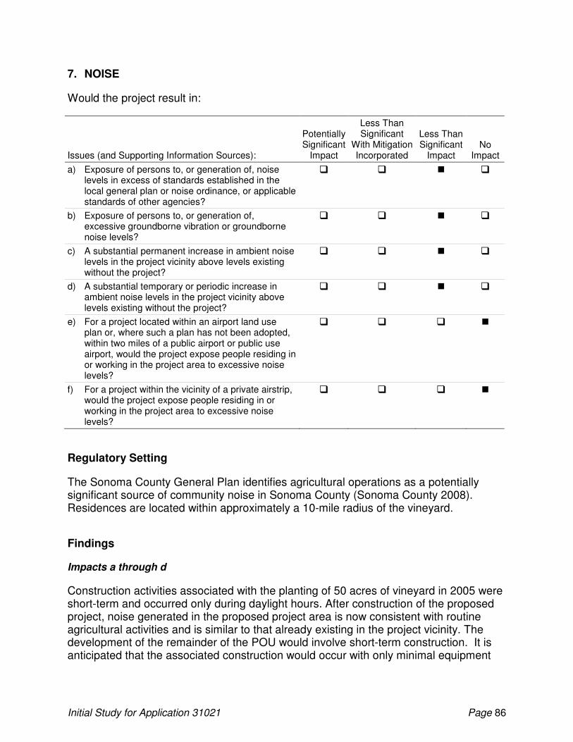
Initial Study for Application 31021 Page 86
7. NOISE
Would the project result in:
Issues (and Supporting Information Sources):
Potentially Significant
Impact
Less Than Significant
With Mitigation Incorporated
Less Than Significant
Impact No
Impact
a) Exposure of persons to, or generation of, noise levels in excess of standards established in the local general plan or noise ordinance, or applicable standards of other agencies?
� � � �
b) Exposure of persons to, or generation of, excessive groundborne vibration or groundborne noise levels?
� � � �
c) A substantial permanent increase in ambient noise levels in the project vicinity above levels existing without the project?
� � � �
d) A substantial temporary or periodic increase in ambient noise levels in the project vicinity above levels existing without the project?
� � � �
e) For a project located within an airport land use plan or, where such a plan has not been adopted, within two miles of a public airport or public use airport, would the project expose people residing in or working in the project area to excessive noise levels?
� � � �
f) For a project within the vicinity of a private airstrip, would the project expose people residing in or working in the project area to excessive noise levels?
� � � �
Regulatory Setting
The Sonoma County General Plan identifies agricultural operations as a potentially significant source of community noise in Sonoma County (Sonoma County 2008). Residences are located within approximately a 10-mile radius of the vineyard.
Findings
Impacts a through d
Construction activities associated with the planting of 50 acres of vineyard in 2005 were short-term and occurred only during daylight hours. After construction of the proposed project, noise generated in the proposed project area is now consistent with routine agricultural activities and is similar to that already existing in the project vicinity. The development of the remainder of the POU would involve short-term construction. It is anticipated that the associated construction would occur with only minimal equipment
Initial Study for Application 31021 Page 87
and machinery and one or two vehicles that will be used to access the site. Impacts a through d were and are considered less than significant.
e. For a project located within an airport land use plan or, where such a plan has not been adopted, within two miles of a public airport or public use airport, would the project expose people residing in or working in the project area to excessive noise levels?
The proposed project area is not located near noise-sensitive areas, within an airport land use plan or where such a plan has not been adopted, or within 2 miles of an airport. Accordingly, there is no impact.
f. For a project within the vicinity of a private airstrip, would the project expose people residing in or working in the project area to excessive noise levels?
The proposed project area is not located within the vicinity of a private airstrip. Accordingly, there is no impact.
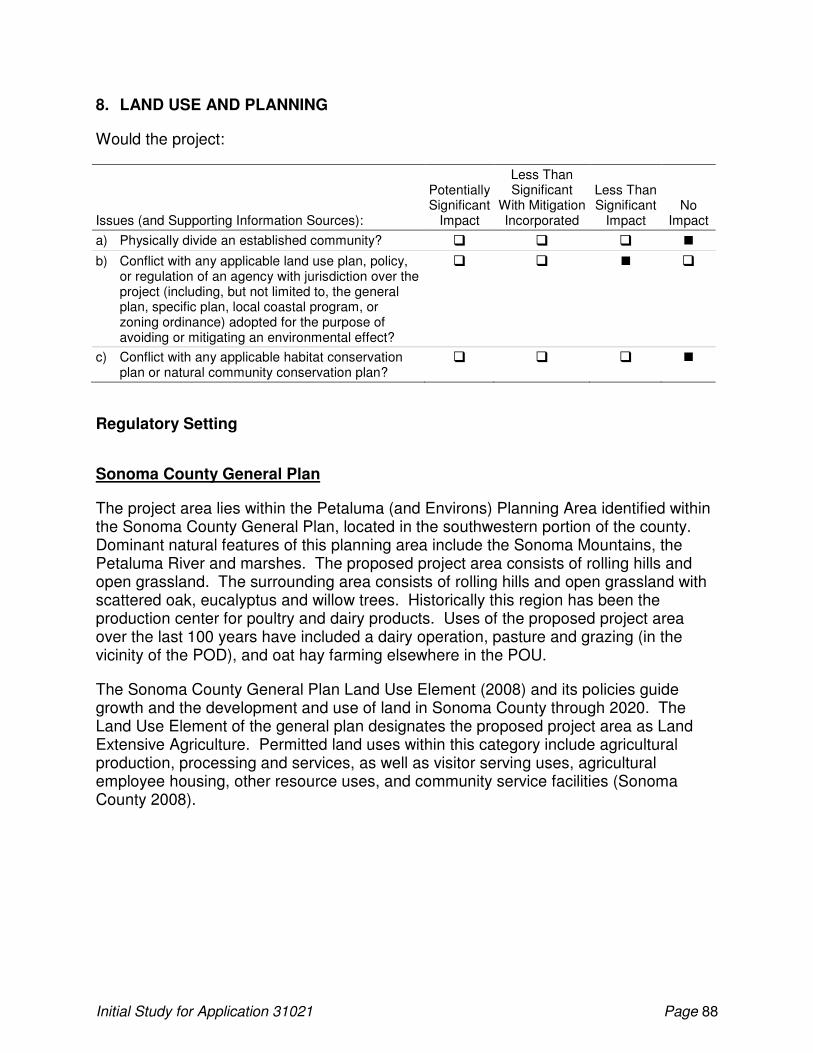
Initial Study for Application 31021 Page 88
8. LAND USE AND PLANNING
Would the project:
Issues (and Supporting Information Sources):
Potentially Significant
Impact
Less Than Significant
With Mitigation Incorporated
Less Than Significant
Impact No
Impact
a) Physically divide an established community? � � � �
b) Conflict with any applicable land use plan, policy, or regulation of an agency with jurisdiction over the project (including, but not limited to, the general plan, specific plan, local coastal program, or zoning ordinance) adopted for the purpose of avoiding or mitigating an environmental effect?
� � � �
c) Conflict with any applicable habitat conservation plan or natural community conservation plan?
� � � �
Regulatory Setting
Sonoma County General Plan
The project area lies within the Petaluma (and Environs) Planning Area identified within the Sonoma County General Plan, located in the southwestern portion of the county. Dominant natural features of this planning area include the Sonoma Mountains, the Petaluma River and marshes. The proposed project area consists of rolling hills and open grassland. The surrounding area consists of rolling hills and open grassland with scattered oak, eucalyptus and willow trees. Historically this region has been the production center for poultry and dairy products. Uses of the proposed project area over the last 100 years have included a dairy operation, pasture and grazing (in the vicinity of the POD), and oat hay farming elsewhere in the POU.
The Sonoma County General Plan Land Use Element (2008) and its policies guide growth and the development and use of land in Sonoma County through 2020. The Land Use Element of the general plan designates the proposed project area as Land Extensive Agriculture. Permitted land uses within this category include agricultural production, processing and services, as well as visitor serving uses, agricultural employee housing, other resource uses, and community service facilities (Sonoma County 2008).
Initial Study for Application 31021 Page 89
The Land Use Element of the general plan provides the following goals and objectives for the protection of agricultural land:
• GOAL LU-9: Protect lands currently in agricultural production and lands with soils and other characteristics, which make them potentially suitable for agricultural use. Retain large parcel sizes and avoid incompatible non-agricultural uses.
� Objective LU-9.1: Avoid conversion of lands currently used for agricultural production to non-agricultural use.
� Objective LU-9.2: Retain large parcels in agricultural production areas and avoid new parcels less than 20 acres in the "Land Intensive Agriculture" category.
� Objective LU-9.3: Agricultural lands not currently used for farming but which have soils or other characteristics which make them suitable for farming shall not be developed in a way that would preclude future agricultural use.
� Objective LU-9.4: Discourage uses in agricultural areas that are not compatible with long-term agricultural production.
� Objective LU-9.5: Support farming by permitting limited small-scale farm services and visitor serving uses in agricultural areas.
Sonoma County Zoning Ordinance
The project area is zoned as a Land Extensive Agriculture District. The Sonoma County Zoning Ordinance (Sonoma County Permit and Resource Management Department 2010) describes the intent of the Land Extensive Agriculture designation as follows:
To enhance and protect lands best suited for permanent agricultural use and capable of relatively low production per acre of land; and to implement the provisions of the land extensive agriculture land use category (Section 2.7.2) of the general plan and the policies of the agricultural resources element.
Uses related to the proposed project that are allowed within the Land Extensive Agriculture designation, which do not require a use permit include raising, feeding, maintaining and breeding of farm animals on parcels exceeding two acres, and growing and harvesting of shrubs, plants, flowers, trees, vines, fruits, vegetables, hay, grain and similar food and fiber crops. Agricultural cultivation without a use permit should maintain the following setbacks:
• Fifty feet from the top of the bank of designated flatland riparian corridors; and
• Twenty-five feet from the top of the bank of designated upland riparian corridors.
Agricultural cultivation may be allowed within the setbacks upon approval of a management plan, which includes appropriate mitigations for potential erosion, bank stabilization and biotic impacts. This plan may be approved by the planning director or by use permit pursuant to Section 26-06-020(a).
Initial Study for Application 31021 Page 90
Sonoma County Tree Protection Ordinance
The Sonoma County Tree Protection Ordinance, Article 88, Section 26-88-010 (m) of the Sonoma County Zoning Ordinance, states that projects should be designed to minimize the destruction of protected trees. The section also states that agricultural cultivation is exempt from this requirement (Sonoma County 1989). The proposed project did not nor does not involve tree removal.
Sonoma County Vineyard Erosion and Sediment Control Ordinance
See the discussion of the Vineyard Erosion and Sediment Control Ordinance in the Geology and Soils section.
Findings
a. Would the project physically divide an established community?
The proposed project did not or would not result in physical barriers that would divide an established community.
b. Would the project conflict with any applicable land use plan, policy, or regulation of an agency with jurisdiction over the project (including, but not limited to, the general plan, specific plan, local coastal program, or zoning ordinance) adopted for the purpose of avoiding or mitigating an environmental effect?
The future development of the proposed POU would include clearing of grassland and grading for reservoir construction and the installation of vineyard irrigation and/or frost protection. As discussed in the Geology and Soils section, the development of the vineyard would occur in areas where soils have a high erosion potential. The areas to be developed have a slope of less than 30 percent. Development of the proposed project would be required to comply with the Sonoma County Vineyard Erosion and Sediment Control Ordinance.
Adherence to the measures contained within the Sonoma County Vineyard Erosion and Sediment Control Ordinance, discussed in the Geology and Soils section above, is expected to reduce potential soil erosion impacts to a less than significant level.
c. Would the project conflict with any applicable habitat conservation plan or natural community conservation plan?
No habitat conservation plans or natural community conservation plans currently exist for the proposed project area.
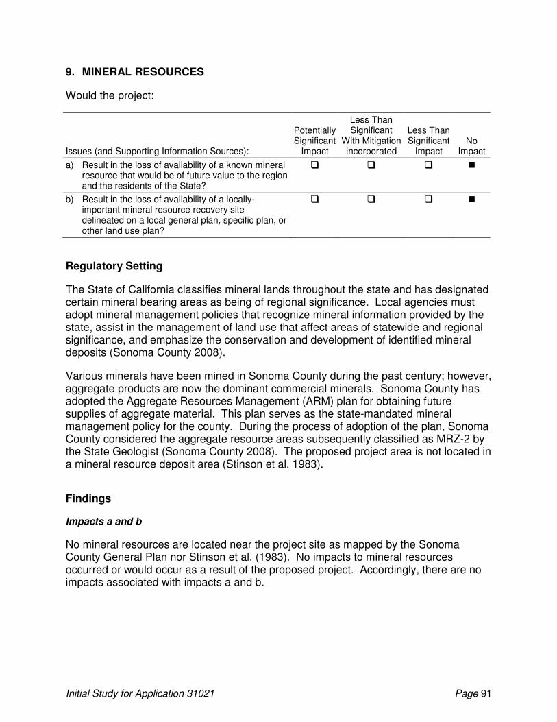
Initial Study for Application 31021 Page 91
9. MINERAL RESOURCES
Would the project:
Issues (and Supporting Information Sources):
Potentially Significant
Impact
Less Than Significant
With Mitigation Incorporated
Less Than Significant
Impact No
Impact
a) Result in the loss of availability of a known mineral resource that would be of future value to the region and the residents of the State?
� � � �
b) Result in the loss of availability of a locally-important mineral resource recovery site delineated on a local general plan, specific plan, or other land use plan?
� � � �
Regulatory Setting
The State of California classifies mineral lands throughout the state and has designated certain mineral bearing areas as being of regional significance. Local agencies must adopt mineral management policies that recognize mineral information provided by the state, assist in the management of land use that affect areas of statewide and regional significance, and emphasize the conservation and development of identified mineral deposits (Sonoma County 2008).
Various minerals have been mined in Sonoma County during the past century; however, aggregate products are now the dominant commercial minerals. Sonoma County has adopted the Aggregate Resources Management (ARM) plan for obtaining future supplies of aggregate material. This plan serves as the state-mandated mineral management policy for the county. During the process of adoption of the plan, Sonoma County considered the aggregate resource areas subsequently classified as MRZ-2 by the State Geologist (Sonoma County 2008). The proposed project area is not located in a mineral resource deposit area (Stinson et al. 1983).
Findings
Impacts a and b
No mineral resources are located near the project site as mapped by the Sonoma County General Plan nor Stinson et al. (1983). No impacts to mineral resources occurred or would occur as a result of the proposed project. Accordingly, there are no impacts associated with impacts a and b.
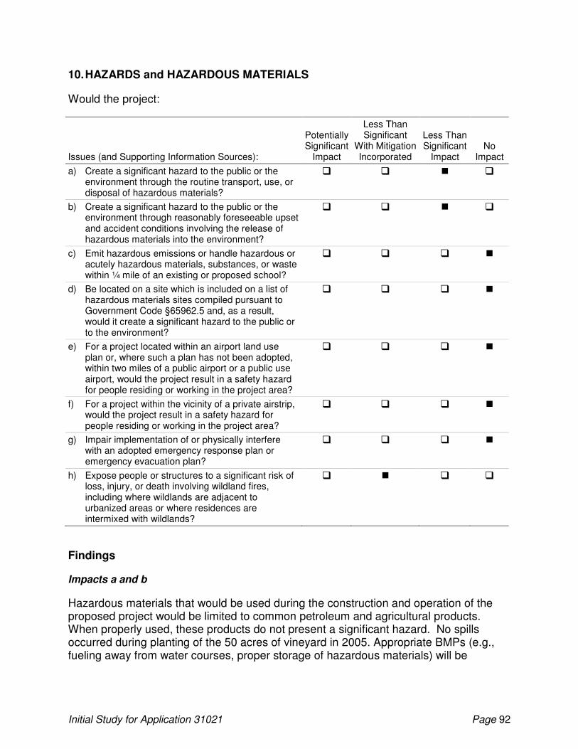
Initial Study for Application 31021 Page 92
10. HAZARDS and HAZARDOUS MATERIALS
Would the project:
Issues (and Supporting Information Sources):
Potentially Significant
Impact
Less Than Significant
With Mitigation Incorporated
Less Than Significant
Impact No
Impact
a) Create a significant hazard to the public or the environment through the routine transport, use, or disposal of hazardous materials?
� � � �
b) Create a significant hazard to the public or the environment through reasonably foreseeable upset and accident conditions involving the release of hazardous materials into the environment?
� � � �
c) Emit hazardous emissions or handle hazardous or acutely hazardous materials, substances, or waste within ¼ mile of an existing or proposed school?
� � � �
d) Be located on a site which is included on a list of hazardous materials sites compiled pursuant to Government Code §65962.5 and, as a result, would it create a significant hazard to the public or to the environment?
� � � �
e) For a project located within an airport land use plan or, where such a plan has not been adopted, within two miles of a public airport or a public use airport, would the project result in a safety hazard for people residing or working in the project area?
� � � �
f) For a project within the vicinity of a private airstrip, would the project result in a safety hazard for people residing or working in the project area?
� � � �
g) Impair implementation of or physically interfere with an adopted emergency response plan or emergency evacuation plan?
� � � �
h) Expose people or structures to a significant risk of loss, injury, or death involving wildland fires, including where wildlands are adjacent to urbanized areas or where residences are intermixed with wildlands?
� � � �
Findings
Impacts a and b
Hazardous materials that would be used during the construction and operation of the proposed project would be limited to common petroleum and agricultural products. When properly used, these products do not present a significant hazard. No spills occurred during planting of the 50 acres of vineyard in 2005. Appropriate BMPs (e.g., fueling away from water courses, proper storage of hazardous materials) will be
Initial Study for Application 31021 Page 93
implemented to prevent a release to the environment during development of the remainder of the POU. Impacts a and b are considered less than significant.
c. Would the project emit hazardous emissions or handle hazardous or acutely hazardous materials, substances, or waste within ¼ mile of an existing or proposed school?
The proposed project is not located within 0.25 mile of any existing or proposed schools. Accordingly, there is no impact.
d. Would the project be located on a site which is included on a list of hazardous materials sites compiled pursuant to Government Code §65962.5 and, as a result, would it create a significant hazard to the public or to the environment?
A search of the U.S Agency for Toxic Substances & Disease Registry (U.S Agency for Toxic Substances & Disease Registry 2011) and the California Department of Toxic Substances Control (California Department of Toxic Substances Control 2007) records did not reveal any known hazardous materials sites within the proposed project area; the proposed project area is not listed pursuant to Government Code §65962.5. However, the Sonoma County Transfer Station disposal facility is located less than a mile away from the proposed project area on Stage Gulch Road. The facility was found in the Solid Waste Information System database as reporting emergency releases into the soil in 1987 (Environmental Data Resources 2003).
e. For a project located within an airport land use plan or, where such a plan has not been adopted, within two miles of a public airport or a public use airport, would the project result in a safety hazard for people residing or working in the project area?
The proposed project is not located within an airport land use plan or where such a plan has not been adopted, or within two miles of a public airport or a public use airport. Accordingly, there is no impact.
f. For a project within the vicinity of a private airstrip, would the project result in a safety hazard for people residing or working in the project area?
The proposed project is not located within the vicinity of a private airstrip. Accordingly, there is no impact.
g. Would the project impair implementation of or physically interfere with an adopted emergency response plan or emergency evacuation plan?
The proposed project did not or does not include features that would interfere with an adopted emergency plan. Accordingly, there is no impact.
h. Would the project expose people or structures to a significant risk of loss, injury, or death involving wildland fires, including where wildlands are adjacent to urbanized areas or where residences are intermixed with wildlands?
Initial Study for Application 31021 Page 94
The proposed project is located in a rural area that contains substantial fuels (e.g., grasses) that are susceptible to wildland fire. Although there was no impact, development of the 50 acres of vineyard in 2005 introduced potential sources of fire. Equipment used during these activities may have created sparks, which could have ignited dry grass or other vegetation in the proposed project area. This risk, which is similar to that found at other rural construction sites, is considered to be a less-than-significant impact if standard safety precautions were taken27. The development of the remainder of the POU would implement BMPs (e.g., clearing construction areas of combustible material, ensuring spark arresters are in good working order and installed on all equipment during project construction, ensuring that adequate fire-fighting tools are on site) during project construction. These actions would reduce to this impact to a less-than-significant level.
27
Standard safety precautions were indeed taken and no fires occurred during the development of the 50 acres of vineyard in 2005.
Initial Study for Application 31021 Page 95
11. POPULATION AND HOUSING
Would the project:
Issues (and Supporting Information Sources):
Potentially Significant
Impact
Less Than Significant
With Mitigation Incorporated
Less Than Significant
Impact No
Impact
a) Induce substantial population growth in an area either directly (e.g., by proposing new homes and businesses) or indirectly (e.g., through extension of roads or other infrastructure)?
� � � �
b) Displace substantial numbers of existing housing, necessitating the construction of replacement housing elsewhere?
� � � �
c) Displace substantial numbers of people, necessitating the construction of replacement housing elsewhere?
� � � �
Findings
Impact a through c
The proposed project did not or would not directly or indirectly induce substantial growth in the project area and would not displace people or housing. The project did not or would not require an expanded permanent workforce that would or will require additional housing in the vicinity of the project. Accordingly, there are no impacts associated with impacts a through c.
Initial Study for Application 31021 Page 96
12. TRANSPORTATION/CIRCULATION
Would the project:
Issues (and Supporting Information Sources):
Potentially Significant
Impact
Less Than Significant
With Mitigation Incorporated
Less Than Significant
Impact No
Impact
a) Cause an increase in traffic that is substantial in relation to the existing traffic load and capacity of the street system (i.e., result in a substantial increase in either the number of vehicle trips, the volume-to-capacity ratio on roads, or congestion at intersections)?
� � � �
b) Substantially increase hazards due to a design feature (e.g., sharp curves or dangerous intersections) or incompatible uses (e.g., farm equipment)?
� � � �
c) Result in inadequate emergency access? � � � �
d) Result in inadequate parking capacity? � � � �
e) Exceed, either individually or cumulatively, a level-of-service standard established by the county congestion management agency for designated roads or highways?
� � � �
f) Conflict with adopted policies supporting alternative transportation (e.g., bus turnouts, bicycle racks)?
� � � �
g) Result in a change in air traffic patterns, including either an increase in traffic levels or a change in location that results in substantial safety risks?
� � � �
Findings
a. Would the project cause an increase in traffic that is substantial in relation to the existing traffic load and capacity of the street system (i.e., result in a substantial increase in either the number of vehicle trips, the volume-to-capacity ratio on roads, or congestion at intersections)?
Vehicular access to the proposed project area is provided by Stage Gulch Road, a two-lane road that is part of State Route 116 in southern Sonoma County. Development of the 50 acres of vineyard in 2005 caused a temporary and negligible increase in traffic as laborers and materials were transported to and from the project area. This increase was slight and did not represent a significant impact on transportation or circulation. This impact is considered less than significant.
A negligible increase in traffic is anticipated from the development of the remainder of the POU. The increased traffic would primarily be temporary, caused mainly by construction crews and transportation of materials to and from the construction areas.
Initial Study for Application 31021 Page 97
This increase is expected to be slight and would not represent a significant impact to transportation or circulation.
Impacts b through g
No substantial new impediments to emergency access or incompatible uses occurred, and the project did not result in inadequate parking capacity or conflict with adopted alternative transportation policies, plans, or programs. Impacts on transportation and circulation resulting from the development of the remainder of the POU would be similar than the impacts caused by development of the 50 acres of vineyard in 2005 and are not discussed further. There are no impacts associated with impacts b through g.
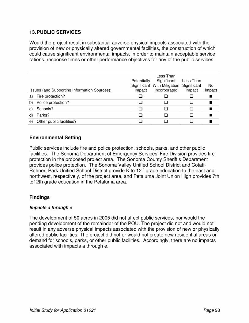
Initial Study for Application 31021 Page 98
13. PUBLIC SERVICES
Would the project result in substantial adverse physical impacts associated with the provision of new or physically altered governmental facilities, the construction of which could cause significant environmental impacts, in order to maintain acceptable service rations, response times or other performance objectives for any of the public services:
Issues (and Supporting Information Sources):
Potentially Significant
Impact
Less Than Significant
With Mitigation Incorporated
Less Than Significant
Impact No
Impact
a) Fire protection? � � � �
b) Police protection? � � � �
c) Schools? � � � �
d) Parks? � � � �
e) Other public facilities? � � � �
Environmental Setting
Public services include fire and police protection, schools, parks, and other public facilities. The Sonoma Department of Emergency Services’ Fire Division provides fire protection in the proposed project area. The Sonoma County Sheriff’s Department provides police protection. The Sonoma Valley Unified School District and Cotati-Rohnert Park Unified School District provide K to 12th grade education to the east and northwest, respectively, of the project area, and Petaluma Joint Union High provides 7th to12th grade education in the Petaluma area.
Findings
Impacts a through e
The development of 50 acres in 2005 did not affect public services, nor would the pending development of the remainder of the POU. The project did not and would not result in any adverse physical impacts associated with the provision of new or physically altered public facilities. The project did not or would not create new residential areas or demand for schools, parks, or other public facilities. Accordingly, there are no impacts associated with impacts a through e.
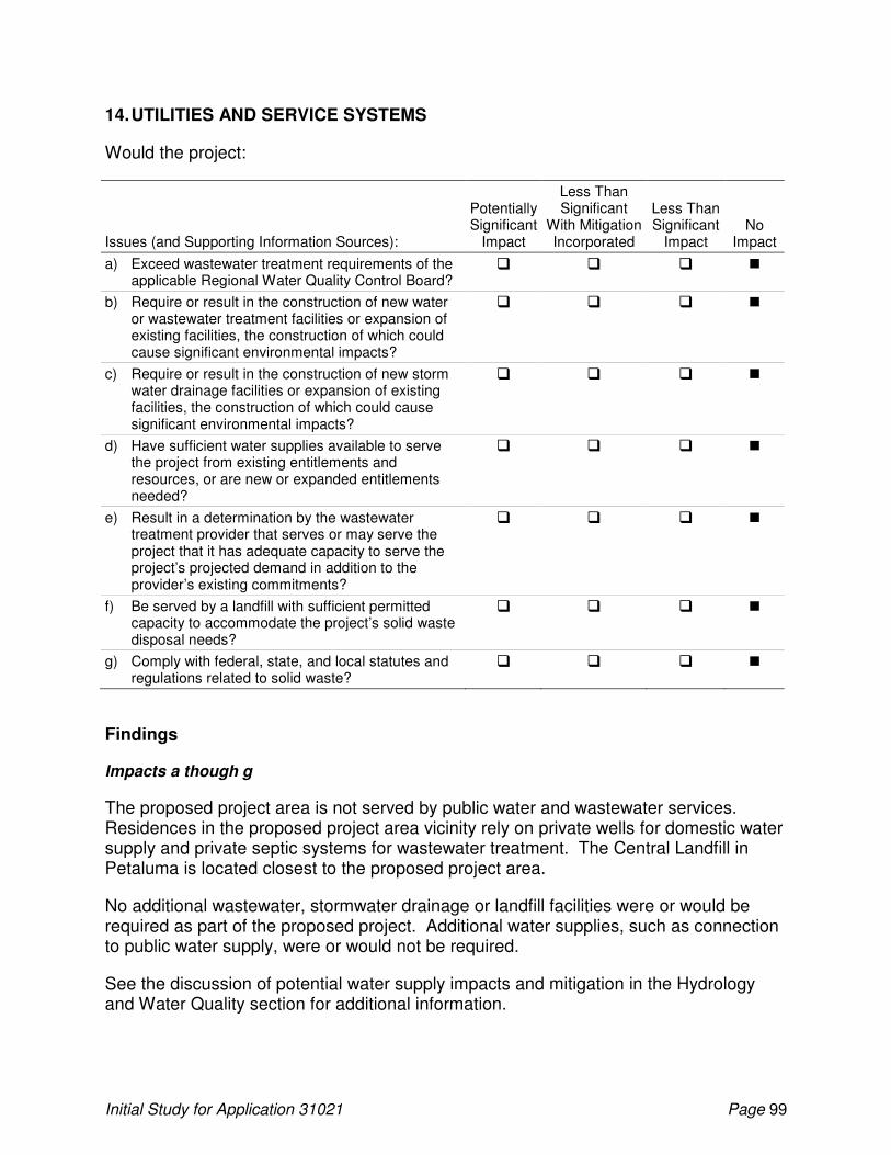
Initial Study for Application 31021 Page 99
14. UTILITIES AND SERVICE SYSTEMS
Would the project:
Issues (and Supporting Information Sources):
Potentially Significant
Impact
Less Than Significant
With Mitigation Incorporated
Less Than Significant
Impact No
Impact
a) Exceed wastewater treatment requirements of the applicable Regional Water Quality Control Board?
� � � �
b) Require or result in the construction of new water or wastewater treatment facilities or expansion of existing facilities, the construction of which could cause significant environmental impacts?
� � � �
c) Require or result in the construction of new storm water drainage facilities or expansion of existing facilities, the construction of which could cause significant environmental impacts?
� � � �
d) Have sufficient water supplies available to serve the project from existing entitlements and resources, or are new or expanded entitlements needed?
� � � �
e) Result in a determination by the wastewater treatment provider that serves or may serve the project that it has adequate capacity to serve the project’s projected demand in addition to the provider’s existing commitments?
� � � �
f) Be served by a landfill with sufficient permitted capacity to accommodate the project’s solid waste disposal needs?
� � � �
g) Comply with federal, state, and local statutes and regulations related to solid waste?
� � � �
Findings
Impacts a though g
The proposed project area is not served by public water and wastewater services. Residences in the proposed project area vicinity rely on private wells for domestic water supply and private septic systems for wastewater treatment. The Central Landfill in Petaluma is located closest to the proposed project area.
No additional wastewater, stormwater drainage or landfill facilities were or would be required as part of the proposed project. Additional water supplies, such as connection to public water supply, were or would not be required.
See the discussion of potential water supply impacts and mitigation in the Hydrology and Water Quality section for additional information.

Initial Study for Application 31021 Page 100
15. AESTHETICS
Would the project:
Issues (and Supporting Information Sources):
Potentially Significant
Impact
Less Than Significant
With Mitigation Incorporated
Less Than Significant
Impact No
Impact
a) Have a substantial adverse effect on a scenic vista?
� � � �
b) Substantially damage scenic resources, including, but not limited to, trees, rock outcroppings, and historic buildings within a state scenic highway?
� � � �
c) Substantially degrade the existing visual character or quality of the site and its surroundings?
� � � �
d) Create a new source of substantial light or glare that would adversely affect day or nighttime views in the area?
� � � �
Findings
Impacts a and b
The proposed project area contains scenic resources characteristic of Sonoma County in general, including mountainous landscapes, agricultural and pastoral settings, and riparian areas. The existing agricultural use of the proposed project area is consistent with the rural aesthetic quality of the region, and there were no impacts with respect to adverse effects on a scenic vista or substantial damages to scenic resources as a result of the development of 50 acres of vineyard in 2005. The pending development of the remainder of the POU would not result in adverse effects on a scenic vista or damage to scenic resources or degrade the visual character of the site..
c. Would the project substantially degrade the existing visual character or quality of the site and its surroundings?
While the development of 50 acres of vineyard in 2005 may have degraded the existing visual character of the proposed project area, that use is consistent with the rural aesthetic quality of the region, and impacts are less than significant. Furthermore, the pending development of the remainder of the POU would not degrade the existing visual character of the proposed project area and its surroundings. Impacts are considered less than significant.
d. Would the project create a new source of substantial light or glare that would adversely affect day or nighttime views in the area?
Neither the development of 50 acres of vineyard in 2005 nor the pending development of the remainder of the POU introduced or would introduce a new source of substantial light or glare. Accordingly, there is no impact.

Initial Study for Application 31021 Page 101
16. CULTURAL RESOURCES
Would the project:
Issues (and Supporting Information Sources):
Potentially Significant
Impact
Less Than Significant
With Mitigation Incorporated
Less Than Significant
Impact No
Impact
a) Cause a substantial adverse change in the significance of a historical resource as defined in §15064.5?
� � � �
b) Cause a substantial adverse change in the significance of an archaeological resource as defined in §15064.5?
� � � �
c) Directly or indirectly destroy a unique paleontological resource or site or unique geologic feature?
� � � �
d) Disturb any human remains, including those interred outside of formal cemeteries?
� � � �
Environmental Setting
Archaeological Resource Services (ARS) conducted a cultural resources study of the proposed project area in 2000. The cultural resources study included background research at the Northwest Information Center (NWIC) of the California Historical Resources Information System at Sonoma State University and a field survey of the proposed project area. ICF Jones & Stokes conducted consultation with the Native American Heritage Commission (NAHC) and local Native American representatives in 2007. Information obtained as a result of the literature review is presented in the prehistoric, ethnographic, and historic context summaries of this section.
A records search of the proposed project area was conducted at the NWIC at Sonoma State University. The research revealed that a portion of the property had been previously surveyed and indicated that an unrecorded midden site and multiple previously recorded sites have been found in the project area vicinity. The proposed project is situated within an area of Sonoma County that is known to have high sensitivity for cultural resources, including the adjacent Tolay Lake basin. A cultural resources survey of the proposed project area and a report detailing the survey results were completed August 2000 (Archaeological Resource Service 2000).
Based on the field survey, one prehistoric archaeological site, one historic ranch complex, and a few isolated prehistoric artifacts were located in or adjacent to the proposed project area. Prehistoric site Ca-Son-2310 was found to be located within the project area. The project area was subsequently modified, and the acreage in the POU was decreased to insure Ca-Son-2310 was not located within the project boundaries. In order to further reduce the possibility of any project related impacts to Ca-Son-2310, a

Initial Study for Application 31021 Page 102
200-foot buffer was incorporated into the project area boundary28. The ranch complex (P-49-002766) is within the project area near the drainage divide between the Champlin Creek and Tolay Creek watersheds (Figure 2). The ranch complex is not within the location of the proposed reservoir or vineyards and would not be affected by any ground disturbing activities resulting from project implementation. All rock outcrops were inspected for the presence of prehistoric petroglyphs or mortar depressions though none were noted. A cobble concentration and a chert flake were found in the southwestern portion of the proposed project area. The location of the proposed reservoir would be located adjacent to a steep seasonal swale.
Consultation with the NAHC and local Native American representatives was conducted by ICF Jones & Stokes in 2007. The NAHC conducted a search of their sacred lands database for any potential cultural resources within the project area including Traditional Cultural Properties. The search of the sacred sites files did not indicate the recordation of any sacred sites. However, the NAHC provided a list of local Native American representatives that may have knowledge of, or concerns about, cultural resources within the project area. As a result of this, the Federated Indians of Graton Rancheria (FIGR) requested a meeting with ICF Jones & Stokes and the Division. FIGR representatives expressed concern about project impacts on Ca-Son-2310 and had additional concerns with the proximity of the project to the historic Tolay Lake basin. To date, no other responses have been received from Native American representatives on the NAHC contact list.
On April 7, 2009, a meeting with the Division, FIGR, ICF Jones & Stokes, and the landowner was held at the proposed project area. The FIGR representative expressed additional concerns with development of the southwestern portion of the proposed POU since it is adjacent to the Tolay Lake basin. Additional concerns were articulated in electronic correspondence with the FIGR representative. These concerns related to the ground disturbing activities associated with construction of the reservoir and installation of pipelines that convey the water to the vineyard area. The landowner agreed to fund a Native American monitor during the deep ripping phase of the installation of the 19-acres of vineyard delineated after a field visit between all parties to address this matter (Figure 5). It was noted during the cultural resource survey of the property, and in the course of the field visit that there are no rock outcrops for mortars or petroglyphs and that the intermittent drainage on which the POD is proposed is not conducive to the location of habitation/archeological sites. It was also observed that the proposed reservoir location and pipelines are distant enough from the historic lake basin as to not warrant additional monitoring.
The seasonal wetland areas (“H”, “G”, and “F” on Figure 2) are not likely areas for prehistoric habitation, although these places have the potential for isolated artifacts associated with gathering and processing of plant materials (Archaeological Resource Service 2000). Furthermore, as discussed previously, wetland areas would be avoided.
28
Prehistoric site Ca-Son-2310 currently has a much larger buffer than 200 feet because the entire eastern portion of the POU will be preserved as wetland habitat. Refer to the discussion in the Biological Resources section for additional information.
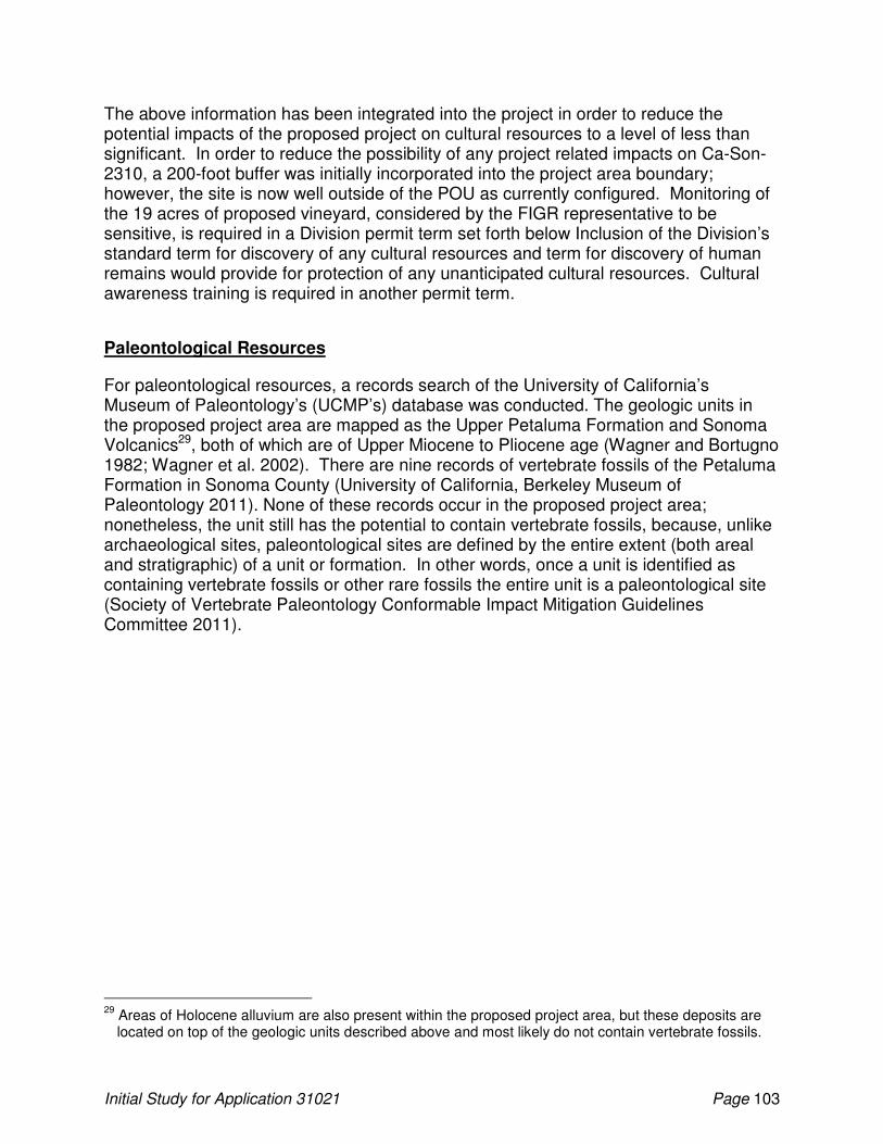
Initial Study for Application 31021 Page 103
The above information has been integrated into the project in order to reduce the potential impacts of the proposed project on cultural resources to a level of less than significant. In order to reduce the possibility of any project related impacts on Ca-Son-2310, a 200-foot buffer was initially incorporated into the project area boundary; however, the site is now well outside of the POU as currently configured. Monitoring of the 19 acres of proposed vineyard, considered by the FIGR representative to be sensitive, is required in a Division permit term set forth below Inclusion of the Division’s standard term for discovery of any cultural resources and term for discovery of human remains would provide for protection of any unanticipated cultural resources. Cultural awareness training is required in another permit term.
Paleontological Resources
For paleontological resources, a records search of the University of California’s Museum of Paleontology’s (UCMP’s) database was conducted. The geologic units in the proposed project area are mapped as the Upper Petaluma Formation and Sonoma Volcanics29, both of which are of Upper Miocene to Pliocene age (Wagner and Bortugno 1982; Wagner et al. 2002). There are nine records of vertebrate fossils of the Petaluma Formation in Sonoma County (University of California, Berkeley Museum of Paleontology 2011). None of these records occur in the proposed project area; nonetheless, the unit still has the potential to contain vertebrate fossils, because, unlike archaeological sites, paleontological sites are defined by the entire extent (both areal and stratigraphic) of a unit or formation. In other words, once a unit is identified as containing vertebrate fossils or other rare fossils the entire unit is a paleontological site (Society of Vertebrate Paleontology Conformable Impact Mitigation Guidelines Committee 2011).
29
Areas of Holocene alluvium are also present within the proposed project area, but these deposits are located on top of the geologic units described above and most likely do not contain vertebrate fossils.

Initial Study for Application 31021 Page 104
Figure 5 Martinelli Ranch Project Area and Vineyard
Initial Study for Application 31021 Page 105
Findings
Impacts a and b
No significant historical resources will be impacted by the project as it is currently proposed in Application 31021; however, to address concerns identified by FIGR the following terms will be included in any permits or licenses issued pursuant to Application 31021:
• Prior to construction activities, permittee shall provide personnel whose qualifications are acceptable to the Deputy Director for Water Rights, to conduct a cultural awareness training session for the individuals causing, directing or responsible for earth disturbing activities. The training shall include artifact recognition and protocol for inadvertent discovery of archaeological materials. The training session shall take place within one to two weeks of the commencement of ground disturbing activities associated with the reservoir construction or any areas of vineyard installation. A local Native American designated by Federated Indians of Graton Rancheria will be given the opportunity to attend the training session to explain the tribe’s concerns. Permittee shall provide a 30 day advance notice to the Deputy Director for Water Rights and Federated Indians of Graton Rancheria prior to conducting the training session. A roster will be taken confirming individuals who attend the session.
• Permittee shall retain a Native American monitor to be designated by the Federate Indians of Graton Rancheria to monitor deep ripping of 19 acres delineated on Figure 5 prior to ground preparation of the vineyard in the southwestern portion of the project area. Permittee shall submit evidence satisfactory to the Deputy Director for Water Rights documenting the monitor has been retained at least 30 days before commencement of activities associated with ground preparation for vineyard development. Permittee shall also submit evidence satisfactory to the Deputy Director for Water Rights documenting that monitoring has occurred prior to planting the 19 acre vineyard area. This evidence shall include copies of the daily monitoring report or an invoice provided to the Applicant by a Federated Indians of Graton Rancheria representative.
There is the possibility that buried archeological deposits could be present and accidental discovery could occur, particularly in the area immediately adjacent to the Tolay Lake basin. The following permit term, substantially as written, pursuant to CEQA Guidelines 15064.5 (f), “provisions for historical or unique archaeological resources accidentally discovered during construction”, will be included in any permits or licenses issued pursuant to Application 31021:
• Should any buried archeological materials be uncovered during project activities, such activities shall cease within 100 feet of the find. Prehistoric archeological indicators include: obsidian and chert flakes and chipped stone tools; bedrock outcrops and boulders with mortar cups; ground stone implements (grinding
Initial Study for Application 31021 Page 106
slabs, mortars and pestles) and locally darkened midden soils containing some of the previously listed items plus fragments of bone and fire affected stones. Historic period site indicators generally include: fragments of glass, ceramic and metal objects; milled and split lumber; and structure and feature remains such as building foundations, privy pits, wells and dumps; and old trails. The Deputy Director for Water Rights shall be notified of the discovery and a professional archeologist shall be retained by the permittee to evaluate the find and recommend appropriate mitigation measures. Proposed mitigation measures shall be submitted to the Deputy Director for Water Rights for approval. Project-related activities shall not resume within 100 feet of the find until all approved mitigation measures have been completed to the satisfaction of the Deputy Director for Water Rights.
c. Would the project directly or indirectly destroy a unique paleontological resource or site or unique geologic feature?
Paleontological resources could be present in the proposed project area because the Petaluma Formation is known to contain vertebrate fossils. Damage or destruction of vertebrate paleontological resources would constitute a significant impact. Implementation of the permit term below would reduce this impact to a less-than-significant level.
• If vertebrate fossils are discovered during project activities, all work shall cease within 100 feet of the find until a qualified professional paleontologist as defined by the Society of Vertebrate Paleontology’s Conformable Impact Mitigation Guidelines Committee (2011) can assess the nature and importance of the find and recommend appropriate treatment. The Division will also be notified of the discovery and the qualified professional paleontologist’s opinion within 48 hours of the initial finding. Treatment may include preparation and recovery of fossil materials, so that they can be housed in an appropriate museum or university collection, and also may include preparation of a report for publication describing the finds. Project activities shall not resume until after the qualified professional paleontologist has given clearance and evidence of such clearance has been submitted do the Division.
d. Would the project disturb any human remains, including those interred outside of formal cemeteries?
If any discovery includes human remains, CEQA Guidelines 15064.5 (e)(1) and California Health and Safety Code section 7050.5 shall be followed. Consultation with a local coroner and Native Americans shall occur. The county coroner is required to examine all discoveries of human remains within 48 hours of the notification. To address this issue, a permit term, substantially as follows, shall be included in any permit or license issued pursuant to Application 31021:
• If human remains are encountered, then the permittee shall comply with section 15064.5 (e) (1) of the California Environmental Quality Act Guidelines and the Health and Safety Code section 7050.5. All project-related ground disturbance
Initial Study for Application 31021 Page 107
within 100 feet of the find shall be halted until the county coroner has been notified. If the coroner determines that the remains are Native American, the coroner will notify the Native American Heritage Commission within 24 hours. The Native American Heritage Commission will identify the person or persons believed to be the most likely descendants from the deceased Native American. The most likely descendent may make recommendations regarding the means of treating or disposing of the remains with appropriate dignity. Project-related ground disturbance in the vicinity of the find shall not resume until the process detailed under section 15064.5 (e) has been completed and evidence of completion has been submitted to the Deputy Director for Water Rights.
Copies of the cultural resource report and the site records are confidential information not subject to the Freedom of Information Act, therefore, those items are on file in the Division of Water Rights cultural resource files (California Government Code section 6254.10).

Initial Study for Application 31021 Page 108
17. RECREATION
Would the project:
Issues (and Supporting Information Sources):
Potentially Significant
Impact
Less Than Significant
With Mitigation Incorporated
Less Than Significant
Impact No
Impact
a) Increase the use of existing neighborhood and regional parks or other recreational facilities such that substantial physical deterioration of the facility would occur or be accelerated?
� � � �
b) Include recreational facilities or require the construction or expansion of recreational facilities that might have an adverse physical effect on the environment?
� � � �
Environmental Setting
Sonoma County has various types of parklands, including federal recreation areas and state parks, regional parks, community parks and neighborhood parks. Recreational opportunities include fishing, camping, swimming, picnicking, horseback riding, bicycling, hiking or walking.
Findings
Impacts a and b
Neither the development of 50 acres of vineyard in 2005 nor the pending development of the remainder of the POU increased or would increase the use of existing neighborhood and regional parks or other recreational facilities such that substantial physical deterioration of the facility would occur or be accelerated. Past and proposed project activities do not include recreation facilities or require the construction or expansion of recreational facilities that might have an adverse physical effect on the environment.
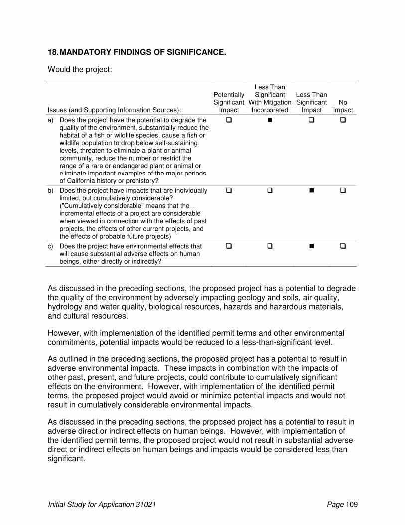
Initial Study for Application 31021 Page 109
18. MANDATORY FINDINGS OF SIGNIFICANCE.
Would the project:
Issues (and Supporting Information Sources):
Potentially Significant
Impact
Less Than Significant
With Mitigation Incorporated
Less Than Significant
Impact No
Impact
a) Does the project have the potential to degrade the quality of the environment, substantially reduce the habitat of a fish or wildlife species, cause a fish or wildlife population to drop below self-sustaining levels, threaten to eliminate a plant or animal community, reduce the number or restrict the range of a rare or endangered plant or animal or eliminate important examples of the major periods of California history or prehistory?
� � � �
b) Does the project have impacts that are individually limited, but cumulatively considerable? ("Cumulatively considerable" means that the incremental effects of a project are considerable when viewed in connection with the effects of past projects, the effects of other current projects, and the effects of probable future projects)
� � � �
c) Does the project have environmental effects that will cause substantial adverse effects on human beings, either directly or indirectly?
� � � �
As discussed in the preceding sections, the proposed project has a potential to degrade the quality of the environment by adversely impacting geology and soils, air quality, hydrology and water quality, biological resources, hazards and hazardous materials, and cultural resources.
However, with implementation of the identified permit terms and other environmental commitments, potential impacts would be reduced to a less-than-significant level.
As outlined in the preceding sections, the proposed project has a potential to result in adverse environmental impacts. These impacts in combination with the impacts of other past, present, and future projects, could contribute to cumulatively significant effects on the environment. However, with implementation of the identified permit terms, the proposed project would avoid or minimize potential impacts and would not result in cumulatively considerable environmental impacts.
As discussed in the preceding sections, the proposed project has a potential to result in adverse direct or indirect effects on human beings. However, with implementation of the identified permit terms, the proposed project would not result in substantial adverse direct or indirect effects on human beings and impacts would be considered less than significant.
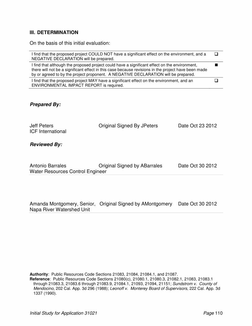
Initial Study for Application 31021 Page 110
III. DETERMINATION
On the basis of this initial evaluation:
I find that the proposed project COULD NOT have a significant effect on the environment, and a NEGATIVE DECLARATION will be prepared.
�
I find that although the proposed project could have a significant effect on the environment, there will not be a significant effect in this case because revisions in the project have been made by or agreed to by the project proponent. A NEGATIVE DECLARATION will be prepared.
�
I find that the proposed project MAY have a significant effect on the environment, and an ENVIRONMENTAL IMPACT REPORT is required.
�
Prepared By:
Jeff Peters Original Signed By JPeters Date Oct 23 2012 ICF International
Reviewed By:
Antonio Barrales Original Signed by ABarrales Date Oct 30 2012 Water Resources Control Engineer
Amanda Montgomery, Senior, Original Signed by AMontgomery Date Oct 30 2012 Napa River Watershed Unit
Authority: Public Resources Code Sections 21083, 21084, 21084.1, and 21087. Reference: Public Resources Code Sections 21080(c), 21080.1, 21080.3, 21082.1, 21083, 21083.1
through 21083.3, 21083.6 through 21083.9, 21084.1, 21093, 21094, 21151; Sundstrom v. County of Mendocino, 202 Cal. App. 3d 296 (1988); Leonoff v. Monterey Board of Supervisors, 222 Cal. App. 3d 1337 (1990).

Initial Study for Application 31021 Page 111
Information Sources
Archaeological Resource Service. 2000. A Cultural Resources Evaluation of the Martinelli Ranch, Water Rights Application 31021, Champlin Creek, Sonoma County, California. August 28. Petaluma, CA. On File at the Division of Water Rights, State Water Resources Control Board.
Armor, Charles. Regional Manager. California Department of Fish and Game, Bay Delta Region—Memorandum: Registration of a Livestock Stockpond Use Appropriation by Mr. David Martinelli from an Unnamed Swale, Tributary to an Unnamed Stream, Tributary to Tolay Creek, Thence San Pablo Bay, Petaluma, Sonoma County. November 9, 2007. In File for Application 31021, Division of Water Rights, State Water Resources Control Board.
Bay Area Air Quality Management District. 1999. Bay Area Air Quality Management District CEQA Guidelines: Assessing the Air Quality Impacts of Projects and Plans. San Francisco, California.
Becker, Gordon. Senior Fisheries Scientist. Center for Ecosystem Management and Restoration, Oakland, CA. December 9–10, 2009—email exchange with Jeff Peters, ICF Jones & Stokes, about the occurrence of steelhead in Champlin Creek. In File for Application 31021, Division of Water Rights, State Water Resources Control Board.
California Air Resources Board. 2008a. Area Designation Maps. Available: <http://www.arb.ca.gov/desig/adm/adm.htm>. Last posted or revised: September 11, 2007. Accessed: July 17, 2008.
California Air Resources Board. 2008b. Ambient Air Quality Standards. Available: <http://www.arb.ca.gov/aqs/aaqs2.pdf>. Last posted or revised: May 18, 2006. Accessed: July 17, 2008.
California Air Resources Board. 2008c. Air Quality Data Statistics. Available: <http://www.arb.ca.gov/adam/welcome.html>. Last posted or revised: Unknown. Accessed: July 17, 2008.
California Department of Conservation, Office of Land Conservation. 1997. California Agricultural Land Evaluation and Site Assessment Model. Available: <http://www.consrv.ca.gov/dlrp/LESA/lesamodl.pdf>. Last posted or revised: 2007. Accessed: January 6, 2011.
California Department of Fish and Game. 1983. Guidelines for assessing the effects of proposed projects on rare, threatened, and endangered plants and natural communities. December 9, 1983. Revised May 8, 2000. 2 pps.
California Department of Fish and Game. 1995. Staff Report on Burrowing Owl Mitigation. October 17, 1995. California Department of Fish and Game Environmental Services Division. Sacramento, CA.
Initial Study for Application 31021 Page 112
California Department of Fish and Game. 2001. Letter: Requesting surveys to comply with the California Environmental Quality Act review of water rights applications. Addressed to State Water Resources Control Board. April 23, 2001. In File for Application 31021, Division of Water Rights, State Water Resources Control Board.
California Department of Fish and Game. 2004. Letter: Requested Additions to the Points of Interest (POIs) for Water Application (WA) 31021 of Martinelli Ranch to Appropriate Water From an Unnamed Stream Tributary to Champlin Creek, Thence Rodgers Creek, Thence Fowler Creek, Thence Sonoma Creek in Sonoma County. Addressed to State Water Resources Control Board. June 30, 2004. In File for Application 31021, Division of Water Rights, State Water Resources Control Board.
California Department of Fish and Game. 2008. Life History Accounts and Range Maps – California Wildlife Habitat Relationship System. Biogeographic Data Branch. Sacramento, CA. Available:<http://www.dfg.ca.gov/whab.html/cawildlife.html>. Last posted or revised: 2008. Accessed: December 8, 2008.
California Department of Fish and Game and the National Marine Fisheries Service. 2002. Draft Guidelines for Maintaining Instream Flows to Protect Fisheries Resources Downstream of Water Diversions in Mid-California Coastal Streams. June 17, 2002.
California Department of Toxic Substances Control. 2007. ENVIROSTOR Project Search Results. Available: <http:// http://www.envirostor.dtsc.ca.gov/public/>. Last posted or revised: 2007. Accessed: June 21, 2011.
California Division of Mines and Geology. 1980. Geology for planning in Sonoma County. Special Report 120. Sacramento, CA.
California Division of Mines and Geology. 1997. Guidelines for evaluating and mitigating seismic hazards in California. California Division of Mines and Geology Special Publication 117. Sacramento, CA.
California Division of Mines and Geology. 2001. Digital images of official maps of the Alquist-Priolo earthquake fault zones of California, Central Coastal Region, California. Sonoma County. Available: <http://www.lib.berkeley.edu/EART/UCONLY/CDMG/central/coast_index.pdf>. Last posted or revised: November 14, 2010. Accessed: December 31, 2010.
California Geological Survey. 2007a. Special Publication 42, Fault-Rupture Hazard Zones in California, Interim Revision, August, 2007.
California Geologic Survey. 2007b. Seismic Shaking Hazards in California. Available: <http://www.consrv.ca.gov/CGS/rghm/pshamap/pshamain.html>. Last posted or revised: December 10, 2010. Accessed: December 31, 2010.
Initial Study for Application 31021 Page 113
Cao, T., W. A. Bryant, B. Rowshandel, D. Branum, and C. J. Wills. 2003. The Revised 2002 California Probabilistic Seismic Hazard Maps. Available: <http://www.consrv.ca.gov/CGS/rghm/psha/fault_parameters/pdf/2002_CA_Hazard_Maps.pdf>. Last posted or revised: May 4, 2005. Accessed: January 19, 2011.
CalFish. 2009. CalFish Geographic Data, CalFish Map Query. Available at: <http://www.calfish.org/DataandMaps/CalFishGeographicData/tabid/91/Default.aspx>. Last posted or revised: 2009. Accessed: December 29, 2009.
California Natural Diversity Database. 2008. Search of Counties for Special Status Species. Sacramento, CA : California Department of Fish and Game.
Center for Ecosystem Management and Restoration. 2005. Historical Distribution and Current Status of Steelhead (Oncorhynchus mykiss) in Streams of the San Francisco Estuary, California. Available at: <http://www.cemar.org/estuarystreamsreport/homepage.html>. Last posted or revised: Unknown. Accessed: December 29, 2009.
Cox, Bill. Fisheries Biologist. California Department of Fish and Game, Yountville, CA. December 11–12, 2003—telephone conversation with Donna Maniscalco, Jones & Stokes, about the occurrence of Chinook salmon, steelhead, and California freshwater shrimp in Sonoma Creek, Fowler Creek, Rodgers Creek, and Champlin Creek. In File for Application 31021, Division of Water Rights, State Water Resources Control Board.
Environmental Data Resources. 2003. The EDR Radius Map with GeoCheck for Stage Gulch Ranch.
Erickson Engineering. 2008. Proposed Compliance Plan for Flow Bypass Terms. In File for Application 31021, Division of Water Rights, State Water Resources Control Board.
Fellers, Gary M. and Patrick M. Kleeman. 2007. California red-legged Frog (Rana draytonii) Movement and Habitat Use: Implications for Conservation. Journal of Herpetology: 41(2): 276-286.
Gray, Corinne. Water Rights Coordinator. California Department of Fish and Game, Yountville, CA. February 20, 2011—email exchange with Jeffrey Peters, ICF International, about the need to resurvey for California red-legged frog in the Martinelli Ranch drainages in 2011. In File for Application 31021, Division of Water Rights, State Water Resources Control Board.
Hart, E.W. and W.A. Bryant. 1997. Fault-rupture hazard zones in California: Alquist-Priolo Earthquake Fault Zoning Act with index to earthquake fault zone maps. Special Publication 42. California Division of Mines and Geology. Sacramento, CA.
Initial Study for Application 31021 Page 114
Hearn, William. Fisheries Scientist. National Marine Fisheries Service, Santa Rosa, CA. January 13, 2006—email exchange with Eric Oppenheimer, Division of Water Rights, State Water Resources Control Board, about the lack of need to perform additional hydrological analysis on steelhead-only streams when the CFII value is between 5 and 10%. On File with the Division of Water Rights, State Water Resources Control Board.
ICF Jones & Stokes. 2010. Martinelli Ranch (Application 31021) - Stream Classification and Upstream Limit of Anadromy Assessment of Unnamed Stream Tributary to Champlin Creek, thence Champlin Creek, thence Rodgers Creek, thence Fowler Creek, thence Sonoma Creek, thence San Pablo Bay, Sonoma County (December 17, 2009) (Final Version). June 28, 2010. Sacramento, CA. In File for Application 31021, Division of Water Rights, State Water Resources Control Board.
International Conference of Building Officials. 1997. Maps of Known Active Fault Near-Source Zones in California and Adjacent Portions of Nevada to Be Used with 1997 Uniform Building Code. Whittier, CA: International Conference of Building Officials.
Jennings, C.W. and W.A. Bryant. 2010. Fault activity map of California: California Geological Survey Geologic Data Map No. 6. Map scale 1:750,000.
Jennings, M.R. and M. Hayes. 1994. Amphibian and Reptile Species of Special Concern in California. California Department of Fish and Game. Sacramento, CA.
Jones & Stokes. 2006. Letter Report: Final Revision of Water Availability Analysis and Cumulative Flow Impairment Index Report, Water Rights Application A31021 (Martinelli Ranch). December 6. Sacramento, CA. In File for Application 31021, Division of Water Rights, State Water Resources Control Board.
Jurancich, Joan. Environmental Scientist. State Water Resources Control Board, Division of Water Rights—Email letter report: Martinelli Ranch Application 31021: Contact Report on September 16, 2003, field visit. September 17, 2003. In File for Application 31021, Division of Water Rights, State Water Resources Control Board.
Leidy, Robert. Fish Biologist. U.S. Environmental Protection Agency, Wetlands Regulatory Office (WTR-8), San Francisco, CA. December 7–8, 2009—email exchange with Jeff Kozlowski, ICF Jones & Stokes, about the occurrence of steelhead in Champlin Creek. In File for Application 31021, Division of Water Rights, State Water Resources Control Board.
Ligon, F., A. Rich, G. Rynearson, D. Thornburg, and W. Thrush. 1999. Report of the Scientific Review Panel on California Forest Practice Rules and Salmonid Habitat. Prepared for the Resources Agency of California and National Marine Fisheries Service, Sacramento, California.
Initial Study for Application 31021 Page 115
McKee, L., R. Grossinger, E. Brewster, R. Dale, C. Cornwall, R. Hunter, and R. Lawton. 2000. Summary of existing information in the watershed of Sonoma Valley in relation to the Sonoma Creek Watershed Restoration Study and recommendations on how to proceed. A report prepared by San Francisco Estuary Institute (SFEI) and Sonoma Ecology Center (SEC) for U.S. Army Corps of Engineers, San Francisco District. San Francisco Estuary Institute, December 2000.
Miller, Karen. U.S. Fish and Wildlife Service. 2000. Letter: Protest on Martinelli Ranch Water Rights Permit Applications. Addressed to Janelle Fortner, State Water Resources Control Board, Division of Water Rights. June 28, 2000. Sacramento, CA. In File for Application 31021, Division of Water Rights, State Water Resources Control Board.
Miller, V.C. 1972. Soil Survey of Sonoma County, California. USDA Forest Service and Soil Conservation Service in cooperation with the Regents of the University of California (Agricultural Experiment Station). Washington, DC.
Monk and Associates. 2001. Burrowing owl and California red-legged frog survey report, Martinelli Ranch, Petaluma, Sonoma County, California. August 14. Prepared for Martinelli Ranch. Walnut Creek, CA. In File for Application 31021, Division of Water Rights, State Water Resources Control Board.
Monk and Associates. 2003. California tiger salamander and rare plant survey report, Martinelli Ranch, Petaluma, Sonoma County, California. September 24. Prepared for Martinelli Ranch. Walnut Creek, CA. In File for Application 31021, Division of Water Rights, State Water Resources Control Board.
Monk and Associates. 2006. Letter: Level II Vineyard Development – Martinelli Ranch, Stormwater, Erosion, and Sediment Control Plan Conditions, Drainage Swale Requirement- California Red-Legged Frog. Addressed to Office of the Agricultural, County of Sonoma. October 23, 2006. In File for Application 31021, Division of Water Rights, State Water Resources Control Board.
Page, B.M. 1966. Geology of the Coast Ranges of California. In: Bailey, E.G. (Ed.), Geology of Northern California. California Division of Mines and Geology Bulletin 190. San Francisco, CA, pp. 255-276.
Ross, Joseph. Facilities Manager. Los Arroyos Golf Course. December 17, 2009 conversation with Jeff Peters of ICF Jones & Stokes about fish abundance in lowest reaches of Champlin Creek.
Society of Vertebrate Paleontology Conformable Impact Mitigation Guidelines Committee. 2011. Policy Statements, Assessment and Mitigation of Adverse Impacts to Nonrenewable Paleontologic Resources: Standard Guidelines. Available: <http://www.vertpaleo.org/ConformableImpactMitigationGuidelinesCommittee.htm>. Last posted or revised: 2011. Accessed: June 21, 2011.
Initial Study for Application 31021 Page 116
Sonoma Ecology Center, UC Berkeley Department of Earth and Planetary Sciences, and Stillwater Sciences. 2006. (Final) Sonoma Creek Watershed Limiting Factors Analysis. December 2006.
Sonoma County. 1989. Tree Protection and Replacement Ordinance, Ordinance No. 4014, Chapters 25, 26 and 26C of the Sonoma County Code, June 13, 1989. Sonoma County, California.
Sonoma County. 2008. Sonoma County General Plan 2020. Available: <http://www.sonoma-county.org/prmd/gp2020/index.html>. Last posted or revised: April 16, 2010. Accessed: June 20, 2011.
Sonoma County Permit and Resource Management Department. 2010. Zoning Code Regulations. Available: <http://www.sonoma-county.org/prmd/docs/zoning/index.htm#zone>. Last posted or revised: February 17, 2010. Accessed: January 7, 2011.
State Water Resources Control Board. 2000a. Water Rights Application 31021 of Martinelli Ranch– Champlin Creek. In File for Application 31021, Division of Water Rights, State Water Resources Control Board.
Stinson, M.C., Manson M.W., and J.J. Plappert. 1983. Mineral Resource Zones and Resource Sectors, Sonoma County, North San Francisco Geologic map of the Santa Rosa Quadrangle, California, 1:250,000. California Department of Conservation, Division of Mines and Geology. Sacramento, CA.
Swenerton, Ross. State Water Resources Control Board. 2000b. Letter Requesting burrowing owl surveys and California red-legged frog site assessment work to comply with the State Water Resources Control Board, Division of Water Rights’ requirements. Addressed to Lee Erickson, Erickson Engineering. May 30, 2000. In File for Application 31021, Division of Water Rights, State Water Resources Control Board.
Tran, Darren. State Water Resources Control Board. 2010. Letter Summarizing Daily Analysis for Application 31021 of Martinelli Ranch. Addressed to File for Application 31021. July 6, 2010. In File for Application 31021, Division of Water Rights, State Water Resources Control Board.
University of California Museum of Paleontology. 2011. UCMP Locality Search. Available:< http://ucmpdb.berkeley.edu/ucmp/loc.html>. Last posted or revised: 2011. Accessed: June 21, 2011.
U.S Agency for Toxic Substances & Disease Registry. 2009. Environmental Health WebMaps Available: <http://gis.cdc.gov/ncehatsdrwebmaps/main2.aspx>. Last posted or revised: October 1, 2009. Accessed: June 21, 2011.
U.S. Fish and Wildlife Service. 2002. Recovery Plan for the California Red-legged Frog (Rana aurora draytonii). Portland, OR.

Initial Study for Application 31021 Page 117
U.S. Fish and Wildlife Service. 2005. Revised guidance on site assessments and field surveys for the California red-legged frog. August 2005. 26 pps.
U.S. Fish and Wildlife Service. 2006. Endangered and Threatened Wildlife and Plants: Designation of Critical Habitat for the California Red-legged Frog and Special Rule Exemption Associated with Final Listing for Existing Routine Ranching Activities, Final Rule. Portland, OR.
U.S. Geological Survey. 2009. Database Search. Available: <http://gldims.cr.usgs.gov/webapps/cfusion/Sites/qfault/index.cfm>. Last posted or revised: October 26, 2009. Accessed: December 31, 2010.
Wagner, D.L. and E.J. Bortugno. 1982. Geologic map of the Santa Rosa Quadrangle, California, 1:250,000. California Department of Conservation, Division of Mines and Geology. Sacramento, CA.
Wagner, D.L., S.R. Rice, S. Bezore, C.E. Randolph-Loar, J. Allen, and R.C. Witter. 2002. Geologic Map of the Petaluma River 7.5' Quadrangle, Marin and Sonoma Counties, California: A Digital Database. California Geological Survey.
Wentworth, C.M., S.E. Graham, R.J. Pike, G.S. Beukelman, D.W. Ramsey, and A.D. Barron. 1997. Summary distribution of slides and earth flows in the San Francisco Bay Region, California. United States Geological Survey Open File Report 97-745 C, map scales 1:275,000 and 1:125,000.
Wentworth C.M., S.K. Brooks, and K.D. Gans (Digital Database compilers). 2006. Maps of Quaternary Deposits and Liquefaction Susceptibility in the Central San Francisco Bay Region, California. United States Geological Survey Open-File Report 2006-1037.
Wilson, Dan. Fish Biologist. California Department of Fish and Game, Yountville, CA. October 22, 2009—phone conversation with Donna Maniscalco, ICF Jones & Stokes, about the occurrence of steelhead in Champlin Creek. In File for Application 31021, Division of Water Rights, State Water Resources Control Board.