Embed Size (px)
Citation preview

Seediscussions,stats,andauthorprofilesforthispublicationat:http://www.researchgate.net/publication/275950016
Stopdetectioninsmartphone-basedtravelsurveysStopdetectioninsmartphonebasedtravelsurveys
CONFERENCEPAPER·NOVEMBER2014
DOWNLOADS
22
VIEWS
8
7AUTHORS,INCLUDING:
FangZhao
Singapore-MITAllianceforResearchandTe…
21PUBLICATIONS483CITATIONS
SEEPROFILE
AjinkyaGhorpade
Singapore-MITAllianceforResearchandTe…
4PUBLICATIONS0CITATIONS
SEEPROFILE
Availablefrom:AjinkyaGhorpade
Retrievedon:22June2015
Stop detection in smartphone-based travel surveys
Fang Zhao, Ajinkya Ghorpade, Francisco Camara PereiraSingapore-MIT Alliance for Research and Technology, Future Urban Mobility
1 CREATE Way, #09-02 CREATE Tower, Singapore 138602Tel: 65-6601 1547
Email address: {fang.zhao, ajinkya, camara}@smart.mit.edu
Christopher Zegras, Moshe Ben-AkivaMassachusetts Institute of Technology
77 Massachusetts Avenue, Cambridge, MA, 02139Telephone: 617-253 5324
Email address: {czegras, mba}@mit.edu

F. Zhao et. al. Stop detection in smart phone based travel surveys
Abstract
The Future Mobility Survey (FMS) is a smartphone-based travel survey system thatemploys a web-based prompted-recall interaction to correct automatically inferred activitiesand trips, and to provide additional information. A key component of this system is a stopdetection algorithm in the backend that derives the user’s activity locations and start/endtimes based on the raw data collected by their phones. Output of this algorithm is presentedin the Activity Diary for the users to validate, and accuracy of the detected stops has asignificant impact on the user burden in the prompted-recall process. In this paper, wepresent the stop detection algorithm employed in FMS, and its performance during testingby volunteers and as well as by public users during a large-scale field test. The mainissues encountered in these tests are also described with discussion on future directions forimprovement.
2

F. Zhao et. al. Stop detection in smart phone based travel surveys
1 Introduction
GPS-based travel surveys have gained popularity in the recent years as they can record accuratetime and geographic information of users’ travel. While such surveys have many advantagesover traditional surveys, they suffer from several limitations: high costs, users might forget tobring the logger when they travel, and unavailability of GPS signal in certain areas [Bohte andMaat, 2009, Stopher et al., 2007, Oliveira et al., 2011, Stopher and Wargelin, 2010]. With theadvancement of mobile technology, smartphones are becoming an attractive alternative to GPSloggers for travel surveys. Besides GPS sensor, many smartphones nowadays are equipped withmultiple other sensors, such as Wi-Fi, GSM, and accelerometer, that can provide additionalinformation on the user’s travel behavior. The phone is almost always charged and carried withthe user. And as the device belongs to the user, the cost of conducting such surveys is lower.These attributes make smartphones ideal “life-loggers”.
We developed the Future Mobility Survey (FMS) system, a smartphone and web prompted-recall based travel and activity survey system [Cottrill et al., 2013], which uses an app (availablefor both Android and iPhone) to automatically log and upload sensor data from users’ phones.The uploaded raw data is processed in the backend to construct the user’s activity diary, i.e., weinfer users’ stops, modes of transportation, and activities. The activity diary is then presentedin a user-friendly web-interface in a prompted-recall manner for user validation. The FMS is anext-generation travel behaviour survey system that leverages pervasive smartphones, advancedsensing and communication technologies, and machine learning architecture. It delivers previ-ously unobtainable range of data reflecting what people do, not what they say they do. We fieldtested FMS in Singapore in conjunction with Singapore Land Transport Authority’s (LTA’s)Household Interview Travel Survey (HITS) 2012. The test recruited more than 1500 users andproduced a large set of rich and detailed travel/activity data that has been validated by therespondents [Carrion et al., 2014].
From our usability tests as well as the field test, it is observed that the accuracy in stopdetection is key to users’ validation quality [Ghorpade et al., 2014]. A user’s comprehensionand correct usage of the activity diary depend mainly on the list of stops presented, and wehave observed that most users are reluctant to change system-generated stops. In addition, thestops detected segments the GPS traces into “trips”, and errors in them will impact the modedetection algorithm.
The problem of stop detection is a very challenging one. With perfect GPS information, thetask of detecting stops would be straightforward. However, in practice, there are many cases,such as densely built up areas, indoors or underground areas etc., where there is only noisy low-accuracy GPS signal or even no GPS signal. In addition, in order to preserve battery power, wechoose not to continuously acquire GPS signal even when it is available. In the past GPS-basedtravel surveys, stop detection were done by heuristic rule based algorithms [Bohte and Maat,2009] or with the help of visual inspection [Stopher and Wargelin, 2010]. On the other hand,research work has been carried out on detecting the “places of interest” for individual users basedon smartphone data [Montoliu and Gatica-Perez, 2010,Wan and Lin, 2013], although they arenot specifically designed for the purpose of travel surveys. Montoliu and Gatica-Perez [Montoliuand Gatica-Perez, 2010] proposed a two-level clustering algorithm for detecting the stops, andtested it with Nokia N95 phones by eight users. More recently, Wan and Lin [Wan and Lin,2013] focused on “life-space” characterization and proposed a processing procedure to estimateuser’s life-space. This procedure was tested using data collected by one subject in four months.
In FMS, we need to generate user stops in real time and cater for a wide range of phonesavailable in the market. We started with a simple rule-based approach, then introduced variousheuristic methods overcome issues encountered in the practical settings. We take into consid-eration inputs from GPS as well as GSM, Wi-Fi, and accelerometer. In this paper, we presentthe stop detection algorithm used in FMS, discuss some of the practical considerations, and
3
F. Zhao et. al. Stop detection in smart phone based travel surveys
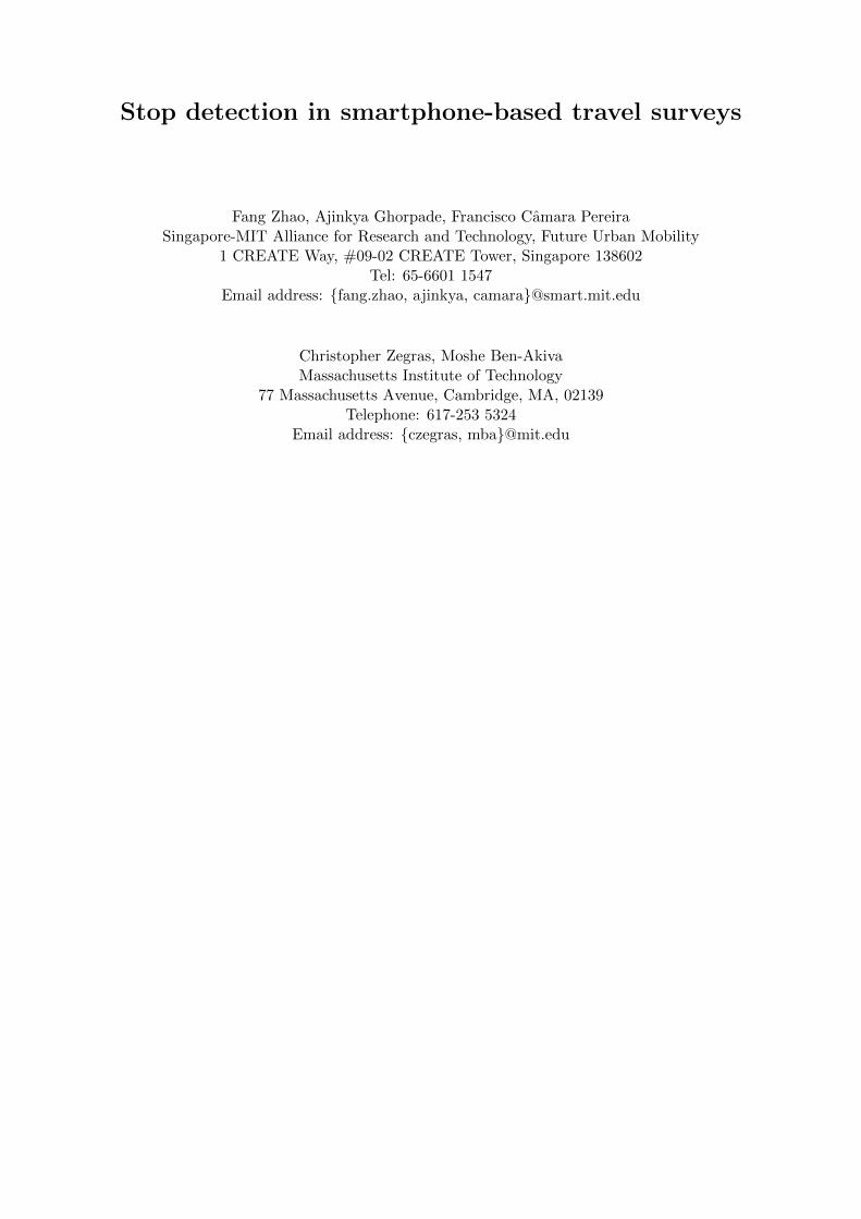
Figure 1: FMS architecture
demonstrate its effectiveness in the field test.The rest of this paper is organized as follows. Section 2 gives an overview of the FMS system.
Details of the stop detection algorithm used in FMS are presented in Section 3. The performanceof the algorithm in our field test is discussed in Section 4, followed by the conclusions in 5.
2 FMS overview
FMS consists of three separate but inter-connected components - the smartphone app thatcollects the sensing data; the server that includes the database as well as the data processingand learning algorithms; and the web interface that users access to view and validate theprocessed data and respond to additional questions to supplement the validated data. Thethree components and the flows of data among them are shown in Figure 1.
2.1 Smartphone app
The smartphone app, available for both Android and iOS platforms, collects data from a mul-titude of sensors available on the phones including GPS, GSM, accelerometer and WiFi. Oneof the main objectives of the FMS app design is non-intrusiveness, i.e., the app runs in thebackground of the phone and silently collects the sensor data without user intervention. Par-ticipants would therefore not be influenced in anyway by the application during their normaldaily activities. In addition, the application is designed to be light-weight and easy to use.A major concern for location based applications is battery consumption, and we have madevarious efforts to minimize battery consumption [Nawaranthne et al., 2014]. The sensor datacollected on the phone are transferred to the back-end server through either the cellular networkor WiFi, based on the user’s preference.
2.2 Backend server
Raw data collected via the app are uploaded to a database where a series of algorithms are usedto process the data and make inferences about stops, travel modes and non-travel activities. Tominimize the user’s interaction burden, the backend algorithms translate raw data into tripsand activities. The first round of stop detection is made based on location and point-of-interest(POI) data. GSM, WiFi and accelerometer information are used to merge stops that wouldotherwise be interpreted as distinct stops. More details on the stop detection algorithm arepresented in Section 3. Travel modes are detected based on GPS and accelerometer features,as well as public transit location information. Non-travel activities (e.g. home, work, change
4
F. Zhao et. al. Stop detection in smart phone based travel surveys
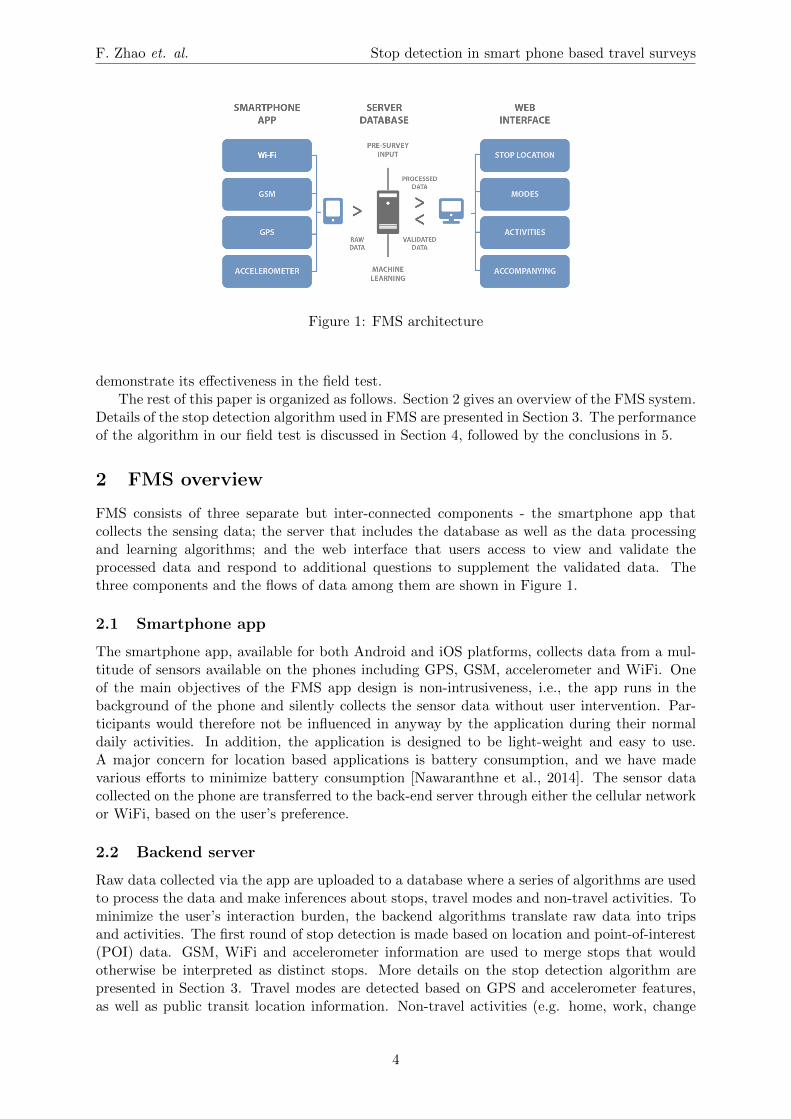
Figure 2: FMS web-interface – Activity Diary
mode/transfer) are also detected based on previous validations by the user, POI data and othercontextual information.
2.3 Web-interface
The web interface provides a platform that enables users to review their processed data in theform of a daily timeline or activity diary and “validate” their data for a limited number ofdays (Figure 2). Validation involves filling in missing information and amending incorrectlyinferred data about stop locations and times, modes of travel used for particular trips, andspecific activities engaged in at locations deemed to be non-travel time segments or “stops”.The validated data are uploaded and the algorithm learns to make better inferences as the userinteracts with the interface. The website also is flexibly designed to enable supplementary datato be collected from users. Supplemental data pertaining to a specific trip (e.g. how manypeople the user traveled with or what, if any, fee was paid for parking) are collected withinthe activity diary validation stage. A helpdesk was available for users to interact with throughchat or phone call and users are encouraged to have a session with a helpdesk representativefor assistance during their first data validation.
3 Stop detection algorithm
As mentioned in Section ??, the challenge of stop detection in smartphone based travel surveyslies in the absence of continuous high quality location data. GPS signal is not accurate or evenmissing in densely build up areas due to the urban canyon effect, and we observe this oftenin the downtown areas of Singapore. Also, when the user is indoors or underground, there isno GPS reading. In such cases, the phones will provide low accuracy location data based onGSM cell tower information and WiFi information (if WiFi is switched on on the phone). Thisleads to very noisy and jumpy location data when a user is at an indoor stop. In addition
5

F. Zhao et. al. Stop detection in smart phone based travel surveys
to these physical limitations, we also purposely introduced time gaps in location readings toreduce the burden of our app on the smartphone battery. As continuous sampling with GPSdrains battery very fast, we introduced duty cycle for GPS sensor to preserve battery (phased-sampling) [Nawaranthne et al., 2014]. We also stop GPS collection when the phone is stationary.All these have impact on the availability and quality of the location data we collect, and posea challenge to the stop detection algorithm.
In FMS, a stop is defined as a single instance of a user spending some time in a placeperforming an activity that is relevant to travel behaviour modelling. For example, we wantto detect stops where users change transportation mode or transfer bus/trains, although theycan be very short. On the other hand, we do not want to include stops at traffic lights, trafficjams, or bus/train stops where the user did not get on/off. As we do the stop detection almostin real-time, i.e., users are able to view and validated their activities and trips soon after theyhave performed them, we decided to start with a rule-based approach for stop detection. Thereare six main steps in this algorithm, which are explained in detail below.
1. Filter raw data – The first step is to filter the noisy raw location datas to remove thepoints that are likely to be very far from the real location of the user’s. This happenfrequently when GPS signal is not available and the location is deduced from GSM celltower information, but we have also come across scenarios when the GPS reading is very faroff (distance error of tens of kilometres). Most of these points can be identified by checkingthe accuracy level of the location points provided by the phones. In addition, we note thaterroneous GPS readings typically has wrong altitude readings as well. Since Singaporeis near sea level and relatively flat, we also remove the readings with exceptionally highaltitudes.
2. Generate candidate stops – We perform the first round stop detection by matching theGPS location sequence to spatial/temporal windows to generate candidate stops [Hari-haran and Toyama, 2004]. A stop is generated if the location data indicates that theuser has been within in an area of 50 meters in diameter for at least one minute. WhenGPS is unavailable, we use the less accurate location estimation based on GSM cell towerinformation. We generate candidate stops with duration as short as one minute to cap-ture small stops such as mode change and pick-up/drop-off, which are typically ignoredin traditional travel surveys. Information on such stops can play an important role intransportation modelling and planning.
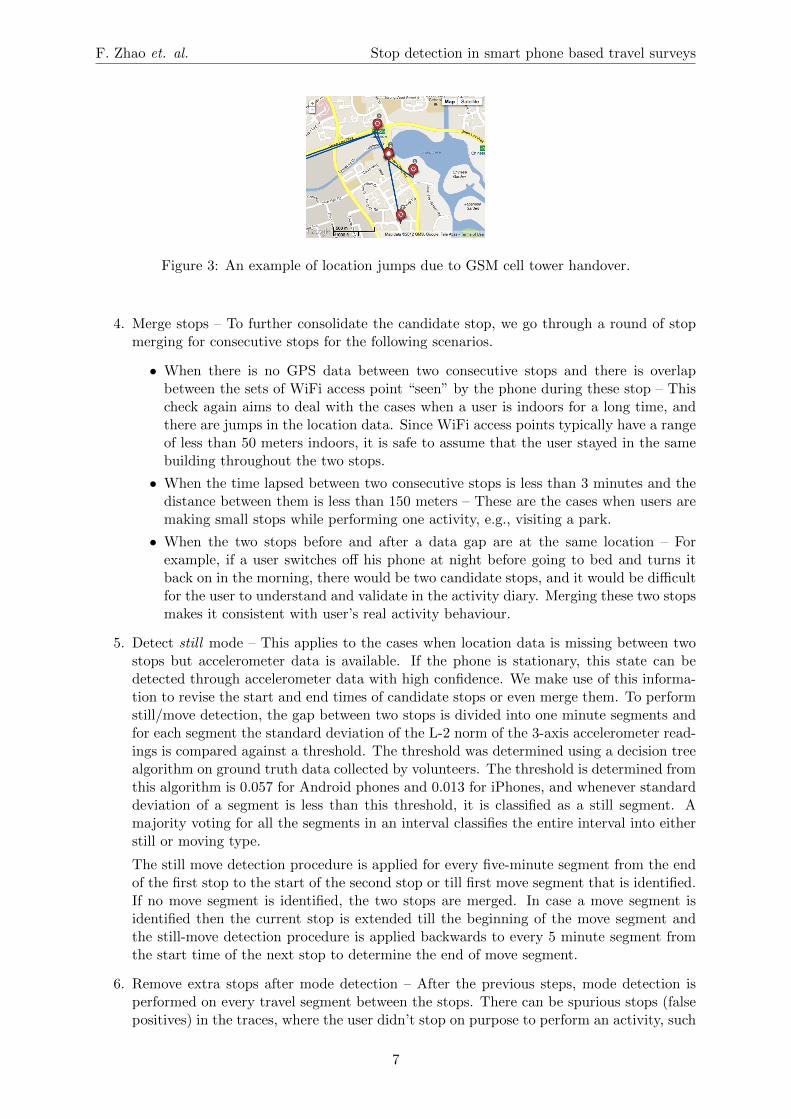
3. Check against frequent place signatures – With real life smartphone data, the quality ofthe candidate stops varies greatly, and one of the main problems is that a long stop bythe user at a particular location can be broken into several stops far away from each otherdue to the hand-over of the phone among several GSM base stations. Figure 3 shows anexample of such GSM location jumps. This problem is especially prominent at home andwork locations, as users stay for extended periods of times indoors at these locations. Toimprove the quality of these stops, we used GSM signatures of frequently visited placesfor each user. User’s frequently visited places, such as home or office, are recorded inthe system after registration or when they are validated by the user in the activity diary.The backend algorithm then records all the GSM cell towers that has been “seen” by thephone while at these locations. The list of GSM cell towers associated with a frequentplace is called its GSM signature. When a new candidate stop is generated, the algorithmchecks if the phone is using any of the cell towers in the GSM signatures. If a match isfound, the stop is moved to the recorded home or office location. This method effectivelyreduces the “jump” in stops at these locations. Similar signatures can also be generatedfor WiFi access points at frequently visited places.
6
F. Zhao et. al. Stop detection in smart phone based travel surveys
Figure 3: An example of location jumps due to GSM cell tower handover.
4. Merge stops – To further consolidate the candidate stop, we go through a round of stopmerging for consecutive stops for the following scenarios.
• When there is no GPS data between two consecutive stops and there is overlapbetween the sets of WiFi access point “seen” by the phone during these stop – Thischeck again aims to deal with the cases when a user is indoors for a long time, andthere are jumps in the location data. Since WiFi access points typically have a rangeof less than 50 meters indoors, it is safe to assume that the user stayed in the samebuilding throughout the two stops.
• When the time lapsed between two consecutive stops is less than 3 minutes and thedistance between them is less than 150 meters – These are the cases when users aremaking small stops while performing one activity, e.g., visiting a park.
• When the two stops before and after a data gap are at the same location – Forexample, if a user switches off his phone at night before going to bed and turns itback on in the morning, there would be two candidate stops, and it would be difficultfor the user to understand and validate in the activity diary. Merging these two stopsmakes it consistent with user’s real activity behaviour.
5. Detect still mode – This applies to the cases when location data is missing between twostops but accelerometer data is available. If the phone is stationary, this state can bedetected through accelerometer data with high confidence. We make use of this informa-tion to revise the start and end times of candidate stops or even merge them. To performstill/move detection, the gap between two stops is divided into one minute segments andfor each segment the standard deviation of the L-2 norm of the 3-axis accelerometer read-ings is compared against a threshold. The threshold was determined using a decision treealgorithm on ground truth data collected by volunteers. The threshold is determined fromthis algorithm is 0.057 for Android phones and 0.013 for iPhones, and whenever standarddeviation of a segment is less than this threshold, it is classified as a still segment. Amajority voting for all the segments in an interval classifies the entire interval into eitherstill or moving type.
The still move detection procedure is applied for every five-minute segment from the endof the first stop to the start of the second stop or till first move segment that is identified.If no move segment is identified, the two stops are merged. In case a move segment isidentified then the current stop is extended till the beginning of the move segment andthe still-move detection procedure is applied backwards to every 5 minute segment fromthe start time of the next stop to determine the end of move segment.
6. Remove extra stops after mode detection – After the previous steps, mode detection isperformed on every travel segment between the stops. There can be spurious stops (falsepositives) in the traces, where the user didn’t stop on purpose to perform an activity, such
7
F. Zhao et. al. Stop detection in smart phone based travel surveys
as the ones at traffic light, in traffic jams, or at bus/train stations during the user’s transittravel. To minimize this problem, we developed rules to remove short stops between twomotorized modes. This has proved effective to remove a large number of spurious stops,and reduces user’s validation burden. However, it may delete some of the short drop-off/pick-up stops, which the users will have to add in the activity diary during validation.One possible way to improve on this is to incorporate user history in stop detection. If auser has validated a drop-off/pick-up stop at a certain location before, the algorithm doesnot remove candidate stops at that location in the future.
After the above six steps, the final set of stops are determined, which are presented in theactivity diary for the users to validate. With this relatively simple algorithm, we could kick startthe project and collect real world data. The collected data are being used used for developingmore sophisticated machine learning algorithms to be used in the next version of FMS.
4 Experimental results and discussion
In this section, we present experimental results of the FMS stop detection algorithm in twotests. One with student volunteers, and one with public users.
4.1 Test with volunteers
One difficulty in testing the accuracy of the stop detection algorithm is finding out the groundtruth of the users’ stops. Through our own experience and also during various test, we foundthat users are reluctant to change the stops generated by the system. Particularly, if the stopdetection algorithm misses a stop, it is very rare that a user would add it back during validation.This may be due to memory issues or due to the extra effort required to add a new stop in theinterface. Hence, we prefer to err on the side of false positives rather than false negatives. Inorder to better evaluate our algorithms, we engaged student volunteers to collect data and usedvarious methods to find out the ground truth.
A custom version of FMS application was developed for collecting annotated data and givenout to the volunteers. In this custom version, the FMS application is modified to allow thevolunteers to annotate start and end times of their stops and trips, as well as their modes oftransportation. Volunteers carried the phones with them for more than 4 months all the time.To ensure the quality of the data the volunteers were asked to carry a paper diary and registerthe start and end of each trip in it. The participants were issued travel cards (EZLink cards) tomake payments for the train, bus and taxi trips. The transaction logs from the EZLink cardswere later used to filter the erroneously annotated trips. In addition, the volunteers were askedto validated their activity diary everyday, and all these sources of information are considered ingenerating the ground truth of the user’s stops and trips.
Overall, after processing, we have 5807 hours of data from 15 phones collected by 8 volun-teers. The stop detection accuracy is 91.24% and 13.3% of the detected stops are false positives.
4.2 Field test with HITS
FMS was also field tested in conjunction with Singapore Land Transport Authority’s House-hold Interview Travel Survey (HITS) from October 2012 to September 2013. More than 7800user-validated days of travel data were collected from more than 1500 users. Based on uservalidations, the true positive rate of our algorithm is 95.5% and 12.3% percent of the detectedstops were false positives. As mentioned earlier, users tend to trust the system generated stopsmore than they should, and the actual stop detection accuracy should be lower than these num-bers, as shown above. In fact, designing a meaningful and consistent measure to truly reflect
8

F. Zhao et. al. Stop detection in smart phone based travel surveys
the stop detection accuracy and its effect on user burden is a difficult problem in itself, and ispart of our on-going work.
4.3 Discussion
Although the stop detection algorithm had high detection accuracy, we observed several prob-lems that can impede users’ understanding of the activity diary and make the validation processcumbersome and error-prone.
One main problem is the “jumps” in long in-door stops. For example, if a user stays atwork for 8 hours, FMS might detect it as two stops with an erroneous short trip in between.This is mainly due to the fact that GPS reading is not available when the user is indoors, andthe location readings based on GSM cell towers will jump due to the hand overs. Also, we haveobserved cases where there appears to be GPS datas outside the stop for some time during thestay, and the algorithm mistakenly conclude that the user took a short trip before returning tothe same location. As mentioned in the previous section, this problem can be partially rectifiedby using the GSM and WiFi signatures of the frequent places that the user has validated before.Still it remains as one of the main issues in stop detection.
The second issue relates to the detection of change mode/transfer stops. From a trans-portation modelling/planning point of view, it is important to collect information regarding thelocation and waiting times at stops where users transfer or change transportation modes (e.g.,from walking to bus etc.). However, these kind of detailed information is typically missed intraditional travel surveys, and in FMS, we strive to recover them from users’ raw data. Wefound that, in general, it is easier to detect users’ boarding stops, as they would usually waitfor a short period of time before boarding a bus/train. The alighting stops, on the other hand,are very difficult to capture, as passengers would move away immediately after leaving thebus/train, and we cannot infer the “stop” based on the location data. One possible solutionfor this problem is to examine the accelerometer data closely. Since there is typically a distinctfeature for walk segments in the accelerometer data, we can use “change point detection” tolocate the alighting stops.
Finally, when we compared the data collected in FMS with data collected in HITS, it isobserved that FMS fails to detect some of the pick-up/drop-off stops. This is expected as wedelete short stops if the transportation mode before and after the stops are the same motorizedmode, as we explained in Section 3. It is done to reduce the spurious stops due to traffic lightand/or transit stops en route the user’s trip. Therefore, there is a trade-off between detectionaccuracy of the “valid” short stops by the users and the false positives.
The above problems can be improved by incorporating Point of Interest (POI) information,such as road junctions, bus and train stops etc. In addition, one main advantage of the FMSsystem is that it acquires individual history data through the validation process. Our systemcan learn from the personal history and make better inferences over time. For example, if a userhas previously validated a pick-up stop at a certain location, the algorithm should not delete astop at this location even if it is very short. The current rule-based stop detection algorithmis not making full use of this valuable information, and as part of our ongoing work, we aredeveloping an integrated stop mode detection algorithm using machine learning techniques withfeatures based on POI information and user history [Ghorpade et al., ]. This novel algorithm ismore robust to noise in the raw data, and has higher stop/mode detection accuracy. In addition,we are exploring the usage of accelerometer change point detection to find the small stops whichwould be otherwise missed by looking at the location data solely. The large amount of datacollected in the field test with HITS is being used for training the models for this improvedalgorithm.
9

F. Zhao et. al. Stop detection in smart phone based travel surveys
5 Conclusions
To the best of our knowledge, FMS is the first smartphone based travel survey system that hasgone through large-scale field test with public users. The huge amount of raw and validated datacollected as well as user feedback gathered are valuable inputs that can help us further improvethe system. As mentioned above, the stop detection accuracy is vital to ensure the quality ofuser validated data. A few erroneous stops would increase the user-burden tremendously, andin general, false positives are preferred over false negatives. In this paper, we present the stopdetection algorithm we employed in the FMS field test, which achieved an accuracy of 95.5%.To further improve the stop detection algorithm, we are working on an integrated stop modedetection algorithm using matching learning techniques, which incorporates other inputs suchas context data (POI, events, traffic condition etc.) and user’s history.
Acknowledgements
The authors gratefully acknowledge Land Transport Authority of Singapore for their supportand help throughout the field test. This research was supported by the National ResearchFoundation Singapore through the Singapore MIT Alliance for Research and Technology’s FMIRG research programme.
References
Bohte, W. and Maat, K. (2009). Deriving and validating trip purposes and travel modes formulti-day gps-based travel surveys: A large-scale application in the netherlands. Trans-portation Research Part C: Emerging Technologies, 17(3):285–297.
Carrion, C., Pereira, F. C., Ball, R., Zhao, F., Kim, Y., Nawaranthne, K., Zheng, N., Ben-Akiva,M., and Zegras, C. C. (2014). Evaluating fms: a preliminary comparison with a traditionaltravel survey. In Transporation Research Board 93rd Annual Meeting.
Cottrill, C., Pereira, F. C., Zhao, F., Ines, D., Lim, H. B., Ben-Akiva, M., and Zegras, C. C.(2013). Future mobility survey: Experience in developing a smartphone-based travel sur-vey in singapore. Transportation Research Record: Journal of the Transporation ResearchRecord, 2354:59–67.
Ghorpade, A., Pereira, F. C., Zhao, F., Zegras, C. C., and Ben-Akiva, M. An integrated stop-mode detection algorithm for real world smartphone-based travel survey. submitted toTransportation Research Board 94th Annual Meeting.
Ghorpade, A., Shuang, S., Zhao, F., Pereira, F. C., Zegras, C. C., and Ben-Akiva, M. (2014).Quality of prompted-recall responses in smartphone based travel survey. In 10th Interna-tional Conference on Transport Survey Methods.
Hariharan, R. and Toyama, K. (2004). Project lachesis: Parsing and modeling location histo-ries. In Geographic Information Science: Third International Conference (GIScience ’04),Adelphi, USA. Springer-Verlag GmbH.
Montoliu, R. and Gatica-Perez, D. (2010). Discovering human places of interest from multimodalmobile phone data. In 9th International Conference on Mobile and Ubiquitous Multimedia(MUM), Limassol, Cyprus.
Nawaranthne, K., Zhao, F., Pereira, F. C., Zegras, C. C., and Ben-Akiva, M. (2014). The impactof gps based outdoor activity detection on smartphone battery life. In 10th InternationalConference on Transport Survey Methods, Australia.
10

F. Zhao et. al. Stop detection in smart phone based travel surveys
Oliveira, M. G. S., Vovsha, P., Wolf, J., Birotker, Y., Givon, D., and Paasche, J. (2011).Global positioning system-assisted prompted recall household travel survey to support de-velopment of advanced travel model in jerusalem, israel. Transportation Research Record:Journal of the Transportation Research Board, 2246:16–23.
Stopher, P., FitzGerald, C., and Xu, M. (2007). Assessing the accuracy of the sydney householdtravel survey with gps. Transporation, 34(6):723–741.
Stopher, P. and Wargelin, L. (2010). Conducting a household travel survey with gps: reportson a pilot study. In 12th World Congress on Transport Research, Lisbon, Portugal.
Wan, N. and Lin, G. (2013). Life-space characterization from cellular telephone collected gpsdata. Computers, Environment and Urban System, 39:63–70.
11


![Rights / License: Research Collection In Copyright - …30227/... · [Stopher 1992]. This paper first ... Three pairs of nationwide survey datasets are used, ... Last, sampling methods](https://img.pdfslide.net/doc/110x75/5b92f66f09d3f27f5d8c423a/rights-license-research-collection-in-copyright-30227-stopher-1992.jpg)