Embed Size (px)
Citation preview

1
STRATEGIC UNIT FOR PROJECTS, BUSINESSES AND ASSOCIATED SERVICES
GEOTHERMAL RESOURCES SERVICE CENTERENVIRONMENTAL MANAGEMENT SERVICE CENTER
ENVIRONMENTAL IMPACT STUDYLAS PAILAS GEOTHERMAL PROJECT
ENVIRONMENTAL IMPACT DECLARATION (EID)
SETENA FILE No. 788-04
2
ENVIRONMENTAL IMPACT STUDY LAS PAILAS GEOTHERMAL PROJECT.
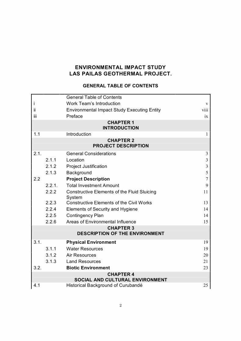
GENERAL TABLE OF CONTENTS
General Table of Contentsi Work Team’s Introduction vii Environmental Impact Study Executing Entity viiiiii Preface ix
CHAPTER 1 INTRODUCTION
1.1 Introduction 1CHAPTER 2
PROJECT DESCRIPTION2.1. General Considerations 3
2.1.1 Location 32.1.2 Project Justification 32.1.3 Background 5
2.2 Project Description 72.2.1. Total Investment Amount 92.2.2 Constructive Elements of the Fluid Sluicing
System 11
2.2.3 Constructive Elements of the Civil Works 132.2.4 Elements of Security and Hygiene 142.2.5 Contingency Plan 142.2.6 Areas of Environmental Influence 15
CHAPTER 3 DESCRIPTION OF THE ENVIRONMENT
3.1. Physical Environment 193.1.1 Water Resources 193.1.2 Air Resources 203.1.3 Land Resources 21
3.2. Biotic Environment 23CHAPTER 4
SOCIAL AND CULTURAL ENVIRONMENT4.1 Historical Background of Curubandé 25

3
CHAPTER 5 ENVIRONMENTAL MANAGEMENT PLAN
5.1 Environmental Management Setup 355.2 Monitoring and Follow-up Plan 36
INDEX OF FIGURES
2.1 Project Location 42.2 Sluicing System Plan 122.3 Area of Environmental Influence 16
INDEX OF TABLES
2.1 Comparison between Capital Cost and Net Power Generation 10
2.2 Comparative Generation of the Plant and Operation Charges for Evaporation and Binary Plants 10
5.1 Las Pilas GP Environmental Management Plan 38
INDEX OF ILLUSTRATIONS
4.1 Las Pailas Geothermal Project Surroundings 254.2 Curubandé Center in Liberia. 27

4
I. -{}-WORK TEAM'S INTRODUCTION
The following professionals, all employees of the Costa Rican Institute of Electricity (ICE), have participated as a multidisciplinary group in the creation of this Environmental Impact Study:
[Signature]Forestry Expert David Guadamuz Leal. EngineerLicense No. 36-95SETENA Registry Number 136-03
[Signature]Geographer Max Ureña Ferrero, MSc.SETENA Registry Number 166-96
[Signature]Engineer Laura Carmona. MoreraLicense No. 6153SETENA Registry Number 105-99
[Signature]Economist Dora Carias Vega, MSc.License No. 13554SETENA Registry Number 26-98
[Signature]Archeologist Ana Cristina Hernández Alpizar, Bachelor’s degreeSETENA Registry Number 030-99
[Signature]Sociologist Alejandro Aguilar Sura, Bachelor’s degreeLicense No. 10598SETENA Registry Number 86-01
[Signature]Geologist Guillermo Alvarado Induni, PhDLicense No. 103SETENA Registry Number 106-99
[Signature]Statistical Economist Sergio Guillen Murillo, Bachelor’s degree

5
License No. 1971SETENA Registry Number Cl 116-2004.
[Signature]Geologist Manuel BarrantesLicense No. 258SETENA Registry Number 147-2004
[Signature]Engineer Hartman Guido Sequeira (Atmosphere)License No. ICO-8338SETENA Registry Number 098-01
[Signature]Chemist Antonio YockLicense No. 234SETENA Registry Number 146-2004
[Signature]Engineer Joaquín Guerrero VegaLicense No. ICO-2891SETENA Registry Number 172-2004
[Signature]Biologist Fernando Chavarría Picado, CoordinatorC.B.C.R. License No. 526SETENA Registry Number 0171-96
[Signature]Geographer Joaquín Méndez Arguello, Bachelor’s degreeSETENA Registry Number 079-01
[Signature]Geographer Randall Acuña Torres, Lic.SETENA Registry Number 0176-96
[Signature]Engineer Miguel Chinchilla AcuñaLicense Number No. 3559SETENA Registry Number 140-98
[Signature]Geographer Gerardina Araya Astorga, Bachelor’s degreeSETENA Registry Number 037-99
[Signature]Attorney Claudio Zeledón Rovira, Bachelor’s degreeSETENA Registry Number 136-2001
[Seal]: CLAUDIO GMO. ZELEDON ROVIRAATTORNEY AND NOTARYSAN JOSE, COSTA RICA

6
I authenticate: [Signature]
[Illegible seal]
Collaborations:We especially appreciate the collaboration of the following persons that with their support and suggestions made of this study a better quality document: Engineer Jorge Valverde Barrantes, Director of the Environmental Management Center, for his technical support and general review of the study; to Geographer Rogelio Zeledón Ureña, for his coordination before the Feasibility study; to Mr. Luis Artavia Alpízar for his contribution to SIG, his calculations and Plan Design, to the Master of Science Virginia Cascante Madrigal, for her help with the communities; to the Engineer Alejandro Luna for her contribution to the Transmission Lines; to the Geologist Rafael Barquero Picado for his contribution in seismic threat; to the Geologist Fernando Molina Zúñiga, for his collaboration on underground water and geology; to the Bachelor’s degree holder Ricardo Zalazar Campos for his collaboration on Occupational Health, to the Geologist Ricardo Soto Bonilla for his contribution in Vulcanology; to the Forestry Expert Jesús Vasquez, for his contribution in the field work, dumps, and waste; to the Engineer Javier Villalobos for his technical contribution, to the Master of Science Alberto Vargas Villalobos, to Mr. Gustavo Robles Viales; for his collaboration in field work and recognition of the zone; for his collaboration with calculations, to the Biologist Oscar Chávez Badilla for his contribution in biology and Ms. Francini Aguilar Carballo for her logistical help. Also to those ICE Service Centers, which provided technical information about seismology, soil, physicochemical and hydrologic analysis, underground exploration, geothermics and design.

7
ii. ENTITY EXECUTING THE STUDY
The Costa Rican Electricity Institute (Instituto Costarricense de Electricidad - ICE), through the Environmental Management Center, the coordinating entity of the Las Pailas Geothermal Project Environmental Impact Study (EsIA), was created as an Autonomous Institution in the year 1949 and was conceived from its origin as the governing entity and main executor of the development and administration of the national electric industry.
Public Services Regulatory Law, Law No. 7593 from September 5, 1996, in its Article 71 “authorizes public institutions that provide services to sell directly to other public or private companies or institutions, national or foreign, advising services, consulting, training or any other activity for which they are qualified.”
ICE submitted for the consideration of the National Environmental Technical Secretariat the documentation required to process its registration in the Environmental Consultant Registry, and it became registered as a consulting company in record No. 0030 - 96. Also as independent consultants to the multidisciplinary group that created the environmental impact study.
For the purpose of fulfilling the current national environmental guidelines established in the Organic Environmental Law No. 7554, the environmental guidelines established by the National Environmental Technical Secretariat (SETENA) of the Ministry of Environment and Energy (MINAE), and the Ministry of Health, Las Pailas Geothermal EnvironmentalProject Evaluation has been requested to the corresponding entities, through the presentation of the FEAP No. 788-04, on September 13, 2004 and through resolution No. 2487-2004-SETENA of December 13, 2004 SETENA resolved in session No. 046-2004 to continue with the environmental evaluation process, for which purpose the Environmental Impact Study was requested, through the requirements indicated in FETER of December 14, 2004.
The administrative file, from SETENA referring to the Las Pailas Geothermal Project, corresponds to No. 788-04, of September 13, 2004.
The Environmental Impact Study, carried out by ICE, in this sense fulfills the requirements requested in the FETER, and describes among other things the technical elements of the Project, detailed description of the environment in all its components (physical, biotic and human), the environmental impacts of all the areas involved, procedures and responsible parties for the actions to consider during the construction and operation of the Machine Hall, in the Environmental Management Plan.

8
iii. PREFACE
This report is the result of the Environmental Impact Study (EsIA), of the Las Pailas Geothermal Project, to be developed by the Costa Rican Electricity Institute (ICE) in the Canton of Liberia, in the Province of Guanacaste.
The installation of this geothermal plant is necessary to support the hydroelectric plants during maintenance and contingency periods, and also during dry seasons; times in which the hydroelectric system is most affected by climate variation, as well as to improve the availability of electricity in the country.
For the case being studied, the environmental needs are defined with respect to the distance between the geothermal plant and the neighboring population centers, as well as the needs for access routes, location, water supply and basic services.
The environmental aspects, such as contamination by solids, liquids or gases and noise due to the plant operation, are aspects that are analyzed in this study, in addition to the remaining social, biotic and abiotic aspects related to geothermal plants.
Conditions with the greatest wind speed are most favorable for the dispersion of gasses, as well as those with the most stable atmosphere, given that the current of contaminants is distributed further from the emission point before it reaches the ground level.
For the characteristics of the equipment itself that will be installed, a source of controlled noise will be established, which would potentially affect the operators first, who will need to use the pertinent special equipment recommended for occupational health and second the distant neighbors, for which noise reduction constructions will be used to attempt to minimize the effect.
The environmental viability of the geothermal plant installation, in the Curubandé site, is high, considering the ample land lot and that it is located at a substantial distance from populated centers, and due to other environmental characteristics that are analyzed in the environmental impact study, and also if all the environmental provisions coming out of the study are carried out.

9
CHAPTER 1 1.1 INTRODUCTION
This task is a multidisciplinary effort from different Service Centers of the Costa Rican Institute for Electricity (ICE), to create the Environmental Impact Study (EsIA) for the Las Pailas Geothermal Project, and its purpose is precisely to serve as a guiding document for the execution thereof.
Another objective is to be able to describe the environmental impact of the site so that it may serve as a point of reference concerning the environmental complexity associated with the eventual development of geothermoelectric power in the zone known as Las Pailas, located on the western flank of the volcanic bed of Rincón de la Vieja, in the canton of Liberia, province of Guanacaste. This document presents in an orderly and in-depth fashion the information compiled in the office and in the field, in addition to the description of the research work carried out up to the month of May of the year two thousand five, about the zone’s geothermal resource potential, as well as an environmental characterization of the geographic space where the project is located, with its respective evaluation and impact mitigation.
The team of professionals that was formed to conduct the Environmental Impact Study, at the request of the coordinating office, made an initial forecast of the environmental impacts that could result from an eventual construction of the project (Project’s Environmental Profile). ICE, 2002). As a result of this task the environmental impact study was then carried out, with a more exhaustive list of potential impacts that the project could have, then the environmental measures that could be applied were identified; in some cases these were carried out and their respective implementation costs were evaluated, along with conclusions and recommendations, to improve the environment.
This study should be interpreted as an exhaustive work, starting from a description of the project, continuing with a very detailed description of the environment, which allowed the team to carry out an adequate interaction, interpretation, identification and assessment of the impacts in detail, generating a very objective evaluation of the project, which allowed for the generation of mitigation, prevention, and valuable supportive compensation methods for the environmental surroundings where the project is being developed.
In itself, the study emphasizes the interactive analysis of the environment versus the project, on the part of the interdisciplinary group, which provides the evaluator with greater tools for environmental viability that could be seen from the project, and with a more complex field information and analysis process, giving greater support to the environmental impact study.

10
CHAPTER 2 PROJECT DESCRIPTION
2.1. GENERAL CONSIDERATIONS
In this chapter those details relating to the project are described, allowing an evaluation of its size and temporal and spatial scope.
2.1.1 Location:
The Las Pailas Geothermal Project is located on the piedmont of the southwestern flank of the Rincón de la Vieja volcanic bed, between 500 and 700 m above sea level. Its drainage area is shared by the micro-basins of the Blanco and Colorado rivers; both rivers converge with the name of the second to the Tempisque river, the main hydrographic basin of the Pacific Northern Region of the Country.
Its cartographic location extends from plane coordinates 303 – 306 N and 384 – 390 E. Cartographic page 3148 III Curubandé, National Geographic Institute, Scale 1:500 000 (Figure No. 2.1). Its political – administrative location is found in Districts No. 5 Curubandé and No. 1 Liberia, of the Canton of Liberia (1st), Province of Guanacaste.
2.1.2. Project Justification
The economy of Costa Rica has grown thanks to a series of actions that have made it possible to grant the country a productive and socially appropriate infrastructure, in fields as diverse as transportation, port infrastructure, electrical service, telecommunications, potable water, distribution of hydrocarbons, health, education and others. (ICE, 2003). One of the vital fields is obviously the electrical field, because without such sufficiently high-quality service, and at the right moment, different areas of our economy would not have been able to grow.
The electrical system has fulfilled its goals with respect to the Costa Rican society, having had, at times, problems of lack of capacity to fully satisfy demand. This is because only the most necessary investments are being made to avoid service failures, but they could have a negative effect when special circumstances occur. The energy reserve margins are very moderate and the ongoing economic crisis and the legal and regulatory framework have caused frequent delays in financing, whether from external credit or from fees, as well as delays in the processes of contracting and execution of generation, transmission and distribution works. Based on the projection of the projected electrical demand and the different available and operating energy sources evaluated, the plan is then defined for expanding generation at a minimum cost to the country.The growth projected in annual electricity consumption is 7% during the years 2003 and 2004; which is higher than the growth index of the country’s installed capacity, and therefore, in the future it is foreseen having to face a possible scarcity of electrical flow, especially starting from the summer of 2005.

11
To carry out the demand projections, a mathematical model is used, which requires the entry of information on the current plants in operation, on projects under construction and on future projects.
Among the characteristics that are required by the project model of the different projects are: Installed potential, average energy, operation and maintenance costs, cost and type of fuel, local and external investment, efficiency, maintenance periods, useful reservoir volume, hydrology and future demand.
The product of such model is the Generation Expansion Program, which is the sequence of plants of different size and nature, whose entry into service is obtained for the entire group, as part of the optimal solution.
This technical and economical solution includes geothermal generation, which is necessary to support the hydroelectric plants during periods of maintenance, contingency or dry seasons, times in which the hydroelectric system is more affected by climatic variation, and during daily peak periods.
To date, it has been determined that the water is the most abundant resource in the country and given its characteristics it becomes the most favorable option, not only from the technical point of view but also from the economic one, for which reason, the national electric system is based on the use of the hydraulic resources for electrical production (82%).
Nevertheless, given the lack of viability of various hydroelectric projects to store water and given the hydrological forecasts for the country especially during the dry seasons, the need is foreseen to have geothermal Generation as base energy of the system in order to maintain an adequate balance between the regulation plants and the demand.
2.1.3 Background:
The exploration of geothermal potential in this zone began at the start of 1975, and even in 1963 the zone had already been visited by a group of specialists from the United Nations at the request of the ICE, whose result was a first report of acknowledgement. The studies carried out between the years 1975 and 1976 were focused on the following areas: Geology, geochemistry, electric resistivity, gravimetry, geohydrology and heat flow; all being superficial studies. These studies provided information on the conditions of stratigraphy, lithology, temperature gradient, hydrochemistry and resistivity structure of the
area.1
During the 1980s, while geothermal potential across the country was being recognized, other studies were included in the zone of interest of the southwestern flank of the Rincón de la Vieja volcanic bed. Among the results from this time, a description of the Guanacaste mountain range was obtained, starting from satellite images and aerial photographs and field validation.
2

12
During the 90s, research was resumed as of 1992 in the area of gravimetry. At the beginning of 1994, ICE requested a consulting firm to create a provisional work plan to continue the prefeasibility studies in the areas of Las Pailas and Borinquen. In 1996 ICE drilled 9 temperature gradient wells (of a depth < 500 m).
In the last years other technical studies have been included, some of them oriented toward gathering data for the purpose of having a first approach toward knowledge of the environmental (physical - chemical) quality that is present in the zone. Since 2002 a stage has begun with a greater level of analysis of the environmental reach of the project in the zone, which included biological (flora and fauna) variables, social variables and strengthened the data gathering in the area of physical and chemical environmental quality, primarily atmospheric, hydraulic and soil.
3
1Rogers Engineering, CO., 1976. Guanacaste Geothermal Project, Ed. ICE, 70 pages,
Costa Rica 2
ICE, 2002. Environmental Profile of the Las Pailas Geothermal Project.
3Costar Rican Electricity Institute, 1991 Evaluation of Geothermal Potential of Costa Rica,
70 pages, Costa Rica
Procedures before SETENA
On February 28, 2000, the National Environmental Technical Secretariat (SETENA) was presented with the Preliminary Environmental Evaluation Form (FEAP) in order to initiate feasibility studies on the western flank of the Rincón de la Vieja volcanic bed. This first stage consisted of drilling 10 exploratory wells in the zones of Las Pailas and Borinquen, (5 wells in each of these two zones). This Secretariat assigned it Administrative File No.: 055-2000. In response to the FEAP review SETENA issued Resolution No. 203-2000 of March 7, 2000, which requested as a requirement for beginning the described studies, the presentation of a Legal Declaration of Environmental Commitments, a document that was delivered and then approved by SETENA through its Note S.G. 382-2000 of April 25, 2000, thus starting the Project’s environmental management stage. To date only 5 wells have been drilled in the Las Pailas zone, which has been separated and is processed under file No. 788-04, of September 13, 2004. Resolution No. 2487-2004-SETENA, of December 13, 2004, communicates to the ICE, to continue with the environmental evaluation process and the presentation of the Environmental Impact Study.
2.2. PROJECT DESCRIPTION

13
The total approximate area of the project is 1.0 km2, and within this land all the works
related to the project will be built, which are: Provisional installations Access routes and drilling terraces Deep wells Vapor ducts Separating stations Generating plant Substation and energy transportation works
For the development of Las Pailas a great concentration of human resources, laboratories, drilling equipment, camping and other specialized infrastructure will be used, available in the Miravalles Geothermal Field.
In the evaluation of the Geothermal potential of Costa Rica (ICE, 1991) the Rincón de la Vieja area was categorized as having a capacity estimated at 160 MW. The studies carried out to date confirm installation of a first unit of 35 MW.
The activities related to the project are divided into four stages; namely: 1. Geothermal feasibility study, 2. Development of geothermal field, 3. Design,
construction and work tests on the surface and machine hall, and 4. Tests and operation of works on the surface of the geothermal field and setting up Unit I.
Geothermal feasibility study: In this stage a feasibility study was prepared that integrated elements such as: Geoscientific studies, deposit characteristics, conceptual resource model, social, environmental and technical aspects related to the field -plant design, economic feasibility (cost-benefit analysis) and the environmental impact study.
To complete the technical feasibility it was necessary to carry out geoscientific studies and drill five deep wells to confirm the vapor production capacity and the reinjection of field fluids. This stage began at the end of the year 2000 and concluded with the publication of the feasibility report of the I Unit in Las Pailas in the month of July, 2005.
Development of the geothermal field: In this stage, it is estimated that it will be necessary to drill 12 additional wells, 8 for production and 4 for reinjection. This stage will begin with the acquisition of lands necessary to develop the project and continue drilling the missing wells to ensure both the required vapor flow for the unit, and for the reinjection of geothermal fluids that will be obtained as a result of this plant's operation.
The lands necessary to develop this field are located close to the Hacienda Guachipelín SA and Vistas del Place SA properties. Such properties must be negotiated by ICE.
Design, construction and surface work tests and machine hall.
Designs will be completed for the construction of surface works for the transport of hot and

14
cold fluids; the construction of the center, the substation and the access routes.
Tests and operation of geothermal field surface works and setting up Unit I: In this stage the functioning tests of the satellites and the fluid sluicing systems will be carried out. Once these tests are completed the commercial operation of the geothermic field will begin.
Plant Modality with vapor condensation turbine: This alternative is most typically used in geothermal fields because the geothermal fluid carries both vapor and brine, thus making a separation process necessary. After being separated, the vapor is expanded through a vapor turbine, which coupled to a generator axis produces electricity.
The vapor to condensation units are considered permanent installations because their infrastructure must include the need for a condenser, hot well pumps, cooling tower, system for extracting incondensable gases and recirculation pumps for cooling water.
These can be designed with a single vapor entry or with two entrances with different pressures. In the first the vapor is injected at a high pressure in the first stage of the turbine.
In the second case the residual brine from the separation evaporates again, obtaining vapor that is injected to the low pressure stage of the turbine. This second process increases the potential of the generation plant. Therefore, the increase can be relevant for purposes of central capacity. Generally, when using condensation turbines, condensers that have direct contact to condense the water in the turbine are used. This type of equipment is less expensive than the surface condenser and does not require the pump equipment.
Binary Plant Modality: In a binary cycle plant the heat contained in the geothermic brine is transferred through a heat exchanger to a work fluid, which has a lower evaporation point, and it is taken to the operation pressure through high pressure pumping. The pressurized liquid is evaporated in the exchanger. This high pressure vapor expands through a turbine that is joined at the axis of a synchronic electrical generator.
The low pressure vapor at the turbine exit passes to its liquid state by means of a condenser. This can be cooled with water or with air. Afterward, this liquid is compressed at high pressure and is recirculated through the exchangers to complete the binary cycle.
In conventional applications of energy generation plants using binary cycles, a temperature difference of 80ºC to 90ºC can be used. In the case at hand the extraction of heat is limited by the concentration of amorphous silica in the brine. It worth mentioning that the main advantage of the binary cycles is the generation of electricity with low temperature geothermal fluids that do not produce an adequate amount of vapor to use in the vapor cycle.
The binary cycle has evolved over time. It began with typical cycle applications, however in search of greater levels of efficiency a combined cycle plant design has been reached. This application consists of electrical generation through a counter-pressure turbine
15
(without condenser) whose escape is connected to a binary cycle heat exchanger.
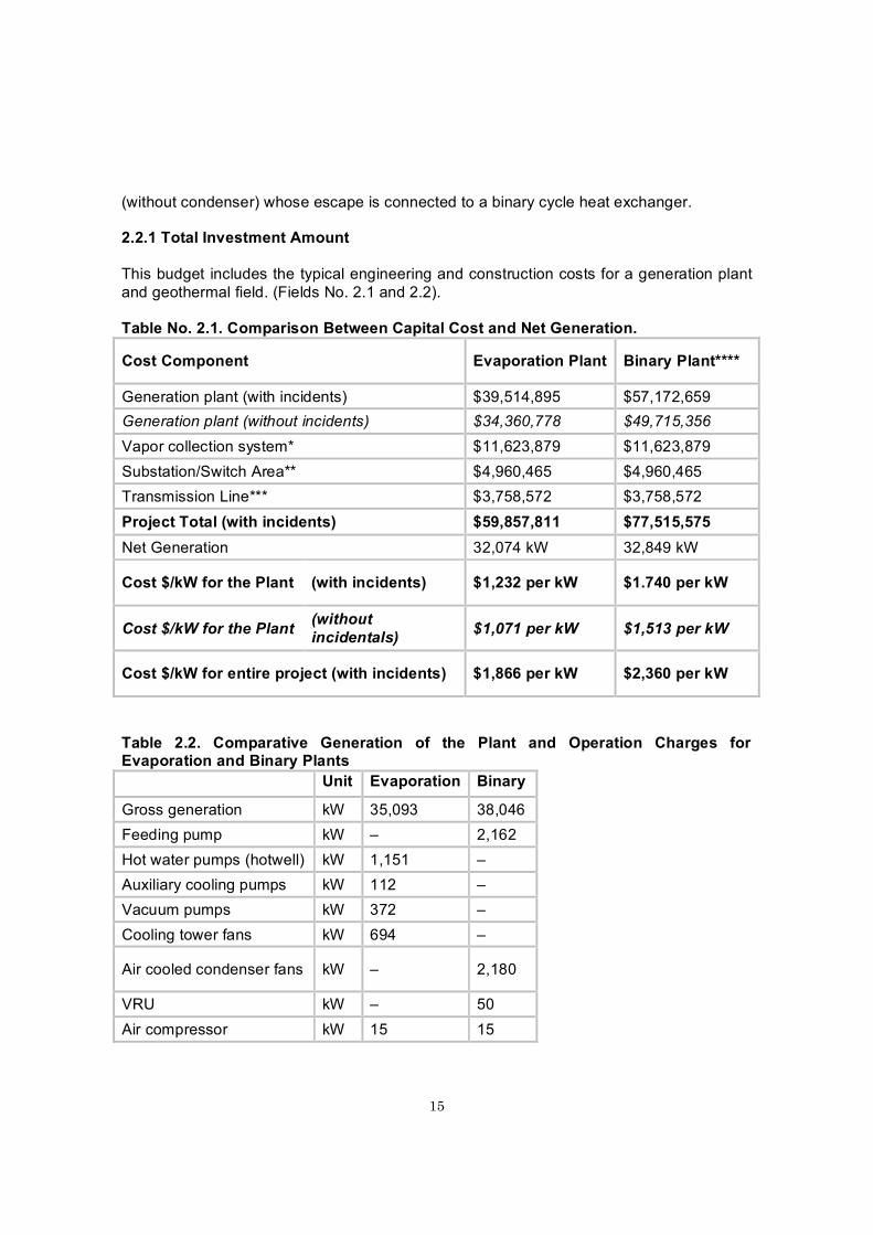
2.2.1 Total Investment Amount
This budget includes the typical engineering and construction costs for a generation plant and geothermal field. (Fields No. 2.1 and 2.2).
Table No. 2.1. Comparison Between Capital Cost and Net Generation.
Cost Component Evaporation Plant Binary Plant****
Generation plant (with incidents) $39,514,895 $57,172,659Generation plant (without incidents) $34,360,778 $49,715,356Vapor collection system* $11,623,879 $11,623,879Substation/Switch Area** $4,960,465 $4,960,465Transmission Line*** $3,758,572 $3,758,572Project Total (with incidents) $59,857,811 $77,515,575Net Generation 32,074 kW 32,849 kW
Cost $/kW for the Plant (with incidents) $1,232 per kW $1.740 per kW
Cost $/kW for the Plant (without incidentals) $1,071 per kW $1,513 per kW
Cost $/kW for entire project (with incidents) $1,866 per kW $2,360 per kW
Table 2.2. Comparative Generation of the Plant and Operation Charges for Evaporation and Binary Plants
Unit Evaporation Binary
Gross generation kW 35,093 38,046Feeding pump kW – 2,162Hot water pumps (hotwell) kW 1,151 –Auxiliary cooling pumps kW 112 –Vacuum pumps kW 372 –Cooling tower fans kW 694 –
Air cooled condenser fans kW – 2,180
VRU kW – 50Air compressor kW 15 15

16
Various unit charges kW 300 400Charges in the well fields kW 200 200Transformer losses kW 175 190Total auxiliary systems kW 3,019 5,197Net kW 32,074 32,849
2.2.2. Constructive aspects of the fluid sluicing system
Vapor collection system: The producer wells provide the vapor necessary for the Plant’s operation. These wells produce geothermal fluids that will be conducted in two states (liquid and gaseous) through a system of pipes up to the separation stations in which the brine (liquid water state) is separated from the vapor.
From there, the vapor from the separation stations is conducted through a pipe to the plant, in two pressure control valves, a drier and a dehumidifier, located as close as possible to the turbine. The separated water is sent toward the reinjection wells.
The producer wells will have control valves to regulate the flow produced. These will be controlled from the field control room.
Separation stations: In this project there will be two separation stations. One of these will be located approximately 1,000 meters to the northeast of the Plant and will collect the PGP-02 and PGP-03 well production flow.
The second station, which will be the main one, will be located only 200 meters from the Plant and will collect the flow from all wells from the PGP-01 and PGP-04 platforms.
Hot reinjection system: The brine that leaves the separation stations will flow by gravity toward the reinjection wells located to the southwest of the field.
Cold reinjection system: The producer wells will have the possibility of making eventual discharges to a silencer, so that they can take measurements of their production capacity and obtain data for monitoring the evolution of the wells and the reservoir. The water discharge from these silencers will be collected in impermeable tanks and will be sent, through a system of cold reinjection pipes that will discharge in one or several reinjection wells.
Through this system excess water will be discharged from the cooling tower and the discharge from the separating station pressure protection system silencers. (See figure No. 2.2)

17

18
Figure No. 2.2. Sluicing System Plan. G.P. Las Pailas. ICE, 2005.

19
2.2.3. Constructive Elements of the Civil Works
Description of the Installation: The plant complex will be located on a leveled 4.9 hectare site, free from brushwood, in a rural area. The site will be fenced in and among the main installations will be several important buildings, as well as mechanical and electrical components. In the evaporation plant option the machine hall, which is a steel structure building with aluminum lining, will house the turbine and the condenser as well as the control room for the generation unit, the electrical room and the administration. In the binary plant option, the turbogenerator components will be located outdoors. The civil design will include the use of a bridge-crane to facilitate access to the turbogenerator components.
The plant’s administrative building will be constructed from concrete blocks, and the adjacent building for workshops and storage will be made of a steel structure with aluminum lining.
The plant site will also house the cooling system components: A reverse flow tower and the basin.
The plant’s fire protection system consists of a static pressure system that will use two pumps with 100% capacity that receive water from a tank that has a design capacity of 1,100 m3.
Vapor will enter the site through isolated pipes coming from the vapor separation stations situated in the field, away from the plant perimeter. A steel pipe for hot injection will remove used or discarded fluids from the site, using gravity, sending them toward the injection wells.
Site Works: Temporary office buildings will be erected for supervision and project record keeping work: They will be of modular construction mounted directly on the ground. The sanitary facilities will be portable ones, and during construction sanitary facilities lower than ground level will not be allowed. The construction area will be within the general perimeter of the site.
The same internal roads will be used during construction and for the operation of the plant once it is completed. The roads in areas designated for construction will not be determined until the provisional structures have been erected on their site.
The site will be surveyed to determine the existing levels and to locate existing infrastructure in and close to the plant site. Based on this survey, plans will be developed for levels and drainage. The plant area will be leveled so that it has a minimum gradient of 2% in unpaved areas and of 1% gradient in paved areas, which will facilitate land drainage.Rain water will be channeled into storm drains that will drain the water toward collection wells inside the site. Smaller storm drains, where the water speed is less than 1.5 m/s may have an unplastered surface.
Buildings:

20
Administrative Building: The Administrative Building will house the administrative offices, a laboratory and a warehouse. It will be constructed with concrete blocks, steel trusses, with aluminum roof, or similar material that is resistant to the geothermal environment. In the office section of the building will be the plant chief’s office, the assistant’s office, cubicles for machine operators, a file room, the maintenance area, soda, restrooms, infirmary, documentation room, conference room, and finally a work area.
Machine Hall: The machine hall will house the turbine / generator, the auxiliary equipment, and the maintenance areas. It will be built of a steel structural frame with aluminum walls, which will be isolated to control the temperature and for noise attenuation. A bridge-crane will be mounted on the building.
Maintenance Building: The maintenance building will house the tool and maintenance areas behind the project electrical, mechanical, and civil assembly. The structure will be made of steel with aluminum roof and walls, or similar materials that are resistant to the geothermal environment.
2.2.4. Security and Hygiene Aspects
These will be analyzed and recommendations will be given in the two project stages: Construction and operation. The main laws associated with the area of Occupational Health are indicated, as well as external entities for project emergencies.
2.2.5. Contingency Plan
Contingencies are events that may or may not happen. In this case, if they occur, they could give rise to negative impacts. They may result from human actions, such as anemployee accident, or natural threats that exist at the sites.
Possible contingency, by origin Phenomenon Human Activity Natural Threat Floods x Earthquakes x Downpours/ storms x Fires x x Accidents with workers x
Normally events like these generate disasters, which cause “intense alterations in people, goods, services and the environment, caused by a natural event or one generated by man, which exceeds the response capacity of the affected community.”
The following recommendations try to “prevent the occurrence, mitigate losses, prepare for the consequences, signal an alert to the presence of the phenomenon, respond to the emergency and recuperate from the effects.” There are three types of recommendations

21
according to the moment of application.
Type of recommendation and action Moment Type of Action Before Prevention
Mitigation Preparation Alert
During Response After Rehabilitation
Reconstruction
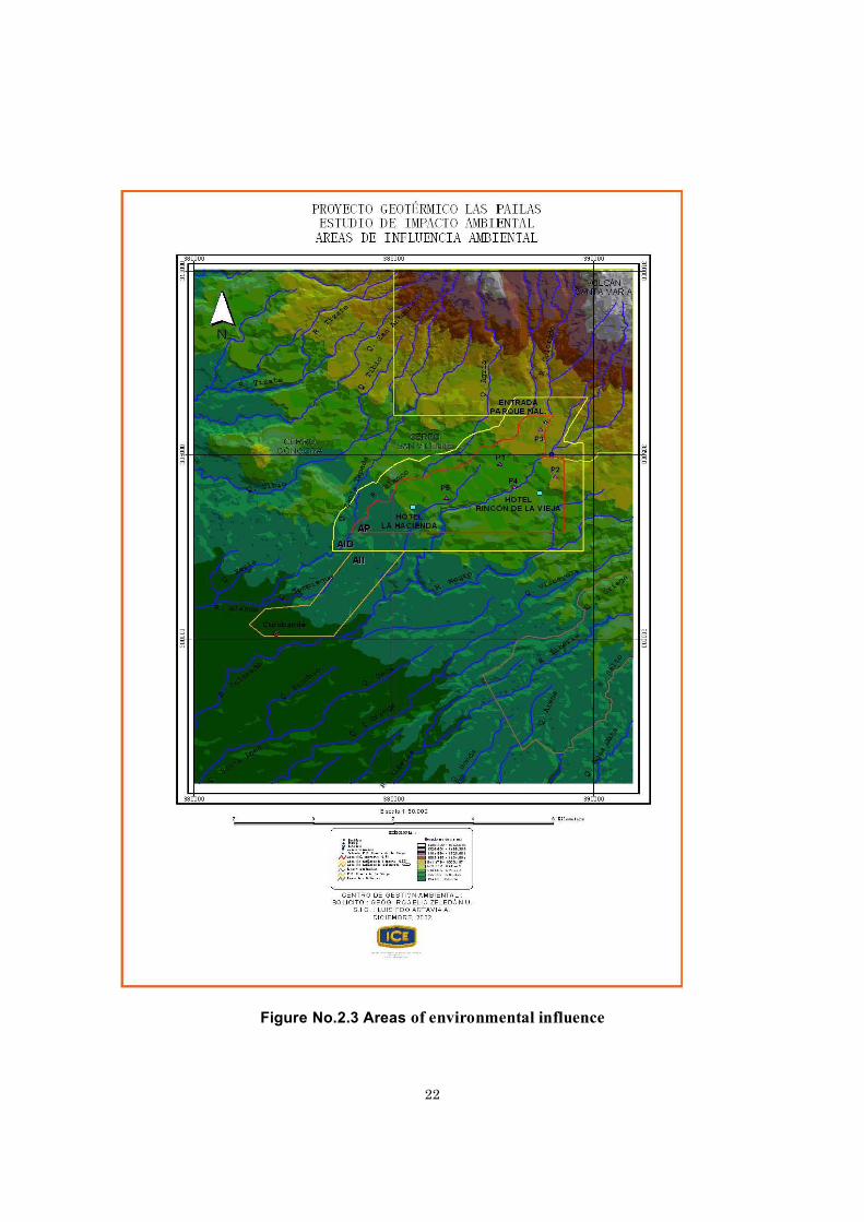
2.2.6 Areas of environmental influence
As indicated in SETENA’s “General Regulation on Procedures for Environmental Impact Evaluation (EIA),” from Monday, June 28, 2004, published in Gazette No. 125, these areas correspond to the geographical spaces that are affected themselves by the openings or activities or which sustain direct or indirect impact from the project.
For the case of the Las Pailas Geothermal Project the areas of environmental influence are the following: (Figure No. 2.3)
Project area (PA): This is the area that is affected by the project construction, covering the civil works: Provisional installations, platforms, accesses, geothermal fluid conductors (lagoons, pipes, vapor ducts, and separating stations), roads, machine hall, substation, workshops, offices and warehouses. Its approximate size is 2.5 Km
2.
A geothermal development, unlike other conventional electricity generating modalities, allows the land under development to be used for other purposes, such as agricultural, forest-related, protective, and tourism; for that reason the property area is not net, but total, because the property is larger than the work space.
Area of influence of the project area: This will correspond to the geographical space that could sustain direct impact during the construction and operation phases of the Project. This extends in a 500 m wide strip around the PA periphery. Its approximate size is 1.87 km
2.
Adjacent to the project is the National de la Vieja Volcano Park, and a small portion of this strip of land will be within the park grounds.
22
Figure No.2.3 Areas of environmental influence

23
CHAPTER 3. DESCRIPTION OF THE SURROUNDINGS
3.1 PHYSICAL ENVIRONMENT
3.1.1 Water Resources
The area of environmental influence of the project area is shared by the following microbasins: Blanco River, Colorado River, Victoria stream and Negro River, their beds are in order from 1 to 3, present a radial drainage pattern, parallel.
They are mountain rivers or torrents, their drainage area up to the exit from the geothermal exploration site is respectively: 24.03 Km
2, 24.09 Km
2, 3.34 Km
2and 26.66 Km
2, these last
3 start out as a single one from the area of influence referred to as the Colorado River.
From these, the micro-basin of the Victoria stream should stand out, because despite its small size, approximately 50% of the deep wells that have already been drilled are located there, and there are also a series of springs coming out of it whose waters are used to supply the potable water of the Hotel La Hacienda Lodge. The Curubandé water inlet is located on the right margin of a dam located in the Victoria Stream.
The volumes of water at the entrance of the Blanco and Colorado Rivers at the project area are 0.44 m3/s and 0.93 m3/s respectively; the first river at the project area exit doubles its average current (0.98 m3/s), in the case of the Colorado River the increase in current is almost 3 times as great (2.5 m3/s) because it includes the waters of the Negro River and the Victoria Stream.
In general these area waters have a “crystalline” or transparent appearance in the greater part of the year; however, they are not fit for human use because they tend to be acidic and infused with sulfate, when they mix with water from the thermo-mineral springs that flourish around their river beds.
With respect to the chemical quality of the rainwater, in the last 2 years a campaign to take samples in the project's area of environmental influence has taken place, and their pH values are listed between the registered parameters, whose averages oscillate between the range of 5.2 (close to PGP 02) and 6.0 (Curubandé center).
Blanco River: This borders the project on the northwestern sector. This site has a very rocky substrate, abundant current and the presence of a large amount of debris can be observed. The transparency of its waters is worth noting. Large rocks also stand out, as does the absence of vegetation on the shores. The forest that surrounds the river bed is mainly deciduous.
Colorado River: This cuts through the project at the lower part flowing southwest. Here one can observe a substrate formed from large rocks and flat areas covered with a large

24
amount of algae, as well as a small amount of debris. The river presents an abundant current point. The forest around it presents mainly deciduous vegetation.
3.1.2 Air Resources
Air quality: During the normal operation of geothermal plants, non-condensable gasses are produced, which are released into the atmosphere. Of this type of gasses, those that are important because of their effects, whether on the environment or on people's health, are carbon dioxide (CO
2) and hydrogen sulfide (H
2S).
Carbon dioxide (CO2): CO
2is a gas that is naturally found in the atmosphere, is odorless
and has an acidic taste. In high concentrations it produces mental confusion, headache and finally loss of consciousness, and it can even cause death from alteration of pH in the blood.
Hydrogen Sulfide (H2S): H
2S is a poisonous gas that like CO
2is found in the air from
natural sources such as volcanoes, fumaroles and decomposing organic material. H2S in
low concentrations causes negative effects in flora. In humans it causes eye watering, irritation of the nasal mucous membrane, and affects vision because of its effects on the corneas, and in very high concentrations it can cause death.
Noise: To date the sites of interest have been identified from the point of view of noise impact for the health of humans or the most vulnerable to being affected by changes in the levels of sound pressure within the three areas of environmental influence of the project. In these sites an intensive campaign has been mounted to measure the noise levels, which consisted of taking measurements at each of the sites three times a day (in the morning, noon, and night hours).
The sites chosen for execution of the noise measurement were the following: Administrative facilities of the National Park Volcán Rincón de la Vieja (outside), Hotel Rincón de la Vieja (inside –outside), street in front of the platform of Well # 1, adjacent natural forest area, Hotel Hacienda Guachipelin (inside – outside the installations), and the park in the urban center of the Curubandé community.
The sound was measured in decibels dB – (A), a unit that represents the level of sound pressure from noise obtained with a sound level meter, in interaction and with an A weighing filter, simulating the way in which it is perceived by the human ear.
3.1.3 EARTH RESOURCES
25
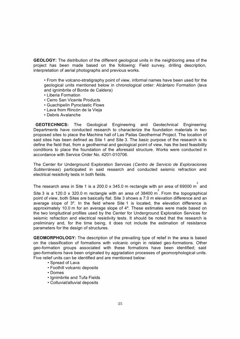
GEOLOGY: The distribution of the different geological units in the neighboring area of the project has been made based on the following: Field survey, drilling description, interpretation of aerial photographs and previous works.
• From the volcano-stratigraphy point of view, informal names have been used for the geological units mentioned below in chronological order: Alcántaro Formation (lava and ignimbrite of Borde de Caldera) • Liberia Formation • Cerro San Vicente Products • Guachipelín Pyroclastic Flows • Lava from Rincón de la Vieja • Debris Avalanche
GEOTECHNICS: The Geological Engineering and Geotechnical Engineering Departments have conducted research to characterize the foundation materials in two proposed sites to place the Machine hall of Las Pailas Geothermal Project. The location of said sites has been defined as Site 1 and Site 3. The basic purpose of the research is to define the field that, from a geothermal and geological point of view, has the best feasibility conditions to place the foundation of the aforesaid structure. Works were conducted in accordance with Service Order No. 4201-010706.
The Center for Underground Exploration Services (Centro de Servicio de Exploraciones Subterráneas) participated in said research and conducted seismic refraction and electrical resistivity tests in both fields.
The research area in Site 1 is a 200.0 x 345.0 m rectangle with an area of 69000 m2
and Site 3 is a 120.0 x 320.0 m rectangle with an area of 38400 m
2. From the topographical
point of view, both Sites are basically flat. Site 3 shows a 7.0 m elevation difference and an average slope of 3º. In the field where Site 1 is located, the elevation difference is approximately 10.0 m for an average slope of 4º. These estimates were made based on the two longitudinal profiles used by the Center for Underground Exploration Services for seismic refraction and electrical resistivity tests. It should be noted that the research is preliminary and, for the time being, it does not include the estimation of resistance parameters for the design of structures.
GEOMORPHOLOGY: The description of the prevailing type of relief in the area is based on the classification of formations with volcanic origin in related geo-formations. Other geo-formation groups associated with these formations have been identified; said geo-formations have been originated by aggradation processes of geomorphological units. Five relief units can be identified and are mentioned below:
• Spread of Lava• Foothill volcanic deposits• Domes• Ignimbrite and Tufa Fields• Colluvial/alluvial deposits

26
SOIL: In the area of Las Pailas GP, the soil map of Costa Rica (Acón y Asociados, 1989) presents Entisol, Inceptisol and Alfisol soils. The Entisol Concept makes reference to soils that have low development of genetic processes in the future. Most of them have no future development. In the area under study, Entisol soils classified as Lithic Ustrothent and Typic Ustipsaments are reported (Acón y Asociados, 1989). These soils mainly have thick textures which can vary from moderate to medium in thickness, and even be moderately thin, with brownish, olive-brown to brown-yellow color on the surface and brownish-gray in the subsurface.
RISKS:
VOLCANOLOGY: The historical activity of Rincón de la Vieja goes back to Colonial times and has been characterized by regular concentrated eruptions in the main crater with water vapor emissions, sulphurous gases and intra-crater fumaroles (exhaling activity).
In 1765 a brief and dubious reference was made about an eruption. In August 1863 a short eruption was recorded. Eruptions occurred in June 1912 similar to those that had occurred in 1863 (rivers had a milky white color for several days). Strong strombolian-type vapor emissions and ash columns occurred between April and June, 1922, with an activity similar to the previous eruption, with a lot of pyroclasts and impact craters.Vapor emissions and a strong fumarole activity were described until 1955. Then, on June 29, 1963 a constant emission of vapor clouds was reported from the active crater.
SEISMICITY: Seismicity in the region of Guanacaste province where Las Pailas Geothermal Project is located is characterized, like the rest of the country, by the periodical occurrence of earthquakes and a high seismicity rate. Several earthquakes at a regional scale have been historically recorded, originated from local faults or subduction of the Coco Plate under the Caribbean Plate, such as the earthquakes of 1911, 1916, 1935, 1941, 1950 and 1973. Calderic structures located in the Guanacaste Mountain Range may be considered another important source of seismic activity (Barquero et al., 2003).
RURAL AREAS: The rural area has a landscape in constant natural and anthropic evolution. Said evolution has been slow because modifying agents are natural causes, such as geological or geomorphological processes; in some other cases, man is the modifying agent with hotel activities and the change in the use of land, from woods to pastureland. This evolution is verified in space and time by the result in the diversity of landscapes.
3.2. BIOTIC ENVIRONMENT
LIFE ZONES: The following life zones are located in the area of influence of Las Pailas Geothermal Project: Based on field work and the Ecologic Map of Costa Rica, based on the Life Zone Classification System of L.R. Holdridge, CCT / 1993: Tropical Rainforest Mountain Range (transition to Tropical Basal) (bh-P) and Tropical Rainforest (transition to Mountain Range) (bh-T ∆).
VEGETATION COVERAGE: Zeledón et al (2002) contains a detailed description of this area in aspects such as Geology, Geomorphology, Life Zones, Hydrology, Soil, Rains,

27
Elevation, Use of Soil, Roads, and Human Settlements.
In the plots under study each tree was entered in the inventory: First, their botanic species was determined, their normal diameter was measured with a diameter tape, their commercial height was established and, finally, their total height was estimated. In scrubland and pastures no sample plots were established but all plant species were counted and their level of abundance was considered.
FAUNA DIVERSITY: The existing wood remains in the area of influence of the project have a few hectares and have survived because they contain springs used by the residents of Curubandé and the hotels Guachipelín and Rincón de la Vieja Lodge. That has helped the development of varied fauna diversity, favored by the proximity to Parque Nacional Rincón de la Vieja (PNRV).

28
CHAPTER 4SOCIAL AND CULTURAL ENVIRONMENT
This Chapter includes environmental issues related to human groups and their relevant spaces and activities which, in a way or another, will be primarily and/or secondarily related to the construction and operation of Las Pailas Geothermal Project in Las Pailas area of Rincón de la Vieja Volcano, in the Guanacaste volcanic mountain range.
From a social point of view, this particular Geothermal Project offers no major complications since its construction area is located approximately 12 km away from the Curubandé community (which is located 12 km away from Liberia city), which is thenearest community (Picture 4.1).
Tourism could be included, but because of the presence of Parque Nacional Rincón de la Vieja, this activity is mainly focused on two hotels that are isolated from the rest of the immediate social environment, within the land on which the GP will be built, through the payment of a toll to access the Guachipelín area.
Picture 4.1 Las Pailas Geothermal Project Environment. Curubandé, Liberia
Methodology to define the areas of social influence: The following aspects were considered:
• Legal regulations• Environmental policy of the ICE• Geothermal backgrounds of Miravalles, Bagaces• Prospecting background of the geothermal power potential in Las Pailas• Size of the works to be carried out (Vapor ducts, separators, machine hall,
coolers, etc.)• Construction phase, type and duration of the works
29
• Operation phase and duration of the GP• Maintenance actions during the operation of the Project• Access to the construction site From Bagaces and from Liberia through the
cemetery• Transportation needs of workers and goods• Proximity to the settlement• Hotel areas and installed capacity• Tourist attractions and visitors• Project Camp• Goods and services supply for residents and migrants• Employment capacity of the Project
4.1 HISTORICAL BACKGROUND OF CURUBANDÉ
As it was observed, Curubandé was defined as the only settlement within the area of influence for the probable construction-operation of a power generation project that would use the geothermal resources in Las Pailas zone.
In connection with the creation of the Curubandé settlement, a monograph prepared by initiative of the School of Curubandé (Escuela de Curubandé) states:
“The community of Curubandé was created in 1870. This region was made up of vacant lots owned by the government. The first owner appeared ten years later…” (Monograph, 2001)
As regards the relevance of the area, the monograph states: “… these lands were part of the district of Cañas Dulces. It is considered that, due to the cattle raising activity, colonization of this zone was slowly achieved; cattle herding was carried out between La Cueva farm and Guachipelín farm, covering these territories; farm workers engaging in this activity observed the possibility to settle with their families in these lands. The first residents come from the nearby town of Cañas Dulces.” (Monograph, 2001) The thoroughfare was colonized and Curubandé was thus created.
Reference material indicate that La Cueva estate was always an important center of economic activity, whose relationship was always stronger with the side of Cañas Dulces, although during the peak of said activity, workers came from Santa Cruz or Cañas. Therefore, its influence was important in the immediate environment, within which the area that would be later known as Curubandé settlement was located. According to data collected, by 1937 the relationship between the communities of Cañas Dulces and Curubandé had strengthened.
The monograph says that: “During the administration of Daniel Oduber Quiroz, 1974-1978, through the management conducted by the Representative and Prof. Asdrúbal Ocampo, Curubandé became the fifth district of Liberia with its villages Cereceda, El Gallo, Rodeito, Las Delicias and Colorado. As for the name Curubandé, the aforesaid Monograph

30
indicates that: “The origin of name of Curubandé is still unknown; however, there are two hypotheses: The name could be attributed to cattle raising activity; a pasture field had that name: Curubandé, and the community was named after it. Others have another opinion that seems to have more credibility: in the Pre-Columbian era the region was inhabited by indigenous people; there was an enclosed area in this zone and its family organization had a cacique called Curubandé; it is believed that this situation gave the name to the settlement.” (See Picture 4.2)
Picture 4.2 Center of Curubandé, in Liberia
In the study of the Ministry of Planning and Development (MIDEPLAN) titled “Indicadores Socioeconómicos Distritales de 1999” (1999 District Socioeconomic Indicators), this District had 1478 residents and was the least populated and smallest of the 5 districts.
It had 80.8 k2 for a density of 18.3 inhabitants per km2. In elementary school, 87.8% of
first-year students passed to the following school year, a percentage higher than that of Liberia, Cañas Dulces and Nacascolo and only lower than that of Mayorga. The general mortality rate was the lowest of the villages. The district had 97.4% electricity coverage.
According to the 2000 Census of Population and Housing, this District had 1812 inhabitants scattered through the entire area.

31
In the document “Cálculo de población por provincia, cantón y distrito al 1 de julio 2004” (Population estimate per province, village and district as of July 1, 2004) prepared by the INEC, the entire district of Curubandé reports 1952 inhabitants: 993 men and 959 women.
In general terms, it is a zone economically dominated by a large estate in the middle of which there are two hotels: Hacienda Guachipelín and Rincón de la Vieja Lodge. The Agriculture Development Institute (IDA, in Spanish) intervened in turn, assigning some plots to a group of less than 20 residents, but the quality of the lands assigned, as well as the predominant lands in the area, are not fit for crops.
However, it is a community necessarily visited/used by national and foreign tourists (mainly) staying at those hotels and visiting Parque Nacional del Volcán Rincón de la Vieja. But that is a comparative advantage that the community is not yet in position to benefit from as a strength or opportunity for development.
In connection with the possible construction of Las Pailas GP, the only concern shown in Curubandé would be related to the supply of drinking water, the main intake of which is superficially fed by the flow of Victoria Stream, which crosses the PA at the highest part.
However, according to inquires made at the office of the Land Registry in the Municipality, there are no restrictions in the Conservation Area of Guanacaste because the GP is located outside of Parque Nacional Rincón de la Vieja.
Urban regulations on the use of land and land planning in force in the Municipality of Liberia, set forth by the Regulatory Plan, are exclusively destined to strictly urban areas. The remaining lands are handled as rural zones, except for the district centers which have a residential use.

32
CHAPTER 5 ENVIRONMENTAL MANAGEMENT PLAN
The Environmental Management Plan is divided by areas (environment elements) that were analyzed in the Environmental Impact Study, including the impact, mitigation measures, actions to be implemented, schedule, officers in charge and cost.
The main elements of the environment that are analyzed in the Environmental Management Plan (EMP) are as follows:
Geomorphology:Change in microrelief due to the presence of the project works; therefore, the design of the project works must be readjusted to the current topography of the area.
In addition, changes in the behavior of runoff due to changes in the microrelief; therefore, there must be a way to handle water in excavations and material storage with sedimentary traps.
Soil / Oil and Fuel Spills Maintenance of the soil ecology; therefore, oil traps must be built and must be duly controlled to handle spills, as well as storage places and proper use of fuels. To such ends, the Rules on the Regulation of Hydrocarbon Storage and Trade System must be complied with (Decree No. 30131-MINAE-S).
Surface and Runoff WaterInstall materials with permeable granular base in ground and pedestrian walking surfaces allowing installation thereof. Install ditches, drain boxes, sewers, sidewalks. Use material with permeable granular base around the different works, entrances, parking, etc. And maintain physicochemical and biological control of the water in Negro and Colorado Rivers.
Gas Emissions In general, comply with the provisions set forth in the Official Gazette No. 236 of December 6, 1999 on Decree No. 28280-MOPT-MINAE-S, related to the Regulations for the control and technical review of polluting gas emissions coming from motor vehicles; furthermore, establish a protocol for frequent measurement of the concentration of gas emitted by chimneys. The minimum frequency will be one time per month during the first year of operation, and on a quarterly basis thereafter.
Comply with the provisions of Decree No. 30221-S regarding emissions in the perimeter of the facility.
Air Temperature Distribute equipments so that hot points are located in the most concentrated possible manner, and heat-insulate all equipment if so allowed by their design, in accordance with the chosen technology.

33
Noise Contamination The equipment to be acquired shall guarantee that in the premises boundaries the noise does not exceed 45 dBA at any time of the day outside the nearest residence in the direct area of influence, given that the relevant mitigation measure is included in the design.
Landscape Change in the natural characteristics of the landscape due to the construction of civil works during the construction phase and the constant presence of civil works, such as the machine hall Complex and other specific and related works, lineal works and dump. Actions will include the installation of environmental information billboards, preparing the architectural design of the machine hall complex in harmony with the environment, planting grass around specific works, establishing and placing vegetal screens and painting the works with colors that are in harmony with the natural environment.
Social:Information about the project will be disclosed by means of talks, meetings, posters and murals, which will contain data on issues such as occupational health, employment safety, technical aspects of the project, environmental guidelines established by the ICE and aspects related to the handling of the archeological heritage. A particularly important issue to be taken into account would be the social behavior of workers. They should be requested to have a respectful and socially acceptable conduct, particularly in leisure time or breaks. These talks must be conducted at the beginning of the construction tasks. The ICE’s contribution to preserve the environment would be an issue to be adequately coordinated through the Project Manager in order to comply with the established environmental guidelines and generate as much as possible the participation of environmental programs with community organizations of the communities located nearby the Project.
Everyday Life or Social Dynamics
This aspect would be also clearly impacted as experience has shown in the construction of important works, in the event the Project is finally built. The presence of increasing groups of workers living in a camp or inserted in the community entails, though in a temporary manner, a series of alterations in everyday life caused by the aforesaid presence of workers cohabiting in the same space. About 1000 workers are expected to be present at some time in Las Pailas GP during 36 months.
The demand for goods and services (mainly during night hours) related to leisure and the use of free time increases; consumption of spirits would be the most demanded with possible consequences for migrants and local residents which need permanent prevention measures with residents and workers. An information and educational plan is recommended to reduce or mitigate possible impacts, provided that new workers are incorporated in the community before and after the construction of the project.
Basic Services

34
Evidently, the community of Curubandé has resolved the availability of these services and does not expect any impact, except for the availability of water resources. At present, the aqueduct feeds from a water intake in Quebrada Victoria, an influent stream of Colorado River. Said intake is located near the area where the Machine Hall of this GP would be built; for that reason, that intake would be probably affected. The intensity would be strong and the extension would be high. The persistence would be mild from a physical point of view, but the social impact would be significant.
On the other hand, given the chemical characteristics of water resources in the area, including water for consumption, the current water source has no sustainability guarantee over time. For that reason and to prevent possible negative impacts in a very sensitive issue, it would be advisable to move the intake serving Curubandé to the intake currently serving Liberia, or otherwise use some source from a spring of water existing in the northern hillside of Góngora hill. To such ends, the pipeline should be extended in the necessary section and should be coordinated with A and A (sic) pipelines of Liberia.
Attention should also be given to the access road to Curubandé due to the increase in vehicle circulation, as well as the condition and capacity of the primary school once the project is commenced.
Archeological Heritage
In order to protect the National Archeological Heritage, the environment manager shall ensure compliance with prevention, mitigation and compensation measures (survey, supervision of earth work in the machine hall, fencing of cemeteries in the land acquired by the ICE, moving Zapote petroglyph, awareness talks to the population) proposed in this document. These measures will be carried out during the construction phase of the project; in the case of the survey, it will be conducted prior to any earth work since an assessment and rescue of the archeological heritage can be derived from said study. In the event an assessment or rescue is needed, a research proposal should be submitted to the National Archeological Commission, an entity in charge of granting permits to carry out archeological researches in our country.
Flora Flora is one of the elements that must be considered in the EMP because it affects the entire project, such as pastures with isolated trees, scrublands, herbaceous vegetation and secondary woodland.
Fauna Fauna is important in the environmental assessment of the project; therefore, it is included in the EMP since the different activities and works of the project directly and indirectly affect insects, amphibious, reptiles, birds and mammals.
Substation Constant consideration must be given to the soil and landscape so as to avoid alteration of the environment; furthermore, adequate cleaning, collection and treatment of solid waste and control of liquid and gas substances spillage will also be monitored.
35
Transmission Line: The Environmental Management Plan of Las Pailas Geothermal Project contains recommendations or corrective measures that will help reducing, eliminating or compensating the effects derived from the construction of the transmission line, as well as responsible actions and costs of the activity. It should be noted that some of the corrective measures have been already contemplated in the design of the project. The components thereof are as follows:
i. Geomorphology The application of ordinary construction measures applied to this type of works (such as the design of the access entrance, sewage, debris handling, final cleaning of the sites, etc.) lower the impact on geomorphology to highly acceptable levels in the transmission line works.
ii. Soil To install the transmission towers, access roads must be improved and/or created, which require cuts in the land. To mitigate the impact, roads must be designed considering safety angles of slope and inclinations in the existing land.
Likewise, surface runoff water should be channeled to decrease the process of water erosion; in the event erosion occurs, crossing canalization should be placed to cut runoff water. The excavation material must be placed in dump sites previously selected.
iii. Vegetation Given that during the construction of the transmission line some trees must be pruned throughout the layout of the line, tree genetic material should be planted in the project region. Other similar projects have considered planting 5 trees per each tree removed.
Trees must not be cut at the vegetation ground level within the easement if it is determined that it is herbaceous vegetation; if so, vegetation can be allowed to grow naturally.
During the transmission line works, the pruning of trees must be restricted to the amount strictly necessary, taking out the branches of trees that, due to their location or size, do not represent a serious threat to the transmission line integrity. As in current times, the prohibition to extract vegetal material from the corridor by personnel associated with the construction and maintenance of this work will continue in force.
In evaluating the need to cut trees or branches from a tree threatening to fall down, the following measures will be taken into account: a. The direction of predominant winds; b. The orientation of the relief (slope); c. The location of tree branches (form of the crown); d. The maximum known height for the species.
Within the line, herbaceous and bush vegetation shall be respected as much as possible if it does not exceed the allowed height limits, based on the design conditions of the transmission line to comply with safety rules in force.

36
iv. Fauna Although it has been determined that the fauna will not be affected by the project, it is important to point out that it is not allowed to capture birds present in the project site by workers building the transmission line; the same is applicable to the hunting of mammal species present in the region, such as squirrels, rabbits, wolves and armadillos.
Electrocution of birds standing on the transmission lines occurs by contact with two conductors or, more frequently, by simultaneous contact with a conductor and the post or tower. Good results are achieved with certain measures such as isolating of brackets, insulators or conductors, and the protection of structures.
Whenever possible, a section of the conductor is isolated or elements are modified in the structure, increasing their dimensions.
The most obvious measure to mitigate birds and airplane collision risks is to place signs on the cables to increase their visibility. In this sense, it has been proved that the measures applied by electric power companies, such as installing spirals (30 cm diameter) and neoprene strips (35 cm long) are recommended to reduce birds’ mortality.
v. Landscape It is advisable to reforest the boundary of the easement in three strata, using local species, selecting low-growing vegetation to reduce the risk of flashovers. As a general measure, the burning of construction residues, bags and waste, etc. endangering the present habitats should be prohibited.
All construction residues should be removed; any waste material should be transported to a nearby dump site for final disposal.
vi. Socioeconomics a) Furnish detailed information to residents of the area of influence on the following aspects: Commencement of the construction works; Size of the works; National and regional advantages of the new transmission system; Problems that will arise during the construction period. b) Maintain updated information in connection with electromagnetic fields and health studies. This measure responds to the fact that it is a controversial issue that may come up at any time. c) Maintaining an alert attitude in the event of any communication of concern in the community so as to address it and maintain a prevailing harmonious mood at the time the study is to be carried out. This task may be entrusted to the environmental manager. d) Address the community’s concerns detected or notified to the ICE in a fast and timely manner. e) Place danger signs in the towers since they will transport high-voltage energy.
In terms of the construction, operation and maintenance of these transmission lines, three phases must be considered: Assembly, operation and maintenance:
• Assembly of the Transmission Line: The following should be taken into account in this phase of the project:

37
a. Earth Works. b. Reconditioning and construction of road infrastructure. c. Alteration of the landscape due to the construction of the transmission line works. d. Local change of the use of land. e. Changes in the drainage micro-network. f. Low vegetation throughout the corridor. g. Changes in fauna habitats. h. Changes in the quality of life of the population.
• Operation of the Transmission Line: a. Increase in noise pollution. b. Changes in the micro drainage. c. Increase in the risk for landslides. d. Changes in the structure and composition of the vegetation under the TL. e. Increase in the risk for collision of birds. f. Increase in local electromagnetic fields.
• Maintenance of the Transmission Line: During this phase, the most important measures for the local and immediate environment are as follows: a. Control of the vegetation in the corridor of the easement b. Maintenance and control of access roads
5.1. ORGANIZATION OF THE ENVIRONMENTAL MANAGEMENT
Environmental management is the mechanism for the implementation of the different recovery, restitution, mitigation, prevention and compensation programs mentioned in the Environmental Management Plan, and to carry out the adjustments in the detailed design phase, based on the observations of the environmental inspection done by the executing unit of the ICE and SETENA.
This section contains minimum functional environmental specifications, which shall be monitored during the construction and operation of Las Pailas Geothermal Project, as well as some specifications that extend to the operation and maintenance of the geothermal power plant (Production).
These specifications describe the activities seeking to prevent, mitigate or compensate the potential impacts that may occur on environmental components of the projects’ area of influence due to the construction, operation and maintenance thereof.
The environmental management programs shall be adjusted during the detailed engineering phase of the project, maintaining the functional specifications and efficiencies of the different systems, and they shall be implemented during the construction and operation phases.
According to the Environmental Management Plan (EMP) an Environment Manager should be appointed and kept to execute and monitor the functionality and progress of each work, plan and program of the Environmental Management Plan and other

38
measures contemplated by the National Environmental Technical Secretariat (SETENA, in Spanish) or those arising during the construction and operation of the project.
Periodical reports must be submitted about the environmental engineering progress, problems and solutions adopted in coordination with the environmental inspection department of the ICE, according with the Costa Rican legal framework.
Goals of the Environmental Management of the Project:♦ Execute the environmental management plan of the project materialized in the measures,
works design, construction procedures and supplementary programs.
♦ During the execution of the works of the project, ensure compliance with the environmental rules included in the environmental impact study and the specifications thereof, as well as environmental laws and regulations issued by competent Environmental Authorities.
♦ Act as a fundamental tool of awareness management, not only of internal personnel but also of the ICE, as well as to identify environmental problems not initially considered inthe Environmental Management Plan, and propose and implement solutions for them.
5.2 MONITORING AND FOLLOW-UP PLAN
The Monitoring and Follow-up Plan is part of the general inspection of the project and comprise a set of activities for the control and follow-up of the execution of the Environmental Management Plan for the development of the construction, installation and operation of Las Pailas Geothermal Project.
The main goals of the environmental monitoring and follow-up or inspection are as follows: - Monitor the compliance with the environmental management plan of the project materialized in the management measures, works design, construction procedures and supplementary programs. - Carry out a systematic follow-up of the programs included in the environmental management plan. Evaluate and record the relevant recommendations for improvement thereof.
- Control compliance with the regulations established for the prevention and preservation of the environment and the natural resources issued by competent environmental authorities.
- Participate with the Project Manager in the management of relationships with external entities and authorities in charge of the supervision of the environmental project, elaborate reports on the progress of the project and the environmental management.
- Establish mechanisms for immediate response to deviations in the behavior of altered ecosystems due to project activities, not only in the construction phase but also in the operation phase.

39
- Identify environmental and social problems not initially considered in the environmental impact study, arising out of the construction of the project, and take all necessary steps so as to find appropriate solutions.
- Demand and certify the necessary evidence to verify the efficiency and effectiveness of all the systems and environmental control measures needed for the construction and operation activities.
- Design and implement test and reception protocols for each environmental management subprogram.
- Prepare periodical reports for the general inspection and project management departments, informing on a quarterly basis about the compliance, problems, adjustments and progress of the Environmental Management Plan.
- Under no circumstance shall the Environment Manager be responsible for monitoring and following up, carrying out management tasks and activities that contradict or make the works of the project redundant.
In terms of the Las Pailas area, no element or natural process is observed or detected that voids the environmental feasibility of a geothermal power development of the small dimensions described herein; furthermore, the surrounding elements would be benefited rather than being affected, since the activities are parallel and nonexclusive, and have been incorporated to geothermal developments in other regions of the world, such as in Italy, the United States, Japan, Indonesia, Mexico and other countries. (See chart No. 5.1 to see a detail description of the environmental management plan).

Chart No. 5.1 Environmental Management Plan for the construction and operation of Las Pailas Geothermal Project. ICE.
Environmental element
Impact Mitigation, prevention, compensation
Action Schedule Those responsible
Cost ($)
BIOPHYSICAL Geomorphology -Surface runoff
because of microrelief variation
-Surface drainage, water management
Avoid accumulation, mounds and surface drainage
Construction GP Las Pailas Director
2500
Geomorphology -Microrelief change for Project work
-Inspect the excavations when the work has finished -Stabilize and place in the grass block or pinto peanut plant bank or other suitable material
Re-vegetate with native plants and trees from the area in banks and shoulders immediately after the bank takes shape
At the same time as the construction phase of the GP Las Pailas
Environmental Manager of the GP Las Pailas
5000
Geomorphology -Alteration of the behavior of the run-off to be changed in the microrelief
Excavation water management and gathering of material with sedimentary traps
Apply the best surface water management practices including drains, sewage system, ditches, junction box, slope stabilization and energy dissipaters
During the construction of the project
Environmental Manager of the GP Las Pailas
4700
Landscape/Tourism
-Obstruction of the road to the Volcán Rincón de la Vieja National Park because of traffic flow and construction.
Create and put up informative ecological billboards about: 1. Construction 2. Geothermal work that is of interest to tourists
1. Create and put up an informative ecological billboard Section 6.1.6.1 2. Publicize the importance and meaning of the geothermal work that is of interest to tourists as well as its components, though an informative billboard. Section 6.1.6.1
1. Starting from the beginning of the deconstruction stage 2. Immediately after finishing the construction, it should be made permanent during its operation
Project Director
4000 Put up at least 2 informative ecological billboards (see attached proposal 5)
Landscape -Change in the nature of the landscape due to the presence of a machine hall and related detailed work
1. Architectural design of the machine hall in harmony with the environment 2. Establish and place a plant screen on the northwest side of the machine hall 3. Establish and place a plant screen around the machine hall4. Lay turf on the area around the construction
1. Design the construction work with sturdy glass walls with mirrored film to reflect natural surroundings Section 6.1.6.22. Set up a 600 m plant screen of tall grass on the northwest side of the machine hall (on the edge of the road to the Rincón de la Vieja Volcano), property of ICE Section 6.1.6.3. 3. Plant trees and shrubs around the four sides of the machine hall Section 6.1.6.2, Fig. 14. Lay turf in the open spaces around the construction Section 6.1.6.3.c
1. Design Stage, C. S. Design and Manager of construction 2. Prior to construction, if it is the dry season wait until the rainy season to set up the screen (it should only remain during the construction period) 3. and 4. Immediately following the construction period.
Project Director 1. Included in the C.S. Design budget
2, 3 and 4,
3000
Landscape -Change in thenature of the landscape because of dumpsites
1. Design in harmony with the geomorphologic surroundings 2. Re-vegetate the dumpsites
1. The final design of the dumpsites should be in harmony with the current geomorphologic surroundings, before they are formed. 2. Plant vegetation in the dumpsites Section 6.1.6.4.a.
1. Design Stage 2. Immediately after completing the formation of the dumpsites
Project Director 200/ha (estimated 1000)
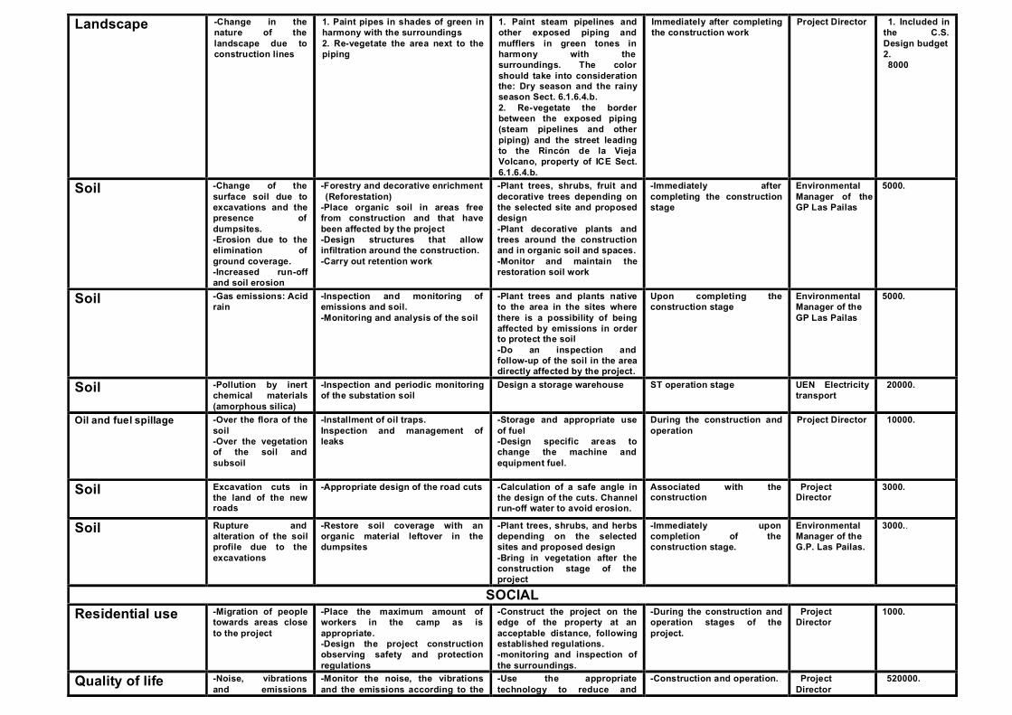
Landscape -Change in the nature of the landscape due to construction lines
1. Paint pipes in shades of green in harmony with the surroundings 2. Re-vegetate the area next to the piping
1. Paint steam pipelines and other exposed piping and mufflers in green tones in harmony with the surroundings. The color should take into consideration the: Dry season and the rainy season Sect. 6.1.6.4.b. 2. Re-vegetate the border between the exposed piping (steam pipelines and other piping) and the street leading to the Rincón de la Vieja Volcano, property of ICE Sect. 6.1.6.4.b.
Immediately after completing the construction work
Project Director 1. Included in the C.S. Design budget 2. 8000
Soil -Change of the surface soil due to excavations and the presence of dumpsites. -Erosion due to the elimination of ground coverage.-Increased run-off and soil erosion
-Forestry and decorative enrichment (Reforestation)
-Place organic soil in areas free from construction and that have been affected by the project -Design structures that allow infiltration around the construction. -Carry out retention work
-Plant trees, shrubs, fruit and decorative trees depending on the selected site and proposed design -Plant decorative plants and trees around the construction and in organic soil and spaces. -Monitor and maintain the restoration soil work
-Immediately after completing the construction stage
Environmental Manager of the GP Las Pailas
5000.
Soil -Gas emissions: Acid rain
-Inspection and monitoring of emissions and soil. -Monitoring and analysis of the soil
-Plant trees and plants native to the area in the sites where there is a possibility of being affected by emissions in order to protect the soil -Do an inspection and follow-up of the soil in the area directly affected by the project.
Upon completing the construction stage
Environmental Manager of the GP Las Pailas
5000.
Soil -Pollution by inert chemical materials (amorphous silica)
-Inspection and periodic monitoring of the substation soil
Design a storage warehouse ST operation stage UEN Electricity transport
20000.
Oil and fuel spillage -Over the flora of the soil -Over the vegetation of the soil and subsoil
-Installment of oil traps. Inspection and management of leaks
-Storage and appropriate use of fuel -Design specific areas to change the machine and equipment fuel.
During the construction and operation
Project Director 10000.
Soil Excavation cuts in the land of the new roads
-Appropriate design of the road cuts -Calculation of a safe angle in the design of the cuts. Channel run-off water to avoid erosion.
Associated with the construction
Project Director
3000.
Soil Rupture and alteration of the soil profile due to the excavations
-Restore soil coverage with an organic material leftover in the dumpsites
-Plant trees, shrubs, and herbs depending on the selected sites and proposed design -Bring in vegetation after the construction stage of the project
-Immediately upon completion of the construction stage.
Environmental Manager of the G.P. Las Pailas.
3000..
SOCIAL Residential use -Migration of people
towards areas close to the project
-Place the maximum amount of workers in the camp as is appropriate. -Design the project construction observing safety and protection regulations
-Construct the project on the edge of the property at an acceptable distance, following established regulations. -monitoring and inspection of the surroundings.
-During the construction and operation stages of the project.
Project Director
1000.
Quality of life -Noise, vibrations and emissions
-Monitor the noise, the vibrations and the emissions according to the
-Use the appropriate technology to reduce and
-Construction and operation. Project Director
520000.
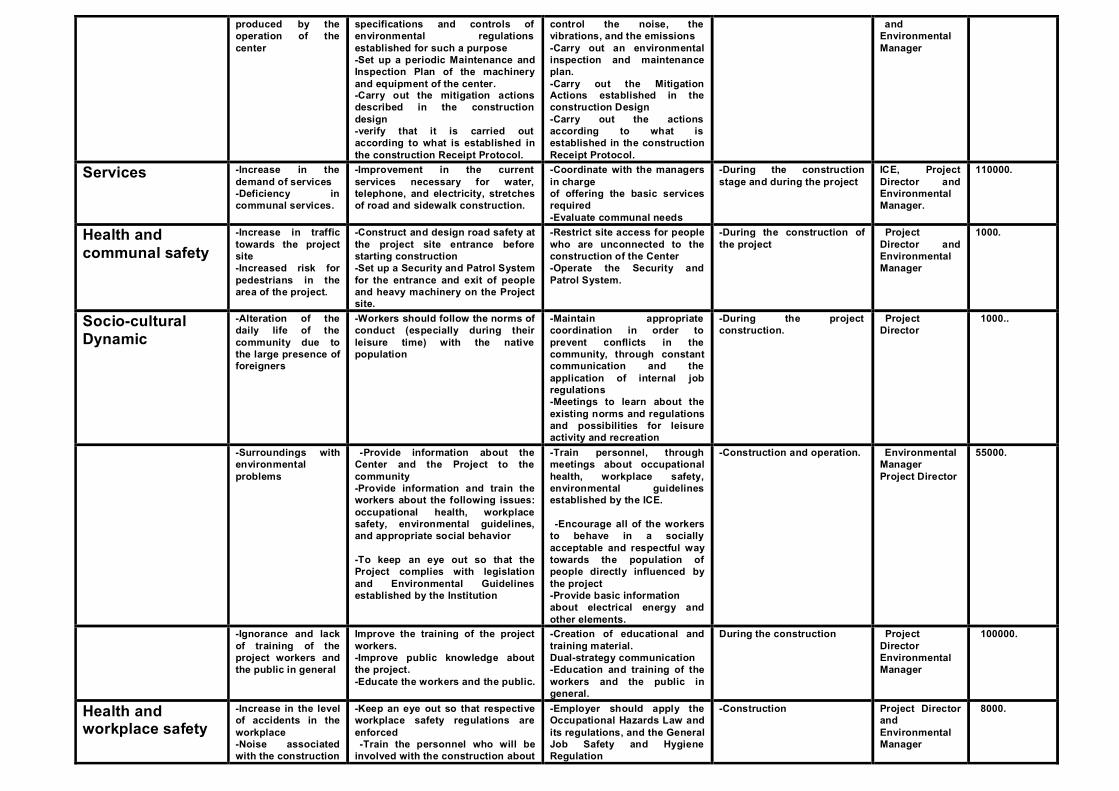
produced by the operation of the center
specifications and controls of environmental regulations established for such a purpose -Set up a periodic Maintenance and Inspection Plan of the machinery and equipment of the center. -Carry out the mitigation actions described in the construction design -verify that it is carried out according to what is established in the construction Receipt Protocol.
control the noise, the vibrations, and the emissions -Carry out an environmental inspection and maintenance plan. -Carry out the Mitigation Actions established in the construction Design -Carry out the actions according to what is established in the construction Receipt Protocol.
and Environmental Manager
Services -Increase in the demand of services -Deficiency in communal services.
-Improvement in the current services necessary for water, telephone, and electricity, stretches of road and sidewalk construction.
-Coordinate with the managers in charge of offering the basic services required-Evaluate communal needs
-During the construction stage and during the project
ICE, Project Director and Environmental Manager.
110000.
Health and communal safety
-Increase in traffic towards the project site -Increased risk for pedestrians in the area of the project.
-Construct and design road safety at the project site entrance before starting construction -Set up a Security and Patrol System for the entrance and exit of people and heavy machinery on the Project site.
-Restrict site access for people who are unconnected to the construction of the Center -Operate the Security and Patrol System.
-During the construction of the project
Project Director and Environmental Manager
1000.
Socio-cultural Dynamic
-Alteration of the daily life of the community due to the large presence offoreigners
-Workers should follow the norms of conduct (especially during their leisure time) with the native population
-Maintain appropriate coordination in order to prevent conflicts in the community, through constant communication and the application of internal job regulations -Meetings to learn about the existing norms and regulations and possibilities for leisure activity and recreation
-During the project construction.
Project Director
1000..
-Surroundings with environmental problems
-Provide information about the Center and the Project to the community -Provide information and train the workers about the following issues: occupational health, workplace safety, environmental guidelines, and appropriate social behavior
-To keep an eye out so that the Project complies with legislation and Environmental Guidelines established by the Institution
-Train personnel, through meetings about occupational health, workplace safety, environmental guidelines established by the ICE.
-Encourage all of the workers to behave in a socially acceptable and respectful way towards the population of people directly influenced by the project -Provide basic information about electrical energy and other elements.
-Construction and operation. Environmental Manager Project Director
55000.
-Ignorance and lack of training of the project workers and the public in general
Improve the training of the project workers. -Improve public knowledge about the project. -Educate the workers and the public.
-Creation of educational and training material.Dual-strategy communication -Education and training of the workers and the public in general.
During the construction Project Director Environmental Manager
100000.
Health and workplace safety
-Increase in the level of accidents in the workplace -Noise associated with the construction
-Keep an eye out so that respective workplace safety regulations are enforced -Train the personnel who will be
involved with the construction about
-Employer should apply the Occupational Hazards Law and its regulations, and the General Job Safety and Hygiene Regulation
-Construction Project Director and Environmental Manager
8000.

workplace safety before the construction is started.
-Use the appropriate job safety equipment
Employment -Increase in job offers in the area
-Prioritize the hiring of local workers -Publicize the true requirements of the required labor force as well as the transient nature of the labor.
-During the construction stages of the project
Project Director
1000.
Value of the property
-Increase in the value of the land
Periodically update the costs of the property
Anticipate future extensions and their respective costs
Construction/ Operation
ICE, Valuation 1000.
Archaeological Heritage
Alterations of possible archeological sites due to earth works during the construction stage
Complete an archeological survey of the places where the project will be constructed. This should be done before any earth works or removal of vegetation.
It is necessary to hire a professional archeologist. This work includes field, laboratory, and office work
This work can last 2 months (construction stage)
Project Director and Environmental Manager
3400
-Earth works supervision in the area where the machine hall will be installed.
Hiring of an archeologist during the removal of vegetation and earth works
Construction Stage: The estimated time is fifteen days
Project Director and Environmental Manager
670
-Place a barbed wire fence with concrete posts in the funerary-type archeological sites existing in the land that the project is expected to acquire.
Assign a work crew and purchase of materials (posts, wire, cramp irons)
Once the land is acquired by the ICE
-Project Director and Environmental Manager
4720
Transfer of the Zapote petroglyph to a place (machine hall) that has the adequate conditions for its protection and conservation
Construction of an open hut with a cement foundation, wood posts and imitation tile roof or according to the project design. This place shall have an explanatory plate. Hiring of a restorer for cleaning and conservation work.
During the construction of the machine hall
-Project Director and Environmental Manager
9000
Raise awareness in the Curubandé population about archeological resources.
3 meetings or workshops directed towards children, teenagers and adults will be given.
During the construction stage
Project Director Environmental Manager
1000.
FLORA Vegetation -Vegetation removal
in road entrances -Tree removal
-Re-vegetation of herbs and shrubs along roads, banks, and shoulders.-Tree reforestation and maintenance for the first 2 years.
-Land protection for efficient natural and induced regeneration.
Start of the rainy season Project Director. Those responsible
2.000.
Forest coverage -Impact on plant coverage -Impact on green hedges
-Maintain herbal vegetation on the project site -reforestation of available project areas
Reforest the project land or other land, according to what is needed.
Start of the rainy season Project Director. Those responsible
11500.
Forest coverage (dumpsites)
Existence of dumpsites in vegetation-filled areas.
-Design the dumpsite appropriately with its respective shoulders, banks, drainage, and deposit material. -Compacting and leveling design.
-Coordinate the parts of the project construction that require land removal and leveling.-Create a plan to put the removed material
Construction Project Director and Environmental Manager
50000
Forest coverage (Waste)
-Production of organic and inorganic waste
Complete the Waste Management Plan according to what is described in the section on waste in chapter 2 of this study.
-Implement the was te management plan during the project construction
Construction Project Director and Environmental Manager
75000
Forest coverage Impact due to the presence of forest
-Create a fire prevention and control plan
-Implement the fire prevention and control plan.
Construction Project Director and
67000

(Fires) fires that put the project construction in danger
-Control and monitor those areas that are at risk
Environmental Manager
FAUNA Flora and Fauna -Bird and plant
removal -Prohibition and limitation of hunting and removal of wild species.
Environmental education for the workers.
At the start of the construction
Project Director Those responsible
1000.
Bird fauna -Bird collision -Bird distracters, checking, and monitoring
-Placement of distracting signals
Associated with the construction
Project Director Those responsible
3000.
Soil, fauna, flora and water
-Pollution from generation of solid waste from homes or the construction
-Management and regulation of solid waste in authorized dumpsites
-Stacking of packaging material and of domestic waste prior to the selection and transport of waste to the dumpsite
Start of the work and during the construction and operation stage
Project Director. Those
responsible
15000.
Soil, fauna, flora and water (Installations)
Impact due to the presence of temporary project installations
Design a plan to recover the sites occupied by the temporary installations, preserving and improving the surroundings
Create a dismantling program coordinated with the end of the project to avoid looking like an abandonment.
Upon the completion of the construction
Project Director Those responsible
6000
Land and water fauna
-Spillage of oil and fuel on aquatic fauna -On aquatic vegetation -On land fauna -On water pollution
-Installment of oil traps. -Inspection and management of leaks -Establishment of an area for oil changes and vehicle maintenance-Regenerate appropriate habitats through reforestation. -Stabilize the affected area -appropriate maintenance and inspection of the surroundings (physical-chemical monitoring)
-Installment of monitoring and maintenance equipment. -Inspection of the equipment and machine cleaning areas -Construct oil storage sites and regulations.-Design environmental education programs -Make appropriate arrangements for oil waste and create a culture of protection and improvement of the surroundings -Periodical monitoring of equipment and machinery and environmental follow-up: -Physical-chemical and hydrological monitoring of streams and rivers-Periodic monitoring of the equipment and machine maintenance waste
-Construction and operation. Project Director. Those responsible
30000.
WATER Surface Water and run-off
-Reduction of the infiltration rate of water because of the waterproofing of covered surfaces
-Install material with a permeable granular base on load-bearing and pedestrian crossing surfaces where it is allowed.-Installation of ditches, drainage boxes, sewers, sidewalks.
-Use paving stones, grass, block, or other material with a permeable granular base around the construction, entrances, and parking areas. -Coordinate with the GP Las Pailas Director
During the construction Environmental Manager GP Las Pailas
8000.
Presence of perforated platforms in the project area
-Construct a mesh cyclone fence for the protection of the construction and of the surroundings. -Waterproofing of sludge pools. -Channeling of water and traps. Appropriate compacting, leveling and drainage in the land around the platforms
Appropriate design of the work next to the platform such as compacting, leveling, drainage, water channeling and waterproofing of the pools.
During the construction Environmental Manager GP Las Pailas
76600
SUBSTATION

Vegetation -Removal of the scrubland vegetation
Planting of green hedges along the access path of the garden
-Installation of shaped plants in the gardens and maintenance of green hedges
After the completion of ST and in the operation stage
Environmental Manager
1000.
Fauna -Collision of bird fauna and animal removal
-Protective measures for birds -Installation of screens and signs warning of the Prohibition of hunting.
ST construction and operation Project Director Those responsible
2500.
Soil and water -Transformer dielectric oil leak risk
-Design that acknowledges and eliminates this risk
-Appropriate design and implementation supervision
Standard existing design and construction
Project Director. Those responsible
1500.
Soil -Fuel and lubricant spillage
-Collection with absorbent materials (sawdust, sand etc.)
-Absorption of the spillage and removal from the ST area.
ST construction and operation stage
Project Director. Environmental Manager
1500.
ATMOSPHERE Air -Gas emissions -Carry out periodic measures of gas
emissions, at least once a month during the first year of operation and every three months starting in the second year when the plant needs to be in operation. -Coordinate the surveillance of plant workers’ health through medical work records. The check-up shall be done annually and will include hearing, blood, respiratory system, stress tests etc. among other things -Carry out according to the current regulations related to gas emissions and immissions,
-Select, adopt, and implement the most appropriate measures to monitor plant conditions with the available data and appropriate technology. -The selection of analysis methodology will be made by both the manufacturer and the operator and will be subject to the generation technology that is considered most appropriate. -Periodic monitoring in pre-established sites -Quarterly monitoring for H
2S
-Observance of the national environmental regulations related to emissions, and Decree No. 30221-S which refers to immissions, around the perimeter of the plant
Operation period of the plant GP Las Pailas UEN Production Environmental Manager
84000.
-Atmospheric quality vs. equipment testing
In carrying out equipment testing, particularly in the machine hall and during pipe bursts, there is a considerable amount of noise that normally results from the testing.
Inspection and monitoring during the testing
Construction/ operation
Project Director Environmental Manager
10000.
-Atmospheric quality vs. Fluid management
Fluid management is indispensible for the operation of the plant and requires carrying out a series of activities that produce noise in different areas of the plant.
-Inspection of fluid management
Construction/ operation
Project Director Environmental Manager
4200.
-Atmospheric quality vs. Plant Operation
To operate the geothermal plants, it is necessary to carry out a series of activities that cause the continual emission of gas into the atmosphere. Because of this, it is necessary to maintain controls in order to ensure that the emissions do not rise above the established limits to avoid harming people.
Inspection and periodic monitoring
Operation Project Director Environmental Manager
4000.
Air temperature -Rise in the local air temperature due to heat radiation
-Distribute the equipment in a way that the hottest points are placed together as close as possible. -Thermally isolate the equipment as much as the design allows
-Keep in contact with the plant staff making sure that they take the appropriate preventative measures. -Provide the staff with
Operation period of the plant GP Las Pailas UEN Production Occupational Health Unit
4000.
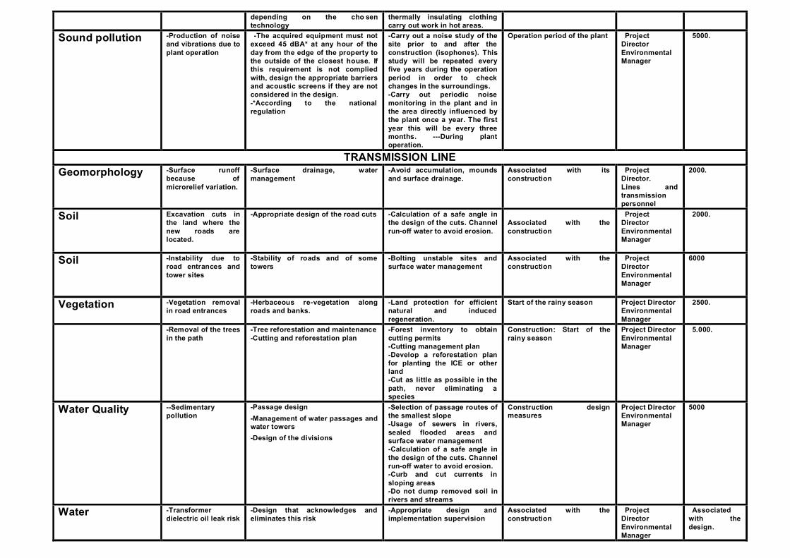
depending on the cho sen technology
thermally insulating clothing carry out work in hot areas.
Sound pollution -Production of noise and vibrations due to plant operation
-The acquired equipment must not exceed 45 dBA* at any hour of the day from the edge of the property to the outside of the closest house. If this requirement is not complied with, design the appropriate barriers and acoustic screens if they are not considered in the design. -*According to the national regulation
-Carry out a noise study of the site prior to and after the construction (isophones). This study will be repeated every five years during the operation period in order to check changes in the surroundings.-Carry out periodic noise monitoring in the plant and in the area directly influenced by the plant once a year. The firstyear this will be every three months. ---During plant operation.
Operation period of the plant Project Director Environmental Manager
5000.
TRANSMISSION LINE Geomorphology -Surface runoff
because of microrelief variation.
-Surface drainage, water management
-Avoid accumulation, mounds and surface drainage.
Associated with its construction
Project Director. Lines and transmission personnel
2000.
Soil Excavation cuts in the land where the new roads are located.
-Appropriate design of the road cuts -Calculation of a safe angle in the design of the cuts. Channel run-off water to avoid erosion.
Associated with the construction
Project Director Environmental Manager
2000.
Soil -Instability due to road entrances and tower sites
-Stability of roads and of some towers
-Bolting unstable sites and surface water management
Associated with the construction
Project Director Environmental Manager
6000
Vegetation -Vegetation removal in road entrances
-Herbaceous re-vegetation along roads and banks.
-Land protection for efficient natural and induced regeneration.
Start of the rainy season Project Director Environmental Manager
2500.
-Removal of the trees in the path
-Tree reforestation and maintenance-Cutting and reforestation plan
-Forest inventory to obtain cutting permits-Cutting management plan -Develop a reforestation plan for planting the ICE or other land-Cut as little as possible in the path, never eliminating a species
Construction: Start of the rainy season
Project Director Environmental Manager
5.000.
Water Quality --Sedimentary pollution
-Passage design -Management of water passages and water towers -Design of the divisions
-Selection of passage routes of the smallest slope -Usage of sewers in rivers, sealed flooded areas and surface water management-Calculation of a safe angle in the design of the cuts. Channel run-off water to avoid erosion. -Curb and cut currents in sloping areas -Do not dump removed soil in rivers and streams
Construction design measures
Project Director Environmental Manager
5000
Water -Transformer dielectric oil leak risk
-Design that acknowledges and eliminates this risk
-Appropriate design and implementation supervision
Associated with the construction
Project Director Environmental Manager
Associated with the design.
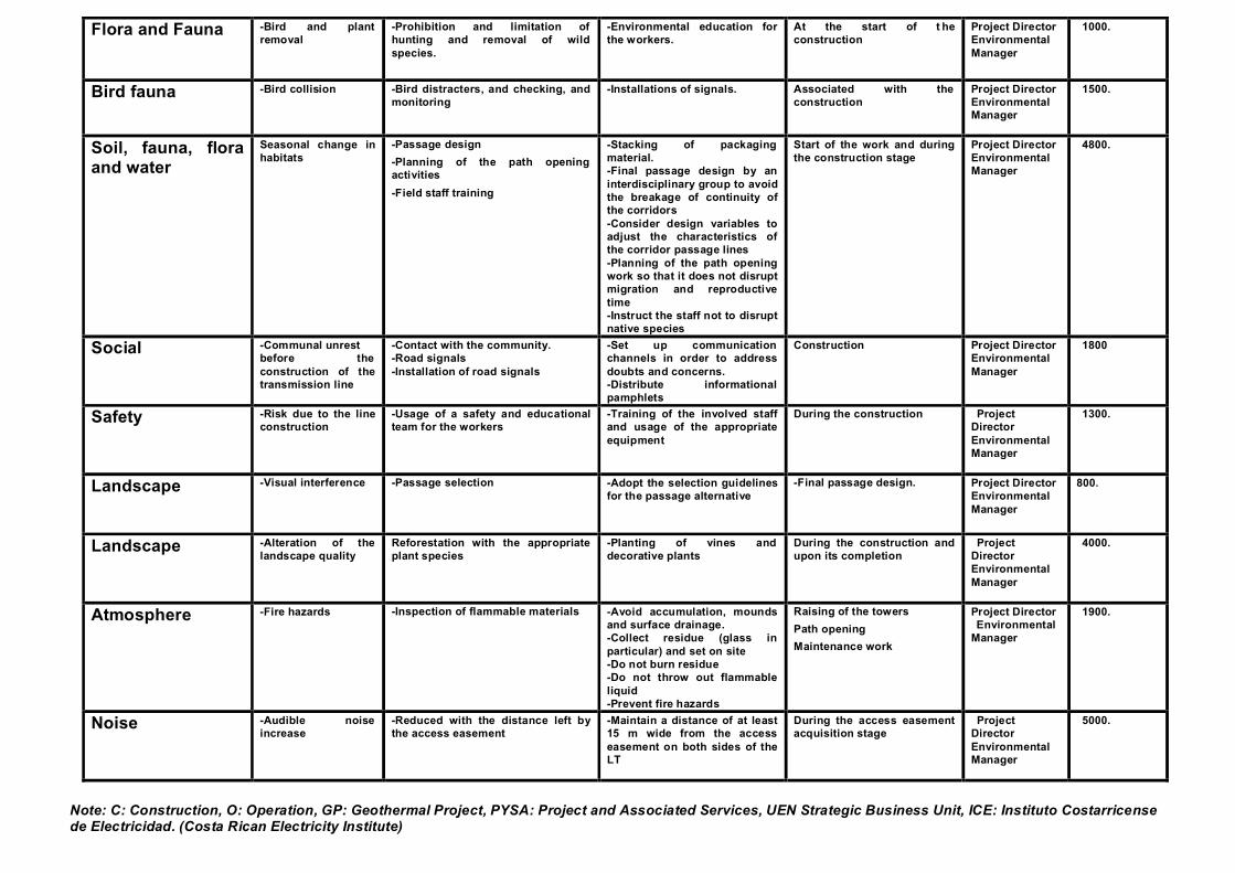
Flora and Fauna -Bird and plant removal
-Prohibition and limitation of hunting and removal of wild species.
-Environmental education for the workers.
At the start of t he construction
Project Director Environmental Manager
1000.
Bird fauna -Bird collision -Bird distracters, and checking, and monitoring
-Installations of signals. Associated with the construction
Project Director Environmental Manager
1500.
Soil, fauna, flora and water
Seasonal change in habitats
-Passage design -Planning of the path opening activities-Field staff training
-Stacking of packaging material. -Final passage design by an interdisciplinary group to avoid the breakage of continuity of the corridors -Consider design variables to adjust the characteristics of the corridor passage lines -Planning of the path opening work so that it does not disrupt migration and reproductive time-Instruct the staff not to disrupt native species
Start of the work and during the construction stage
Project Director Environmental Manager
4800.
Social -Communal unrest before the construction of the transmission line
-Contact with the community. -Road signals-Installation of road signals
-Set up communication channels in order to address doubts and concerns. -Distribute informational pamphlets
Construction Project Director Environmental Manager
1800
Safety -Risk due to the line construction
-Usage of a safety and educational team for the workers
-Training of the involved staff and usage of the appropriate equipment
During the construction Project Director Environmental Manager
1300.
Landscape -Visual interference -Passage selection -Adopt the selection guidelines for the passage alternative
-Final passage design. Project Director Environmental Manager
800.
Landscape -Alteration of the landscape quality
Reforestation with the appropriate plant species
-Planting of vines and decorative plants
During the construction and upon its completion
Project Director Environmental Manager
4000.
Atmosphere -Fire hazards -Inspection of flammable materials -Avoid accumulation, mounds and surface drainage. -Collect residue (glass in particular) and set on site -Do not burn residue -Do not throw out flammable liquid -Prevent fire hazards
Raising of the towers Path opening Maintenance work
Project Director Environmental
Manager
1900.
Noise -Audible noise increase
-Reduced with the distance left by the access easement
-Maintain a distance of at least 15 m wide from the access easement on both sides of the LT
During the access easement acquisition stage
Project Director Environmental Manager
5000.
Note: C: Construction, O: Operation, GP: Geothermal Project, PYSA: Project and Associated Services, UEN Strategic Business Unit, ICE: Instituto Costarricense de Electricidad. (Costa Rican Electricity Institute)