Embed Size (px)
Citation preview
STREAM INVENTORY REPORT Hely Creek
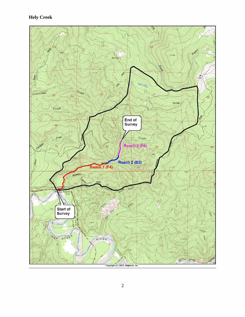
INTRODUCTION A stream inventory was conducted during June 5, 2006 to June 19, 2006 on Hely Creek. The survey began at the confluence with Van Duzen River and extended upstream 9,892 feet. The Hely Creek inventory was conducted in two parts: habitat inventory and biological inventory. The objective of the habitat inventory was to document the habitat available to anadromous salmonids in Hely Creek. The objective of the biological inventory was to document the presence and distribution of juvenile salmonid species. The objective of this report is to document the current habitat conditions and recommend options for the potential enhancement of habitat for Chinook salmon, coho salmon, and steelhead trout. Recommendations for habitat improvement activities are based upon target habitat values suitable for salmonids in California's north coast streams. WATERSHED OVERVIEW Hely Creek is a tributary to the Van Duzen River, tributary to the Eel River, tributary to the Pacific Ocean, located in Humboldt County, California (Map 1). Hely Creek's legal description at the confluence with Van Duzen River is T01N R02E S05. Its location is 40°29'56.0" north latitude and 123°58'34.0" west longitude, LLID number 1239760404988. Hely Creek is a second order stream and has approximately 5.83 miles of blue line stream according to the USGS Owl Creek and Redcrest 7.5 minute quadrangle. Hely Creek drains a watershed of approximately 3.65 square miles. Elevations range from about 216 feet at the mouth of the creek to 1,850 feet in the headwater areas (average elevation of headwaters, not highest point). Redwood and Douglas fir forest dominates the watershed. The watershed is entirely privately owned and is managed for timber production. Vehicle access exists via Highway 101 south of Fortuna to Highway 36 east; proceed about 11.5 miles east and turn left onto Redwood House Road. METHODS The habitat inventory conducted in Hely Creek follows the methodology presented in the California Salmonid Stream Habitat Restoration Manual (Flosi et al, 1998). The California Conservation Corps (CCC) Technical Advisors and Watershed Stewards Project/AmeriCorps (WSP) Members that conducted the inventory were trained in standardized habitat inventory methods by the California Department of Fish and Game (DFG). This inventory was conducted by a two-person team.
Hely Creek
2
Hely Creek
3
SAMPLING STRATEGY The inventory uses a method that samples approximately 10% of the habitat units within the survey reach. All habitat units included in the survey are classified according to habitat type and their lengths are measured. All pool units are measured for maximum depth, depth of pool tail crest (measured in the thalweg), dominant substrate composing the pool tail crest, and embeddedness. Habitat unit types encountered for the first time are measured for all the parameters and characteristics on the field form. Additionally, from the ten habitat units on each field form page, one is randomly selected for complete measurement. All pools except step-pools are fully sampled. HABITAT INVENTORY COMPONENTS A standardized habitat inventory form has been developed for use in California stream surveys and can be found in the California Salmonid Stream Habitat Restoration Manual. This form was used in Hely Creek to record measurements and observations. There are eleven components to the inventory form. 1. Flow: Flow is measured in cubic feet per second (cfs) near the bottom of the stream survey reach using a Marsh-McBirney Model 2000 flow meter. 2. Channel Type: Channel typing is conducted according to the classification system developed and revised by David Rosgen (1994). This methodology is described in the California Salmonid Stream Habitat Restoration Manual. Channel typing is conducted simultaneously with habitat typing and follows a standard form to record measurements and observations. There are five measured parameters used to determine channel type: 1) water slope gradient, 2) entrenchment, 3) width/depth ratio, 4) substrate composition, and 5) sinuosity. Channel characteristics are measured using a clinometer, hand level, hip chain, tape measure, and a stadia rod. 3. Temperatures: Both water and air temperatures are measured and recorded at every tenth habitat unit. The time of the measurement is also recorded. Both temperatures are taken in degrees Fahrenheit at the middle of the habitat unit and within one foot of the water surface. 4. Habitat Type: Habitat typing uses the 24 habitat classification types defined by McCain and others (1990). Habitat units are numbered sequentially and assigned a type identification number selected from a standard list of 24 habitat types. Dewatered units are labeled "dry". Hely Creek habitat typing used standard basin level measurement criteria. These parameters require that the minimum
Hely Creek
4
length of a described habitat unit must be equal to or greater than the stream's mean wetted width. All measurements are in feet to the nearest tenth. Habitat characteristics are measured using a clinometer, hip chain, and stadia rod. 5. Embeddedness: The depth of embeddedness of the cobbles in pool tail-out areas is measured by the percent of the cobble that is surrounded or buried by fine sediment. In Hely Creek, embeddedness was ocularly estimated. The values were recorded using the following ranges: 0 - 25% (value 1), 26 - 50% (value 2), 51 - 75% (value 3) and 76 - 100% (value 4). Additionally, a value of 5 was assigned to tail-outs deemed unsuited for spawning due to inappropriate substrate like bedrock, log sills, boulders or other considerations. 6. Shelter Rating: Instream shelter is composed of those elements within a stream channel that provide juvenile salmonids protection from predation, reduce water velocities so fish can rest and conserve energy, and allow separation of territorial units to reduce density related competition for prey. The shelter rating is calculated for each fully-described habitat unit by multiplying shelter value and percent cover. Using an overhead view, a quantitative estimate of the percentage of the habitat unit covered is made. All cover is then classified according to a list of nine cover types. In Hely Creek, a standard qualitative shelter value of 0 (none), 1 (low), 2 (medium), or 3 (high) was assigned according to the complexity of the cover. Thus, shelter ratings can range from 0-300 and are expressed as mean values by habitat types within a stream. 7. Substrate Composition: Substrate composition ranges from silt/clay sized particles to boulders and bedrock elements. In all fully-described habitat units, dominant and sub-dominant substrate elements were ocularly estimated using a list of seven size classes and recorded as a one and two, respectively. In addition, the dominant substrate composing the pool tail-outs is recorded for each pool. 8. Canopy: Stream canopy density was estimated using modified handheld spherical densiometers as described in the California Salmonid Stream Habitat Restoration Manual. Canopy density relates to the amount of stream shaded from the sun. In Hely Creek, an estimate of the percentage of the habitat unit covered by canopy was made from the center of approximately every third unit in addition to every fully-described unit, giving an approximate 30% sub-sample. In addition, the area of canopy was estimated ocularly into percentages of coniferous or hardwood trees. 9. Bank Composition and Vegetation: Bank composition elements range from bedrock to bare soil. However, the stream banks are usually covered with grass, brush, or trees. These factors influence the ability of stream banks to
Hely Creek
5
withstand winter flows. In Hely Creek, the dominant composition type and the dominant vegetation type of both the right and left banks for each fully-described unit were selected from the habitat inventory form. Additionally, the percent of each bank covered by vegetation (including downed trees, logs, and rootwads) was estimated and recorded. 10. Large Woody Debris Count: Large woody debris (LWD) is an important component of fish habitat and an element in channel forming processes. In each habitat unit all pieces of LWD partially or entirely below the elevation of bankfull discharge are counted and recorded. The minimum size to be considered is twelve inches in diameter and six feet in length. The LWD count is presented by reach and is expressed as an average per 100 feet. 11. Average Bankfull Width: Bankfull width can vary greatly in the course of a channel type stream reach. This is especially true in very long reaches. Bankfull width can be a factor in habitat components like canopy density, water temperature, and pool depths. Frequent measurements taken at riffle crests (velocity crossovers) are needed to accurately describe reach widths. At the first appropriate velocity crossover that occurs after the beginning of a new stream survey page (ten habitat units), bankfull width is measured and recorded in the appropriate header block of the page. These widths are presented as an average for the channel type reach. BIOLOGICAL INVENTORY Biological sampling during the stream inventory is used to determine fish species and their distribution in the stream. Fish presence was observed from the stream banks in Hely Creek. In addition, twelve sites were electrofished using a Smith-Root Model 12 electrofisher. These sampling techniques are discussed in the California Salmonid Stream Habitat Restoration Manual. DATA ANALYSIS Data from the habitat inventory form are entered into Stream Habitat 2.0.19, a Visual Basic data entry program developed by Karen Wilson, Pacific States Marine Fisheries Commission in conjunction with the California Department of Fish and Game. This program processes and summarizes the data, and produces the following ten tables:
• Riffle, Flatwater, and Pool Habitat Types • Habitat Types and Measured Parameters • Pool Types • Maximum Residual Pool Depths by Habitat Types • Mean Percent Cover by Habitat Type • Dominant Substrates by Habitat Type
Hely Creek
6
• Mean Percent Vegetative Cover for Entire Stream • Fish Habitat Inventory Data Summary by Stream Reach (Table 8) • Mean Percent Dominant Substrate / Dominant Vegetation Type for Entire Stream • Mean Percent Shelter Cover Types for Entire Stream
Graphics are produced from the tables using Microsoft Excel. Graphics developed for Hely Creek include:
• Riffle, Flatwater, Pool Habitat Types by Percent Occurrence • Riffle, Flatwater, Pool Habitat Types by Total Length • Total Habitat Types by Percent Occurrence • Pool Types by Percent Occurrence • Maximum Residual Depth in Pools • Percent Embeddedness • Mean Percent Cover Types in Pools • Substrate Composition in Pool Tail-outs • Mean Percent Canopy • Dominant Bank Composition by Composition Type • Dominant Bank Vegetation by Vegetation Type
HABITAT INVENTORY RESULTS * ALL TABLES AND GRAPHS ARE LOCATED AT THE END OF THE REPORT * The habitat inventory of June 5, 2006 to June 19, 2006 was conducted by B. Rahn and H. Sgalitzer (WSP) and T. Tollefson (DFG). The total length of the stream surveyed was 9,892 feet with an additional 402 feet of side channel. Stream flow was measured near the bottom of the survey reach with a Marsh-McBirney Model 2000 flowmeter at 2.145 cfs on June 12, 2006. Hely Creek is an F4 channel type for 6,509 feet of the stream surveyed (Reach 1), a B2 channel type for 1,625 feet of the stream surveyed (Reach 2) and an F6 channel type for 1,758 feet of the stream surveyed (Reach 3). F4 channels are entrenched, meandering, riffle/pool channels on low gradients with high width/depth ratios and gravel-dominant substrates. B2 channels are moderately entrenched with moderate gradients and riffle dominated channels with infrequently spaced pools. B2 channels have a very stable plan and profile with stable banks and boulder-dominant substrates. F6 channels are entrenched, meandering riffle/pool channels on low gradients with high width/depth ratios and silt/clay-dominant substrates. Water temperatures taken during the survey period ranged from 53 to 58 degrees Fahrenheit. Air temperatures ranged from 53 to 64 degrees Fahrenheit.
Hely Creek
7
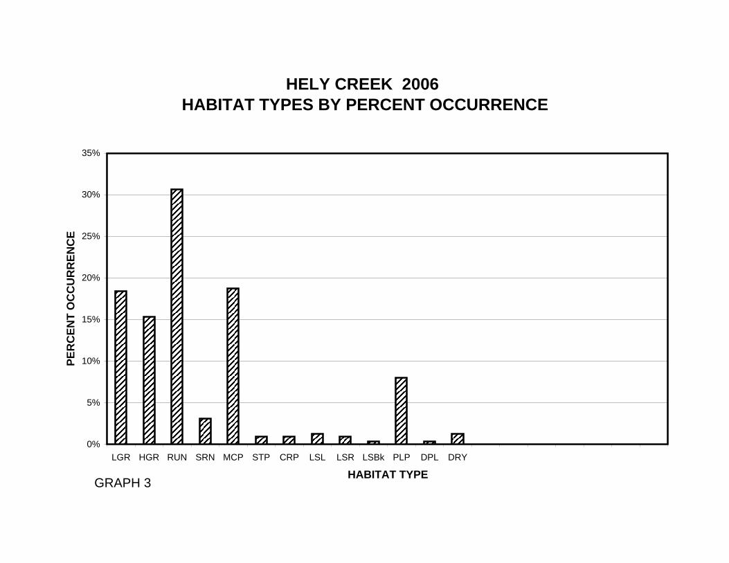
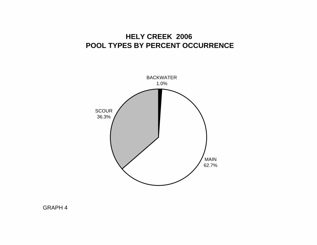
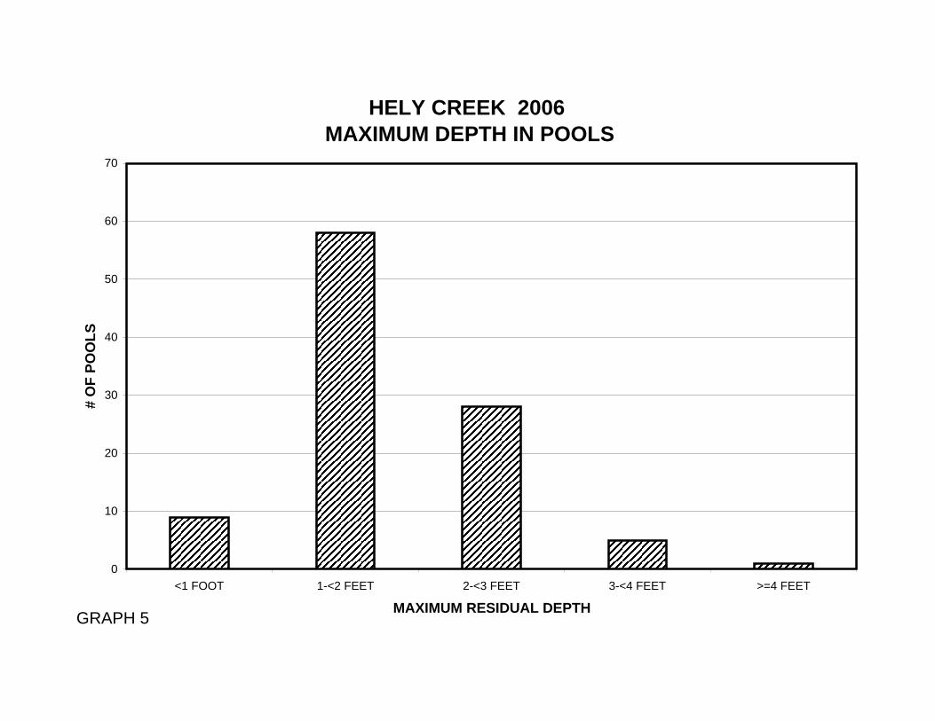
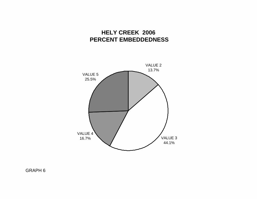
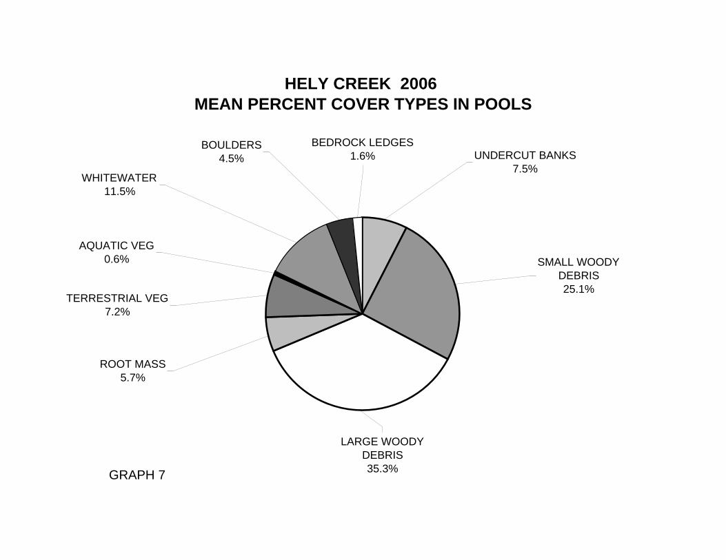
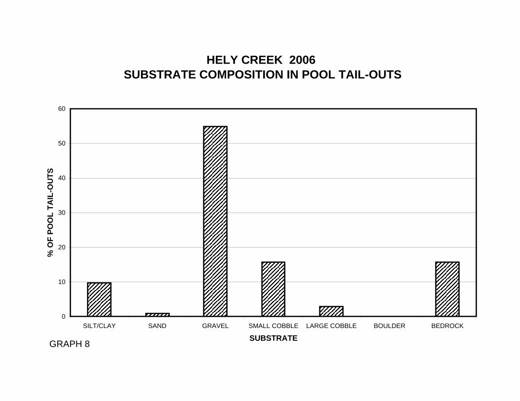
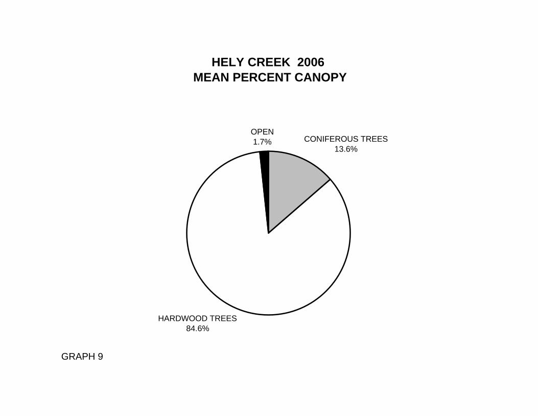
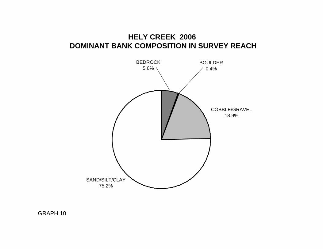
Table 1 summarizes the Level II riffle, flatwater, and pool habitat types. Based on frequency of occurrence there were 34% riffle units, 34% flatwater units, 31% pool units and 1% dry units (Graph 1). Based on total length of Level II habitat types there were 37% riffle units, 37% flatwater units, 23% pool units and 3% dry units (Graph 2). Thirteen Level IV habitat types were identified (Table 2). The most frequent habitat types by percent occurrence were 31% run units, 19% mid-channel pool units, 18% low gradient riffle units (Graph 3). Based on percent total length, there were 33% run units, 22% low gradient riffle units, and 16% high gradient riffle units. A total of 102 pools were identified (Table 3). Main channel pools were the most frequently encountered, at 63% (Graph 4), and comprised 66% of the total length of all pools (Table 3). Table 4 is a summary of maximum residual pool depths by pool habitat types. Pool quality for salmonids increases with depth. Thirty-four of the 101 pools (34%) had a residual depth of two feet or greater (Graph 5). The depth of cobble embeddedness was estimated at pool tail-outs. Of the 102 pool tail-outs measured, none had a value of 1, 14 had a value of 2 (13.7%); 45 had a value of 3 (44.1%); 17 had a value of 4 (16.7%) and 26 had a value of 5 (25.5%); (Graph 6). On this scale, a value of 1 indicates the best spawning conditions and a value of 4 the worst. Additionally, a value of 5 was assigned to tail-outs deemed unsuited for spawning due to inappropriate substrate such as bedrock, log sills, boulders, or other considerations. A shelter rating was calculated for each habitat unit and expressed as a mean value for each habitat type within the survey using a scale of 0-300. Riffle habitat types had a mean shelter rating of 54, flatwater habitat types had a mean shelter rating of 36, and pool habitats had a mean shelter rating of 92 (Table 1). Of the pool types, the main-channel pools had a mean shelter rating of 84, Scour pools had a mean shelter rating of 104, backwater pools had a mean shelter rating of 150 (Table 3). Table 5 summarizes mean percent cover by habitat type. Large woody debris is the dominant cover types in Hely Creek. Graph 7 describes the pool cover in Hely Creek. Large woody debris is the dominant pool cover type followed by small woody debris. Table 6 summarizes the dominant substrate by habitat type. Graph 8 depicts the dominant substrate observed in pool tail-outs. Gravel was observed in 55% of pool tail-outs and small cobble observed in 16% of pool tail-outs. The mean percent canopy density for the surveyed length of Hely Creek was 98%. Two percent of the canopy was open. Of the canopy present, the mean percentages of hardwood and coniferous trees were 86% and 14%, respectively. Graph 9 describes the mean percent canopy in Hely Creek. For the stream reach surveyed, the mean percent right bank vegetated was 92%. The mean percent left bank vegetated was 92%. The dominant elements composing the structure of the
Hely Creek
8
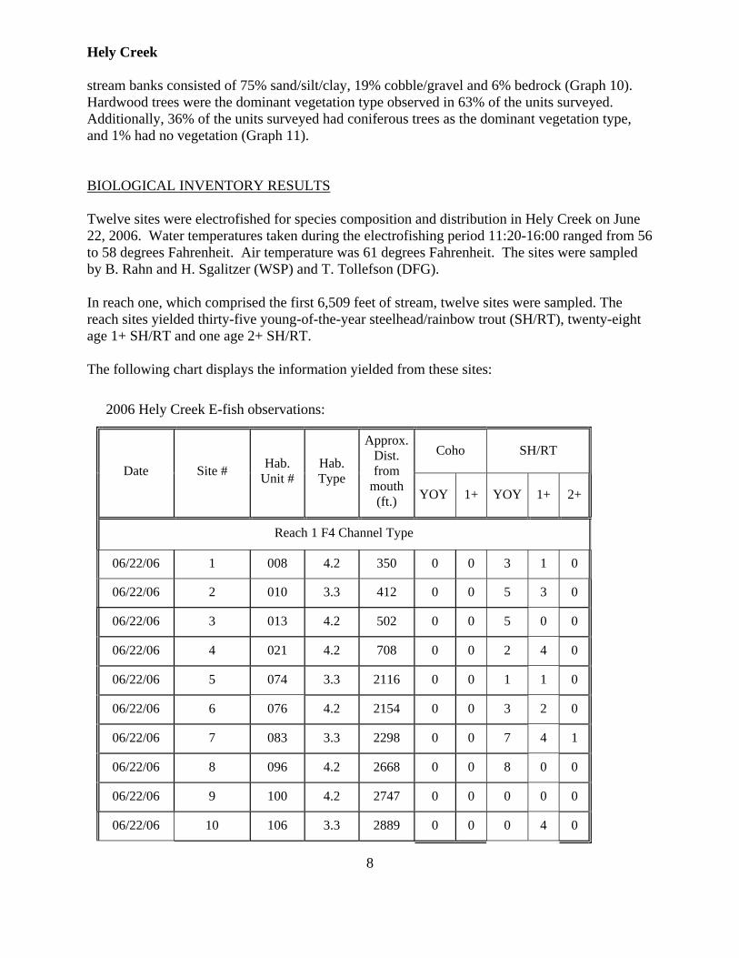
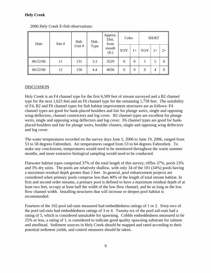
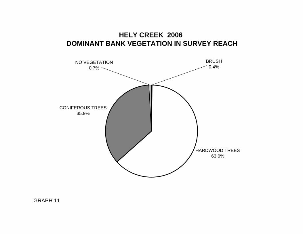
stream banks consisted of 75% sand/silt/clay, 19% cobble/gravel and 6% bedrock (Graph 10). Hardwood trees were the dominant vegetation type observed in 63% of the units surveyed. Additionally, 36% of the units surveyed had coniferous trees as the dominant vegetation type, and 1% had no vegetation (Graph 11). BIOLOGICAL INVENTORY RESULTS Twelve sites were electrofished for species composition and distribution in Hely Creek on June 22, 2006. Water temperatures taken during the electrofishing period 11:20-16:00 ranged from 56 to 58 degrees Fahrenheit. Air temperature was 61 degrees Fahrenheit. The sites were sampled by B. Rahn and H. Sgalitzer (WSP) and T. Tollefson (DFG). In reach one, which comprised the first 6,509 feet of stream, twelve sites were sampled. The reach sites yielded thirty-five young-of-the-year steelhead/rainbow trout (SH/RT), twenty-eight age 1+ SH/RT and one age 2+ SH/RT. The following chart displays the information yielded from these sites:
2006 Hely Creek E-fish observations:
Coho SH/RT Date Site # Hab.
Unit # Hab. Type
Approx. Dist. from
mouth (ft.) YOY 1+ YOY 1+ 2+
Reach 1 F4 Channel Type
06/22/06 1 008 4.2 350 0 0 3 1 0
06/22/06 2 010 3.3 412 0 0 5 3 0
06/22/06 3 013 4.2 502 0 0 5 0 0
06/22/06 4 021 4.2 708 0 0 2 4 0
06/22/06 5 074 3.3 2116 0 0 1 1 0
06/22/06 6 076 4.2 2154 0 0 3 2 0
06/22/06 7 083 3.3 2298 0 0 7 4 1
06/22/06 8 096 4.2 2668 0 0 8 0 0
06/22/06 9 100 4.2 2747 0 0 0 0 0
06/22/06 10 106 3.3 2889 0 0 0 4 0
Hely Creek
9
2006 Hely Creek E-fish observations:
Coho SH/RT Date Site # Hab.
Unit # Hab. Type
Approx. Dist. from
mouth (ft.) YOY 1+ YOY 1+ 2+
06/22/06 11 131 3.3 3529 0 0 1 5 0
06/22/06 12 150 4.4 4056 0 0 0 4 0
DISCUSSION Hely Creek is an F4 channel type for the first 6,509 feet of stream surveyed and a B2 channel type for the next 1,625 feet and an F6 channel type for the remaining 1,758 feet. The suitability of F4, B2 and F6 channel types for fish habitat improvement structures are as follows: F4 channel types are good for bank-placed boulders and fair for plunge weirs, single and opposing wing-deflectors, channel constrictors and log cover. B2 channel types are excellent for plunge weirs, single and opposing wing deflectors and log cover. F6 channel types are good for bank-placed boulders and fair for plunge weirs, boulder clusters, single and opposing wing deflectors and log cover. The water temperatures recorded on the survey days June 5, 2006 to June 19, 2006, ranged from 53 to 58 degrees Fahrenheit. Air temperatures ranged from 53 to 64 degrees Fahrenheit. To make any conclusions, temperatures would need to be monitored throughout the warm summer months, and more extensive biological sampling would need to be conducted. Flatwater habitat types comprised 37% of the total length of this survey; riffles 37%, pools 23% and 3% dry units. The pools are relatively shallow, with only 34 of the 101 (34%) pools having a maximum residual depth greater than 2 feet. In general, pool enhancement projects are considered when primary pools comprise less than 40% of the length of total stream habitat. In first and second order streams, a primary pool is defined to have a maximum residual depth of at least two feet, occupy at least half the width of the low flow channel, and be as long as the low flow channel width. Installing structures that will increase or deepen pool habitat is recommended. Fourteen of the 102 pool tail-outs measured had embeddedness ratings of 1 or 2. Sixty-two of the pool tail-outs had embeddedness ratings of 3 or 4. Twenty-six of the pool tail-outs had a rating of 5, which is considered unsuitable for spawning. Cobble embeddedness measured to be 25% or less, a rating of 1, is considered to indicate good quality spawning substrate for salmon and steelhead. Sediment sources in Hely Creek should be mapped and rated according to their potential sediment yields, and control measures should be taken.
Hely Creek
10
Seventy-two of the 102 pool tail-outs measured had gravel or small cobble as the dominant substrate. This is generally considered good for spawning salmonids. The mean shelter rating for pools was 92. The shelter rating in the flatwater habitats was 36. A pool shelter rating of approximately 100 is desirable. The amount of cover that now exists is being provided primarily by large woody debris in Hely Creek. Large woody debris is the dominant cover type in pools followed by small woody debris. Log and root wad cover structures in the pool and flatwater habitats would enhance both summer and winter salmonid habitat. Log cover structure provides rearing fry with protection from predation, rest from water velocity, and also divides territorial units to reduce density related competition. The mean percent canopy density for the stream was 98%. Reach 1 had a canopy density of 97.7%, Reach 2 had a canopy density of 99.1% and Reach 3 had a canopy density of 99.4%. The percentage of right and left bank covered with vegetation was 92% and 92%, respectively. In areas of stream bank erosion planting endemic species of coniferous and hardwood trees, is recommended. RECOMMENDATIONS 1) Hely Creek should be managed as an anadromous, natural production stream. 2) The limited water temperature data available suggest that maximum temperatures are
within the acceptable range for juvenile salmonids. To establish more complete and meaningful temperature regime information, 24-hour monitoring during the July and August temperature extreme period should be performed for 3 to 5 years.
3) Where feasible, design and engineer pool enhancement structures to increase the number
of pools. This must be done where the banks are stable or in conjunction with stream bank armor to prevent erosion.
4) There are several log debris accumulations present on Hely Creek that are retaining large
quantities of fine sediment. The modification of these debris accumulations is desirable, but must be done carefully, over time, to avoid excessive sediment loading in downstream reaches.
5) Inventory and map sources of stream bank erosion and prioritize them according to
present and potential sediment yield. Identified sites should then be treated to reduce the amount of fine sediments entering the stream.
6) Active and potential sediment sources related to the road system need to be identified,
mapped, and treated according to their potential for sediment yield to the stream and its tributaries.
Hely Creek
11
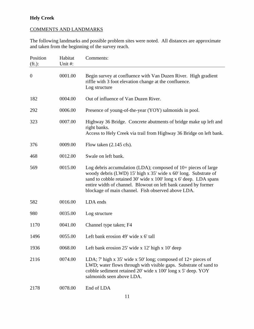
COMMENTS AND LANDMARKS The following landmarks and possible problem sites were noted. All distances are approximate and taken from the beginning of the survey reach. Position Habitat Comments: (ft.): Unit #: 0 0001.00 Begin survey at confluence with Van Duzen River. High gradient
riffle with 3 foot elevation change at the confluence. Log structure 182 0004.00 Out of influence of Van Duzen River. 292 0006.00 Presence of young-of-the-year (YOY) salmonids in pool. 323 0007.00 Highway 36 Bridge. Concrete abutments of bridge make up left and
right banks. Access to Hely Creek via trail from Highway 36 Bridge on left bank. 376 0009.00 Flow taken (2.145 cfs). 468 0012.00 Swale on left bank. 569 0015.00 Log debris accumulation (LDA); composed of 10+ pieces of large
woody debris (LWD) 15' high x 35' wide x 60' long. Substrate of sand to cobble retained 30' wide x 100' long x 6' deep. LDA spans entire width of channel. Blowout on left bank caused by former blockage of main channel. Fish observed above LDA.
582 0016.00 LDA ends 980 0035.00 Log structure 1170 0041.00 Channel type taken; F4 1496 0055.00 Left bank erosion 49' wide x 6' tall 1936 0068.00 Left bank erosion 25' wide x 12' high x 10' deep 2116 0074.00 LDA; 7' high x 35' wide x 50' long; composed of 12+ pieces of
LWD; water flows through with visible gaps. Substrate of sand to cobble sediment retained 20' wide x 100' long x 5' deep. YOY salmonids seen above LDA.
2178 0078.00 End of LDA
Hely Creek
12
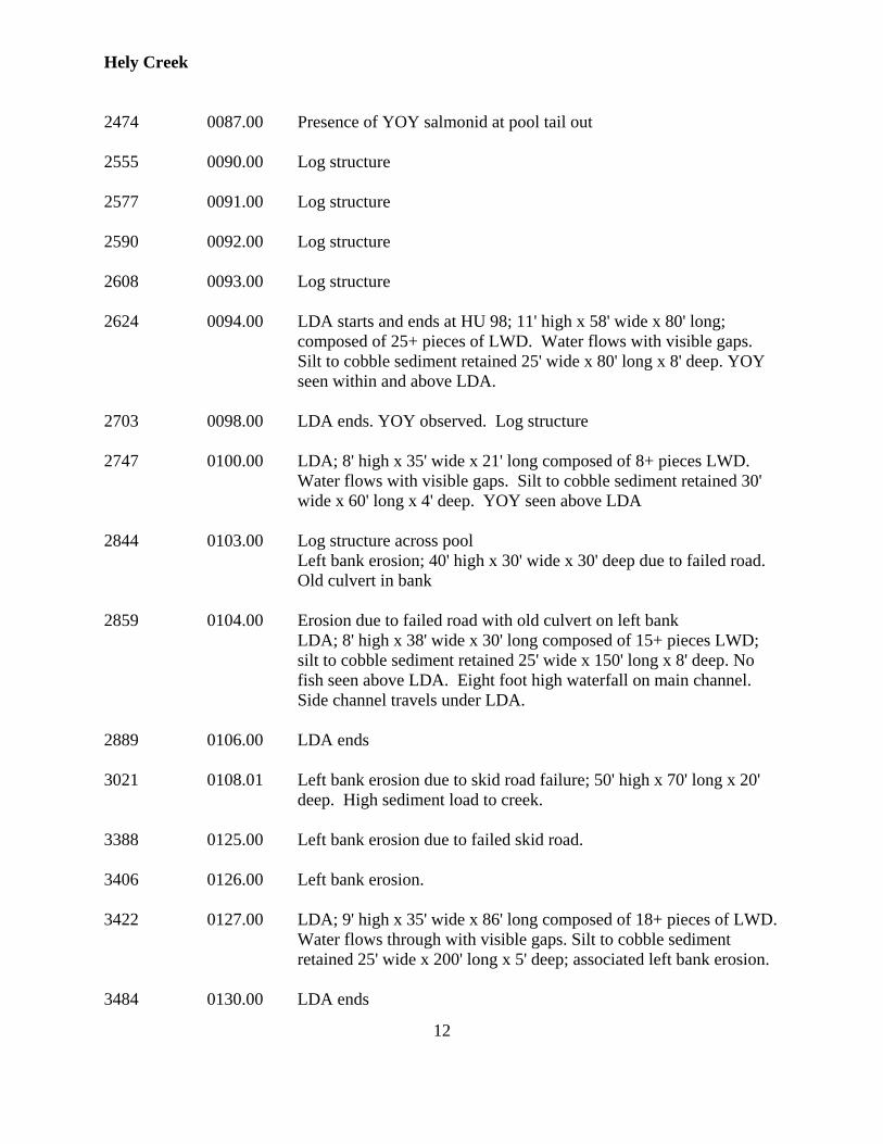
2474 0087.00 Presence of YOY salmonid at pool tail out 2555 0090.00 Log structure 2577 0091.00 Log structure 2590 0092.00 Log structure 2608 0093.00 Log structure 2624 0094.00 LDA starts and ends at HU 98; 11' high x 58' wide x 80' long;
composed of 25+ pieces of LWD. Water flows with visible gaps. Silt to cobble sediment retained 25' wide x 80' long x 8' deep. YOY seen within and above LDA.
2703 0098.00 LDA ends. YOY observed. Log structure 2747 0100.00 LDA; 8' high x 35' wide x 21' long composed of 8+ pieces LWD.
Water flows with visible gaps. Silt to cobble sediment retained 30' wide x 60' long x 4' deep. YOY seen above LDA
2844 0103.00 Log structure across pool Left bank erosion; 40' high x 30' wide x 30' deep due to failed road.
Old culvert in bank 2859 0104.00 Erosion due to failed road with old culvert on left bank LDA; 8' high x 38' wide x 30' long composed of 15+ pieces LWD;
silt to cobble sediment retained 25' wide x 150' long x 8' deep. No fish seen above LDA. Eight foot high waterfall on main channel. Side channel travels under LDA.
2889 0106.00 LDA ends 3021 0108.01 Left bank erosion due to skid road failure; 50' high x 70' long x 20'
deep. High sediment load to creek. 3388 0125.00 Left bank erosion due to failed skid road. 3406 0126.00 Left bank erosion. 3422 0127.00 LDA; 9' high x 35' wide x 86' long composed of 18+ pieces of LWD.
Water flows through with visible gaps. Silt to cobble sediment retained 25' wide x 200' long x 5' deep; associated left bank erosion.
3484 0130.00 LDA ends
Hely Creek
13
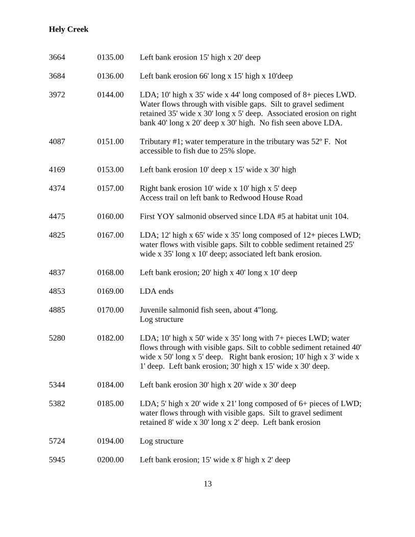
3664 0135.00 Left bank erosion 15' high x 20' deep 3684 0136.00 Left bank erosion 66' long x 15' high x 10'deep 3972 0144.00 LDA; 10' high x 35' wide x 44' long composed of 8+ pieces LWD.
Water flows through with visible gaps. Silt to gravel sediment retained 35' wide x 30' long x 5' deep. Associated erosion on right bank 40' long x 20' deep x 30' high. No fish seen above LDA.
4087 0151.00 Tributary #1; water temperature in the tributary was 52º F. Not
accessible to fish due to 25% slope. 4169 0153.00 Left bank erosion 10' deep x 15' wide x 30' high 4374 0157.00 Right bank erosion 10' wide x 10' high x 5' deep Access trail on left bank to Redwood House Road 4475 0160.00 First YOY salmonid observed since LDA #5 at habitat unit 104. 4825 0167.00 LDA; 12' high x 65' wide x 35' long composed of 12+ pieces LWD;
water flows with visible gaps. Silt to cobble sediment retained 25' wide x 35' long x 10' deep; associated left bank erosion.
4837 0168.00 Left bank erosion; 20' high x 40' long x 10' deep 4853 0169.00 LDA ends 4885 0170.00 Juvenile salmonid fish seen, about 4"long. Log structure 5280 0182.00 LDA; 10' high x 50' wide x 35' long with 7+ pieces LWD; water
flows through with visible gaps. Silt to cobble sediment retained 40' wide x 50' long x 5' deep. Right bank erosion; 10' high x 3' wide x 1' deep. Left bank erosion; 30' high x 15' wide x 30' deep.
5344 0184.00 Left bank erosion 30' high x 20' wide x 30' deep 5382 0185.00 LDA; 5' high x 20' wide x 21' long composed of 6+ pieces of LWD;
water flows through with visible gaps. Silt to gravel sediment retained 8' wide x 30' long x 2' deep. Left bank erosion
5724 0194.00 Log structure 5945 0200.00 Left bank erosion; 15' wide x 8' high x 2' deep
Hely Creek
14
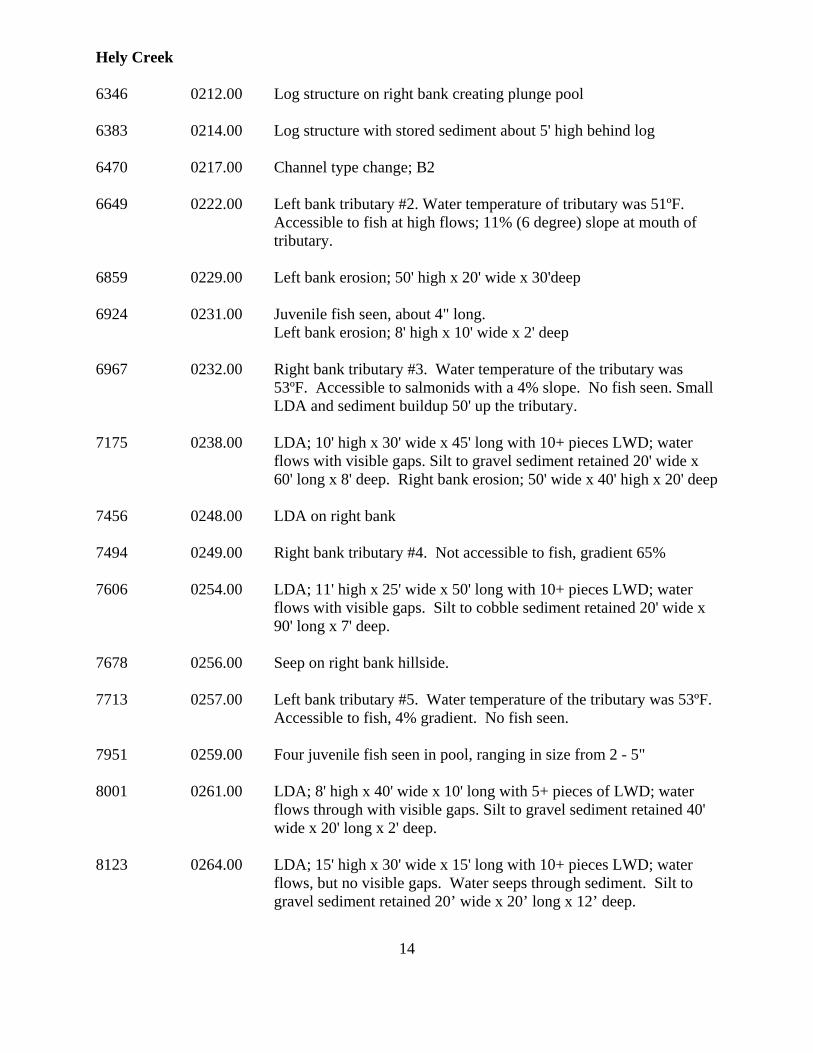
6346 0212.00 Log structure on right bank creating plunge pool 6383 0214.00 Log structure with stored sediment about 5' high behind log 6470 0217.00 Channel type change; B2 6649 0222.00 Left bank tributary #2. Water temperature of tributary was 51ºF.
Accessible to fish at high flows; 11% (6 degree) slope at mouth of tributary.
6859 0229.00 Left bank erosion; 50' high x 20' wide x 30'deep 6924 0231.00 Juvenile fish seen, about 4" long. Left bank erosion; 8' high x 10' wide x 2' deep 6967 0232.00 Right bank tributary #3. Water temperature of the tributary was
53ºF. Accessible to salmonids with a 4% slope. No fish seen. Small LDA and sediment buildup 50' up the tributary.
7175 0238.00 LDA; 10' high x 30' wide x 45' long with 10+ pieces LWD; water
flows with visible gaps. Silt to gravel sediment retained 20' wide x 60' long x 8' deep. Right bank erosion; 50' wide x 40' high x 20' deep
7456 0248.00 LDA on right bank 7494 0249.00 Right bank tributary #4. Not accessible to fish, gradient 65% 7606 0254.00 LDA; 11' high x 25' wide x 50' long with 10+ pieces LWD; water
flows with visible gaps. Silt to cobble sediment retained 20' wide x 90' long x 7' deep.
7678 0256.00 Seep on right bank hillside. 7713 0257.00 Left bank tributary #5. Water temperature of the tributary was 53ºF.
Accessible to fish, 4% gradient. No fish seen. 7951 0259.00 Four juvenile fish seen in pool, ranging in size from 2 - 5" 8001 0261.00 LDA; 8' high x 40' wide x 10' long with 5+ pieces of LWD; water
flows through with visible gaps. Silt to gravel sediment retained 40' wide x 20' long x 2' deep.
8123 0264.00 LDA; 15' high x 30' wide x 15' long with 10+ pieces LWD; water
flows, but no visible gaps. Water seeps through sediment. Silt to gravel sediment retained 20’ wide x 20’ long x 12’ deep.
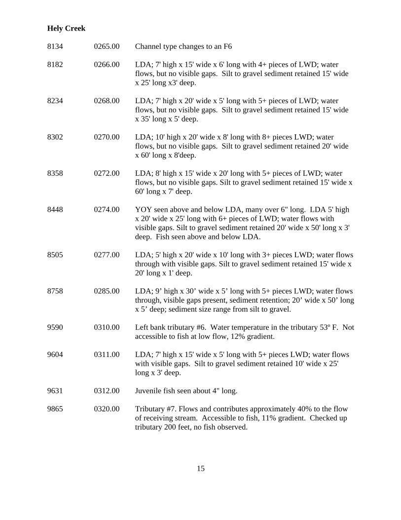
Hely Creek
15
8134 0265.00 Channel type changes to an F6 8182 0266.00 LDA; 7' high x 15' wide x 6' long with 4+ pieces of LWD; water
flows, but no visible gaps. Silt to gravel sediment retained 15' wide x 25' long x3' deep.
8234 0268.00 LDA; 7' high x 20' wide x 5' long with 5+ pieces of LWD; water
flows, but no visible gaps. Silt to gravel sediment retained 15' wide x 35' long x 5' deep.
8302 0270.00 LDA; 10' high x 20' wide x 8' long with 8+ pieces LWD; water
flows, but no visible gaps. Silt to gravel sediment retained 20' wide x 60' long x 8'deep.
8358 0272.00 LDA; 8' high x 15' wide x 20' long with 5+ pieces of LWD; water
flows, but no visible gaps. Silt to gravel sediment retained 15' wide x 60' long x 7' deep.
8448 0274.00 YOY seen above and below LDA, many over 6" long. LDA 5' high
x 20' wide x 25' long with 6+ pieces of LWD; water flows with visible gaps. Silt to gravel sediment retained 20' wide x 50' long x 3' deep. Fish seen above and below LDA.
8505 0277.00 LDA; 5' high x 20' wide x 10' long with 3+ pieces LWD; water flows
through with visible gaps. Silt to gravel sediment retained 15' wide x 20' long x 1' deep.
8758 0285.00 LDA; 9’ high x 30’ wide x 5’ long with 5+ pieces LWD; water flows
through, visible gaps present, sediment retention; 20’ wide x 50’ long x 5’ deep; sediment size range from silt to gravel.
9590 0310.00 Left bank tributary #6. Water temperature in the tributary 53º F. Not
accessible to fish at low flow, 12% gradient. 9604 0311.00 LDA; 7' high x 15' wide x 5' long with 5+ pieces LWD; water flows
with visible gaps. Silt to gravel sediment retained 10' wide x 25' long x 3' deep.
9631 0312.00 Juvenile fish seen about 4" long. 9865 0320.00 Tributary #7. Flows and contributes approximately 40% to the flow
of receiving stream. Accessible to fish, 11% gradient. Checked up tributary 200 feet, no fish observed.
Hely Creek
16
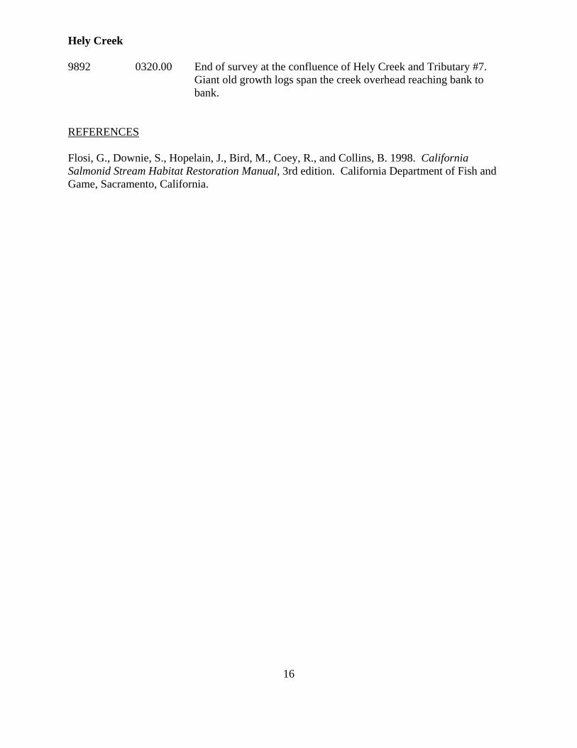
9892 0320.00 End of survey at the confluence of Hely Creek and Tributary #7. Giant old growth logs span the creek overhead reaching bank to bank.
REFERENCES Flosi, G., Downie, S., Hopelain, J., Bird, M., Coey, R., and Collins, B. 1998. California Salmonid Stream Habitat Restoration Manual, 3rd edition. California Department of Fish and Game, Sacramento, California.
Hely Creek
17
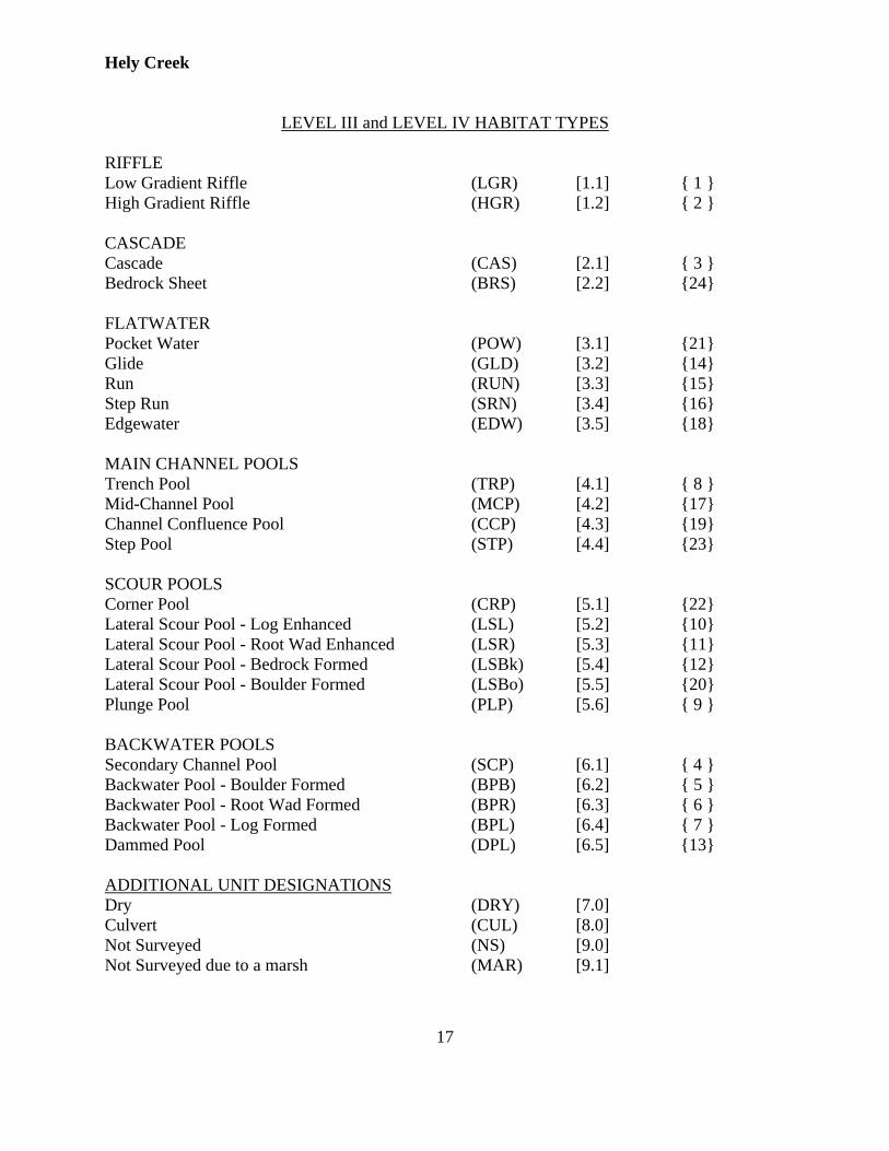
LEVEL III and LEVEL IV HABITAT TYPES RIFFLE Low Gradient Riffle (LGR) [1.1] { 1 } High Gradient Riffle (HGR) [1.2] { 2 } CASCADE Cascade (CAS) [2.1] { 3 } Bedrock Sheet (BRS) [2.2] {24} FLATWATER Pocket Water (POW) [3.1] {21} Glide (GLD) [3.2] {14} Run (RUN) [3.3] {15} Step Run (SRN) [3.4] {16} Edgewater (EDW) [3.5] {18} MAIN CHANNEL POOLS Trench Pool (TRP) [4.1] { 8 } Mid-Channel Pool (MCP) [4.2] {17} Channel Confluence Pool (CCP) [4.3] {19} Step Pool (STP) [4.4] {23} SCOUR POOLS Corner Pool (CRP) [5.1] {22} Lateral Scour Pool - Log Enhanced (LSL) [5.2] {10} Lateral Scour Pool - Root Wad Enhanced (LSR) [5.3] {11} Lateral Scour Pool - Bedrock Formed (LSBk) [5.4] {12} Lateral Scour Pool - Boulder Formed (LSBo) [5.5] {20} Plunge Pool (PLP) [5.6] { 9 } BACKWATER POOLS Secondary Channel Pool (SCP) [6.1] { 4 } Backwater Pool - Boulder Formed (BPB) [6.2] { 5 } Backwater Pool - Root Wad Formed (BPR) [6.3] { 6 } Backwater Pool - Log Formed (BPL) [6.4] { 7 } Dammed Pool (DPL) [6.5] {13} ADDITIONAL UNIT DESIGNATIONS Dry (DRY) [7.0] Culvert (CUL) [8.0] Not Surveyed (NS) [9.0] Not Surveyed due to a marsh (MAR) [9.1]
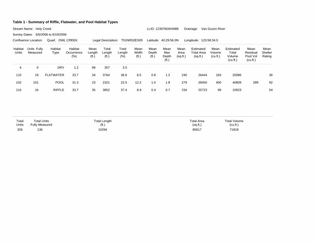
Table 1 - Summary of Riffle, Flatwater, and Pool Habitat Types
Stream Name:
Survey Dates:
Confluence Location: Quad: Legal Description: Latitude: Longitude:
Drainage:Hely Creek Van Duzen River
6/5/2006 to 6/19/2006
OWL CREEK T01NR02ES05 40:29:56.0N 123:58:34.0
HabitatUnits
Units FullyMeasured
HabitatType
HabitatOccurrence
(%)
MeanLength
(ft.)
TotalLength
(ft.)
TotalLength
(%)
MeanWidth(ft.)
MeanDepth
(ft.)
MeanArea
(sq.ft.)
EstimatedTotal Area
(sq.ft.)
MeanVolume(cu.ft.)
EstimatedTotal
Volume(cu.ft.)
MeanResidualPool Vol(cu.ft.)
MeanShelterRating
MeanMax
Depth(ft.)
LLID: 1239760404988
DRY0 1.2 89 357 3.54
FLATWATER19 33.7 34 3764 36.6 8.5 0.8 240 26444 183 20086 36110 1.2
POOL101 31.3 23 2321 22.5 12.2 1.0 279 28450 400 40809 289 92102 1.8
RIFFLE16 33.7 35 3852 37.4 8.9 0.4 234 25723 99 10923 54110 0.7
Total UnitsFully Measured
Total Length(ft.)
Total Area(sq.ft.)
Total Volume(cu.ft.)
TotalUnits326 136 10294 80617 71818
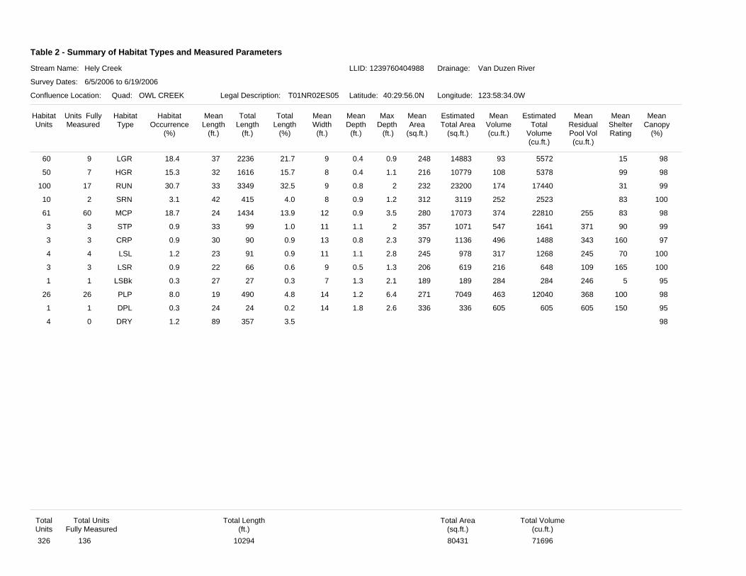
Table 2 - Summary of Habitat Types and Measured Parameters
Stream Name:
Survey Dates:
Confluence Location: Quad: Legal Description: Latitude: Longitude:
Drainage:Hely Creek Van Duzen River
6/5/2006 to 6/19/2006
OWL CREEK T01NR02ES05 40:29:56.0N 123:58:34.0W
HabitatUnits
Units FullyMeasured
HabitatType
HabitatOccurrence
(%)
MeanLength
(ft.)
TotalLength
(ft.)
TotalLength
(%)
MeanWidth(ft.)
MeanDepth
(ft.)
MeanArea
(sq.ft.)
EstimatedTotal Area
(sq.ft.)
MeanVolume(cu.ft.)
EstimatedTotal
Volume(cu.ft.)
MeanResidualPool Vol(cu.ft.)
MeanShelterRating
MeanCanopy
(%)
MaxDepth (ft.)
LLID: 1239760404988
LGR9 18.4 37 2236 21.7 9 0.4 248 14883 93 5572 1560 980.9
HGR7 15.3 32 1616 15.7 8 0.4 216 10779 108 5378 9950 981.1
RUN17 30.7 33 3349 32.5 9 0.8 232 23200 174 17440 31100 992
SRN2 3.1 42 415 4.0 8 0.9 312 3119 252 2523 8310 1001.2
MCP60 18.7 24 1434 13.9 12 0.9 280 17073 374 22810 255 8361 983.5
STP3 0.9 33 99 1.0 11 1.1 357 1071 547 1641 371 903 992
CRP3 0.9 30 90 0.9 13 0.8 379 1136 496 1488 343 1603 972.3
LSL4 1.2 23 91 0.9 11 1.1 245 978 317 1268 245 704 1002.8
LSR3 0.9 22 66 0.6 9 0.5 206 619 216 648 109 1653 1001.3
LSBk1 0.3 27 27 0.3 7 1.3 189 189 284 284 246 51 952.1
PLP26 8.0 19 490 4.8 14 1.2 271 7049 463 12040 368 10026 986.4
DPL1 0.3 24 24 0.2 14 1.8 336 336 605 605 605 1501 952.6
DRY0 1.2 89 357 3.54 98
Total UnitsFully Measured
Total Length(ft.)
Total Area(sq.ft.)
Total Volume(cu.ft.)
TotalUnits326 136 10294 80431 71696
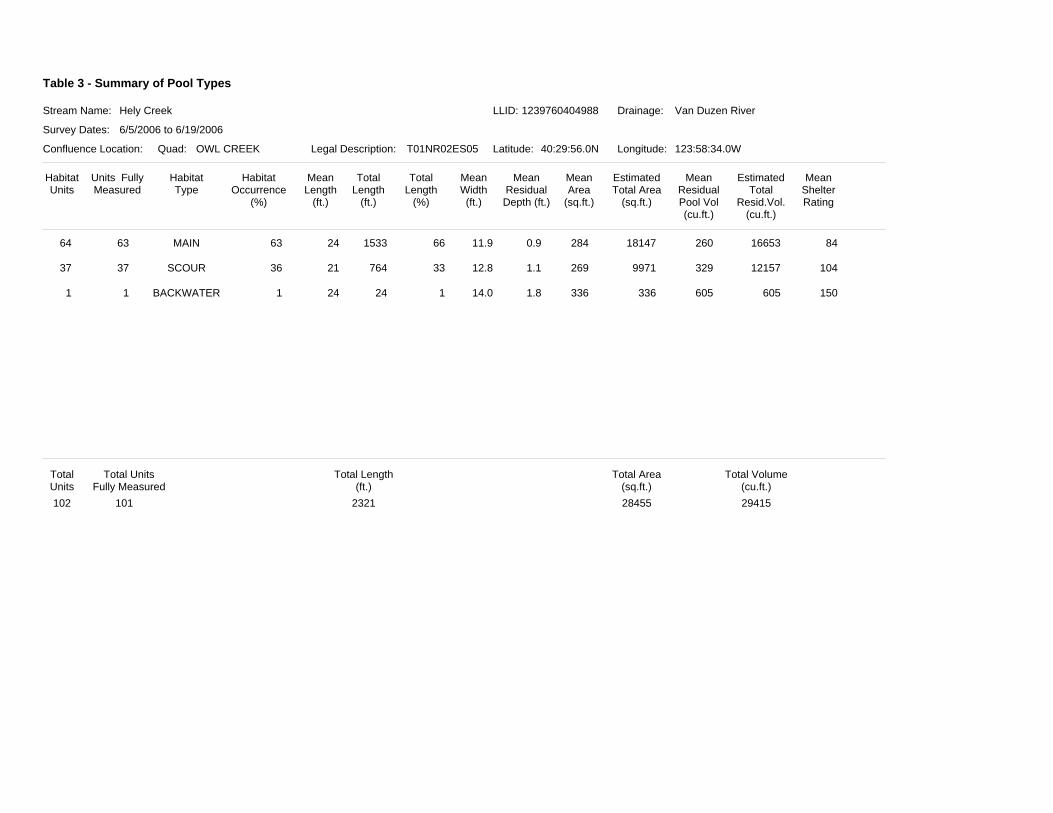
Table 3 - Summary of Pool Types
Stream Name:
Survey Dates:
Confluence Location: Quad: Legal Description: Latitude: Longitude:
Drainage:Hely Creek Van Duzen River
6/5/2006 to 6/19/2006
OWL CREEK T01NR02ES05 40:29:56.0N 123:58:34.0W
HabitatUnits
Units FullyMeasured
HabitatType
HabitatOccurrence
(%)
MeanLength
(ft.)
TotalLength
(ft.)
TotalLength
(%)
MeanWidth(ft.)
MeanResidualDepth (ft.)
MeanArea
(sq.ft.)
EstimatedTotal Area
(sq.ft.)
EstimatedTotal
Resid.Vol.(cu.ft.)
MeanResidualPool Vol(cu.ft.)
MeanShelterRating
LLID: 1239760404988
MAIN63 63 24 1533 66 11.9 0.9 284 18147 16653260 8464
SCOUR37 36 21 764 33 12.8 1.1 269 9971 12157329 10437
BACKWATER1 1 24 24 1 14.0 1.8 336 336 605605 1501
Total UnitsFully Measured
Total Length(ft.)
Total Area(sq.ft.)
Total Volume(cu.ft.)
TotalUnits102 101 2321 28455 29415
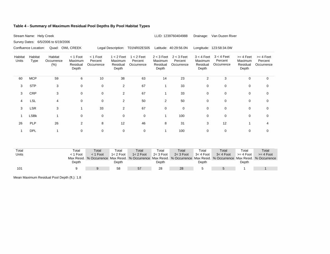
Table 4 - Summary of Maximum Residual Pool Depths By Pool Habitat Types
Stream Name:
Survey Dates:
Confluence Location: Quad: Legal Description: Latitude: Longitude:
Drainage:Hely Creek Van Duzen River
6/5/2006 to 6/19/2006
OWL CREEK T01NR02ES05 40:29:56.0N 123:58:34.0W
HabitatUnits
HabitatType
HabitatOccurrence
(%)
< 1 FootMaximumResidual
Depth
< 1 FootPercent
Occurrence
1 < 2 FeetMaximumResidual
Depth
1 < 2 FeetPercent
Occurrence
2 < 3 FeetMaximumResidual
Depth
2 < 3 FeetPercent
Occurrence
3 < 4 FeetMaximumResidual
Depth
3 < 4 FeetPercent
Occurrence
>= 4 FeetMaximumResidual
Depth
>= 4 FeetPercent
Occurrence
LLID: 1239760404988
MCP 5960 6 10 38 63 14 23 2 3 0 0
STP 33 0 0 2 67 1 33 0 0 0 0
CRP 33 0 0 2 67 1 33 0 0 0 0
LSL 44 0 0 2 50 2 50 0 0 0 0
LSR 33 1 33 2 67 0 0 0 0 0 0
LSBk 11 0 0 0 0 1 100 0 0 0 0
PLP 2626 2 8 12 46 8 31 3 12 1 4
DPL 11 0 0 0 0 1 100 0 0 0 0
TotalUnits
101
Total< 1 Foot
Max Resid.Depth
Total< 1 Foot
% Occurrence
Total1< 2 Foot
Max Resid.Depth
Total1< 2 Foot
% Occurrence
Total2< 3 Foot
Max Resid.Depth
Total2< 3 Foot
% Occurrence
Total3< 4 Foot
Max Resid.Depth
Total3< 4 Foot
% Occurrence
Total>= 4 Foot
Max Resid.Depth
Total>= 4 Foot
% Occurrence
9 9 58 57 28 28 5 5 1 1
Mean Maximum Residual Pool Depth (ft.): 1.8
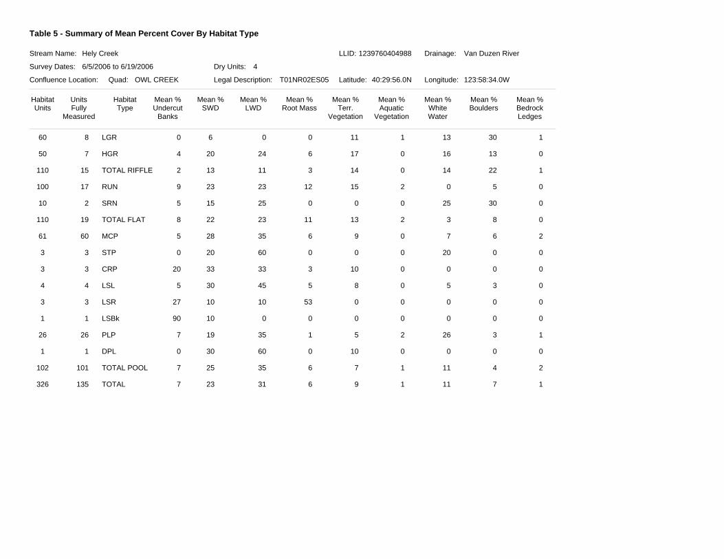
Table 5 - Summary of Mean Percent Cover By Habitat Type
Stream Name:
Survey Dates:
Confluence Location: Quad: Legal Description: Latitude: Longitude:
Drainage:Hely Creek Van Duzen River
6/5/2006 to 6/19/2006
OWL CREEK T01NR02ES05 40:29:56.0N 123:58:34.0W
HabitatUnits
HabitatType
Mean %Undercut
Banks
Mean %SWD
Mean %LWD
Mean %Root Mass
Mean %Terr.
Vegetation
Mean %Aquatic
Vegetation
Mean %WhiteWater
Mean %Boulders
Mean %BedrockLedges
UnitsFully
Measured
Dry Units: 4
LLID: 1239760404988
LGR860 6 0 11 1 1300 30 1
HGR750 20 6 17 0 16244 13 0
TOTAL RIFFLE15110 13 3 14 0 14112 22 1
RUN17100 23 12 15 2 0239 5 0
SRN210 15 0 0 0 25255 30 0
TOTAL FLAT19110 22 11 13 2 3238 8 0
MCP6061 28 6 9 0 7355 6 2
STP33 20 0 0 0 20600 0 0
CRP33 33 3 10 0 03320 0 0
LSL44 30 5 8 0 5455 3 0
LSR33 10 53 0 0 01027 0 0
LSBk11 10 0 0 0 0090 0 0
PLP2626 19 1 5 2 26357 3 1
DPL11 30 0 10 0 0600 0 0
TOTAL POOL101102 25 6 7 1 11357 4 2
TOTAL135326 23 6 9 1 11317 7 1
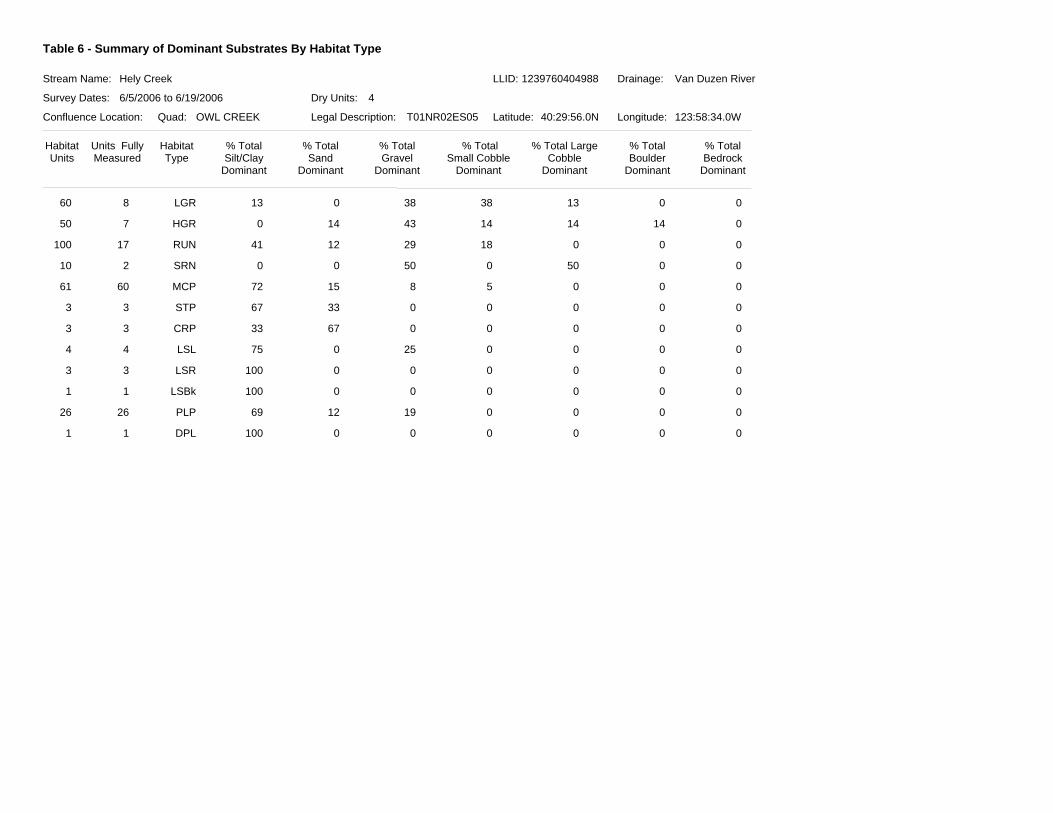
Table 6 - Summary of Dominant Substrates By Habitat Type
Stream Name:
Survey Dates:
Confluence Location: Quad: Legal Description: Latitude: Longitude:
Drainage:Hely Creek Van Duzen River
6/5/2006 to 6/19/2006
OWL CREEK T01NR02ES05 40:29:56.0N 123:58:34.0W
HabitatUnits
HabitatType
% TotalSilt/Clay
Dominant
% TotalSand
Dominant
% TotalGravel
Dominant
% TotalSmall Cobble
Dominant
% Total LargeCobble
Dominant
% TotalBoulder
Dominant
% TotalBedrock
Dominant
Units FullyMeasured
Dry Units: 4
LLID: 1239760404988
LGR860 0 38 13 0 03813
HGR750 14 14 14 14 0430
RUN17100 12 18 0 0 02941
SRN210 0 0 50 0 0500
MCP6061 15 5 0 0 0872
STP33 33 0 0 0 0067
CRP33 67 0 0 0 0033
LSL44 0 0 0 0 02575
LSR33 0 0 0 0 00100
LSBk11 0 0 0 0 00100
PLP2626 12 0 0 0 01969
DPL11 0 0 0 0 00100
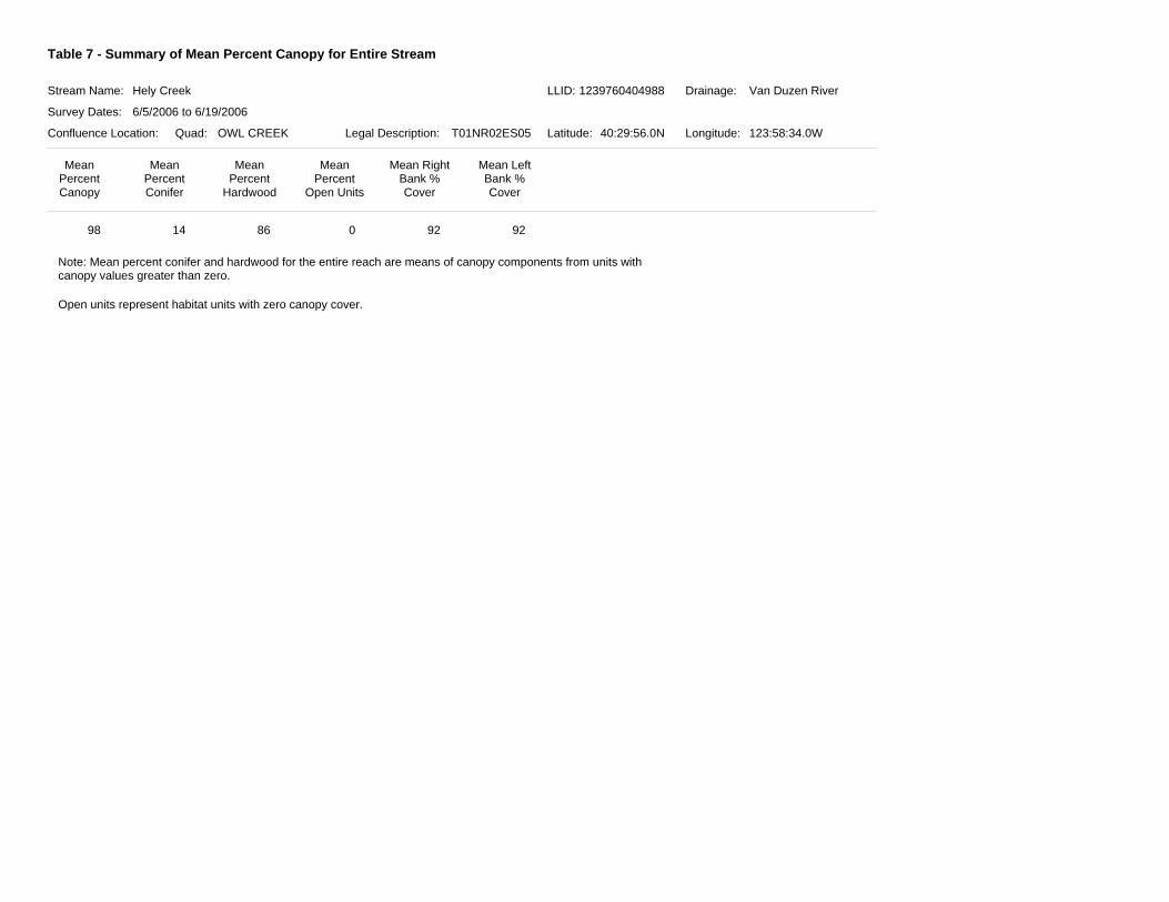
Table 7 - Summary of Mean Percent Canopy for Entire Stream
Stream Name:
Survey Dates:
Confluence Location: Quad: Legal Description: Latitude: Longitude:
Drainage:Hely Creek Van Duzen River
6/5/2006 to 6/19/2006
OWL CREEK T01NR02ES05 40:29:56.0N 123:58:34.0W
MeanPercentCanopy
MeanPercent
Hardwood
MeanPercent
Open Units
MeanPercentConifer
Mean RightBank %Cover
Mean LeftBank %Cover
LLID: 1239760404988
14 08698
Note: Mean percent conifer and hardwood for the entire reach are means of canopy components from units withcanopy values greater than zero.
Open units represent habitat units with zero canopy cover.
92 92
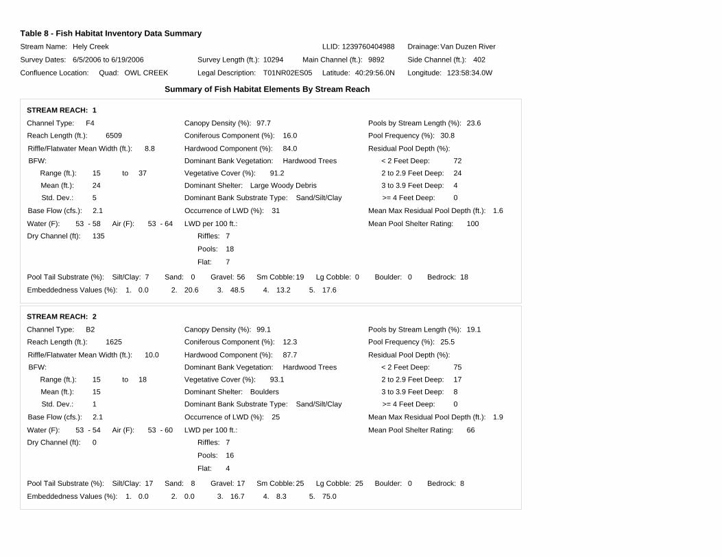
Table 8 - Fish Habitat Inventory Data SummaryStream Name:
Survey Dates:
Confluence Location: Quad: Legal Description: Latitude: Longitude:
Drainage:Hely Creek Van Duzen River
6/5/2006 to 6/19/2006
OWL CREEK T01NR02ES05 40:29:56.0N 123:58:34.0W
Survey Length (ft.): Main Channel (ft.): Side Channel (ft.):10294 9892 402
LLID: 1239760404988
Summary of Fish Habitat Elements By Stream Reach
STREAM REACH: 1
Channel Type:
Reach Length (ft.):
F4
6509
Riffle/Flatwater Mean Width (ft.):
Base Flow (cfs.):
8.8
2.1
Water (F): Air (F):
Dominant Bank Vegetation:
Vegetative Cover (%):
Dominant Bank Substrate Type:
53
Hardwood Trees
91.2
Sand/Silt/Clay
- 58 6453 -
Canopy Density (%):
Coniferous Component (%):
Hardwood Component (%):
Pools by Stream Length (%):
2 to 2.9 Feet Deep:
Mean Pool Shelter Rating:
Dominant Shelter:
Occurrence of LWD (%):
Dry Channel (ft):
97.7
16.0
84.0
23.6
100
Large Woody Debris
31
135
Embeddedness Values (%): 1. 2. 3. 4. 5.0.0 20.6 17.648.5 13.2
Pool Frequency (%):
Residual Pool Depth (%):
BFW: < 2 Feet Deep:
>= 4 Feet Deep:
3 to 3.9 Feet Deep:
Mean Max Residual Pool Depth (ft.):
LWD per 100 ft.:
Riffles:
Pools:
Flat:
Range (ft.):
Mean (ft.):
Std. Dev.:
to
Pool Tail Substrate (%): Silt/Clay: Sand: Gravel: Sm Cobble: Lg Cobble: Boulder: Bedrock:
15 37
24
5
30.8
1.6
72
24
4
0
7 560 19 00 18
7
18
7
STREAM REACH: 2
Channel Type:
Reach Length (ft.):
B2
1625
Riffle/Flatwater Mean Width (ft.):
Base Flow (cfs.):
10.0
2.1
Water (F): Air (F):
Dominant Bank Vegetation:
Vegetative Cover (%):
Dominant Bank Substrate Type:
53
Hardwood Trees
93.1
Sand/Silt/Clay
- 54 6053 -
Canopy Density (%):
Coniferous Component (%):
Hardwood Component (%):
Pools by Stream Length (%):
2 to 2.9 Feet Deep:
Mean Pool Shelter Rating:
Dominant Shelter:
Occurrence of LWD (%):
Dry Channel (ft):
99.1
12.3
87.7
19.1
66
Boulders
25
0
Embeddedness Values (%): 1. 2. 3. 4. 5.0.0 0.0 75.016.7 8.3
Pool Frequency (%):
Residual Pool Depth (%):
BFW: < 2 Feet Deep:
>= 4 Feet Deep:
3 to 3.9 Feet Deep:
Mean Max Residual Pool Depth (ft.):
LWD per 100 ft.:
Riffles:
Pools:
Flat:
Range (ft.):
Mean (ft.):
Std. Dev.:
to
Pool Tail Substrate (%): Silt/Clay: Sand: Gravel: Sm Cobble: Lg Cobble: Boulder: Bedrock:
15 18
15
1
25.5
1.9
75
17
8
0
17 178 25 025 8
7
16
4
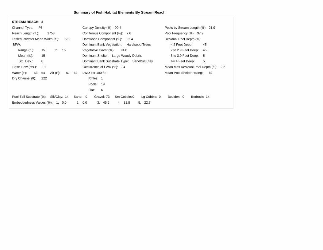
Summary of Fish Habitat Elements By Stream Reach
STREAM REACH: 3
Channel Type:
Reach Length (ft.):
F6
1758
Riffle/Flatwater Mean Width (ft.):
Base Flow (cfs.):
6.5
2.1
Water (F): Air (F):
Dominant Bank Vegetation:
Vegetative Cover (%):
Dominant Bank Substrate Type:
53
Hardwood Trees
94.0
Sand/Silt/Clay
- 54 6257 -
Canopy Density (%):
Coniferous Component (%):
Hardwood Component (%):
Pools by Stream Length (%):
2 to 2.9 Feet Deep:
Mean Pool Shelter Rating:
Dominant Shelter:
Occurrence of LWD (%):
Dry Channel (ft):
99.4
7.6
92.4
21.9
82
Large Woody Debris
34
222
Embeddedness Values (%): 1. 2. 3. 4. 5.0.0 0.0 22.745.5 31.8
Pool Frequency (%):
Residual Pool Depth (%):
BFW: < 2 Feet Deep:
>= 4 Feet Deep:
3 to 3.9 Feet Deep:
Mean Max Residual Pool Depth (ft.):
LWD per 100 ft.:
Riffles:
Pools:
Flat:
Range (ft.):
Mean (ft.):
Std. Dev.:
to
Pool Tail Substrate (%): Silt/Clay: Sand: Gravel: Sm Cobble: Lg Cobble: Boulder: Bedrock:
15 15
15
0
37.9
2.2
45
45
5
5
14 730 0 00 14
1
19
6
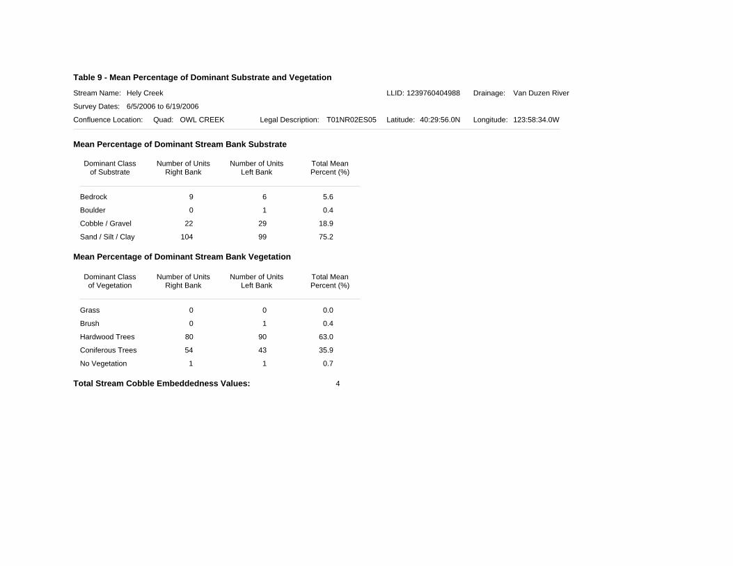
Table 9 - Mean Percentage of Dominant Substrate and Vegetation
Stream Name:
Survey Dates:
Confluence Location: Quad: Legal Description: Latitude: Longitude:
Drainage:Hely Creek Van Duzen River
6/5/2006 to 6/19/2006
OWL CREEK T01NR02ES05 40:29:56.0N 123:58:34.0W
LLID: 1239760404988
Mean Percentage of Dominant Stream Bank Substrate
Mean Percentage of Dominant Stream Bank Vegetation
Total Stream Cobble Embeddedness Values:
Bedrock
Boulder
Cobble / Gravel
Sand / Silt / Clay
Grass
Brush
Hardwood Trees
Coniferous Trees
No Vegetation
Dominant Classof Substrate
Number of UnitsRight Bank
Number of UnitsLeft Bank
Total MeanPercent (%)
Dominant Classof Vegetation
Number of UnitsRight Bank
Number of UnitsLeft Bank
Total MeanPercent (%)
9 6 5.6
0 1 0.4
22 29 18.9
104 99 75.2
0 0 0.0
0 1 0.4
80 90 63.0
54 43 35.9
1 1 0.7
4
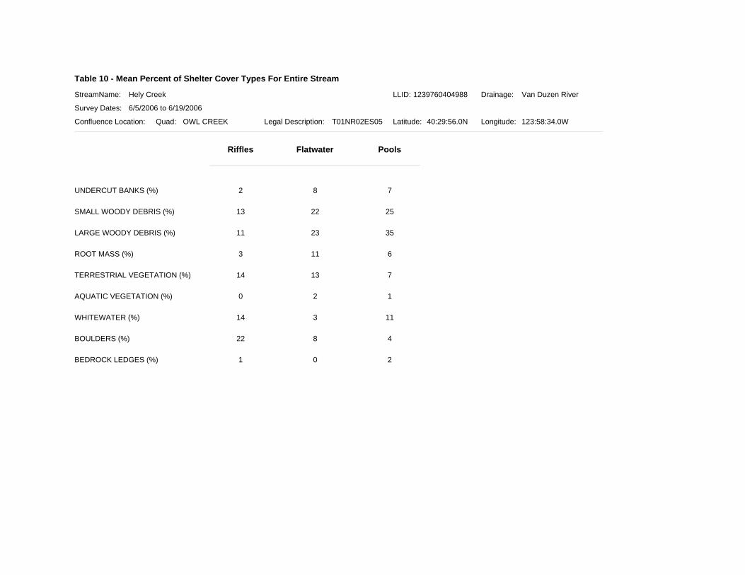
Table 10 - Mean Percent of Shelter Cover Types For Entire Stream
StreamName:
Survey Dates:
Confluence Location: Quad: Legal Description: Latitude: Longitude:
Drainage:Hely Creek Van Duzen River
6/5/2006 to 6/19/2006
OWL CREEK T01NR02ES05 40:29:56.0N 123:58:34.0W
Riffles Flatwater Pools
LLID: 1239760404988
UNDERCUT BANKS (%) 2 8 7
SMALL WOODY DEBRIS (%) 13 22 25
LARGE WOODY DEBRIS (%) 11 23 35
ROOT MASS (%) 3 11 6
TERRESTRIAL VEGETATION (%) 14 13 7
AQUATIC VEGETATION (%) 0 2 1
WHITEWATER (%) 14 3 11
BOULDERS (%) 22 8 4
BEDROCK LEDGES (%) 1 0 2
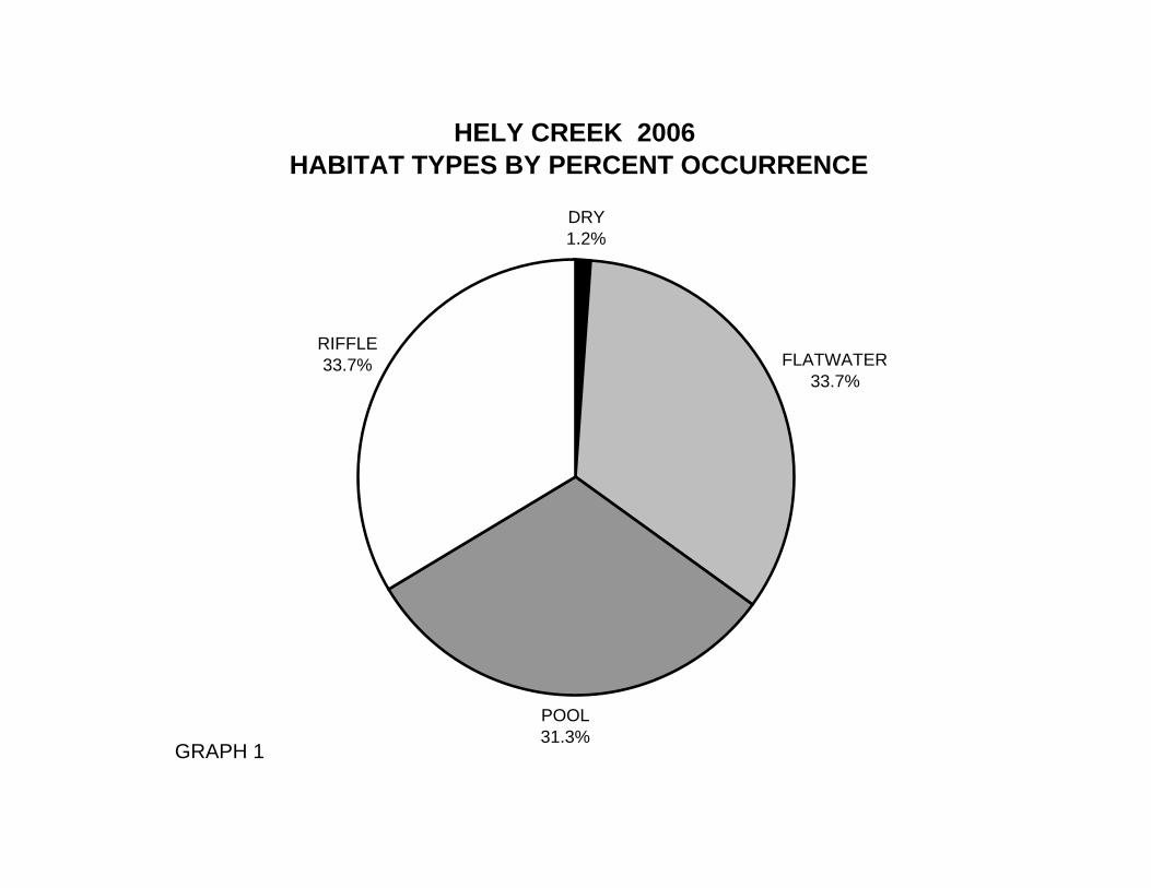
HELY CREEK 2006 HABITAT TYPES BY PERCENT OCCURRENCE
DRY1.2%
FLATWATER33.7%
POOL31.3%
RIFFLE33.7%
GRAPH 1
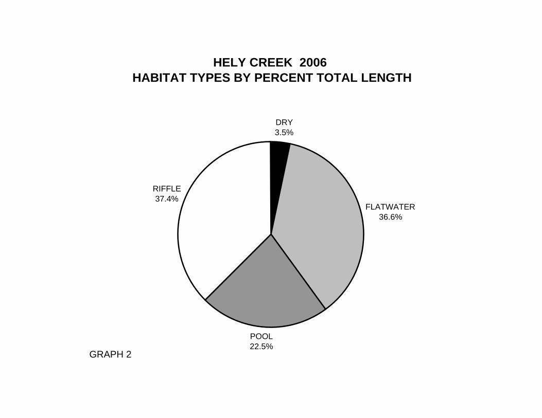
HELY CREEK 2006 HABITAT TYPES BY PERCENT TOTAL LENGTH
DRY3.5%
FLATWATER36.6%
POOL22.5%
RIFFLE37.4%
GRAPH 2
HELY CREEK 2006 HABITAT TYPES BY PERCENT OCCURRENCE
0%
5%
10%
15%
20%
25%
30%
35%
LGR HGR RUN SRN MCP STP CRP LSL LSR LSBk PLP DPL DRY
HABITAT TYPE
PER
CEN
T O
CC
UR
REN
CE
GRAPH 3
HELY CREEK 2006 POOL TYPES BY PERCENT OCCURRENCE
BACKWATER1.0%
MAIN62.7%
SCOUR36.3%
GRAPH 4
HELY CREEK 2006 MAXIMUM DEPTH IN POOLS
0
10
20
30
40
50
60
70
<1 FOOT 1-<2 FEET 2-<3 FEET 3-<4 FEET >=4 FEET
MAXIMUM RESIDUAL DEPTH
# O
F PO
OLS
GRAPH 5
HELY CREEK 2006 PERCENT EMBEDDEDNESS
VALUE 213.7%
VALUE 344.1%
VALUE 416.7%
VALUE 525.5%
GRAPH 6
HELY CREEK 2006 MEAN PERCENT COVER TYPES IN POOLS
UNDERCUT BANKS7.5%
BEDROCK LEDGES1.6%
BOULDERS4.5%
WHITEWATER11.5%
AQUATIC VEG0.6%
TERRESTRIAL VEG7.2%
ROOT MASS5.7%
LARGE WOODY DEBRIS35.3%
SMALL WOODY DEBRIS25.1%
GRAPH 7
HELY CREEK 2006 SUBSTRATE COMPOSITION IN POOL TAIL-OUTS
0
10
20
30
40
50
60
SILT/CLAY SAND GRAVEL SMALL COBBLE LARGE COBBLE BOULDER BEDROCK
SUBSTRATE
% O
F PO
OL
TAIL
-OU
TS
GRAPH 8
HELY CREEK 2006 MEAN PERCENT CANOPY
CONIFEROUS TREES13.6%
HARDWOOD TREES84.6%
OPEN1.7%
GRAPH 9
HELY CREEK 2006 DOMINANT BANK COMPOSITION IN SURVEY REACH
SAND/SILT/CLAY75.2%
BOULDER0.4%
COBBLE/GRAVEL18.9%
BEDROCK5.6%
GRAPH 10
HELY CREEK 2006 DOMINANT BANK VEGETATION IN SURVEY REACH
HARDWOOD TREES63.0%
CONIFEROUS TREES35.9%
NO VEGETATION0.7%
BRUSH0.4%
GRAPH 11