Embed Size (px)
Citation preview

Stream Management Plan Workshop
Step 5 - Existing Data Collection
Data as a Platform
Colorado Water Congress Conference Workshop, August 23-24, 2016
Steve Malers, Open Water Foundation
www.openwaterfoundation.org
2open water
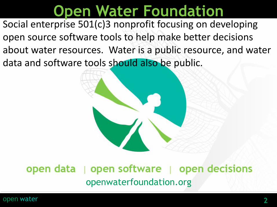
Open Water FoundationSocial enterprise 501(c)3 nonprofit focusing on developing open source software tools to help make better decisions about water resources. Water is a public resource, and water data and software tools should also be public.
openwaterfoundation.org

3open water
Stream Management Plan
“(5) collecting and synthesizing existing data
describing flows for river ecosystems,
boating, or other needs in the watershed”- Colorado Water Plan
Translation: How much wet water do you
need, where, and when for environment and
recreation?
Also: Water touches everything…and so does
data.

4open water
Some Initial Thoughts• Draw a picture of what you want
to do
It will guide what you need as
input, process, and output
Sooner or later you will need to
explain what you are doing with
a picture
• Good ideas come from
anywhere…you just need to find
them (or have someone show you)
• Create a culture of true
innovation… “the art of the
possible”
• Create and leverage building
blocks
“-The Connected Company”
designorate.com
Have you seen this elsewhere…cone of uncertainty?

5open water
Telling Your Story with Data
“There are two goals
when presenting data:
convey your story and
establish credibility.”
-Edward Tufte
https://en.wikipedia.org/wiki/Edward_Tufte

6open water
Your Data Challenge
• Main activities around data:
collect
manage
enhance/modify/quality control
use to analyze/model
visualize
attribute/document/archive/publish
• Do you need a data management plan in your
stream management plan?
Perhaps, but keep it simple via conventions
(who decides on the conventions?)

7open water
Diffusion of Innovation
http://www.datameer.com/blog/big-data-analytics-perspectives/big-data-crossing-the-chasm-in-2013.html
http://en.wikipedia.org/wiki/Crossing_the_Chasm
Crossing the Chasm (Geoffrey Moore)
Early AdoptersIdea!
Sell it
Prototype/Test it
Scale it
Use it / Support it
Evolve it / Start over
• Plan
• Do
• Check
• Act
Benefit from it

8open water
Time is REALLY Important
• Time series of data
Raw time series data
Time series of spatial data layers
Animations?
What scale/precision? real-time? daily/monthly/annual
historical?
• Timestamping/versioning datasets
Evolving datasets must be tracked
Timestamps need standards: YYYY-MM-DD, YYYYMMDD
• The meaning of time:
Observation date/time (when measured)
Effective date/time (when something goes into effect)
Publish date/time, including software versions
Things change so timestamp is important!

9open water
Location is REALLY Important
• Spatial coordinates (geographic or other coordinate system)
• Relationship (upstream, downstream, network)
• Stream mile (from state line, confluence)
• How important are accuracy and precision?
Things change!
Things change in time… and space!

10open water
Data schema is REALLY Important
• “schema” = organization or structure
• Consistent definitions
• “conceptual integrity” = things fit together
• Unique data identifiers
• ideally NOT internal database identifiers
• best to use original source identifiers used in business
processes if possible
• Relationships between datasets
• direct often better (example=stream ID)
• inferred or calculated may be more difficult to populate
and may not be as good (spatial intersect)
• Transportability (works with different computers, tools)
Does dataset have a time element?
Does dataset have a spatial element?
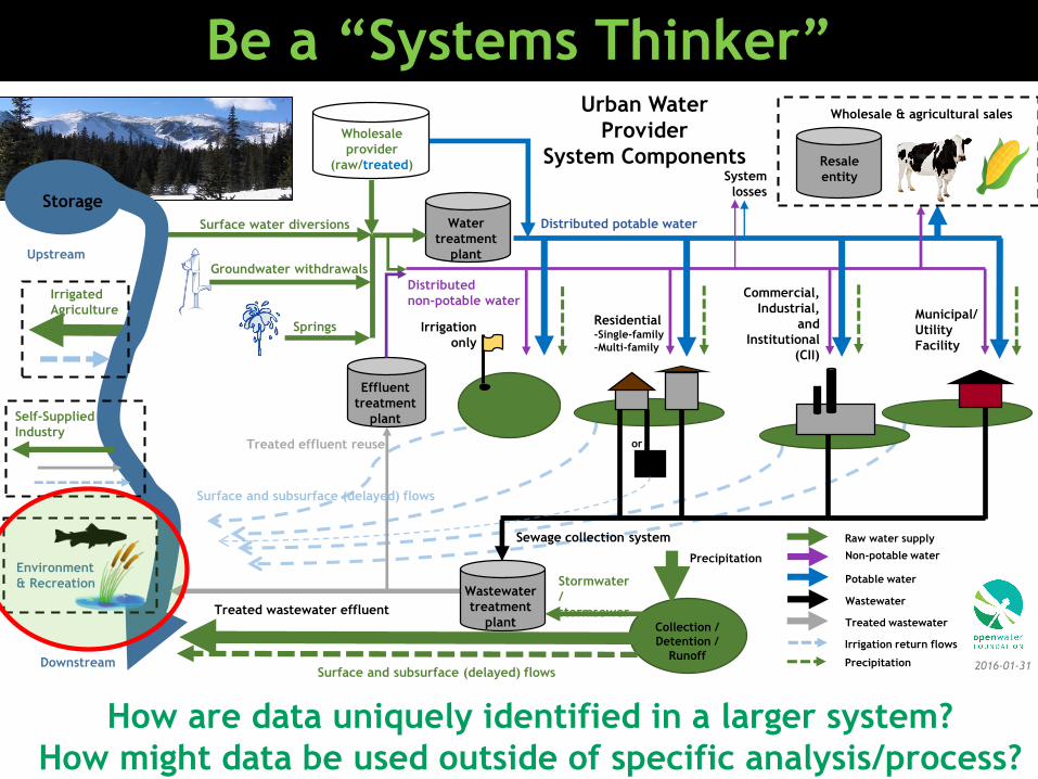
Be a “Systems Thinker”
Groundwater withdrawals
Wholesale
provider
(raw/treated)
Springs
Water
treatment
plant
Wastewater
treatment
plant
Non-potable water
Potable water
Wastewater
Treated wastewater
Distributed
non-potable water
Distributed potable water
Municipal/
Utility
Facility
Commercial,
Industrial,
and
Institutional
(CII)
Residential-Single-family
-Multi-family
Irrigation
only
Resale
entity
Wholesale & agricultural sales
Treated wastewater effluent
Raw water supply
2016-01-31
Urban Water
Provider
System Components
Downstream
Effluent
treatment
plant
System
losses
Treated effluent reuse
Sewage collection system
Surface water diversions
Stormwater
/
stormsewer
Irrigation return flows
Precipitation
Precipitation
or
Upstream
Surface and subsurface (delayed) flows
Surface and subsurface (delayed) flows
Irrigated
Agriculture
Collection /
Detention /
Runoff
Environment
& Recreation
Storage
Self-Supplied
Industry
How are data uniquely identified in a larger system?
How might data be used outside of specific analysis/process?

12open water
Open Data Definition
• Accessible to all – the data becomes accessible
outside of the organization that generated or
collected it
• Machine-readable – data must be usable, which
means it must be made available in formats that are
easily used by third-party applications
• Free – zero or low costs for data access and
openness
• Unrestricted rights to use – data that is
unencumbered by contractual or other restrictions
leads to the maximum potential of innovation- “Generating Economic Value through Open Data” in “Beyond Transparency”

13open water
1+1=2
The Role of Automation• Automation is fundamental to software/process testing and
validating tools.
• Automation requires documentation, simplifies sharing.
• Manual processes are error-prone.
• Manual processes do not scale.
• “Automation frees people to do their best work”.
…need to understand the opacity/transparency of automation

14open water
One-off vs Framework/Platform
One-off
Framework/
Platform
• Just do it!
• I don’t have time to
figure out a better way!
• Don’t expect to do task
again.
• Manual effort.
• Effort and cost?
• Who is responsible?
• Invest in tools and processes.
• They can and should be flexible
to a degree.
• Assume that a task will need to
be repeated later.
• Build a prototype first.
• Effort and cost?
• Who is responsible?
Is there a need for some consistent baseline data,
processes, and tools across basins?
Collaborate?
15open water
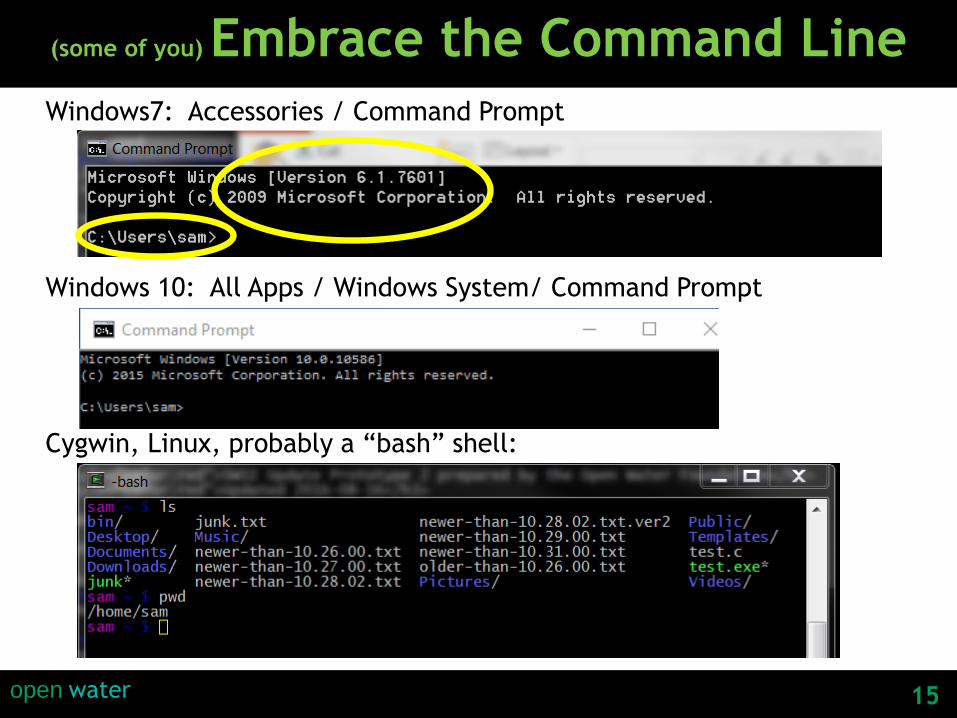
(some of you) Embrace the Command Line
Windows7: Accessories / Command Prompt
Windows 10: All Apps / Windows System/ Command Prompt
Cygwin, Linux, probably a “bash” shell:

16open water
(some of you) Embrace the API
API = Application Programming Interface
• Documented open standard for requesting and receiving data
• Integrates with software and allows for automation
• Forces publishers and consumers of data to understand the content
You should be asking: “Does it have a REST API?”
Input:http://someserver/some/path/to/data?query1=A&query2=B&format=excel
Output:Data in a format that you can use: text, csv, JSON,
XML, Excel, map layer
Simplest example: a URL that provides a data file

17open water
Wouldn’t it be nice if….?
• All R2CROSS datasets are georeferenced and
available for download?...even if no instream flow
right resulted?
• All useful spatial datasets are linearly referenced to
streams with stream mile?
• All useful datasets include attributes that allowed
them to be linked spatially and temporally for
analysis?
• Datasets are not always distributed as the “latest”
but have version dates and a history so that we can
understand trends?
• Datasets are publicly available for download?

18open water
Useful Concept: The “Snake” Diagram
http://www.nytimes.com/2010/04/27/world/27powerpoint.html

19open water
Google Traffic MapRed=bad, orange=a little bad, green=OK, but need to understand context of “bad”
So how does Google do it? Smart phone crowdsourced data. Resolution to ~300 feet?.
People are now familiar with these types of products.
Can stream conditions be similarly visualized?

20open water
National Hydrography Dataset (USGS)
http://viewer.nationalmap.gov/viewer/nhd.html?p=nhd
NHD = complicated
Simpler alternative:
Division of Water Resource’s
Source Water Route
Framework (SWRF)
http://cdss.state.co.us/GIS/Pages/AllGISData.aspx

21open water
Stream Mile Representation Framework from
South Platte/Metro Basin Implementation Plan
Stream mile + Excel = accessible data
E&R Attributes
Instream Flow Reaches
Projects & Methods
Stream Gages
Diversion Headgates
Organization Extent
Master Plans
and more…
22open water
Spatial Scale/Scope: Region/Stream Reach/Focus Area
• Basin = Water District/Division, HUC
• Stream Reach = Stream mile or landmark
range in basin
• Focus Areas that were used in SWSI & BIPs
Are they needed?
Focus area could instead be a basin (HUC)
Focus area could instead be a stream
reach indicated by stream miles or
landmark (many are already doing this).
23open water
Some Data Sources• CDSS: cdss.state.co.us
• CDSS map viewer: see above
• CWCB data viewer:
https://www.coloradodnr.info/H5V/?Viewer=cwcbmap
• DWR: water.state.co.us
• Open data portal: data.colorado.gov
• USGS NWIS: http://waterdata.usgs.gov/nwis
• RCC ACIS (climate): http://www.rcc-acis.org/
• NRCS: http://www.wcc.nrcs.usda.gov/web_service/awdb_web_service_landing.htm
• EPA: https://www3.epa.gov/storet/web_services.html
• CDSN (water quality): http://www.coloradowaterdata.org/
• CNHP: http://www.cnhp.colostate.edu/
• DataBasin.org
• Watershed coalitions, Northern Water, river districts, etc.
• data.openwaterfoundation.org

24open water
CWCB Data
How would I find data for CWCB environmental and
recreational, and stream restoration projects?
“I recommend directing them to CWCB for data related to the Non-Consumptive Needs Assessments and Basin priorities by stream or watershed. Beyond that, I recommend that watershed groups work within their own collaborative to assemble data important to their objectives in Stream Management and/or Watershed planning. This may include water quality data, USFS inventories (roads, culverts), CPW fish data, ecological data generated by local assessments, burn severity data, topography (survey),...”
http://cwcb.state.co.us/environment/non-consumptive-needs/Paes/main.aspx
http://cwcb.state.co.us/ENVIRONMENT/WATERSHED-PROTECTION-
RESTORATION/Pages/main.aspx

25open water
data.colorado.gov
http://www.edwardtufte.com/bboard/q-and-a-fetch-msg?msg_id=0002N4
Source for many “flat” datasets
and provides an open data platform
for distributing datasets
26open water
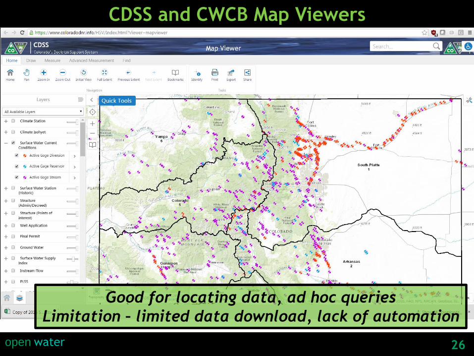
CDSS and CWCB Map Viewers
Good for locating data, ad hoc queries
Limitation – limited data download, lack of automation
27open water
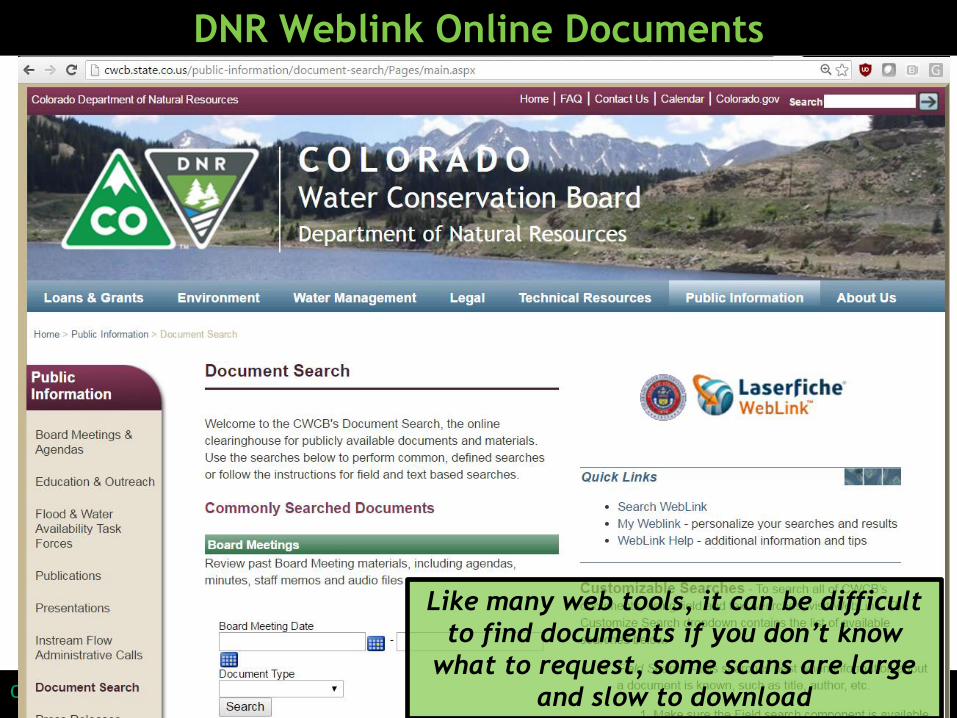
DNR Weblink Online Documents
Like many web tools, it can be difficult
to find documents if you don’t know
what to request, some scans are large
and slow to download

28open water
DataBasin.org
National-level
resource

29open water
data.openwaterfoundation.org
OWF is experimenting with
providing value-added
datasets to facilitate
complex analysis

30open water
Time Series Analysis and Automation – TSTool software

31open water
Summary• Keep it simple
• Don’t let technologies abuse you (but they will)
• Understand your data and process limitations
• Prototyping is OK, dead ends happen, but have a
roadmap so you know your destination
• Collaboration is easier with open standards and open
data
• Learn from others
• Try to be agile
“A river is more than an amenity. It is a treasure. It offers a necessity of life that must be rationed among those who have power over it.” –Supreme Court Justice Oliver Wendell Holmes, Jr. (quote from 1931)

32open water
Share ItThe content of this presentation is licensed under the Creative Commons Attribution NonCommercial License:
http://creativecommons.org/licenses/by-nc/4.0
openwaterfoundation.org