Embed Size (px)
Citation preview

STRUCTURAL AND STRATIGRAPHIC ARCHITECTURE OF WESTER N AUSTRALIA’S FRONTIER ONSHORE SEDIMENTARY BASINS: THE WESTERN OFFICER AND SOUTHER N CARNARVON BASINS L.K. Carr1, R.J. Korsch1, A.J. Mory2, R.M. Hocking2, S.K. Marshall1, R.D. Costelloe1, J. Holzschuh1, J.L. Maher1
1Geoscience Australia, GPO Box 378, Canberra, ACT 2601, Australia. 2Geological Survey Division, Department of Mines and Petroleum, Western Australia, 100 Plain Street, East Perth, WA 6044, Australia. Key words Carnarvon Basin, Officer Basin, seismic reflection, basin architecture Introduction The 5 year Onshore Energy Security Program (2007-2011) funded by the Australian Government was carried out by Geoscience Australia, in conjunction with State and Territory geological surveys. The program acquired deep seismic reflection data across several frontier sedimentary basins to provide regional sub-surface geological information, and stimulate petroleum exploration in onshore Australia. Here, we present data from the two seismic lines collected in Western Australia during 2011. The 487-km long Yilgarn–Officer–Musgrave (YOM) seismic line (11GA-YO1), which crossed the western Officer Basin in Western Australia, and the 259-km long Southern Carnarvon seismic line (11GA-SC1), which crossed the Gascoyne Platform and the Byro Sub-basin (Fig. 1). Officer Basin The Officer Basin covers about 525 000 km2 across South Australia and Western Australia, and is a component of the Centralian Superbasin (Fig. 1). The basin fill ranges from Neoproterozoic to Devonian and was deformed by the latest Neoproterozoic to earliest Cambrian Petermann Orogeny, the late Cambrian Delamarian Orogeny, and the Silurian–Carboniferous Alice Springs Orogeny. Geochemical evaluation of numerous minor oil and bitumen shows indicate the presence of at least one petroleum system in the basin (Ghori, 1998). Simeonova and Iasky (2005) demonstrated that the major deformational mechanism in the western Officer Basin was halotectonics, which may also have formed a variety of hydrocarbon traps. The interpretation of seismic line 11GA-YO1 (Fig. 2) is constrained stratigraphically by wells located on or close to the seismic line, including Yowalga 3, GSWA Empress 1/1A, BMR Westwood 1 and 2 and BMR Throssell 1. GSWA Empress 1/1A and Yowalga 3 reached depths of 1522 m and 4200 m respectively, and are about 20 km away from the seismic line: Kanpa 1A reached 3803 m. These three wells intersected a thick Neoproterozoic succession, including the Browne, Hussar and Kanpa formations. The mineral exploration bore NJD1 located about 100 km south of the seismic line intersected Browne Formation above Mesoproterozoic or Paleoproterozoic metasedimentary rocks, which are also intersected beneath the Officer Basin in Kanpa 1A and GSWA Lancer 1. Near the southwestern end of the seismic line, the interpretation is constrained by surface outcrops of the Archean Yilgarn Craton and Neoproterozoic Browne Formation. On the northeastern end of the seismic line outcrops of the Neoproterozoic Browne Formation and Townsend Quartzite dip to the west above the Mesoproterozoic basement. The northeastern margin was deformed by a younger deformational event, possibly the Alice Spring Orogeny. The Officer Basin was initially an extensional basin, with a mostly flat-lying sedimentary succession. The seismic line shows an asymmetric architecture with sedimentary succession thickening to the northeast towards the Musgrave Province to a maximum thickness of about 4600 m (Fig. 2). The northeastern margin is defined by a steep extensional growth fault that was active during the deposition of the lower sedimentary succession (Browne, Hussar and Kanpa formations). Several non-reflective areas imaged on the seismic section (Fig. 2) which, cut across the stratigraphy and are interpreted as salt diapirs or walls mobilised from salt horizons in the Browne Formation. The salt movement appears to be related to faulting during the Petermann Orogeny as well as Delamerian Orogeny. These orogenies created a prominent angular unconformity (Fig. 2) near the top of the Officer Basin succession. Above the unconformity, the Cambrian Table Hill Volcanics are imaged as two prominent reflections, defining the top and base of the volcanic package. Overlying this is a seismically non-reflective package, up to 1000 m thick, consisting mostly of Permian, Cretaceous and possibly even Cambro-Ordovician and Devonian sedimentary rocks, none of which can be resolved on the seismic (Fig. 2). In contrast to this interpretation, Simeonova and Iasky (2005, Fig. 14, section B-B’) describe four discreet zones in the Officer Basin including (from west to east): a shallow platform with an uninterrupted, mostly flat lying, stratigraphy; a thrusted zone with some salt movement; a zone where the salt has ruptured the stratigraphy; and an overthrusted zone in the east. The new seismic data shows that the southwest margin of the Musgrave Province is defined by an extensional fault, rather than a thrust, and that salt diapirs occur much further west than previously described. Southern Carnarvon Basin The Southern Carnarvon Basin covers an area of 188 000 km2, of which about 90 000 km2 is onshore (Fig. 1). Offshore the Northern Carnarvon Basin contains a thick Mesozoic succession that is the premier petroleum-producing province in Australia, whereas, onshore the Mesozoic succession is thin and mostly flat lying. The Southern Carnarvon seismic line 11GA-SC1 (Fig. 3) extends east–west across lower Paleozoic strata in the west (Gascoyne Platform), and the Permian depocentres of the Merlinleigh and Byro sub-basins in the east, separated by the Ajana Fault system. Major tectonic events, which have affected the basin, include mid-Carboniferous folding and faulting, Permian extension and Jurassic–Cretaceous continental breakup (Mory et al, 2003). The Byro Sub-basin has potential for both hydrocarbon and geothermal energy. Ghori (1999) found excellent to fair source-rock intervals in the Silurian Dirk Hartog Group and the Upper Devonian Gneudna Formation. Ghori (1999) showed that on the Gascoyne Platform to the north of the seismic line Devonian source rocks of the Gneudna Formation has Total Organic Carbon (TOC) content to of about 13%, further, source rocks within the Permian succession of the adjacent Merlinleigh Sub-basin have TOC up to 16% TOC (Mory et al, 2003). This interpretation indicates that these strata may extend into the Byro Sub-basin Constraints on the stratigraphy of the basin are provided by several wells, including Hamelin Pool 1 and 2, Yaringa 1, Woodleigh 1982-1 and GSWA Ballythanna 1 (Fig. 1). Hamelin Pool 2 and Yaringa 1, located 6 km and 14 km to the northwest of the seismic line, reached total depth in the upper part of the Ordovician Tumblagooda Sandstone, which also constrained the base lower of the Paleozoic section. Woodleigh 1982/01 located 4 km south of the line intersected 90 m of Cretaceous strata and 101 m of probable Lower Jurassic siliciclastic strata overlying carbonates of the Silurian Dirk Hartog Group (Iasky et al, 2001). GSWA Ballythanna 1 lies on the seismic line 11GA-SC1 and is about 2 km west of the Darling Fault. It intersected the Permian Keogh and Callytharra formations before reaching total depth in the Lyons Group. Permian outcrops and several water and coal-exploration boreholes, also help to constrain the interpretation. Seismic line 11GA-SC1 (Fig. 3) shows that the Byro Sub-basin consists of two, relatively thick half graben, bounded by the west-dipping Darling and Meeberrie Faults. Calculations from stacking velocities suggest that the sedimentary successions in the western and eastern half-graben are about 5600 m and 7100 m thick respectively. Two distinct sedimentary packages occur: a lower unit interpreted to range from the Ordovician Tumblagooda Sandstone to the Lower Devonian Kopke Sandstone, and an upper unit interpreted as Permian, separated from the lower unit by an angular unconformity. Faulting and tilting between the two units is attributed to tectonism related to the Alice Springs Orogeny. The Permian rocks show some thickening into both the Darling and Meeberrie faults and are interpreted as synextensional deposits. Both synthetic and antithetic faults are mapped in both the upper and lower successions were interpreted to relate to these extensional events. A deeper package of reflections below the eastern half graben (Fig. 3) is interpreted to be the Mesoproterozoic–Neoproterozoic Badgeradda Group, which crops out along the southern and northeastern margins of the Byro Sub-basin. To the west, the Permian sediments extend onto the eastern edge of the Gascoyne Platform as a relatively thin flat-lying sheet, which unconformably overlies tilted and faulted Paleozoic rocks (Fig. 3).

The western end of the seismic line crosses the Woodleigh impact structure, which is buried below a thin Jurassic to Cretaceous strata (Iasky et al., 2001). Low dips in the Ordovician – Lower Devonian rocks, to the west of a zone of down-to-the-east normal faults, indicate that the diameter of the impact structure is about 51 km, which is consistent with the eastward deterioration of reflections in seismic line W65G-003 15 km to the north. The diameter of the structure appears to closely match the distribution of the Lower Jurassic Woodleigh Formation, a siliciclastic lacustrine deposit up to 300 m thick (GSWA Woodleigh 2A), thereby suggesting an earliest Jurassic age for the structure. Conclusions New data collected as part of the Onshore Energy Security Program has increased our knowledge of the several onshore frontier regions. Seismic line 11GA-YO1 has shown an asymmetrical basin, deepening to the east, in which the sedimentary succession has been disrupted by salt diapirs, some of which extend to the surface. Seismic line 11GA-SC1 showed that the Byro Sub-basin consists of two relatively thick, half graben, bounded by west-dipping faults. Two distinct sedimentary successions separated by an unconformity are present in both half graben, in the west the seismic line crosses the Woodleigh impact structure. The new data provides insight into the structural architecture and stratigraphy of the poorly explored western Officer and southern Carnarvon Basins. Acknowledgements The authors would like to thank John Kennard and Irina Borissova for their reviews of the manuscript and Theo Chiotis for production of the figures. Published with permission of the Chief Executive Officer, Geoscience Australia, and the Director, Geological Survey of Western Australia. References GHORI, K. A. R., 1998—Petroleum source-rock potential and thermal history of the Officer Basin, Western Australia: Western Australia Geological Survey, Record 1998/3, 52p. GHORI, K. A. R., 1999—Silurian–Devonian petroleum source-rock potential and thermal history, Carnarvon Basin, Western Australia: Western Australia Geological Survey, Report 72, 88p. IASKY, R. P., MORY, A. J. and BLUNDELL, K. A., 2001—The geophysical interpretation of the Woodleigh impact structure, Southern Carnarvon Basin, Western Australia: Western Australia Geological Survey, Report 79, 41p. MORY, A. J., IASKY, R. P., and GHORI, K. A. R., 2003—A summary of the geological evolution and petroleum potential of the Southern Carnarvon Basin, Western Australia: Western Australia Geological Survey, Report 86, 26p. SIMEONOVA, A. P. and IASKY, R. P., 2005—Seismic mapping, salt deformation, and hydrocarbon potential of the central western Officer Basin, Western Australia: Western Australia Geological Survey, Report 98, 51p. Figure captions
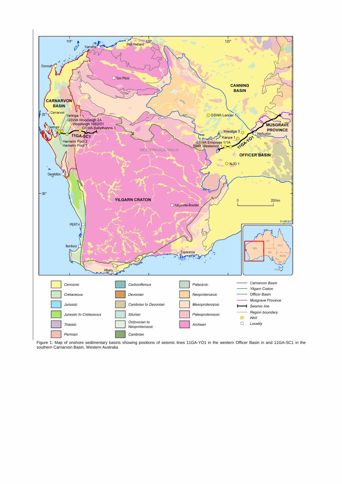
Figure 1: Map of onshore sedimentary basins showing positions of seismic lines 11GA-YO1 in the western Officer Basin in and 11GA-SC1 in the southern Carnarvon Basin, Western Australia

Figure 2: Geological interpretation of migrated seismic section 11GA-YO1 across the western Officer Basin, displayed with a vertical to horizontal scale of 1:4, assuming an average crustal velocity of 6000 m s-1.
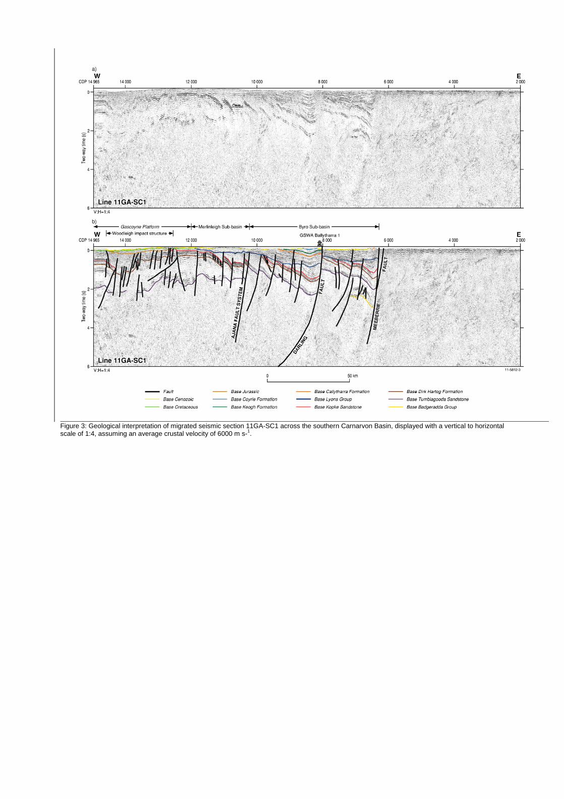
Figure 3: Geological interpretation of migrated seismic section 11GA-SC1 across the southern Carnarvon Basin, displayed with a vertical to horizontal scale of 1:4, assuming an average crustal velocity of 6000 m s-1.