Embed Size (px)
Citation preview
International Journal of Scientific and Research Publications, Volume 7, Issue 7, July 2017 126 ISSN 2250-3153
www.ijsrp.org
Structural and stratigraphic evaluation of Kashmir Basin
at Himalayan core Belt
Syed Muzyan Shahzad, Hanif Ullah, Umair Fakhar, Mirza Shahid Baig, Muhammad Ishfaque, Mohsin khan,
Hammad Tariq Janjuhah, Fahad Farooq, Tariq Haider, Abid Ali, Nazakat Ali
University of Azad Jammu and Kashmir Muzaffarabad Pakistan.
Abstract- As Hazara Kashmir Syntaxes is the part of Himalayan
Fold and thrust belt situated in sub- Himalayan and the studied
area lies in the southern part of the Hazara Kashmir Syntaxis
Pakistan. The Hazara Kashmir Syntax is an antiformal structure.
The core of syntaxis comprises of Himalayan molasse deposits.
These molasse deposits ranging from Early Miocene to Recent are
exposed in the area. This study deals with the structure and
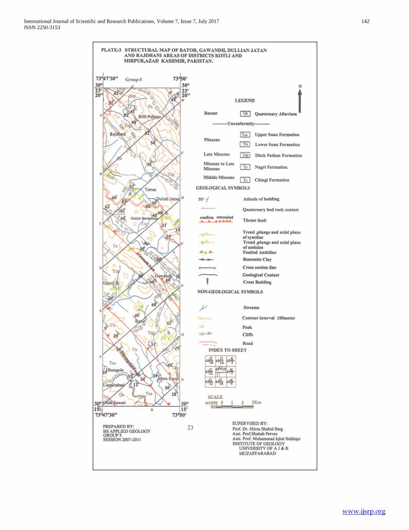
stratigraphy of Bator, Gawandh, Dhulian Jattan and Rajdhani
areas of Azad Kashmir and Pakistan. The Himalayan molasse
deposits are exposing in the southern Hazara Kashmir Syntaxis.
The study area includes The Middle Miocene to Recent molasse
sedimentary deposits are exposed in the project area. The exposed
sedimentary sequence includes the Chinji Formation, Nagri
Formation, Dhok Pathan Formation, Soan Formation and Recent
alluvium. The area is deformed into folds and faults due to
Himalayan orogeny. The major folds in study area are Palak
Syncline, Gawandh Anticline, Rajdhani Syncline and Nar Saniah
anticline. The folds are northwest southeast trending and northeast
or southwest vergent. These folds are closed in nature. The study
area consists of four major faults primarily Gawandh fault, Kotli
Sarsawah fault and Bajwal Banyan fault. Dhongolo fault is the
splay of the Kotli Sarsawah fault. Faults and folds are northwest
southeast trending and are related to Himalayan compression.
Index Terms- Syntaxis, Kashmir Basin, lithology, folds, faults
and plates.
I. INTRODUCTION
he study area is the part of Hazara Kashmir Syntaxis. It lies in
districts Kotli and Mirpur, Azad Kashmir, Pakistan. This area
includes Bator, Gawandh, Dhullian Jattan, and Rajdhani areas.
The area lies between longitudes 73° 47' 30'' to 73°50' 00'' E and
latitudes 33°15' 00'' to 33° 23'20'' N and lies on topographic sheet
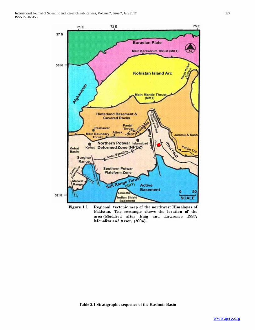
no 43 G /15 of the Survey of Pakistan (Fig 1.1, Plate 1). The
project is located in the southeastern part of the Hazara Kashmir
Syntaxes and is imbricated along Jhelum Fault, Riasi Fault, Punjal
Thrust and Main Boundary Thrust (Baig and Lawrence, 1987).
The western limb of the Hazara Kashmir Syntaxes terminated by
regional Jhelum Fault (Figure 1.1). The exposed sedimentary
sequence of the project area includes the molasse rocks sediments
of Siwalik Group. The stratigraphic sequence includes Chinji
Formation, Nagri Formation, Dhok Pathan Formation and the
Soan Formation. The age of these formation ranges from Middle
Miocene to Pliocene. The Recent alluvium overlies
unconformably on the earlier rock formation. The workers like
Ashraf et al. (1983), Wells and Gingerich (1987), and also
Geological Survey of Pakistan carried only regional geological
mapping and stratigraphic.
1. To prepare the geological and structural map of the
project area.
2. To prepare detail structural cross sections of the area.
3. To prepare β and π diagrams for structural analysis
of the area.
II. METHODOLOGY
The data acquired in 30 days field work Traverses were
made along and across the strike of the different rock units
(Plate1). The Brunton compass was used to measure the attitude
of different bedding planes of rock units the in study area. The
facing of rock units were determined on the basis of sedimentary
structures. The structural data is plotted on the stereonet and
presented in the tables. Cross-sectional profiles of structural and
stratigraphic sequence was constructed. Distinguished feature of
folds and faults have been recognized and with the help of this data
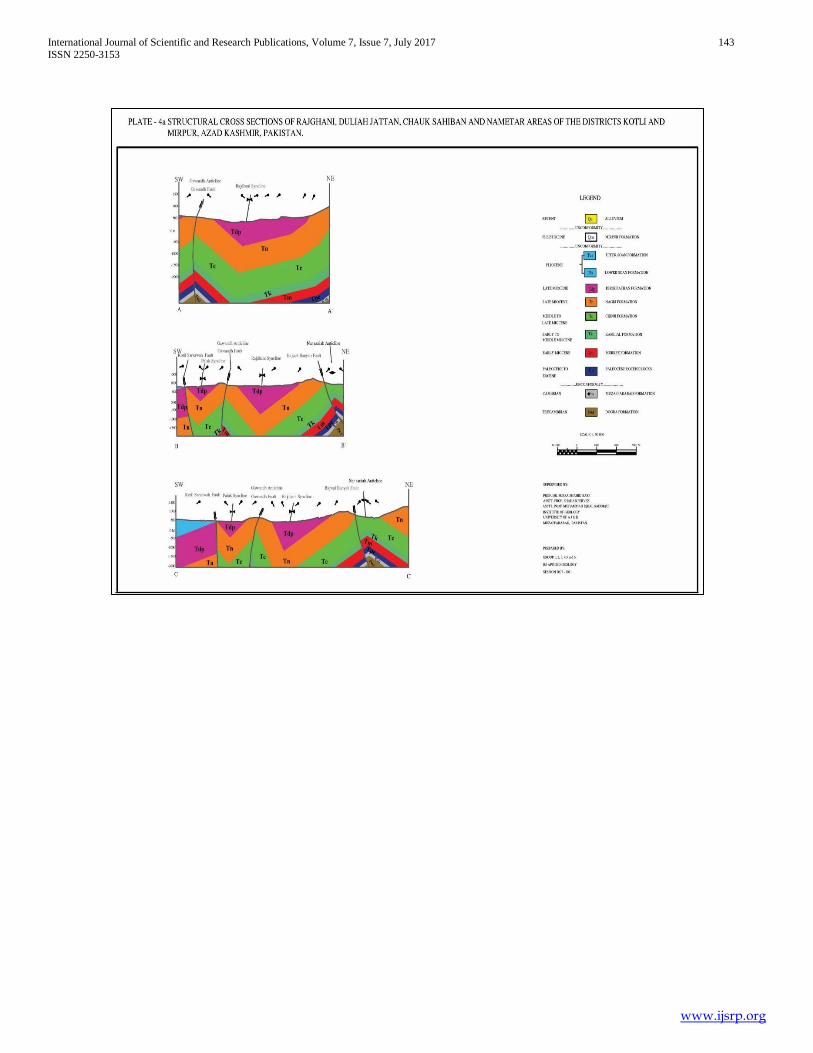
mapping has been accomplished i.e Traverse route Map (Plate 1)
Geological Map (Plate 2), Structural Map (Plate 3) and Structural
Cross-sections (4a, 4b, 4c, 4d, 4e, 4f, 4g and 4h).
T
International Journal of Scientific and Research Publications, Volume 7, Issue 7, July 2017 127
ISSN 2250-3153
www.ijsrp.org
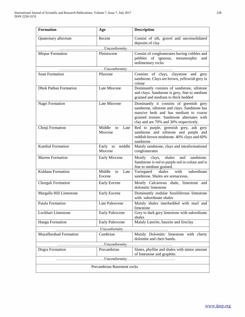
Table 2.1 Stratigraphic sequence of the Kashmir Basin
International Journal of Scientific and Research Publications, Volume 7, Issue 7, July 2017 128
ISSN 2250-3153
www.ijsrp.org
Formation Age Description
Quaternary alluvium Recent Consist of silt, gravel and unconsolidated
deposits of clay
…………………………….Unconformity…………………………….
Mirpur Formation Pleistocene Consist of conglomerates having cobbles and
pebbles of igneous, metamorphic and
sedimentary rocks
…………………………….Unconformity…………………………….
Soan Formation Pliocene Consists of clays, claystone and grey
sandstone. Clays are brown, yellowish grey in
colour
Dhok Pathan Formation Late Miocene Dominantly consists of sandstone, siltstone
and clays. Sandstone is grey, fine to medium
grained and medium to thick bedded
Nagri Formation Late Miocene Dominantly it consists of greenish grey
sandstone, siltstone and clays. Sandstone has
massive beds and has medium to coarse
grained texture. Sandstone alternates with
clay and are 70% and 30% respectively.
Chinji Formation Middle to Late
Miocene
Red to purple, greenish grey, ash grey
sandstone and siltstone and purple and
reddish brown mudstone. 40% clays and 60%
sandstone.
Kamlial Formation Early to middle
Miocene
Mainly sandstone, clays and intraformational
conglomerates
Murree Formation Early Miocene Mostly clays, shales and sandstone.
Sandstone is red to purple red in colour and is
fine to medium grained.
Kuldana Formation Middle to Late
Eocene
Variegated shales with subordinate
sandstone. Shales are arenaceous.
Chorgali Formation Early Eocene Mostly Calcareous shale, limestone and
dolomitic limestone
Margalla Hill Limestone Early Eocene Dominantly nodular fossiliferous limestone
with subordinate shales
Patala Formation Late Paleocene Mainly shales interbedded with marl and
limestone
Lockhart Limestone Early Paleocene Grey to dark grey limestone with subordinate
shales
Hangu Formation Early Paleocene Mainly Laterite, bauxite and fireclay
…………………………….Unconformity…………………………….
Muzaffarabad Formation Cambrian Mainly Dolomitic limestone with cherty
dolomite and chert bands.
……………………………...Unconformity…………………………….
Dogra Formation Precambrian Slates, phyllite and shales with minor amount
of limestone and graphite.
………………………………Unconformity………………………………
Precambrian Basement rocks
International Journal of Scientific and Research Publications, Volume 7, Issue 7, July 2017 129
ISSN 2250-3153
www.ijsrp.org
III. REGIONAL STRATIGRAPHY OF THE KASHMIR
BASIN
In Kashmir basin the stratigraphic units constitute the cover
sequence of Indian Plate. The early workers like (Wadia (1928),
Lydekker (1883), Wells and Gingerich (1987)) have established
regional stratigraphy of the area. The regional stratigraphy of
Kashmir Basin is presented in table 2.1.
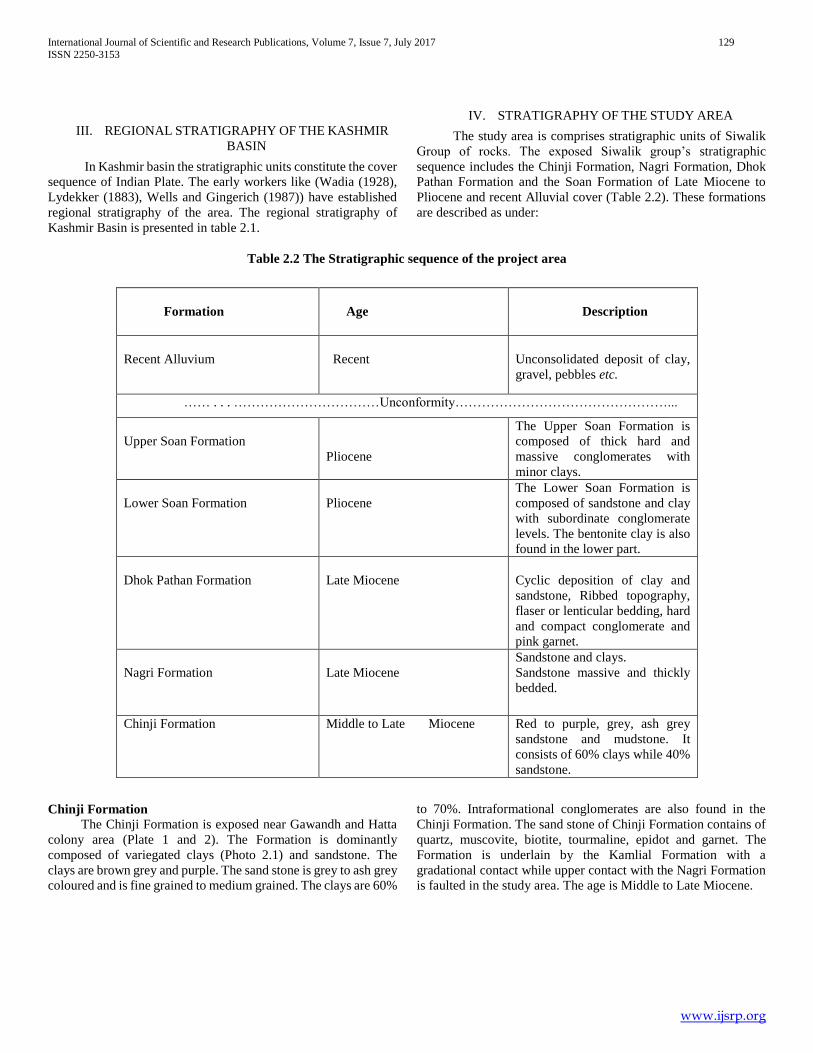
IV. STRATIGRAPHY OF THE STUDY AREA
The study area is comprises stratigraphic units of Siwalik
Group of rocks. The exposed Siwalik group’s stratigraphic
sequence includes the Chinji Formation, Nagri Formation, Dhok
Pathan Formation and the Soan Formation of Late Miocene to
Pliocene and recent Alluvial cover (Table 2.2). These formations
are described as under:
Table 2.2 The Stratigraphic sequence of the project area
Chinji Formation
The Chinji Formation is exposed near Gawandh and Hatta
colony area (Plate 1 and 2). The Formation is dominantly
composed of variegated clays (Photo 2.1) and sandstone. The
clays are brown grey and purple. The sand stone is grey to ash grey
coloured and is fine grained to medium grained. The clays are 60%
to 70%. Intraformational conglomerates are also found in the
Chinji Formation. The sand stone of Chinji Formation contains of
quartz, muscovite, biotite, tourmaline, epidot and garnet. The
Formation is underlain by the Kamlial Formation with a
gradational contact while upper contact with the Nagri Formation
is faulted in the study area. The age is Middle to Late Miocene.
Formation
Age
Description
Recent Alluvium
Recent
Unconsolidated deposit of clay,
gravel, pebbles etc.
…… . . . ……………………………Unconformity…………………………………………...
Upper Soan Formation
Pliocene
The Upper Soan Formation is
composed of thick hard and
massive conglomerates with
minor clays.
Lower Soan Formation
Pliocene
The Lower Soan Formation is
composed of sandstone and clay
with subordinate conglomerate
levels. The bentonite clay is also
found in the lower part.
Dhok Pathan Formation
Late Miocene
Cyclic deposition of clay and
sandstone, Ribbed topography,
flaser or lenticular bedding, hard
and compact conglomerate and
pink garnet.
Nagri Formation
Late Miocene
Sandstone and clays.
Sandstone massive and thickly
bedded.
Chinji Formation Middle to Late Miocene Red to purple, grey, ash grey
sandstone and mudstone. It
consists of 60% clays while 40%
sandstone.

International Journal of Scientific and Research Publications, Volume 7, Issue 7, July 2017 130
ISSN 2250-3153
www.ijsrp.org
Photo 2.1 Photograph showing different clay and grit level in Chinji Formation. Photograph facing Northeast (Station no. PR-
1; Plate 1).
2.3.2 Nagri Formation
The Nagri Formation is exposed in our project area in
Gawandh and Billi Puhrian areas (Plate 1 and 2). The Nagri
Formation is mainly composed of sandstone and clays. The fresh
colour of sandstone is greenish grey and weathered colour is dark
grey to brownish grey. The sand stone is medium to coarse grain,
and at places bluish grey and dull red. The sandstone in Nagri
Fornation is 60% to 70%, while some parts of the Nagri Formation
have 80% sandstone with subordinate clays. The characteristic
feature of Nagri sandstone is salt and pepper texture. The shale is
yellowish, reddish and blackish. The conglomerate layers are also
present in the Formation having pebbles and gravels of older rocks
like punjal volcanic and quartzite. The volcanic clasts are present
in upper part of the Nagri Formation. The cross bedding (Photo
2.2) and load casts are the sedimentary structure observed in the
Nagri Formation. The lower contact with the Chinji Formation is
faulted while the upper contact with the Dhok Pathan Formation
is gradational in the study area. The age of Nagri Formation is Late
Miocene.
Photo 2.2 Photograph showing cross bedding in sand stone of Nagri Formation. Photograph facing northeast (Station no. BP -
3; Plate 1)
International Journal of Scientific and Research Publications, Volume 7, Issue 7, July 2017 131
ISSN 2250-3153
www.ijsrp.org
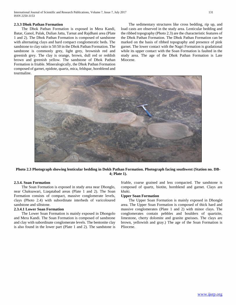
2.3.3 Dhok Pathan Formation
The Dhok Pathan Formation is exposed in Mera Kandi,
Batar, Ganol, Palak, Dulian Jatta, Tarnat and Rajdhani area (Plate
1 and 2). The Dhok Pathan Formation is composed of sandstone
with alternating clays and hard compact conglomeratic beds. The
sandstone to clay ratio is 50:50 in the Dhok Pathan Formation. The
sandstone is commonly grey, light grey, brownish red and
greenish grey. The clay is orange, brown, dull red or reddish
brown and greenish yellow. The sandstone of Dhok Pathan
Formation is friable. Mineralogically, the Dhok Pathan Formation
composed of garnet, epidote, quartz, mica, feldspar, hornblend and
tourmaline.
The sedimentary structures like cross bedding, rip up, and
load casts are observed in the study area. Lenticular bedding and
the ribbed topography (Photo 2.3) are the characteristic features of
the Dhok Pathan Formation. The Dhok Pathan Formation can be
marked on the basis of ribbed topography and presence of pink
garnet. The lower contact with the Nagri Formation is gradational
while its upper contact with the Soan Formation is faulted in the
study area. The age of the Dhok Pathan Formation is Late
Miocene.
Photo 2.3 Photograph showing lenticular bedding in Dokh Pathan Formation. Photograph facing southwest (Station no. DB-
4; Plate 1).
2.3.4. Soan Formation
The Soan Formation is exposed in study area near Dhonglo,
near Chaksawari, Liaqatabad areas (Plate 1 and 2). The Soan
Formation consists of compact, massive conglomerate levels,
clays (Photo 2.4) with subordinate interbeds of varicoloured
sandstone and siltstone.
2.3.4.1 Lower Soan Formation
The Lower Soan Formation is mainly exposed in Dhongolo
and Mera Kandi. The Soan Formation is composed of sandstone
and clay with subordinate conglomerate levels. The bentonite clay
is also found in the lower part (Plate 1 and 2). The sandstone is
friable, coarse grained and less compacted. The sandstone is
composed of quartz, biotite, hornblend and garnet. Clays are
khaki.
Upper Soan Formation The Upper Soan Formation is mainly exposed in Dhonglo
area. The Upper Soan Formation is composed of thick hard and
massive conglomerates (Plate 1 and 2) with minor clays. The
conglomerates contain pebbles and boulders of quartzite,
limestone, cherty dolomite and granite gneisses. The clays are
brown, yellowish and gray.) The age of the Soan Formation is
Pliocene.
International Journal of Scientific and Research Publications, Volume 7, Issue 7, July 2017 132
ISSN 2250-3153
www.ijsrp.org
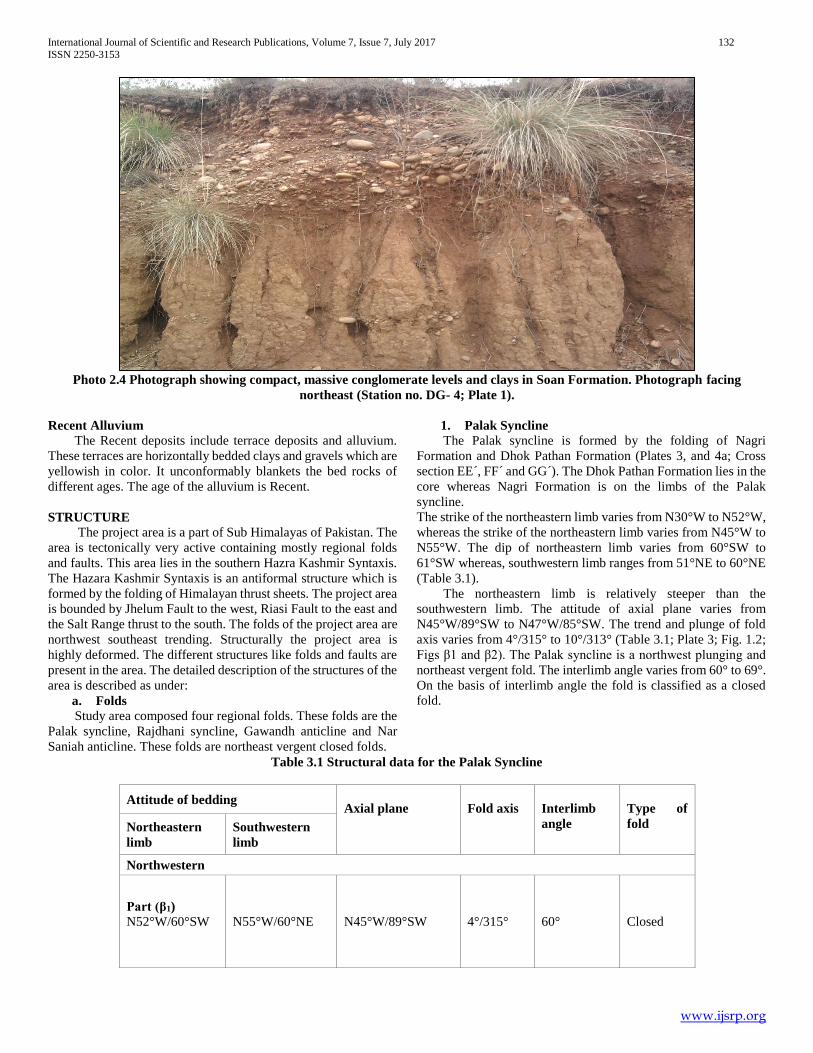
Photo 2.4 Photograph showing compact, massive conglomerate levels and clays in Soan Formation. Photograph facing
northeast (Station no. DG- 4; Plate 1).
Recent Alluvium
The Recent deposits include terrace deposits and alluvium.
These terraces are horizontally bedded clays and gravels which are
yellowish in color. It unconformably blankets the bed rocks of
different ages. The age of the alluvium is Recent.
STRUCTURE The project area is a part of Sub Himalayas of Pakistan. The
area is tectonically very active containing mostly regional folds
and faults. This area lies in the southern Hazra Kashmir Syntaxis.
The Hazara Kashmir Syntaxis is an antiformal structure which is
formed by the folding of Himalayan thrust sheets. The project area
is bounded by Jhelum Fault to the west, Riasi Fault to the east and
the Salt Range thrust to the south. The folds of the project area are
northwest southeast trending. Structurally the project area is
highly deformed. The different structures like folds and faults are
present in the area. The detailed description of the structures of the
area is described as under:
a. Folds
Study area composed four regional folds. These folds are the
Palak syncline, Rajdhani syncline, Gawandh anticline and Nar
Saniah anticline. These folds are northeast vergent closed folds.
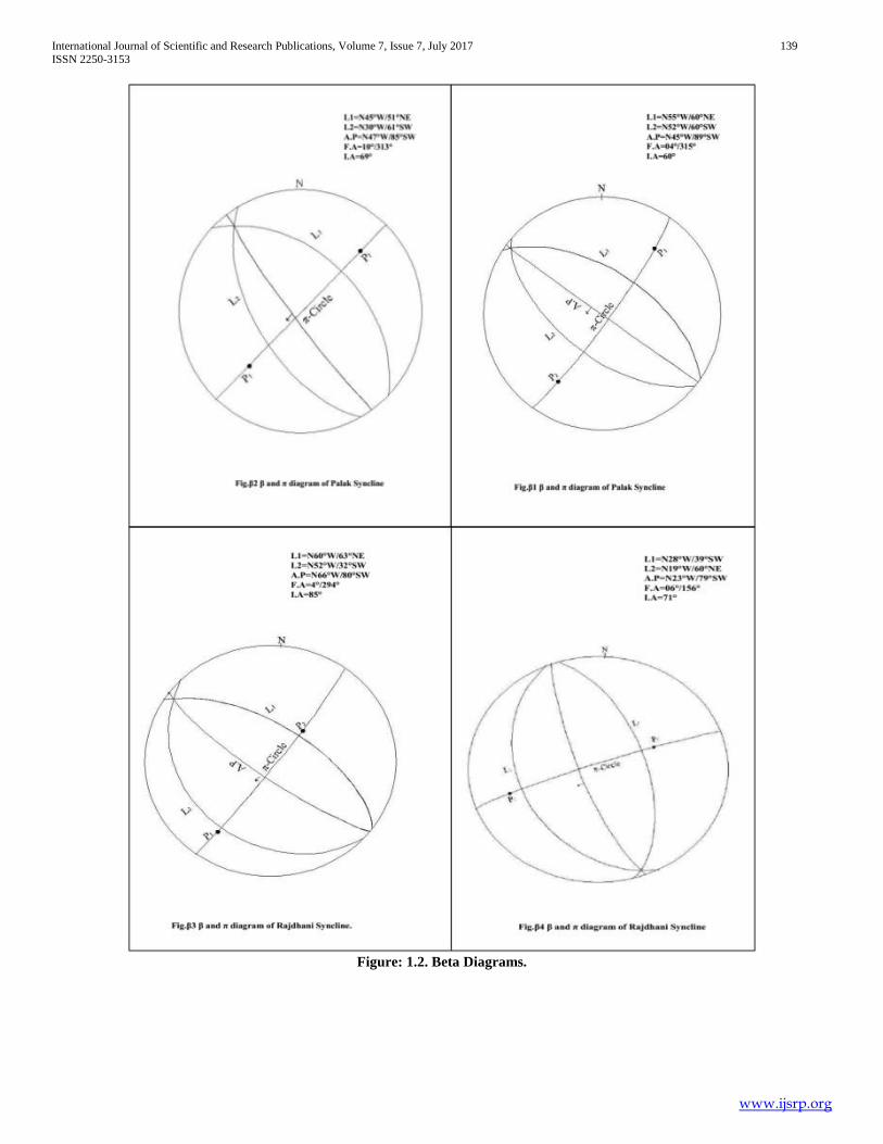
1. Palak Syncline
The Palak syncline is formed by the folding of Nagri
Formation and Dhok Pathan Formation (Plates 3, and 4a; Cross
section EE´, FF´ and GG´). The Dhok Pathan Formation lies in the
core whereas Nagri Formation is on the limbs of the Palak
syncline.
The strike of the northeastern limb varies from N30°W to N52°W,
whereas the strike of the northeastern limb varies from N45°W to
N55°W. The dip of northeastern limb varies from 60°SW to
61°SW whereas, southwestern limb ranges from 51°NE to 60°NE
(Table 3.1).
The northeastern limb is relatively steeper than the
southwestern limb. The attitude of axial plane varies from
N45°W/89°SW to N47°W/85°SW. The trend and plunge of fold
axis varies from 4°/315° to 10°/313° (Table 3.1; Plate 3; Fig. 1.2;
Figs β1 and β2). The Palak syncline is a northwest plunging and
northeast vergent fold. The interlimb angle varies from 60° to 69°.
On the basis of interlimb angle the fold is classified as a closed
fold.
Table 3.1 Structural data for the Palak Syncline
Attitude of bedding
Axial plane
Fold axis
Interlimb
angle
Type of
fold Northeastern
limb
Southwestern
limb
Northwestern
Part (β1)
N52°W/60°SW
N55°W/60°NE N45°W/89°SW 4°/315° 60° Closed
International Journal of Scientific and Research Publications, Volume 7, Issue 7, July 2017 133
ISSN 2250-3153
www.ijsrp.org
Southeastern
Part (β2)
N30°W/61°SW
N45°W/51°NE
N47°W/85ºSW 10°/313° 69° Closed
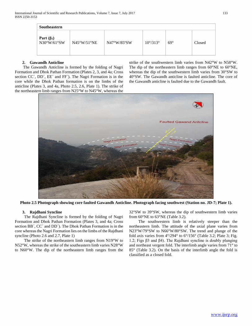
2. Gawandh Anticline
The Gawandh Anticline is formed by the folding of Nagri
Formation and Dhok Pathan Formation (Plates 2, 3, and 4a; Cross
section CC´, DD´, EE´ and FF´). The Nagri Formation is in the
core while the Dhok Pathan formation is on the limbs of the
anticline (Plates 3, and 4a, Photo 2.5, 2.6, Plate 1). The strike of
the northeastern limb ranges from N25°W to N45°W, whereas the
strike of the southwestern limb varies from N42°W to N58°W.
The dip of the northeastern limb ranges from 60°NE to 60°NE,
whereas the dip of the southwestern limb varies from 30°SW to
40°SW. The Gawandh anticline is faulted anticline. The core of
the Gawandh anticline is faulted due to the Gawandh fault.
Photo 2.5 Photograph showing core faulted Gawandh Anticline. Photograph facing southwest (Station no. JD-7; Plate 1).
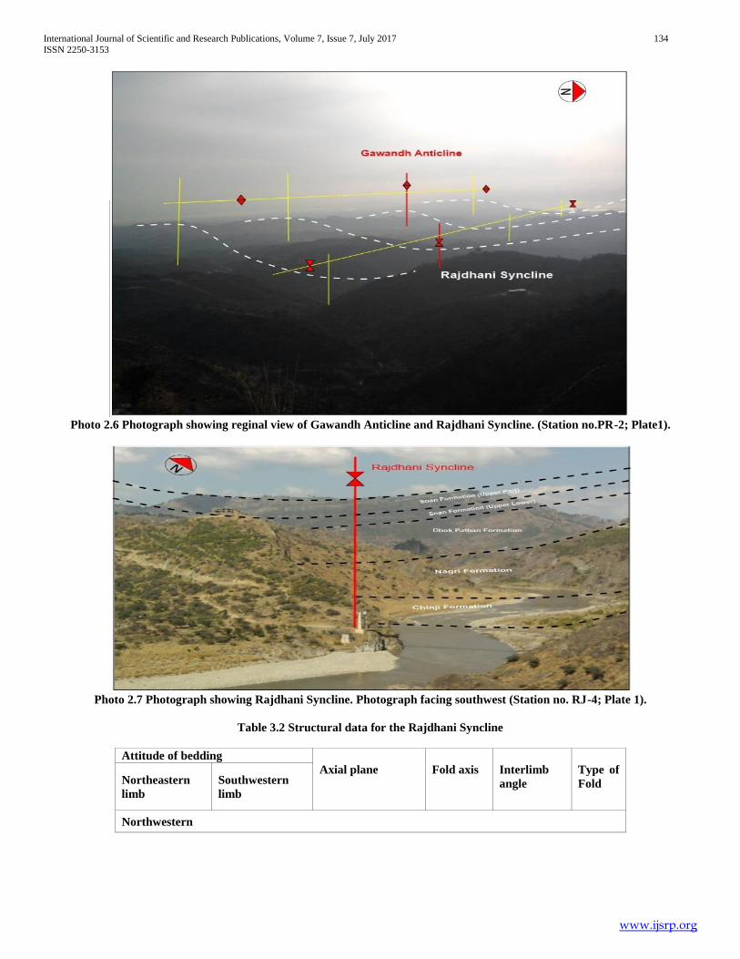
3. Rajdhani Syncline
The Rajdhani Syncline is formed by the folding of Nagri
Formation and Dhok Pathan Formation (Plates 3, and 4a; Cross
section BB´, CC´ and DD´). The Dhok Pathan Formation is in the
core whereas the Nagri Formation lies on the limbs of the Rajdhani
syncline (Photo 2.6 and 2.7, Plate 1)
The strike of the northeastern limb ranges from N19°W to
N52°W, whereas the strike of the southeastern limb varies N28°W
to N60°W. The dip of the northeastern limb ranges from the
32°SW to 39°SW, whereas the dip of southwestern limb varies
from 60°NE to 63°NE (Table 3.2).
The southwestern limb is relatively steeper than the
northeastern limb. The attitude of the axial plane varies from
N23°W/79°SW to N66°W/80°SW. The trend and plunge of the
fold axis varies from 4°/294° to 6°/156° (Table 3.2; Plate 3; Fig.
1.2; Figs β3 and β4). The Rajdhani syncline is doubly plunging
and northeast vergent fold. The interlimb angle varies from 71° to
85° (Table 3.2). On the basis of the interlimb angle the fold is
classified as a closed fold.
International Journal of Scientific and Research Publications, Volume 7, Issue 7, July 2017 134
ISSN 2250-3153
www.ijsrp.org
Photo 2.6 Photograph showing reginal view of Gawandh Anticline and Rajdhani Syncline. (Station no.PR-2; Plate1).
Photo 2.7 Photograph showing Rajdhani Syncline. Photograph facing southwest (Station no. RJ-4; Plate 1).
Table 3.2 Structural data for the Rajdhani Syncline
Attitude of bedding
Axial plane
Fold axis
Interlimb
angle
Type of
Fold Northeastern
limb
Southwestern
limb
Northwestern
International Journal of Scientific and Research Publications, Volume 7, Issue 7, July 2017 135
ISSN 2250-3153
www.ijsrp.org
Part (β3)
N52°W/32°SW
N60°W/63°NE N66°W/80°SW 4°/294° 85° Closed
Southeastern
Part (β4)
N28°W/39°SW
N19°W/60°NE
N23°W/79°SW
6°/156°
71°
Closed
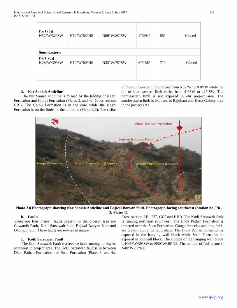
4. Nar Saniah Anticline
The Nar Saniah anticline is formed by the folding of Nagri
Formation and Chinji Formation (Plates 3, and 4a; Cross section
BB´). The Chinji Formation is in the core while the Nagri
Formation is on the limbs of the anticline (Photo 2.8). The strike
of the southwestern limb ranges from N32°W to N38°W while the
dip of southwestern limb varies from 41°SW to 42° SW. The
northeastern limb is not exposed in our project area. The
southwestern limb is exposed in Rajdhani and Hatta Colony area
in the project area.
Photo 2.8 Photograph showing Nar Saniah Anticline and Bajwal Banyan fault. Photograph facing southwest (Station no. PR-
3; Plates 1).
b. Faults
There are four major faults present in the project area are
Gawandh Fault, Kotli Sarsawah fault, Bajwal Banyan fault and
Dhonglo fault. These faults are reverse in nature.
1. Kotli Sarsawah Fault
The Kotli Sarsawah Fault is a reverse fault running northwest
southeast in project area. The Kotli Sarsawah fault is in between
Dhok Pathan Formation and Soan Formation (Plates 3, and 4a;
Cross section EE´, FF´, GG´ and HH´). The Kotli Sarsawah fault
is running northeast southwest. The Dhok Pathan Formation is
thrusted over the Soan Formation. Gouge, breccias and drag folds
are present along the fault plane. The Dhok Pathan Formation is
exposed in the hanging wall block while Soan Formation is
exposed in footwall block. The attitude of the hanging wall block
is N45°W/39°SW to N50°W/48°NE. The attitude of fault plane is
N48°W/85°NE.

International Journal of Scientific and Research Publications, Volume 7, Issue 7, July 2017 136
ISSN 2250-3153
www.ijsrp.org
Photo 2.9 Photograph showing Kotli Sarsawah fault. Photograph facing southwest (Station no. MK-8; Plate 1)
2. Gawandh Fault
It is the major fault passing through the project area which is
reverse in nature. The Gawandh fault is a regional is
intraformational fault passing through the Nagri Formation. The
Gawandh fault cuts the core of Gawandh anticline. The
northeastern limb of Gawandh anticline is thrusted over the
southwestern limb (Plates 2, 3, and 4a; Cross section CC´, DD´,
EE´ and FF´). The gouge and breccias are visible along the fault
in the project area (Photo 2.10). It is passing through Gawandh
area. The Gawandh fault is running northeast southwest. The
attitude of hanging wall is N23°W/60°NE to N48°W/40°NE while
the attitude of the foot wall is N39°W/40°SW to N50°W/60°SW.
The attitude of fault plane is N43°W/80°NE.
Photo 2.10 Photograph showing intraformational Gawandh fault. Photograph facing northeast (Station no. GL-2; Plate 1)
3. Bajwal Banyan Fault
The Bajal Banyan fault is regional fault passing through the
field area. The Chinji Formation is thrusted over the Nagri
Formation along the Bajwal Banyan fault (Plates 2, 3, and 4a;
cross section BB´). The fault is passing through the southwestern
limb of the Nar Saniah anticline (Photo 2.8). The Bajwal fault is
running northeast southwest. The Chinji Formation is exposed in
the hanging wall while Nagri Formation exposed in the footwall.

International Journal of Scientific and Research Publications, Volume 7, Issue 7, July 2017 137
ISSN 2250-3153
www.ijsrp.org
The attitude of the footwall is N32°W/40°SW while the attitude of
hanging wall block is N38°W/42°SW. The attitude of fault plane
is N40°W/70°NE. The fault is reverse in nature.
4. Dhonglo Fault
The Dhonglo fault is a splay fault of Kotli Sarsawa fault. It
is a reverse fault which has thrusted the lower part of the Soan
Formation over the upper part of the Soan Formation (Plates 2, 3,
and 4a; Cross section FF´, GG´ and HH´). The lower part of the
Soan Formation acts as hanging wall while the upper part is the
foot wall (Photo 2.11). The attitude of hanging wall block is
N45°W/5°SW to N48°W/10°SW while the attitude of footwall
block is N40°W/12°SW to N50°W/24°SW. The attitude of the
fault plane is N45°W/80°NE.
Photo 2.11 Photograph showing Dhonglo Fault between Soan Formation upper and lower part. Photograph facing southwest
(Station no. MK -1; Plate 1).
V. CONCLUSION
The project area lies in the southern part of Hazara Kashmir
Syntaxis. The project area is comprised thick cover of sedimentary
rocks of Himalayan molasse deposits. The molasses sequence
exposed in the area includes the Chinji Formation, Nagri
Formation, Dhok Pathan Formation and the Soan Formation.
The project area is highly deformed and regional folds and
faults are present in the area. The faults are mainly thrust faults
and northwest-southeast trending. The folds are tight to closed and
southwest or northeast vergent.
The major folds in the area are Palak Syncline, Gawandh
Anticline, Rajdhani Syncline and Nar Saniah Anticline.
The major faults in the area are mainly Gawandh Fault, Kotli
Sarsawa Fault, Bajwal Banyan Fault and Dhonglo Fault.
VI. DISCUSSION
The project area lies along the so thern part of the Hazara-
Kashmir Syntaxis in the sub-Himalaya of Pakistan which is
developed after the Tertiary collision of the Indian and Eurasian
Plates (Bossartet al., 1988). The south and southwestern part of
the Hazara Kashmir Syntaxis is imbricted along Panjal thrust,
MBT and Salt Range thrust (Baig and Lawrenece, 1987). The
western limb of the Hazara Kashmir Syntaxis is displaced by left
laterial strike slip Jhelum Fault. The core of the the syntaxis is
highly deformed.
The sedimentary rocks are exposed in the area range in age
from Middle to Late Miocene to Recent. These include the Chinji
Formation, Nagri Formation, Dhok Pathan Formation, Soan
Formation and Recent Alluvium.
The area is highly deformed into large scale folds and faults
due to stresses produced by the tectonic activities. The major folds
of the area are the Rajdhni syncline, Gawandh anticline, Palak
syncline, and Nar saniah anticline.
The Rajdhani syncline is formed by the folding of Dhok
Pathan Formation and Nagri Formation. The Dhok Pathan
Formation is in the core where as Nagri Formation lies on limbs.
The southwestern limb is relatively steeper than the northeastern
limb. It is northeast vergent and doubly plunging fold.
The Gawandh anticline is formed by the folding of the Nagri
Formation and Dhok Pathan Formation. The Nagri Formation is
in the core while the Dhok Pathan Formation is on the limbs. The
core of the Gawandh anticline is faulted and cut by the Gawandh
Fault. The Gawandh anticline is northwest southeast trending and
northeast vergent Fold.
The Palak Syncline is formed by the folding of Dhok Pathan
Formation and Nagri Formation. Dhok Pathan Formation is in the
core while the Nagri Formation lies on the northeastern limb. The
southwestren limb is cut by the Kotli Sarsawah Fault due to which
Soan Formation is thrusted over the Dhok Pathan. The Palak
International Journal of Scientific and Research Publications, Volume 7, Issue 7, July 2017 138
ISSN 2250-3153
www.ijsrp.org
Syncline is northwest southeast trending and northeast vergent
Fold.
The Nar-Saniah anticline is formed by the folding of Nagri
Formation. The vergence of the fold is north or southwest limb.
The Nar- Saniah anticline is a faulted anticline. The southwestern
limb of the anticline is cut by Bajwal –Banyan fault.
The major faults are the Kotli Sarsawa fault, Gawandh fault,
Bajwal Banyan fault and Dhonglo fault. The kotli Sarsawa fault is
a reverse fault which separates upper part of the Soan Formation
from the lower part of the Dhok Pathan formation. The Dhok
Pathan Formation lies in hanging wall and Soan Formation in foot
wall of the Kotli Sarsawa Fault. The Gawandh fault is reverse fault
marked between the upper between upper and lower part of the
Nagri Formation. The lower part of the Nagri Formation lies in the
hanging wall and upper part of Nagri Formation in foot wall of the
Gawandh Fault.
The Bajwal Banyan fault is a reverse fault between Chinji
Formation and the Nagri Formation in which Chinji Formation is
thrusted over the Nagri Formation. The Chinji Formation lies in
the hanging wall and Nagri Formation in foot wall of the Bajwal
Banyan Fault. The Dhonglo fault is also reverse fault in which
lower part of the Soan Formation is thrusted over the upper Soan
formation in the project area. The primary sedimentary structures
like load casts, ripple marks and cross bedding are present in the
study area.
Acknowledgement
I don’t have appropriate words to express my deepest sense
of gratitude to Almighty Allah Whose blessing did not let me
deviate from the right direction even through trials and
tribulations. I pay the tribute to the Holy Prophet Hazrat
Muhammad (PBUH) for enlighting our conscious. All the every
respect is for the Holy Prophet Who enables us to recognize our
Creator. I am grateful to express deepest gratitude to my project
supervisor honorable Prof. Dr. Mirza Shahid Baig and Prof.
Shahab Pervez for his student friendly attitude and precious
advices in context of my project. I’m especially grateful to my
Father and brother’s support and wonderful thanks to my research
fellows.
REFERENCES
[1] Ashraf, M., Chaudhary, M.N., and Qureshi, K. A., 1983, Stratigraphy of Kotli area of Azad Kashmir and its correlation with standard areas of Pakistan: Kashmir Jour. Geol., V. 1, P. 19-30.
[2] Baig, M. S., and Lawrence, R. D., 1987, Precambrian to Early Paleozoic orogenesis in the Himalaya: Kashmir Jour. Geol. V. 5, P. 1-22.
[3] Bossart, P., Dietrich, D., Greco, A., Ottigcr, R. & Ramsay, J.G., 1988. The tectonic structure ofthe Hazara-Kashmir syntaxis, southern Himalaya, Pakistan. Tectonics 7,273-297.
[4] Lydekker, R., 1883, Notes on the geology of the PirPanjal and neighbourring district:Rec .Geol.Surv,India,V.9,155P.
[5] Wadia, D. N., 1928. The geology of the Poonch State (Kashmir) and adjacent portion of the Punjab: Indian Geol. Surv.Mem., V. 51, P. 185-370.
[6] Wells, N.A., Gingerich, P.D., 1987.Paleo environmental interpretation of Paleogene strata near Kotli, Azad Kashmir, NortheasternPakistan. Kashmir Journal of Geology, 5, 23- 42.
AUTHORS
First Author – Syed Muzyan Shahzad, BS (hons) Applied
Geology, University of Azad Jammu & Kashmir, Muzaffarabad,
Pakistan.
Email address: [email protected]
Second Author –Hanif Ullah, BS (hons) Applied Geology,
University of Azad Jammu & Kashmir, Muzaffarabad, Pakistan.
Email address: [email protected]
Third Author –Umair Fakhar, BS (hons) Applied Geology,
University of Azad Jammu & Kashmir, Muzaffarabad, Pakistan.
Email address: [email protected]
International Journal of Scientific and Research Publications, Volume 7, Issue 7, July 2017 139
ISSN 2250-3153
www.ijsrp.org
Figure: 1.2. Beta Diagrams.

International Journal of Scientific and Research Publications, Volume 7, Issue 7, July 2017 140
ISSN 2250-3153
www.ijsrp.org

International Journal of Scientific and Research Publications, Volume 7, Issue 7, July 2017 141
ISSN 2250-3153
www.ijsrp.org
International Journal of Scientific and Research Publications, Volume 7, Issue 7, July 2017 142
ISSN 2250-3153
www.ijsrp.org
International Journal of Scientific and Research Publications, Volume 7, Issue 7, July 2017 143
ISSN 2250-3153
www.ijsrp.org
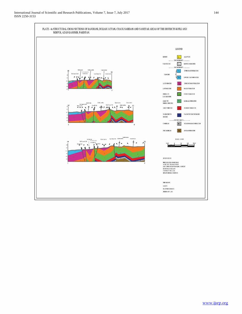
International Journal of Scientific and Research Publications, Volume 7, Issue 7, July 2017 144
ISSN 2250-3153
www.ijsrp.org

International Journal of Scientific and Research Publications, Volume 7, Issue 7, July 2017 145
ISSN 2250-3153
www.ijsrp.org