Embed Size (px)
Citation preview
Earthquakes and Structures, Vol. 9, No. 1 (2015) 93-109
DOI: http://dx.doi.org/10.12989/eas.2015.9.1.093 93
Copyright © 2015 Techno-Press, Ltd.
http://www.techno-press.org/journals/eas&subpage=7 ISSN: 2092-7614 (Print), 2092-7622 (Online)
Structural damage distribution induced by Wenchuan Earthquake on 12th May, 2008
Junfeng Jia1,2, Nianhua Song1,2, Zigang Xu1,2, Zizhao He3 and Yulei Bai4
1Key Laboratory of Urban Security and Disaster Engineering of Ministry of Education,
Beijing University of Technology, Beijing 100124, China 2Beijing Collaborative Innovation Center for Metropolitan Transportation, Beijing 100124, China
3Department of Civil and Environmental Engineering, University of California, Los Angeles, USA
4Department of Civil and Environmental Engineering, Hong Kong, Polytechnic University, China
(Received October 12, 2014, Revised December 16, 2014, Accepted December 30, 2014)
Abstract. Based on the reconnaissance of buildings in Dujiangyan City during 2008 Wenchuan earthquake,
China, structural damage characteristics and the spatial distribution of structural damage are investigated,
and the possible reasons for the extraordinary features are discussed with consideration of the influence of
urban historical evolution and spatial variation of earthquake motions. Firstly, the urban plan and typical
characteristics of structural seismic damage are briefly presented and summarized. Spatial distribution of
structural damage is then comparatively analyzed by classifying all surveyed buildings in accordance with
different construction age, considering the influence of seismic design code on urban buildings. Finally, the
influences of evolution of seismic design code, topographic condition, local site and distance from fault
rupture on spatial distribution of structural damage are comprehensively discussed. It is concluded that
spatial variation of earthquake motions, resulting from topography, local site effect and fault rupture, are
very important factor leading to the extraordinary spatial distribution of building damage except the
evolution of seismic design codes. It is necessary that the spatial distribution of earthquake motions should
be considered in seismic design of structures located in complicated topography area and near active faults.
Keywords: Wenchuan earthquake; spatial distribution; building damage; near-fault earthquake;
topography
1. Introduction
The Wenchuan Earthquake, which took place on May 12th, 2008, is the most severe earthquake
ever happened in China since the 1976 Tangshan Earthquake. The earthquake is caused by the
fracture of the Longmenshan fault due to the collision between two tectonic plates, the Indian plate
and the Eurasian (comprising the continents of Europe and Asia) plate. The epicenter of
Whenchuan earthquake is located in Wenchuan County (31.0°N, 103.4°E). The principal
earthquake lasts for nearly 2 minutes with seismological surface fault of nearly 300km long and
the focal depth of approximately 10 km. The earthquake causes severe casualties and property
Corresponding author, Assistant Professor, E-mail: [email protected]
Junfeng Jia, Nianhua Song, Zigang Xu, Zizhao He and Yulei Bai
loss, and also it brings many buildings, bridges and dams to damage or even collapse.
Dujiangyan City is only 21 km away from the epicenter and 8.6 km in perpendicular distance to
the Longmenshan fault, thus this city belongs to the near-field earthquake zone. According to the
seismic intensity distribution published by China Seismological Bureau for the Wenchuan
Earthquake, Dujiangyan City is under the seismic intensity of IX~X, which means that the
structures are under severe destruction. Buildings in Dujiangyan City includes several
representative structural types, so several typical seismic damage are revealed, which provides a
great background for seismic performance evaluation of urban buildings. Dujiangyan City is a fan-
shaped radial area back against a mountain, and the seismic damage of buildings becomes
gradually slighter with the increase of distance away from the mountain. Field survey and
reconnaissance have been made by a large number of engineers and researchers to investigate and
explore why so tremendous disaster of human lives and engineering structures happened in this
severe earthquake. Many researches on building damage and collapse are focused on the influence
of structural type, construction age and use purpose on seismic damage and collapse (Lin et
al.2009, Chen and Booth 2011, Li and Li 2012). A statistical analysis of seismic damage of multi-
aged buildings in Wenchuan earthquake is performed and a preliminary result shows that the
seismic capacity of masonry buildings increases drastically after the year 2000, and the multi-
aging effect in consideration of seismic design code evolution is notable (Lin et al. 2009). The data
recorded in previous earthquakes also shows that topographic condition has a remarkable influence
on the distribution of seismic intensity (Finn et al. 1995), leading to notable spatial distribution of
structural seismic damage. The site selection and seismic design of engineering structures are
highly dependent on seismic intensity. Thus, researches on spatial distribution effect of structural
seismic damage and the spatial variation of earthquake motions are of vital significance for
practical engineering. The former researches mainly focuses on the effect on structural type and
construction age evolution of buildings in high intensity regions, and seldom presents the effect
and evidence of spatial distribution of seismic motions induced by geology and especially
topography. This study is concerned with damage grads and damage indexes of structures, as well
as the urban evolution and spatial distribution of earthquake motions. The evidence of spatial
structural damage and potential cause are provided and analyzed comprehensively. The
regularities and possible influence factors of urban seismic damage distribution are investigated,
aiming to provide references for future seismic design and predictions for seismic damage.
2. Survey of building damage in Dujiangyan City
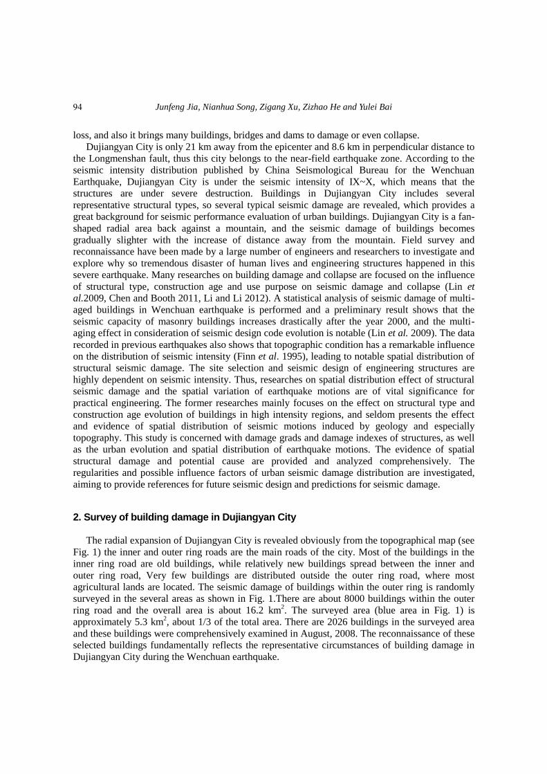
The radial expansion of Dujiangyan City is revealed obviously from the topographical map (see
Fig. 1) the inner and outer ring roads are the main roads of the city. Most of the buildings in the
inner ring road are old buildings, while relatively new buildings spread between the inner and
outer ring road, Very few buildings are distributed outside the outer ring road, where most
agricultural lands are located. The seismic damage of buildings within the outer ring is randomly
surveyed in the several areas as shown in Fig. 1.There are about 8000 buildings within the outer
ring road and the overall area is about 16.2 km2. The surveyed area (blue area in Fig. 1) is
approximately 5.3 km2, about 1/3 of the total area. There are 2026 buildings in the surveyed area
and these buildings were comprehensively examined in August, 2008. The reconnaissance of these
selected buildings fundamentally reflects the representative circumstances of building damage in
Dujiangyan City during the Wenchuan earthquake.
94
Structural damage distribution induced by Wenchuan Earthquake on 12th May, 2008
inner ring road
outer ring road
perfect slight medium severs collapse0.0
0.1
0.2
0.3
0.4
0.5
0.6
0.7
Dam
age
rati
o
Damage level
masonry
frame
bottom-frame
factory building
others
Fig. 1 Seismic reconnaissance region Fig. 2 Proportion of structural damage of buildings
Buildings in Dujiangyan City mainly consist of multistory masonry structures, multi-story
reinforced concrete structures, masonry structures with bottom RC frames, single-story industrial
plants and other old low dwellings. Among all these structures, the great majority of buildings are
multistory masonry structures, with the percentage of 53.2%. According to the classification of
function of buildings, these buildings are mainly for residential and commercial purpose,
government buildings, hospital, education buildings and factory, et al. It is found that 60% of the
surveyed buildings are used for residence, and almost all these buildings are multistory masonry
structures; about 15% of the surveyed buildings are for both commercial and residential purpose.
Most of these structures are multistory reinforced concrete structures, with the bottom frame
structures for commercial purpose and the upper part with multistory masonry structures for
residence. Almost all kinds of the buildings are damaged to variable levels according to the
National Evaluation Specification (PRCMC 1990). The damage level is classified into five levels:
almost in perfect condition, slight damage, moderate damage, severe damage and collapse. The
proportion of each type of structural damage is presented in Fig. 2. It can be seen that single-story
industrial plants, multistory masonry structures and buildings of other structural type are damaged
heavily in severe damage level and collapse level. The frame structures and bottom-frame
structures are relatively slightly damaged. It can be observed that the frame structure performs
better in earthquake than other structures.
The Post-earthquake field works part 3:Code for field survey(GB/T18208.3-2000)is
adopted in this study to present the comparison of damage level between different structures. The
formula in the specification provides the corresponding relationship of seismic damage grade and
damage index as follows
𝑑𝑖𝑗 = ∑𝑑𝑖𝑗𝑛𝑖𝑗/∑𝑛𝑖𝑗 (1)
Where 𝑑𝑖𝑗 is the damage index of buildings of structural type “i” with damage grade “j”; 𝑛𝑖𝑗 is the number of buildings of structural type “i” with damage degree “j”. The damage index
corresponding to each damage level adopts the median value of the given range in Appendix A1 of
the Post-earthquake field works part 3: Code for field survey (GB/T18208.3-2000) for ease of
calculation, which means that the five damage levels, respectively almost in perfect condition,
e
r
95
Junfeng Jia, Nianhua Song, Zigang Xu, Zizhao He and Yulei Bai
slight damage, moderate damage, severe damage and collapse, correspond to a damage index of
0.05, 0.2, 0.425, 0.70 and 0.925. Thus, the average damage index for masonry structures, frame
structures, masonry structures with bottom RC frames, industrial factory buildings and other
structures is 0.279, 0.176, 0.163, 0.410 and 0.315, respectively. It can be observed that the
industrial factory buildings are most severely damaged; the second is other structures including old
single-story dwellings and others collapsed structures whose structural type are unable to be
judged, thus the average damage index is relative large; while frame structures and masonry
structures with bottom RC frame are relatively slightly damaged.
3. Summarization of typical structural damage 3.1 Damage of multistory masonry structures
The multistory masonry structure is widely applied in Dujiangyan City for residential and
commercial buildings, especially, for those built before the year 2000. It is found from the
investigation that the main failure mode of multistory masonry structures includes damage of
bearing wall and non-bearing wall, destruction of constructional column and ring beam and
collapse or partial collapse of the structure.
Red bricks were used for most of the multistory masonry buildings built before 2000. Because
the earthquake action is largely inflicted on walls and the masonry walls are relatively weak in
shear strength, they are likely to reach shear failure. Failure of walls mainly appears as single
diagonal crack or X-shape crack. The survey of the Tangshan Earthquake in 1976 shows that
multistory masonry structures without constructional column and ring beam are most severely
damaged (Liu and Yang 1996). Since then, the seismic design code of China requires setting up
constructional column and ring beam to enhance seismic performance of buildings. However, lots
of masonry buildings investigated in Dujiangyan City have no constructional column or ring beam,
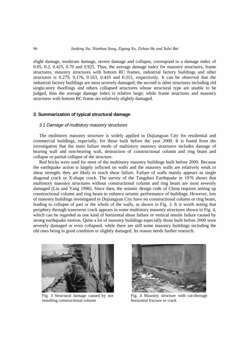
leading to collapse of part or the whole of the walls, as shown in Fig. 3. It is worth noting that
periphery through transverse crack appears in some multistory masonry structures shown in Fig. 4,
which can be regarded as one kind of horizontal shear failure or vertical tensile failure caused by
strong earthquake motion. Quite a lot of masonry buildings especially those built before 2000 were
severely damaged or even collapsed, while there are still some masonry buildings including the
old ones being in good condition or slightly damaged. Its reason needs further research.
Fig. 3 Structural damage caused by not
installing constructional column
Fig. 4 Masonry structure with cut-through
horizontal fracture or crack
96
Structural damage distribution induced by Wenchuan Earthquake on 12th May, 2008
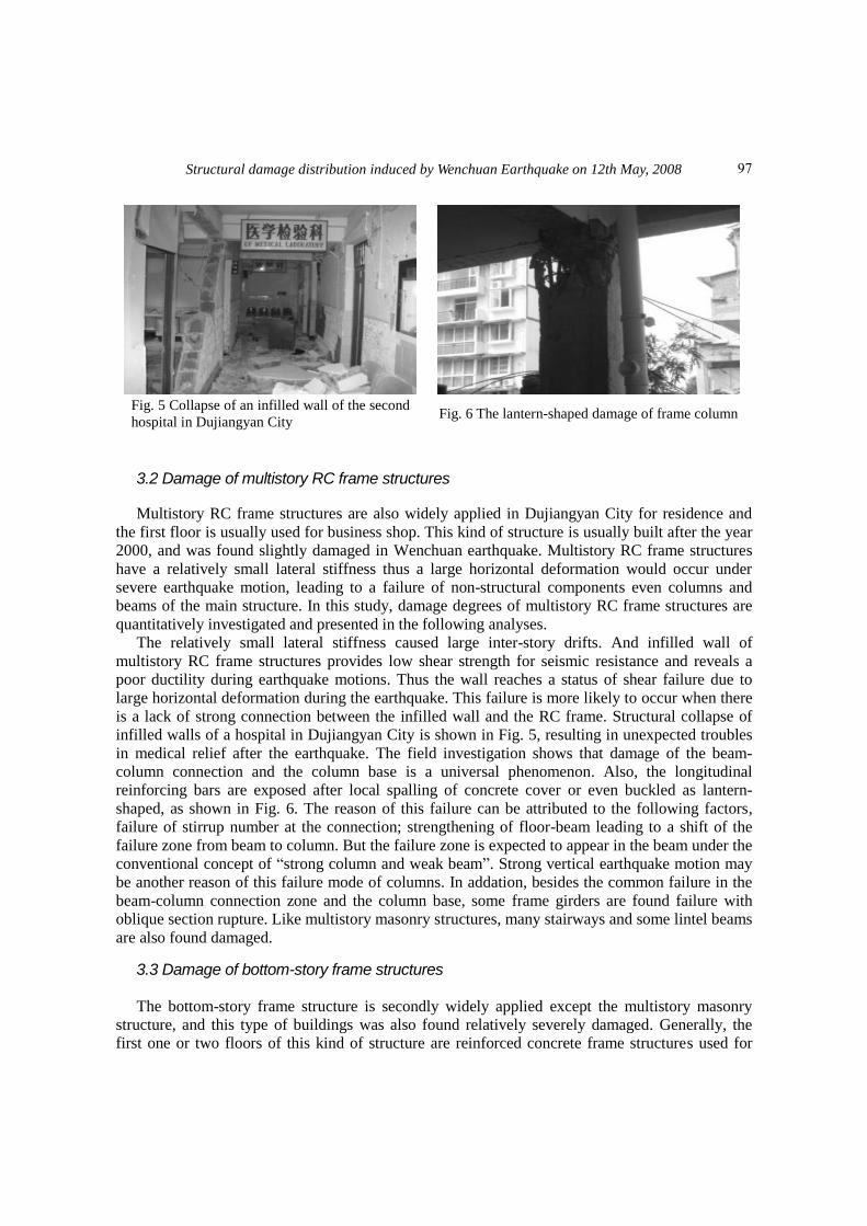
Fig. 5 Collapse of an infilled wall of the second
hospital in Dujiangyan City Fig. 6 The lantern-shaped damage of frame column
3.2 Damage of multistory RC frame structures
Multistory RC frame structures are also widely applied in Dujiangyan City for residence and
the first floor is usually used for business shop. This kind of structure is usually built after the year
2000, and was found slightly damaged in Wenchuan earthquake. Multistory RC frame structures
have a relatively small lateral stiffness thus a large horizontal deformation would occur under
severe earthquake motion, leading to a failure of non-structural components even columns and
beams of the main structure. In this study, damage degrees of multistory RC frame structures are
quantitatively investigated and presented in the following analyses.
The relatively small lateral stiffness caused large inter-story drifts. And infilled wall of
multistory RC frame structures provides low shear strength for seismic resistance and reveals a
poor ductility during earthquake motions. Thus the wall reaches a status of shear failure due to
large horizontal deformation during the earthquake. This failure is more likely to occur when there
is a lack of strong connection between the infilled wall and the RC frame. Structural collapse of
infilled walls of a hospital in Dujiangyan City is shown in Fig. 5, resulting in unexpected troubles
in medical relief after the earthquake. The field investigation shows that damage of the beam-
column connection and the column base is a universal phenomenon. Also, the longitudinal
reinforcing bars are exposed after local spalling of concrete cover or even buckled as lantern-
shaped, as shown in Fig. 6. The reason of this failure can be attributed to the following factors,
failure of stirrup number at the connection; strengthening of floor-beam leading to a shift of the
failure zone from beam to column. But the failure zone is expected to appear in the beam under the
conventional concept of “strong column and weak beam”. Strong vertical earthquake motion may
be another reason of this failure mode of columns. In addation, besides the common failure in the
beam-column connection zone and the column base, some frame girders are found failure with
oblique section rupture. Like multistory masonry structures, many stairways and some lintel beams
are also found damaged.
3.3 Damage of bottom-story frame structures The bottom-story frame structure is secondly widely applied except the multistory masonry
structure, and this type of buildings was also found relatively severely damaged. Generally, the
first one or two floors of this kind of structure are reinforced concrete frame structures used for
97
Junfeng Jia, Nianhua Song, Zigang Xu, Zizhao He and Yulei Bai
commerce; other floors are multistory masonry structures used for residence. Due to the small
lateral stiffness of the bottom frame, a weak story is likely to form. Under strong earthquake
motion, the bottom frame yields large horizontal deformation causing the exposure and buckling
of reinforcing steel in the frame column and the oblique section rupture of the frame girder.
Because of the infilled walls are usually made from brittle materials. The damage of infilled walls
is mainly caused by relatively large inter-story drifts. Shear cracks, including single diagonal
crack, X-shaped diagonal crack and crack at the beam-column connection are observed at the
bottom frame infilled wall. Failure of infilled walls directly threatens the safety of people and
apparatus, and may lead to great casualties and economic loss. Generally, infilled walls are more
severely damaged than the frame column, whose damage degree is severer than that of the frame
girder.
In the investigation, it is found that bottom-story of some buildings is a combination of half
frame structure and half masonry structure. The structural bottom floor facing the main road is
frame structure for commercial purpose while the other part of the hybrid bottom-story structure is
masonry structure for residential purpose or warehouse. Other than the bottom-story, the upper
part is the multistory masonry structure for residence. Under earthquake motion, without
constructional column or ring beam, the bottom masonry structure will generally be first damaged
and lose its bearing capacity due to its low shear strength. If there is further strong earthquake
motion, only the bottom frame structure is at work and the whole structure may be severely
damaged or even collapse. Thus this kind of structure should be abandoned in structural design or
at least adopt enough structural constructional measures to balance the load of the frame and
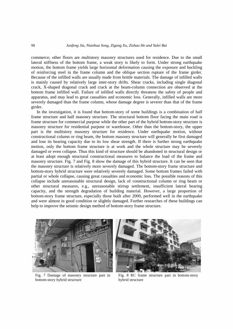
masonry structure. Fig. 7 and Fig. 8 show the damage of this hybrid structure. It can be seen that
the masonry structure is relatively more severely damaged. The bottom-story frame structure and
bottom-story hybrid structure were relatively severely damaged. Some bottom frames failed with
partial or whole collapse, causing great casualties and economic loss. The possible reasons of this
collapse include unreasonable structural design, lack of constructional column or ring beam or
other structural measures, e.g., unreasonable stirrup settlement, insufficient lateral bearing
capacity, and the strength degradation of building material. However, a large proportion of
bottom-story frame structure, especially those built after 2000, performed well in the earthquake
and were almost in good condition or slightly damaged. Further researches of these buildings can
help to improve the seismic design method of bottom-story frame structure.
Fig. 7 Damage of masonry structure part in
bottom-story hybrid structure
Fig. 8 RC frame structure part in bottom-story
hybrid structure
98
Structural damage distribution induced by Wenchuan Earthquake on 12th May, 2008
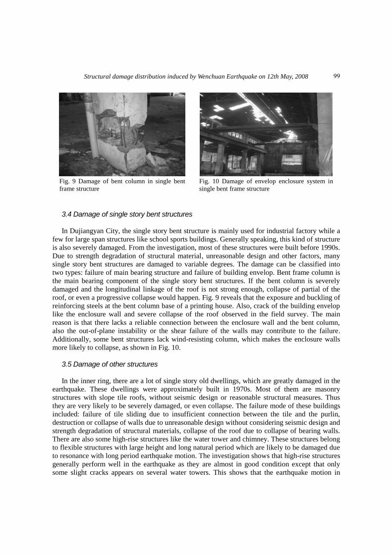
Fig. 9 Damage of bent column in single bent
frame structure
Fig. 10 Damage of envelop enclosure system in
single bent frame structure
3.4 Damage of single story bent structures
In Dujiangyan City, the single story bent structure is mainly used for industrial factory while a
few for large span structures like school sports buildings. Generally speaking, this kind of structure
is also severely damaged. From the investigation, most of these structures were built before 1990s.
Due to strength degradation of structural material, unreasonable design and other factors, many
single story bent structures are damaged to variable degrees. The damage can be classified into
two types: failure of main bearing structure and failure of building envelop. Bent frame column is
the main bearing component of the single story bent structures. If the bent column is severely
damaged and the longitudinal linkage of the roof is not strong enough, collapse of partial of the
roof, or even a progressive collapse would happen. Fig. 9 reveals that the exposure and buckling of
reinforcing steels at the bent column base of a printing house. Also, crack of the building envelop
like the enclosure wall and severe collapse of the roof observed in the field survey. The main
reason is that there lacks a reliable connection between the enclosure wall and the bent column,
also the out-of-plane instability or the shear failure of the walls may contribute to the failure.
Additionally, some bent structures lack wind-resisting column, which makes the enclosure walls
more likely to collapse, as shown in Fig. 10.
3.5 Damage of other structures In the inner ring, there are a lot of single story old dwellings, which are greatly damaged in the
earthquake. These dwellings were approximately built in 1970s. Most of them are masonry
structures with slope tile roofs, without seismic design or reasonable structural measures. Thus
they are very likely to be severely damaged, or even collapse. The failure mode of these buildings
included: failure of tile sliding due to insufficient connection between the tile and the purlin,
destruction or collapse of walls due to unreasonable design without considering seismic design and
strength degradation of structural materials, collapse of the roof due to collapse of bearing walls.
There are also some high-rise structures like the water tower and chimney. These structures belong
to flexible structures with large height and long natural period which are likely to be damaged due
to resonance with long period earthquake motion. The investigation shows that high-rise structures
generally perform well in the earthquake as they are almost in good condition except that only
some slight cracks appears on several water towers. This shows that the earthquake motion in
99
Junfeng Jia, Nianhua Song, Zigang Xu, Zizhao He and Yulei Bai
Dujiangyan City are mainly short-period, with little long-period component. However, this can be
resulted by energy dissipation through the waggle of water in the tower, reducing the seismic
damage.
4. Spatial distribution of building damage in Dujiangyan City
Dujiangyan City is fan-shaped and the First Ring Road divides this city into two parts: the inner
ring and the outer ring. The north-west part of the city is backed against the mountain and the
terrain in north-west part is high while the south-east part is relatively low. Distinctive spatial
distribution characteristics of seismic damage of buildings are observed from the earthquake
survey: structures in the inner ring are more severely damaged than those in the outer ring. The
further the structure away from the mountain, the more slightly it was damaged. To further
quantitatively investigate this spatial distribution pattern, the urban zone of the city is divided into
two parts: the inner ring backed against the mountain with a radius of about 5 km and the outer
ring farther away from the mountain with a radius of 9 km.
From the reconnaissance data of buildings in Dujiangyan city, the major structures in the city
are multistory masonry structures, which were severely damaged during the earthquake. In this
study, the spatial distribution pattern of multistory masonry is taken as an example to carry out the
quantitative and comparative investigation. The survey covers 1065 multistory masonry structures
which are evenly distributed in both rings: 392 in the inner ring and 673 in the outer ring. Fig. 11
shows the proportion of masonry structures built in inner and outer regions during different
construction periods, reflecting the evolution of urban building construction age at the same time.
It can be seen from the masonry buildings investigated that most of those in inner ring were built
in 1980s and 1990s and very few buildings were built after 2000, while those built in the outer ring
are gradually increasing in these stages.
According to seismic damage level of multistory masonry structures in inner ring and outer
ring, the damage index of buildings in inner ring is higher than that of buildings in the outer ring.
The average structural seismic damage index of inner ring is 0.395 while the index for the outer
ring is 0.212 in accordance with Eq. (1). The average damage index in inner ring is 1.86 times of
that in outer ring, reflecting that the buildings in inner ring region are more seriously damaged
than that in outer ring in Dujiangyan city.
As the structural seismic damage reveals a multi-aged characteristic, which means that
buildings built in different stages differ from others remarkably in anti-seismic capacity.
According to the evolution characteristic of the seismic design criterion of China, the building
structures are divided into four groups: before 1980s, 1980s, 1990s, after 2000. Buildings in the
same stage are regarded to have the same seismic capacity, thus the spatial distribution pattern can
be analyzed on the same seismic capacity level.
Figs. 12-15 show the seismic damage statistics of multistory masonry structures during these
four stages in the inner ring. It can be seen that no matter which stage the structures were built,
nearly all the structures in inner ring are more severely damaged than those in the outer ring,
especially for those buildings before the year of 2000, which revealed a strong spatial distribution
pattern. Structures built after 2000 were all slightly damaged no matter whether they are located in
the inner ring or the outer ring These figures also reveal that those structures built before 1980s are
most severely damaged while those built after 2000 are slightly damaged or in perfect condition.
However, it is noteworthy that those built in 1990s are relatively more severely damaged than
100

Structural damage distribution induced by Wenchuan Earthquake on 12th May, 2008
those built in 1980s. Further studies need to be carried out to dig the deep-seated reason for this
phenomenon.
pre 80' 80' 90' after 20000.0
0.1
0.2
0.3
0.4
0.5
Pro
po
tio
n o
f ea
chst
age
Construction age
inner ring
outer ring
Fig. 11 Proportion of masonry buildings in inner and outer region during each stage
perfect slight medium severs collapse0.0
0.1
0.2
0.3
0.4
0.5
0.6
0.7
0.8
0.9
1.0
Dam
age
rati
o
Damage level
inner ring
outer ring
perfect slight medium severs collapse0.0
0.1
0.2
0.3
0.4
0.5
0.6
0.7
0.8
0.9
1.0
Dam
age
rati
o
Damage level
inner ring
outer ring
Fig. 12 Damage ratios of masonry buildings
in Pre80s‟ Fig. 13 Damage ratios of masonry buildings in 1980s‟
perfect slight medium severs collapse0.0
0.1
0.2
0.3
0.4
0.5
0.6
0.7
0.8
0.9
1.0
Dam
age
rati
o
Damage level
inner ring
outer ring
perfect slight medium severs collapse0.0
0.1
0.2
0.3
0.4
0.5
0.6
0.7
0.8
0.9
1.0
Dam
age
rati
o
Damage level
inner ring
outer ring
Fig. 14 Damage ratios of masonry buildings
in1990s‟ Fig. 15 Damage ratios of masonry buildings after 2000
e
r
e
r
e
r
e
r
101
Junfeng Jia, Nianhua Song, Zigang Xu, Zizhao He and Yulei Bai
pre 80' 80' 90' after 20000.0
0.1
0.2
0.3
0.4
0.5
0.6
0.7
Av
erag
ed d
amag
e in
dex
Construction stage
inner ring
outer ring
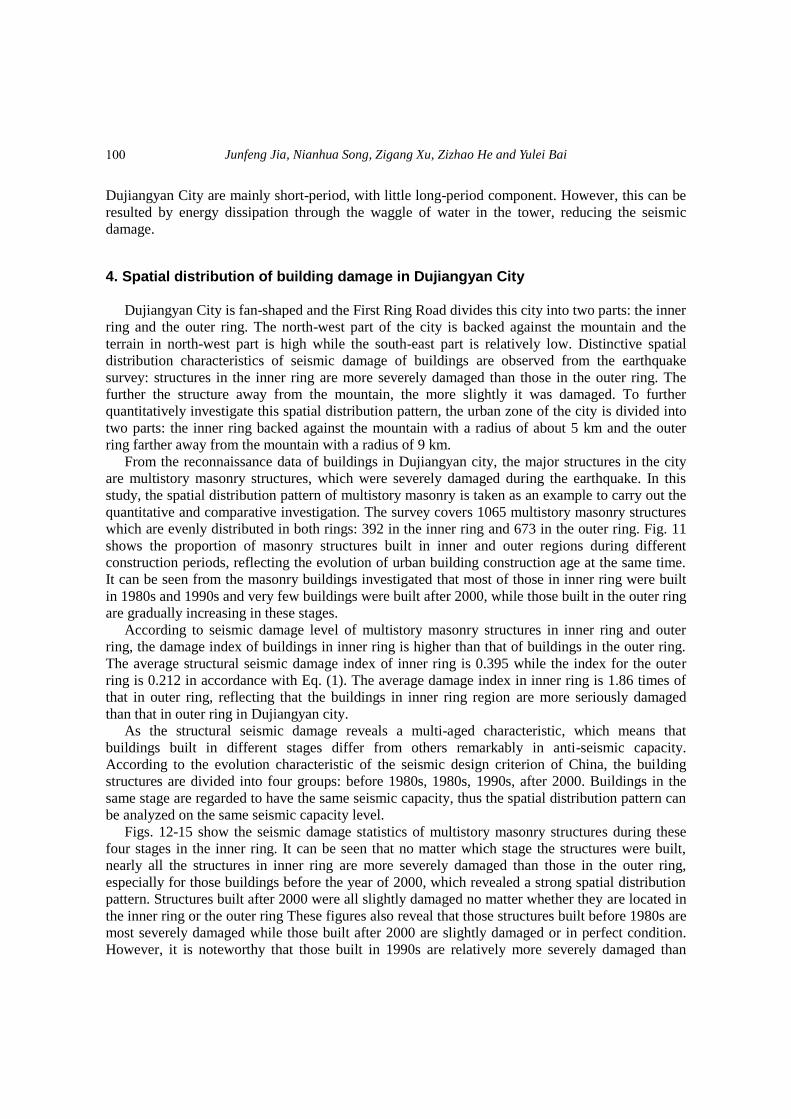
Fig. 16 Averaged damage index of masonry buildings of inner and outer ring part in each age
The seismic damage index of all the investigated multistory masonry structures calculated by
Eq. (1) is shown in Fig. 16. Nearly all the structural seismic damage in both rings become slighter
when the building age is relatively newer In the inner ring, the seismic damage index of structures
built before 1980s, in 1980s and in 1990s are 5.7, 3.6 and 3.4 times of that of structures built after
2000, while in the outer ring, the seismic damage index of the former three changes into 6.5, 2.6
and 3.4 times of structures built after 2000. Comparing the seismic damage index between the
inner ring and outer ring on the same seismic capacity level, the seismic damage index of
buildings built before 1980s in inner ring is 1.16 times, 1.88 times, 1.30 times and 1.34 times of
the indexes for structures in the corresponding construction stage in outer ring, respectively. Thus,
it can be observed that the further the structure is away from the mountain, the slighter it is
damaged, and the spatial distribution effect in virtue of terrain influence may be a vital factor of
seismic damage of buildings.
5. Analyses and discussions of spatial distribution effect of building damages
5.1 Influence of urban construction age evolution
With the evolution of the construction age of buildings, new buildings and old buildings are
distributed in different places in the city. Along with the update of the seismic design
specifications, newly built structures reveal a better seismic capacity than the early built structures.
Fig. 16 shows that the seismic damage index of old buildings can reach 6.5 times that of new
buildings. This distribution is the most important factor affecting the spatial distribution pattern of
the urban building damage (Lin et al. 2009). A study on severe damages and collapses of buildings
in moderate to severe earthquake intensities caused by the Wenchuan earthquake was carried out,
it is concluded that the seismic design of buildings strictly follows the Code for Seismic Design of
Buildings (GB50011-2001) of China, the quality construction and seismic capacity of buildings is
assured (Wang 2008). Three different levels of safety margin of buildings structures, referred as
fundamental safety margin, integrated safety margin and accidental safety margin, is proposed by
102
Structural damage distribution induced by Wenchuan Earthquake on 12th May, 2008
Ye et al. (Ye et al. 2008). They also put forward that lack of unexpected safety margin in current
seismic design code is the main reason of the severe building damage in the Wenchuan
earthquake, more researches on the integrated and accidental safety margin should be performed in
future structural design. Take the code for design of concrete structures in China as example, along
with evolution of the structural design code over the past more than 40 years, several major
changes and modification have been made through persistent theory research, experimental
verification and engineering practice in 5 generation of code in building material, structural detail,
design methodology, performance level (Xu 2010). Structural reliability and seismic performance
are remarkably enhanced following the evolution of structural design code in China (Jin et al.
2010).
5.2 Spatial difference of earthquake motions As is known to all, the spatial difference of earthquake motions may lead to a spatial
distribution of urban seismic damage. However, reasons for spatial difference of earthquake
motions are very complicated, including the effect of topography, geology, earthquake propagation
and even structural property of buildings and so on. And some research results reveal that the local
topographic or lithology may strongly affect ground motion in areas of highly variable topography
(Kaiser et al. 2013). The potential causation of spatial distribution of building damage in this city
is briefly analyzed herein.
5.2.1 Influence of topography According to the former research (Geli et al. 1988), topography is a significant factor
influencing the seismic damage of a certain area. For instance, the basin edge effect imposes more
severe damage to structures at the basin edge, which can be attributed to the reason that the shear
wave changes into surface wave when incident wave propagates to the highland at the basin edge.
At the same time, the incident seismic wave and the reflecting seismic wave reflected by highland
at basin edge might be superposed, leading to more serious structural damage. The field data
recorded during the 1971 San Fernando Earthquake (Oakeshott 1975), 1980 Fruili Earthquake
(Brambati et al. 1980), 1985 Chile Earthquake (Celebi and Hanks 1986) and the 1994 Northridge
Earthquake (Wennerberg et al.1994) authenticated the influence of topography on earthquake
motions. The seismic data recorded from Matsuzaki seismograph station (PWRI 1986) is also
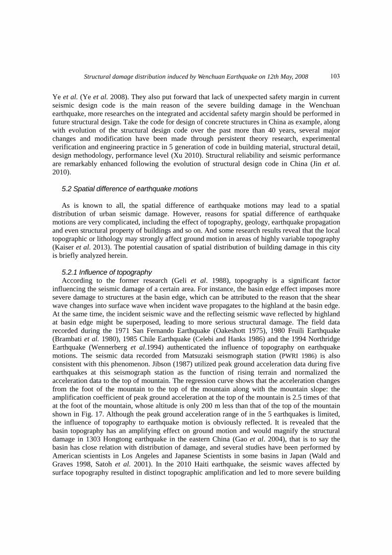
consistent with this phenomenon. Jibson (1987) utilized peak ground acceleration data during five
earthquakes at this seismograph station as the function of rising terrain and normalized the
acceleration data to the top of mountain. The regression curve shows that the acceleration changes
from the foot of the mountain to the top of the mountain along with the mountain slope: the
amplification coefficient of peak ground acceleration at the top of the mountain is 2.5 times of that
at the foot of the mountain, whose altitude is only 200 m less than that of the top of the mountain
shown in Fig. 17. Although the peak ground acceleration range of in the 5 earthquakes is limited,
the influence of topography to earthquake motion is obviously reflected. It is revealed that the
basin topography has an amplifying effect on ground motion and would magnify the structural
damage in 1303 Hongtong earthquake in the eastern China (Gao et al. 2004), that is to say the
basin has close relation with distribution of damage, and several studies have been performed by
American scientists in Los Angeles and Japanese Scientists in some basins in Japan (Wald and
Graves 1998, Satoh et al. 2001). In the 2010 Haiti earthquake, the seismic waves affected by
surface topography resulted in distinct topographic amplification and led to more severe building
103
Junfeng Jia, Nianhua Song, Zigang Xu, Zizhao He and Yulei Bai
damage on a prominent ridge top rather than at nearby soft soil sites (Hough et al. 2010). Gallipoli
et al. (2013) installed temporary accelerometer stations to study the role of site amplification in
building damage enhancement, and two of the monitored sites reveal an aggravation factor for
slopes and ridges, in which one reflects the spatial distribution of amplification as a function of the
site along a slope and the other proves validation of stratigraphic and topographic amplification
The geologic structure system of Dujiangyan City belongs to Cathaysoid tectonic system,
located through Longmenshan region of western Sichuan to the top of the Minjiang River Alluvial
Fan of Chengdu Plain. Its geomorphic unit belongs to the first bottom of the Minjiang River
Alluvial Fan. The north-west part of the city adjoins the Yulei Mountain making the terrain of
north-west high and the south-east low. Its downtown is fan-shaped and divided into two parts by
the First Ring Road, with a staircase distribution of high mountains, middle mountains, low
maintains, hills and plains. As the inner ring is near the mountain with high terrain, this could
likely be one of the causation that the structures in inner ring was more severely damaged than
those in outer ring, as shown in Fig. 16. In addition, the impact degree of this factor should be
further verified by the strong motion records from seismograph stations.
Due to lacking strong motion records from 2008 Wenchuan earthquake, a simulated main
shock in Dujiangyan district is synthesized by taking time-history of small earthquake as
Empirical Green‟s function (Li and Zhang 2011). The small earthquake is simulated by stochastic
method at the base of limited aftershock seismic records from ambulatory seismostations. It is
conclude that severe earthquake motion occurred during Wenchuan earthquake with approximate
peak ground acceleration (PGA) of 400 gal, and it also provide an evident that the PGA in
northwest district (the inner ring area in Fig. 1) is significantly larger than that in southeast district
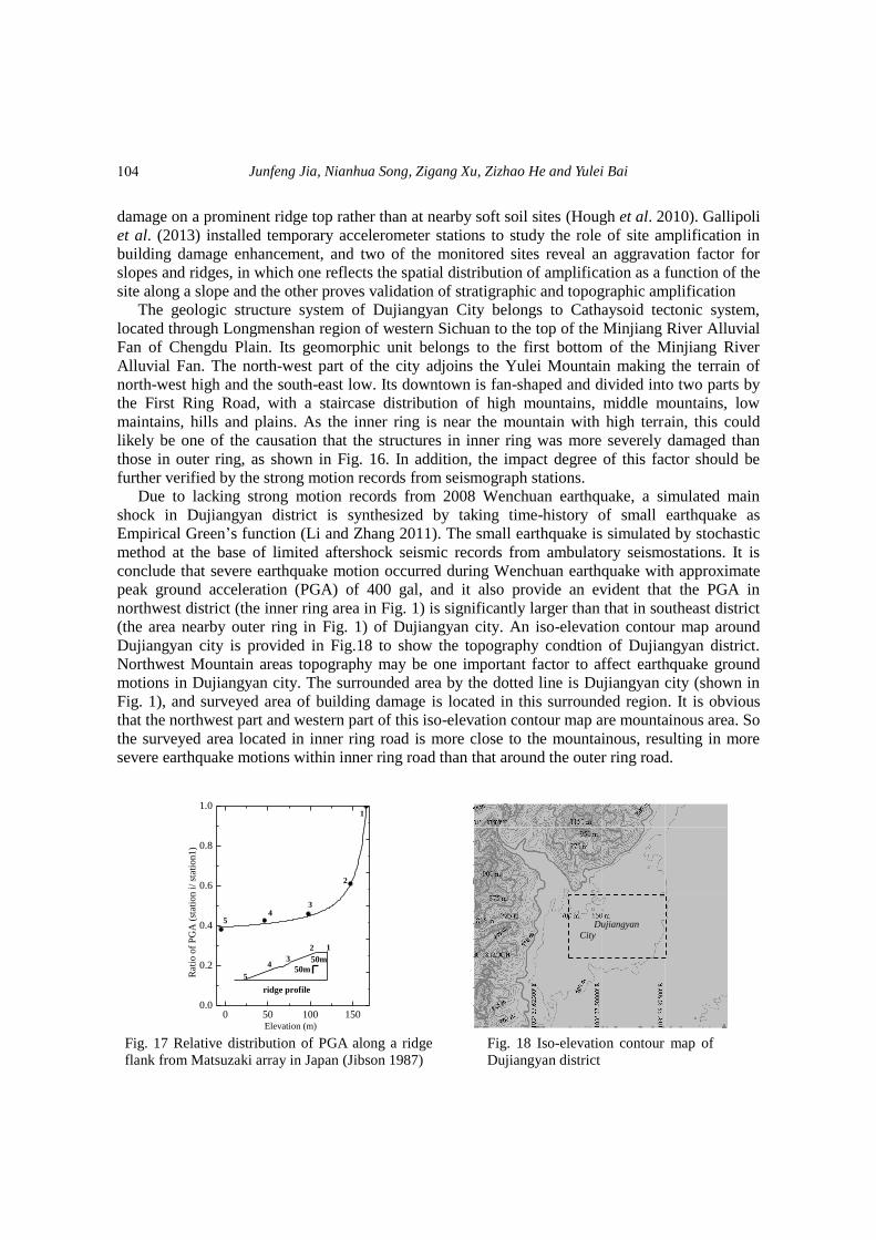
(the area nearby outer ring in Fig. 1) of Dujiangyan city. An iso-elevation contour map around
Dujiangyan city is provided in Fig.18 to show the topography condtion of Dujiangyan district.
Northwest Mountain areas topography may be one important factor to affect earthquake ground
motions in Dujiangyan city. The surrounded area by the dotted line is Dujiangyan city (shown in
Fig. 1), and surveyed area of building damage is located in this surrounded region. It is obvious
that the northwest part and western part of this iso-elevation contour map are mountainous area. So
the surveyed area located in inner ring road is more close to the mountainous, resulting in more
severe earthquake motions within inner ring road than that around the outer ring road.
0 50 100 1500.0
0.2
0.4
0.6
0.8
1.0
50m5
43
2 1
ridge profile
50m
54
3
2
Rat
io o
f P
GA
(st
atio
n i
/ st
atio
n1)
Elevation (m)
1
Fig. 17 Relative distribution of PGA along a ridge
flank from Matsuzaki array in Japan (Jibson 1987)
Fig. 18 Iso-elevation contour map of
Dujiangyan district
Dujiangyan
City
104
Structural damage distribution induced by Wenchuan Earthquake on 12th May, 2008
5.2.2 Influence of local site In earthquakes happened all over the world, more and more evidence have been found that the
prominent variance of seismic motions is related to local site condition. Three earthquakes have
occurred near Lorca town, located in Murcia province of Spain, in 1999 (Mula), 2002 (Bullas) and
2005 (La Paca) with magnitudes (Mw) of 4.7, 5.0 and 4.8, respectively, and the special relevance of
local site effects are contributed to the ground motion amplification cause by shallow geology and
the spatial distribution of building damage (Navarro et al. 2000, Benito et al. 2006, Navarro et al.
2007). During 2003 Colima (Mexico) earthquake, the ground motion amplifications revealed in
narrow high-frequency bands which may impose severe effects on the extent of building damage
and its spatial distribution, and clear spectral peaks had been found in a short period range in the
heavily damaged area, but these peaks did not appear at the slightly damaged area (Navarro et al.
2008). Similar phenomenon, that is of the prominent relevance to building damage distribution and
local site effects, was also verified in another two earthquakes occurred on May 11th, 2011 with
epicenter located near Lora Town of Spain (Navarro et al. 2012). In seismic design criteria of
China, the geological condition of Dujiangyan City is the second type site. However, different
distance to the mountain may have different geological condition and site condition. Generally
speaking, places near the mountain are bedrock site, and the mountain which the city backs against
is made of rock resulted from tectonics. Thus site condition in the inner ring is likely to be harder
than that in the outer ring. The seismic damage of high-rise structures in the city is relatively
slighter, meaning that the long seismic periodic component is relatively less than the short seismic
periodic component. Thus the seismic motion intensity in the inner ring with harder condition
might be larger than that in the outer ring. This might be one of the important factors leading to the
spatial distribution of seismic damage. If the geological prospecting and site condition data can be
acquired, the influence degree of this factor can be further investigated.
5.2.3 Influence of directivity effects during fault rupture In near-fault regions, long-period pulse-like ground motions with high amplitude and short
duration will be caused by forward directivity during fault rupture, and the direction of pulse-like
motions is always perpendicular to the fault surface. Extensive researches on the characterization
of pulse-like ground motion and its influence on engineering structures resulted from rupture
direction effects have been performed in recent decade (Yahyai et al. 2011, Casey and Liel 2012).
Some research results have shown that pulse-like ground motions have important roles in the
distribution of damages over the structural height. Most of rupture direction effect are accumulated
in lower 1/3 of 1/2 of structural height and the growing rate of ductility demand at lower parts of
buildings height in near fault regions is two times higher than that in far-filed regions (Gerami and
Abdollahzadeh 2014). Previous researches have demonstrated that the prominent influence of
pulse-like ground motions on structural seismic behavior in near-fault regions, and further
investigation on the formation mechanism and implication in anti-seismic design of engineering
structures are in progress. The Wenchuan Earthquake caused by the Wenchuan-Yingxiu fault
rupture of Longmenshan Fault Zone belongs to near-field earthquake and Dujiangyan is only 21
kilometers from the epicenter. Existing researches show that when fault ruptures, the near fault
seismic ground motions might have some distinctive characteristics such as the forward directivity
effect and hanging wall effect (Abrahamson and Somerville 1996, Mavroeidis and Papageorgiou
2002, Vladimir and Douglas 2004, Xie et al. 2012). As the seismogenic fault of the Wenchuan
Earthquake is located at the north-west of the city, the structures in inner ring is more close to the
epicenter and rupture fault. Thus the propagation of fault rupturing and the influence of near-fault
105
Junfeng Jia, Nianhua Song, Zigang Xu, Zizhao He and Yulei Bai
ground motion effects may be another important factor influencing the spatial distribution of
seismic damage.
6. Conclusions
In this investigation, statistical analyses of the seismic damage investigation of structures in
Dujiangyan City are presented. Taking the multistory masonry structures for instance, there are
two main factors influencing the spatial distribution of building damage, the urban building
construction age evolution and the spatial difference of earthquake motion, and comprehensive
investigation and potential reasons for the influences are discussed.
The evolution of construction age is the most primary factor influencing the spatial distribution
of structural seismic damage. The average damage level of old buildings constructed by former
design codes with insufficient seismic bearing capacity is more severe than that of new buildings
constructed by current codes. In China, as a result of evolution of structural design criterions,
massive dwelling buildings and factory plants are constructed in different ages, revealing multi-
aging effect. The strength increase of building material, adoption of reliability design
methodology, more rationality of structure system of modern design code in China greatly
improve the seismic resistant capacity of modern engineering structures. It is recommended that
the performance evaluation and structural retrofitting should be performed on existing buildings
constructed by obsolete design guidelines to strengthen structural safety.
The spatial distribution of earthquake motions may be another important factor influencing the
spatial distribution of building damage. Comparing the seismic damage of buildings during each
construction age, the average seismic damage index of buildings in inner ring is evidently larger
than that in outer ring with maximum amplification coefficient of 1.89. It is the evidence that the
spatial distribution of earthquake ground motions induced distinguished structural damage in
different area away from the mountain. But in current seismic design code of China and many
other countries, effects of spatial distribution in a certain city especially near a mountain is seldom
considered in structural design of buildings, which should be attracted more attentions in the future
structural design.
The causation of the spatial difference of earthquake motions is substantially complicated,
including the topography, geology, site condition and propagation of seismic wave generated by
rupture fault and other factors. The specific causation needs further studies and analyses according
to the geological diversities and strong earthquake observation records. A valuable evidence of
multi-aging effect of buildings and spatial distribution of earthquake motions are potential reasons
for severe structural damage of buildings. Amplification effect of earthquake motions near fault
rupture and mountain topography may be very prominent factor to affect earthquake ground
motions. Relevant evidence is provided by seismic inversion method, seismic survey of building
damage and topography of Dujiangyan district. So it is necessary that the amplification effect
should be considered in seismic design of structures located in complicated topography and near
active faults. Site selection of new-built buildings and engineering structures should be considered
the spatial distribution of earthquake ground motions. Not only non-uniform excitation of ground
motions be further investigated in engineering structural design, topography effect, directivity
effect of fault rupture and local site effect also should be involved in seismic analysis, design and
reinforcement, especially for engineering structures in mountainous area and near potential active
earthquake fault.
106
Structural damage distribution induced by Wenchuan Earthquake on 12th May, 2008
Acknowledgements
This research is jointly funded by the National Natural Science Fund of China (Grants No.51208015, No.51378033), Specialized Research Fund for the Doctoral Program of Higher Education of China (Grant No. 20121103120022) and the research project of Beijing Municipal Commission of Education (Grant KZ201410005011). Their supports are gratefully acknowledged.
References
Abrahamson, N.A. and Somerville, P.G. (1996), “Effects of the hanging wall and footwall on ground
motions recorded during the Northridge earthquake”, Bull. Seismol. Soc. Am., 86(1B), 93-99. Benito, B., Capote, R., Murphy, P., Gaspar-Escribano, J.M., Martínez-Díaz, J.J., Tsige, M. and Canora, C.
(2007), “An overview of the damaging and low magnitude Mw 4.8 La Paca earthquake on 29 January
2005: context, seismotectonics, and seismic risk implications for Southeast Spain”, Bull. Seismol. Soc.
Am., 97(3), 671-690.
Brambati, E., Faccioli, E., Carulli, E., Culchi, F., Onofri, R., Stefanini, R. and Uloigrai, F. (1980), “Studio de
Microzonizzacione Sismica Dell‟are do Tarento (Fruili)”, Edito da Regione Autonoma Fruili-Venezia,
Giulia.
Casey, C. and Liel, A. (2012), “The effect of near-fault directivity on building seismic collapse risk”,
Earthq. Eng. Struct. Dyn., 41(10), 1391-1409.
Celebi, M. and Hanks, T. (1986), “Unique site response conditions of two major earthquakes of 1985: Chile
and Mexico”, International Symposium of Engineering Geology Problems in Seismic Areas, Bari, Italy.
Chen, Y. and Booth, D.C. (2011), The Wenchuan Earthquake of 2008-anatomy of a disaster, Beijing:
Science Press.
Finn, W.D.L., Ventura, C.E. and Schuster, N.D. (1995), “Ground motions during the 1994 Northridge
earthquake”, Can. J. Civ. Eng., 22(2), 300-315.
Gallipoli, M.R., Bianca, M., Mucciarelli, M., Parolai, S. and Picozzi, M. (2013), “Topographic versus
stratigraphic amplication: mismatch between code provisions and observations during the L‟Aquila (Italy
2009) sequence”, Bull. Earthq. Eng., 11(5), 1325-1336.
Gao, M.T., Jin, X.S., An, W.P. and Lv, X.J. (2004), “The GIS and analysis of earthquake damage
distribution of the 1303 Hongtong M=8 earthquake”, Acta Seismologica Sinica, 17(4), 398-404.
GB/T18208.3-2000, Poet-earthquake field works-part3: Code for field survey, Standards Press of China,
Beijing, China. (in Chinese)
Geli, L., Bard, P.Y. and Jullien, B. (1988), “The effect of topography on earthquake ground motion: a
review and new results”, Bull. Seismol. Soc. Am., 78(1), 42-63.
Gerami, M. and Abdollahzadeh, D. (2014), “Vulnerability of steel moment-resisting frames under effects of
forward directivity”, Struct. Des. Tall Spec. Build., 24(2), 97-122.
Hough, S.E., Altidor, J.R., Anglade, D., Given, D., Janvier, M.G., Maharrey, J.Z., Meremonte, M., Mildor,
B.S., Prepetit, C. and Yong, A. (2010), “Localized damage caused by topographic amplification during the
2010 M7.0 Haiti earthquake”, Nat. Geosci., 3(11), 778-782.
Jibson, R. (1987), “Summary of research on the effects of topographic amplification of earthquake shaking
on slope stability”, U.S. Geological Survey, Open-File Report, 87-268.
Jin, W.L., Yue, Z.G. and Gao, L.Y. (2010), “State-of-the-art development on „Code for design of masonry
structures”, 31(6), 22-28. (in Chinese)
Kaiser, A., Holden, C. and Massey, C. (2013), “Determination of site amplification, polarization and
topographic effects in the seismic response of the Port Hills following the 2011 Christchurch earthquake”,
New Zealand Society for Earthquake Engineering Annual Conference, GNS Science, Avalon, Lower
107
Junfeng Jia, Nianhua Song, Zigang Xu, Zizhao He and Yulei Bai
Hutt., New Zealand.
Li, M. and Li, X.J. (2012), “Analysis of some building damage phenomena in the Wenchuan earthquake”,
Earthq. Res. China, 26(2), 243-251.
Li, Q.C. and Zhang, J.M. (2011), “Ground motion simulations of Dujiangyan district in Wenchuan
earthquake”, J. Heilongjiang Inst. Sci. Technol., 21(3), 180-184.
Lin, C., Hou, S. and Ou, J.P. (2009), “Seismic damage characteristics of multi-aged buildings in Dujiangyan
city subjected to Wenchuan earthquake”, J. Dalian Univ. Technol., 49(5), 748-753.
Liu, D.H. and Yang, C.R. (1996), “Multistory buildings in concentrated reinforced masonry”, Eleventh
World Conference on Earthquake Engineering, Acoplus, Mexico.
Mavroeidis, G.P. and Papageorgiou, A.S. (2002), “Near-source strong ground motion: characteristics and
design issues”, Proceedings of the Seventh U.S. National Conference on Earthquake Engineering
(7NCEE), Boston: the Earthquake Engineering Research Institute, 21-25.
Navarro, M., Sánchez, F.J., Enomoto, T. and Rubio, S. (2000), “Relation between the predominant period of
soil and the damage distribution after Mula 1999 earthquake”, Sixth International Conference on Seismic
Zonation (6ICSC), November 12-15, 2000, Palm Spring, California, USA.
Navarro, M., Vidal, F. and Enomoto, T. (2007), “Analysis of site effects weightiness on RC building seismic
response: The Adra town example (SE Spain)”, Earthq. Eng. Struct. Dyn., 36(10), 1363-1383.
Navarro, M., Enomoto, T., Yamamoto, T., García-Jerez, A., Vidal, F. and Bretón, M. (2008), “Analysis of site
effects and their correlation with damage distribution observed during the Colima (Mexico) earthquake of
January 21, 2003”, In Proceeding 14th world Conference on Earthquake Engineering, Beijing.
Navarro, M., García-Jerez, J.A., Alcalá, F.J., Vidal, F., Aranda, C. and Enomoto, T. (2012), “Analysis of site
effects, building response and damage distribution observed due to the 2011 Lorca, Spain, Earthquake”, In
15th World Conference of Earthquake Engineering 15WCEE.
Oakeshott, G.B. (1975), “San Fernando, California, Earthquake of 9 February 1971”, California Division of
Mines and Geology, Sacramento, California, USA.
PRCMC (1990), “Lever-classification standard of earthquake damage to buildings”, No. 377, Beijing,
China. (in Chinese)
PWRI (1986), “Dense instrument array observation of strong earthquake motion”, Ministry of Construction,
Tsukuba, Japan.
Satoh, T., Kawase, H., Sato, T. and Pitarka, A. (2001), “Three-dimensional finite-difference waveform
modeling of strong motions observed in the Sendai basin, Japan”, Bull. Seismol. Soc. Am., 91(4), 812-825.
Vladimir, G. and Douglas, D. (2004), “Seismological implications of the ground motion data from the 2003
San Simeon earthquake”, Proceedings of SMIP04 Seminar on Utilization of Strong-Motion Data, Moh
Huang, Sacramento, The California Geological Survey, 25-40.
Wald, D.J. and Graves, R.W. (1998), “The seismic response of the Los Angeles basin, Calfornia”, Bull.
Seismol. Soc. Am., 88(2), 337-356.
Wang, Y.Y. (2008), “Lessons learnt from building damages in the Wenchuan earthquake-seismic concept
design of buildings”, J. Build. Struct., 29(4), 20-25.
Wennerberg, L., Borcherdt, R.D., Meuller, C., Dietel, C., Sembera, E., Westerlund, R. and Hough, S.
(1994), “Aftershock observations suggestive of large, linear site amplification at the Cedar Hill Nursery
Accelerograph Station, Tarzana, California”, Program Abstracts of the 89th
Annual Meeting on
Seismological Society of America, Pasadena, California.
Xie, J.J., Wen, Z.P., Li, X.J., Li, Y.Q., Lu, H.S. and Huang, J.Y. (2012), “Analysis of velocity pulses for near-
fault strong motions from the Wenchuan earthquake based on wavelet method”, Diqiu Wuli Xuebao,
55(6), 1963-1972. (in Chinese)
Xu, Y.L. (2010), “Development of concrete structure theory and code”, J. Build. Struct., 31(6), 17-21. (in
Chinese)
Yahyai, M., Rezayibana, B. and Mohammadrezapour, E. (2011), “Effect of near-fault earthquakes with
108

Structural damage distribution induced by Wenchuan Earthquake on 12th May, 2008
forward directivity on telecommunication towers”, Earthq. Eng. Eng. Vib., 10(2), 211-218.
Ye, L.P., Lu, X.Z., Qu, Z. and Feng, P. (2008), “Analysis on building seismic damage in the Wenchuan
Earthquake”, Proceedings of the 14th
World Conference on Earthquake Engineering, Beijing, China.
CC
109


![CO6-1 Characterization of Clustered DNA Damage Induced by ......tered DNA damage is a unique radiation damage [1], and estimate quantity and quality of clustered DNA damage induced](https://img.pdfslide.net/doc/110x75/5fe67e48b2da127c1835f903/co6-1-characterization-of-clustered-dna-damage-induced-by-tered-dna-damage.jpg)