Embed Size (px)
Citation preview

Study on Tourism Planning and Management Information System Based on Component
GIS Technology
Haifeng LI Institute of Engineering Surveying Sichuan College of Architectural Technology, Deyang, China
Email: [email protected]
Abstract: In view of the flourish of tourism, the author takes tourism planning and management information system in Mianyang City as an example and puts forward how to make GIS technology applied to planning and management of tourism resources. The article focuses on database design, function modules design as well as the relevant technical processes for system. At last, it achieves organic integration with spatial analysis of tourism information, inquiries and other professional applications, and basic geographic information.
Keywords: GIS; planning and management; spatial database design; function design
1 Introduction
With the rapid development of economy, tourism has been emerging gradually in china, which can provide food, housing, transportation, travel, purchase, range of services and other entertainment for tourists. Services provided by the tourism industry are built on a variety of tourist information collection, arrangement and transmission. Economic benefits and social benefits of tourism will be greatly improved, if we introduce the modern advanced technology, means and methods in planning and management travel information. The tourism information system is based on database system, covering the major elements of the tourism industry, including many sub-systems in early time. At present, there are many successful examples in European countries, such as the well-known Austria Tyrol information system, Switzerland Rhodes information system and etc [1]. But, at present, a number of traveling information system is mainly for tourists which just includes information query, retrieval [2], therefore, the function is too narrow. In order to enhance the application level of GIS technology in the tourism field, promote the development of tourism and provide support in decision making for the government, we must do the further research. So, we decide to apply component GIS technology and develop tourism planning and management information system.
2 Designing Principles of System [3, 4]
1) Operability. The interface of system is friendly, the function operation of system is simple and intuitive, visualization degree is high, different levels of user can use it freely, system should be simple, flexible and easy to promote.
2) Expansibility and open. In designing stage, we must take into account the system's expansion and compatibility with other systems, so we leave room for encoding travel information, selecting coordinate system of base map in designing database and system functions as far as possible, in order to expand system or transfer bank, the existing modules and the structure of the system will not be affected, when we increase new modules.
3) Security. The system is stable and will not lost data because of misuse or damage by person, the important data should be backup automatic.
4) Economy. Economy is one of the major issues we must consider in building system, with the minimal input for the maximum output. On the basis of achieving all functions of the system we ought to think about how to save the cost such as in hardware and software configuration, system development and database design.
5) Uniformity and standardization. In order to ensure the system’s scientific character, practicability and integration with domestic and international information of database, we should follow unified and standard in coding information, choosing coordinate system, controlling data accuracy and building symbol system in system designing stage.
3 Choosing Development Tools for System
There are multiple types of data involved in this system: vector graphics, raster graphics, graphics with CAD style, photo with JPG style, multimedia data, so we require a powerful database to manage all this data files. We integrate a wide range of comparison and select SQL Server2000 as the background database in this issues, it also has the ability to transform with other formats of data. In development tools aspect: we choose VB+MapX pattern and C/S structure in developing software for this system. Combination of GIS tool and visualization development
*Granted by bureau of Sichuan Environmental Protection (NO. 2008HBY002)
165 978-1-935068-10-5 © 2010 SciRes.
Proceedings of Annual Conference of China Institute of Communications
language for the secondary development is the mainstream of GIS application development. Because it not only can take full advantage of GIS tools for spatial database management and analysis functions, but also can use other languages' advantages, such as efficient and convenient programming, if we set the strengths of the two, the efficiency of application system development can be greatly increased, the system will have better appearance and more powerful database function, it is also easy to transplant, maintain and with higher reliability.
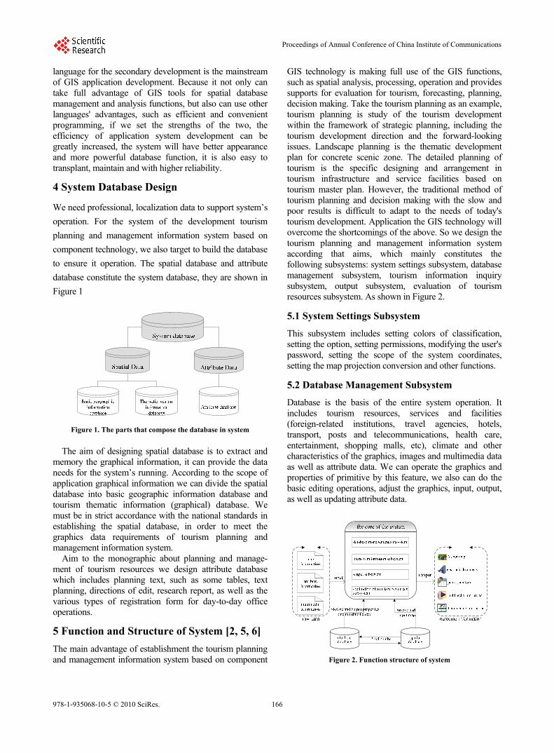
4 System Database Design
We need professional, localization data to support system’s
operation. For the system of the development tourism
planning and management information system based on
component technology, we also target to build the database
to ensure it operation. The spatial database and attribute
database constitute the system database, they are shown in
Figure 1
Figure 1. The parts that compose the database in system
The aim of designing spatial database is to extract and
memory the graphical information, it can provide the data needs for the system’s running. According to the scope of application graphical information we can divide the spatial database into basic geographic information database and tourism thematic information (graphical) database. We must be in strict accordance with the national standards in establishing the spatial database, in order to meet the graphics data requirements of tourism planning and management information system.
Aim to the monographic about planning and manage- ment of tourism resources we design attribute database which includes planning text, such as some tables, text planning, directions of edit, research report, as well as the various types of registration form for day-to-day office operations.
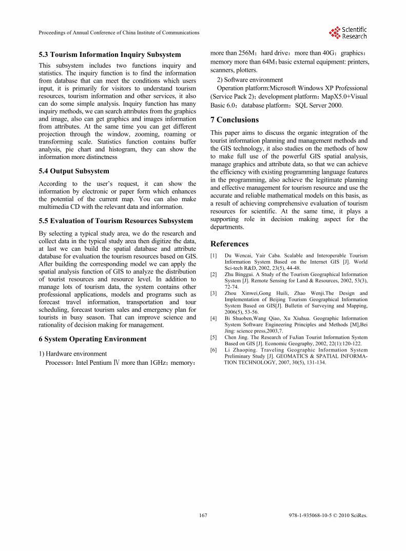
5 Function and Structure of System [2, 5, 6]
The main advantage of establishment the tourism planning and management information system based on component
GIS technology is making full use of the GIS functions, such as spatial analysis, processing, operation and provides supports for evaluation for tourism, forecasting, planning, decision making. Take the tourism planning as an example, tourism planning is study of the tourism development within the framework of strategic planning, including the tourism development direction and the forward-looking issues. Landscape planning is the thematic development plan for concrete scenic zone. The detailed planning of tourism is the specific designing and arrangement in tourism infrastructure and service facilities based on tourism master plan. However, the traditional method of tourism planning and decision making with the slow and poor results is difficult to adapt to the needs of today's tourism development. Application the GIS technology will overcome the shortcomings of the above. So we design the tourism planning and management information system according that aims, which mainly constitutes the following subsystems: system settings subsystem, database management subsystem, tourism information inquiry subsystem, output subsystem, evaluation of tourism resources subsystem. As shown in Figure 2.
5.1 System Settings Subsystem
This subsystem includes setting colors of classification, setting the option, setting permissions, modifying the user's password, setting the scope of the system coordinates, setting the map projection conversion and other functions.
5.2 Database Management Subsystem
Database is the basis of the entire system operation. It includes tourism resources, services and facilities (foreign-related institutions, travel agencies, hotels, transport, posts and telecommunications, health care, entertainment, shopping malls, etc), climate and other characteristics of the graphics, images and multimedia data as well as attribute data. We can operate the graphics and properties of primitive by this feature, we also can do the basic editing operations, adjust the graphics, input, output, as well as updating attribute data.
Figure 2. Function structure of system
166978-1-935068-10-5 © 2010 SciRes.
Proceedings of Annual Conference of China Institute of Communications
5.3 Tourism Information Inquiry Subsystem
This subsystem includes two functions inquiry and statistics. The inquiry function is to find the information from database that can meet the conditions which users input, it is primarily for visitors to understand tourism resources, tourism information and other services, it also can do some simple analysis. Inquiry function has many inquiry methods, we can search attributes from the graphics and image, also can get graphics and images information from attributes. At the same time you can get different projection through the window, zooming, roaming or transforming scale. Statistics function contains buffer analysis, pie chart and histogram, they can show the information more distinctness
5.4 Output Subsystem
According to the user’s request, it can show the information by electronic or paper form which enhances the potential of the current map. You can also make multimedia CD with the relevant data and information.
5.5 Evaluation of Tourism Resources Subsystem
By selecting a typical study area, we do the research and collect data in the typical study area then digitize the data, at last we can build the spatial database and attribute database for evaluation the tourism resources based on GIS. After building the corresponding model we can apply the spatial analysis function of GIS to analyze the distribution of tourist resources and resource level. In addition to manage lots of tourism data, the system contains other professional applications, models and programs such as forecast travel information, transportation and tour scheduling, forecast tourism sales and emergency plan for tourists in busy season. That can improve science and rationality of decision making for management.
6 System Operating Environment
1) Hardware environment Processor:Intel Pentium more than 1GHzⅣ ;memory:
more than 256M;hard drive:more than 40G;graphics:memory more than 64M;basic external equipment: printers, scanners, plotters.
2) Software environment Operation platform:Microsoft Windows XP Professional
(Service Pack 2);development platform:MapX5.0+Visual Basic 6.0;database platform:SQL Server 2000.
7 Conclusions
This paper aims to discuss the organic integration of the tourist information planning and management methods and the GIS technology, it also studies on the methods of how to make full use of the powerful GIS spatial analysis, manage graphics and attribute data, so that we can achieve the efficiency with existing programming language features in the programming, also achieve the legitimate planning and effective management for tourism resource and use the accurate and reliable mathematical models on this basis, as a result of achieving comprehensive evaluation of tourism resources for scientific. At the same time, it plays a supporting role in decision making aspect for the departments.
References [1] Du Wencai, Yair Caba. Scalable and Interoperable Tourism
Information System Based on the Internet GIS [J]. World Sci-tech R&D, 2002, 23(5), 44-48.
[2] Zhu Binggui. A Study of the Tourism Geographical Information System [J]. Remote Sensing for Land & Resources, 2002, 53(3), 72-74.
[3] Zhou Xinwei,Gong Huili, Zhao Wenji.The Design and Implementation of Beijing Tourism Geographical Information System Based on GIS[J]. Bulletin of Surveying and Mapping, 2006(5), 53-56.
[4] Bi Shuoben,Wang Qiao, Xu Xiuhua. Geographic Information System Software Engineering Principles and Methods [M],Bei Jing: science press,2003,7.
[5] Chen Jing. The Research of FuJian Tourist Information System Based on GIS [J]. Economic Geography, 2002, 22(1):120-122.
[6] Li Zhaoping. Traveling Geographic Information System Preliminary Study [J]. GEOMATICS & SPATIAL INFORMA- TION TECHNOLOGY, 2007, 30(5), 131-134.
167 978-1-935068-10-5 © 2010 SciRes.
Proceedings of Annual Conference of China Institute of Communications