Embed Size (px)
Citation preview

6 April 2018
SUCCESSFUL COMMENCEMENT OF DRILLING PROGRAM AT MANIRY GRAPHITE PROJECT MADAGASCAR
• Successful commencement of diamond drilling program at the high-priority
Razafy Prospect – part of the broader Maniry Project
• Total planned program at Razafy of 53 holes for 3,612 metres
• BEM currently drilled 1,074 metres and completed 15 holes at Razafy
• Positive core recovery and predictable graphitic mineralisation leads to
increased drill spacing
• First assay results scheduled for mid-May 2018
BlackEarth Minerals NL (ASX: BEM) (the Company or BlackEarth) is pleased to advise an update to its diamond drilling program at the Company’s 100% owned Maniry Graphite Project, Madagascar. The drilling is being completed by respected local drilling contractor, Orezone Drilling Madagascar SARL (Orezone). A photograph of core recovered is shown at Figure 1.
Figure 1 - Drill Core from Razafy Prospect
From commencement of drilling on 2 March 2018 to 31 March 2018, a total of 1,074 metres has been drilled and a total of 15 holes has been completed. See Figure 2 below which outlines location of completed drill holes as well as proposed holes yet to be drilled. The Company has focused its initial diamond drilling within the Maniry Graphite Project on the high priority Razafy Prospect. This will be followed up with infill drilling at the Haja Prospect which lies approximately 2km south of Razafy. Both of these prospects fall within the large exploration lease PR39751.
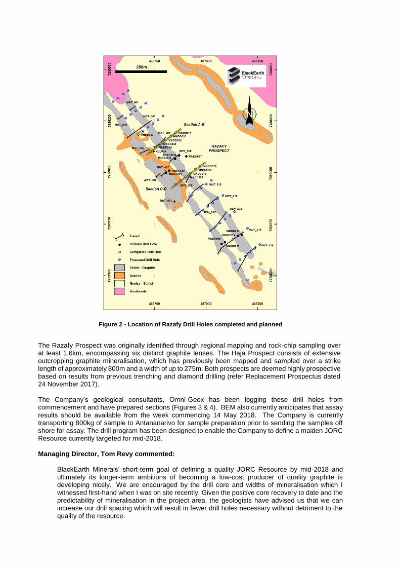
Figure 2 - Location of Razafy Drill Holes completed and planned
The Razafy Prospect was originally identified through regional mapping and rock-chip sampling over at least 1.6km, encompassing six distinct graphite lenses. The Haja Prospect consists of extensive outcropping graphite mineralisation, which has previously been mapped and sampled over a strike length of approximately 800m and a width of up to 275m. Both prospects are deemed highly prospective based on results from previous trenching and diamond drilling (refer Replacement Prospectus dated 24 November 2017). The Company’s geological consultants, Omni-Geox has been logging these drill holes from commencement and have prepared sections (Figures 3 & 4). BEM also currently anticipates that assay results should be available from the week commencing 14 May 2018. The Company is currently transporting 800kg of sample to Antananarivo for sample preparation prior to sending the samples off shore for assay. The drill program has been designed to enable the Company to define a maiden JORC Resource currently targeted for mid-2018. Managing Director, Tom Revy commented:
BlackEarth Minerals’ short-term goal of defining a quality JORC Resource by mid-2018 and ultimately its longer-term ambitions of becoming a low-cost producer of quality graphite is developing nicely. We are encouraged by the drill core and widths of mineralisation which I witnessed first-hand when I was on site recently. Given the positive core recovery to date and the predictability of mineralisation in the project area, the geologists have advised us that we can increase our drill spacing which will result in fewer drill holes necessary without detriment to the quality of the resource.

Figure 3 - Razafy Drill logs Section A-B looking NW
Figure 4 Razafy drill logs Section C-D looking NW
MEDIA CONTACTS Tom Revy, BlackEarth Minerals NL 08 6145 0289 | 0411 475 376
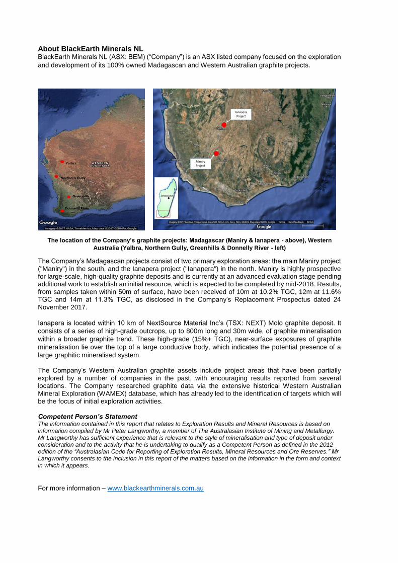
About BlackEarth Minerals NL BlackEarth Minerals NL (ASX: BEM) (“Company”) is an ASX listed company focused on the exploration
and development of its 100% owned Madagascan and Western Australian graphite projects.
The location of the Company’s graphite projects: Madagascar (Maniry & Ianapera - above), Western
Australia (Yalbra, Northern Gully, Greenhills & Donnelly River - left)
The Company’s Madagascan projects consist of two primary exploration areas: the main Maniry project ("Maniry") in the south, and the Ianapera project ("Ianapera") in the north. Maniry is highly prospective for large-scale, high-quality graphite deposits and is currently at an advanced evaluation stage pending additional work to establish an initial resource, which is expected to be completed by mid-2018. Results, from samples taken within 50m of surface, have been received of 10m at 10.2% TGC, 12m at 11.6% TGC and 14m at 11.3% TGC, as disclosed in the Company’s Replacement Prospectus dated 24 November 2017.
Ianapera is located within 10 km of NextSource Material Inc’s (TSX: NEXT) Molo graphite deposit. It
consists of a series of high-grade outcrops, up to 800m long and 30m wide, of graphite mineralisation
within a broader graphite trend. These high-grade (15%+ TGC), near-surface exposures of graphite
mineralisation lie over the top of a large conductive body, which indicates the potential presence of a
large graphitic mineralised system.
The Company’s Western Australian graphite assets include project areas that have been partially explored by a number of companies in the past, with encouraging results reported from several locations. The Company researched graphite data via the extensive historical Western Australian Mineral Exploration (WAMEX) database, which has already led to the identification of targets which will be the focus of initial exploration activities. Competent Person’s Statement The information contained in this report that relates to Exploration Results and Mineral Resources is based on information compiled by Mr Peter Langworthy, a member of The Australasian Institute of Mining and Metallurgy. Mr Langworthy has sufficient experience that is relevant to the style of mineralisation and type of deposit under consideration and to the activity that he is undertaking to qualify as a Competent Person as defined in the 2012 edition of the “Australasian Code for Reporting of Exploration Results, Mineral Resources and Ore Reserves.” Mr Langworthy consents to the inclusion in this report of the matters based on the information in the form and context in which it appears. For more information – www.blackearthminerals.com.au

Appendix 1 – Table outlining drilling status of Razafy drill holes
Hole_ID Status Easting Northing RL Azi Dip Pl_Depth Current Depth EOH_Depth
MNDD018 Complete 486972 7286033 297 233 -60 100 - 104.12
MNDD018A Complete 486972 7286033 297 211 -60 100 13.72
MNDD019 Complete 486924 7285997.27 297 233 -60 35 - 49.06
MNDD020 Complete 486948 7286015.32 297 233 -60 75 - 77.25
MNDD021 Complete 486851.55 7286193.11 297 233 -60 100 - 99.86
MNDD022 Complete 486803.63 7286157 296 233 -60 45 - 42.84
MNDD023 Complete 486828 7286175 297 233 -60 75 - 75.56
MNDD024 Complete 486900 7285979 294 233 -60 100 - 103.93
MNDD025 Complete 486732 7286103 293 233 -60 35 - 41.51
MNDD026 Complete 486756 7286121 293 233 -60 70 - 74.64
MNDD027 Complete 486672 7286183 292 233 -60 35 - 43.72
MNDD028 Complete 486780 7286139 296 233 -60 105 - 104.83
MNDD029 Complete 486696 7286201 295 233 -60 70 - 76.72
MNDD030 Complete 486876 7285961 291 233 -60 75 - 74.08
MNDD031 Complete 486743 7286237 299 233 -60 45 - 49.97
MNDD032 Current 486767 7286255 297 233 -60 75 25.72
MNDD033 Current 486852 7285943 293 233 -60 40 16.27
Planned 486611 7286263 295 233 -60 35
Planned 486635 7286281 295 233 -60 70
Planned 486659 7286299 297 233 -60 105
Planned 486683 7286317 297 233 -60 45
Planned 486707 7286335 297 233 -60 75
Planned 486551 7286342 297 233 -60 35
Planned 486575 7286360 297 233 -60 70
Planned 486599 7286379 297 233 -60 30
Planned 486623 7286397 297 233 -60 45
Planned 486930 7285889 291 233 -60 75
Planned 486978 7285925 295 233 -60 25
Planned 487002 7285943 297 233 -60 65
Planned 487026 7285962 297 233 -60 90
Planned 486960 7285799 289 233 -60 40
Planned 486984 7285817 292 233 -60 75
Planned 487008 7285835 293 233 -60 100
Planned 487032 7285854 296 233 -60 35
Planned 487056 7285872 298 233 -60 75
Planned 487080 7285890 297 233 -60 100
Planned 487021 7285719 286 233 -60 40
Planned 487045 7285738 289 233 -60 70
Planned 487069 7285756 291 233 -60 100
Planned 487093 7285774 294 233 -60 35
Planned 487116 7285792 297 233 -60 75
Planned 487140 7285810 297 233 -60 100
Planned 487141 7285560 285 233 -60 40
Planned 487165 7285578 287 233 -60 75
Planned 487189 7285596 288 233 -60 100

Planned 487213 7285614 291 233 -60 35
Planned 487237 7285632 293 233 -60 70
Planned 487261 7285650 297 233 -60 100
Planned 487201 7285480 297 233 -60 40
Planned 486719 7286219 297 233 -60 105
Planned 486791 7286273 297 233 -60 100
Planned 487129 7285676 290 233 -60 100
Planned 487201 7285730 297 233 -60 100
Totals 3655 1,032
JORC Code, 2012 Edition – Table 1
report template Section 1 Sampling Techniques and Data (Criteria in this section apply to all succeeding sections.)
Criteria JORC Code explanation Commentary
Sampling techniques
· Nature and quality of sampling (eg cut channels, random chips, or specific specialised industry standard measurement tools appropriate to the minerals under investigation, such as down hole gamma sondes, or handheld XRF instruments, etc). These examples should not be taken as limiting the broad meaning of sampling.
Diamond drilling program - Sampling will consist of 2m composite samples of quarter core. Samples will be cut using a diamond blade core saw. Duplicate samples will be collected every 20th sample for QAQC purposes. Sampling is considered to be comprehensive and representative. Remaining core was retained as a permeant reference. Assaying technique is still to be determined.
· Include reference to measures taken to ensure sample representivity and the appropriate calibration of any measurement tools or systems used.
· Aspects of the determination of mineralisation that are Material to the Public Report.
· In cases where ‘industry standard’ work has been done this would be relatively simple (eg ‘reverse circulation drilling was used to obtain 1 m samples from which 3 kg was pulverised to produce a 30 g charge for fire assay’). In other cases more explanation may be required, such as where there is coarse gold that has inherent sampling problems. Unusual commodities or mineralisation types (eg submarine nodules) may warrant disclosure of detailed information.
Drilling techniques
· Drill type (eg core, reverse circulation, open-hole hammer, rotary air blast, auger, Bangka, sonic, etc) and details (eg core diameter, triple or standard tube, depth of diamond tails, face-sampling bit or other type, whether core is oriented and if so, by what method, etc).
Diamond drilling. Core size is HQ and NQ typically in 0.5-1.5m runs. Core from a select number of holes will be orientated.
Drill sample recovery
· Method of recording and assessing core and chip sample recoveries and results assessed.
Core recovery is routinely recorded every metre by a trained geologist.
· Measures taken to maximise sample recovery and ensure representative nature of the samples.
· Whether a relationship exists between sample recovery and grade and whether sample bias may have occurred due to preferential loss/gain of fine/coarse material.
Logging
· Whether core and chip samples have been geologically and geotechnically logged to a level of detail to support appropriate Mineral Resource estimation, mining studies and metallurgical studies.
All holes are logged by a qualified and experienced geologist. All logging included descriptions of

· Whether logging is qualitative or quantitative in nature. Core (or costean, channel, etc) photography.
geotechnical, mineralisation, structural and lithological aspects of the core and was digitally recorded using an industry standard code system. Core is formally photographed. Data collected offers sufficient detail for the purpose of interpretation and further studies.
· The total length and percentage of the relevant intersections logged.
Sub-sampling techniques and sample preparation
· If core, whether cut or sawn and whether quarter, half or all core taken. Quarter core will be cut
using a diamond core saw and collected for assay. 2 metre composite sampling are deemed to be comprehensive and representative for the style/type of mineralisation under investigation. Duplicate samples are taken (remaining quarter core) every 20th sample for QAQC purposes
· If non-core, whether riffled, tube sampled, rotary split, etc and whether sampled wet or dry.
· For all sample types, the nature, quality and appropriateness of the sample preparation technique.
· Quality control procedures adopted for all sub-sampling stages to maximise representivity of samples.
· Measures taken to ensure that the sampling is representative of the in situ material collected, including for instance results for field duplicate/second-half sampling.
· Whether sample sizes are appropriate to the grain size of the material being sampled.
Quality of assay data and laboratory tests
· The nature, quality and appropriateness of the assaying and laboratory procedures used and whether the technique is considered partial or total.
Assaying details are still to be confirmed at this point, these will be detailed once assay results are received.
· For geophysical tools, spectrometers, handheld XRF instruments, etc, the parameters used in determining the analysis including instrument make and model, reading times, calibrations factors applied and their derivation, etc.
· Nature of quality control procedures adopted (eg standards, blanks, duplicates, external laboratory checks) and whether acceptable levels of accuracy (ie lack of bias) and precision have been established.
Verification of sampling and assaying
· The verification of significant intersections by either independent or alternative company personnel.
No holes are twinned at this stage. Data is digitally stored off site.
· The use of twinned holes.
· Documentation of primary data, data entry procedures, data verification, data storage (physical and electronic) protocols.
· Discuss any adjustment to assay data.
Location of data points
· Accuracy and quality of surveys used to locate drill holes (collar and down-hole surveys), trenches, mine workings and other locations used in Mineral Resource estimation.
All XYZ surveying was collected using a handheld Garmin GPS accurate to ±4m. Projection and Grid system used: UTM (WGS84) Z38S. At the end of the program holes will be recorded using a DGPS (accurate to 10cm)
· Specification of the grid system used.
· Quality and adequacy of topographic control.
· Data spacing for reporting of Exploration Results. NA
Data spacing and distribution
· Whether the data spacing and distribution is sufficient to establish the degree of geological and grade continuity appropriate for the Mineral Resource and Ore Reserve estimation procedure(s) and classifications applied.
· Whether sample compositing has been applied.
Orientation of data in relation to geological structure
· Whether the orientation of sampling achieves unbiased sampling of possible structures and the extent to which this is known, considering the deposit type.
The orientation of the drilling is not expected to introduce sampling bias. Most drill holes have intersected the mineralisation at near perpendicular angles to strike.
· If the relationship between the drilling orientation and the orientation of key mineralised structures is considered to have introduced a sampling bias, this should be assessed and reported if material.
Sample security · The measures taken to ensure sample security.
Samples are cut and sampled on site before being transported to the company sample preparation facility in Antananarivo for preparation. Samples will then be freighted by DHL to the awarded laboratory for assay. It is reasoned that the samples will be under sufficient security.
Audits or reviews · The results of any audits or reviews of sampling techniques and data.
NA
Section 2 Reporting of Exploration Results (Criteria listed in the preceding section also apply to this section.)
Criteria JORC Code explanation Commentary
Mineral tenement and land tenure status
· Type, reference name/number, location and ownership including agreements or material issues with third parties such as joint ventures, partnerships, overriding royalties, native title interests, historical sites, wilderness or national park and environmental settings.
Work was undertaken upon permits 5394 & 3432 • The tenements are located within the inland South West of Madagascar approximately centred on the townships of Fotradrevo and Ampanihy. • Tenements are held 100% by Mada Aust Ltd. A wholly owned subsidiary of Black Earth Minerals Ltd. • No overriding royalties are in place • There is no native title agreement required • Tenure does not coincide with any historical sites or national parkland • Semi-arid, thinly vegetated, relatively flat to low lying hills with sub-cropping rock. • Tenements are currently secure and in good standing.
· The security of the tenure held at the time of reporting along with any known impediments to obtaining a licence to operate in the area.

Exploration done by other parties
· Acknowledgment and appraisal of exploration by other parties.
Regional mapping by BRGM, Historical diamond drilling and trenching by Malagasy Minerals Ltd. (2014-2016)
Geology · Deposit type, geological setting and style of mineralisation.
The project overlies a prominent 20km wide zone consisting of a folded assemblage of graphite and quartz-feldspar schists (<60% graphite), quartzite and marble units, with lesser intercalated amphibolite and leucogneiss. This zone, termed the Ampanihy Belt is a core component of the Neoproterozoic Graphite System. The belt is interpreted as a ductile shear zone accreted from rocks of volcanic and sedimentary origins.
Drill hole Information
· A summary of all information material to the understanding of the exploration results including a tabulation of the following information for all Material drill holes:
Refer to table within text
o easting and northing of the drill hole collar
o elevation or RL (Reduced Level – elevation above sea level in metres) of the drill hole collar
o dip and azimuth of the hole
o down hole length and interception depth
o hole length.
· If the exclusion of this information is justified on the basis that the information is not Material and this exclusion does not detract from the understanding of the report, the Competent Person should clearly explain why this is the case.
Data aggregation methods
· In reporting Exploration Results, weighting averaging techniques, maximum and/or minimum grade truncations (eg cutting of high grades) and cut-off grades are usually Material and should be stated.
NA
· Where aggregate intercepts incorporate short lengths of high grade results and longer lengths of low grade results, the procedure used for such aggregation should be stated and some typical examples of such aggregations should be shown in detail.
· The assumptions used for any reporting of metal equivalent values should be clearly stated.
Relationship between mineralisation widths and intercept lengths
· These relationships are particularly important in the reporting of Exploration Results.
NA
· If the geometry of the mineralisation with respect to the drill hole angle is known, its nature should be reported.
· If it is not known and only the down hole lengths are reported, there should be a clear statement to this effect (eg ‘down hole length, true width not known’).

Diagrams
· Appropriate maps and sections (with scales) and tabulations of intercepts should be included for any significant discovery being reported These should include, but not be limited to a plan view of drill hole collar locations and appropriate sectional views.
Refer to figures within text
Balanced reporting
· Where comprehensive reporting of all Exploration Results is not practicable, representative reporting of both low and high grades and/or widths should be practiced to avoid misleading reporting of Exploration Results.
NA
Other substantive exploration data
· Other exploration data, if meaningful and material, should be reported including (but not limited to): geological observations; geophysical survey results; geochemical survey results; bulk samples – size and method of treatment; metallurgical test results; bulk density, groundwater, geotechnical and rock characteristics; potential deleterious or contaminating substances.
Refer to BEM Prospectus.
Further work
· The nature and scale of planned further work (eg tests for lateral extensions or depth extensions or large-scale step-out drilling).
All assay results to be received.
· Diagrams clearly highlighting the areas of possible extensions, including the main geological interpretations and future drilling areas, provided this information is not commercially sensitive.

![PETROLEUM (DRILLING AND PRODUCTION) REGULATIONS · PETROLEUM (DRILLING AND PRODUCTION) REGULATIONS [L.N. 69 of 1969.] under section 9 [27th November, 1969] [Commencement.] PART I](https://img.pdfslide.net/doc/110x75/5e946cef8e279368830b2d70/petroleum-drilling-and-production-regulations-petroleum-drilling-and-production.jpg)