Embed Size (px)
Citation preview

SUMER AND THE SEA
Deltas, Shoreline and Urban Water Management in 3rd Millennium BC Mesopotamia

1
In the frame of the International Association for Archaeological Research in Western &
Central Asia (ARWA), Licia Romano (Dept “Institute of Oriental Studies”, Sapienza
University of Rome), with the collaboration of Franco D’Agostino (Dept “Institute of
Oriental Studies”, Sapienza University of Rome), Holly Pittman and Reed Goodman
(University of Pennsylvania), Marc Lebeau (European Centre for Upper Mesopotamian
Studies), Cameron Petrie (University of Cambridge), and Liviu Giosan (Woods Hole
Oceanographic Institution, Woods Hole, MA) proposes an International Workshop «Sumer
and the Sea ». The goal of the workshop is to take stock of the present research on
Sumerian society and its relationship with water and the sea, focusing on the recent
archaeological and geo-archaeological research in Southern Mesopotamia.
“Sumer and the Sea” is under the auspices of ARWA, of recent creation and based in
Brussels. ARWA brings together nearly 500 scholars and students, specializing in various
fields related to archaeology, from 47 different countries (www.arwa-international.org).
ARWA members are joined together by the common intent to establish a worldwide link
between scholars, acting together in order to defend the archaeological discipline and its
scientists through several services (informing, encouraging joint projects, mentoring
promising students, advising international organizations). Among its different activities,
ARWA will organize fourteen international research workshops within the time frame of 4
years, corresponding to the term of office of its administrators. These workshops bring
together around thirty specialists and are aimed at the joint analysis of a specific topic,
promoting international research cooperation.
“Sumer and the Sea” will be held online from the 2nd to the 4th of June 2021.
* * * * * * * * * *
The Mesopotamian culture flourished on the banks of the Tigris and Euphrates Rivers, in a
landscape that was impacted by several changes during the last 6000 years following the
last post-glacial rise and stabilization of the sea-level. The ancient shoreline was located
about 250-260 km inland from the present coastline and was formed by Tigris and Euphrates
deltas. Inhabiting an area located near the 30th parallel north, inside the semi-arid zone,
the development of Sumerian society was strongly influenced by the exploitation of the
fluvial systems, the sea, and the peculiar marsh environment created by them.
On the one hand, the natural occurrence of crevasse splays was surely at the basis of the
first form of controlled irrigation and agriculture, while on the other, sea, rivers and
channels were perfect trade routes through which Sumer was afforded access to a wide
spectrum of resources. Nonetheless, 3rd mill. BC Southern Mesopotamian population had
to cope with a fragile environment, strongly affected by complex natural processes,
including floods, sea-level fluctuations and climatic changes occurring during the
Holocene.
The Workshop “Sumer and the Sea: Deltas, Shoreline, and Urban Water Management in
3rd
Millennium Mesopotamia” will focus on the interaction between Sumerians and their
2
water-dominated environment. The new data, obtained through remote sensing and
through geological coring, will allow us to discuss the evolution of the ancient shoreline,
whose progradation during the centuries profoundly modified the landscape and affected
the life of Southern Mesopotamian settlements. The presentation of the recent
archaeological and geo-archaeological research in Southern Iraq, together with the coeval
cuneiform sources, will enrich our historical perspectives on the way in which Sumerians
adapted to the marshy environment, using and managing water outside and inside the
cities. A special session of the workshop will be devoted to the presentation and analysis
of the different research strategies and methods which are now currently being used. This
will lead to a concluding discussion of the shared practical issues and challenges
encountered by archaeo-geological work in Iraq.
with the collaboration of:

SUMER AND THE SEA
Deltas, Shoreline and Urban Water Management in 3rd Millennium BC Mesopotamia
PROGRAMME
June 2nd
10:00-10:30 Institutional greetings
10:30-11:00 Dr Laith Majeed Hussein, President of the State Board of Antiquities and
Heritage, Introductory speech
11:00-11:30 Coffee Break
Chair: Franco D’Agostino
11:30-12:00 Max Engel, Helmut Brueckner - Holocene Climate Variability in the Near East
and its Impact on the History of Civilisation
12:00-12:30 Stacy Carolin - Timing of Regional Drying and Changes in Frequency and/or
Strength of Shamal Dust Events Throughout the 3rd
Mill. BC
12:30-13:00 Badir Albadran - The Effect of Tectonics on the Surface Features and River
Courses Changes
1300-14:30 Lunch Time
Chair: Reed Goodman
14:30-15:00 Joerg Fassbinder - Archaeological Geophysics: Magnetic Traces in the Marshy
Environment of Southern Mesopotamia
15:00-15:30 Reed Goodman, Liviu Giosan - The Tigris-Euphrates Deltaic Complex and its
Relation to the Lagash Floodplain
15:30-16:00 Jennifer R. Pournelle - Islands in the Storm. Turtlebacks, Tells, and Marshland
Cities
16:00-16:30 Coffee Break
Chair: Holly Pittman
16:30-17:00 Galina S Morozova - Avulsion Styles, Channel Networks, Flooding, and
Bronze Age Settlement Patterns in Lower Mesopotamia
17:00-17:30 Stephanie Rost -Managing the Ancient Tigris in the late 3rd and Early 2nd
Millennium BC

1
June 3rd
Chair: Liviu Giosan
11:30-12:00 Taher Al-Hosseini - Archaeological Activities in Iraq and Legislative Frame
12:00-12:30 Arsalan Othman - Determination of the Ancient Shoreline and
Anthropogenic Sites Using Remote Sensing Techniques
12:30-14:30 Lunch Time
Chair: Marco Ramazzotti
14:30-15:00 Susanne Rutishauser, Sebastien Borkowski - The «Rivers of Mesopotamia»
Research Project
15:00-15:30 Jafar Jotheri - Changing River Courses and Their Relationship to Settlement
15:30-16:00 Coffee Break
Chair: Maria Giovanna Biga
16:00-16:30 Jan Walstra - Reconstructing the Palaeo-Environment of the Ancient City of
Charax Spasinou
16:30-17:00 Lorenzo Verderame - From the Marshes to the Sea: The Waterscape of
Ancient Sumer
17:00-17:30 Abdulamir al Hamdani - Ethno-Archaeological Models of Waterscape and
Landscape in the Marshes of Southern Iraq
June 4th
Chair: Cameron Petrie
9:30-10:00 Philippe Quenet - Eridu and the Sea: A Long-Standing Issue
10:00-10:30 Adelheid Otto, Berthold Einwag and Jörg Fassbinder - Waterways at
Shuruppak and Ur. New Ideas from Old Sites
10:30-11:00 Ella Egberts - Reconstructing the Waterscapes of Tells in Southern
Mesopotamia: Remote Sensing and Geoarchaeological Survey Results from
Girsu
11:00-11:30 Coffee Break
Chair: Lorenzo Nigro
11:30-12:00 Licia Romano, Luca Forti, Franco D'Agostino, Salvatore Milli - Drilling is not
Boring: Geoarchaeological Research at Abu Tbeirah
12:00-12:30 Stuart Campbell - Tell Khaiber and the Sealands

2
12:30-13:00 Chris Morhange, Alexandra Bivolaru, Daniela Cottica, David Kaniewski, Nick
Marriner, Hadeer Sheisha, Gamal Younes - Geoarchaeology of Fluvial
Harbors. Case Studies: Isonzo Delta (Aquileia, Italy), Danube Delta
(Noviodunum, Halmyris, Orgamé, Romania) and the Nile (Giza, Egypt).
13:00-14:30 Lunch Time
14:30-14:40 Eduardo Garzanti – Short communication - Sedimentary Mineralogy as a Tool
in Geoarchaeological Research
14:40-15:30 Final discussion

3
ABSTRACT
Dr Laith Majeed Hussein, President of the State Board of Antiquities and Heritage
INTRODUCTORY SPEECH
The State Board of Antiquities and Heritage (SBAH) has as its mission to protect the
archaeological heritage of Iraq. In order to accomplish this, heritage monuments should
undergo continual review in order to maintain world heritage protection standards. SBAH
is also responsible for overseeing the relationships with the foreign exploratory
expeditions of the Mesopotamian civilization. SBAH consists of seven general directorates
through which it manages the archaeological affairs of Iraq. In order that foreign
expeditions can achieve effective relations and communication while working in Iraq, this
speech will describe the nature and functions of each of these departments. SBAH
recognizes that modern archaeological fieldwork has incorporated new methods and
scientific techniques that may require the export of samples for analysis. SBAH is
committed to support such methods and techniques, and will strive to facilitate these
studies in accordance with the rules and regulations of Iraq.
Badir Albadran - Almaaqal University [email protected]
THE EFFECT OF TECTONICS ON THE SURFACE FEATURES AND RIVER COURSES CHANGES
The southern part of the Mesopotamian Plain is under the influence of the collision of the
two tectonic plates represented by the Arabian Plate and the Iranian Plate, in addition to
what it causes from the compression of the ancient and deep layers of salt to uplift as salt
domes, leaving its impact on the surface features in the region. Some of the salt domes
appeared on the surface in the region, represented by Jabal Sanam in the far southwest of
the city of Basra. Tectonics left their mark on ancient river courses, which forced some
rivers to change their paths and turn to other paths, where the ground level is lower than
that. The best example in this study is the course of the Shatt al-Arab River and the
meanders they suffered in its course within the Basra region. One of these meanders is in
the north and two are in the south of the city of Basra. Certainly, changing river courses
due to tectonics calls for humans in the past to follow those streams and consequently to
the continuous movement and change in population agglomerations, and this is what we
see now in the pattern of distribution of ancient cities in the region.
Stuart Campbell – Manchester University; [email protected]
TELL KHAIBER AND THE SEALANDS
The excavated occupation at Tell Khaiber primarily dates to the First Sealand Dynasty, when
it was the location of a large-scale, fortified building that had local administrative functions
in the mid-16th century BCE. However, its connections to the sea itself are perhaps less

4
obvious, not least because of the arid, inland landscape that now surrounds it. Nonetheless,
Tell Khaiber does sit within a wider set of connections that situate it as much in the marine
region of the northern end of the Gulf as in the southern end of southern Mesopotamia.
There is also surprising evidence from the site of links across the Indian Ocean that
suggests access to a much wider network of maritime interactions.
Stacy Carolin -Department of Earth Sciences - University of Cambridge; [email protected]
TIMING OF REGIONAL DRYING AND CHANGES IN FREQUENCY AND/OR STRENGTH OF SHAMAL DUST
EVENTS THROUGHOUT THE 3RD
MILL. BC
Human-timescale palaeo-climate records are a critical tool for exploring the relationship
between past societies and their environment. I present here a unique archive for
reconstructing past rainfall and dust events in the Mesopotamia region – a cave stalagmite
collected from the Alborz Mountains in northern Iran. A majority of aeolian dust which
reaches the south side of the Alborz mountains is sourced from the Mesopotamia region.
The age model of the Iran stalagmite suggests that the stalagmite formed continuously
through the 3rd mill. BC, producing a 1500-y climate and environmental record able to be
sampled up to annual resolution. The ratio of Mg/Ca in the stalagmite exhibits sudden
increases from 2560-2450 BCE (110 y) and 2310-2020 BCE (290 y), interpreted as shifts to
periods of increased Mesopotamia-sourced dust. The Mg/Ca event start and end dates are
based on U-Th radiometric ages, which have an average age uncertainty of 30 y (1s) in this
stalagmite. The events demonstrate threshold behaviour in dustiness of the Mesopotamia
region, due to either enhanced aridity, stronger winds, or change in soil properties or
vegetation cover. Additional information on regional rainfall amount proceeding and
during the dusty periods is found in the same Iranian stalagmite sample and in other East
Mediterranean speleothem records, which show increases in carbonate oxygen and carbon
isotopes, interpreted as an indication of regional and local dry conditions, respectively.

5
Ella Egberts -British Museum; [email protected]
RECONSTRUCTING THE WATERSCAPES OF TELLS IN SOUTHERN MESOPOTAMIA: REMOTE SENSING AND
GEOARCHAEOLOGICAL SURVEY RESULTS FROM GIRSU
This paper presents the first reconstruction of the waterscape of Girsu, southern
Mesopotamia, based on remote sensing, geoarchaeological fieldwork and C14 dating. It
demonstrates that a dynamic and complex waterscape existed around this important urban
centre of the Lagash city-state, consisting of multiple, shifting channels, which were used
and re-used at different times. The C14 dates of shell and charcoal samples obtained from
the main channels range between 5000-2000 BC. This corresponds with the main
occupational phases at Girsu and with the relative chronology of channel activity deducted
from the satellite imagery. Some shell C14 samples pre-date the associated archaeological
evidence, highlighting the impact of the hard-water effect from the Euphrates and/or Tigris
rivers, which is estimated to be 350-1000 years at Girsu. Besides providing the first detailed
picture of the waterscape of Girsu, our approach, applicable to tell-sites throughout
southern Mesopotamia, also offers a geomorphological model explaining channel visibility
and preservation.
Max Engel & Helmut Brueckner, - -Heidelberg University, Institute of Geography; max.engel@uni-
heidelberg.de; Institute of Geography, University of Cologne; [email protected]
HOLOCENE CLIMATE VARIABILITY IN THE NEAR EAST AND ITS IMPACT ON THE HISTORY OF CIVILISATION
Mesopotamia gave rise to the first urban-type societies with complex political hierarchies.
Its rich history full of important cultural achievements was accompanied by fundamental
environmental changes over the Holocene. While geo-bio-archives from the broader
region reflect some variability in climate histories, there is a clear consensus on a more
humid climate regime during the Early Holocene, promoting early rain-fed agricultural
practices in Northern Mesopotamia, underpinning the foundation of initial urbanisation.
In the southern basin, decreasing rainfall and higher competition for natural resources at a
somewhat later stage in combination with the development of irrigation techniques and
the transgression of the sea seem to have contributed to the formation of complex societies
at sites such as Eridu, Ur, and Uruk, where landscape dynamics are well preserved in the
stratigraphic record. At a more local scale, we present original sediment-core data from the
tell of Uruk that provides crucial evidence for reconstructing the regional
palaeoenvironmental changes, in particular regarding the transgression of the sea. In this
context, we review the most important narratives of the biblical flood myth (Genesis Flood,
Great Deluge) from the wider region based on the presented geoscientific evidence.

6
Joerg Fassbinder - Geophysics Dept. of Earth & Environmental Sciences Ludwig-Maximilians-
University Munich; [email protected]
ARCHAEOLOGICAL GEOPHYSICS: MAGNETIC TRACES IN THE MARSHY ENVIRONMENT OF SOUTHERN
MESOPOTAMIA
Geophysics provides a wide range of archaeological prospecting methods that allows on
the vast majority of sites a detailed view beneath the near surface underground. Among
these methods magnetic, radar and electric prospection are highly efficient skills to survey
the first 1-3 meters beneath the ground by a sufficient high spatial resolution.
First test measurements by high sensitive total field magnetometers in Mesopotamia took
place in Iraq for the first time 1989 in Assur, since then 2001 in Uruk-Warka, furthermore in
Charax-Spasinu, Ur, and Fara-Shuruppak.
Among detailed settlement features at all of the sites our magnetometer prospecting
results have additionally revealed a great variety of remains from urban water management.
Among them traces of canals, dams, harbours, water gates, bridges and probably
shipwrecks, as well as traces of catastrophic floods.
Based on these results, I will discuss the specific capabilities and the potential pit falls of
geophysical prospecting methods and their archaeological interpretation.
Eduardo Garzanti - Laboratory for Provenance Studies, Department of Earth and Environmental
Sciences, University of Milano-Bicocca, 210126 Milano, Italy - [email protected]
SEDIMENTARY MINERALOGY AS A TOOL IN GEOARCHAEOLOGICAL RESEARCH
1. RATIONALE
Human settlements are commonly located along major rivers or near river confluences,
representing most suitable sites for transport and trade. Alluvial plains are among the most
populated areas on Earth and rivers wander continuously across them. River courses may
shift laterally over tens and up to hundreds of kilometers, even in a single series of floods
or more gradually during dozens of years. Locating ancient river courses may be crucial in
geoarchaeological research to establish preferential choices in the location of settlements
and pathways of human migration and trade. Sediment mineralogy proves to be a powerful
tool to solve this and other related geoarchaeological issues.
Every river carries sediment with a distinct mineralogical signature. Therefore, analysing
sediment from boreholes of river terraces located near ancient human settlements can help
identify why the site was originally chosen and the goods that could be most easily and
cheaply transported to and from the site. Another issue that sediment mineralogy proved
able to successfully solve is the identification of the origin of pottery and other tools crafted
by using sand temper (Dickinson, 2006; Mange and Bezeczky, 2007).

7
2. METHOD
A sample of loose sand-sized material is impregnated with
epoxy resin and cut into a standard thin section, which is
analysed by classifying and counting several hundreds of
sand grains under the petrographic microscope (Garzanti
and Vezzoli, 2003). This bulk-sediment petrographic
analysis is beneficially complemented by high-resolution
analysis of denser accessory minerals, which can be
efficiently separated from a quartered aliquot of the same
sample by centrifuging in sodium polytungstate (density
~2.90 g/cm3) and recovered by partial freezing with liquid
nitrogen (Andò , 2020). On grain mounts, 200 transparent
dense grains at least are point-counted at suitable regular
spacing under the petrographic microscope to obtain real
volume percentages (Garzanti, and Andò , 2019). A crucial
parameter, obtained by combining the weight of the dense
fraction with quantitative optical determinations, is the
tHMC (transparent Heavy Mineral Concentration) index,
which expresses the amount of transparent heavy minerals
contained in the bulk sample (Garzanti and Andò , 2007).
Coupling petrographic and heavy-mineral analyses allows
us to fingerprint each sample with over 50 compositional
parameters, representing a unique signature. If the sample
is an archaeological object, then its mineralogical
fingerprint can be compared with those of sand found in
diverse rivers or beaches in the region until a satisfactory
match is obtained. Such a match is not invariably precise
or univocal, but even in the less fortunate case the
comparison allows us to test hypotheses and discard those
that are not supported by the observations.
3. MESOPOTAMIAN CASE STUDIES
Mesopotamia hosts among the most important
archaeological sites on Earth and is thus an ideal place to
apply mineralogical tools to geoarchaeological research
(Altaweel et al., 2019). The two main rivers, the Euphrates
and the Tigris, drain different areas within the vast
geological domain including the Anatolia Plateau and the
northern Zagros Mountains. Additional sediment brought
to western Mesopotamian lowlands is represented by dust
Figure 1. Comparison among
the petrographic fingerprints of
different sources of
Mesopotamian sediments (data
after Garzanti et al., 2013, 2016).
Q = quartz; F = feldspars; L=
lithic fragments (Lm =
metamorphic; Lv = volcanic; Ls
= sedimentary; Lvm = volcanic
+ metavolcanic; Lmb =
metabasite; Lu = ultramafic; Lc
= carbonate; Lch = chert; Lsm =
other sedimentary and
metasedimentary types).

8
and sand blown by wind from the Arabian Desert, the mineralogy of which chiefly consists
of quartz. The eastern side of Mesopotamia, instead, receives sediment carried by left -bank
tributaries of the Tigris River draining the Zagros Mountains and, in the south close to the
Gulf, by the Karun River draining mostly carbonate rocks in Iran. Sediment derived from
each of these sources can be readily distinguished based on its diagnostic mineralogical
fingerprint (Figure 1).
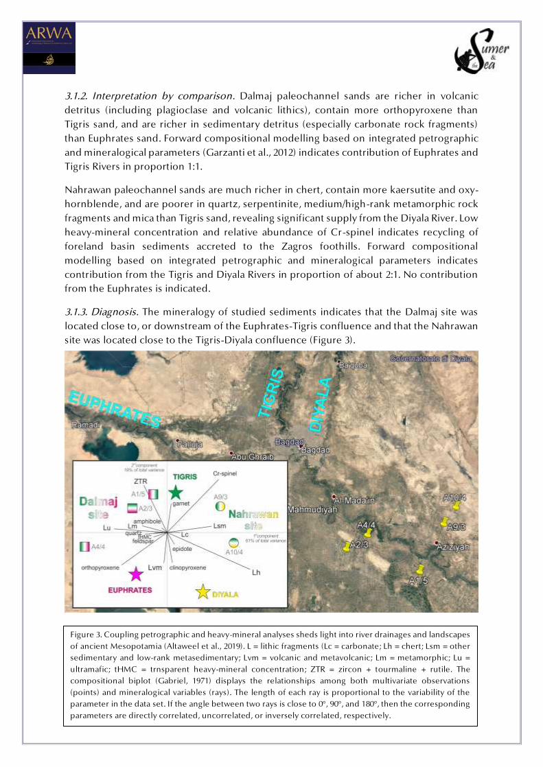
3.1. Dalmaj and Nahrawan Paleochannel Sites (Altaweel et al., 2019)
3.1.1. Petrographic and heavy mineral data. Sands collected in the Dalmaj and Nahrawan
paleochannel sites (Figure 2) have both quartzo-feldspatho-lithic sedimentaclastic
composition (classification after Garzanti, 2019) but can be clearly distinguished based
principally on their diagnostic rock-fragment populations and heavy-mineral suites.
The three samples collected in the Dalmaj site (A1/5, A2/3, A4/4) have higher quartz, higher
monocrystalline/polycrystalline quartz ratio, higher K-feldspar, higher volcanic grains,
higher plutonic rock fragments, higher medium-rank to high-rank metasedimentary grains,
and higher MI* and MI indices. Cellular serpentinite and serpentineschist grains are
common and particularly distinctive. Micas are quite common, with biotite dominating
over muscovite. Moderately rich heavy-mineral assemblages include minor hypersthene
and rare enstatite.
The two samples collected in the Nahrawan site (A9/3, A10/4) have very high carbonate
grains (but lower dolostone/total carbonate ratio) and much more abundant chert than
Dalmaj sands. Shale/slate and siltstone/metasiltstone grains are locally very common.
Moderately poor heavy-mineral assemblages include more Cr-spinel and a little more
epidote and prehnite. The higher HCI index reflects common presence of kaersutite and
oxy-hornblende.
Figure 2. Location of samples collected in the Dalmaj and Nahrawan
paleochannel sites (Altaweel et al., 2019).
9
Figure 3. Coupling petrographic and heavy-mineral analyses sheds light into river drainages and landscapes
of ancient Mesopotamia (Altaweel et al., 2019). L = lithic fragments (Lc = carbonate; Lh = chert; Lsm = other
sedimentary and low-rank metasedimentary; Lvm = volcanic and metavolcanic; Lm = metamorphic; Lu =
ultramafic; tHMC = trnsparent heavy-mineral concentration; ZTR = zircon + tourmaline + rutile. The
compositional biplot (Gabriel, 1971) displays the relationships among both multivariate observations
(points) and mineralogical variables (rays). The length of each ray is proportional to the variability of the
parameter in the data set. If the angle between two rays is close to 0°, 90°, and 180°, then the corresponding
parameters are directly correlated, uncorrelated, or inversely correlated, respectively.
3.1.2. Interpretation by comparison. Dalmaj paleochannel sands are richer in volcanic
detritus (including plagioclase and volcanic lithics), contain more orthopyroxene than
Tigris sand, and are richer in sedimentary detritus (especially carbonate rock fragments)
than Euphrates sand. Forward compositional modelling based on integrated petrographic
and mineralogical parameters (Garzanti et al., 2012) indicates contribution of Euphrates and
Tigris Rivers in proportion 1:1.
Nahrawan paleochannel sands are much richer in chert, contain more kaersutite and oxy-
hornblende, and are poorer in quartz, serpentinite, medium/high-rank metamorphic rock
fragments and mica than Tigris sand, revealing significant supply from the Diyala River. Low
heavy-mineral concentration and relative abundance of Cr-spinel indicates recycling of
foreland basin sediments accreted to the Zagros foothills. Forward compositional
modelling based on integrated petrographic and mineralogical parameters indicates
contribution from the Tigris and Diyala Rivers in proportion of about 2:1. No contribution
from the Euphrates is indicated.
3.1.3. Diagnosis. The mineralogy of studied sediments indicates that the Dalmaj site was
located close to, or downstream of the Euphrates-Tigris confluence and that the Nahrawan
site was located close to the Tigris-Diyala confluence (Figure 3).

10
CITED REFERENCES
Altaweel, M., Marsh, A., Jotheri, J., Hritz, C., Fleitmann, D., Rost, S., Lintner, S., Gibson, McG.,
Bosomworth, M., Jacobson, M., Garzanti, E., Limonta, M., Radeff, G., 2019.
New insights on the role of environmental dynamics shaping southern
Mesopotamia: From the Pre-Ubaid to the Early Islamic Period. Iraq,
doi:10.1017/irq.2019.2, 24 p.
Andò , S., 2020. Gravimetric separation of heavy-minerals in sediments: Minerals, v. 10(3),
no. 273, doi:10.3390/min10030273.
Dickinson, W.R., 2006. Temper sands in prehistoric Oceanian pottery: geotectonics,
sedimentology, petrography, provenance. Geological Society of America,
Special Paper 406, 164 p., doi:10.1130/2006.2406.
Gabriel, K.R., 1971. The biplot graphic display of matrices with application to principal
component analysis. Biometrika, 58, 453-467
Garzanti, E., 2019. Petrographic classification of sand and sandstone. Earth-Science Reviews,
192, 545-563.
Garzanti, E., Andò , S., 2007. Heavy-mineral concentration in modern sands: implications for
provenance interpretation. In Mange, M.A., and Wright, D.T. (eds.), Heavy
Minerals in Use. Elsevier, Amsterdam, Developments in Sedimentology
Series, 58, 517-545.
Garzanti, E., Andò , S., 2019. Heavy Minerals for Junior Woodchucks. Minerals, 9(3), n°148,
doi:10.3390/min9030148.
Garzanti, E., Vezzoli, G., 2003. A classification of metamorphic grains in sands based on their
composition and grade. Journal of Sedimentary Research, 73, 830-837.
Garzanti, E., Resentini, A., Vezzoli, G., Andò , S., Malusà, M., Padoan, M., 2012. Forward
compositional modelling of Alpine orogenic sediments. Sedimentary
Geology, 280, 149-164.
Garzanti, E., Vermeesch, P., Andò , S., Vezzoli, G., Valagussa, M., Allen, K., Khadi, K.A., Al-
Juboury, I.A., 2013. Provenance and recycling of Arabian desert sand. Earth-
Science Reviews, 120, 1–19.
Garzanti, E., Al-Juboury, A.I., Zoleikhaei, Y., Vermeesch, P., Jotheri, J., Akkoca, D.B., Allen,
M., Andò , S., Limonta, M., Padoan, M., Resentini, A., Rittner, M., Vezzoli, G.,
2016. The Euphrates-Tigris-Karun river system: provenance, recycling and
dispersal of quartz-poor foreland-basin sediments in arid climate. Earth-
Science Reviews, 162, 107-128.
Mange, M.A., Bezeczky, T., 2007. The provenance of paste and temper in Roman amphorae
from the Istrian Peninsula, Croatia. In: Mange, M., Wright, D. (eds.), Heavy
Minerals in Use. Elsevier, Amsterdam, Developments in Sedimentology
Series, 58, 1007-1033.

11
Reed Goodman & Liviu Giosan - University of Pennsylvania and Woods Hole Oceanographic
Institution; [email protected]; [email protected]
THE TIGRIS-EUPHRATES DELTAIC COMPLEX AND ITS RELATION TO THE LAGASH FLOODPLAIN
Settlement in Mesopotamia was determined by the size and distribution of its river
channels, most notably the Tigris and Euphrates. But the delta(s) these rivers built, and the
unique ecological setting that followed, resulted from an interplay between coastal (sea
level) and fluvial (river) processes. This dynamic exchange supplied the necessities of life,
and their location: from the basics of land and water to the more unknowable but no less
significant specifics of nutrient fluxes and biota. To understand what this landscape looked
like at critical points in history, we need to model the formation and evolution of the entire
Tigris-Euphrates deltaic complex. We also need to define delta type. Beginning with the
worldwide initiation of deltas brought on by a deceleration in sea-level rise, Iraq’s southern
alluvium developed in a process that continues today, in fits and starts. The growth of the
Karun-Karkeh alluvial fan in Khuzestan would play a role just as important as those in the
Tigris and Euphrates basin. This paper considers the timing and location of these events
over the longue durée, with a particular focus on the period of the first cities. Analysis of
geoarchaeological data recently collected from the Lagash region will be presented and
contextualized with previous studies to better explain the state of Lagash in the 3rd-
millennium BCE, including shifts in demography, political alliances and seats of power, as
well as its proximity to the sea.
Abdulameer al-Hamdani – State University of New York at Stony Brook (USA) and Durham University
(UK); [email protected], [email protected]
ETHNO-ARCHAEOLOGICAL MODELS OF WATERSCAPE AND LANDSCAPE IN THE MARSHES OF SOUTHERN
IRAQ
The paper will present ethno-archaeological models of waterscape and landscape in the
marshes of southern Iraq that could be applied in antiquity and can enhance our
understanding of settlement and canal system most-southern part of Sumer.
Taher al-Hosseini – Iraqi State Board for Antiquities and Heritage; [email protected]
ARCHAEOLOGICAL ACTIVITIES IN DHI-QAR AND LEGISLATIVE FRAME
The first part of the paper will present the work of the joint archaeological missions active
in Dhi-Qar Province and the efforts carried out by the archaeologists of Iraqi State Board
of Antiquities and Heritage in assisting the foreign teams. The second part of the speech
will introduce the Iraqi Antiquities and Heritage law in order to provide a comprehensive
normative frame for the archaeological missions working in the Country.

12
Jaafar Jotheri - University of Al-Qadisiyah; [email protected]
CHANGING RIVER COURSES AND THEIR RELATIONSHIP TO SETTLEMENTS
Several river avulsions have been identified, five for the Euphrates and six for the Tigris. It
has been found that these avulsions contributed to the shaping, formation and aggradation
of both the ancient and present–day landscapes of the floodplain. Two kinds of avulsion
have taken place in the floodplain, re-occupational and progradational. In the first of these
types of avulsion, the major flow diverted into a previously existing channel. In contrast,
the progradational avulsion began by inundating a large section of the floodplain between
elevated ridges, producing prograding deposits that filled topographic lows of the
floodplain.
These avulsions have affected the distribution, flourishing and degradation of human
settlements of the southern Mesopotamian civilisations. The present study has
demonstrated how human impact played a leading role in distribution of sediments across
the floodplain and shaping both the Holocene and the recent landscapes of the
Mesopotamian floodplain. By using periods of human occupation of archaeological sites
to date associated palaeochannels, we can get acceptable accuracy on their timing and
duration, and can give clear indications about the activity of a given channel.
Chris Morhange & Alexandra Bivolaru (AMU) & Daniela Cottica (Venice) & David Kaniewski
(Toulouse) & Nick Marriner (CNRS) & Hadeer Sheisha (AMU) & Gamal Younes (AMU)" - Aix-
Marseille University (AMU) & IUF hon. (Institut Universitaire de France); [email protected]
GEOARCHAEOLOGY OF FLUVIAL HARBORS. CASE STUDIES: ISONZO DELTA (AQUILEIA, ITALY), DANUBE
DELTA (NOVIODUNUM, HALMYRIS, ORGAMÉ, ROMANIA) AND THE NILE (GIZA, EGYPT).
In fluvial areas, at base level, under a context of relative sea-level stability during the past
6,000 years, one important question relates to the impact of environmental conditions on
human settlements around rivers and estuaries. Historiography has developed a number
of deterministic models but how do these fair in the light of recent palaeo-environmental
data? What was the impact of these occupations on the evolution of fluvial environments?
How did ancient societies use and overcome, or not, the environmental potentialities and
specific constraints linked to the occupation of these environments, including accessibility,
navigation conditions, sediment infilling and floods. Here we present some recent
multidisciplinary case study examples of fluvial harbours. We attempt to estimate the
weight of natural forcing agents on the different harbour sites and underline the important
roles of environmental changes and the sedimentary infilling of the ports at different spatial
scales. These processes impacted upon the infrastructure and the viability of the harbours
to varying degrees.

13
Galina S Morozova - School of Environmental Sciences, University of Guelph, 50 Stone Rd E, Guelph,
Ontario, Canada N1G 2W1; [email protected]
AVULSION STYLES, CHANNEL NETWORKS, FLOODING, AND BRONZE AGE SETTLEMENT PATTERNS IN
LOWER MESOPOTAMIA
Bronze Age civilizations of lower Mesopotamia, Egypt, and Indus valley emerged in an arid
and semi-arid climate and critically depended on river channel networks and irrigation for
their survival. In lower Mesopotamia, urban settlements appeared during a period of rapid
Tigris-Euphrates delta progradation following post-glacial marine transgression of the Gulf.
The low-gradient deltaic plain with elevated alluvial ridges was a favorable site for
avulsions. The Euphrates and Tigris avulsions changed the positions of river courses over
time. Avulsion styles (incision, progradation, annexation) affected channel network types
(single- or two-channel vs multiple-channel), the duration & extent of floodplain flooding,
and the resulting sedimentation patterns.
The earliest urban settlements in the delta pre-dated large-scale artificial irrigation by
hundreds of years. Unlike rural settlements that could be sustained by small-scale
‘crevasse’ irrigation, emerging cities required the generation of food surplus provided by
large nearby naturally-irrigated areas that could be readily transformed into farmland with
high agricultural productivity. Avulsions by incision and annexation created single-channel
or two-channel patterns and did not result in long-term floodplain flooding. On the other
hand, during progradational avulsions, large sections of a deltaic plain were flooded by
avulsion lakes, multiple-channel networks (distributary and/or anastomosed) developed
feeding splay complexes and lacustrine deltas and depositing sandy and silty sediment.
Avulsion lakes can cover ~102-103 km2 and form during large floods when the flow breaks
through the levee and inundates low-lying floodbasins. On poorly-drained floodplains,
avulsion lakes last for centuries until they are filled with sediment and their multiple -
channel feeder networks are abandoned. Changes in avulsion styles and disappearance of
avulsion lakes as a result of the Tigris-Euphrates delta evolution combined with increased
climate aridity led to the decline of many ancient cities, major population migrations, and
changes in settlement patterns. Urban settlements have since been sustained by large-scale
artificial irrigation.
Arsalan Othman - Iraq Geological Survey; [email protected]
DETERMINATION OF THE ANCIENT SHORELINE AND ANTHROPOGENIC SITES USING REMOTE SENSING
TECHNIQUES
Besides the neotectonic and erosional activities, the sea level could be changed as a result
of climate fluctuations. It is the case of the Gulf sea level, which changed during the
geological evolution of the Tigris–Euphrates delta in the Holocene epoch. Several
researches proposed that the shoreline of the Gulf was about 260 and 270 km north of the
present-day shoreline at 6000 yr. BP. If so, the Ur, Uruk, Lagash, Girsu, Bad-tibira, Larsa,
14
Eridu, and Susa would have been covered by the seawater, which is not the fact. On other
hand, these researchers agreed that these sites are coastal cities. This study comes to
modify the previous shoreline suggestion and give visualization to the boundaries of the
Gulf shoreline during the Sumerian period using remote sensing and GIS techniques.
Moreover, we used the same techniques to detect anthropogenic sites. This study highly
recommends using remote sensing data and GIS techniques with accurate methodologies
and data processing to give a clear overview of the archaeological sites.
Adelheid Otto & Berthold Einwag & Jörg Fassbinder - LMU Munich [email protected]; [email protected];
WATERWAYS AT SHURUPPAK AND UR. NEW IDEAS FROM OLD SITES
Renewed investigations at Ur and at Fara, ancient Shuruppak, included geophysical
prospections and a survey of the lower towns. These have brought to light structures which
– combined with archaeological evidence and in comparison with textual evidence and
archaeological evidence at other sites – can be tentatively identified with canals, a harbour
with a quay wall, and possibly a bridge. The joint paper by Jörg Fassbinder, Berthold Einwag
and Adelheid Otto will present the combined geophysical, archaeological and historical
data of the structures.
Jennifer R. Pournelle - University of South Carolina; [email protected]
ISLANDS IN THE STORM. TURTLEBACKS, TELLS, AND MARSHLAND CITIES
Especially problematic in understanding interactions between Sumerians and their water -
dominated environments is resolution of spatial and temporal scales. Deltaic, and
especially estuarine, evolution is highly variable on both measures, whether recorded in
human or geological time.
Answers to fundamental questions regarding urban emergence (Why here, and why not
there?), persistence (Why now, and not earlier or later?), and lifespan (Why growth? Why
decline? Why abandonment?) depend, first and foremost, on validating when and where
both necessary and sufficient conditions for construction and maintenance of the
architectures, enduring institutions, and material practices subsumed under the concept
of civil societies existed and endured.
In this overview, I will revisit the state-of-the-field regarding the relationships among
marine incursion and withdrawal, deltaic progradation and inundation, and cities and
settlements in the Euphrates-Tigris-Karkeh-Karun delta. Two decades ago, that floods, sea-
level fluctuations, climatic changes, and storm events left lasting impressions in arts,
literature, accounting records, and physical landscapes was not contentious --- but the
overarching wetland nature of those landscapes was contentious indeed.

15
In this overview, I will return to the model of “turtleback” towns I first posited in around
2001. Following a brief review of wetland urbanization in the Chari basin (Chad), the Nile
Delta, and Sumer, I present and discuss sedimentary core facies reconstructed from a
comprehensive literature review of the T-E-K-K case, in order to more fully model the
evolution of an idealized Sumerian marshland settlement as it endures as an urban center,
declines in importance, or vanishes entirely under coupled anthropogenic –
geomorphologic influences.
Philippe Quenet -University of Strasbourg - CNRS-UMR 7044; [email protected]
ERIDU AND THE SEA: A LONG-STANDING ISSUE
Since the very beginning of fieldwork research at Eridu the question arose as to its relation
to the sea. The site might never have been near the sea shore but obviously developed in
a changing and maybe alternating environment, from wetlands to a fluvial valley to a near-
desert in the present days.
Licia Romano & L. Forti & Franco D’Agostino & S. Milli- Sapienza University of Rome and Università
degli Studi di Milano [email protected] –[email protected]; [email protected]
DRILLING IS NOT BORING: GEOARCHAEOLOGICAL RESEARCH AT ABU TBEIRAH
The paper will introduce the geo-archaeological research carried out at Abu Tbeirah. The
presence of natural channels outside the city and artificial canals and water related facilities
inside it will be analysed first on the basis of satellite imagery. The evidence will be then
compared with the results obtained on the field. The environmental setting of the site and
the evolution of the palaeo-channel crossing Abu Tbeirah will be described and connected
to the history of the settlement. As final part of the paper, the experience gained during
our field research at Abu Tbeirah will be shared, highlighting the practical issues
encountered and the solutions undertaken.
Stephanie Rost - City University of New York ; [email protected]
MANAGING THE ANCIENT TIGRIS IN THE LATE 3RD AND EARLY 2ND
MILLENNIUM BC.
This paper will present the results of the study of cuneiform administrative documents on
the management of water courses in the Umma Province of the Ur III period (2112-2004
B.C.). It describes the integrated water management system that was adopted in ancient
Umma during the late 3rd and early 2nd millennium BC, which controlled the ancient Tigris
and its tributary not only for irrigation but also for river navigation and flood control. While
irrigation was crucial for the production of the much-needed agricultural surplus, water
born transportation enabled efficient distribution throughout the state and its urban
centers. Furthermore, given that peak flooding of the Euphrates and Tigris coincides with
the harvest, flood control was essential for the economic health of the Ur III state. The

16
second part of this paper will discuss how the question of water management in this region
will be investigated from a geomorphological and archaeological point of view in the
framework of the ongoing Umma Survey Project.
Susanne Rutishauser & Sebastian Borkowski - Universität Bern, Inst. fü r Archäologische
Wissenschaften - [email protected]; [email protected]
THE «RIVERS OF MESOPOTAMIA» RESEARCH PROJECT
Throughout the millennia, the physical landscape of the Mesopotamian alluvial plain has
altered continuously due to ever-shifting rivers and periodic flooding, as well as human
endeavors to secure prosperity and meet the economic needs of growing populations in a
semi-arid climate. The topography of the alluvial plain still bears witness of the close
entanglement of these past natural and anthropogenic processes. Spatial patterns of
archaeological sites indicate long-gone watercourses. And the construction of canals, the
maintenance of dams, inland navigation routes, etc. are well documented by cuneiform
texts from different periods. Over the last six decades, archaeologists, geoscientists, and
cuneiformists have contributed pathbreaking studies on the reconstruction of
Mesopotamia’s ancient riverscapes. However, there remains an enduring demand for
further basic research — especially in light of new technologies and today’s standards for
accessible and reusable digital data. Thus, in January 2019 the research project «Rivers of
Mesopotamia» (RIMES) started at the University of Bern with the aim of displaying the
various and heterogenous data on former river systems in Lower Mesopotamia in
interactive and dynamic web-maps and network visualizations. With this in mind, our
research mainly focuses on remote sensing and mapping of paleochannels and network
analysis of rivers and canals in historic text sources (primarily from the Ur III period). By
including data on settlement occupation from published surveys and linking the respective
geo-spatial, temporal and semantic data with one another, we pursue a holistic approach
to improve the knowledge on the dynamic layout of the riverscape of ancient
Mesopotamia. Our paper outlines the methodology of the «Rivers of Mesopotamia»
project and provides an initial insight into the current state of our research.
Lorenzo Verderame - Sapienza University of Rome; [email protected]
FROM THE MARSHES TO THE SEA: THE WATERSCAPE OF ANCIENT SUMER
The urbanized landscape of ancient Mesopotamia, which is the only one that the texts
describe in detail, is dominated by the water element. Canals and rivers cross and connect
the Southern Mesopotamian cities. What’s more, these cities lie on the seacoast or in the
midst of lagoons and marshes. In my paper, I discuss passages from Sumerian literary texts
and royal inscriptions dealing with this unique waterscape. I analyze the evidence from
different points of view, from economy to ecology, from politics to religion, to illustrate
that the trinomial marsh - lagoon - sea constitutes a continuum where the elements follow
each other without interruption.

17
Jan Walstra - Geological Survey of Belgium, Royal Belgian Institute of Natural Sciences, Brussels,
Belgium ([email protected]), Archaeology of Ancient Mediterranean and Near Eastern
Cultures, University of Konstanz, Konstanz, Germany
RECONSTRUCTING LANDSCAPE EVOLUTION IN THE HINTERLAND OF CHARAX SPASINOU, THE CAPITAL
OF MESENE
From its foundation to its heydays as trading hub and to its final abandonment, the history
of Charax Spasinou was intimately connected with the evolution of the river systems of the
southernmost part of the Mesopotamian plain and the shoreline of the Gulf .
This ongoing research, which is part of the Charax Spasinou Project of the Universities of
Konstanz and Manchester supported by the German Research Foundation and the Culture
Protection Fund of the British Council, aims to reconstruct the evolution of the landscape
and palaeoenvironment around the capital of Mesene, by combining evidence from
remote sensing data and geological coring. Here, results from the analysis of satellite
imagery and a preliminary field campaign carried out in 2018 will be presented.
It will be demonstrated that a combined geological and archaeological survey in the wider
hinterland of Charax allows an accurate reconstruction of the ancient watercourses and the
landscape of Mesene, in which the capital was the nodal point for nearly a millennium.


![Aral.pan. [Kabihasnang Sumer]](https://img.pdfslide.net/doc/110x75/552c519b5503468c0f8b4719/aralpan-kabihasnang-sumer.jpg)