Embed Size (px)
Citation preview
, y e, . - ,
,
Mr. L. C. Dail August 15, 1975Duke Power Company
Do NC arlot e, t orth Carolina 28201 /off/RE: Jocassee Hydro Consulting Board Meeting g_f g .
*
Fi1e No. J-4..
Dear Mr. DaII:,
The Board met on Thursday, May 15, 1975 at the Jocassee si te. The dam and
abutments were inspected. The data on settlement, seepage readings, and.
other aspects of dam performance were studied. The following summarizesour discussions, conclusions and recommendations:
1. Jocassee Embankment.
Horizontal Movement of the embankment crest has been measureda.at surf ace monuments on the downstream f ace of the dam, 20 feet
from the base line or about 3 feet below the theoretical crest.Measurements by transit since June, 1973 have shown a maximummovement in a downstream direction of approximately 1.5 feet.More accurate measurements by theodolite have shown a maximum
downstream movement of 0.46 feet (at Sta.13+00) accumulatedbetween July 12, 1974 and May 9, 1975. Movements at stations11+00 and 15+00 (within the riverbed and the. highest reach of
'he dam) were 0.42 feet. It was noted that during the periodwhen horizontal movement of surf ace monuments was made both by
transit and theodolite that the movements were comparable. Also,these movements are of similar magnitude as on other ccmparablerock fill dams. As expected, there is a gradual decline in the
rate of movement.,
b. Vertical Settlement of the embankment has been measured by threej
separate arrangements: Cross-arm devices (2) mainly in the core,4
surf ace monuments (noted in a), and pins set for measurementsacross the crack at the upstream f ace (deflection devices, so-
_
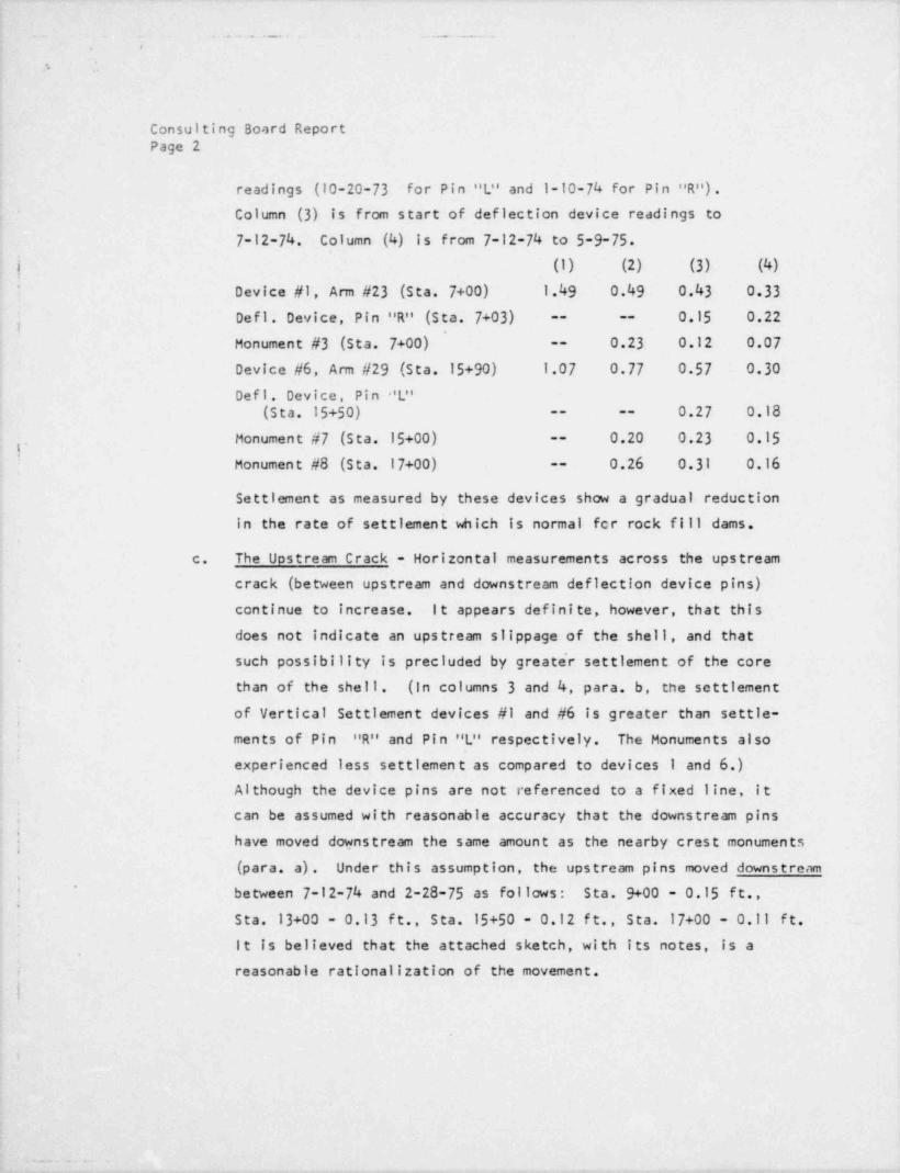
called). The following is a comparison of the settlement (infeet) . Column (1) is for the period 9-27-72 (start of highest cross-armreadings) to 7-1-73 (start of surf ace monument readings). Column(2) is for the period 7-1-73 to start of deflection device
,
18121809 7 3. . .
. . . . . _ . - . _ _ . . _ . _ . .
..
.
Consulting Bo,1rd ReportPage 2
readings (10-20-73 for Pin "L" and 1-10-74 for Pin "R") .Column (3) is from start of deflection device readings to
7-12-74. Column (4) is from 7-12-74 to 5-9-75.
| (1) (2) (3) (4)' Device #1, Arm #23 (Sta. 7+00) 1.49 0.49 0.43 0.33
Defl . Device, Pin "R" (Sta. 7+03) 0.15 0.22-- --
,
Monument #3 (sta. 7+00) 0.23 0.12 0.07--
Device #6, Arm #29 (sta.15+90) 1.07 0.77 0.57 0.30Defl . Device, Pin 'L"
0.27 0.18(sta. 15+50) -- --
Monument #7 (Sta. 15+00) 0.20 0.23 0.15--
1'
Monument #8 (Sta. 17+00) 0.26 0.31 0.16--
Settienent as measured by these devices show a gradual reductionin the rate of settlement which is normal for rock fill dams,
c. The Upstream Crack - Horizontal measurements across the upstreamcrack (between upstream and downstream deflection device pins)
continue to increase. i t appears defini te, however, that this
does not Indicate an upstream slippage of the shell, and that~
such possibility is precluded by greater settlement of the core-
than of the shell . (in columns 3 and 4, para, b, tne settlementof Vertical Settlement devices #1 and #6 is greater than settle-
;
ments of Pin "R" and Pin "L" respectively. The Monuments also'
~
experienced less settlemen t as compared to devices 1 and 6.)Although the device pins are not referenced to a fixed line, it
; can be assumed with reasonable accuracy that the downstream pins<
j have moved downstream the same amount as the nearby crest monuments
(para a) . Under this assumption, the upstream pins moved downstream~ between 7-12-74 and 2-28-75 as fol lows : s ta. 9+00 - 0.15 f t. ,
Sta. 13+00 - 0.13 ft., Sta. 15+50 - 0.12 ft., sta. 17+00 - 0.11 ft. _
d
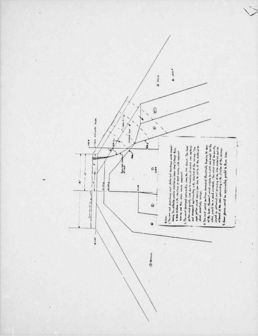
it is believed that the attached sketch, with its notes, is a
reasonable rationalization of the movement.-
I
3
|
___ . -|
.
,.__ _______ _ _
_ ,
*
.
Consulting Board ReportPage'3
Downstresm movement of rock fill dams has been reported in theli terature and similar cracking has occurred. Information was
found regarding Cherry Valley, Mud Mountain, Wautauga and
South Hols ton in the USA plus Gepatsch in Austria - all centercore dams; also, regarding the seven sloping core dams builtin western North Carolina by Alcoa. Cracking was generally
attributed to differential settlement between shell and corebut, since no measurements of shell settlement were made, itis possible that this explanation given above for Jocassee is morereal i s ti c. The settlement di f ferential might, however, have been greaterat Jocassee than at the others as a result of compaction, by vibration,of the shell materials in Jocassee.
There has been no significant difficulty with any similar damsand the Jocassee movement, considering heights and designs, isconsistent wi th them. Moreover, a stability check alcag an
assumed circular slip surfaces in the upstream rock fill,coinciding with the crack near the crest surface, with itsdeepest point at Elev.1070 and assuming sudden drawdown toElev.1080 shows a satisf actory safety f actor of about 1.31.
The Board concludes:
|i. Hovements of the embankment are not abnormal . Their causes
and the changed geometry of the structure can be rationalized.
11. Apprehension regarding a serious slip in the embankment hasbeen largely dissipated but continued moni toring of move-ments should be carried out as recommended below.
;- - - _.
ill. The slope indicator readings are consistent with this;
conclusion, merely assuming the core of the dam as the '
moving mass and the upstream shell as stationary, or movingless, rather than the reverse.
!
g. - -
... - . .
..
..
.
Consulting Board Report.Page 4
The Board recommends:
I. The longitudinal crack should be repaired by regradingof the crest and/or filling with gravel / filter material.
ii. 4nstall permanent monuments upstream of the crack in the
crest to take the place of the deflection device pins.,
These monuments should be placed at stations 7+00, 9+00,
.13+00 and 17+00.
: iii. Provide for frequent inspection of dam structure and
abu tmen ts . These should be periodic Inspections byqualified personnel, inspections should also be made
af ter severe storms and following a significant rapid
drawdown of the reservoir.
iv. The following instrumentation should be observed at threemonth Intervals.,
1) Vertical Settlement Devices,
'
i
| 5
|{ 2) Surface Monuments'i
a. Vertical Settlement(. b. Horizontal Movement! :
{ 3) Slope Indicator Readings'
| These readings should also be scheduled af ter severe storm,
and significant rapid drawdowns of the reservoir.
I v. Judgment should be made af ter one year as to whether theinstrument observation interval might be increased to six
months. After 2 additional years, judgment should be madeas to whether the observations might be discontinued altogether.

- . - . _ _ _ . _ _.
..
I
Consulting Board ReportPage 5
2. West Abutment.
The seepage as measured through the west abutment was observed tohave decreased since January 1, 1975 Weir F reduced from approxi-
;
mately 1200 GPM to '950 GPM, although the reservoir elevation during
this period remained relatively constant. It was noted that seepage;
flow in other weirs registered increases af ter heavy rainfall, butWeir F did not respond to these rainfall events. There is a strongpossibility of some seepage flow passing under the heavy rock fill
|
between Weir F-1 and Wei r F; thus not being recorded at Weir F.
| It does not appear possible to monitor this possible diversion.Also, other seepage may be passing under the dam directly to the
downstream toe.
During this period of time, sorne of the observation wells in thewest abutment (notable wells W-12 and W-18) have shown a considerabledecrease. Well W-18 went from elevation 1081.2 on 1-2-75 to eleva-tion 1072.5 on 4-15-75 (The reservoir elevation was about the same
for both dates.)
The Board inspected the west abutment on the upstream side, with the.,.
reservoir elevation at 1100+; joints in the weathered rock may bei
potential seepage paths.
The Board recomends:
f! Install a weir at a suitable location between Weirs F and1.
F-1 to eliminate possibility of diversion of seepage into,
-the rock fill ._ A good monitoring device, like Parshallflume, should be installed at uns point to facilitatecontinuous long-term monitoring.
: e
._ . . . _
-
I|
,
Consulting Board ReportPage 6
Re-establish observation.well W-6. .11.
Install an observation well between existing observation,
111.
wells V-12 and W-13 on station -0+50._,
Consideration should be given to grouting through the cracks ,
Iv. Efforts [in the bluf f rather than through drilled holes.should be made by underwater inspection to locate rock
joints or cracks in the bluff, which are responsible forThis could be achieved by scuba diving up to aboutseepage.
The diver should release30 feet below the reservoir level.dye near the face of the bluff by a squirt bottle and watch
Joints to befor dye movement into the cracks or rock joints.grouted can be identified by means of wooden pegs or steel
pins.
If the above proves unsuccessful, the reservoir may then belowered in one or two feet increments and the dye injected along
the water line.Where a definiteTwo types of grout should be considered.
flow is observed, a sIIIcate grout, which sets up rapidly andbecomes insoluble, should be used. For cracks in which there isno general suspicion of flow, but which might suggest Internal
neat cement grout could be used.connection wi thin the abutment,Grouting should be performed through barge-mounted equipment.
At the next meeting of the Board, the lake level should bev.
pulled down to permit a visual inspection of the cracks by boat.- - Information-on underwater inspection should be made available
at this time.
i
i
|
|.
e
!
. - - ,
i. - . . . - .
'
!.
l. .
1
|l1
Consulting Board Meeting )Page 7 |
;
3 The Board also inspected the recent erosion between intakes A and B.
Board recommends that fu.-ther erosion should be checked by buildinga concrete wall above the cleared ledge at elevation 1102+ and ;
backfilling with riprap.
4. The Board was informed that the pins installed on the rock face
upstream of Jocassee powerhouse did not show any movement. Board does
not see any need to continue this monitoring.
Yours very truly,|
.
[[ /d 4.m em
C. C. Cullum WF. V. Conn
rs|-/
[ F. Mowers
:!
.
- . .,
. -.,
-a--
w -
-\ 1
ft.,@
.
.
.
@
t.
4.
.
-
e
e
'
@ -~s .
N \i'3 '
2 a'sI s .
._'
21 s . . .
-
$- .s-'' yx 4*
*/ 8~ l b }3d,k
1' 4/ s
1 j1
til p g .c o. .'/ -
..a-
33 Apsu 1 114 2'
--~
/ >9 urliM itggl. li, 4
*
s ~~e a1
ilj4rji *f es-
)ptIP1;3gt.pd.t*J,,1. a- .~ .
-
. .' ",* .
jl I -I 1 s4,- g"g ,I JJ , pi'
s ag,
.,I-IMj[Al {,} }{.
4
It i O, 1 oII a3s3,,i ]
}}{j {' 1 ji 1)U[.#ied.!-
.< '
*
u.Li -
'
( ks. . , . 4
-
:i
_
< .. '
'
,
. ,
e
'
s
> *
*