Embed Size (px)
Citation preview

INTERNATIONAL FOOD POLICY RESEARCH INSTITUTE
The use of global databases in developing SWAT applications to Sub-Saharan Africa and South Asia for large-scale hydrological and crop simulation
Hua XiePostdoctoral Fellow
International Food Policy Research InstituteWashington D.C.August 5-7, 2009
1

Agricultural Water Management Solutions
2
• Identify promising investment options for smallholder irrigation in Sub-Saharan Africa and South Asia
Sub-Saharan Africa (SSA)
South Asia (SA)

Smallholder irrigation
3
• Irrigation technologies for smallholders (FAO)
• A `bottom-up' or `grass-roots' approach to development , and in contrast to formally structured irrigation schemes that are usually under the control of a government body (FAO)
— Water harvesting— Swamp irrigation— River flood plain irrigation— Spate irrigation— Hill irrigation— Groundwater irrigation

Smallholder irrigation
4
A field trip to Ziway, Ethiopia, May, 2009

Objectives of the SWAT modeling
5
• Perform hydrologic and crop simulation to evaluate the physical potentials of smallholder irrigation in terms of crop yields and environmental impacts at a continental scale
Meteorological data base (input)
Hydrology
Erosion, nutrients
& agricultural
chemicals
Crop/plant
growth
Water & land
management
SWAT
Information flow Control flow

Setting up the SWAT applications for Sub-Saharan Africa and South Asia
6
Databases
• HydroSHED — based on SRTM (Shuttle Radar Topography Mission) 90m
DEM database
• Harmonized World Soil Database v 1.1
• Global Lakes and Wetlands Database (Lehner and Döll, 2004)
• CRU (Climate Research Unit, University of East Anglia) database
• GRDC (Global Runoff Data Centre) database
• FAOSTAT
References— Schuol, J., K.C. Abbaspour, H. Yang, R. Srinivasan, and A.J.B. Zehnder
(2008), Modeling blue and green water availability in Africa, Water Resources Research, 44: 1-18
— WaterBase project (www. Waterbase.org)

Challenges in setting SWAT applications for Sub-Saharan Africa and South Asia
7
Elevation
• HydroSHED
SWAT GIS Interface
Delimited irrigation area
Land coverSoil
• Harmonized World Soil Database v 1.1
Lakes, wetlands and reservoirs
• Global Lakes and Wetlands Database
SWAT-SSA&SA
Model application
ClimateRunoff
Agriculture
• CRU• GRDC
• FAOSTAT

Challenges in preparing crop-specific land cover database for Sub-Saharan Africa and South Asia
8
• FAOSTAT
— statistically based
— crop specific, but not spatially disaggregated
• GLC 2000 and MODIS
— satellite based
— spatially disaggregated, but not crop specific
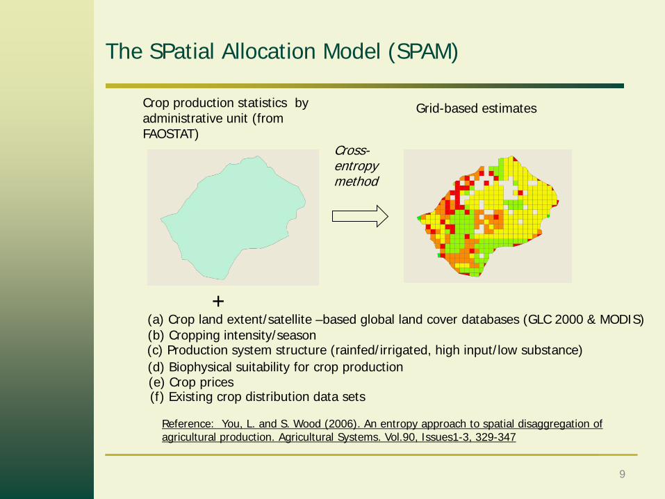
The SPatial Allocation Model (SPAM)
9
Cross-entropy method
Crop production statistics by administrative unit (from FAOSTAT)
(c) Production system structure (rainfed/irrigated, high input/low substance)(b) Cropping intensity/season(a) Crop land extent/satellite –based global land cover databases (GLC 2000 & MODIS)
(d) Biophysical suitability for crop production
(f) Existing crop distribution data sets
Grid-based estimates
+
Reference: You, L. and S. Wood (2006). An entropy approach to spatial disaggregation of agricultural production. Agricultural Systems. Vol.90, Issues1-3, 329-347
(e) Crop prices

The SPatial Allocation Model (SPAM)
10
Non-crop land
SPAM grid (10km×10km)
Crops1. Wheat 2. Rice3. Maize 4. Barley5. Millet 6. Sorghum7. Potato 8. Sweet potato and yams 9. Cassava 10. Plantain & banana11. Soybean 12. Beans13. Other pulse 14. Sugar cane
15. Sugar beets 16 Coffee17. Cotton 18. Other fibres
19. Ground nuts 20 Other oil crops
Rainfed & high input
Rainfed & low input
Irrigated
Area (ha), yield (ton/ha) & production (ton)

Delimit irrigation areas for SWAT modeling
11
• Hydrologic Response Units (HRUs) — basic spatial units in SWAT modeling
• HRUs are defined by overlaying soil, land cover and slope data layers
• An additional layer for irrigation area delimitation is compiled to help define the HRUs where irrigation could be applied
Land cover
Soil
Slope
Irrigation

Delimit irrigation areas for SWAT modeling
12
“Riparian” vs. “non-riparian” irrigation
Riparian irrigation cropland
Non-riparian irrigation cropland

Developing algorithms in SWAT modeling for simulating smallholder irrigation
13
Runoff Irrigated waterStorage
Smallholder irrigation • Water Harvesting• Swamp irrigation• River flood plain irrigation• Spate irrigation• Hill irrigationFormally structured irrigationDomestic & industrial water use
(Shen & Oki et al., University of Tokyo)
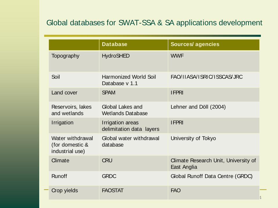
Global databases for SWAT-SSA & SA applications development
14
Database Sources/agencies
Topography HydroSHED WWF
Soil Harmonized World Soil Database v 1.1
FAO/IIASA/ISRIC/ISSCAS/JRC
Land cover SPAM IFPRI
Reservoirs, lakes and wetlands
Global Lakes and Wetlands Database
Lehner and Döll (2004)
Irrigation Irrigation areas delimitation data layers
IFPRI
Water withdrawal (for domestic & industrial use)
Global water withdrawal database
University of Tokyo
Climate CRU Climate Research Unit, University of East Anglia
Runoff GRDC Global Runoff Data Centre (GRDC)
Crop yields FAOSTAT FAO

15