Embed Size (px)
Citation preview
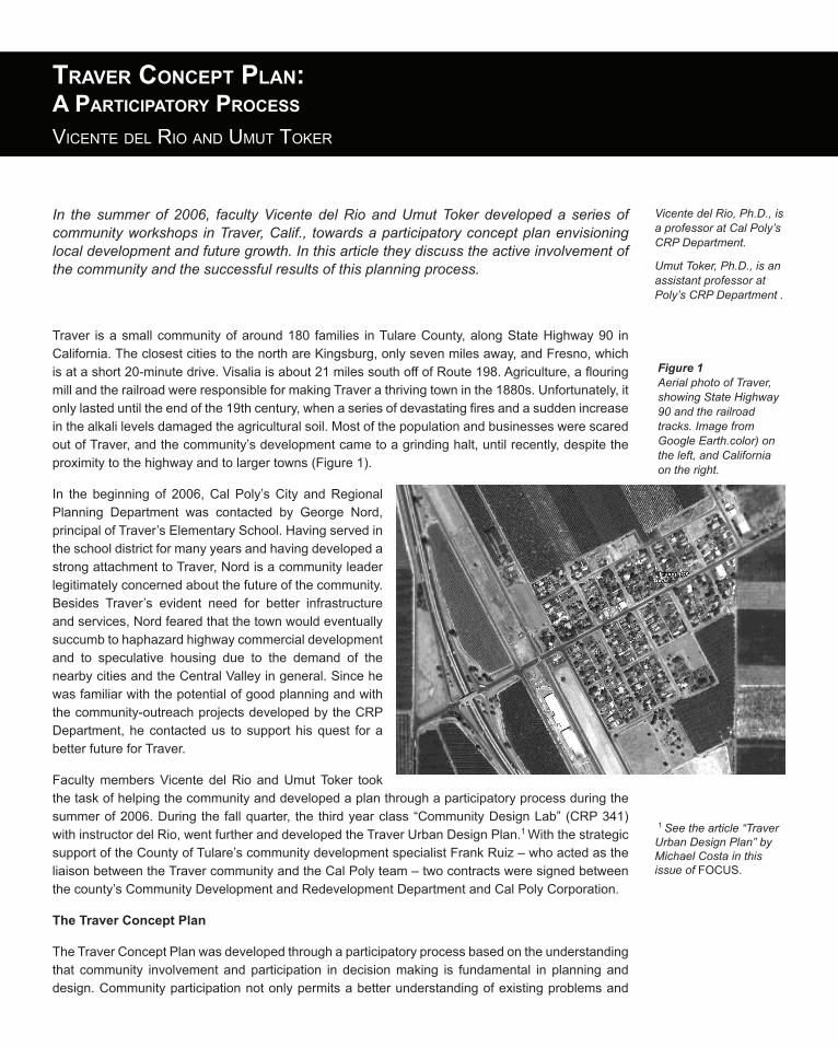
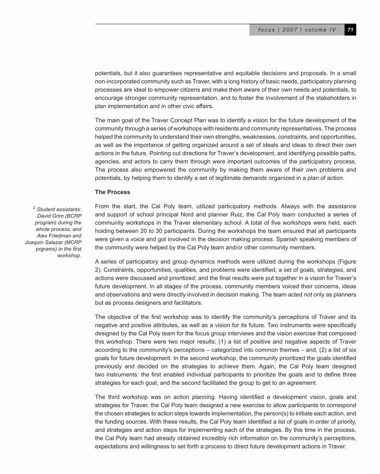
Traver is a small community of around 180 families in Tulare County, along State Highway 90 in California.TheclosestcitiestothenorthareKingsburg,onlysevenmilesaway,andFresno,whichis at a short 20-minute drive. Visalia is about 21 miles south off of Route 198. Agriculture, a flouring mill and the railroad were responsible for making Traver a thriving town in the 1880s. Unfortunately, it only lasted until the end of the 19th century, when a series of devastating fires and a sudden increase inthealkalilevelsdamagedtheagriculturalsoil.MostofthepopulationandbusinesseswerescaredoutofTraver,andthecommunity’sdevelopmentcametoagrindinghalt,untilrecently,despitetheproximity to the highway and to larger towns (Figure 1).
In the beginning of 2006, Cal Poly’s City and Regional Planning Department was contacted by George Nord,principalofTraver’sElementarySchool.HavingservedintheschooldistrictformanyyearsandhavingdevelopedastrongattachmenttoTraver,Nordisacommunityleaderlegitimatelyconcernedaboutthefutureofthecommunity.Besides Traver’s evident need for better infrastructureandservices,Nordfearedthatthetownwouldeventuallysuccumbtohaphazardhighwaycommercialdevelopmentand to speculative housing due to the demand of thenearbycitiesandtheCentralValleyingeneral.Sincehewasfamiliarwiththepotentialofgoodplanningandwiththecommunity-outreachprojectsdevelopedbytheCRPDepartment,hecontactedus tosupporthisquest forabetterfutureforTraver.
FacultymembersVicentedelRioandUmutToker tookthetaskofhelpingthecommunityanddevelopedaplanthroughaparticipatoryprocessduringthesummer of 2006. During the fall quarter, the third year class “Community Design Lab” (CRP 341) withinstructordelRio,wentfurtheranddevelopedtheTraverUrbanDesignPlan.1 WiththestrategicsupportoftheCountyofTulare’scommunitydevelopmentspecialistFrankRuiz–whoactedastheliaisonbetweentheTravercommunityandtheCalPolyteam–twocontractsweresignedbetweenthecounty’sCommunityDevelopmentandRedevelopmentDepartmentandCalPolyCorporation.
The Traver Concept Plan
TheTraverConceptPlanwasdevelopedthroughaparticipatoryprocessbasedontheunderstandingthat community involvement andparticipation in decisionmaking is fundamental in planninganddesign.Communityparticipationnotonlypermitsabetterunderstandingofexistingproblemsand
In the summer of 2006, faculty Vicente del Rio and Umut Toker developed a series of community workshops in Traver, Calif., towards a participatory concept plan envisioning local development and future growth. In this article they discuss the active involvement of the community and the successful results of this planning process.
Vicente del Rio, Ph.D., is a professor at Cal Poly’s CRP Department.
Umut Toker, Ph.D., is an assistant professor at Poly’s CRP Department .
Traver ConCepT plan:a parTiCipaTory proCess
ViCente del rio and umut toker
Figure 1Aerial photo of Traver, showing State Highway 90 and the railroad tracks. Image from Google Earth.color) on the left, and California on the right.
1 See the article “Traver Urban Design Plan” by Michael Costa in this issue of FOCUS.
71f o c u s | 2 0 0 7 | v o l u m e I V
potentials,butitalsoguaranteesrepresentativeandequitabledecisionsandproposals.Inasmallnon-incorporatedcommunitysuchasTraver,withalonghistoryofbasicneeds,participatoryplanningprocessesareidealtoempowercitizensandmakethemawareoftheirownneedsandpotentials,toencouragestrongercommunityrepresentation,andtofostertheinvolvementofthestakeholdersinplanimplementationandinothercivicaffairs.
ThemaingoaloftheTraverConceptPlanwastoidentifyavisionforthefuturedevelopmentofthecommunitythroughaseriesofworkshopswithresidentsandcommunityrepresentatives.Theprocesshelpedthecommunitytounderstandtheirownstrengths,weaknesses,constraints,andopportunities,aswellastheimportanceofgettingorganizedaroundasetofidealsandideastodirecttheirownactionsinthefuture.PointingoutdirectionsforTraver’sdevelopment,andidentifyingpossiblepaths,agencies,andactorstocarrythemthroughwereimportantoutcomesoftheparticipatoryprocess.The process also empowered the community by making them aware of their own problems andpotentials,byhelpingthemtoidentifyasetoflegitimatedemandsorganizedinaplanofaction.
The Process
From the start, the Cal Poly team, utilized participatory methods. Always with the assistanceandsupportofschoolprincipalNordandplannerRuiz, theCalPoly teamconductedaseriesofcommunity workshops in the Traver elementary school. A total of five workshops were held, each holding between 20 to 30 participants. During the workshops the team ensured that all participants weregivenavoiceandgotinvolvedinthedecisionmakingprocess.SpanishspeakingmembersofthecommunitywerehelpedbytheCalPolyteamand/orothercommunitymembers.
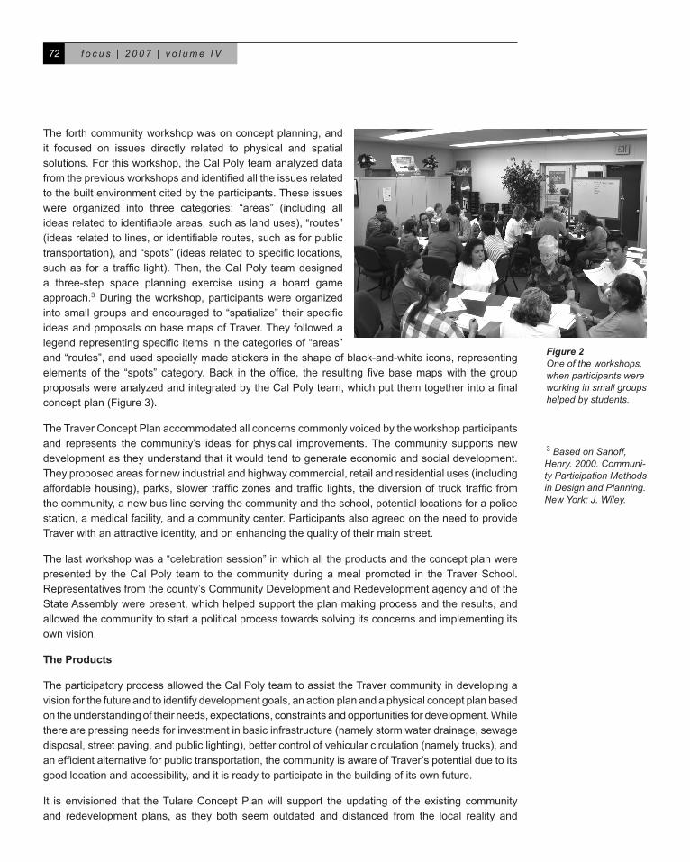
Aseriesofparticipatoryandgroupdynamicsmethodswereutilizedduringtheworkshops(Figure2). Constraints, opportunities, qualities, and problems were identified; a set of goals, strategies, and actions were discussed and prioritized; and the final results were put together in a vision for Traver’s futuredevelopment.Inallstagesoftheprocess,communitymembersvoicedtheirconcerns,ideasandobservationsandweredirectlyinvolvedindecisionmaking.Theteamactednotonlyasplannersbutasprocessdesignersandfacilitators.
The objective of the first workshop was to identify the community’s perceptions of Traver and its negative and positive attributes, as well as a vision for its future. Two instruments were specifically designedbytheCalPolyteamforthefocusgroupinterviewsandthevisionexercisethatcomposedthis workshop. There were two major results: (1) a list of positive and negative aspects of Traver according to the community’s perceptions – categorized into common themes – and, (2) a list of six goals for future development. In the second workshop, the community prioritized the goals identified previously and decided on the strategies to achieve them. Again, the Cal Poly team designedtwo instruments: the first enabled individual participants to prioritize the goals and to define three strategiesforeachgoal,andthesecondfacilitatedthegrouptogettoanagreement.
The third workshop was on action planning. Having identified a development vision, goals and strategiesforTraver,theCalPolyteamdesignedanewexercisetoallowparticipantstocorrespondthe chosen strategies to action steps towards implementation, the person(s) to initiate each action, and the funding sources. With these results, the Cal Poly team identified a list of goals in order of priority, andstrategiesandactionstepsforimplementingeachofthestrategies.Bythistimeintheprocess,theCalPolyteamhadalreadyobtainedincrediblyrichinformationonthecommunity’sperceptions,expectationsandwillingnesstosetforthaprocesstodirectfuturedevelopmentactionsinTraver.
2Student assistants: David Grim (BCRP
program) during the whole process, and Alex Friedman and
Joaquin Salazar (MCRP prgrams) in the first
workshop.
f o c u s | 2 0 0 7 | v o l u m e I V72
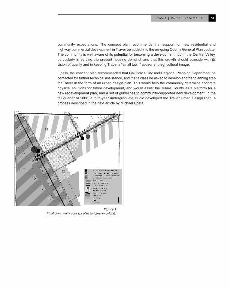
Theforthcommunityworkshopwasonconceptplanning,andit focused on issues directly related to physical and spatialsolutions.Forthisworkshop,theCalPolyteamanalyzeddatafrom the previous workshops and identified all the issues related tothebuiltenvironmentcitedbytheparticipants.Theseissueswere organized into three categories: “areas” (including allideas related to identifiable areas, such as land uses), “routes” (ideas related to lines, or identifiable routes, such as for public transportation), and “spots” (ideas related to specific locations, such as for a traffic light). Then, the Cal Poly team designed a three-step space planning exercise using a board gameapproach.3During theworkshop,participantswereorganizedinto small groups and encouraged to “spatialize” their specific ideasandproposalsonbasemapsofTraver.Theyfollowedalegend representing specific items in the categories of “areas” and“routes”,andusedspeciallymadestickersintheshapeofblack-and-whiteicons,representingelements of the “spots” category. Back in the office, the resulting five base maps with the group proposals were analyzed and integrated by the Cal Poly team, which put them together into a final concept plan (Figure 3).
TheTraverConceptPlanaccommodatedallconcernscommonlyvoicedbytheworkshopparticipantsand represents the community’s ideas for physical improvements.The community supports newdevelopmentastheyunderstandthatitwouldtendtogenerateeconomicandsocialdevelopment.Theyproposedareasfornewindustrialandhighwaycommercial,retailandresidentialuses(includingaffordable housing), parks, slower traffic zones and traffic lights, the diversion of truck traffic from thecommunity,anewbuslineservingthecommunityandtheschool,potentiallocationsforapolicestation,amedicalfacility,andacommunitycenter.ParticipantsalsoagreedontheneedtoprovideTraverwithanattractiveidentity,andonenhancingthequalityoftheirmainstreet.
Thelastworkshopwasa“celebrationsession”inwhichalltheproductsandtheconceptplanwerepresentedby theCalPoly team to thecommunityduringamealpromoted in theTraverSchool.Representativesfromthecounty’sCommunityDevelopmentandRedevelopmentagencyandoftheStateAssemblywerepresent,whichhelpedsupporttheplanmakingprocessandtheresults,andallowedthecommunitytostartapoliticalprocesstowardssolvingitsconcernsandimplementingitsownvision.
The Products
TheparticipatoryprocessallowedtheCalPolyteamtoassisttheTravercommunityindevelopingavisionforthefutureandtoidentifydevelopmentgoals,anactionplanandaphysicalconceptplanbasedontheunderstandingoftheirneeds,expectations,constraintsandopportunitiesfordevelopment.Whiletherearepressingneedsforinvestmentinbasicinfrastructure(namelystormwaterdrainage,sewagedisposal, street paving, and public lighting), better control of vehicular circulation (namely trucks), and an efficient alternative for public transportation, the community is aware of Traver’s potential due to its goodlocationandaccessibility,anditisreadytoparticipateinthebuildingofitsownfuture.
It isenvisioned that theTulareConceptPlanwill support theupdatingof theexistingcommunityand redevelopment plans, as they both seem outdated and distanced from the local reality and
Figure 2One of the workshops, when participants were working in small groups helped by students.
3Based on Sanoff, Henry. 2000. Communi-ty Participation Methods in Design and Planning. New York: J. Wiley.
7�f o c u s | 2 0 0 7 | v o l u m e I V
community expectations. The concept plan recommends that support for new residential andhighwaycommercialdevelopmentinTraverbeaddedintotheon-goingCountyGeneralPlanupdate.ThecommunityiswellawareofitspotentialforbecomingadevelopmenthubintheCentralValley,particularly in serving thepresenthousingdemand,and that thisgrowth should coincidewith itsvisionofqualityandinkeepingTraver’s“smalltown”appealandagriculturalimage.
Finally,theconceptplanrecommendedthatCalPoly’sCityandRegionalPlanningDepartmentbecontactedforfurthertechnicalassistance,andthataclassbeaskedtodevelopanotherplanningstepforTraverintheformofanurbandesignplan.Thiswouldhelpthecommunitydetermineconcretephysicalsolutionsfor futuredevelopment,andwouldassist theTulareCountyasaplatformforanewredevelopmentplan,andasetofguidelinestocommunity-supportednewdevelopment.Inthefall quarter of 2006, a third-year undergraduate studio developed the Traver Urban Design Plan, a processdescribedinthenextarticlebyMichaelCosta.
Figure �Final community concept plan (original in colors).

![Concept and Process Design for Participatory Regional Vulnerability Assessments: Lessons Learnt from Analysing Model Projects [Wolfgang Lexer]](https://img.pdfslide.net/doc/110x75/54c0655f4a7959610b8b45d4/concept-and-process-design-for-participatory-regional-vulnerability-assessments-lessons-learnt-from-analysing-model-projects-wolfgang-lexer.jpg)