Embed Size (px)
Citation preview
S M A R T C O D EH A R R I S O N C O U N T Y , M S
T1
T2
T3
T4
T5
T6
Harrison County, MississippiSMARTCODE
SMARTCODE VERSION 9.0
TABLE OF CONTENTS
ARTICLE 1. GENERAL TO ALL PLANS 1.1 INTENT 1.2 APPLICABILITY 1.3 PROCESS 1.4 VARIANCES 1.5 INCENTIVES ARTICLE 2. REGIONAL SCALE PLANS 2.1 INSTRUCTIONS 2.2 (O-1) PRESERVED OPEN SECTOR 2.3 (O-2) RESERVED OPEN SECTOR 2.4 (G-1) RESTRICTED GROWTH SECTOR 2.5 (G-2) CONTROLLED GROWTH SECTOR 2.6 (G-3) INTENDED GROWTH SECTOR 2.7 (G-4) INFILL GROWTH SECTOR 2.8 (SD) SPECIAL DISTRICTS
ARTICLE 3. NEW COMMUNITY SCALE PLANS 3.1 INSTRUCTIONS 3.2 TRANSECT ZONES 3.3 COMMUNITY TYPES 3.4 DENSITY CALCULATIONS 3.5 ENVIRONMENTAL REQUIREMENTS 3.6 STREETSCAPE REQUIREMENTS 3.7 CIVIC FUNCTIONS 3.8 SPECIAL REQUIREMENTS
ARTICLE 4. INFILL COMMUNITY SCALE PLANS 4.1 INSTRUCTIONS 4.2 COMMUNITY TYPES 4.3 TRANSECT ZONES 4.4 CIVIC ZONES 4.5 SPECIAL REQUIREMENTS 4.6 PRE-EXISTING CONDITIONS
ARTICLE 5. BUILDING SCALE PLANS 5.1 INSTRUCTIONS 5.2 SPECIFIC TO NATURAL AND RURAL
TRANSECT ZONES (T1 & T2) 5.3 SPECIFIC TO SUB-URBAN TRANSECT
ZONE (T3) 5.4 SPECIFIC TO GENERAL URBAN
TRANSECT ZONES (T4)
5.5 SPECIFIC TO URBAN CENTER TRANSECT ZONES (T5)
5.6 SPECIFIC TO URBAN CORE TRANSECT ZONES (T6)
5.7 CIVIC FUNCTIONS 5.8 SPECIAL REQUIREMENTS 5.9 PRE-EXISTING CONDITIONS
ARTICLE 6. STANDARDS & TABLES TABLE 1 TRANSECT ZONE
DESCRIPTIONS TABLE 2 SECTOR/COMMUNITY
ALLOCATION TABLE 3A VEHICULAR LANE DIMENSIONS TABLE 3B VEHICULAR LANE & PARKING
ASSEMBLIES TABLE 3C THOROUGHFARE ASSEMBLIES TABLE 4A PUBLIC FRONTAGES - GENERAL TABLE 4B PUBLIC FRONTAGES - SPECIFIC TABLE 5 PRIVATE FRONTAGES TABLE 6 BUILDING CONFIGURATION TABLE 7 BUILDING DISPOSITION TABLE 8 BUILDING FUNCTION TABLE 9 PARKING CALCULATIONS TABLE 10 SPECIFIC FUNCTION & USE TABLE 11 CIVIC SPACE TABLE 12 SMARTCODE SUMMARY TABLE 13 FORM-BASED CODE GRAPHICS TABLE 14 DEFINITIONS ILLUSTRATED
ARTICLE 7. DEFINITIONS OF TERMS
APPENDICESAPPENDIX A: TREES AND SHRUBS SUITABLE
FOR MISSISSIPPI GULF COASTAPPENDIX B: RESOURCES
Harrison County, MississippiSMARTCODE
SMARTCODE VERSION 9.0
ARTICLE 1. GENERAL TO ALL PLANS
2
1.1 INTENT The purpose of this Code is to enable, encourage and qualify the implementation
of the following policies:1.1.1 THE REGION
a. That the region should retain its natural infrastructure and visual character derived from topography, forestland, farmlands, riparian corridors, and coastlines.
b. That growth strategies should encourage Infi ll and redevelopment in parity with new communities.
c. That development contiguous to urban areas should be structured in the Neighborhood pattern and be integrated with the existing urban pattern.
d. That development non-contiguous to urban areas should be organized in the pattern of clusters, traditional Neighborhoods or Villages, and Regional Centers.
e. That affordable housing should be distributed throughout the region to match job opportunities and to avoid concentrations of poverty.
f. That transportation corridors should be planned and reserved in coordination with land use.
g. That green corridors should be used to defi ne and connect the urbanized areas.
h. That the region should include a framework of transit, pedestrian, and bicycle systems that provide alternatives to the automobile.
1.1.2 THE COMMUNITY a. That Neighborhoods and Regional Centers should be compact, pedestrian-
oriented, and mixed-use. b. That Neighborhoods and Regional Centers should be the preferred pattern
of development and that districts specializing in single-use should be the exception.
c. That ordinary activities of daily living should occur within walking distance of most dwellings, allowing independence to those who do not drive.
d. That interconnected networks of Thoroughfares should be designed to disperse and reduce the length of automobile trips.
e. That within Neighborhoods, a range of housing Types and price levels should be provided to accommodate diverse ages and incomes.
f. That appropriate building Densities and land uses should be provided within walking distance of transit stops.
g. That Civic, Institutional, and Commercial activity should be embedded in Downtowns, not isolated in remote single-use complexes.
h. That schools should be sized and located to enable children to walk or bicycle to them.
i. That a range of open space including parks, squares, and playgrounds should be distributed within Neighborhoods and urban center zones.
1.1.3 THE BLOCK AND THE BUILDING a. That buildings and landscaping should contribute to the physical defi nition of
Thoroughfares as Civic places. b. That development should adequately accommodate automobiles while respecting
the pedestrian and the spatial form of public space. c. That the design of streets and buildings should reinforce safe environments, but
Harrison County, MississippiSMARTCODE
SMARTCODE VERSION 9.0
ARTICLE 1. GENERAL TO ALL PLANS
3
not at the expense of accessibility. d. That architecture and landscape design should grow from local climate,
topography, history, and building practice. e. That buildings should provide their inhabitants with a clear sense of geography
and climate through energy effi cient methods. f. That Civic Buildings and public gathering places should be provided locations
that reinforce community identity and support self-government. g. That Civic Buildings should be distinctive and appropriate to a role more important
than the other buildings that constitute the fabric of the city. h. That the preservation and renewal of historic buildings should be facilitated to
affi rm the continuity and evolution of society. i. That the harmonious and orderly evolution of urban areas should be secured
through graphic codes that serve as guides for change.1.1.4 THE TRANSECT
a. That Communities should provide meaningful choices in living arrangements as manifested by distinct physical environments.
b. That the Transect Zone descriptions on Table 1 shall constitute the Intent of this Code with regard to the general character of each of these environments.
1.2 APPLICABILITY1.2.1 Provisions of this Code are activated by “shall” when required; “should” when
recommended; and “may” when optional. 1.2.2 This Code is an option for development of Communities and Neighborhoods in
Harrison County, Mississippi, and is intended to exist parallel to the existing Harrison County Unifi ed Development Code. It may, through the proper planning process, be made mandatory in certain districts of the County. The Harrison County Unifi ed Development Code and any Existing Local Harrison County Codes shall continue to be applicable to issues not covered by this Code except when in confl ict with the Intent Section 1.1, in which case the confl ict shall be resolved in favor of this Code for projects applied for and approved using this code.
a. This Code shall be available throughout the County for development and adoption of a New Community Plan or an Existing-Community Plan in accordance with Articles 1, 3, and 4 of this Code.
b. Within a Community Planning Area created by an adopted New Community Plan, the provisions of this Code and of the Community Plan shall both be applicable and mandatory.
c. Within a Community Planning Area covered by an Existing-Community Plan, in any district where this Code is optional and property owners chose not to use it, the existing local codes shall be applicable in all respects.
d. Within a Community Planning Area subject to an Existing-Community Plan, in any district where this Code either (a) is optional and property owners chose to use this Code, or (b) is made mandatory by the Community Plan, the provisions of Articles 1, 5, 6, and 7 of this Code and the requirements of the Community Plan shall be mandatory in all respects.
e. Any Community Planning Area governed by an Offi cial Community Plan in which this Code is mandatory, shall be designated on the Zoning Map of Harrison County, Mississippi, as a SmartCode Special Use District.
1.2.3 The Defi nitions of Terms (Article 7) contains regulatory language that is found in
Harrison County, MississippiSMARTCODE
SMARTCODE VERSION 9.0
ARTICLE 1. GENERAL TO ALL PLANS
4
this Code. Capitalized Terms in this Code may refer to defi nitions in Articles 1-5 or to Article 7 Defi nitions. Those terms not defi ned in Article 7 shall be accorded their commonly accepted meanings. In the event of confl icts between these defi nitions and those of the existing local codes, those of this Code shall take precedence for projects approved using this code.
1.3 PROCESS 1.3.1 Sectors (defi ned geographically in Article 2 and published in the Harrison County
Comprehensive Plan) contain Communities (defi ned by extent and intensity in Articles 3 and 4) which are comprised of Transect Zones (defi ned by the elements appropriate to them in Article 5 and in Article 6 Standards & Tables).
1.3.2 The geographic determination of Sectors and the standards for each Transect Zone shall be determined through a process of public consultation with approval by the Board of Supervisors.
1.3.3 The Harrison County, Mississippi Zoning Offi ce (the “Zoning Offi ce”) shall include a Consolidated Review Committee (CRC) comprised of a representative from each of the various regulatory agencies that have jurisdiction over the permitting of a project. The CRC shall provide the fi rst interface between the developer and the agencies.
a. The CRC shall include representatives of the Zoning Offi ce, Building Code Services, the Engineering Department, the Beautifi cation Commission, the Fire Department, and from any other regulatory authority within the County that has jurisdiction over the permitting of a project.
1.3.4 An owner or developer may appeal a decision of the Harrison County, Mississippi Planning Commission (the “Planning Commission”) to the Board of Supervisors.
1.3.5 Should amendments need to be made, refer to Section 500 of the Harrison County Unifi ed Development Code.
1.3.6 Should a violation of an approved plan occur during construction, the Zoning Administrator has the right to require the owner or developer to stop, remove, and/or mitigate the violation, or to require the owner or developer to secure a Variance to cover the violation.
1.4 VARIANCES1.4.1 There shall be one type of deviation from the requirements of this Code: Variance.
Whether a deviation requires Variance shall be determined by the Zoning Administrator.
1.4.2 A Variance is a ruling that would permit a practice that is not consistent with either a provision or the Intent of this Code (Section 1.1). Variances shall be granted only in accordance with the procedure set out in the Harrison County Unifi ed Development Code, Section 905 Variances.
1.4.3 The request for a Variance shall not subject the entire application to public hearing, but only that portion necessary to rule on the specifi c issue requiring the relief.
1.4.4 The following standards and requirements shall not be available for Variances: a. The allocation ratios of each Transect Zone. b. The maximum dimensions of traffi c lanes. c. The required provision of Alleys and Rear Lanes. d. The permission to build ancillary apartments.
Harrison County, MississippiSMARTCODE
SMARTCODE VERSION 9.0
ARTICLE 1. GENERAL TO ALL PLANS
5
1.5 INCENTIVES1.5.1 To encourage the use of this Code, the following incentives are hereby granted to
the extent not prohibited by or in confl ict with applicable law: a. Applications for building plans submitted under this Code shall be processed
with priority over others under the existing local codes with prior fi ling dates.
Harrison County, MississippiSMARTCODE
SMARTCODE VERSION 9.0
ARTICLE 2. SECTOR-SCALE PLANS
6
2.1 INSTRUCTIONS2.1.1 Sector Plans shall integrate the largest practical geographic area, overlapping
property lines as necessary.2.1.2 Sector Plans shall be prepared by the Zoning Offi ce and/or consultants under its
supervision. The process shall involve citizen participation and the approval of the Board of Supervisors.
2.1.3 The areas to be designated Preserved Open Sector (O-1) shall be mapped using the criteria listed in Section 2.2. All other Sectors may qualify for development but conditional to the requirements of Sections 2.1.4 through 2.1.7.
2.1.4 The areas to be designated Reserved Open Sector (O-2) shall be mapped using the criteria listed in Section 2.3. The outline of this Sector is to be adjusted by the permitting of Community Plans conditional to this Code based on the environmental conditions of each site.
2.1.5 Infi ll Growth Sectors (G-4) shall be mapped as described in Section 2.7. These areas may be redeveloped according to Article 4 of this Code.
2.1.6 Those areas that are justifi ed for specialized uses but cannot conform to one of the six Transect Zones shall be allocated to Special Districts (SD).
2.1.7 All remaining areas are available for development as New Community Plans conditional to Article 3 of this Code. These areas shall be assigned to one of the three Growth Sectors G-1, G-2, and G-3 by factoring the existing zoning, the regional transportation plans, parcel size and other criteria determined through a process of citizen participation. Within these Sectors, the corresponding Community Types of CLD (Cluster Land Development), TND (Traditional Neighborhood Development), and RCD (Regional Center Development), shall be permitted By Right, to the extent set forth in Table 2 with the Existing Zoning Ordinance Districts remaining as an option.
2.1.8 The Harrison County Sector Map can be found in the Harrison County Comprehensive Plan. The sector map can be modifi ed as an amendment to the Harrison County Comprehensive Plan based on future changes such as an implementation of water and sewer services in areas of the County where those services are not currently available.
2.2 (O-1) PRESERVED OPEN SECTOR 2.2.1 The Preserved Open Sector shall consist of open space that is protected from
development in perpetuity. The Preserved Open Sector includes areas under environmental protection by law or standard, as well as land acquired for conservation through purchase or land protection from development by easement.
2.2.2 The Preserved Open Sector shall consist of the aggregate of the following categories: a. Surface Waterbodies b. Protected Wetlands c. Protected Habitat d. Riparian Corridors e. Purchased Open Space f. Conservation Easements g. Residual to Cluster Open Space (CLD)2.2.3 Development and construction within the Preserved Open Sector and the specifi cations
required to do so shall be determined on an individual project basis in public hearing of the Board of Supervisors.
Harrison County, MississippiSMARTCODE
SMARTCODE VERSION 9.0
ARTICLE 2. SECTOR-SCALE PLANS
7
2.3 (O-2) RESERVED OPEN SECTOR2.3.1 The Reserved Open Sector shall consist of undeveloped parcels outside of
incorporated cities and wastewater service areas that are either vacant or in agricultural/forestry use. It includes open space that should be but is not yet protected from development.
2.3.2 The Reserved Open Sector shall consist of the aggregate of the following categories:
a. Flood Plain b. Scenic Highway Corridors c. Open Space to be Acquired d. Stream Corridors e. Buffers f. Forestland g. Farmland h. Viewsheds 2.3.3 Within the Reserved Open Sector, the sector boundary is subject to adjustment as
New Community Plans are permitted.
2.4 (G-1) RESTRICTED GROWTH SECTOR 2.4.1 The Restricted Growth Sector shall be assigned to areas that consist of rural
development, such as in typical in Harrison County. This sector includes hamlets and clustered residences with parcel sizes ranging from small lots within the hamlet to large acreage lots surrounding the hamlet. Hamlets may also have a small amount of retail and some community facilities located at main intersections. These areas may be outside the sewer service areas.
2.4.2 Within the Restricted Growth Sector, Cluster Land Developments (CLD) shall be permitted by right. CLDs shall consist of no more than one Standard Pedestrian Shed with that portion of its site assigned to the T1 Natural or T2 Rural Zones as specifi ed in Section 3.3.1.
2.5 (G-2) CONTROLLED GROWTH SECTOR2.5.1 The Controlled Growth Sector shall be assigned to those locations where
development is encouraged, areas intended to be served by water and sewer, as it can support mixed-use by virtue of proximity to a Thoroughfare.
2.5.2 Within the Controlled Growth Sector, Traditional Neighborhood Developments (TND) shall be permitted by right, as well as CLDs. TNDs shall consist of one or several Standard Pedestrian Sheds as specifi ed in Section 3.3.2.
2.6 (G-3) INTENDED GROWTH SECTOR2.6.1 The Intended Growth Sector shall be assigned to all those locations along high-
capacity thoroughfares that can support substantial commercial development, areas intended to be served by water and sewer.
2.6.2 Within the Intended Growth Sector, communities in the pattern of Regional Center Developments (RCD) shall be permitted by right, as well as TNDs. Regional Centers shall consist of one Long Pedestrian Shed as specifi ed in Section 3.3.3. Additional TNDs may adjoin a Regional Center without buffer requirements.
Harrison County, MississippiSMARTCODE
SMARTCODE VERSION 9.0
ARTICLE 2. SECTOR-SCALE PLANS
8
2.7 (G-4) INFILL GROWTH SECTOR2.7.1 The Infi ll Growth Sector shall be assigned to areas already developed, having the potential
to be modifi ed, confi rmed or completed in the pattern of TNDs or RCDs. Such areas may include conventional suburban developments, greyfi eld and brownfi eld sites, and historic urban areas.
2.8 (SD) SPECIAL DISTRICTS2.8.1 Special District designations shall be assigned to areas that, by their intrinsic
Function, cannot conform to one of the Community Types specifi ed in this Article. 2.8.2 The provisions of the Existing Zoning Ordinance shall remain applicable to Special
Districts. Alternatively, the conditions of development shall be determined in public hearing of the Board of Supervisors.
2.8.3 The standards determined for Special Districts shall be recorded as part of the SmartCode application.
Harrison County, MississippiSMARTCODE
SMARTCODE VERSION 9.0
ARTICLE 3. NEW COMMUNITY SCALE PLANS
9
3.1 INSTRUCTIONS3.1.1 Article 3 shall be available as an optional Special Use District under Section 500 of
the Harrison County Unifi ed Development Code by right pursuant to the requirements set forth in Sections 3.2 and 3.3. The Existing Unifi ed Development Code Districts also shall remain available by right. This Article shall be applied in its entirety or not at all.
3.1.2 Incentives for the use of this special district are listed in Section 1.5.3.1.3 New Community Plans may be prepared by an owner, a developer, or by the Zoning
Offi ce. 3.1.4 New Communities of the Types corresponding to the appropriate Sectors and
planned according to the provisions of this Code shall be approved through special use districts as required by Section 500 of the Unifi ed Development Code.
3.1.5 Growth Sectors G-1, G-2 and G-3 (described in Article 2) designate the potential geographic locations of three Types of New Communities: Cluster Land Development (CLD), Traditional Neighborhood Development (TND) and Regional Centers (RCD) or Transit-Oriented Development (TOD). These communities are prescribed in Section 3.3.
3.1.6 Each New Community Plan shall respond to the context of the existing development pattern and natural conditions of the site, adjacent developments, connecting Thoroughfares, natural features and man-made traces, as determined by the CRC.
3.1.7 Each New Community Plan, according to its Type, and responding to existing conditions, shall be structured as one or several Pedestrian Sheds as specifi ed in Section 3.3.
3.1.8 Each New Community Plan shall allocate the Transect Zones and Densities as specifi ed in Sections 3.2 and Tables 2 and12.
3.1.9 Remnants of the site outside the Pedestrian Sheds may be designated as Natural Zones (T1), Rural Zones (T2), Sub-Urban Zones (T3) or as Civic Space (CS). (See Section 3.3)
3.1.10 Each New Community Plan shall lay out the Thoroughfare network according to the provisions of Section 3.6 and Table 3C.
3.1.11 Each New Community Plan shall allocate the Civic Functions according to Section 3.7.
3.1.12 Each New Community Plan shall be detailed with the Special Requirements described in Section 3.8.
3.1.13 Each New Community Plan shall incorporate the Incentives available according to Section 1.6.
3.2 TRANSECT ZONES 3.2.1 Transect Zones shall be constituted of the elements described in Table 1 and the
standards summarized in Table 12.
3.3 COMMUNITY TYPES3.3.1 CLUSTERED LAND DEVELOPMENT (CLD)
a. Clustered Land Development (CLD) shall be permitted with a Special use district designation only in the G-1 Restricted Growth Sector and O-2 Reserved Open Sector.
b. A Clustered Land Development (CLD) shall consist of no more than one standard
Harrison County, MississippiSMARTCODE
SMARTCODE VERSION 9.0
ARTICLE 3. NEW COMMUNITY SCALE PLANS
10
Pedestrian Shed (1/4 mile radius) including T2, T3 and T4 Zones as specifi ed in Table 12. However, a minimum of 50% of the parcel shall be permanently allocated to a Rural Zone (T2).
3.3.2 TRADITIONAL NEIGHBORHOOD DEVELOPMENT (TND) a. TNDs shall be permitted for New Community Plans of at least 40 contiguous
acres within the G-2 Controlled Growth Sector and the G-3 Intended Growth Sector, and at least 20 contiguous acres within the G-4 Infi ll Growth Sector. The simultaneous planning of larger and adjacent parcels is encouraged.
b. A TND may be comprised of a partial or entire Standard Pedestrian Shed (1/4 mile radius) or more than one Standard Pedestrian Shed, each with the individual Transect Zone requirements of a TND as specifi ed in Tables 2 and 12.
3.3.3 REGIONAL CENTER DEVELOPMENT (RCD) a. Regional Center Developments (RCD) shall be permitted within G-3 Intended
Growth Sector. b. The minimum developable area of a site to be planned as an RCD shall
be 160 acres. The simultaneous planning of larger and adjacent parcels is encouraged.
c. An RCD shall be limited to one Long Pedestrian Shed (1/2 mile radius) including T4, T5, and T6 Zones as specifi ed in Table 12, and may be adjoined without buffers by one or several partial or entire Standard Pedestrian Sheds, each with the individual Transect Zone requirements of an RCD as specifi ed in Tables 2 and 12.
3.3.4 TRANSIT-ORIENTED DEVELOPMENT (TOD) a. A TOD is subject to Density shown in Table 12 and calculated in accordance
with Section 3.4.
3.4 DENSITY CALCULATIONS 3.4.1 The Developable Areas of the site shall be considered the Net Site Area as a
combination of the transects, according to the density calculations specifi ed in Table 12.
3.4.2 The Overall Density shall be calculated in terms of housing units as specifi ed for the area of each Transect Zone by Table 12. For purposes of Density calculation, the Transect Zone Areas include the Thoroughfares as well as land allocated to Civic Functions.
3.4.3 The percent of the housing units shown on Table 12 shall be exchanged for other Functions at the following rates:
a. For Lodging: 1 bedroom for each unit of Overall Density. b. For Offi ce or Retail: 1000 square feet for each unit of Overall Density.3.4.4 The housing and other Functions for each Transect Zone shall be further adjusted
at the building scale according to Article 5.
3.5 ENVIRONMENTAL REQUIREMENTS 3.5.1 GENERAL
a. Transect Zones manifest a range of natural and urban conditions. When considering development, it is always necessary to protect the needs of the natural environment. In case of confl ict, to the extent not inconsistent with applicable state or federal law, the natural environment shall have priority in the more rural
Harrison County, MississippiSMARTCODE
SMARTCODE VERSION 9.0
ARTICLE 3. NEW COMMUNITY SCALE PLANS
11
zones (T1-T3) and the built environment shall have priority in the more urban zones (T4-T6)
3.5.2 SPECIFIC TO NATURAL AND RURAL ZONES (T1-T2) a. Within T1 and T2 Zones, the encroachment and modifi cation of natural conditions
listed in Sections 2.3.2 and 2.4.2 shall be limited according to applicable local, state and federal law.
b. The Public Frontage (Tables 4A and 12) shall include trees of various species, naturalistically clustered, as well as understory planting. The introduced landscape shall consist primarily of native species requiring minimal irrigation, fertilization and maintenance (Appendix A).
c. Impermeable surface shall be minimized and confi ned to the ratio of lot coverage by building specifi ed in Table 12.
d. To the extent not inconsistent with applicable state or federal law, storm water management on Thoroughfares shall be primarily through retention and percolation, channeled by curbside swales.
3.5.3 SPECIFIC TO SUB-URBAN ZONES (T3) a. Within T3 Zones, the continuity of the urbanized areas shall be subject to the
precedence of the natural environmental conditions listed in Sections 2.3.2 and 2.4.2. The alteration of such conditions shall be limited according to local, state and federal law.
b. The Public Frontage (Tables 4A and 12) shall include trees of various species, naturalistically clustered, as well as low maintenance understory. The introduced landscape shall consist primarily of native species requiring minimal irrigation, fertilization and maintenance (Table 4B and Appendix A).
c. Impermeable surface shall be minimized and confi ned to the ratio of lot coverage by building specifi ed in Table 12.
d. To the extent not inconsistent with applicable state or federal law, storm water management on Thoroughfares shall be primarily through retention and percolation, channeled by curbside swales.
3.5.4 SPECIFIC TO GENERAL URBAN ZONES (T4) a. The alteration of natural environmental conditions, where necessary and to the
extent not inconsistent with applicable state or federal law, may be mitigated off-site.
b. The Public Frontage (Tables 4A and 12) shall include trees planted in a regularly spaced Allee pattern of single or alternated species with shade canopies of a height that, at maturity, clears three stories but remains predominantly clear of building Frontages and overhead utility lines. The introduced landscape shall consist primarily of native species tolerant of soil compaction (Tables 4B and Appendix A).
c. Impermeable surface shall be confi ned to the ratio of lot coverage by building specifi ed in Table 12.
d. Storm water management must be consistent with the Harrison County Unifi ed Development Code.
3.5.5 SPECIFIC TO URBAN CENTER ZONES (T5) a. To the extent not inconsistent with applicable state or federal law, within T5
Zones, the continuity of the urbanized areas shall take precedence over the natural environmental conditions listed in Sections 2.3.2 and 2.4.2. The alteration of such conditions, where necessary and to the extent not inconsistent with
Harrison County, MississippiSMARTCODE
SMARTCODE VERSION 9.0
ARTICLE 3. NEW COMMUNITY SCALE PLANS
12
applicable state or federal law, may be mitigated off-site, and the determination for modifi cation and mitigation shall be made by Variance.
b. The Public Frontage (Tables 4A and 12) shall include trees planted in Allees of a single species with shade canopies of a height that, at maturity, clear the fi rst story of the building but remains predominantly clear of building Frontages and overhead utility lines. . The introduced landscape shall consist primarily of native species tolerant of soil compaction (Tables 4B and Appendix A).
c. Impermeable surface shall be confi ned to the ratio of lot coverage by building specifi ed in Table 12.
d. Storm water management must be consistent with the Harrison County Unifi ed Development Code.
3.5.6 SPECIFIC TO URBAN CORE ZONES (T6) a. To the extent not inconsistent with applicable state or federal law, within T6 Zones,
the continuity of the urbanized areas shall take precedence over the natural environmental conditions listed in Sections 2.3.2 and 2.4.2. The alteration of such conditions, where necessary and to the extent not inconsistent with applicable state or federal law, shall not require off-site mitigation, and the determination for alteration of such conditions shall be made by Variance.
b. The Public Frontage (Tables 4A and 12)) shall include trees planted in Allees of a single species with shade canopies of a height that, at maturity, clears three stories but remains predominantly clear of building Frontages and overhead utility lines. The introduced landscape shall consist primarily of durable species tolerant of soil compaction (Tables 4B and Appendix A).
c. Impermeable surface shall be confi ned to the ratio of lot coverage by building specifi ed in Table 12).
d. Storm water management must be consistent with the Harrison County Unifi ed Development Code.
3.6 STREETSCAPE REQUIREMENTS3.6.1 GENERAL
a. The Thoroughfares are intended for use by vehicular and pedestrian traffi c and to provide access to lots and open spaces.
b. The Thoroughfares consist of vehicular lanes and Public Frontages (Tables 4 and 12). The lanes provide the traffi c and parking capacity. They consist of vehicular lanes in a variety of widths for parked and for moving vehicles. The Frontages contribute to the character of the Transect Zone. They include the Types of sidewalk, curbing, planter, and street tree.
c. Thoroughfares should be designed in context with the urban form and desired design speed of the Transect Zones through which they pass. Thoroughfares that pass from one Transect Zone to another shall adjust their Public Frontages accordingly or, alternatively, the Transect Zone may follow the alignment of the Thoroughfare to the depth of one lot, retaining a single Public Frontage throughout its trajectory.
d. Within the more rural Zones (T1 through T3) pedestrian comfort shall be a secondary consideration of the Thoroughfare. Design confl ict between vehicular and pedestrian movement shall be generally decided in favor of vehicular mobility, provided that pedestrian safety is maintained.
e. Within the more urban Transect Zones (T4 through T6) pedestrian comfort shall
Harrison County, MississippiSMARTCODE
SMARTCODE VERSION 9.0
ARTICLE 3. NEW COMMUNITY SCALE PLANS
13
be a primary consideration of the Thoroughfare. Design confl ict between vehicular and pedestrian movement shall be decided in favor of the pedestrian.
3.6.2 THOROUGHFARES a. The standards for vehicular lanes shall be as shown in Table 3. b. The Thoroughfare network shall be designed to defi ne blocks not exceeding
the size prescribed in Table 12. The size shall be measured as the sum of lot Frontage Lines.
c. All Thoroughfares shall terminate at other Thoroughfares, forming a network. Internal Thoroughfares shall connect wherever possible to those on adjacent sites. Cul-de-sacs shall be permitted only by Variance, when natural site conditions limit the ability for connectivity.
d. Lots shall enfront a vehicular Thoroughfare, except that 20% of the lots within each Transect Zone may enfront a pedestrian passage.
e. Thoroughfares along a designated Secondary Grid (Section 3.8.1a) may be exempted from the specifi ed Frontage requirements.
f. A bicycle network consisting of Trails, Routes and Lanes should be provided throughout as defi ned in Article 7 Defi nitions of Terms and allocated in Table 12. The community bicycle network should be connected to existing or proposed Sector networks wherever possible.
3.6.3 PUBLIC FRONTAGES a. Public Frontages shall be designed as shown in Table 4 and allocated within
Transect Zones as specifi ed in Table 12. b. Within the Public Frontages, the prescribed Type of street trees and spacing
shall be as shown in Table 4 and Appendix A.3.6.4 SPECIFIC TO SPECIAL DISTRICTS
a. The standards for Thoroughfares and Public Frontages within Special Districts shall be proposed by the developer and approved by Planning Commission.
3.7 CIVIC FUNCTIONS3.7.1 GENERAL
a. Places for public use shall be required for each community and designated on the Community Plans as Civic Space (CS) and Civic Building (CB).
b. Civic Spaces are public sites permanently dedicated to open space. c. Civic Buildings are sites dedicated for buildings generally operated by not-for-profi t
organizations to culture, education, government, transit and municipal parking, or for a use approved in a Community Plan.
3.7.2 CIVIC SPACE (CS) SPECIFIC TO T3-T6 ZONES a. Each Pedestrian Shed shall assign at least 5% of its urbanized area to Civic
Space. b. Civic Spaces shall be designed as generally described in Table 11 and approved
by the CRC and allocated to zones as described in Table 12. c. Each Pedestrian Shed shall contain at least one Main Civic Space. The Main
Civic Space shall be within 800 feet of the geographic center of each Pedestrian Shed, unless topographic conditions, pre-existing Thoroughfare alignments or other circumstances warrant it.
d. Within ¼ mile of every lot in Residential use, a civic space shall be provided, including a playground as needed.
e. Each Civic Space shall have a minimum of 50% of its perimeter enfronting a
Harrison County, MississippiSMARTCODE
SMARTCODE VERSION 9.0
ARTICLE 3. NEW COMMUNITY SCALE PLANS
14
Thoroughfare. f. In Special Districts, Civic Spaces may be proposed by the developer and approved
by Board of Supervisors. g. Parks may be permitted in Transect Zones 2 through 6, and Special Districts
(Table 10). 3.7.3 CIVIC BUILDINGS (CB) SPECIFIC TO T3-T6 ZONES
a. The developer’s plan shall include a location for a Meeting Hall or a Third Place in proximity to the Main Civic Space of each Pedestrian Shed. Its corresponding Public Frontage shall be equipped with a shelter and bench for a transit stop where transit service is available.
b. If requested by the School District, one Civic Building lot shall be reserved for an elementary school. Its area shall be 1 acre for each increment of 1,000 dwelling units provided by the Community Plan. Schools are allowed in different Transect Zones depending on the type of school (see Table 10). Developments with 300 or more dwellings should consult with the school district. Any playing fi elds should be outside the Pedestrian Shed.
c. One Civic Building lot suitable for a child care building shall be included in the scale plan within each Pedestrian Shed. The Developer or a Homeowners’ Association or other Community Council may organize, fund and construct an appropriate building as the need arises.
d. Civic Building sites shall not occupy more than 20% of the area of each Pedestrian Shed.
e. Civic Building sites should be located within or adjacent to Civic Spaces, or at the axial termination of signifi cant Thoroughfares.
f. Civic Buildings shall not be subject to the standards of Article 5. The particulars of their design shall be determined by Variance.
g. Civic parking lots may remain unpaved if graded, compacted and landscaped. h. Civic Buildings may be permitted within Special Districts by Variance.
3.7.4 CIVIC FUNCTIONS SPECIFIC TO T1 & T2 ZONES a. Civic Buildings and Civic Spaces related to education, recreation and culture
may be erected within T1 Natural and T2 Rural Zones by Variance. b. Those portions of the T1 Natural and T2 Rural Zones that occur within a
development parcel are an integral part of the Civic Function allocation and should conform to one or more of the Types specifi ed in Table 11.
3.8 SPECIAL REQUIREMENTS 3.8.1 A New Community Plan may designate a special requirement for a differentiation
of the Thoroughfares as a Primary-Grid (P-Grid) and a Secondary-Grid (S-Grid). Buildings along the P-Grid shall be held to the highest standard of this Code in support of pedestrian activity. The Frontages assigned to the S-Grid shall not exceed 30% of the total length within a Pedestrian Shed.
Harrison County, MississippiSMARTCODE
SMARTCODE VERSION 9.0
ARTICLE 4. INFILL COMMUNITY SCALE PLANS
15
4. 1 INSTRUCTIONS4.1.1 Within the G-4 Infi ll Growth Sector of the Sector Plan (Article 2.8), the Zoning Offi ce
shall prepare, or have prepared on its behalf, New Community Plans to guide further development.
4.1.2 New Community Plans shall be prepared in a process of public consultation and, subject to review and recommendation of the Planning Commission and fi nal approval by the Board of Supervisors. The requirements of such plans are mandatory.
4.1.3 For any site greater than 5 contiguous acres, the landowner or developer may initiate the preparation of a New Community Plan, subject to the provision of Article 3 (other than the minimum requirements), subject to review and recommendation of the Planning Commission and fi nal approval from the Board of Supervisors.
4.1.4 For Sites under the minimum required acreage, developers and landowners shall use only Articles 1, 5, 6, and 7.
a. For Developers applying under Article 5, thereof submitting Building Scale Plans requiring no variances, these shall be approved administratively by the CRC.
4.2 SPECIAL REQUIREMENTS4.2.1 An Infi ll Community Plan may designate any of the following Special Requirements:
a. A differentiation of the Thoroughfares as Primary Grid (P-Grid) and Secondary Grid (S-Grid). Buildings along the P-Grid shall be held to the highest standard of this Code in support of pedestrian activity. Buildings along the S-Grid may be more readily considered for Variances allowing automobile-oriented standards. The Frontages assigned to the S-Grid shall not exceed 30% of the total length of Frontages within a Pedestrian Shed.
b. Designations for Recommended Retail Frontage requiring or advising that a building provide a Shopfront at Sidewalk level along the entire length of its Private Frontage. The Shopfront shall be no less than 70% glazed in clear glass and shaded by an awning overlapping the Sidewalk as generally illustrated in Table 5 and specifi ed in Article 5. The fi rst fl oor shall be confi ned to Retail use through the depth of the fi rst Layer (Table 14).
c. Designations Recommended Gallery Frontage, requiring or advising that a building provide a permanent cover over the Sidewalk, either cantilevered or supported by columns. The Gallery Frontage designation may be combined with a Retail Frontage designation (Table 5).
d. Designations for Recommended Arcade Frontage, requiring or advising that a building overlap the Sidewalk such that the fi rst fl oor Facade is a colonnade. The Arcade Frontage designation may be combined with a Retail Frontage designation.
e. A designation for Coordinated Frontage, requiring that the Public Frontage (Table 4b) and Private Frontage (Table 5) be coordinated as a single, coherent landscape and paving design.
f. Designations for Recommended Terminated Vista locations, requiring or advising that the building be provided with architectural articulation of a type and character that responds visually to the location, as approved by the CRC.
g. A designation for Cross Block Passages, requiring that a minimum 8-foot-wide pedestrian access be reserved between buildings.
h. A designation of a Shaded Pedestrian Way, requiring that Public and Private Frontages are coherently planned and planted with a combination of fast-growing and of more long-lived shaded-trees, so arranged that in combination with awnings, galleries and arbors as to provide nearly continuous shade cover for pedestrian along frontages, sidewalks and pedestrian path so designated.
Harrison County, MississippiSMARTCODE
SMARTCODE VERSION 9.0
ARTICLE 4. INFILL COMMUNITY SCALE PLANS
16
4.3 PRE-EXISTING CONDITIONS4.3.1 Existing buildings and appurtenances that do not conform to the provisions of this Code
may continue in the same use and form until a Substantial Modifi cation occurs or is requested, at which time the Planning Commission shall determine the provisions of this Section that shall apply.
4.3.2 The modifi cation of existing buildings is permitted By Right if such changes result in greater conformance with the specifi cations of this Code.
4.3.3 Where buildings exist on adjacent Lots, the Planning Commission may require that a proposed building match one or the other of the adjacent Setbacks and heights rather than the provisions of this Code.
4.3.4 The restoration or rehabilitation of an existing building shall not require the provision of parking in addition to that which is existing.
Harrison County, MississippiSMARTCODE
SMARTCODE VERSION 9.0
ARTICLE 5. BUILDING SCALE PLANS
17
5.1 INSTRUCTIONS5.1.1 The requirements described in this Article shall control the Disposition, Confi guration
and Function of buildings, as well as their architectural, landscape, parking, signage, ambient and visitability standards.
5.1.2 Building and Site Plans submitted under this Article shall show the following, in compliance with the standards described in this Article:
a. For site approval process: • Building Disposition • Building Confi guration • Building Function • Parking Standards b. For building application process: • Landscape Standards • Signage Standards • Ambient Standards • Visitability Standards • Special Requirements
5.2 SPECIFIC TO NATURAL AND RURAL TRANSECT ZONES (T1 & T2) The following shall be applicable to Zones T1 and T2:5.2.1 Buildings in the T1 and T2 Zones are permitted by Variance. Permission to build
in T1 and T2 and the standards for Disposition, Confi guration, Function, parking, environmental, ambient and visitability shall be determined concurrently as Variances, in public hearing of the Planning Commission.
5.2.2 Environmental Standards: The modifi cation of the natural conditions shall be according to Local, State and
Federal guidelines.
5.3 SPECIFIC TO SUB-URBAN TRANSECT ZONE (T3) 5.3.1 Building Disposition (T3):
a. Newly platted lots shall be dimensioned according to Table 13B. b. Buildings shall be disposed in relation to the boundaries of their lots according to
Table 13B. c. One Principal Building at the Frontage, and one Outbuilding to the rear of the
Principal Building, may be built on each lot as shown in Table 13B. d. Lot coverage by building shall not exceed that shown in Table 13B. e. Facades shall be built parallel to a rectilinear Principal Frontage Line or parallel
to the tangent of a curved Principal Frontage Line. f. Setbacks for Principal Buildings shall be as shown in Table 13. In the case of an
Infi ll lot, Setbacks shall match one or the other of the existing adjacent Setbacks. Setbacks may otherwise be adjusted by Variance.
g. Rear Setbacks for Outbuildings shall be a minimum of 12 feet measured from the centerline of the Alley or Rear Lane easement. In the absence of Rear Alley or Lane, the rear Setback shall be as shown in Table 13B.
h. Building Types shall be as shown in Table 8.5.3.2 Building Confi guration (T3):
a. Private Frontage types shall conform to and be allocated in accordance with
Harrison County, MississippiSMARTCODE
SMARTCODE VERSION 9.0
ARTICLE 5. BUILDING SCALE PLANS
18
Tables 5 and 13B. b. Building Heights shall conform to Table 6 and be as shown in Table 13B. c. All specifi ed Building Heights may be increased by the applicable County and
Federal FEMA standards.5.3.3 Building Function & Density (T3):
a. Buildings in each Transect Zone shall conform to the Functions described in Tables 8, 10, and 13A. Functions that do not conform to the requirements of Tables 8 or 10 shall require approval by Variance.
b. The Actual Parking available to meet the Required Parking shown on Table 9 shall constitute the Base Density. Functions shall be limited by the Base Density, subject to upward adjustment in accordance with paragraphs 5.3.3c.
c. The Base Density may be adjusted upward by adding the Actual Parking available for each of two Functions within any pair of adjacent Blocks, and the resulting sum then multiplied by the corresponding Sharing Factor (Table 9). The result shall be the Effective Parking available for calculating an Adjusted Density. Conversely: The Effective Parking required is the sum of the Required Parking divided by the Sharing Factor.
5.3.4 Parking Standards (T3): a. Vehicular parking shall be required and adjusted for mixed-use as shown in Tables
9 and 10. b. Maximum parking ratios may be established by the CRC. c. Parking shall be accessed by the Alley or Rear Lane, when such are available on
the Community Plan. d. Parking lots shall be masked from the Frontage by a Liner Building or Streetscreen
as specifi ed in Section 5.3.5b. e. Open parking areas shall be located at the Second and Third Lot Layers, as shown
in Table 14, except that Driveway aprons and drop-offs may be located at the First Layer. Garages shall be located at the Third Layer.
f. The required parking may be provided greater than one-quarter mile of the site that it serves, subject to approval by Variance.
g. For buildings on Secondary Grids (S-Grids), parking lots may be allowed on the Frontage by variance (see Section 5.8.1a).
5.3.5 Architectural Standards (T3): a. The Facades on Retail Frontages shall be detailed as storefronts and glazed with
clear glass no less than 70% of the sidewalk-level story. b. Flat roofs shall be enclosed by parapets a minimum of 42 inches high, or as
required to conceal mechanical equipment to the satisfaction of the CRC. c. Streetscreens and/or fences shall be located in line with the building Facade line
as shown in Table 14.5.3.6 Environmental Standards (T3):
a. Transect Zones manifest a range of responses to natural and urban conditions. In case of confl ict, to the extent not inconsistent with applicable state or federal law, the natural infrastructure shall have priority in the more rural zones (T1-T3) and the urban infrastructure shall have priority in the more urban zones (T4-T6) as detailed in Sections 5.2 through 5.6.
b. The landscape installed shall consist primarily of native species requiring minimal irrigation, fertilization and maintenance.
c. Impermeable surface by building shall be minimized and confi ned to the ratio of
Harrison County, MississippiSMARTCODE
SMARTCODE VERSION 9.0
ARTICLE 5. BUILDING SCALE PLANS
19
lot coverage by building shown in Table 12. d. To the extent not inconsistent with applicable state or federal law, storm water
management must be consistent with the Harrison County Unifi ed Development Code.
5.3.7 Landscape Standards (T3): a. A minimum of one tree to match the species of street trees on the Public Frontage
shall be planted within the First Layer for each 30 feet of Frontage Line as illustrated in Table 14.
b. Trees shall be of various species, naturalistically clustered, with an understory stall below for maintenance. Lawn shall be permitted by Variance.
5.3.8 Signage Standards (T3): a. One address number no more than six (6) inches measured vertically shall be
attached to the building in proximity to the principal entrance or at a mailbox. b. One projected sign for each business may be permanently installed perpendicular
to the Facade. Such a sign shall not exceed a total of 4 square feet. c. Signage within the shopfront glazing is permitted. d. There shall be no signage permitted additional to that specifi ed in this section. e. Signage shall not be lit.
5.3.9 Ambient Standards (T3): a. For Ambient Standards, refer to the outdoor lighting standards in the Harrison
County Unifi ed Development Code.5.3.10 Visitability Standards (T3):
a. There shall be provided one zero-step entrance to each building from an accessible path at the front, side, or rear of each building.
b. All fi rst fl oor interior doors (including bathrooms) shall provide 32 inches of clear passage.
5.4 SPECIFIC TO GENERAL URBAN TRANSECT ZONES (T4) 5.4.1 Building Disposition (T4):
a. Newly platted lots shall be dimensioned according to Table 13C b. Buildings shall be disposed in relation to the boundaries of their lots according to
Table 13C c. One Principal Building at the Frontage, and one Outbuilding to the rear of the
Principal Building, may be built on each lot as shown in Table 13C. d. Lot coverage by building shall not exceed that shown in Table 13C. e. Facades shall be built parallel to a rectilinear Principal Frontage Line or parallel
to the tangent of a curved Principal Frontage Line. f. Setbacks for Principal Buildings shall be as shown in Table 13C. In the case of an
Infi ll lot, Setbacks shall match one or the other of the existing adjacent Setbacks. Setbacks may otherwise be adjusted by Variance.
g. Rear Setbacks for Outbuildings shall be a minimum of 12 feet measured from the centerline of the Alley or Rear Lane easement. In the absence of Rear Alley or Lane, the rear Setback shall be as shown in Table 13C.
h. Building Types shall be as shown in Table 8.5.4.2 Building Confi guration (T4):
a. Private Frontage types shall conform to and be allocated in accordance with Tables 5 and 13C.
b. Awnings may encroach the public sidewalk without limit. Stoops may encroach
Harrison County, MississippiSMARTCODE
SMARTCODE VERSION 9.0
ARTICLE 5. BUILDING SCALE PLANS
20
100% of the depth of a Setback. Open porches and awnings may encroach up to 50% of the depth of the Setback. Balconies and bay windows may encroach up to 25% of the depth of the Setback.
c. Loading docks and service areas shall be permitted on Frontages only by Variance.
d. Building Heights shall conform to Table 6 and be as shown in Table 13C. e. All specifi ed Building Heights may be increased by the applicable County and
Federal FEMA standards.5.4.3 Building Function & Density (T4): a. Buildings in each Transect Zone shall conform to the Functions described in Tables
8, 10, and 13B. Functions that do not conform to the requirements of Tables 8 or 10 shall require approval by Variance.
b. The Actual Parking available to meet the Required Parking shown on Table 9 shall constitute the Base Density. Functions shall be limited by the Base Density, subject to upward adjustment in accordance with paragraphs 5.4.3 c and 5.4.3 d.
c. The Base Density may be adjusted upward by adding the Actual Parking available for each of two Functions within any pair of adjacent Blocks, and the resulting sum then multiplied by the corresponding Sharing Factor (Table 9). The result shall be the Effective Parking available for calculating an Adjusted Density. Conversely: The Effective Parking required is the sum of the Required Parking divided by the Sharing Factor.
d. Within the Long Pedestrian Shed of a TOD, the Effective Parking available for calculating the intensity on each lot may be increased by a multiplier of thirty percent (30%).
e. Accessory uses of Limited Lodging or Limited Offi ce shall be permitted within an Outbuilding.
5.4.4 Parking Standards (T4): a. Vehicular parking shall be required as shown in Tables 9 and 10. b. On-street parking available along the Frontage Lines that correspond to each lot
shall be counted toward the parking requirement of the building on the lot. On-street parking shall be permitted for lodging and commercial uses only.
c. Maximum Parking ratios may be established by the CRC. d. Parking shall be accessed by the Alley or Rear Lane, when such are available on
the Community Plan. e. Parking lots shall be masked from the Frontage by a Liner Building or Streetscreen
as specifi ed in Section 5.4.5b. f. All parking areas except for Driveways shall be located at the Third Layer as
illustrated in Table 14. Garages shall be at the Third Layer. g. The required parking may be provided within 500 feet of the site that it serves,
subject to approval by Variance. h. A minimum of one bicycle rack place shall be provided within the Public or Private
Frontage for every ten vehicular parking spaces. i. For buildings on Secondary Grids (S-Grids), parking lots may be allowed on the
Frontage by Variance (see Section 5.8.1a).5.4.5 Architectural Standards (T4):
a. The Facades on Retail Frontages shall be detailed as storefronts and glazed with clear glass no less than 70% of the sidewalk-level story.
Harrison County, MississippiSMARTCODE
SMARTCODE VERSION 9.0
ARTICLE 5. BUILDING SCALE PLANS
21
b. Flat roofs shall be enclosed by parapets a minimum of 42 inches high, or as required to conceal mechanical equipment to the satisfaction of the CRC.
c. Streetscreens and/or fences shall be located in line with the building Facade line as shown in Table 14.
5.4.6 Environmental Standards (T4): a. Transect Zones manifest a range of responses to natural and urban conditions.
In case of confl ict, to the extent not inconsistent with applicable state or federal law, the natural infrastructure shall have priority in the more rural zones (T1-T3) and the urban infrastructure shall have priority in the more urban zones (T4-T6) as detailed in Sections 5.2 through 5.6.
b. The species of landscape installed shall consist primarily of native, durable species tolerant of soil compaction.
c. Impermeable surface shall be confi ned to the ratio of lot coverage by building, as shown in Table 12.
d. To the extent not inconsistent with applicable state or federal law, storm water management must be consistent with the Harrison County Unifi ed Development Code.
5.4.7 Landscape Standards (T4): a. A minimum of one tree to match the species of street trees on the Public Frontage
shall be planted within the First Layer for each 30 feet of Frontage Line as illustrated in Table 14.
b. Trees of species matching the planting on the Public Frontage as shown in Table 4. Lawn shall be permitted.
5.4.8 Signage Standards (T4): a. One address number no more than six (6) inches measured vertically shall be
attached to the building in proximity to the principal entrance or at a mailbox. b. One projected sign for each business may be permanently installed perpendicular
to the Facade. Such a sign shall not exceed a total of 4 square feet. c. Signage within the shopfront glazing is permitted. d. There shall be no signage permitted additional to that specifi ed in this section.
5.4.9 Ambient Standards (T4): a. For Ambient Standards, refer to the outdoor lighting standards in the Harrison
County Unifi ed Development Code.5.4.10 Visitability Standards (T4):
a. There shall be provided one zero-step entrance to each building from an accessible path at the front, side, or rear of each building.
b. All fi rst fl oor interior doors (including bathrooms) shall provide 32 inches of clear passage.
5.5 SPECIFIC TO URBAN CENTER TRANSECT ZONES (T5) 5.5.1 Building Disposition (T5):
a. Newly platted lots shall be dimensioned according to Table 13D b. Buildings shall be disposed in relation to the boundaries of their lots according to
Table 13D c. One principal building at the Frontage, and one outbuilding to the rear of the
principal building, may be built on each lot as shown in Table 14. d. Lot coverage by building shall not exceed that shown in Table 13D. e. Facades shall be built parallel to the Principal Frontage Line along a minimum of
Harrison County, MississippiSMARTCODE
SMARTCODE VERSION 9.0
ARTICLE 5. BUILDING SCALE PLANS
22
70% of its length on the Setback shown in Table 13D. In the absence of a building along the remainder of the Frontage Line, a Streetscreen shall be built in line with the Facade.
f. Setbacks for Principal Buildings shall be as shown in Table 12. In the case of an Infi ll lot, Setbacks shall match one or the other of the existing adjacent Setbacks. Setbacks may otherwise be adjusted by Variance.
g. Rear Setbacks for Outbuildings shall be as shown in Table 12. In the absence of Rear Alley or Lane, the rear Setback shall be as shown in Table 13D.
h. Building Types shall be as shown in Table 7. i. Buildings shall have their principal pedestrian entrances on a Frontage Line.
5.5.2 Building Confi guration (T5): a. Private Frontage types shall conform to and be allocated in accordance with Table
7 5 and Table 13D. b. Awnings may encroach the public sidewalk without limit. Stoops may encroach
100% of the depth of a Setback. Open porches and awnings may encroach up to 50% of the depth of the Setback. Balconies and bay windows may encroach up to 25% of the depth of the Setback.
c. Loading docks and service areas shall be permitted on Frontages only by Variance.
d. Building Heights shall conform to Table 6 and be as shown in Table 13D. e. A fi rst level Residential or Lodging Function shall be raised a minimum of 30 inches
outside of fl ood hazard areas. f. All specifi ed Building Heights may be increased by the applicable County and
Federal FEMA standards.
5.5.3 Building Function & Density (T5): a. Buildings in each Transect Zone shall conform to the Functions described in
Tables 8 and 13D. Functions that do not conform to the requirements of Table 8 shall require approval by Variance.
b. The Actual Parking available to meet the Required Parking shown on Table 9 shall constitute the Base Density. Functions shall be limited by the Base Density, subject to upward adjustment in accordance with paragraphs 5.5.3 c and 5.5.3 d.
c. The Base Density may be adjusted upward by adding the Actual Parking available for each of two Functions within any pair of adjacent Blocks, and the resulting sum then multiplied by the corresponding Sharing Factor (Table 9). The result shall be the Effective Parking available for calculating an Adjusted Density. Conversely: The Effective Parking required is the sum of the Required Parking divided by the Sharing Factor.
d. Within the Long Pedestrian Shed of a TOD, the Effective Parking available for calculating the intensity on each lot may be increased by a multiplier of thirty percent (30%).
e. Accessory uses of Limited Lodging or Limited Offi ce shall be permitted within an outbuilding.
f. First story Commercial shall be permitted throughout and shall be required at Mandatory Shopfront Frontages.
g. Manufacturing within the fi rst Story may be permitted by Variance.5.5.4 Parking Standards (T5):
Harrison County, MississippiSMARTCODE
SMARTCODE VERSION 9.0
ARTICLE 5. BUILDING SCALE PLANS
23
a. Vehicular parking shall be required as shown in Tables 8 and 9. b. On-street parking available along the Frontage Lines that correspond to each lot
shall be counted toward the parking requirement of the building on the lot. In cases of shared parking, a building may count a particular parking space as its own if more than half of that parking space occupies the building front. On-street parking shall be permitted for lodging and commercial uses only.
c. Parking that exceeds 120 percent of the minimum parking requirement shall be considered overfl ow parking and shall comply with Section 700 of the Harrison County Unifi ed Development Code.
d. Parking shall be accessed by the Alley or Rear Lane when such is available in the Community Plan.
e. Parking lots shall be masked from the Frontage by a Liner Building or Streetscreen as specifi ed in Section 5.5.5c.
f. All parking areas shall be located at the Third Lot Layer . g. The required parking may be provided within 500 feet of the site that it serves. h. The vehicular entrance of a parking lot or garage on a Frontage shall be no wider
than 30 feet. i. A minimum of one bicycle rack place shall be provided within the Public or Private
Frontage for every ten vehicular parking spaces. j. For buildings on Secondary Grids (S-Grids), parking lots may be allowed on the
Frontage by Variance (see Section 5.8.1a).5.5.5 Architectural Standards (T5):
a. The Facades on Retail Frontages shall be detailed as storefronts and glazed with clear glass no less than 70% of the sidewalk-level story.
b. Flat roofs shall be enclosed by parapets a minimum of 42 inches high, or as required to conceal mechanical equipment to the satisfaction of the CRC.
c. Streetscreens and/or fences shall be located in line with the building Facade line as shown in Table 14.
5.5.6 Environmental Standards (T5): a. Transect Zones manifest a range of responses to natural and urban conditions.
In case of confl ict, to the extent not inconsistent with applicable state or federal law, the natural infrastructure shall have priority in the more rural zones (T1-T3) and the urban infrastructure shall have priority in the more urban zones (T4-T6) as detailed in Sections 5.2 through 5.6.
b. The landscape installed shall consist primarily of native, durable species tolerant of soil compaction.
c. Impermeable surface by building shall be confi ned to the ratio of lot coverage as shown in Table 12.
d. To the extent not inconsistent with applicable state or federal law, storm water management must be consistent with the Harrison County Unifi ed Development Code.
5.5.7 Landscape Standards (T5): a. A minimum of one tree to match the species of street trees on the Public Frontage
shall be planted within the First Layer for each 30 feet of Frontage Line as illustrated in Table 14.
b. The First Layer as shown in Table 14 shall be landscaped or paved to match the enfronting Public Frontage as shown in Table 4.
c. Trees shall be a species with shade canopies that, at maturity, begin higher than
Harrison County, MississippiSMARTCODE
SMARTCODE VERSION 9.0
ARTICLE 5. BUILDING SCALE PLANS
24
the top of the second Story of buildings.5.5.8 Signage Standards (T5):
a. One address number no more than six (6) inches measured vertically shall be attached to the building in proximity to the principal entrance or at a mailbox.
b. Projected signs, not to exceed 6 square feet for each separate business entrance, may be attached perpendicular to the Facade.
c. Signage within the shopfront glazing is permitted. d. A single external sign band may be applied to the Facade of each building, providing
that such sign not exceed 3 feet in height by any length. e. Signage shall be externally lit, except that signage within the shopfront glazing
may be neon lit.5.5.9 Ambient Standards (T5):
a. For Ambient Standards, refer to the outdoor lighting standards in the Harrison County Unifi ed Development Code.
5.5.10 Visitability Standards (T5): a. There shall be provided one zero-step entrance to each building from an accessible
path at the front, side, or rear of each building. b. All fi rst fl oor interior doors (including bathrooms) shall provide 32 inches of clear
passage.
5.6 SPECIFIC TO URBAN CORE TRANSECT ZONES (T6) 5.6.1 Building Disposition (T6):
a. Newly platted lots shall be dimensioned according to Table 13E. b. Buildings shall be disposed in relation to the boundaries of their lots according to
Table 13E. c. One Principal Building at the Frontage, and one Outbuilding to the rear of the
Prinicipal Building, may be built on each lot as shown in Table 14. d. Lot coverage by building shall not exceed that shown in Table 13E. e. Facades shall be built parallel to the Principal Frontage Line along a minimum of
75% of its length on the Setback shown in Table 13E. In the absence of building along the remainder of the Frontage Line, a streetscreen shall be built in line with the Facade.
f. Setbacks for Principal Buildings shall be as shown in Table 12. In the case of an Infi ll lot, Setbacks shall match one or the other of the existing adjacent Setbacks. Setbacks may otherwise be adjusted by Variance.
g. Rear Setbacks for Outbuildings shall be as shown in Table12. In the absence of Rear Alley or Lane, the rear Setback shall be as shown in Table 13E.
h. Building Types shall be as shown in Table 7. i. Buildings shall have their principal pedestrian entrances on a Frontage Line.
5.6.2 Building Confi guration (T6): a. Private Frontage types shall conform to and be allocated in accordance with Tables
5 and 13E. b. Awnings may encroach the public sidewalk without limit. Stoops may encroach
100% of the depth of a Setback. Open porches and awnings may encroach up to 50% of the depth of the Setback. Balconies and bay windows may encroach up to 25% of the depth of the Setback.
c. Loading docks and service areas shall be permitted on Frontages only by Variance.
Harrison County, MississippiSMARTCODE
SMARTCODE VERSION 9.0
ARTICLE 5. BUILDING SCALE PLANS
25
d. Building Heights shall conform to Table 6 and be allocated as required in Table 13E.
e. A fi rst level Residential or Lodging Function shall be raised a minimum of 30 inches and no more than 4 feet from average sidewalk grade.
f. All specifi ed Building Heights may be increased by the applicable County and Federal FEMA standards.
5.6.3 Building Function & Density (T6): a. Buildings in each Transect Zone shall conform to the Functions described in
Tables 8 and 13E. Functions that do not conform to the requirements of Table 8 and shall require approval by Variance.
b. The Actual Parking available to meet the Required Parking shown on Table 9 shall constitute the Base Density. Functions shall be limited by the Base Density, subject to upward adjustment in accordance with paragraphs 5.6.3c and 5.6.3d.
c. The Base Density may be adjusted upward by adding the Actual Parking available for each of two Functions within any pair of adjacent Blocks, and the resulting sum then multiplied by the corresponding Sharing Factor (Table 9). The result shall be the Effective Parking available for calculating an Adjusted Density. Conversely: The Effective Parking required is the sum of the Required Parking divided by the Sharing Factor.
d. Within the Long Pedestrian Shed of a TOD, the Effective Parking available for calculating the intensity on each lot may be increased by a multiplier of thirty percent (30%).
e. Ground fl oor Commercial shall be permitted throughout and shall be required at Mandatory Shopfront Frontages.
f. Manufacturing within the fi rst story shall be permitted by Variance.5.6.4 Parking Standards (T6):
a. Vehicular parking shall be required as shown in Tables 8 and 9. b. On-street parking available along the Frontage Lines that correspond to each lot
shall be counted toward the parking requirement of the building on the lot. On-street parking shall be permitted for lodging and commercial uses only.
c. Parking that exceeds 120 percent of the minimum parking requirement shall be considered overfl ow parking and shall comply with Section 700 of the Harrison County Unifi ed Development Code.
d. Parking shall be accessed by the Alley or Rear Lane, when such are available on the Community Plan.
e. Parking lots shall be masked from the Frontage by a Liner Building or Streetscreen as specifi ed in Section 5.6.5b.
f. All parking areas shall be located at the Third Lot Layer. g. The required parking may be provided within 500 feet of the site that it serves,
subject to approval by Variance. h. The vehicular entrance of a parking lot or garage on a Frontage shall be no wider
than 30 feet. i. Pedestrian entrances to all parking lots and parking structures shall be directly
from a Frontage Line. Only underground parking structures may be entered by pedestrians directly from a Principal Building.
j. A minimum of one bicycle rack place shall be provided within the Public or Private Frontage for every ten vehicular parking spaces.
k. For buildings on Secondary Grids (S-Grids), parking lots may be allowed on the
Harrison County, MississippiSMARTCODE
SMARTCODE VERSION 9.0
ARTICLE 5. BUILDING SCALE PLANS
26
Frontage by Variance (see Section 5.8.1a).5.6.5 Architectural Standards (T6):
a. The Facades on Retail Frontages shall be detailed as storefronts and glazed with clear glass no less than 70% of the sidewalk-level story.
b. Flat roofs shall be enclosed by parapets a minimum of 42 inches high, or as required to conceal mechanical equipment to the satisfaction of the CRC.
c. Streetscreens and/or fences shall be located in line with the Facades as shown in Table 16C.
5.6.6 Environmental Standards (T6): a. Transect Zones manifest a range of responses to natural and urban conditions.
In case of confl ict, to the extent not inconsistent with applicable state or federal law, the natural infrastructure shall have priority in the more rural zones (T1-T3) and the urban infrastructure shall have priority in the more urban zones (T4-T6) as detailed in Sections 5.2 through 5.6.
b. The species of landscape installed shall consist primarily of native, durable species tolerant of soil compaction.
c. Impermeable surface by building shall be confi ned to the ratio of lot coverage by building as shown in Table 12.
d. To the extent not inconsistent with applicable state or federal law, storm water management must be consistent with the Harrison County Unifi ed Development Code.
5.6.7 Landscape Standards (T6): a. A minimum of one tree to match the species of street trees on the Public Front
age shall be planted within the First Layer for each 30 feet of Frontage Line as illustrated in Table 14.
b. The First Layer as shown in Tables 4 and 7, shall be landscaped or paved to match the Public Frontage as shown in Table 6.
c. Trees shall be a species with shade canopies that, at maturity, begin higher than the top of the second Story of buildings.
d. Trees shall not be required in the First Layer (Table 14).5.6.8 Signage Standards (T6):
a. One address number no more than 6 inches measured vertically shall be attached to the building in proximity to the principal entrance or at a mailbox.
b. Projected signs, not to exceed 6 square feet for each separate business entrance, may be attached perpendicular to the Facade.
c. A single external sign band may be applied to the Facade of each building, provided that such sign does not exceed 3 feet in height by any length.
d. Signage shall be externally lit, except that signage within the shopfront glazing may be neon lit.
5.6.9 Ambient Standards (T6): a. For Ambient Standards, refer to the outdoor lighting standards in the Harrison
County Unifi ed Development Code.5.6.10 Visitability Standards (T6):
a. There shall be provided one zero-step entrance to each building from an accessible path at the front, side, or rear of each building.
b. All fi rst fl oor interior doors (including bathrooms) shall provide 32 inches of clear passage.
Harrison County, MississippiSMARTCODE
SMARTCODE VERSION 9.0
ARTICLE 5. BUILDING SCALE PLANS
27
5.7 CIVIC FUNCTIONS 5.7.1 GENERAL
a. Community Plans shall designate, or allow by variance, Civic Space (CS) and Civic Building (CB).
b. Civic Functions are permitted so long as they do not occupy more than a total of 20% of the area of each Pedestrian Shed. A Civic Function requiring more than 20% of the Pedestrian Shed shall be subject to the creation of a Special District. (See Section 5.8)
c. Parking for Civic Functions shall be as shown in Table 9. 5.7.2 CIVIC SPACE (CS)
a. Civic Spaces are permitted in any Transect Zone. b. Civic Spaces shall be generally designed as described in Table 11.
5.7.3 CIVIC BUILDING (CB) a. Civic Buildings are permitted in any Transect Zone, on sites reserved for them. b. Civic Buildings shall not be subject to the Requirements of the Building Scale
Code. The particulars of their design shall be determined by Variance.
5.8 SPECIAL REQUIREMENTS 5.8.1 A Community Plan may designate the following special requirements:
a. A differentiation of the Thoroughfares as a Primary-Grid (P-Grid) and a Secondary-Grid (S-Grid). Buildings along the P-Grid shall be held to the highest standard of this Code in support of pedestrian activity. Buildings along the S-Grid may be more readily considered for Variances allowing automobile-oriented standards. The Frontages assigned to the S-Grid shall not exceed 30% of the total length within a Pedestrian Shed.
5.9 PRE-EXISTING CONDITIONS 5.9.1 For existing buildings, refer to the Nonconforming Uses section of the Harrison County
Unifi ed Development Code.

Harrison County, MississippiSMARTCODE
SMARTCODE VERSION 9.0
ARTICLE 6. STANDARDS AND TABLES
28
The following Tables and their associated metrics are an integral part of the SmartCode. They are meant to work in conjunction with the SmartCode text to help illustrate the concepts explained in the Articles. Table 12 is a summary of the metrics of the other Tables. Article 5 includes building scale codes for Transect Zones 2 through 6, illustrations for which are shown in Table 13.
Harrison County, MississippiSMARTCODE
SMARTCODE VERSION 9.0 29
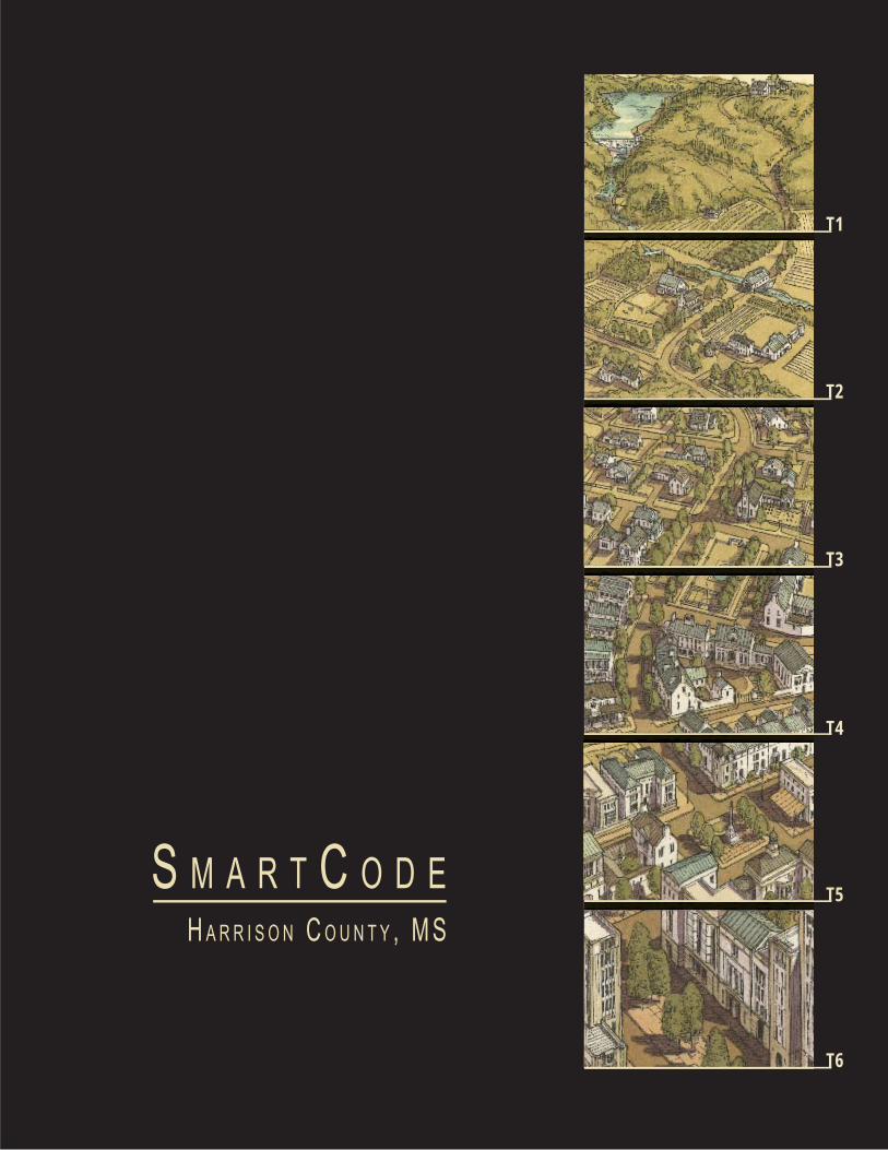
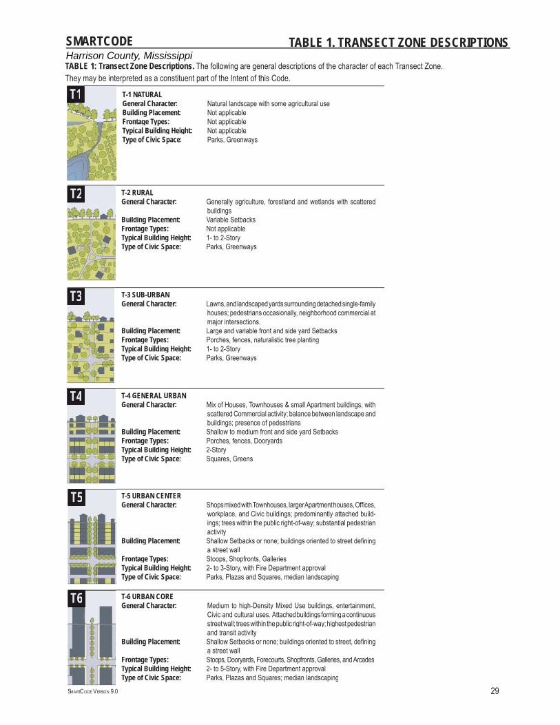
TABLE 1. TRANSECT ZONE DESCRIPTIONS
T1
T2
T3
T4
T5
T6 T-6 URBAN COREGeneral Character: Medium to high-Density Mixed Use buildings, entertainment,
Civic and cultural uses. Attached buildings forming a continuous street wall; trees within the public right-of-way; highest pedestrian and transit activity
Building Placement: Shallow Setbacks or none; buildings oriented to street, defi ning a street wall
Frontage Types: Stoops, Dooryards, Forecourts, Shopfronts, Galleries, and ArcadesTypical Building Height: 2- to 5-Story, with Fire Department approval Type of Civic Space: Parks, Plazas and Squares; median landscaping
T-5 URBAN CENTERGeneral Character: Shops mixed with Townhouses, larger Apartment houses, Offi ces,
workplace, and Civic buildings; predominantly attached build-ings; trees within the public right-of-way; substantial pedestrian activity
Building Placement: Shallow Setbacks or none; buildings oriented to street defi ning a street wall
Frontage Types: Stoops, Shopfronts, GalleriesTypical Building Height: 2- to 3-Story, with Fire Department approval Type of Civic Space: Parks, Plazas and Squares, median landscaping
T-4 GENERAL URBANGeneral Character: Mix of Houses, Townhouses & small Apartment buildings, with
scattered Commercial activity; balance between landscape and buildings; presence of pedestrians
Building Placement: Shallow to medium front and side yard Setbacks Frontage Types: Porches, fences, Dooryards Typical Building Height: 2-Story Type of Civic Space: Squares, Greens
T-3 SUB-URBAN General Character: Lawns, and landscaped yards surrounding detached single-family
houses; pedestrians occasionally, neighborhood commercial at major intersections.
Building Placement: Large and variable front and side yard SetbacksFrontage Types: Porches, fences, naturalistic tree planting Typical Building Height: 1- to 2-StoryType of Civic Space: Parks, Greenways
T-2 RURALGeneral Character: Generally agriculture, forestland and wetlands with scattered
buildingsBuilding Placement: Variable Setbacks Frontage Types: Not applicable Typical Building Height: 1- to 2-Story Type of Civic Space: Parks, Greenways
T-1 NATURAL General Character: Natural landscape with some agricultural use Building Placement: Not applicable Frontage Types: Not applicable Typical Building Height: Not applicable Type of Civic Space: Parks, Greenways
T3
TT1
T2
T4
T5
T6
TABLE 1: Transect Zone Descriptions. The following are general descriptions of the character of each Transect Zone. They may be interpreted as a constituent part of the Intent of this Code.
Harrison County, MississippiSMARTCODE
SMARTCODE VERSION 9.0 30
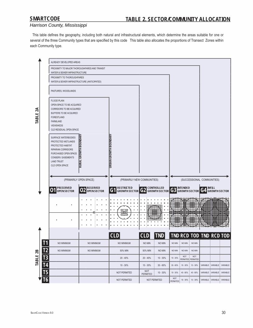
TABLE 2. SECTOR/COMMUNITY ALLOCATION
TABL
E 2A
ALREADY DEVELOPED AREAS
PROXIMITY TO MAJOR THOROUGHFARES AND TRANSITWATER & SEWER INFRASTRUCTURE
PROXIMITY TO THOROUGHFARES WATER & SEWER INFRASTRUCTURE (ANTICIPATED)
PASTURES, WOODLANDS
FLOOD PLAINOPEN SPACE TO BE ACQUIREDCORRIDORS TO BE ACQUIREDBUFFERS TO BE ACQUIREDFORESTLANDFARMLANDVIEWSHEDSCLD RESIDUAL OPEN SPACE
SURFACE WATERBODIESPROTECTED WETLANDSPROTECTED HABITATRIPARIAN CORRIDORSPURCHASED OPEN SPACECONSERV. EASEMENTSLAND TRUSTCLD OPEN SPACE RU
RAL
GROW
TH B
OUND
ARY
URBA
N GR
OWTH
BOU
NDAR
Y
◄ ---------------------------------------------------------------------------------------------------------------------------------------------------------------------------------------------------------------------------------------------------------------------------------------------------------------------------------------------------------------------- ►◄ ------------------------------------------------------------------------------------------------------------------------------------------------------------------------------------------------------------------------------------------------------------------------------------------------------------------------------------------------------------------------ ►◄ --------------------------------------------------------------------------------------------------------------------------------------------------------------------------------------------------------------------------------------------------------------------------------------------------------------------------------------------------------------------------- ►(PRIMARILY OPEN SPACE) (PRIMARILY NEW COMMUNITIES) (SUCCESSIONAL COMMUNITIES)
O1 PRESERVEDOPEN SECTOR O2 RESERVED
OPEN SECTOR G1 RESTRICTEDGROWTH SECTOR G2 CONTROLLED
GROWTH SECTOR G3 INTENDEDGROWTH SECTOR G4 INFILL
GROWTH SECTOR
TABL
E 2B
CLD TND RCD TOD TND RCD TODT1 NO MINIMUM NO MINIMUM NO MINIMUM NO MIN NO MIN NO MIN NO MIN NO MIN
T2 NO MINIMUM NO MINIMUM 50% MIN 50% MIN NO MIN NO MIN NO MIN NO MIN
T3 20 - 40% 20 - 40% 10 - 30% 10 - 30%NOT
PERMITEDNOT
PERMITED
T4 10 - 30% 10 - 30% 30 - 60% 30 - 60% 10 - 30% 10 - 30% VARIABLE VARIABLE VARIABLE
T5 NOT PERMITED NOT PERMITED 10 - 30% 10 - 30% 40 - 80% 40 - 80% VARIABLE VARIABLE VARIABLE
T6 NOT PERMITED NOT PERMITED NOT PERMITED
10 - 30% 10 - 30% VARIABLE VARIABLE VARIABLE
CLD TND
▼
▼
▼
▼
This table defi nes the geography, including both natural and infrastructural elements, which determine the areas suitable for one or several of the three Community types that are specifi ed by this code This table also allocates the proportions of Transect Zones within each Community type.
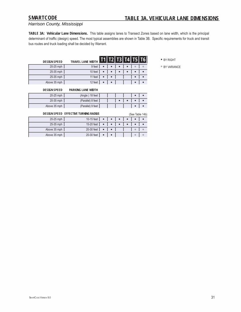
Harrison County, MississippiSMARTCODE
SMARTCODE VERSION 9.0 31
TABLE 3A. VEHICULAR LANE DIMENSIONS
DESIGN SPEED TRAVEL LANE WIDTH T1 T2 T3 T4 T5 T6 ▪ BY RIGHT
20-25 mph 9 feet ▪ ▪ ▪ ▪ ▫ ▫ ▫ BY VARIANCE25-35 mph 10 feet ▪ ▪ ▪ ▪ ▪ ▪25-35 mph 11 feet ▪ ▪ ▪ ▪
Above 35 mph 12 feet ▪ ▪ ▪ ▪DESIGN SPEED PARKING LANE WIDTH
20-25 mph (Angle ) 18 feet ▪ ▪20-35 mph (Parallel) 8 feet ▪ ▪ ▪ ▪
Above 35 mph (Parallel) 9 feet ▪ ▪DESIGN SPEED EFFECTIVE TURNING RADIUS (See Table 14b)
20-25 mph 10-15 feet ▪ ▪ ▪ ▪ ▪ ▪25-35 mph 15-20 feet ▪ ▪ ▪ ▪ ▪ ▪
Above 35 mph 20-30 feet ▪ ▪ ▫ ▫Above 35 mph 20-30 feet ▪ ▪ ▫ ▫
TABLE 3A: Vehicular Lane Dimensions. This table assigns lanes to Transect Zones based on lane width, which is the principal determinant of traffi c (design) speed. The most typical assemblies are shown in Table 3B. Specifi c requirements for truck and transit bus routes and truck loading shall be decided by Warrant.
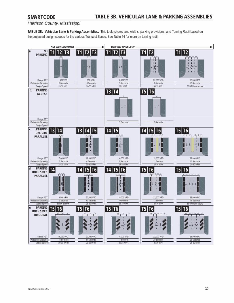
Harrison County, MississippiSMARTCODE
SMARTCODE VERSION 9.0 32
TABLE 3B. VEHICULAR LANE & PARKING ASSEMBLIES
ONE WAY MOVEMENT TWO WAY MOVEMENTa. NO
PARKING T1 T2 T3 T1 T2 T3 T1 T2 T3 T1 T2 T1 T2
Design ADT--------------------------------------------------------------------------------------------------------------------------------------------------------------------------------------------------------------------------------------------------------------------------------------------------------------------------------------------------------------------------------------------------------------------------------------------------------------------------------Pedestrian Crossing----------------------------------------------------------------------------------------------------------------------------------------------------------------------------------------------------------------------------------------Design Speed
300 VPD --------------------------------------------------------------------------------------------------------------------------------------------------------------------------------------------------------------------------------------------------------------------------------------------------------------------------------- 3 Seconds--------------------------------------------------------------------------------------------------------------------------------------------------------------------------------------------------------------------------------------------------------------------------------------------------------------------------------- 20-30 MPH
600 VPD---------------------------------------------------------------------------------------------------------------------------------------------------------------------------------------------------------------------------------------------------------------------------------------------------------------------------------- 5 Seconds---------------------------------------------------------------------------------------------------------------------------------------------------------------------------------------------------------------------------------------------------------------------------------------------------------------------------------- 20-30 MPH
2,500 VPD-------------------------------------------------------------------------------------------------------------------------------------------------------------------------------------------------------------------------------------------------------------------------------------------------------------------------------------------------------------------------------------------------------------------------------- 5 Seconds---------------------------------------------------------------------------------------------------------------------------------------------------------------------------------------------------------------------------------------------------------------------------------------------------------------------------------------------------------------------------------------------------------------------------------- 20-25 MPH
22,000 VPD-------------------------------------------------------------------------------------------------------------------------------------------------------------------------------------------------------------------------------------------------------------------------------------------------------------------------------------------------------------------------------------------------------------------------- 9 Seconds---------------------------------------------------------------------------------------------------------------------------------------------------------------------------------------------------------------------------------------------------------------------------------------------------------------------------------------------------------------------------------------------------------------------------- 30-35 MPH
36,000 VPD--------------------------------------------------------------------------------------------------------------------------------------------------------------------------------------------------------------------------------------------------------------------------------------------------------------------------------------------------------------------------------------------------------------------------------------------------------------------- 13 Seconds----------------------------------------------------------------------------------------------------------------------------------------------------------------------------------------------------------------------------------------------------------------------------------------------------------------------------------------------------------------------------------------------------------------------------------------------------------------------- 35 MPH and above
b. PARKING ACCESS
T3 T4 T5
Design ADT----------------------------------------------------------------------------------------------------------------------------------------------------------------------------------------------------------------------------------------Pedestrian Crossing----------------------------------------------------------------------------------------------------------------------------------------------------------------------------------------------------------------------------------------Design Speed
-------------------------------------------------------------------------------------------------------------------------------------------------------------------------------------------------------------------------------------------------------------------------------------------------------------------------------------------------------------------------------------------------------------------------------- 5 Seconds---------------------------------------------------------------------------------------------------------------------------------------------------------------------------------------------------------------------------------------------------------------------------------------------------------------------------------------------------------------------------------------------------------------------------------- 6 Seconds--------------------------------------------------------------------------------------------------------------------------------------------------------------------------------------------------------------------------------------------------------------------------------------------------------------------------------------------------------------------------------------------------------------------------
c. PARKINGONE SIDE
PARALLELT3 T4 T3 T4 T5 T4 T5 T4 T5 T6 T5 T6
Design ADT----------------------------------------------------------------------------------------------------------------------------------------------------------------------------------------------------------------------------------------Pedestrian Crossing----------------------------------------------------------------------------------------------------------------------------------------------------------------------------------------------------------------------------------------Design Speed
5,000 VPD --------------------------------------------------------------------------------------------------------------------------------------------------------------------------------------------------------------------------------------------------------------------------------------------------------------------------------- 5 Seconds--------------------------------------------------------------------------------------------------------------------------------------------------------------------------------------------------------------------------------------------------------------------------------------------------------------------------------- 20-30 MPH
18,000 VPD---------------------------------------------------------------------------------------------------------------------------------------------------------------------------------------------------------------------------------------------------------------------------------------------------------------------------------- 8 Seconds---------------------------------------------------------------------------------------------------------------------------------------------------------------------------------------------------------------------------------------------------------------------------------------------------------------------------------- 25-30 MPH
16,000 VPD-------------------------------------------------------------------------------------------------------------------------------------------------------------------------------------------------------------------------------------------------------------------------------------------------------------------------------------------------------------------------------------------------------------------------------- 8 Seconds---------------------------------------------------------------------------------------------------------------------------------------------------------------------------------------------------------------------------------------------------------------------------------------------------------------------------------------------------------------------------------------------------------------------------------- 25-30 MPH
15,000 VPD-------------------------------------------------------------------------------------------------------------------------------------------------------------------------------------------------------------------------------------------------------------------------------------------------------------------------------------------------------------------------------------------------------------------------- 11 Seconds---------------------------------------------------------------------------------------------------------------------------------------------------------------------------------------------------------------------------------------------------------------------------------------------------------------------------------------------------------------------------------------------------------------------------- 25-30 MPH
32,000 VPD--------------------------------------------------------------------------------------------------------------------------------------------------------------------------------------------------------------------------------------------------------------------------------------------------------------------------------------------------------------------------------------------------------------------------------------------------------------------- 13 Seconds----------------------------------------------------------------------------------------------------------------------------------------------------------------------------------------------------------------------------------------------------------------------------------------------------------------------------------------------------------------------------------------------------------------------------------------------------------------------- 25-30 MPH
d. PARKING BOTH SIDES
PARALLELT4 T4 T5 T6 T4 T5 T6 T5 T6 T5 T6
Design ADT----------------------------------------------------------------------------------------------------------------------------------------------------------------------------------------------------------------------------------------Pedestrian Crossing----------------------------------------------------------------------------------------------------------------------------------------------------------------------------------------------------------------------------------------Design Speed
8,000 VPD --------------------------------------------------------------------------------------------------------------------------------------------------------------------------------------------------------------------------------------------------------------------------------------------------------------------------------- 7 Seconds--------------------------------------------------------------------------------------------------------------------------------------------------------------------------------------------------------------------------------------------------------------------------------------------------------------------------------- Below 20 MPH
20,000 VPD---------------------------------------------------------------------------------------------------------------------------------------------------------------------------------------------------------------------------------------------------------------------------------------------------------------------------------- 10 Seconds---------------------------------------------------------------------------------------------------------------------------------------------------------------------------------------------------------------------------------------------------------------------------------------------------------------------------------- 25-30 MPH
15,000 VPD-------------------------------------------------------------------------------------------------------------------------------------------------------------------------------------------------------------------------------------------------------------------------------------------------------------------------------------------------------------------------------------------------------------------------------- 10 Seconds---------------------------------------------------------------------------------------------------------------------------------------------------------------------------------------------------------------------------------------------------------------------------------------------------------------------------------------------------------------------------------------------------------------------------------- 25-30 MPH
22,000 VPD-------------------------------------------------------------------------------------------------------------------------------------------------------------------------------------------------------------------------------------------------------------------------------------------------------------------------------------------------------------------------------------------------------------------------- 13 Seconds---------------------------------------------------------------------------------------------------------------------------------------------------------------------------------------------------------------------------------------------------------------------------------------------------------------------------------------------------------------------------------------------------------------------------- 25-30 MPH
32,000 VPD--------------------------------------------------------------------------------------------------------------------------------------------------------------------------------------------------------------------------------------------------------------------------------------------------------------------------------------------------------------------------------------------------------------------------------------------------------------------- 15 Seconds----------------------------------------------------------------------------------------------------------------------------------------------------------------------------------------------------------------------------------------------------------------------------------------------------------------------------------------------------------------------------------------------------------------------------------------------------------------------- 35 MPH and above
e. PARKING BOTH SIDES
DIAGONALT5 T6 T5 T6 T5 T6 T5 T6 T5 T6
Design ADT----------------------------------------------------------------------------------------------------------------------------------------------------------------------------------------------------------------------------------------Pedestrian Crossing----------------------------------------------------------------------------------------------------------------------------------------------------------------------------------------------------------------------------------------Design Speed
18,000 VPD --------------------------------------------------------------------------------------------------------------------------------------------------------------------------------------------------------------------------------------------------------------------------------------------------------------------------------- 15 Seconds--------------------------------------------------------------------------------------------------------------------------------------------------------------------------------------------------------------------------------------------------------------------------------------------------------------------------------- 20-30 MPH
20,000 VPD---------------------------------------------------------------------------------------------------------------------------------------------------------------------------------------------------------------------------------------------------------------------------------------------------------------------------------- 17 Seconds---------------------------------------------------------------------------------------------------------------------------------------------------------------------------------------------------------------------------------------------------------------------------------------------------------------------------------- 20-25 MPH
15,000 VPD-------------------------------------------------------------------------------------------------------------------------------------------------------------------------------------------------------------------------------------------------------------------------------------------------------------------------------------------------------------------------------------------------------------------------------- 17 Seconds---------------------------------------------------------------------------------------------------------------------------------------------------------------------------------------------------------------------------------------------------------------------------------------------------------------------------------------------------------------------------------------------------------------------------------- 20-25 MPH
22,000 VPD-------------------------------------------------------------------------------------------------------------------------------------------------------------------------------------------------------------------------------------------------------------------------------------------------------------------------------------------------------------------------------------------------------------------------- 20 Seconds---------------------------------------------------------------------------------------------------------------------------------------------------------------------------------------------------------------------------------------------------------------------------------------------------------------------------------------------------------------------------------------------------------------------------- 25-30 MPH
31,000 VPD--------------------------------------------------------------------------------------------------------------------------------------------------------------------------------------------------------------------------------------------------------------------------------------------------------------------------------------------------------------------------------------------------------------------------------------------------------------------- 23 Seconds----------------------------------------------------------------------------------------------------------------------------------------------------------------------------------------------------------------------------------------------------------------------------------------------------------------------------------------------------------------------------------------------------------------------------------------------------------------------- 25-30 MPH
T6
TABLE 3B: Vehicular Lane & Parking Assemblies. This table shows lane widths, parking provisions, and Turning Radii based on the projected design speeds for the various Transect Zones. See Table 14 for more on turning radii.
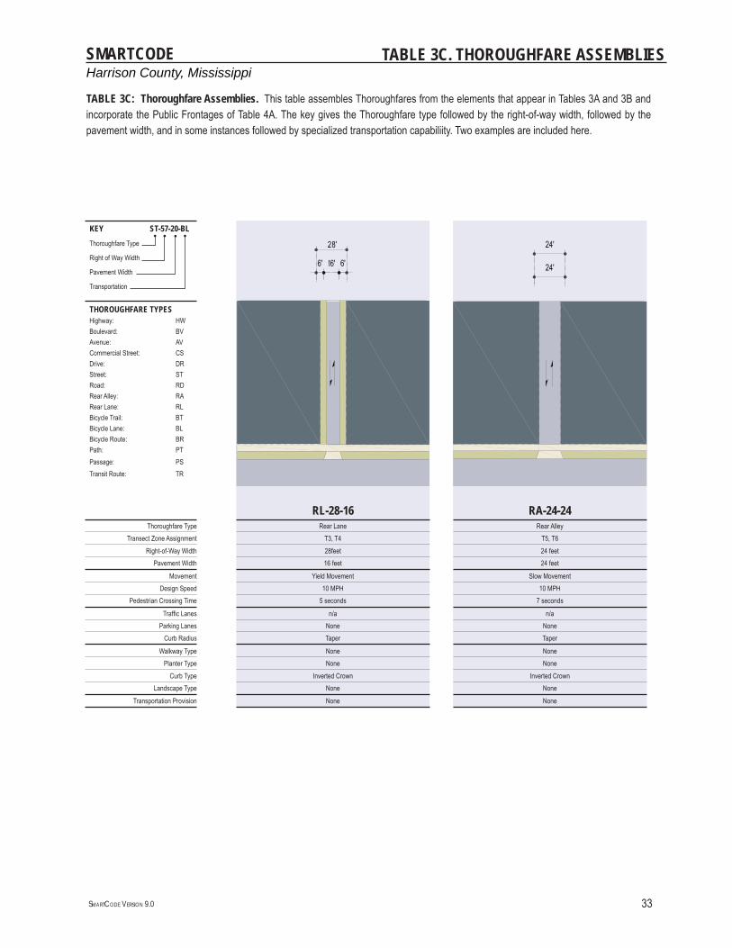
Harrison County, MississippiSMARTCODE
SMARTCODE VERSION 9.0 33
TABLE 3C. THOROUGHFARE ASSEMBLIES
KEY ST-57-20-BLThoroughfare Type
Right of Way Width
Pavement Width
Transportation
THOROUGHFARE TYPESHighway: HWBoulevard: BVAvenue: AVCommercial Street: CSDrive: DRStreet: STRoad: RDRear Alley: RARear Lane: RLBicycle Trail: BTBicycle Lane: BLBicycle Route: BRPath: PTPassage: PSTransit Route: TR
RL-28-16 RA-24-24Thoroughfare Type Rear Lane Rear Alley
Transect Zone Assignment T3, T4 T5, T6Right-of-Way Width 28feet 24 feet
Pavement Width 16 feet 24 feet
Movement Yield Movement Slow MovementDesign Speed 10 MPH 10 MPH
Pedestrian Crossing Time 5 seconds 7 seconds
Traffi c Lanes n/a n/aParking Lanes None None
Curb Radius Taper Taper
Walkway Type None NonePlanter Type None None
Curb Type Inverted Crown Inverted CrownLandscape Type None None
Transportation Provision None None
TABLE 3C: Thoroughfare Assemblies. This table assembles Thoroughfares from the elements that appear in Tables 3A and 3B and incorporate the Public Frontages of Table 4A. The key gives the Thoroughfare type followed by the right-of-way width, followed by the pavement width, and in some instances followed by specialized transportation capabiliity. Two examples are included here.
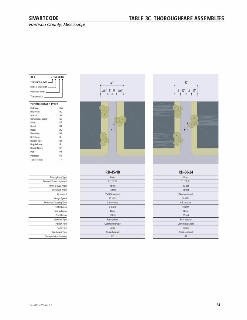
Harrison County, MississippiSMARTCODE
SMARTCODE VERSION 9.0 34
KEY ST-57-20-BLThoroughfare Type
Right of Way Width
Pavement Width
Transportation
THOROUGHFARE TYPESHighway: HWBoulevard: BVAvenue: AVCommercial Street: CSDrive: DRStreet: STRoad: RDRear Alley: RARear Lane: RLBicycle Trail: BTBicycle Lane: BLBicycle Route: BRPath: PTPassage: PSTransit Route: TR
RD-45-18 RD-50-24Thoroughfare Type Road Road
Transect Zone Assignment T1, T2, T3 T1, T2, T3Right-of-Way Width 45feet 50 feet
Pavement Width 18 feet 24 feet
Movement Yield Movement Slow MovementDesign Speed 15 MPH 20 MPH
Pedestrian Crossing Time 5.1 seconds 6.8 seconds
Traffi c Lanes 2 lanes 2 lanesParking Lanes None None
Curb Radius 25 feet 25 feet
Walkway Type Path optional Path optionalPlanter Type Continuous Swale Continuous Swale
Curb Type Swale Swale Landscape Type Trees clustered Trees clustered
Transportation Provision BT BT
TABLE 3C. THOROUGHFARE ASSEMBLIES
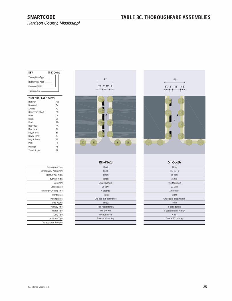
Harrison County, MississippiSMARTCODE
SMARTCODE VERSION 9.0 35
TABLE 3C. THOROUGHFARE ASSEMBLIES
KEY ST-57-20-BLThoroughfare Type
Right of Way Width
Pavement Width
Transportation
THOROUGHFARE TYPESHighway: HWBoulevard: BVAvenue: AVCommercial Street: CSDrive: DRStreet: STRoad: RDRear Alley: RARear Lane: RLBicycle Trail: BTBicycle Lane: BLBicycle Route: BRPath: PTPassage: PSTransit Route: TR
RD-41-20 ST-50-26Thoroughfare Type Road Street
Transect Zone Assignment T5, T6 T4, T5, T6Right-of-Way Width 41 feet 50 feet
Pavement Width 20 feet 26 feet
Movement Slow Movement Free MovementDesign Speed 20 MPH 20 MPH
Pedestrian Crossing Time 6 seconds 7.4 seconds
Traffi c Lanes 1 lanes 2 laneParking Lanes One side @ 8 feet marked One side @ 8 feet marked
Curb Radius 15 feet 10 feet
Walkway Type 13/8 Foot Sidewalk 5 foot SidewalkPlanter Type 4x4" tree well 7 foot continuous Planter
Curb Type Mountable Curb CurbLandscape Type Trees at 30" o.c. Avg Trees at 30' o.c. Avg.
Transportation Provision

Harrison County, MississippiSMARTCODE
SMARTCODE VERSION 9.0 36
TABLE 3C. THOROUGHFARE ASSEMBLIES
KEY ST-57-20-BLThoroughfare Type
Right of Way Width
Pavement Width
Transportation
THOROUGHFARE TYPESHighway: HWBoulevard: BVAvenue: AVCommercial Street: CSDrive: DRStreet: STRoad: RDRear Alley: RARear Lane: RLBicycle Trail: BTBicycle Lane: BLBicycle Route: BRPath: PTPassage: PSTransit Route: TR
ST-58-34 ST-54-34Thoroughfare Type Street Street
Transect Zone Assignment T4, T5, T6 T3, T4Right-of-Way Width 58 feet 54 feet
Pavement Width 34 feet 34 feet
Movement Yield Movement Slow MovementDesign Speed 20 MPH 20 MPH
Pedestrian Crossing Time 9.6 seconds 9.6 seconds
Traffi c Lanes 2 lanes 2 laneParking Lanes Both sides @ 8 feet unmarked Both sides @ 8 feet unmarked
Curb Radius 10 feet 10 feet
Walkway Type 5 foot Sidewalk 5 foot SidewalkPlanter Type 6 foot continuous Planter 5 foot continuous Planter
Curb Type Mountable Curb Mountable CurbLandscape Type Trees at 30' o.c. Avg. Trees at 30' o.c. Avg.
Transportation Provision

Harrison County, MississippiSMARTCODE
SMARTCODE VERSION 9.0 37
TABLE 3C. THOROUGHFARE ASSEMBLIES
KEY ST-57-20-BLThoroughfare Type
Right of Way Width
Pavement Width
Transportation
THOROUGHFARE TYPESHighway: HWBoulevard: BVAvenue: AVCommercial Street: CSDrive: DRStreet: STRoad: RDRear Alley: RARear Lane: RLBicycle Trail: BTBicycle Lane: BLBicycle Route: BRPath: PTPassage: PSTransit Route: TR
ST-62-36 CS-50-22Thoroughfare Type Street Commercial Street
Transect Zone Assignment T3, T4, T5 T5, T6Right-of-Way Width 62 feet 50 feet
Pavement Width 36 feet 22 feet
Movement Slow Movement Slow MovementDesign Speed 20 MPH 20 MPH
Pedestrian Crossing Time 10.2 seconds 6.2 seconds
Traffi c Lanes 2 lanes 1 lanesParking Lanes Both sides @ 8 feet marked One Side @ 8 feet marked
Curb Radius 15 feet 15 feet
Walkway Type 6 foot Sidewalk 18/10 foot SidewalkPlanter Type 7 foot continuous Planter 4x4 foot tree well
Curb Type Mountable Curb Mountable CurbLandscape Type Trees at 30' o.c. Avg. Trees at 30' o.c. Avg.
Transportation Provision BR
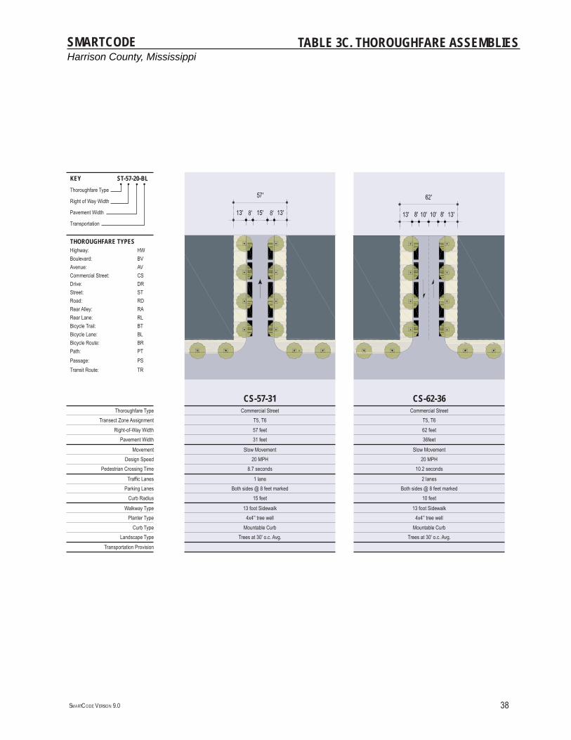
Harrison County, MississippiSMARTCODE
SMARTCODE VERSION 9.0 38
TABLE 3C. THOROUGHFARE ASSEMBLIES
KEY ST-57-20-BLThoroughfare Type
Right of Way Width
Pavement Width
Transportation
THOROUGHFARE TYPESHighway: HWBoulevard: BVAvenue: AVCommercial Street: CSDrive: DRStreet: STRoad: RDRear Alley: RARear Lane: RLBicycle Trail: BTBicycle Lane: BLBicycle Route: BRPath: PTPassage: PSTransit Route: TR
CS-57-31 CS-62-36Thoroughfare Type Commercial Street Commercial Street
Transect Zone Assignment T5, T6 T5, T6Right-of-Way Width 57 feet 62 feet
Pavement Width 31 feet 36feet
Movement Slow Movement Slow MovementDesign Speed 20 MPH 20 MPH
Pedestrian Crossing Time 8.7 seconds 10.2 seconds
Traffi c Lanes 1 lane 2 lanesParking Lanes Both sides @ 8 feet marked Both sides @ 8 feet marked
Curb Radius 15 feet 10 feet
Walkway Type 13 foot Sidewalk 13 foot SidewalkPlanter Type 4x4’' tree well 4x4’' tree well
Curb Type Mountable Curb Mountable CurbLandscape Type Trees at 30' o.c. Avg. Trees at 30' o.c. Avg.
Transportation Provision
Harrison County, MississippiSMARTCODE
SMARTCODE VERSION 9.0 39
TABLE 3C. THOROUGHFARE ASSEMBLIES
KEY ST-57-20-BLThoroughfare Type
Right of Way Width
Pavement Width
Transportation
THOROUGHFARE TYPESHighway: HWBoulevard: BVAvenue: AVCommercial Street: CSDrive: DRStreet: STRoad: RDRear Alley: RARear Lane: RLBicycle Trail: BTBicycle Lane: BLBicycle Route: BRPath: PTPassage: PSTransit Route: TR
CS-80-44 CS-80-54Thoroughfare Type Commercial Street Commercial Street
Transect Zone Assignment T5, T6 T5, T6Right-of-Way Width 80 feet 80 feet
Pavement Width 44 feet 54 feet
Movement Free Movement Slow MovementDesign Speed 25 MPH 25 MPH
Pedestrian Crossing Time 8 seconds at corners 5.7 seconds at corners
Traffi c Lanes 2 lanes 2 lanesParking Lanes Both sides @ 8 feet marked Both sides angled @ 17 feet marked
Curb Radius 10 feet 10 feet
Walkway Type 18 foot Sidewalk 13 foot SidewalkPlanter Type 4x4' tree well 4x4' tree well
Curb Type Mountable Curb Mountable CurbLandscape Type Trees at 30' o.c. Avg. Trees at 30' o.c. Avg.
Transportation Provision
Harrison County, MississippiSMARTCODE
SMARTCODE VERSION 9.0 40
TABLE 3C. THOROUGHFARE ASSEMBLIES
KEY ST-57-20-BLThoroughfare Type
Right of Way Width
Pavement Width
Transportation
THOROUGHFARE TYPESHighway: HWBoulevard: BVAvenue: AVCommercial Street: CSDrive: DRStreet: STRoad: RDRear Alley: RARear Lane: RLBicycle Trail: BTBicycle Lane: BLBicycle Route: BRPath: PTPassage: PSTransit Route: TR
CS-100-64 AV-75-40Thoroughfare Type Commercial Street Avenue
Transect Zone Assignment T5, T6 T3,T4,T5Right-of-Way Width 100 feet 75 feet
Pavement Width 64 feet 40 feet total
Movement Slow Movement Slow MovementDesign Speed 25 MPH 25 MPH
Pedestrian Crossing Time 8.5 seconds at corners 5.7 seconds-5.7 seconds
Traffi c Lanes 2 lanes 2 lanesParking Lanes Both sides angled @ 17 feet marked Both sides @ 8 feet marked
Curb Radius 10 feet 10 feet
Walkway Type 18 foot Sidewalk 6 foot SidewalkPlanter Type 4X4’ tree well 7 foot continuous planter
Curb Type Mountable Curb Mountable Curb or SwaleLandscape Type Trees at 30' o.c. Avg. Trees at 30' o.c. Avg.
Transportation Provision BR, TR
Harrison County, MississippiSMARTCODE
SMARTCODE VERSION 9.0 41
KEY ST-57-20-BLThoroughfare Type
Right of Way Width
Pavement Width
Transportation
THOROUGHFARE TYPESHighway: HWBoulevard: BVAvenue: AVCommercial Street: CSDrive: DRStreet: STRoad: RDRear Alley: RARear Lane: RLBicycle Trail: BTBicycle Lane: BLBicycle Route: BRPath: PTPassage: PSTransit Route: TR
AV-90-56 BV-125-33Thoroughfare Type Avenue Boulevard
Transect Zone Assignment T3, T4, T5 T5,T6Right-of-Way Width 90 feet 115 feet
Pavement Width 56 feet total 20 feet - 33 feet - 20 feet
Movement Slow Movement Free Movement (inner lanes)Design Speed 25 MPH 35 MPH
Pedestrian Crossing Time 5.7 seconds - 5.7 seconds at corners 5.7 seconds - 9.4 seconds - 5.7 seconds
Traffi c Lanes 4 lanes 3 lanes, one turning lane & two one-way slip roadsParking Lanes Both sides @ 8 feet marked 8 feet
Curb Radius 10 feet 10 feet
Walkway Type 6 foot Sidewalk 6 foot SidewalkPlanter Type 7 foot continuous Planter 7 foot continuous Planter
Curb Type Mountable Curb or Swale Mountable Curb or Swale Landscape Type Trees at 30' o.c. Avg. Trees at 30' o.c. Avg.
Transportation Provision BR, TR BR, TR
TABLE 3C. THOROUGHFARE ASSEMBLIES
Harrison County, MississippiSMARTCODE
SMARTCODE VERSION 9.0 42
TABLE 4A. PUBLIC FRONTAGES - GENERAL
PLANLOT
PRIVATE FRONTAGE ►►
◄◄
R.O.W.PUBLIC FRONTAGE
a. (HW) For Highway: This Frontage has open Swales drained by percolation, Bicycle Trails and no parking. The landscaping consists of the natural condition or multiple species arrayed in naturalistic clusters. Buildings are buffered by distance or berms.
T1T2T3
b. (RD) For Road: This Frontage has open Swales drained by percolation and a walk-ing Path or Bicycle Trail along one or both sides and Yield parking. The landscaping consists of multiple species arrayed in naturalistic clusters.
T1T2T3
c. (ST) For Street: This Frontage has raised Curbs drained by inlets and Sidewalks separated from the vehicular lanes by individual or continuous Planters, with parking on one or both sides. The landscaping consists of street trees of a single or alternating species aligned in a regularly spaced Allee, with the exception that Streets with a right-of-way (R.O.W.) width of 40 feet or less are exempt from tree requirements.
T3T4T5
d. (DR) For Drive: This Frontage has raised Curbs drained by inlets and a wide Sidewalk or paved Path along one side, related to a Greenway or waterfront. It is separated from the vehicular lanes by individual or continuous Planters. The landscaping consists of street trees of a single or alternating species aligned in a regularly spaced Allee.
T3T4T5T6
e. (AV) For Avenue: This Frontage has raised Curbs drained by inlets and wide Sidewalks separated from the vehicular lanes by a narrow continuous Planter with parking on both sides. The landscaping consists of a single tree species aligned in a regularly spaced Allee.
T3T4T5T6
f. (CS) (AV) For Commercial Street or Avenue: This Frontage has raised Curbs drained by inlets and very wide Sidewalks along both sides separated from the vehicular lanes by separate tree wells with grates and parking on both sides. The landscaping consists of a single tree species aligned with regular spacing where possible, but clears the storefront entrances.
T5T6
g. (BV) For Boulevard: This Frontage has Slip Roads on both sides. It consists of raised Curbs drained by inlets and Sidewalks along both sides, separated from the vehicular lanes by Planters. The landscaping consists of double rows of a single tree species aligned in a regularly spaced Allee.
T3T4T5T6
TABLE 4A: Public Frontages - General. The Public Frontage is the area between the private Lot line and the edge of the vehicular lanes. Dimensions are given in Table 4B.
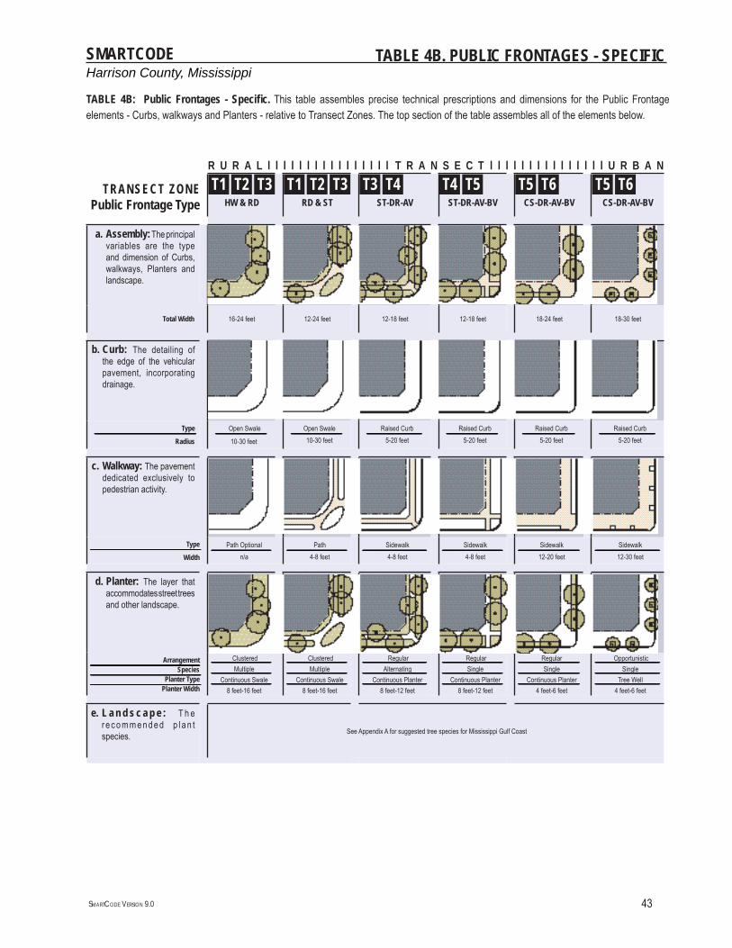
Harrison County, MississippiSMARTCODE
SMARTCODE VERSION 9.0 43
TABLE 4B. PUBLIC FRONTAGES - SPECIFIC
R U R A L l l l l l l l l l l l l l l l l T R A N S E C T l l l l l l l l l l l l l l l U R B A N
TRANSECT ZONEPublic Frontage Type
T1 T2 T3HW & RD
T1 T2 T3RD & ST
T3 T4ST-DR-AV
T4 T5ST-DR-AV-BV
T5 T6CS-DR-AV-BV
T5 T6CS-DR-AV-BV
a. Assembly: The principal variables are the type and dimension of Curbs, walkways, Planters and landscape.
Total Width 16-24 feet 12-24 feet 12-18 feet 12-18 feet 18-24 feet 18-30 feet
b. Curb: The detailing of the edge of the vehicular pavement, incorporating drainage.
Type ------------------------------------------------------------------------------------------------------------------------------------------------------------------------------------------------------------------------------------------------------------------------------------------------------------------------------------------------------------------------------------------------------------------------------------------ Radius
Open Swale--------------------------------------------------------------------------------------------------------------------------------------------------------------------------------------------------------------------- 10-30 feet
Open Swale--------------------------------------------------------------------------------------------------------------------------------------------------------------------------------------------------------------------- 10-30 feetRaised Curb-------------------------------------------------------------------------------------------------------------------------------------------------------------------------------------------------------------------------------------- 5-20 feet
Raised Curb---------------------------------------------------------------------------------------------------------------------------------------------------------------------------------------------------------------------- 5-20 feetRaised Curb-------------------------------------------------------------------------------------------------------------------------------------------------------------------------------------------------------------------------- 5-20 feet
Raised Curb----------------------------------------------------------------------------------------------------------------------------------------------------------------------------------------------------------------------------------------- 5-20 feet
c. Walkway: The pavement dedicated exclusively to pedestrian activity.
Type -------------------------------------------------------------------------------------------------------------------------------------------------------------------------------------------------------------------------------------------------------------------------------------------------------------------------------------------------------------------------------------------------------------------------------------------------------------------------------- Width
Path Optional---------------------------------------------------------------------------------------------------------------------------------------------------------------------------------------------------------------------------------------------------------- n/aPath----------------------------------------------------------------------------------------------------------------------------------------------------------------------------------------------------------------------------------------------------------- 4-8 feet
Sidewalk---------------------------------------------------------------------------------------------------------------------------------------------------------------------------------------------------------------------------------------------------------------------------- 4-8 feetSidewalk------------------------------------------------------------------------------------------------------------------------------------------------------------------------------------------------------------------------------------------------------------ 4-8 feet
Sidewalk---------------------------------------------------------------------------------------------------------------------------------------------------------------------------------------------------------------------------------------------------------------- 12-20 feetSidewalk------------------------------------------------------------------------------------------------------------------------------------------------------------------------------------------------------------------------------------------------------------------------------- 12-30 feet
d. Planter: The layer that accommodates street trees and other landscape.
Arrangement---------------------------------------------------------------------------------------------------------------------------------------------------------------------------------------------------------------------------------------------------------------------------------------------------------------------------------------------------------------------------------------------------------------------------------------------------------------------------- Species--------------------------------------------------------------------------------------------------------------------------------------------------------------------------------------------------------------------------------------------------------------------------------------------------------------------------------------------------------------------------------------------------------------------------------------------------------------------------------Planter Type--------------------------------------------------------------------------------------------------------------------------------------------------------------------------------------------------------------------------------------------------------------------------------------------------------------------------------------------------------------------------------------------------------------------------------------------------------------------------------Planter Width
Clustered---------------------------------------------------------------------------------------------------------------------------------------------------------------------------------------------------------------------------------------------------------- Multiple----------------------------------------------------------------------------------------------------------------------------------------------------------------------------------------------------------------------------------------------------------Continuous Swale----------------------------------------------------------------------------------------------------------------------------------------------------------------------------------------------------------------------------------------------------------
8 feet-16 feet
Clustered----------------------------------------------------------------------------------------------------------------------------------------------------------------------------------------------------------------------------------------------------------- Multiple-----------------------------------------------------------------------------------------------------------------------------------------------------------------------------------------------------------------------------------------------------------Continuous Swale-----------------------------------------------------------------------------------------------------------------------------------------------------------------------------------------------------------------------------------------------------------
8 feet-16 feet
Regular---------------------------------------------------------------------------------------------------------------------------------------------------------------------------------------------------------------------------------------------------------------------------- Alternating----------------------------------------------------------------------------------------------------------------------------------------------------------------------------------------------------------------------------------------------------------------------------Continuous Planter----------------------------------------------------------------------------------------------------------------------------------------------------------------------------------------------------------------------------------------------------------------------------
8 feet-12 feet
Regular------------------------------------------------------------------------------------------------------------------------------------------------------------------------------------------------------------------------------------------------------------ Single------------------------------------------------------------------------------------------------------------------------------------------------------------------------------------------------------------------------------------------------------------Continuous Planter------------------------------------------------------------------------------------------------------------------------------------------------------------------------------------------------------------------------------------------------------------
8 feet-12 feet
Regular---------------------------------------------------------------------------------------------------------------------------------------------------------------------------------------------------------------------------------------------------------------- Single----------------------------------------------------------------------------------------------------------------------------------------------------------------------------------------------------------------------------------------------------------------Continuous Planter----------------------------------------------------------------------------------------------------------------------------------------------------------------------------------------------------------------------------------------------------------------
4 feet-6 feet
Opportunistic------------------------------------------------------------------------------------------------------------------------------------------------------------------------------------------------------------------------------------------------------------------------------- Single-------------------------------------------------------------------------------------------------------------------------------------------------------------------------------------------------------------------------------------------------------------------------------Tree Well-------------------------------------------------------------------------------------------------------------------------------------------------------------------------------------------------------------------------------------------------------------------------------
4 feet-6 feet
e. L a n d s c a p e : T h e r e c o m m e n d e d p l a n t species. See Appendix A for suggested tree species for Mississippi Gulf Coast
TABLE 4B: Public Frontages - Specifi c. This table assembles precise technical prescriptions and dimensions for the Public Frontage elements - Curbs, walkways and Planters - relative to Transect Zones. The top section of the table assembles all of the elements below.
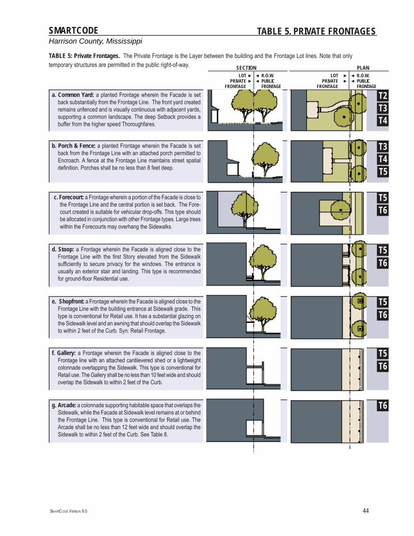
Harrison County, MississippiSMARTCODE
SMARTCODE VERSION 9.0 44
TABLE 5. PRIVATE FRONTAGES
SECTION PLANLOT
PRIVATE FRONTAGE
►►
◄◄
R.O.W.PUBLIC FRONTAGE
LOT PRIVATE
FRONTAGE
►►
◄◄
R.O.W.PUBLIC FRONTAGE
a. Common Yard: a planted Frontage wherein the Facade is set back substantially from the Frontage Line. The front yard created remains unfenced and is visually continuous with adjacent yards, supporting a common landscape. The deep Setback provides a buffer from the higher speed Thoroughfares.
T2T3
b. Porch & Fence: a planted Frontage wherein the Facade is set back from the Frontage Line with an attached porch permitted to Encroach. A fence at the Frontage Line maintains street spatial defi nition. Porches shall be no less than 8 feet deep.
T3T4
c. Forecourt: a Frontage wherein a portion of the Facade is close to the Frontage Line and the central portion is set back. The Fore-court created is suitable for vehicular drop-offs. This type should be allocated in conjunction with other Frontage types. Large trees within the Forecourts may overhang the Sidewalks.
d. Stoop: a Frontage wherein the Facade is aligned close to the Frontage Line with the fi rst Story elevated from the Sidewalk suffi ciently to secure privacy for the windows. The entrance is usually an exterior stair and landing. This type is recommended for ground-fl oor Residential use.
e. Shopfront: a Frontage wherein the Facade is aligned close to the Frontage Line with the building entrance at Sidewalk grade. This type is conventional for Retail use. It has a substantial glazing on the Sidewalk level and an awning that should overlap the Sidewalk to within 2 feet of the Curb. Syn: Retail Frontage.
f. Gallery: a Frontage wherein the Facade is aligned close to the Frontage line with an attached cantilevered shed or a lightweight colonnade overlapping the Sidewalk. This type is conventional for Retail use. The Gallery shall be no less than 10 feet wide and should overlap the Sidewalk to within 2 feet of the Curb.
g. Arcade: a colonnade supporting habitable space that overlaps the Sidewalk, while the Facade at Sidewalk level remains at or behind the Frontage Line. This type is conventional for Retail use. The Arcade shall be no less than 12 feet wide and should overlap the Sidewalk to within 2 feet of the Curb. See Table 8.
T4
T5T6
T5
T6
T6T5
T6T5
T6T5
TABLE 5: Private Frontages. The Private Frontage is the Layer between the building and the Frontage Lot lines. Note that only temporary structures are permitted in the public right-of-way.
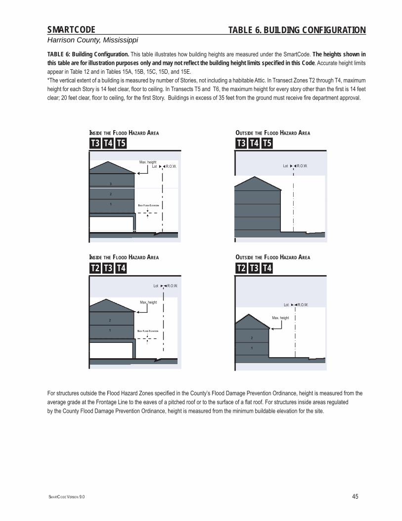
Harrison County, MississippiSMARTCODE
SMARTCODE VERSION 9.0 45
TABLE 6. BUILDING CONFIGURATION
R.O.W.LotR.O.W.Lot
R.O.W.Lot
Max. height
Max. height
BASE FLOOD ELEVATION
3
2
1
3
2
1
Max. height
2
1
R.O.W.Lot
Max. height
2
1
TABLE 6: Building Confi guration. This table illustrates how building heights are measured under the SmartCode. The heights shown in this table are for illustration purposes only and may not refl ect the building height limits specifi ed in this Code. Accurate height limits appear in Table 12 and in Tables 15A, 15B, 15C, 15D, and 15E.*The vertical extent of a building is measured by number of Stories, not including a habitable Attic. In Transect Zones T2 through T4, maximum height for each Story is 14 feet clear, fl oor to ceiling. In Transects T5 and T6, the maximum height for every story other than the fi rst is 14 feet clear; 20 feet clear, fl oor to ceiling, for the fi rst Story. Buildings in excess of 35 feet from the ground must receive fi re department approval.
For structures outside the Flood Hazard Zones specifi ed in the County’s Flood Damage Prevention Ordinance, height is measured from theaverage grade at the Frontage Line to the eaves of a pitched roof or to the surface of a fl at roof. For structures inside areas regulatedby the County Flood Damage Prevention Ordinance, height is measured from the minimum buildable elevation for the site.
INSIDE THE FLOOD HAZARD AREA
INSIDE THE FLOOD HAZARD AREA
OUTSIDE THE FLOOD HAZARD AREA
OUTSIDE THE FLOOD HAZARD AREA
BASE FLOOD ELEVATION
T5T4T3 T5T4T3
T4T3T2 T4T3T2
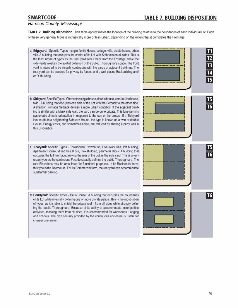
Harrison County, MississippiSMARTCODE
SMARTCODE VERSION 9.0 46
TABLE 7. BUILDING DISPOSITION
a. Edgeyard: Specifi c Types - single family House, cottage, villa, estate house, urban villa. A building that occupies the center of its Lot with Setbacks on all sides. This is the least urban of types as the front yard sets it back from the Frontage, while the side yards weaken the spatial defi nition of the public Thoroughfare space. The front yard is intended to be visually continuous with the yards of adjacent buildings. The rear yard can be secured for privacy by fences and a well-placed Backbuilding and/or Outbuilding.
b. Sideyard: Specifi c Types - Charleston single house, double house, zero-lot-line house, twin. A building that occupies one side of the Lot with the Setback to the other side. A shallow Frontage Setback defi nes a more urban condition. If the adjacent build-ing is similar with a blank side wall, the yard can be quite private. This type permits systematic climatic orientation in response to the sun or the breeze. If a Sideyard House abuts a neighboring Sideyard House, the type is known as a twin or double House. Energy costs, and sometimes noise, are reduced by sharing a party wall in this Disposition.
c. Rearyard: Specifi c Types - Townhouse, Rowhouse, Live-Work unit, loft building, Apartment House, Mixed Use Block, Flex Building, perimeter Block. A building that occupies the full Frontage, leaving the rear of the Lot as the sole yard. This is a very urban type as the continuous Facade steadily defi nes the public Thoroughfare. The rear Elevations may be articulated for functional purposes. In its Residential form, this type is the Rowhouse. For its Commercial form, the rear yard can accommodate substantial parking.
d. Courtyard: Specifi c Types - Patio House. A building that occupies the boundaries of its Lot while internally defi ning one or more private patios. This is the most urban of types, as it is able to shield the private realm from all sides while strongly defi n-ing the public Thoroughfare. Because of its ability to accommodate incompatible activities, masking them from all sides, it is recommended for workshops, Lodging and schools. The high security provided by the continuous enclosure is useful for crime-prone areas.
T5T6
T6
T5T6
T5T4T3T2T1
TABLE 7: Building Disposition. This table approximates the location of the building relative to the boundaries of each individual Lot. Each of these very general types is intrinsically more or less urban, depending on the extent that it completes the Frontage.
Harrison County, MississippiSMARTCODE
SMARTCODE VERSION 9.0 47
TABLE 8. BUILDING FUNCTION
T2 T4 T5 T6a. RESIDENTIAL Restricted Residential: The number of
dwellings on each Lot is restricted to one within a Principal Building and one within an Accessory Building, with 2.0 parking places for each. Both dwellings shall be under single ownership. The habitable area of the Accessory dwelling shall not exceed 500 square feet.
Limited Residential:The number of dwellings on each Lot is limited by the requirement of 2 parking places for each dwelling, a ratio which may be reduced according to the shared parking standards (See Table 11).
Open Residential:The number of dwellings on each Lot is limited by the requirement of 1.5 parking places for each dwelling, a ratio which may be reduced according to the shared parking standards (See Table 11).
b. LODGING Restricted Lodging: The number of bed-rooms available on each Lot for lodging is limited by the requirement of 1.5 assigned parking place for each bedroom, up to fi ve, in addition to the parking requirement for the dwelling. The Lodging must be owner occupied. Food service may be provided in the a.m. The maximum length of stay shall not exceed ten days.
Limited Lodging: The number of bed-rooms available on each Lot for lodging is limited by the requirement of 1.5 assigned parking places for each bedroom, up to twelve, in addition to the parking require-ment for the dwelling. The Lodging must be owner occupied.Food service may be provided in the a.m. The maximum length of stay shall not exceed ten days.
Open Lodging: The number of bedrooms available on each Lot for lodging is limited by the requirement of 1.0 assigned parking places for each bedroom. Food service may be provided at all times. The area allocated for food service shall be calcu-lated and provided with parking according to Retail Function.
c. OFFICE Restricted Offi ce: The building area available for offi ce use on each Lot is restricted to the fi rst Story of the Principal or the Accessory Building and by the requirement of 2.5 assigned parking places per 1000 square feet of net offi ce space in addition to the parking requirement for each dwelling.
Limited Offi ce: The building area available for offi ce use on each Lot is limited to the fi rst Story of the principal building and/or to the Accessory building, and by the requirement of 2.5 assigned parking places per 1000 square feet of net offi ce space in addition to the parking requirement for each dwelling.
Open Offi ce: The building area available for offi ce use on each Lot is limited by the requirement of 2.0 assigned parking places per 1000 square feet of net offi ce space.
d. RETAIL Restricted Retail: The building area avail-able for Retail use is restricted to one Block corner location at the fi rst Story for each 300 dwelling units and by the requirement of 4.0 assigned parking places per 1000 square feet of net Retail space in addition to the parking requirement of each dwelling. The specifi c use shall be further limited to neighborhood store, or food service seating no more than 20.
Limited Retail: The building area available for Retail use is limited to the fi rst Story of buildings at corner locations, not more than one per Block, and by the requirement of 4.0 assigned parking places per 1000 square feet of net Retail space in addition to the parking requirement of each dwelling. The specifi c use shall be further limited to neighborhood store, or food service seating no more than 40.
Open Retail: The building area available for Retail use is limited by the requirement of 3.0 assigned parking places per 1000 square feet of net Retail space. Retail spaces under 1500 square feet are exempt from parking requirements.
e. CIVIC Open Use: The building area available for civic use is open to building design criteria of the developer. Civic uses shall assign 3.0 parking spcaes per 1000 sqare feet.
Open Use: The building area available for civic use is open to building design criteria of the developer. Civic uses shall assign 3.0 parking spcaes per 1000 sqare feet.
Open Use: The building area available for civic use is open to building design criteria of the developer. Civic uses shall assign 2.0 parking spcaes per 1000 sqare feet.
f. OTHER See Table 12 See Table 12 See Table 12
TABLE 8: Building Function - General. This table categorizes as Function the range of uses for which a building is appropriate within each Transect Zone. Parking requirements are correlated to functional intensity. For greater precision prescribing specifi c uses, Table 12 may be used in addition to Table 10.
T3
Harrison County, MississippiSMARTCODE
SMARTCODE VERSION 9.0 48
TABLE 9. PARKING CALCULATIONS
REQUIRED PARKING (See Table 10)
T2 T3 T4 T5 T6RESIDENTIAL 2.0 / dwelling 1.5 / dwelling
LODGING 1.5 / bedroom 1.0 / bedroom
OFFICE 2.5 / 1000 sq. ft. 2.0 / 1000 sq. ft.
RETAIL 4.0 / 1000 sq. ft. 3.0 / 1000 sq. ft.
CIVIC 3.0 / 1000 sq. ft. 2.0 / 1000 sq. ft.
OTHER Refer to section 700 of the Harrison County Zoning Ordinance
TABLE 9b. The Parking Calculation Table is a summary of the parking requirements that appear in Table 11, along with the associated Sharing Factors. There are two ways to use a Shared Parking Factor. 1. Density may be determined by the amount of parking provided. Base Density may be adjusted upward by adding the Actual Parking available for each of two Functions and the sum then multiplied by the corresponding Shared Parking Factor. The result shall be the Effective Parking available for calculating Adjusted Density for both Functions. 2. Conversely: The Effective Parking required for any two Functions whose Density is already determined is the sum of the Required Parking multiplied by the Shared Parking Factor.
SHARING FACTORFUNCTION WITH FUNCTION
RESIDENTIAL RESIDENTIAL
LODGING LODGING
OFFICE OFFICE
RETAIL RETAIL
CIVIC CIVIC
1
1
1
1
1
91%71%
59%77%
83%83%
77%
83%83%
91%
59%91%
91%77%
83%
83% 83%83%
77%
83%
TABLE 9a. Parking Calculations. The Required Parking table summarizes the parking requirements of Table 10 for each site or, conversely, the amount of building allowed on each site given the parking available.
Harrison County, MississippiSMARTCODE
SMARTCODE VERSION 9.0 49
TABLE 10. SPECIFIC FUNCTION & USE
a. RESIDENTIAL T1 T2 T3 T4 T5 T6 SDAccessory Building ▪ ▪ ▪ ▪ ▫Apartment Building ▫ ▪ ▪ ▪ ▫
Cottage ▪ ▪ ▫Duplex Dwelling ▫ ▪ ▪
Dwelling ▪ ▪ ▪Estate House ▪ ▪ ▪ ▪
Live/Work Unit ▪ ▪ ▪ ▪ ▫Row House ▪ ▪ ▪ ▫
Sideyard House ▪ ▪ ▪b. LODGINGBed & Breakfast (up to 5 rooms) ▫ ▫ ▪ ▪ ▪
Bed & Breakfast Inn ▫ ▪ ▪ ▪Hotel ▪ ▪ ▫
c. OFFICEMedical Clinic ▫
Offi ce Building ▪ ▪ ▪ ▫d. RETAIL
Funeral Home ▪ ▪ ▪ ▫Hospital ▪ ▪ ▪ ▫
Kiosk ▪ ▪ ▪ ▫Liquor Selling Establishment ▪ ▪
Movie Theater ▪ ▪ ▪Open-Market Building ▫ ▪ ▪ ▪
Personal/Prof. Services ▪ ▪ ▫Religious Assembly ▫ ▪ ▪ ▪ ▫
Restaurant ▪ ▪ ▪ ▫Retail Building ▪ ▪ ▪ ▫
Shopping Center ▪ ▪ ▫Shopping Mall ▪ ▪ ▫
e. CIVICBus Station ▪ ▪ ▪ ▪ ▫
Convention Center ▪ ▪ ▫Fire Station ▪ ▪ ▪ ▪ ▪
Fountain or Public Art ▪ ▪ ▪ ▪ ▪ ▫
e. CIVIC (CON’T) T1 T2 T3 T4 T5 T6 SDGolf Course ▪ ▪ ▪ ▫
Library ▪ ▪ ▪ ▫Marina ▪ ▪ ▫
Museum ▪ ▪ ▫Outdoor Auditorium ▪ ▪ ▪ ▪ ▫
Park ▪ ▪ ▪ ▪ ▪ ▪ ▪Parking Structure ▪ ▪ ▫
Playground ▪ ▪ ▪ ▪ ▪ ▪ ▪Police Station ▪ ▪ ▪ ▪
Surface Parking Lot ▪ ▪ ▪ ▪f. OTHER: AGRICULTURE
Greenhouse ▫ ▪ ▪ ▫Kennel ▪ ▪ ▫ ▫
Livestock Pen ▫ ▪ ▫Stable ▪ ▫ ▫
f. OTHER: EDUCATIONChildcare Center ▪ ▪ ▪ ▪ ▫
College ▫Elementary School ▪ ▪ ▪ ▪ ▫
High School ▪ ▪ ▪ ▫Trade School ▪ ▪
f. OTHER: INDUSTRIALElectric Substation ▫ ▫ ▫ ▫ ▫ ▫ ▫
Industrial ▪ ▫Mini-Warehouse Storage ▪
Truck Ternimal ▫Warehouse ▪
Waste Facility ▫Water Supply Facility ▫ ▫ ▫
Wireless Comm. Tower ▪ ▪ ▫ ▫ ▫ ▫* Other uses not specifi cally listed shall be interpreted by the Zoning Administrator
▪ BY RIGHT
▫ BY CONDITIONAL USE
TABLE 10: Specifi c Function & Use. This table increases the precision of the Building Function categories of Table 8. Table 10 should be customized for local character and requirements.
Harrison County, MississippiSMARTCODE
SMARTCODE VERSION 9.0 50
TABLE 11. CIVIC SPACE
a. Park: A natural preserve available for unstructured recreation. A park may be inde-pendent of surrounding building Frontages. Its landscape shall consist of Paths and trails, meadows, waterbodies, woodland and open shelters, all naturalistically disposed. Parks may be lineal, following the trajectories of natural corridors. The minimum size shall be 8 acres. Larger parks are allowed as a Special District in all zones.
b. Green: An Open Space, available for unstructured recreation. A Green may be spatially defi ned by landscaping rather than building Frontages. Its landscape shall consist of lawn and trees, naturalistically disposed. The minimum size shall be 1/2 acre and the maximum shall be 8 acres.
c. Square: An Open Space available for unstructured recreation and Civic purposes. A Square is spatially defi ned by building Frontages. Its landscape shall consist of paths, lawns and trees, formally disposed. Squares shall be located at the intersection of important Thoroughfares. The minimum size shall be 1/2 acre and the maximum shall be 5 acres.
d. Plaza: An Open Space available for Civic purposes and Commercial activities. A Plaza shall be spatially defi ned by building Frontages. Its landscape shall consist primarily of pavement. Trees are optional. Plazas should be located at the intersec-tion of important streets. The minimum size shall be 1/2 acre and the maximum shall be 2 acres.
e. Playground: An open space designed and equipped for the recreation of children. A playground shall be fenced and may include an open shelter. Playgrounds shall be interspersed within residential areas and may be placed within a block. Playgrounds may be included within parks and greens. There shall be no minimum or maximum size. A Pocket Park may be substituted anywhere a Playground is required, but is designed for the use of adults, with benches, lighting, trash receptacles, and commonly more elaborate landscaping and use of public art than is typical of other Civic Spaces.
T1T2T3
T5T6
T6
T4T5T6
T3T4T5T6
T1T2T3T4T5T6
TABLE 11: Civic Space. The intended types of Civic Space are diagrammed and described in this Table. The diagrams are only illustrative; specifi c designs would be prepared in accordance to the verbal descriptions on this table.
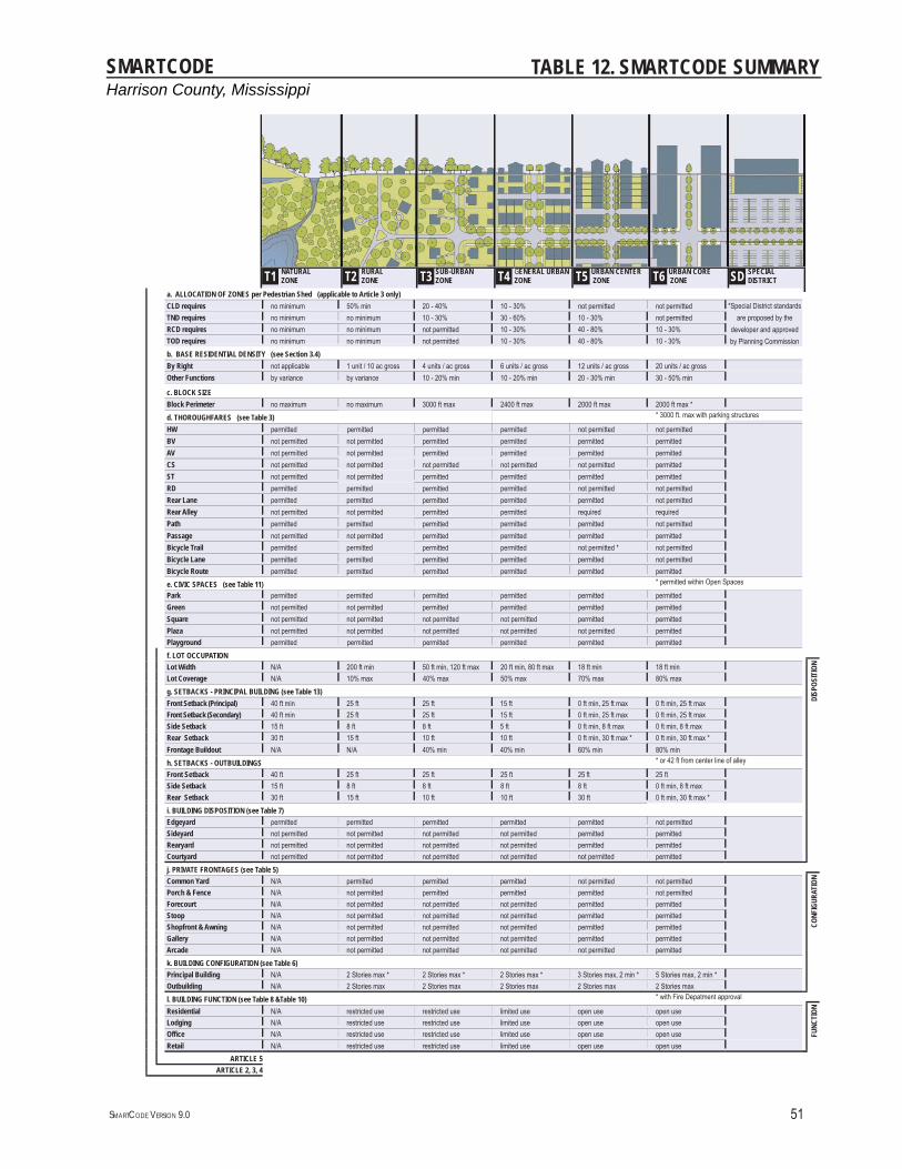
Harrison County, MississippiSMARTCODE
SMARTCODE VERSION 9.0 51
TABLE 12. SMARTCODE SUMMARY
T1 NATURAL ZONE T2
RURAL ZONE T3
SUB-URBANZONE T4
GENERAL URBAN ZONE T5
URBAN CENTER ZONE T6
URBAN CORE ZONE
SD SPECIAL DISTRICT
a. ALLOCATION OF ZONES per Pedestrian Shed (applicable to Article 3 only)CLD requires no minimum 50% min 20 - 40% 10 - 30% not permitted not permittedTND requires no minimum no minimum 10 - 30% 30 - 60% 10 - 30% not permittedRCD requires no minimum no minimum not permitted 10 - 30% 40 - 80% 10 - 30%TOD requires no minimum no minimum not permitted 10 - 30% 40 - 80% 10 - 30%b. BASE RESIDENTIAL DENSITY (see Section 3.4)By Right not applicable 1 unit / 10 ac gross 4 units / ac gross 6 units / ac gross 12 units / ac gross 20 units / ac grossOther Functions by variance by variance 10 - 20% min 10 - 20% min 20 - 30% min 30 - 50% min
c. BLOCK SIZEBlock Perimeter no maximum no maximum 3000 ft max 2400 ft max 2000 ft max 2000 ft max *d. THOROUGHFARES (see Table 3) * 3000 ft. max with parking structures
HW permitted permitted permitted permitted not permitted not permittedBV not permitted not permitted permitted permitted permitted permittedAV not permitted not permitted permitted permitted permitted permittedCS not permitted not permitted not permitted not permitted not permitted permittedST not permitted not permitted permitted permitted permitted permittedRD permitted permitted permitted permitted not permitted not permittedRear Lane permitted permitted permitted permitted permitted not permittedRear Alley not permitted not permitted permitted permitted required requiredPath permitted permitted permitted permitted permitted not permittedPassage not permitted not permitted permitted permitted permitted permittedBicycle Trail permitted permitted permitted permitted not permitted * not permittedBicycle Lane permitted permitted permitted permitted permitted not permittedBicycle Route permitted permitted permitted permitted permitted permittede. CIVIC SPACES (see Table 11) * permitted within Open Spaces
Park permitted permitted permitted permitted permitted permittedGreen not permitted not permitted permitted permitted permitted permittedSquare not permitted not permitted not permitted not permitted permitted permittedPlaza not permitted not permitted not permitted not permitted not permitted permittedPlayground permitted permitted permitted permitted permitted permittedf. LOT OCCUPATIONLot Width N/A 200 ft min 50 ft min, 120 ft max 20 ft min, 80 ft max 18 ft min 18 ft min
DISP
OSIT
ION
Lot Coverage N/A 10% max 40% max 50% max 70% max 80% maxg. SETBACKS - PRINCIPAL BUILDING (see Table 13)Front Setback (Principal) 40 ft min 25 ft 25 ft 15 ft 0 ft min, 25 ft max 0 ft min, 25 ft maxFront Setback (Secondary) 40 ft min 25 ft 25 ft 15 ft 0 ft min, 25 ft max 0 ft min, 25 ft maxSide Setback 15 ft 8 ft 8 ft 5 ft 0 ft min, 8 ft max 0 ft min, 8 ft maxRear Setback 30 ft 15 ft 10 ft 10 ft 0 ft min, 30 ft max * 0 ft min, 30 ft max *Frontage Buildout N/A N/A 40% min 40% min 60% min 80% minh. SETBACKS - OUTBUILDINGS * or 42 ft from center line of alley
Front Setback 40 ft 25 ft 25 ft 25 ft 25 ft 25 ftSide Setback 15 ft 8 ft 8 ft 8 ft 8 ft 0 ft min, 8 ft maxRear Setback 30 ft 15 ft 10 ft 10 ft 30 ft 0 ft min, 30 ft max *i. BUILDING DISPOSITION (see Table 7)Edgeyard permitted permitted permitted permitted permitted not permittedSideyard not permitted not permitted not permitted not permitted permitted permittedRearyard not permitted not permitted not permitted not permitted permitted permittedCourtyard not permitted not permitted not permitted not permitted not permitted permittedj. PRIVATE FRONTAGES (see Table 5)Common Yard N/A permitted permitted permitted not permitted not permitted
CONF
IGUR
ATIO
N
Porch & Fence N/A not permitted permitted permitted permitted not permittedForecourt N/A not permitted not permitted not permitted permitted permittedStoop N/A not permitted not permitted not permitted permitted permittedShopfront & Awning N/A not permitted not permitted not permitted permitted permittedGallery N/A not permitted not permitted not permitted permitted permittedArcade N/A not permitted not permitted not permitted not permitted permittedk. BUILDING CONFIGURATION (see Table 6)Principal Building N/A 2 Stories max * 2 Stories max * 2 Stories max * 3 Stories max, 2 min * 5 Stories max, 2 min *Outbuilding N/A 2 Stories max 2 Stories max 2 Stories max 2 Stories max 2 Stories maxl. BUILDING FUNCTION (see Table 8 &Table 10) * with Fire Depatment approval
Residential N/A restricted use restricted use limited use open use open use
FUNC
TION
Lodging N/A restricted use restricted use limited use open use open useOffi ce N/A restricted use restricted use limited use open use open useRetail N/A restricted use restricted use limited use open use open use
ARTICLE 5ARTICLE 2, 3, 4
*Special District standards are proposed by the
developer and approved by Planning Commission
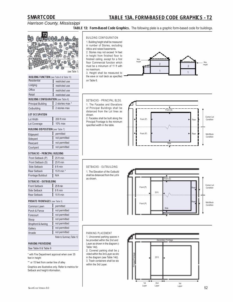
Harrison County, MississippiSMARTCODE
SMARTCODE VERSION 9.0 52
EdgeyardSideyardRearyardCourtyard
BUILDING DISPOSITION (see Table 7)
not permittednot permitted
permittednot permitted
(see Table 1)
Common LawnPorch & FenceForecourtStoopShopfront & AwningGalleryArcade
PRIVATE FRONTAGES (see Table 5)
permittednot permittednot permittednot permittednot permittednot permittednot permitted
Front SetbackSide SetbackRear Setback
SETBACKS - OUTBUILDING25 ft min 8 ft min15 ft min
SETBACKS - PRINCIPAL BUILDING25 ft min25 ft min8 ft min15 ft min *N/A
Front Setback (P) Front Setback (S) Side SetbackRear SetbackFrontage Buildout
BUILDING CONFIGURATION (see Table 6) Principal BuildingOutbuilding
2 stories max *2 stories max
Lot WidthLot Coverage
LOT OCCUPATION
10% max200 ft min
Refer to Summary Table 12
PARKING PROVISIONSSee Table 8 & Table 9
T2
* with Fire Department approval when over 35 feet in height** or 15 feet from center line of alleyGraphics are illustrative only. Refer to metrics for Setback and height information.
TABLE 13A. FORM-BASED CODE GRAPHICS - T2
ResidentialLodgingOffi ceRetail
BUILDING FUNCTION (see Table 8 & Table 10) restricted userestricted userestricted userestricted use
SETBACKS - OUTBUILDING1. The Elevation of the Outbuilding shall be distanced from the Lot lines as shown.
BUILDING CONFIGURATION1. Building height shall be measured in number of Stories, excluding Attics and raised basements.2. Stories may not exceed 14 feet in height from finished floor to fi nished ceiling, except for a fi rst floor Commercial function which must be a minumum of 11 ft with no maximum.3. Height shall be measured to the eave or roof deck as specifi ed on Table 6.
SETBACKS - PRINCIPAL BLDG.1. The Facades and Elevations of Principal Buildings shall be distanced from the Lot lines as shown. 2. Facades shall be built along the Principal Frontage to the minimum specifi ed width in the table.
PARKING PLACEMENT1. Uncovered parking spaces may be provided within the 2nd and 3rd Layer as shown in the diagram (see Table 14d). 2. Covered parking shall be pro-vided within the 3rd Layer as shown in the diagram (see Table 14d). 3. Trash containers shall be stored within the 3rd Layer.
Corner LotCondition
Mid-Block Condition
1
2
Max. height Max.
height
1
2
Front (P)
Front (S)
Side
RearCorner LotCondition
Mid-Block Condition
20 ft.
25 ft.
Side
RearFront (P)
Front (S)
Rear Front (P)
Front (P)Rear
Princ
ipal F
ronta
ge
Secondary Frontage
2nd Layer
1stLayer
3rd Layer
TABLE 13: Form-Based Code Graphics. The following plate is a graphic form-based code for buildings.
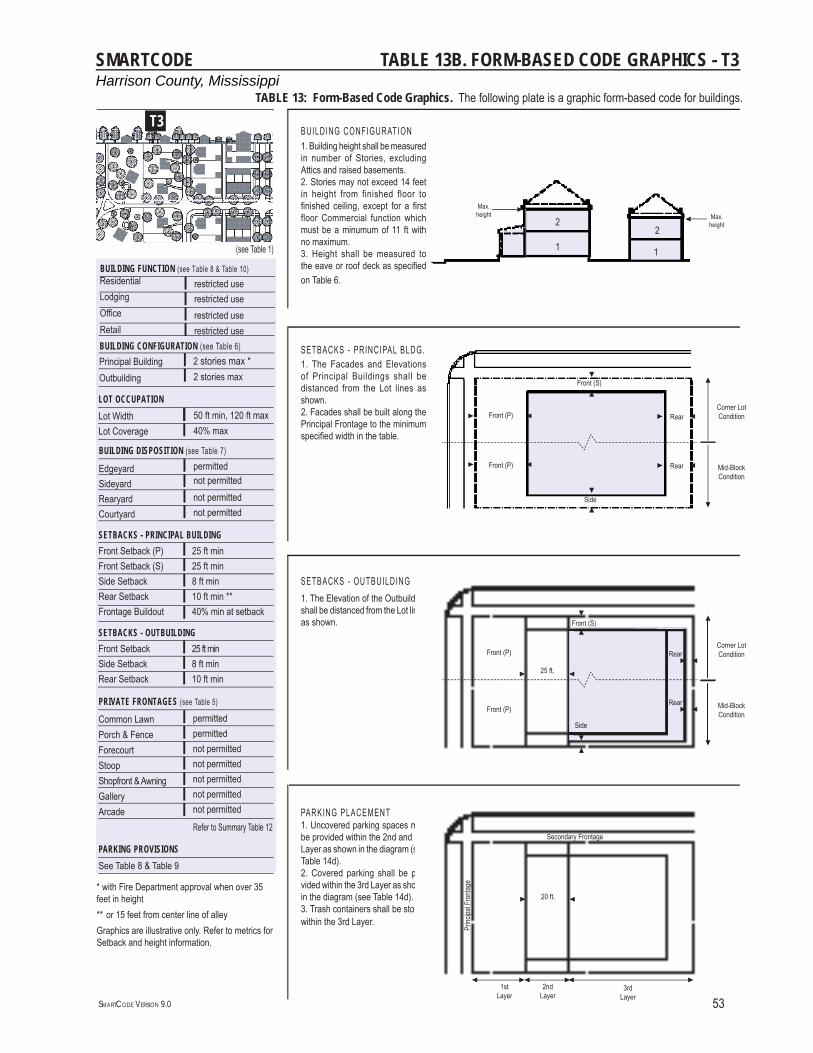
Harrison County, MississippiSMARTCODE
SMARTCODE VERSION 9.0 53
EdgeyardSideyardRearyardCourtyard
BUILDING DISPOSITION (see Table 7)
not permittednot permitted
permittednot permitted
(see Table 1)
Common LawnPorch & FenceForecourtStoopShopfront & AwningGalleryArcade
PRIVATE FRONTAGES (see Table 5)
permittedpermittednot permittednot permittednot permittednot permittednot permitted
Front SetbackSide SetbackRear Setback
SETBACKS - OUTBUILDING25 ft min8 ft min10 ft min
SETBACKS - PRINCIPAL BUILDING25 ft min25 ft min8 ft min10 ft min **40% min at setback
Front Setback (P)Front Setback (S)Side SetbackRear SetbackFrontage Buildout
BUILDING CONFIGURATION (see Table 6) Principal BuildingOutbuilding
2 stories max *2 stories max
Lot WidthLot Coverage
LOT OCCUPATION
40% max50 ft min, 120 ft max
Refer to Summary Table 12
PARKING PROVISIONSSee Table 8 & Table 9
T3
* with Fire Department approval when over 35 feet in height** or 15 feet from center line of alleyGraphics are illustrative only. Refer to metrics for Setback and height information.
TABLE 13B. FORM-BASED CODE GRAPHICS - T3
ResidentialLodgingOffi ceRetail
BUILDING FUNCTION (see Table 8 & Table 10) restricted userestricted userestricted userestricted use
SETBACKS - OUTBUILDING1. The Elevation of the Outbuilding shall be distanced from the Lot lines as shown.
BUILDING CONFIGURATION1. Building height shall be measured in number of Stories, excluding Attics and raised basements.2. Stories may not exceed 14 feet in height from finished floor to fi nished ceiling, except for a fi rst floor Commercial function which must be a minumum of 11 ft with no maximum.3. Height shall be measured to the eave or roof deck as specifi ed on Table 6.
SETBACKS - PRINCIPAL BLDG.1. The Facades and Elevations of Principal Buildings shall be distanced from the Lot lines as shown. 2. Facades shall be built along the Principal Frontage to the minimum specifi ed width in the table.
PARKING PLACEMENT1. Uncovered parking spaces may be provided within the 2nd and 3rd Layer as shown in the diagram (see Table 14d). 2. Covered parking shall be pro-vided within the 3rd Layer as shown in the diagram (see Table 14d). 3. Trash containers shall be stored within the 3rd Layer.
Corner LotCondition
Mid-Block Condition
1
2Max.
height Max. height
1
2
Front (P)
Front (S)
Side
RearCorner LotCondition
Mid-Block Condition
20 ft.
25 ft.
Side
RearFront (P)
Front (S)
Rear Front (P)
Front (P)Rear
Princ
ipal F
ronta
ge
Secondary Frontage
2nd Layer
1stLayer
3rd Layer
TABLE 13: Form-Based Code Graphics. The following plate is a graphic form-based code for buildings.
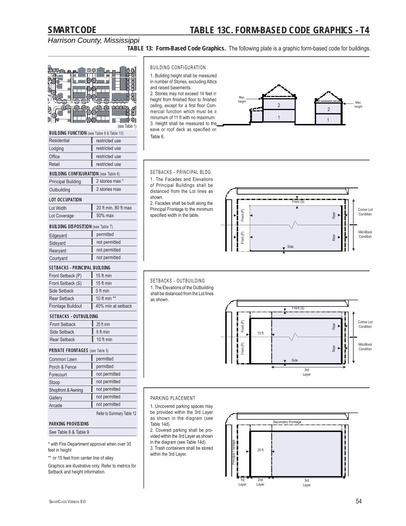
Harrison County, MississippiSMARTCODE
SMARTCODE VERSION 9.0 54
Common LawnPorch & FenceForecourtStoopShopfront & AwningGalleryArcade
PRIVATE FRONTAGES (see Table 5)
permittedpermittednot permittednot permittednot permittednot permittednot permitted
EdgeyardSideyardRearyardCourtyard
BUILDING DISPOSITION (see Table 7)
not permittednot permitted
permittednot permitted
(see Table 1)
ResidentialLodgingOffi ceRetail
BUILDING FUNCTION (see Table 8 & Table 10) restricted userestricted userestricted userestricted use
BUILDING CONFIGURATION (see Table 6) 2 stories max *2 stories max
Principal BuildingOutbuilding
Front SetbackSide SetbackRear Setback
SETBACKS - OUTBUILDING 25 ft min8 ft min10 ft min
SETBACKS - PRINCIPAL BUILDING15 ft min15 ft min5 ft min10 ft min **40% min at setback
Front Setback (P)Front Setback (S)Side SetbackRear SetbackFrontage Buildout
Lot WidthLot Coverage
LOT OCCUPATION
50% max20 ft min, 80 ft max
T4
Refer to Summary Table 12
PARKING PROVISIONSSee Table 8 & Table 9
TABLE 13C. FORM-BASED CODE GRAPHICS - T4
* with Fire Department approval when over 35 feet in height** or 15 feet from center line of alleyGraphics are illustrative only. Refer to metrics for Setback and height information.
Corner LotCondition
Mid-Block Condition
Side
BUILDING CONFIGURATION
SETBACKS - PRINCIPAL BLDG.1. The Facades and Elevations of Principal Buildings shall be distanced from the Lot lines as shown. 2. Facades shall be built along the Principal Frontage to the minimum specifi ed width in the table.
1. The Elevations of the Outbuilding shall be distanced from the Lot lines as shown.
SETBACKS - OUTBUILDING
PARKING PLACEMENT1. Uncovered parking spaces may be provided within the 3rd Layer as shown in the diagram (see Table 14d). 2. Covered parking shall be pro-vided within the 3rd Layer as shown in the diagram (see Table 14d). 3. Trash containers shall be stored within the 3rd Layer.
1. Building height shall be measured in number of Stories, excluding Attics and raised basements.2. Stories may not exceed 14 feet in height from fi nished fl oor to fi nished ceiling, except for a fi rst fl oor Com-mercial function which must be a minumum of 11 ft with no maximum.3. Height shall be measured to the eave or roof deck as specified on Table 6.
15 ft.
Corner LotCondition
Mid-Block Condition
2nd Layer
3rd Layer
1stLayer
Rear
Side
20 ft.
Fron
t (P)
Front (S)
3rd Layer
Front (S)
Fron
t (P)
Rear
Rear
Fron
t (P)
Fron
t (P)
Rear
Princ
ipal F
ronta
ge
Secondary Frontage
d s
nd-a.en
-
e 1
2Max.
height Max. height
1
2
TABLE 13: Form-Based Code Graphics. The following plate is a graphic form-based code for buildings.
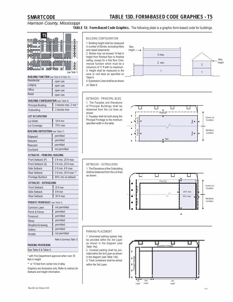
Harrison County, MississippiSMARTCODE
SMARTCODE VERSION 9.0 55
(see Table 1)
EdgeyardSideyardRearyardCourtyard
BUILDING DISPOSITION (see Table 7)
permittednot permitted
permittedpermitted
ResidentialLodgingOffi ceRetail
BUILDING FUNCTION (see Table 8 & Table 10) open useopen useopen useopen use
Common LawnPorch & FenceForecourtStoopShopfront & AwningGalleryArcade
PRIVATE FRONTAGES (see Table 5)
not permittedpermittedpermittedpermittedpermittedpermittednot permitted
Front SetbackSide SetbackRear Setback
SETBACKS - OUTBUILDING25 ft max8 ft min30 ft max
SETBACKS - PRINCIPAL BUILDING0 ft min, 25 ft max0 ft min, 25 ft max0 ft min, 8 ft max3 ft min, 30 ft max **60% min at setback
Front Setback (P)Front Setback (S)Side SetbackRear SetbackFrontage Buildout
BUILDING CONFIGURATION (see Table 6) Principal BuildingOutbuilding
3 stories max, 2 min *2 stories max
Lot WidthLot Coverage
LOT OCCUPATION
70% max18 ft min
T5
PARKING PROVISIONSSee Table 8 & Table 9
Refer to Summary Table 12
TABLE 13D. FORM-BASED CODE GRAPHICS - T5
* with Fire Department approval when over 35 feet in height** or 15 feet from center line of alleyGraphics are illustrative only. Refer to metrics for Setback and height information.
TABLE 13: Form-Based Code Graphics. The following plate is a graphic form-based code for buildings.
SETBACKS - PRINCIPAL BLDG.
BUILDING CONFIGURATION
1. The Facades and Elevations of Principal Buildings shall be distanced from the Lot lines as shown. 2. Facades shall be built along the Principal Frontage to the minimum specifi ed width in the table.
1. Uncovered parking spaces may be provided within the 3rd Layer as shown in the diagram (see Table 14d). 2. Covered parking shall be pro-vided within the 3rd Layer as shown in the diagram (see Table 14d). 3. Trash containers shall be storedwithin the 3rd Layer.
PARKING PLACEMENT
SETBACKS - OUTBUILDING1. The Elevations of the Outbuilding shall be distanced from the Lot lines as shown.
1. Building height shall be measured in number of Stories, excluding Attics and raised basements.2. Stories may not exceed 14 feet in height from fi nished fl oor to fi nished ceiling, except for a fi rst fl oor Com-mercial function which must be a minumum of 11 ft with no maximum.3. Height shall be measured to the eave or roof deck as specifi ed on Table 6.4. Expression Lines shall be as shown on Table 6.
1
2 2 min.
3 max.
1
25 ft. max.
Corner LotCondition
Mid-Block Condition
30 ft. max.
2nd Layer
3rd Layer
1st Layer
Fron
t (P)
Front (S)
Fron
t (P)
Princ
ipal F
ronta
ge
Secondary Frontage
Max. height
Max.height
Corner LotCondition
Mid-Block Condition
Fron
t (P)
Front (S)
Side
Rear
Fron
t (P)
Rear
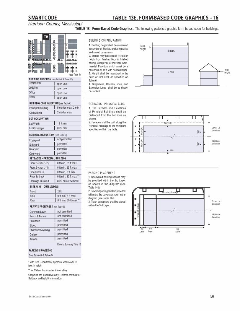
Harrison County, MississippiSMARTCODE
SMARTCODE VERSION 9.0 56
(see Table 1)
EdgeyardSideyardRearyardCourtyard
BUILDING DISPOSITION (see Table 7)
permittedpermitted
not permittedpermitted
ResidentialLodgingOffi ceRetail
BUILDING FUNCTION (see Table 8 & Table 10) open useopen useopen useopen use
Common LawnPorch & FenceForecourtStoopShopfront & AwningGalleryArcade
PRIVATE FRONTAGES (see Table 5)
not permittednot permittedpermittedpermittedpermittedpermittedpermitted
FrontSideRear
SETBACKS - OUTBUILDING 25 ft0 ft min, 8 ft max0 ft min, 30 ft max **
SETBACKS - PRINCIPAL BUILDING 0 ft min, 25 ft max0 ft min, 25 ft max0 ft min, 8 ft max0 ft min, 30 ft max **80% min at setback
Front Setback (P)Front Setback (S)Side SetbackRear SetbackFrontage Buildout
BUILDING CONFIGURATION (see Table 6) Principal BuildingOutbuilding
5 stories max, 2 min *2 stories max
Lot WidthLot Coverage
LOT OCCUPATION
80% max18 ft min
T6
PARKING PROVISIONSSee Table 8 & Table 9
Refer to Summary Table 12
TABLE 13E. FORM-BASED CODE GRAPHICS - T6
* with Fire Department approval when over 35 feet in height** or 15 feet from center line of alleyGraphics are illustrative only. Refer to metrics for Setback and height information.
TABLE 13: Form-Based Code Graphics. The following plate is a graphic form-based code for buildings.
SETBACKS - PRINCIPAL BLDG.
BUILDING CONFIGURATION
1. The Facades and Elevations of Principal Buildings shall be distanced from the Lot lines as shown. 2. Facades shall be built along the Principal Frontage to the minimum specifi ed width in the table.
PARKING PLACEMENT
1. Building height shall be measured in number of Stories, excluding Attics and raised basements.2. Stories may not exceed 14 feet in height from fi nished fl oor to fi nished ceiling, except for a fi rst fl oor Com-mercial Function which must be a minumum of 11 ft with no maximum.3. Height shall be measured to the eave or roof deck as specified on Table 6.4. Stepbacks, Recess Lines, and Extension Lines shall be as shown on Table 6.
Max. height
Max. height
Corner LotCondition
Mid-Block Condition
Corner LotCondition
Mid-Block Condition
5 max.
2 min.
2nd Layer
3rd Layer
1st Layer
Fron
t (P)
Front (S)
Side
Rear
Princ
ipal F
ronta
ge
SecondaryFrontage
Fron
t (P)
Rear
1. Uncovered parking spaces may be provided within the 3rd Layer as shown in the diagram (see Table 14d). 2. Covered parking shall be provided within the 3rd Layer as shown in the diagram (see Table 14d). 3. Trash containers shall be stored within the 3rd Layer.
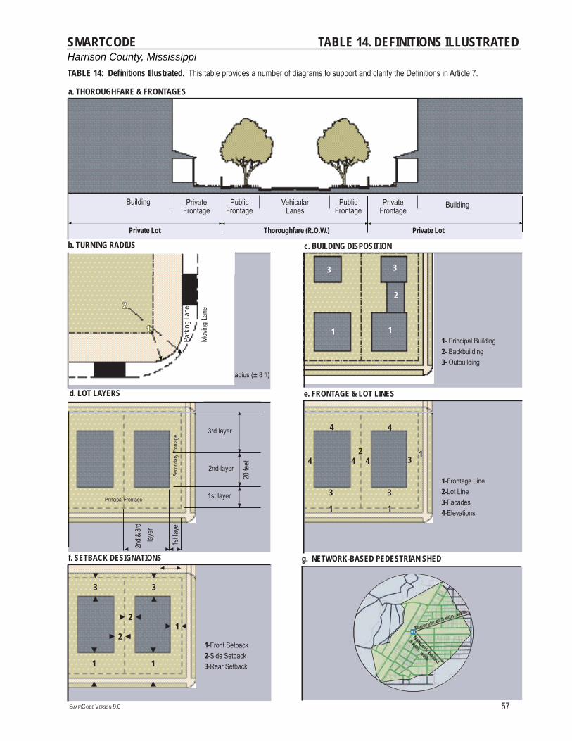
Harrison County, MississippiSMARTCODE
SMARTCODE VERSION 9.0 57
TABLE 14. DEFINITIONS ILLUSTRATED
Thoroughfare (R.O.W.)
a. THOROUGHFARE & FRONTAGES
1-Radius at the Curb2-Effective Turning Radius (± 8 ft)
b. TURNING RADIUS
1-Frontage Line 2-Lot Line 3-Facades 4-Elevations
e. FRONTAGE & LOT LINES
1st layer
2nd layer
3rd layer
20 fe
et
d. LOT LAYERS
1- Principal Building2- Backbuilding3- Outbuilding
c. BUILDING DISPOSITION
BuildingPrivateFrontage
PublicFrontage
Vehicular Lanes
PublicFrontage
PrivateFrontage
Building
Private LotPrivate Lot
Parki
ng La
ne
Movin
g Lan
e
1
22
11 1
2
33
224
3
3
4 4
1
1
3
1
4 4
f. SETBACK DESIGNATIONS
1
1
1-Front Setback2-Side Setback3-Rear Setback
3 3
1
2
2
g. NETWORK-BASED PEDESTRIAN SHED
1st la
yer
2nd &
3rd
laye
r
Principal Frontage
Seco
ndar
y Fro
ntage
TABLE 14: Defi nitions Illustrated. This table provides a number of diagrams to support and clarify the Defi nitions in Article 7.
Harrison County, MississippiSMARTCODE
SMARTCODE VERSION 9.0 58
DEFINITIONS This Article provides defi nitions for terms in this Code that are technical in nature or
that otherwise may not refl ect a common usage of the term. If a term is not defi ned in this Article, then the Planning Offi ce shall determine the correct defi nition of the term.
Absolute Maximum Density Allowance: the maximum number of Equivalent Housing Units which may be constructed on a lot through any means, including by Right or by Density Bonus. The Absolute Maximum Density Allowance is determined by multiplying the appropriate Absolute Maximum Building-Scale Density by the area of the lot. Under no circumstances may a lot’s Density Allowance exceed the lot’s Absolute Maximum Density Allowance.
Accessory Building: any building which is subordinate or incidental to the main building or use of a lot.
Affordable Housing: dwellings consisting of rental units or for-sale units. Both shall be economically within the means of the equivalent of the starting salary of a local elementary school teacher.
Allee: a regularly spaced and aligned row of trees usually planted along a Thorough-fare or Pedestrian Path.
Ancillary Unit: an apartment not greater than 600 square feet sharing ownership and utility connections with a Principal Building. An Ancillary Unit may or may not be within an outbuilding. Ancillary Units do not count toward maximum density calculations. See Tables 9 & 14.
Apartment Building: any structure or building designed for use by three or more households living independently of each other as separate housekeeping units, including apartment houses, apartment hotels, fl ats, and townhouses or condominiums, but not including auto or trailer courts or camps, hotels, motels, or resort-type hotels.
Avenue (AV): a thoroughfare of high vehicular capacity and low speed. Avenues are short distance connectors between urban centers. Avenues may be equipped with a landscaped median. Avenues become collectors upon exiting urban areas. Backbuilding: a single-story structure connecting a principal building to an outbuilding. See Table 14.
Bed and Breakfast: an owner-occupied single-family dwelling, or portion thereof, where short-term lodging is provided, with or without meals, for compensation, to transient guests only. Meals may be provided to guests only. Up to fi ve (5) guest rooms may be provided.
Bed and Breakfast Inn: a single-family dwelling, or portion thereof, where short-term lodging is provided for compensation to transient guests only. The operator may or may not live on the premises. Meals may be provided to guests only. Up to fi fteen (15) guest rooms may be provided.
Bicycle Lane (BL): a dedicated bicycle lane running within a moderate speed vehicular thoroughfare, demarcated by striping. Bicycle Route (BR): a thoroughfare suitable for the shared use of bicycles and automobiles moving at low speeds.
ARTICLE 7. DEFINITIONS OF TERMS
Harrison County, MississippiSMARTCODE
SMARTCODE VERSION 9.0
ARTICLE 7. DEFINITIONS OF TERMS
59
Bicycle Trail (BT): a bicycle way running independently of a high speed vehicular thoroughfare.
Block: the aggregate of private lots, passages, rear lanes and alleys, circumscribed by thoroughfares.
Block Face: the aggregate of all the building facades on one side of a block. The Block Face provides the context for establishing architectural harmony.
Boulevard (BV): a thoroughfare designed for high vehicular capacity and moderate speed. Boulevards are long distance thoroughfares traversing urbanized areas. Boulevards are usually equipped with slip roads buffering sidewalks and buildings. Boulevards become arterials upon exiting urban areas.
Brownfi eld: an area previously used primarily as an industrial site. Building Confi guration: the form of a building, based on its massing, private
frontage, and height. Building Disposition: the placement of a building on its lot. See Table 7. Building Function: the uses accommodated by a building and its lot. Functions
are categorized as Restricted, Limited, or Open, according to the intensity of the use. See Tables 9 & 10.
Building Height: the vertical extent of a building measured in stories, not including a raised basement or a habitable attic. Height limits do not apply to masts, belfries, clock towers, chimney fl ues, water tanks, elevator bulkheads and similar structures. Building Height shall be measured from the average grade of the enfronting thoroughfare. See Table 6.
Building-Scale Density: the number of Equivalent Housing Units per unit of Lot-Level Area of a development.
Building Standards: Requirements for the design, construction, maintenance, and occupancy of developments.
Building Type: a structure category determined by function, disposition on the lot, and confi guration, including frontage and height.
Bus Station: a terminal that serves bus passengers. By-Right Density Allowance: the Lot Density Allowance obtained by multiplying
the Maximum Building-Scale Density for the appropriate Transect Z one by the area of a particular lot. The By-Right Density Allowance represents the maximum number of Equivalent Housing Units which can be constructed on a lot by right, without acquiring additional density rights. The total Lot Density Allowance may be increased from the By-Right Density Allowance through Density Transfers and Bonuses. See Lot Density Allowance.
By Right Permit: a proposal for a building or community plan that complies with this code and may thereby be processed administratively, without public hearing. See Variance.
Child Care Center: an establishment providing care for four or more children. The term “child care center” includes day care nurseries, day care centers and any other facilities that fall within the scope of the defi nition set forth herein, regardless of auspices. Exempted from this defi nition is any facility operating as a
Harrison County, MississippiSMARTCODE
SMARTCODE VERSION 9.0
ARTICLE 7. DEFINITIONS OF TERMS
60
kindergarten, nursery school or head start in conjunction with an elementary and/or secondary school system, whether it be public, private or parochial, whose primary purpose is a structured school readiness program. The Mississippi State Board of Health shall stipulate space requirements.
Civic: the term defi ning not for profi t organizations dedicated to arts, culture, education, recreation, government, transit, and municipal parking.
Civic Building: a building designed specifi cally for a civic function. Civic Buildings shall not be subject to the requirements of Article 5. The particulars of their design shall be determined by Variance.
Civic Parking Reserve: parking structure or lot within a quarter mile of the site that it serves. Space may be leased or bought from this Reserve to satisfy parking requirements.
Civic Space: an outdoor area dedicated for public use. Civic Space types are defi ned by the combination of certain physical constants including the relationship between their intended use, their size, their landscaping and their enfronting buildings. See Table 11.
CLD: Conservation Land Development, Clustered Land Development. An incomplete neighborhood, standing free in the countryside. Because of a location away from transportation, CLD has a weak commercial center. This is the only Community type permitted by Right in the Restricted Growth Sector. (Syn: Hamlet, Cluster)
Commercial: the term collectively defi ning workplace, offi ce and retail functions. Common Destination: an area of focused community activity defining the
approximate center of a Pedestrian Shed. It may include without limitation one or more of the following: a Civic Space, a Civic Building, a Commercial center, a bus stop. A Common Destination may act as the social center of a Neighborhood.
See Section 3.7. Communication Tower: a guyed, monopole, or self-supporting tower, constructed
as a free standing structure. Community Plan: a governing plan for the development and maintenance of a
district which may include one or several Neighborhoods and/or Urban Centers. A Community Plan includes at a minimum a Regulating Plan, detailing the layout of the Transect zone districts over the Community, a Special Requirements Plan, describing additional details and requirements, and a Streets and Parking Plan. The Community Plan may include other specifi cations as well.
Community Planning Area: the geographic extent governed by a Community Plan.
Community Type: a category defi ning the physical form of a settlement. The three basic Community Types addressed in this Code are CLD, TND, and RCD/TOD. The choice of Community Type will depend upon the regional Sector, level of urban intensity desired, particulars of the site, transportation, and implementation.
Consolidated Review Committee (CRC): usually part of the Planning Offi ce, a CRC is composed of one representative from each of the regulatory agencies that have jurisdiction over the permitting of a project.
Harrison County, MississippiSMARTCODE
SMARTCODE VERSION 9.0
ARTICLE 7. DEFINITIONS OF TERMS
61
Context: surroundings made up of the particular combination of elements that create specifi c habitat.
Convention Center: a large civic building or group of buildings designed for conventions, industrial shows, and the like, having large unobstructed exhibit areas and often including conference rooms, and other facilities.
Corridor: a lineal geographic system incorporating transportation and/or greenway trajectories. A transportation corridor may be a lineal urban Transect Zone.
Courtyard Building: a building that occupies the boundaries of its lot while internally defi ning one or more private patios.
Curb: the edge of the vehicular pavement detailed as a raised curb or fl ush to a swale. The Curb usually incorporates the drainage system. See Table 4.
DDC: Design and Development Center. See UDC. Density: the number of dwellings units per area acre. For the SmartCode of
the unincorporated Harrison County density is calculated as follows: Number of residential units + (Square footage of non-residential X conversion factor) % of acreage of community type (CLD, TND, RCD) X by right density Acreage of Project. See Section 3.4.
Density Allowance: see Lot Density Allowance. Design Speed: is the velocity at which a thoroughfare tends to be driven without
the constraints of signage or enforcement. There are three ranges of speed: Very Low: (below 20 MPH); Low: (20-25 MPH); Moderate: (25-35 MPH); High: (above 35 MPH). Lane width is determined by desired design speed.
Developable areas: residual to the Preserved Open Sector. District: see Special District. Driveway: a vehicular lane within a lot, usually leading to a garage. A Driveway in
the First Layer may be used for parking if it is no more than 18 feet wide, thereby becoming subject to the constraints of a parking lot.
Dwelling: a building or portion thereof, designed and used exclusively for residential occupancy.
Dwelling, Duplex: a building designed for or occupied exclusively by two households.
Dwelling, Guest Cottage: an attached or detached accessory structure secondary to a principal detached single household dwelling; designed and most commonly used for irregular residential occupancy by family members, guests, and persons providing health care or property maintenance for the owner. Terms commonly used to describe a guest cottage are mother-in-law’s house, pool house, and grounds keeper’s cottage.
Edgeyard Building: a building that occupies the center of its lot with setbacks on all sides.
Elevation: an exterior wall of a building not along a Frontage Line. See Facade, Table 14.
Enfront: to place an element along a frontage line, as in “porches enfront the

Harrison County, MississippiSMARTCODE
SMARTCODE VERSION 9.0
ARTICLE 7. DEFINITIONS OF TERMS
62
street.” Entrance, Principal: the main point of access of pedestrians into a building. Equivalent Housing Unit (EHU): an abstracted measure of development (Function
Volume) variously equivalent to one Independent Residential Unit, two bedrooms of Lodging, 1000 square feet of Retail fl oor space, or 1000 feet of Offi ce fl oor space. EHUs are used in calculating densities for mixed-use environments.
Estate House: an edgeyard building type. A single-family dwelling on a very large lot of rural character, often shared by one or more ancillary buildings. (Syn: Country house, Villa)
Facade: the exterior wall of a building that is set along a Frontage Line. See Elevation; Frontage Line.
Frontage Line: those lot lines that coincide with a public frontage. Facades along Frontage Lines defi ne the public realm and are therefore more regulated than the elevations that coincide with other Lot Lines. See Table 14.
Function Volume: an indication of the number of distinct instances of functions at a particular site, measured in Equivalent Housing Units. See Building Function.
Garage, Public: a building other than a private or storage garage, used for the care, repair, or storage of self-propelled vehicles or where such vehicles are kept for remuneration, hire, or sale. This includes premises commonly known as fi lling stations or service stations.
GIS (Geographic Information System): a computerized program in wide-spread municipal use that organizes data on maps. Various municipal departments can input information including the location of wetlands, thorough-fares, water/sewer lines, boundaries, building footprints, schools, zoning, land-use, etc. GIS makes information available as layered databases. The protocol for preparing a Sector Plan should be based on GIS information. See Section 2.1.
Golf Course: premises having not fewer than nine holes improved with tees, greens, fairways, and hazards for playing the game of golf, not including driving ranges or miniature golf.
Greenfi eld: a project planned for an undeveloped area outside the existing urban fabric. See Infi ll.
Greenhouse: a structure, primarily of glass, in which temperature and humidity can be controlled for the cultivation or protection of plants.
Greenway: an open space corridor in largely natural conditions which may include Trails for bicycles and pedestrians.
Greyfi eld: an area previously used primarily as a parking lot. Shopping centers and shopping malls are typical Greyfi eld sites.
Growth Sector: one of the three Sectors for New Communities or the Infi ll Sector, where development is permitted by right.
Hamlet: see CLD. Home Occupation: non-retail commercial enterprises permitted in Zones T3-6.
The work quarters should be invisible from the frontage, located either within the
Harrison County, MississippiSMARTCODE
SMARTCODE VERSION 9.0
ARTICLE 7. DEFINITIONS OF TERMS
63
house or in an outbuilding. Permitted activities are defi ned by the Restricted Offi ce category. See Table 9.
House: an edgeyard building type. A single-family dwelling on a large lot, often shared with an ancillary building in the rearyard. (Syn: Single)
Independent Building: a building designed by a different architect from the adjacent buildings.
Infi ll: a project within existing urban fabric. Inside Turning Radius: the curved edge of a thoroughfare at an intersection,
measured at the inside edge of the vehicular tracking. The smaller the Turning Radius, the smaller the pedestrian crossing distance and the more slowly the vehicle is forced to make the turn. See Tables 3 and 14.
Kennel, Commercial: any facility wherein any person engages in the business of boarding, breeding, buying, letting for hire, training for a fee, or selling dogs or cats, or where there are regularly kept four or more adult dogs or cats, or any combination thereof.
Kiosk: a small structure with one or more open sides that is used to sell or promote merchandise or services.
Layer: a range of depth of a lot within which certain elements are permitted. See Table 14.
Linear Pedestrian Shed: a Pedestrian Shed that is elongated along an important Commercial corridor such as a main street. The resulting shed is shaped like a lozenge. (Sometimes called an Elongated Pedestrian Shed.)
Liner Building: a building specifi cally designed to mask a parking lot or a parking garage from a frontage. A Liner Building, if less than 30 feet deep and two stories, shall be exempt from parking requirements.
Live-Work: a fee-simple dwelling unit that contains a Commercial component anywhere in the unit. See Work-Live. (Syn: Flexhouse)
Lodging: premises available for daily and weekly renting of bedrooms. The area allocated for food service shall be calculated and provided with parking according to retail use.
Long Pedestrian Shed: a Pedestrian Shed of 1/2 mile radius used for mapping community types when a transit stop (bus or rail) is present or proposed as the Common Destination. People have been shown to walk ten minutes to transit. See Pedestrian Shed.
Lot Density Allowance: the maximum number of Equivalent Housing Units which may be constructed on a lot. The Lot Density Allowance may be increased from the By-Right Density Allowance through Density Bonuses, and is then the sum of the By-Right and the Acquired Density Allowances, but in no case may the total number of units exceed the Absolute Maximum Density Allowance. See Absolute Maximum Density Allowance, By-Right Density Allowance).
Lot Line: the boundary that legally and geometrically demarcates a lot (see Frontage Line). Such lines appear graphically on Community and Site Plans. Codes reference lot lines as the baseline for measuring setbacks. See Tables 12 and 14.
Harrison County, MississippiSMARTCODE
SMARTCODE VERSION 9.0
ARTICLE 7. DEFINITIONS OF TERMS
64
Lot Width: the length of the principal Frontage Line of a lot. Manufacturing: premises available for the creation, assemblage and/or repair of
artifacts, using table-mounted electrical machinery and including their retail sale. Marina: a boat basin, harbor or dock, with facilities for berthing and servicing
boats which may include the provision of bait, ice and fi shing tackle and eating establishments.
Meeting Hall: a building available for gatherings, including conferences. It should accommodate at least one room equivalent to a minimum of 10 square feet per projected dwelling unit within the pedestrian shed in which the meeting hall is located. A Meeting Hall shall be completed upon the sale of 75% of the dwelling units. The Meeting Hall may be used for the marketing purposes of the development until the sale of 75% of the dwelling units, at which time control of its use shall be given to the Board of Supervisors.
Mini-Warehouse Storage: a wholly enclosed building used for the storage of personal property in self-contained, self-storage units, each of which units has separate and exclusive access from either the exterior or interior of the building.
Museum: a building devoted to the acquisition, conservation, study, exhibition, and educational interpretation of objects.
Neighborhood: a mostly residential area, often but not necessarily with a recognizable edge, based on a mapped Pedestrian Shed with a mixed-use center or corridor.
Net Developable Area, Net Site Area: the developable areas of a site. The Net Site Area shall be allocated to the various Transect Zones according to the parameters in Table 12.
Offi ce Building: a building designed for or used as offi ces for professional, commercial, industrial, religious, public or semi-public activities or organizations providing that no manufactured products or commodities are warehoused or sold on the premises.
Open Sector: one of the two Sectors where development is not permitted. Outbuilding: an accessory building, usually located towards the rear of the same
lot as a Principal Building. It is sometimes connected to the principal building by a Backbuilding. Outbuildings shall not exceed 600 square feet of habitable space, excluding parking areas. See Table 14.
Parking Structure: a building containing two or more stories of parking. Parking Structures shall have Liner Buildings at the fi rst story or higher.
Passage (PS): a pedestrian connector passing between buildings, providing shortcuts through long blocks and connecting rear parking areas to frontages. Passages may be roofed over.
Path (PT): a pedestrian way traversing a park or rural area, with landscape matching the contiguous open space. Paths should connect directly with the urban sidewalk network.
Pedestrian Shed: an area, approximately circular, that is centered on a Common Destination. A Pedestrian Shed is applied to determine the approximate size of
Harrison County, MississippiSMARTCODE
SMARTCODE VERSION 9.0
ARTICLE 7. DEFINITIONS OF TERMS
65
a Neighborhood. A Standard Pedestrian Shed is 1/4 mile radius or 1320 feet, about the distance of a fi ve-minute walk at a leisurely pace. It has been shown that provided with a pedestrian environment, most people will walk this distance rather than drive. The outline of the shed must be refi ned according to actual site conditions, particularly along Thoroughfares. The Common Destination should have the present or future capacity to accommodate a T5 Transect Zone for TND and a T6 Zone for RCD. A Long Pedestrian Shed is 1/2 mile radius or 2640 feet, and may be used for mapping when transit is present or proposed. (Sometimes called a “walkshed” or “walkable catchment.”) A Linear Pedestrian Shed is elongated to follow a Commercial corridor. See Standard, Long, or Linear Pedestrian Shed.
Planter: the element of the public streetscape which accommodates street trees. Planters may be continuous or individual. Primary-Secondary Grid: thoroughfare designations appearing on the Regulating Plan. Buildings on the P-Grid are subject to all of the provisions of this Code. Buildings on the S-Grid are exempt from certain provisions, allowing for approved open parking lots, unlined parking decks, drive-throughs and hermetic building fronts.
Playground: an outdoor area set aside for recreation and play, it could contain equipment such as seesaws and swings.
Principal Building: the main building on a lot, usually located toward the frontage. See Table 14.
Private Frontage: the privately held layer between the frontage line and the principal building facade. The structures and landscaping within the Private Frontage may be held to specifi c standards. The variables of Private Frontage are the depth of the setback and the combination of architectural elements such as fences, stoops, porches and galleries. See Table 5.
Public Art: works of art in any artistic medium (bronze, stone, paint, etc) for temporary or permanent placement in outdoor or indoor settings.
Public Frontage: the area between the curb of the vehicular lanes and the Frontage Line. Elements of the Public Frontage include the type of curb, walk, planter, street tree and streetlight. See Table 4.
Public-Parking Facility: a parking structure or surface parking lot which offers parking spaces to the general public for a fee on an as-available basis. A Public Parking Facility as described herein need not be publicly owned and operated. The parking spaces in Public Parking Facilities are Unbundled: that is, they are freely available for lease on the open market, rather than being permanently associated with one business, with one building, or with one dwelling unit.
RCD or Regional Center Development: a Community Type based upon a partial or entire Long Pedestrian Shed, oriented toward a strong Town Center. The minimum developable area of an RCD/TOD is 160 acres. This Community Type is permitted by right within the G-3 Intended Growth Sector (see Section 3.3.3) and the G-4 Infi ll Growth Sector (see Section 4.3.2) RCD/TOD may be adjoined without buffers by one or several Standard Pedestrian Sheds that meet the individual Transect Zone requirements of an RCD as specifi ed in Tables 2 and 12.
Rear Alley (AL): a vehicular driveway located to the rear of lots providing access to service areas and parking, and containing utility easements. Alleys should be
Harrison County, MississippiSMARTCODE
SMARTCODE VERSION 9.0
ARTICLE 7. DEFINITIONS OF TERMS
66
paved from building face to building face, with drainage by inverted crown at the center or with roll curbs at the edges.
Rear Lane (LA): a vehicular driveway located to the rear of lots providing access to parking and outbuildings and containing utility easements. Rear lanes may be paved lightly to driveway standards. Its streetscape consists of gravel or landscaped edges, no raised curb and is drained by percolation.
Rearyard Building: a building that occupies the full frontage line, leaving the rear of the lot as the sole yard. This is a more urban type, as the continuous facade spatially defi nes the public thoroughfare. For its residential function, this type yields a rowhouse. For its commercial function, the rear yard can accommodate substantial parking.
Regional Centers: see RCD. Residential: premises available for long-term human dwelling. Retail: premises available for the sale of merchandise and food service. Retail Frontage Line: Frontage Lines designated on a Community Plan that
require the provision of a Shopfront, causing the ground level to be available for retail use.
Road (RD): a local, rural and suburban thoroughfare of low vehicular speed and capacity. Its public frontage consists of swales drained by percolation and a walking path or bicycle trail along one or both sides. The landscaping consists of multiple species composed in naturalistic clusters. This type is allocated to the more rural Transect Zones (T1-T3).
Row House: a single-family dwelling that shares a party wall with another of the same type and occupies the full frontage line. See Rearyard Building. (Syn: Townhouse)
Rural Boundary Line: the extent of potential urban growth as determined by existing geographical determinants. The rural boundary is permanent.
Sector: a neutral term for a geographic area. In the SmartCode there are six specifi c Sectors that establish the legal boundaries for several kinds of development. Two Sectors represent unbuildable open space (Preserve and Reserve) and the other four are Urban Growth Sectors of varying intensity (Restricted, Controlled, Intended and Infi ll Growth Sectors). Sectors address the legal status of place at the regional scale while Transect Zones address the physical character of communities. Sectors contain Community Types (CLD, TND, RCD, TOD), which contain Transect Zones, which contain design standards appropriate to those T-Zones. (Syn: Tier)
Service Boundary Line: the extent of potential or feasible urban growth as determined by the extension of infrastructure, principally sewer.
Setback: the area of a lot measured from the lot line to a building facade or elevation. This area must be maintained clear of permanent structures with the exception of: galleries, fences, garden walls, arcades, porches, stoops, balconies, bay windows, terraces and decks (that align with the fi rst story level) which are permitted to encroach into the Setback. See Section 5.2.1 and Table 9.
Shared Parking Policy: an accounting for parking spaces that are available to more
Harrison County, MississippiSMARTCODE
SMARTCODE VERSION 9.0
ARTICLE 7. DEFINITIONS OF TERMS
67
than one function. The requirement is reduced by a factor, shown as a calculation. The Shared Parking ratio varies according to multiple functions in close proximity which are unlikely to require the spaces at the same time. See Tables 9 and 10.
Sidewalk: the paved layer of the public frontage dedicated exclusively to pedestrian activity.
Sideyard Building: a building that occupies one side of the lot with a setback to the other side.
Special District (SD): Special District designations shall be assigned to areas that, by their intrinsic function, disposition, or confi guration, cannot conform to one of the six normative Transect Zones or four Community Types specifi ed by this Code. Typical Districts may include large parks, institutional campuses, refi nery sites, airports, etc.
Specialized Building: a building that is not subject to Residential, Commercial, or Lodging classifi cation. Most specialized buildings are dedicated to manufacturing and transportation, and are distorted by the trajectories of machinery.
Stable: a building that has stalls or compartments in which domestic animals are sheltered and fed.
Standard Pedestrian Shed: an area, approximately circular, that is centered on a Common Destination. A Pedestrian Shed is applied to determine the approximate size of a Neighborhood. A Standard Pedestrian Shed is 1/4 mile radius or 1320 feet, about the distance of a fi ve-minute walk at a leisurely pace. It has been shown that provided with a pedestrian environment, most people will walk this distance rather than drive. The outline of the shed must be refi ned according to actual site conditions, particularly along thoroughfares. (Sometimes called a “walkshed” or “walkable catchment.”) See Pedestrian Shed.
Story: a habitable level within a building of no more than 14 feet in height from fi nished fl oor to fi nished ceiling. Attics and raised basements are not considered stories for the purposes of determining building height.
Streamside Corridor: the zone within which a waterway fl ows, its width to be variably interpreted according to the Transect Zone.
Street (ST): a local urban thoroughfare of low speed and capacity. Its public frontage consists of raised curbs drained by inlets and sidewalks separated from the vehicular lanes by a planter and parking on both sides. The landscaping consists of regularly placed street trees. This type is permitted within the more urban Transect Zones (T4-T6).
Streetscape: the urban element that establishes the major part of the public realm. The streetscape is composed of thoroughfares (travel lanes for vehicles and bicycles, parking lanes for cars, and sidewalks or paths for pedestrians) as well as the visible private frontages (building facades and elevations, porches, yards, fences, awnings, etc.), and the amenities of the public frontages (street trees and plantings, benches, streetlights, etc.).
Streetscreen: sometimes called Streetwall. A freestanding wall built along the frontage line, or coplanar with the facade, often for the purpose of masking a parking lot from the thoroughfare. Streetscreens [should] be between 3.5 and 8
Harrison County, MississippiSMARTCODE
SMARTCODE VERSION 9.0
ARTICLE 7. DEFINITIONS OF TERMS
68
feet in height and constructed of a material matching the adjacent building facade. The streetscreen may be a hedge or fence by approval. Streetscreens shall have openings no larger than is necessary to allow automobile and pedestrian access. In addition, all streetscreens over [4 feet] high should be [30%] permeable or articulated to avoid blank walls.
Substantial Modifi cation: alterations to a building that are valued at more than 50% of the replacement cost of the entire building, if new.
Terminated Vista: a location at the axial conclusion of a thoroughfare. A building located at a Terminated Vista designated on a Community Plan is required to be designed in response to the axis.
Third Place: a private building that includes a space conducive to unstructured social gathering. Third Places are usually bars, cafés, and corner stores.
Thoroughfare: a vehicular way incorporating moving lanes and parking lanes within a right-of-way. See Tables 3 and 14.
Tier: see Sector. TND or Traditional Neighborhood Development: a Community Type based upon
a Standard Pedestrian Shed oriented toward a Common Destination consisting of a mixed use center or corridor, and having a minimum developable area of 80 acres. This Community Type is permitted by right within the G-2 Controlled Growth Sector, the G-3 Intended Growth Sector (see Section 3.3.2) and the G-4 Infi ll Growth Sector (see Section 4.3.2). A TND may be comprised of a partial or entire Standard Pedestrian Shed or more than one Standard Pedestrian Shed. (Syn: Urban Village; Village)
Town: RCD. A Community Type consisting of at least one Long Pedestrian Shed with a strong mixed-use center, or more than one TND sharing a center.
Town Center: the mixed use center or main Commercial corridor of a community. A Town Center in a hamlet or small TND may consist of little more than a meeting hall, corner store, and main civic space. A Town Center for RCD or TOD communities may be a substantial downtown Commercial area, often connected to other Town Centers by transit.
Townhouse: see Rowhouse. Trade School: a secondary school that offers instruction in skilled trades. Transect: a system of ordering human habitats in a range from the most natural to
the most urban. The SmartCode is based upon six Transect Zones which describe the physical character of place at any scale, according to the density and intensity of land use and urbanism.
Transect Zone (T-Zone): Transect Zones are administratively similar to the land -use zones in conventional codes, except that in addition to the usual building use, density, height, and setback requirements, other elements of the intended habitat are integrated, including those of the private lot and building and the enfronting public streetscape. The elements are determined by their location on the Transect scale. The T-Zones are: T1 Natural, T2 Rural, T3 Sub-Urban, T4 General Urban, T5 Urban Center, and T6 Urban Core (see Table 1).
Harrison County, MississippiSMARTCODE
SMARTCODE VERSION 9.0
ARTICLE 7. DEFINITIONS OF TERMS
69
Transition Line: a horizontal line spanning the full width of a facade, expressed by a material change or by a continuous horizontal articulation such as a cornice or a balcony.
Type: a form category determined by function, disposition, and confi guration, including size or extent. There are community types, street types, civic space types, etc. See Building Type.
Urban Growth Boundary: the extent of potential urban growth as determined by the projected demographic needs of a region. The urban boundary may be adjusted from time to time.
Urban Village: a TND Community Type within an urbanized area. See TND. Variance: a ruling that would permit a practice that is not consistent with either a
provision or the Intent of this Code (Section 1.2). Variances are usually granted by the Board of Appeals in a public hearing. See Section 1.5.
Village: a Village is usually a TND Community Type standing isolated in the countryside, but with a stronger center than a hamlet due to its proximity to a transportation corridor. See TND.
Warehouse: a building in which goods or merchandise is stored. Waste Facility: a solid waste disposal area, volume reduction plant, or waste
transfer station. Work-Live: a fee-simple mixed-use unit with a substantial Commercial component
that may accommodate employees and walk-in trade. Therefore the unit shall require ADA compliance for accessibility. See Live-Work. (Syn: Live-With)
70
Harrison County, MississippiSMARTCODE
SMARTCODE VERSION 9.0
APPENDIX A
TREES AND SHRUBS SUITABLE FOR MISSISSIPPI GULF COAST(Source: Mark LaSalle, Audubon Society)
The following species can thrive in FEMA’s V Zones and A Zones, for all 6 Transect Zones, Maritime Forest and upland (tolerant of salt spray, thrive in wet soils):Bald CypressDarlington OakLive OakSlash PineSouthern MagnoliaSpruce PineSweetbay Magnolia
Wet soil, but not V salt zone:Big Leaf MagnoliaBlack Gum – all 6 Transect ZonesBuckwheatFringe TreeOvercup OakRiver Birch ServiceberrySweetgumSycamoreWillow OakWild Olive
Shrubs:American Beauty BerryAzaleaWax MyrtleYaupon
Drier areas:American BeechCherrybark OakLongleaf PineRed Cedar – best for T1-T4Red MapleSouthern Red OakTulip PoplarWhite Oak
General Advice:Overused: Crepe Myrtle (high maintenance); Red Maple (blows down)Generally avoid overplanting under power lines.T5/6 trees need adequate drip line (large enough planters). Compaction in T5/6 hurts many species.Trees (including Live Oaks) that lose leaves during storms are fi ne, if roots haven’t been exposed.
71
Harrison County, MississippiSMARTCODE
SMARTCODE VERSION 9.0
APPENDIX B
RESOURCES
On the New Urbanism:The Charter of the New Urbanism, by the Congress for the New UrbanismSuburban Nation, by Andrés Duany, Elizabeth Plater-Zyberk, and Jeff SpeckNew Urbanism: Toward an Architecture of Community, by Peter KatzThe Next American Metropolis: Ecology, Community and the American Dream, by Peter CalthorpeNew Urbanism: Comprehensive Report & Best Practices Guide, by New Urban NewsThe Geography of Nowhere, by James Howard KunstlerThe Wealth of Cities, by John NorquistThe New Transit Town, by Hank DittmarThe New American Urbanism, by John Dutton
On the Transect and SmartCode:List of publications and resources at:http://www.placemakers.com/info/infoClear.html
Short piece about the launch of the SmartCode (2003):http://www.tndtownpaper.com/Volume5/smartcode.htm
CNU Council Report IV - information on the SmartCode and progressive codes in general; transcripts from Santa Fe 2002 Council on Codes: http://www.nucouncil.net/nucouncil.asp?a=spf&pfk=3
“Making the Good Easy: The Smart Code,” Andrés Duany and Emily Talen, Fordham Urban Law Review Journal 29, 4: 1445-1468. (2002)
Forthcoming (February 2006) - “Making Traditional Town Planning Legal Again: Legally Calibrating the SmartCode for Local Jurisdictions” by Chad Emerson. [email protected]
On Charrettes:http://www.charretteinstitute.org/
Selected Books and Articles:http://dpz.com/company_bibliography.htm