Embed Size (px)
Citation preview
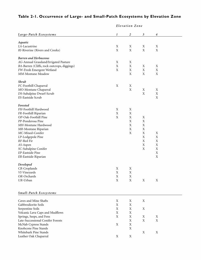
Table 2-1. Occurrence of Large- and Small-Patch Ecosystems by Elevation Zone
E l e v a t i o n Z o n e
Large-Patch Ecosy stems 1 2 3 4
AquaticLA-Lacustrine X X X XRI-Riverine (Rivers and Creeks) X X X X
Barren and HerbaceousAG-Annual Grassland/Irrigated Pasture X XBA-Barren (Cliffs, rock outcrops, diggings) X X X XFW-Fresh Emergent Wetland X X X XMM-Montane Meadow X X X
ShrubFC-Foothill Chaparral X XMO-Montane Chaparral X X XDS-Subalpine Dwarf-Scrub X XES-Eastside Scrub X
ForestedFH-Foothill Hardwood X XFR-Foothill Riparian X XOP-Oak-Foothill Pine X X XPP-Ponderosa Pine X XMH-Montane Hardwood X XMR-Montane Riparian X XMC-Mixed-Conifer X X XLP-Lodgepole Pine X XRF-Red Fir X XAS-Aspen X XSC-Subalpine Conifer X XEP-Eastside Pine XER-Eastside Riparian X
DevelopedCR-Croplands X XVI-Vineyards X XOR-Orchards X XUR-Urban X X X X
Small-Patch Ecosy stems
Caves and Mine Shafts X X XGabbrodiorite Soils X XSerpentine Soils X X XVolcanic Lava Caps and Mudflows X XSprings, Seeps, and Fens X X X XLate-Successional Conifer Forests X X XMcNab Cypress Stands X XKnobcone Pine Stands XWhitebark Pine Stands X XLeather Oak Chaparral X X
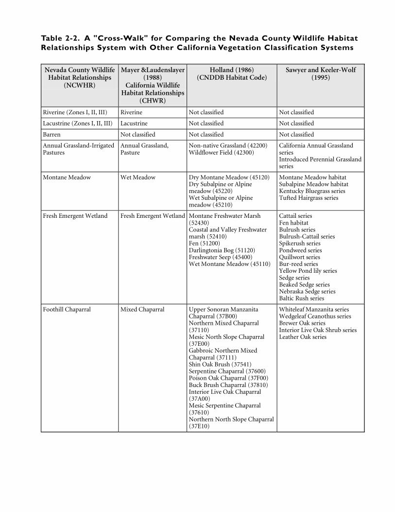
Table 2-2. A "Cross-Walk" for Comparing the Nevada County Wildlife HabitatRelationships System with Other California Vegetation Classification Systems
Nevada County Wildlife Habitat Relationships
(NCWHR)
Mayer &Laudenslayer (1988)
California Wildlife Habitat Relationships
(CHWR)
Holland (1986) (CNDDB Habitat Code)
Sawyer and Keeler-Wolf (1995)
Riverine (Zones I, II, III) Riverine Not classified Not classified
Lacustrine (Zones I, II, III) Lacustrine Not classified Not classified
Barren Not classified Not classified Not classified
Annual Grassland-Irrigated Pastures
Annual Grassland, Pasture
Non-native Grassland (42200) Wildflower Field (42300)
California Annual Grassland series Introduced Perennial Grassland series
Montane Meadow Wet Meadow Dry Montane Meadow (45120) Dry Subalpine or Alpine meadow (45220) Wet Subalpine or Alpine meadow (45210)
Montane Meadow habitat Subalpine Meadow habitat Kentucky Bluegrass series Tufted Hairgrass series
Fresh Emergent Wetland Fresh Emergent Wetland Montane Freshwater Marsh (52430) Coastal and Valley Freshwater marsh (52410) Fen (51200) Darlingtonia Bog (51120) Freshwater Seep (45400) Wet Montane Meadow (45110)
Cattail series Fen habitat Bulrush series Bulrush-Cattail series Spikerush series Pondweed series Quillwort series Bur-reed series Yellow Pond lily series Sedge series Beaked Sedge series Nebraska Sedge series Baltic Rush series
Foothill Chaparral Mixed Chaparral Upper Sonoran Manzanita Chaparral (37B00) Northern Mixed Chaparral (37110) Mesic North Slope Chaparral (37E00) Gabbroic Northern Mixed Chaparral (37111) Shin Oak Brush (37541) Serpentine Chaparral (37600) Poison Oak Chaparral (37F00) Buck Brush Chaparral (37810) Interior Live Oak Chaparral (37A00) Mesic Serpentine Chaparral (37610) Northern North Slope Chaparral (37E10)
Whiteleaf Manzanita series Wedgeleaf Ceanothus series Brewer Oak series Interior Live Oak Shrub series Leather Oak series
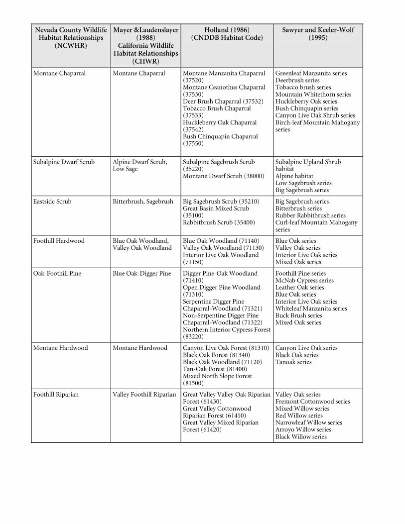
Nevada County Wildlife Habitat Relationships
(NCWHR)
Mayer &Laudenslayer (1988)
California Wildlife Habitat Relationships
(CHWR)
Holland (1986) (CNDDB Habitat Code)
Sawyer and Keeler-Wolf (1995)
Montane Chaparral Montane Chaparral Montane Manzanita Chaparral (37520) Montane Ceanothus Chaparral (37530) Deer Brush Chaparral (37532) Tobacco Brush Chaparral (37533) Huckleberry Oak Chaparral (37542) Bush Chinquapin Chaparral (37550)
Greenleaf Manzanita series Deerbrush series Tobacco brush series Mountain Whitethorn series Huckleberry Oak series Bush Chinquapin series Canyon Live Oak Shrub series Birch-leaf Mountain Mahogany series
Subalpine Dwarf Scrub Alpine Dwarf Scrub, Low Sage
Subalpine Sagebrush Scrub (35220) Montane Dwarf Scrub (38000)
Subalpine Upland Shrub habitat Alpine habitat Low Sagebrush series Big Sagebrush series
Eastside Scrub Bitterbrush, Sagebrush Big Sagebrush Scrub (35210) Great Basin Mixed Scrub (35100) Rabbitbrush Scrub (35400)
Big Sagebrush series Bitterbrush series Rubber Rabbitbrush series Curl-leaf Mountain Mahogany series
Foothill Hardwood Blue Oak Woodland, Valley Oak Woodland
Blue Oak Woodland (71140) Valley Oak Woodland (71130) Interior Live Oak Woodland (71150)
Blue Oak series Valley Oak series Interior Live Oak series Mixed Oak series
Oak-Foothill Pine Blue Oak-Digger Pine Digger Pine-Oak Woodland (71410) Open Digger Pine Woodland (71310) Serpentine Digger Pine Chaparral-Woodland (71321) Non-Serpentine Digger Pine Chaparral-Woodland (71322) Northern Interior Cypress Forest (83220)
Foothill Pine series McNab Cypress series Leather Oak series Blue Oak series Interior Live Oak series Whiteleaf Manzanita series Buck Brush series Mixed Oak series
Montane Hardwood Montane Hardwood Canyon Live Oak Forest (81310) Black Oak Forest (81340) Black Oak Woodland (71120) Tan-Oak Forest (81400) Mixed North Slope Forest (81500)
Canyon Live Oak series Black Oak series Tanoak series
Foothill Riparian Valley Foothill Riparian Great Valley Valley Oak Riparian Forest (61430) Great Valley Cottonwood Riparian Forest (61410) Great Valley Mixed Riparian Forest (61420)
Valley Oak series Fremont Cottonwood series Mixed Willow series Red Willow series Narrowleaf Willow series Arroyo Willow series Black Willow series
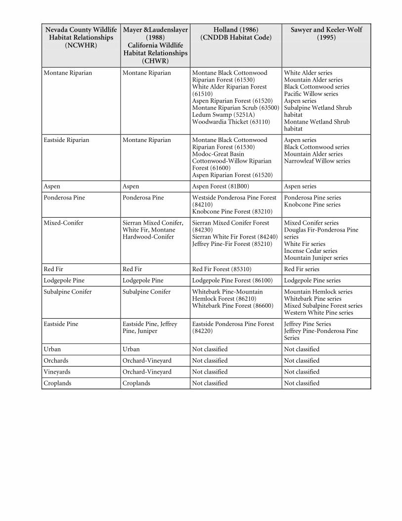
Nevada County Wildlife Habitat Relationships
(NCWHR)
Mayer &Laudenslayer (1988)
California Wildlife Habitat Relationships
(CHWR)
Holland (1986) (CNDDB Habitat Code)
Sawyer and Keeler-Wolf (1995)
Montane Riparian Montane Riparian Montane Black Cottonwood Riparian Forest (61530) White Alder Riparian Forest (61510) Aspen Riparian Forest (61520) Montane Riparian Scrub (63500) Ledum Swamp (5251A) Woodwardia Thicket (63110)
White Alder series Mountain Alder series Black Cottonwood series Pacific Willow series Aspen series Subalpine Wetland Shrub habitat Montane Wetland Shrub habitat
Eastside Riparian Montane Riparian Montane Black Cottonwood Riparian Forest (61530) Modoc-Great Basin Cottonwood-Willow Riparian Forest (61600) Aspen Riparian Forest (61520)
Aspen series Black Cottonwood series Mountain Alder series Narrowleaf Willow series
Aspen Aspen Aspen Forest (81B00) Aspen series
Ponderosa Pine Ponderosa Pine Westside Ponderosa Pine Forest (84210) Knobcone Pine Forest (83210)
Ponderosa Pine series Knobcone Pine series
Mixed-Conifer Sierran Mixed Conifer, White Fir, Montane Hardwood-Conifer
Sierran Mixed Conifer Forest (84230) Sierran White Fir Forest (84240) Jeffrey Pine-Fir Forest (85210)
Mixed Conifer series Douglas Fir-Ponderosa Pine series White Fir series Incense Cedar series Mountain Juniper series
Red Fir Red Fir Red Fir Forest (85310) Red Fir series
Lodgepole Pine Lodgepole Pine Lodgepole Pine Forest (86100) Lodgepole Pine series
Subalpine Conifer Subalpine Conifer Whitebark Pine-Mountain Hemlock Forest (86210) Whitebark Pine Forest (86600)
Mountain Hemlock series Whitebark Pine series Mixed Subalpine Forest series Western White Pine series
Eastside Pine Eastside Pine, Jeffrey Pine, Juniper
Eastside Ponderosa Pine Forest (84220)
Jeffrey Pine Series Jeffrey Pine-Ponderosa Pine Series
Urban Urban Not classified Not classified
Orchards Orchard-Vineyard Not classified Not classified
Vineyards Orchard-Vineyard Not classified Not classified
Croplands Croplands Not classified Not classified
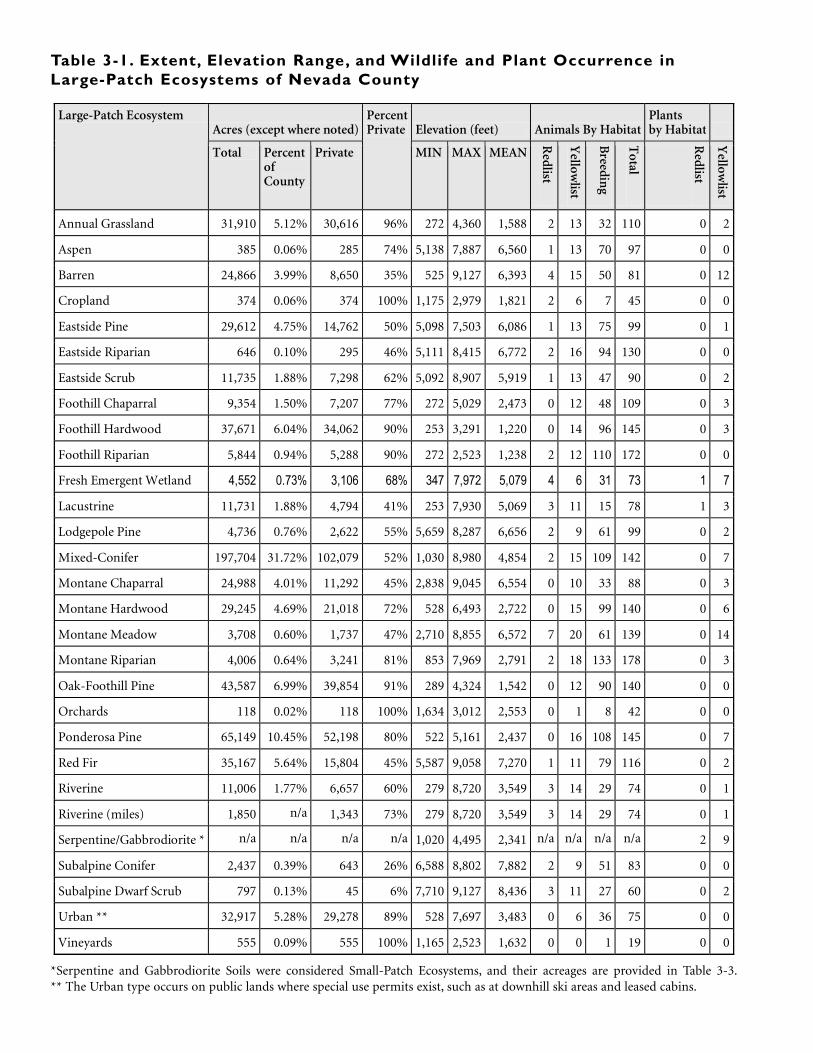
Acres (except where noted) Elevation (feet) Animals By Habitat Plants by Habitat
Large-Patch Ecosystem
Total Percent of County
Private
Percent Private
MIN MAX MEAN
Redlist
Yellow
list
Breedin
g
Total
Redlist
Yellow
list
Annual Grassland 31,910 5.12% 30,616 96% 272 4,360 1,588 2 13 32 110 0 2
Aspen 385 0.06% 285 74% 5,138 7,887 6,560 1 13 70 97 0 0
Barren 24,866 3.99% 8,650 35% 525 9,127 6,393 4 15 50 81 0 12
Cropland 374 0.06% 374 100% 1,175 2,979 1,821 2 6 7 45 0 0
Eastside Pine 29,612 4.75% 14,762 50% 5,098 7,503 6,086 1 13 75 99 0 1
Eastside Riparian 646 0.10% 295 46% 5,111 8,415 6,772 2 16 94 130 0 0
Eastside Scrub 11,735 1.88% 7,298 62% 5,092 8,907 5,919 1 13 47 90 0 2
Foothill Chaparral 9,354 1.50% 7,207 77% 272 5,029 2,473 0 12 48 109 0 3
Foothill Hardwood 37,671 6.04% 34,062 90% 253 3,291 1,220 0 14 96 145 0 3
Foothill Riparian 5,844 0.94% 5,288 90% 272 2,523 1,238 2 12 110 172 0 0
Fresh Emergent Wetland 4,552 0.73% 3,106 68% 347 7,972 5,079 4 6 31 73 1 7
Lacustrine 11,731 1.88% 4,794 41% 253 7,930 5,069 3 11 15 78 1 3
Lodgepole Pine 4,736 0.76% 2,622 55% 5,659 8,287 6,656 2 9 61 99 0 2
Mixed-Conifer 197,704 31.72% 102,079 52% 1,030 8,980 4,854 2 15 109 142 0 7
Montane Chaparral 24,988 4.01% 11,292 45% 2,838 9,045 6,554 0 10 33 88 0 3
Montane Hardwood 29,245 4.69% 21,018 72% 528 6,493 2,722 0 15 99 140 0 6
Montane Meadow 3,708 0.60% 1,737 47% 2,710 8,855 6,572 7 20 61 139 0 14
Montane Riparian 4,006 0.64% 3,241 81% 853 7,969 2,791 2 18 133 178 0 3
Oak-Foothill Pine 43,587 6.99% 39,854 91% 289 4,324 1,542 0 12 90 140 0 0
Orchards 118 0.02% 118 100% 1,634 3,012 2,553 0 1 8 42 0 0
Ponderosa Pine 65,149 10.45% 52,198 80% 522 5,161 2,437 0 16 108 145 0 7
Red Fir 35,167 5.64% 15,804 45% 5,587 9,058 7,270 1 11 79 116 0 2
Riverine 11,006 1.77% 6,657 60% 279 8,720 3,549 3 14 29 74 0 1
Riverine (miles) 1,850 n/a 1,343 73% 279 8,720 3,549 3 14 29 74 0 1
Serpentine/Gabbrodiorite * n/a n/a n/a n/a 1,020 4,495 2,341 n/a n/a n/a n/a 2 9
Subalpine Conifer 2,437 0.39% 643 26% 6,588 8,802 7,882 2 9 51 83 0 0
Subalpine Dwarf Scrub 797 0.13% 45 6% 7,710 9,127 8,436 3 11 27 60 0 2
Urban ** 32,917 5.28% 29,278 89% 528 7,697 3,483 0 6 36 75 0 0
Vineyards 555 0.09% 555 100% 1,165 2,523 1,632 0 0 1 19 0 0
Table 3-1. Extent, Elevation Range, and Wildlife and Plant Occurrence inLarge-Patch Ecosystems of Nevada County
*Serpentine and Gabbrodiorite Soils were considered Small-Patch Ecosystems, and their acreages are provided in Table 3-3.** The Urban type occurs on public lands where special use permits exist, such as at downhill ski areas and leased cabins.
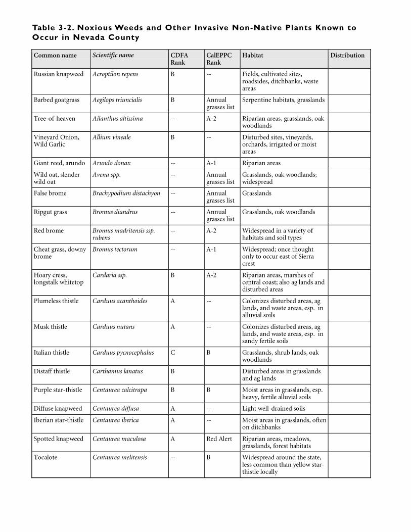
Common name Scientific name CDFA Rank
CalEPPC Rank
Habitat Distribution
Russian knapweed Acroptilon repens B -- Fields, cultivated sites, roadsides, ditchbanks, waste areas
Barbed goatgrass Aegilops triuncialis B Annual grasses list
Serpentine habitats, grasslands
Tree-of-heaven Ailanthus altissima -- A-2 Riparian areas, grasslands, oak woodlands
Vineyard Onion, Wild Garlic
Allium vineale B -- Disturbed sites, vineyards, orchards, irrigated or moist areas
Giant reed, arundo Arundo donax -- A-1 Riparian areas
Wild oat, slender wild oat
Avena spp. -- Annual grasses list
Grasslands, oak woodlands; widespread
False brome Brachypodium distachyon -- Annual grasses list
Grasslands
Ripgut grass Bromus diandrus -- Annual grasses list
Grasslands, oak woodlands
Red brome Bromus madritensis ssp. rubens
-- A-2 Widespread in a variety of habitats and soil types
Cheat grass, downy brome
Bromus tectorum -- A-1 Widespread; once thought only to occur east of Sierra crest
Hoary cress, longstalk whitetop
Cardaria ssp. B A-2
Riparian areas, marshes of central coast; also ag lands and disturbed areas
Plumeless thistle Carduus acanthoides A -- Colonizes disturbed areas, ag lands, and waste areas, esp. in alluvial soils
Musk thistle Carduus nutans A -- Colonizes disturbed areas, ag lands, and waste areas, esp. in sandy fertile soils
Italian thistle Carduus pycnocephalus C B Grasslands, shrub lands, oak woodlands
Distaff thistle Carthamus lanatus B Disturbed areas in grasslands and ag lands
Purple star-thistle Centaurea calcitrapa B B Moist areas in grasslands, esp. heavy, fertile alluvial soils
Diffuse knapweed Centaurea diffusa A -- Light well-drained soils
Iberian star-thistle Centaurea iberica A -- Moist areas in grasslands, often on ditchbanks
Spotted knapweed Centaurea maculosa A Red Alert Riparian areas, meadows, grasslands, forest habitats
Tocalote Centaurea melitensis -- B Widespread around the state, less common than yellow star-thistle locally
Table 3-2. Noxious Weeds and Other Invasive Non-Native Plants Known toOccur in Nevada County
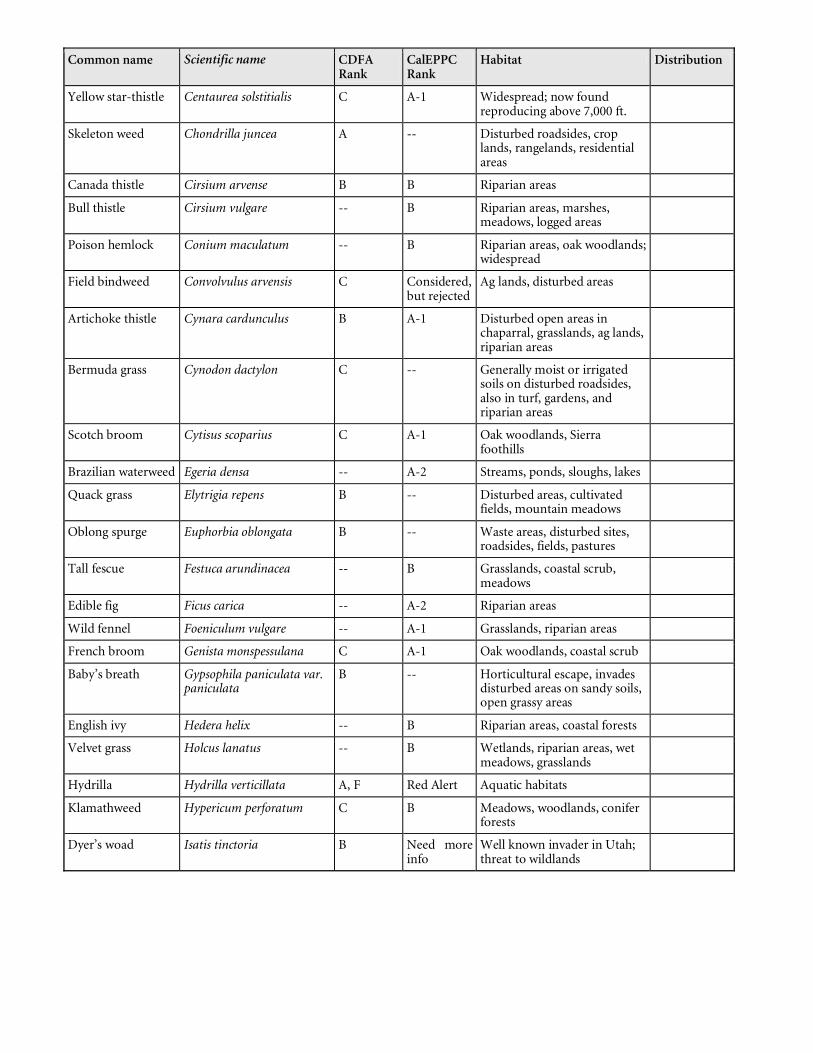
Common name Scientific name CDFA Rank
CalEPPC Rank
Habitat Distribution
Yellow star-thistle Centaurea solstitialis C A-1 Widespread; now found reproducing above 7,000 ft.
Skeleton weed Chondrilla juncea A -- Disturbed roadsides, crop lands, rangelands, residential areas
Canada thistle Cirsium arvense B B Riparian areas
Bull thistle Cirsium vulgare -- B Riparian areas, marshes, meadows, logged areas
Poison hemlock Conium maculatum -- B Riparian areas, oak woodlands; widespread
Field bindweed Convolvulus arvensis C Considered, but rejected
Ag lands, disturbed areas
Artichoke thistle Cynara cardunculus B A-1
Disturbed open areas in chaparral, grasslands, ag lands, riparian areas
Bermuda grass Cynodon dactylon C -- Generally moist or irrigated soils on disturbed roadsides, also in turf, gardens, and riparian areas
Scotch broom Cytisus scoparius C A-1 Oak woodlands, Sierra foothills
Brazilian waterweed Egeria densa -- A-2 Streams, ponds, sloughs, lakes
Quack grass Elytrigia repens B -- Disturbed areas, cultivated fields, mountain meadows
Oblong spurge Euphorbia oblongata B -- Waste areas, disturbed sites, roadsides, fields, pastures
Tall fescue Festuca arundinacea -- B Grasslands, coastal scrub, meadows
Edible fig Ficus carica -- A-2 Riparian areas
Wild fennel Foeniculum vulgare -- A-1 Grasslands, riparian areas
French broom Genista monspessulana C A-1 Oak woodlands, coastal scrub
Baby’s breath Gypsophila paniculata var. paniculata
B -- Horticultural escape, invades disturbed areas on sandy soils, open grassy areas
English ivy Hedera helix -- B Riparian areas, coastal forests
Velvet grass Holcus lanatus -- B Wetlands, riparian areas, wet meadows, grasslands
Hydrilla Hydrilla verticillata A, F Red Alert Aquatic habitats
Klamathweed Hypericum perforatum C B Meadows, woodlands, conifer forests
Dyer’s woad Isatis tinctoria B Need more info
Well known invader in Utah; threat to wildlands
Common name Scientific name CDFA Rank
CalEPPC Rank
Habitat Distribution
Perennial pepperweed, tall whitetop
Lepidium latifolium B A-1 Coastal and inland marshes, riparian areas, wetlands, grasslands
Ox-eye daisy Leucanthemum vulgare -- B Grasslands, mountain meadows
Toadflax Linaria genistifolia ssp. Dalmatica
A -- Disturbed open areas, fields, pastures, degraded rangelands, roadsides, crop lands
Italian ryegrass Lolium multiflorum -- Annual grasses list
Grasslands, wetlands, vernal pools
Purple loosestrife Lythrum salicaria B Red alert
Horticultural; noxious weed of wetlands, riparian areas
Pennyroyal Mentha pulegium -- A-2 Wetlands, vernal pools
Nimblewell Muhlenbergia schreberi B -- Turf weed, also in pastures, orchards, forest sites, residential areas, moist woodlands
Parrot’s feather Myriophyllum aquaticum -- B Streams, lakes, ponds
Eurasian milfoil Myriophyllum spicatum -- A-1 Lakes, ponds, streams
Olive Olea europaea -- B
Horticulturtal/agricultural escape; reported as invasive in riparian habitats
Scotch thistle Onopordum acanthium ssp. acanthium
A -- Natural areas, disturbed areas, roadsides, fields, esp. fertile soils
Taurian cottonthistle
Onopordum tauricum A -- Natural areas, disturbed areas, roadsides, fields, esp. fertile soils
Bulbous canarygrass
Phalaris aquatica -- B
Moist soils, wetland and riparian areas, meadows
Japanese knotweed Polygonum cuspidatum B -- Horticultural escape, invades riparian and wetland areas, esp. bare volcanics
Giant knotweed Polygonum sachalinense B -- Horticultural escape, invades riparian and wetland areas, esp. open, sunny sites
Black locust Robinia pseudoacacia -- B Riparian areas, canyons
Himalayan blackberry
Rubus discolor -- A-1 Riparian areas, marshes, oak woodlands, seeps and springs
Russian thistle Salsola tragus C -- Sandy soils in grasslands, desert washes, roadsides, disturbed areas, including disturbed natural areas; throughout CA
Bouncing-bet Saponaria officinalis -- A-2 Riparian areas, meadows
Common name Scientific name CDFA Rank
CalEPPC Rank
Habitat Distribution
Peruvian pepper tree
Schinus molle -- B
Horticultural species, invasive in riparian habitats
Tansy ragwort Senecio jacobaea B B
Grasslands, disturbed areas, waste places, roadsides
Carolina horsenettle
Solanum carolinense B -- Disturbed areas, degraded ag lands, pastures, esp. sandy well-drained soils
White horsenettle Solanum elaeagnifolium B -- Disturbed areas, ag lands, roadsides, vineyards, forest openings, waste areas
Johnsongrass Sorghum halepense C -- Ditchbanks, moist areas in orchards and pastures, roadsides
Medusa-head Taeniatherum caput-medusae
C A-1 Grasslands, including serpentine and gabbro habitats
Tamarisk, salt cedar Tamarix spp. -- A-1 Riparian areas, desert washes, seeps and springs
Puncture vine Tribulus terrestris C -- Sandy soils in grasslands, disturbed areas, waste areas,
Common gorse Ulex europaeus B -- Disturbed areas, logged areas, burn sites, ag lands
Woolly mullein Verbascum thapsus -- B Meadows, woodlands, riparian areas, burn sites
Periwinkle Vinca major -- B Riparian areas, oak woodlands
1 California Exotic Pest Plant Council Lists: A-1 = Most Invasive Wildland Pest Plants, Widespread; A-2 = Most Invasive Wildland Pests, Regional; B = Wildland Pest Plants of Lesser Invasiveness; Need More Information = Species’ status is uncertain; more information is needed; Red Alert = Pest plants with the potential to spread explosively; Annual Grass = a preliminary list of annual grasses, abundant and widespread in California, that pose significant threats to wildlands.
2 California Department of Food and Agriculture Lists: F = Federal Noxious Weed, as designated by USDA; targeted for federally-funded prevention, eradication, or containment efforts; A = The agency mandates that these species be targeted for eradication or containment; B = These species are more widespread and, therefore, difficult to contain and the agency allows county Agricultural Commissioners to decide whether to target them for eradication or containment in their jurisdictions; C = These weeds are so widespread that the agency does not endorse state- or county-funded eradication or containment efforts except in nurseries or seed lots.
Table 3-3: Extent, Percent Private and Elevation Range of Small-PatchEcosystems in Nevada County
Elevation (feet) Small Patch Ecosystem Type Acres Percent of County
Private Acres
Total Locations
Private Locations
Percent Private
MIN MAX MEAN
Caves and Mine Shafts 209 168 80.4% 600 7,382 3,335
Gabbrodiorite Soils 9,903 1.59% 8,622 87.1% 1,191 3,671 2,471
Knobcone Pine Stands 74 0.01% 13 17.1% 2,457 3,602 2,822
Late-Successional and Old-growth Mixed-Conifer Stands
847 0.14% 127 15.0% 1,772 4,898 3,876
Late-Successional and Old-growth Red Fir Stands
3,203 0.51% 956 29.8% 6,348 8,573 7,519
Lava Caps and Volcanic Mudflows
73 0.01% 70 95.3% 2,369 2,982 2,640
Leather Oak Chaparral Stands 197 0.03% 170 86.3% 2,175 2,703 2,427
McNab Cypress Stands 174 0.03% 123 70.9% 2,008 3,110 2,449
Serpentine Soils 4,553 0.73% 3,199 70.3% 1,020 4,495 2,753
Springs, Seeps and Fens 85 58 68.2% 682 6,604 3,781
Valley Oak Woodland 1,804 0.29% 1,702 94.4% 338 2,300 1,456
Whitebark Pine Stands 32 0.01% 0 0.0% 8,651 9,009 8,799
Table IX-I: Acreages of Large-Patch Ecosystems in Nevada County
Large-Patch Ecosystem Type (acres) NAME
Acres Zone Annual Grassland
Aspen
Barren Cropland
Eastside Pine Eastside Riparian
Eastside Scrub Foothill Chaparral
Foothill Hardwood Foothill Riparian Fresh Em
ergent Wetland
Lacustrine
Lodgepole Pine
Mixed-Conifer
Montane Hardwood
Montane Meadow
Montane Oak Montane Riparian
Oak-Foothill Pine Orchards
Ponderosa Pine
Red Fir Riverine Subalpine Dwarf Scrub SubalpineConifer
Urban Vineyards
Bald Rock Mountain 2,976 1 535 0 5 0 0 0 0 0 716 157 1 0 0 0 0 182 0 0 1303 0 5 0 48 0 0 0 0Camp Far West Reservoir 2,036 1 192 0 0 0 0 0 0 8 1520 69 20 27 0 0 0 0 0 0 129 0 0 0 10 0 0 0 0Dempsey Creek 1,710 1 316 0 0 0 0 0 0 9 1176 44 8 0 0 0 0 0 0 0 170 0 0 0 2 0 0 0 0Excelsior 7,700 1 731 0 15 39 0 0 0 34 1154 203 11 23 0 0 0 354 0 58 2098 0 597 0 65 0 0 2041 0Indian Springs Creek 7,744 1 2273 0 0 6 0 0 0 47 1450 356 58 8 0 0 0 148 0 0 2964 0 127 0 48 0 0 0 251Little Dry Creek 6,652 1 648 0 0 0 0 0 0 2 4106 373 9 2 0 0 0 3 0 0 1405 0 9 0 55 0 0 56 0Rock Creek (Bear R) 6,688 1 1335 0 77 0 0 0 0 134 3305 267 47 4 0 0 0 8 0 0 1495 0 3 0 59 0 0 11 0Slacks Ravine 3,317 1 195 0 0 0 0 0 0 8 1980 134 13 0 0 0 0 33 0 0 805 0 16 0 24 0 0 120 0Spenceville 5,860 1 1160 0 0 0 0 0 0 0 3243 374 72 0 0 0 0 4 0 0 1009 0 5 0 41 0 0 0 0Squirrel Creek 6,705 1 2014 0 0 0 0 0 0 20 608 254 1 0 0 0 0 72 0 0 3014 0 633 0 64 0 0 87 185Sugarloaf Mtn. 6,368 1 2242 0 0 8 0 0 0 7 669 306 58 16 0 0 0 166 0 0 2628 0 305 0 48 0 0 31 0Tarr Ditch 5,794 1 1201 0 0 16 0 0 0 570 410 237 14 10 0 0 0 156 0 0 2542 0 434 0 44 0 0 82 0Vineyard Creek 4,084 1 336 0 0 0 0 0 0 0 3264 188 105 0 0 0 0 0 0 0 217 0 0 0 39 0 0 0 0Wolf Creek 9,185 1 3853 0 0 40 0 0 0 21 2993 281 109 13 0 0 0 27 0 0 1710 0 12 0 89 0 0 8 5Woods Creek 4,597 1 979 0 0 0 0 0 0 0 1486 120 0 53 0 0 0 1 0 0 1456 0 201 0 28 0 0 6 0Blind Shady Creek 9,285 2 582 0 417 0 0 0 0 707 74 39 68 12 0 1005 0 1377 0 317 566 5 3931 0 96 0 0 98 3Campbell Creek 2,159 2 70 0 0 0 0 0 0 64 182 0 2 0 0 0 0 538 0 105 168 0 895 0 43 0 0 105 0Cedar Ravine 8,083 2 517 0 0 0 0 0 0 79 554 0 7 0 0 10 0 1331 0 271 1108 0 2706 0 86 0 0 1465 0Clear Creek 4,985 2 1201 0 13 98 0 0 0 684 205 263 9 8 0 0 0 246 0 0 1462 0 673 0 45 0 0 8 82Colgate Powerhouse 2,455 2 7 0 23 0 0 0 0 14 521 133 0 8 0 0 0 179 0 0 908 0 577 0 33 0 0 0 0
Large-Patch Ecosystem Type (acres) NAME
Acres Zone Annual Grassland
Aspen
Barren Cropland
Eastside Pine Eastside Riparian
Eastside Scrub Foothill Chaparral
Foothill Hardwood Foothill Riparian Fresh Em
ergent Wetland
Lacustrine
Lodgepole Pine
Mixed-Conifer
Montane Hardwood
Montane Meadow
Montane Oak Montane Riparian
Oak-Foothill Pine Orchards
Ponderosa Pine
Red Fir Riverine Subalpine Dwarf Scrub SubalpineConifer
Urban Vineyards
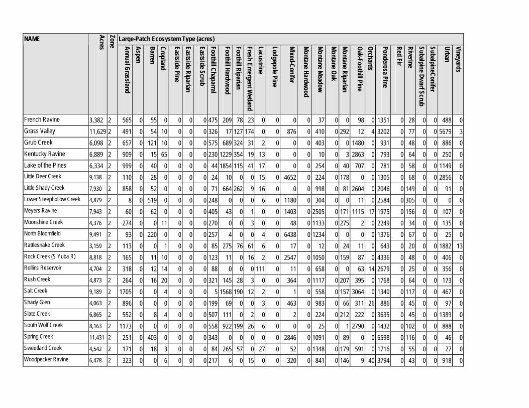
French Ravine 3,382 2 565 0 55 0 0 0 0 475 209 78 23 0 0 0 0 37 0 0 98 0 1351 0 28 0 0 488 0Grass Valley 11,629 2 491 0 54 10 0 0 0 326 17 127 174 0 0 876 0 410 0 292 12 4 3202 0 77 0 0 5679 3Grub Creek 6,098 2 657 0 121 10 0 0 0 575 689 324 31 2 0 0 0 403 0 0 1480 0 931 0 48 0 0 886 0Kentucky Ravine 6,889 2 909 0 15 65 0 0 0 230 1229 354 19 13 0 0 0 10 0 3 2863 0 793 0 64 0 0 250 0Lake of the Pines 6,334 2 999 0 40 0 0 0 0 44 1854 115 41 17 0 0 0 254 0 40 707 0 781 0 58 0 0 1149 0Little Deer Creek 9,138 2 110 0 28 0 0 0 0 24 10 0 0 15 0 4652 0 224 0 178 0 0 1305 0 68 0 0 2856 0Little Shady Creek 7,930 2 858 0 52 0 0 0 0 71 664 262 9 16 0 0 0 998 0 81 2604 0 2046 0 149 0 0 91 0Lower Steephollow Creek 4,879 2 8 0 519 0 0 0 0 248 0 0 0 6 0 1180 0 304 0 0 11 0 2584 0 305 0 0 0 0Meyers Ravine 7,943 2 60 0 62 0 0 0 0 405 43 0 1 0 0 1403 0 2505 0 171 1115 17 1975 0 156 0 0 107 0Moonshine Creek 4,376 2 274 0 0 11 0 0 0 270 0 0 3 0 0 48 0 1133 0 275 2 0 2249 0 34 0 0 135 0North Bloomfield 9,491 2 93 0 220 0 0 0 0 257 4 0 0 4 0 6438 0 1234 0 0 0 0 1376 0 67 0 0 25 0Rattlesnake Creek 3,159 2 113 0 0 1 0 0 0 85 275 76 61 6 0 17 0 12 0 24 11 0 643 0 20 0 0 1882 13Rock Creek (S Yuba R) 8,818 2 165 0 11 10 0 0 0 123 11 0 16 2 0 2547 0 1050 0 159 87 0 4336 0 48 0 0 406 0Rollins Reservoir 4,704 2 318 0 12 14 0 0 0 88 0 0 0 111 0 11 0 658 0 0 63 14 2679 0 25 0 0 356 0Rush Creek 4,873 2 264 0 16 20 0 0 0 321 145 28 3 0 0 364 0 1117 0 207 395 0 1768 0 64 0 0 173 0Salt Creek 9,189 2 1705 0 0 4 0 0 0 5 1568 190 12 2 0 1 0 558 0 157 3064 0 1340 0 117 0 0 467 0Shady Glen 4,063 2 896 0 0 0 0 0 0 199 69 0 0 3 0 463 0 983 0 66 311 26 886 0 45 0 0 97 0Slate Creek 6,865 2 552 0 8 4 0 0 0 507 111 0 2 0 0 2 0 224 0 212 222 0 3635 0 45 0 0 1389 0South Wolf Creek 8,163 2 1173 0 0 0 0 0 0 558 922 199 26 6 0 0 0 25 0 1 2790 0 1432 0 102 0 0 888 0Spring Creek 11,431 2 251 0 403 0 0 0 0 343 0 0 0 0 0 2846 0 1091 0 89 0 0 6598 0 116 0 0 46 0Sweetland Creek 4,542 2 171 0 18 3 0 0 0 84 265 57 0 27 0 52 0 1348 0 179 591 0 1716 0 55 0 0 27 0Woodpecker Ravine 6,478 2 323 0 0 6 0 0 0 217 6 0 15 0 0 320 0 841 0 146 9 40 3794 0 43 0 0 918 0
Large-Patch Ecosystem Type (acres) NAME
Acres Zone Annual Grassland
Aspen
Barren Cropland
Eastside Pine Eastside Riparian
Eastside Scrub Foothill Chaparral
Foothill Hardwood Foothill Riparian Fresh Em
ergent Wetland
Lacustrine
Lodgepole Pine
Mixed-Conifer
Montane Hardwood
Montane Meadow
Montane Oak Montane Riparian
Oak-Foothill Pine Orchards
Ponderosa Pine
Red Fir Riverine Subalpine Dwarf Scrub SubalpineConifer
Urban Vineyards
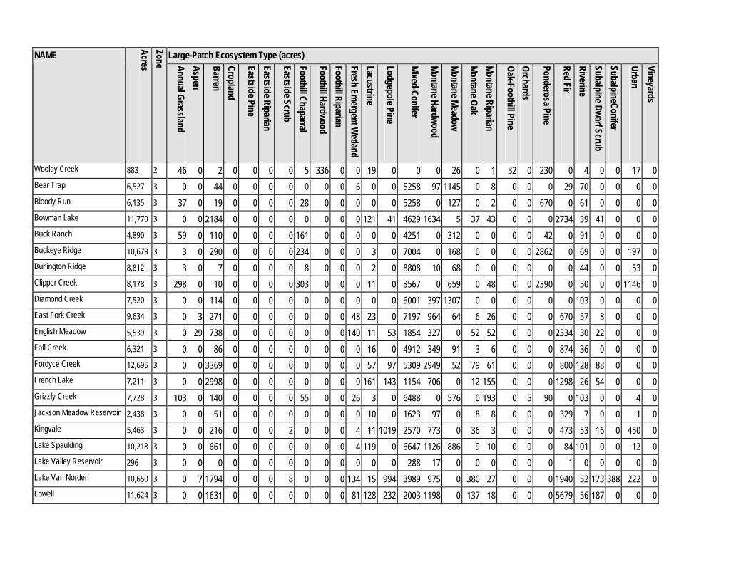
Wooley Creek 883 2 46 0 2 0 0 0 0 5 336 0 0 19 0 0 0 26 0 1 32 0 230 0 4 0 0 17 0Bear Trap 6,527 3 0 0 44 0 0 0 0 0 0 0 6 0 0 5258 97 1145 0 8 0 0 0 29 70 0 0 0 0Bloody Run 6,135 3 37 0 19 0 0 0 0 28 0 0 0 0 0 5258 0 127 0 2 0 0 670 0 61 0 0 0 0Bowman Lake 11,770 3 0 0 2184 0 0 0 0 0 0 0 0 121 41 4629 1634 5 37 43 0 0 0 2734 39 41 0 0 0Buck Ranch 4,890 3 59 0 110 0 0 0 0 161 0 0 0 0 0 4251 0 312 0 0 0 0 42 0 91 0 0 0 0Buckeye Ridge 10,679 3 3 0 290 0 0 0 0 234 0 0 0 3 0 7004 0 168 0 0 0 0 2862 0 69 0 0 197 0Burlington Ridge 8,812 3 3 0 7 0 0 0 0 8 0 0 0 2 0 8808 10 68 0 0 0 0 0 0 44 0 0 53 0Clipper Creek 8,178 3 298 0 10 0 0 0 0 303 0 0 0 11 0 3567 0 659 0 48 0 0 2390 0 50 0 0 1146 0Diamond Creek 7,520 3 0 0 114 0 0 0 0 0 0 0 0 0 0 6001 397 1307 0 0 0 0 0 0 103 0 0 0 0East Fork Creek 9,634 3 0 3 271 0 0 0 0 0 0 0 48 23 0 7197 964 64 6 26 0 0 0 670 57 8 0 0 0English Meadow 5,539 3 0 29 738 0 0 0 0 0 0 0 140 11 53 1854 327 0 52 52 0 0 0 2334 30 22 0 0 0Fall Creek 6,321 3 0 0 86 0 0 0 0 0 0 0 0 16 0 4912 349 91 3 6 0 0 0 874 36 0 0 0 0Fordyce Creek 12,695 3 0 0 3369 0 0 0 0 0 0 0 0 57 97 5309 2949 52 79 61 0 0 0 800 128 88 0 0 0French Lake 7,211 3 0 0 2998 0 0 0 0 0 0 0 0 161 143 1154 706 0 12 155 0 0 0 1298 26 54 0 0 0Grizzly Creek 7,728 3 103 0 140 0 0 0 0 55 0 0 26 3 0 6488 0 576 0 193 0 5 90 0 103 0 0 4 0Jackson Meadow Reservoir 2,438 3 0 0 51 0 0 0 0 0 0 0 0 10 0 1623 97 0 8 8 0 0 0 329 7 0 0 1 0Kingvale 5,463 3 0 0 216 0 0 0 2 0 0 0 4 11 1019 2570 773 0 36 3 0 0 0 473 53 16 0 450 0Lake Spaulding 10,218 3 0 0 661 0 0 0 0 0 0 0 4 119 0 6647 1126 886 9 10 0 0 0 84 101 0 0 12 0Lake Valley Reservoir 296 3 0 0 0 0 0 0 0 0 0 0 0 0 0 288 17 0 0 0 0 0 0 1 0 0 0 0 0Lake Van Norden 10,650 3 0 7 1794 0 0 0 8 0 0 0 134 15 994 3989 975 0 380 27 0 0 0 1940 52 173 388 222 0Lowell 11,624 3 0 0 1631 0 0 0 0 0 0 0 81 128 232 2003 1198 0 137 18 0 0 0 5679 56 187 0 0 0
Large-Patch Ecosystem Type (acres) NAME
Acres Zone Annual Grassland
Aspen
Barren Cropland
Eastside Pine Eastside Riparian
Eastside Scrub Foothill Chaparral
Foothill Hardwood Foothill Riparian Fresh Em
ergent Wetland
Lacustrine
Lodgepole Pine
Mixed-Conifer
Montane Hardwood
Montane Meadow
Montane Oak Montane Riparian
Oak-Foothill Pine Orchards
Ponderosa Pine
Red Fir Riverine Subalpine Dwarf Scrub SubalpineConifer
Urban Vineyards
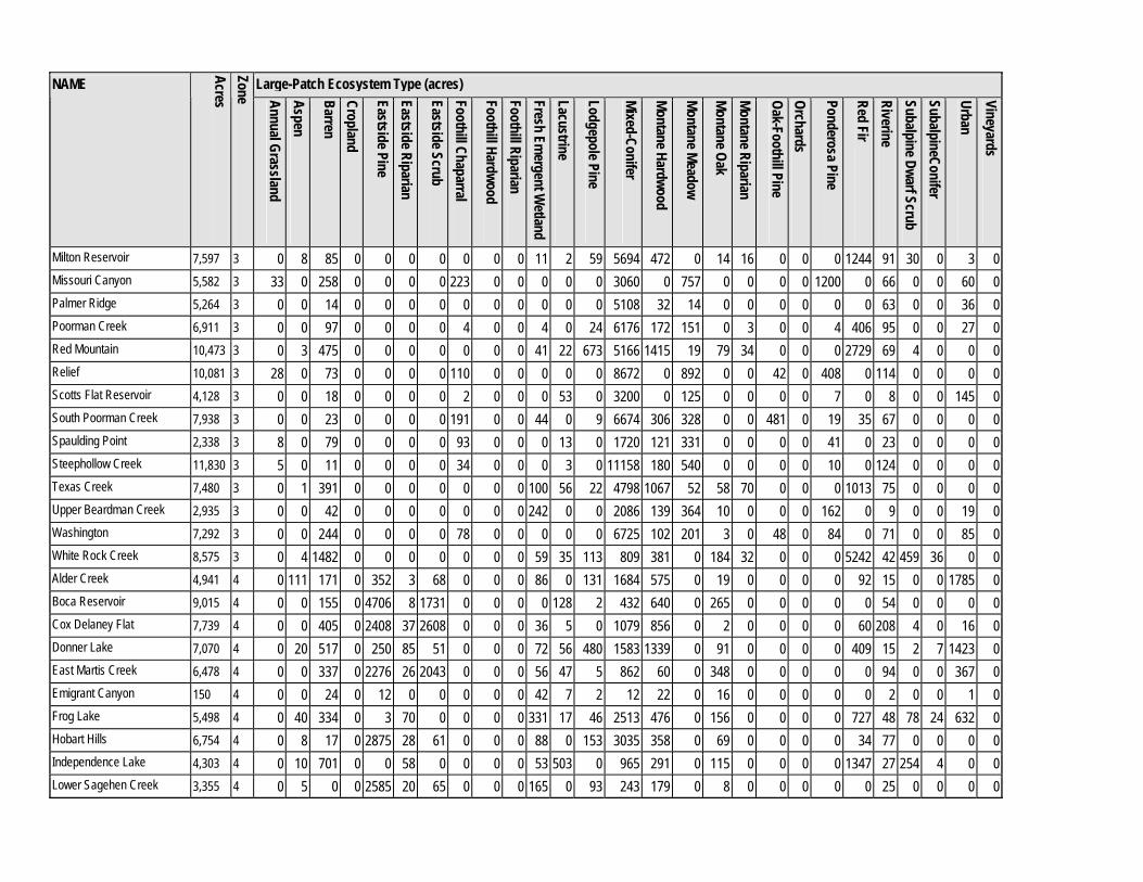
Milton Reservoir 7,597 3 0 8 85 0 0 0 0 0 0 0 11 2 59 5694 472 0 14 16 0 0 0 1244 91 30 0 3 0Missouri Canyon 5,582 3 33 0 258 0 0 0 0 223 0 0 0 0 0 3060 0 757 0 0 0 0 1200 0 66 0 0 60 0Palmer Ridge 5,264 3 0 0 14 0 0 0 0 0 0 0 0 0 0 5108 32 14 0 0 0 0 0 0 63 0 0 36 0Poorman Creek 6,911 3 0 0 97 0 0 0 0 4 0 0 4 0 24 6176 172 151 0 3 0 0 4 406 95 0 0 27 0Red Mountain 10,473 3 0 3 475 0 0 0 0 0 0 0 41 22 673 5166 1415 19 79 34 0 0 0 2729 69 4 0 0 0Relief 10,081 3 28 0 73 0 0 0 0 110 0 0 0 0 0 8672 0 892 0 0 42 0 408 0 114 0 0 0 0Scotts Flat Reservoir 4,128 3 0 0 18 0 0 0 0 2 0 0 0 53 0 3200 0 125 0 0 0 0 7 0 8 0 0 145 0South Poorman Creek 7,938 3 0 0 23 0 0 0 0 191 0 0 44 0 9 6674 306 328 0 0 481 0 19 35 67 0 0 0 0Spaulding Point 2,338 3 8 0 79 0 0 0 0 93 0 0 0 13 0 1720 121 331 0 0 0 0 41 0 23 0 0 0 0Steephollow Creek 11,830 3 5 0 11 0 0 0 0 34 0 0 0 3 0 11158 180 540 0 0 0 0 10 0 124 0 0 0 0Texas Creek 7,480 3 0 1 391 0 0 0 0 0 0 0 100 56 22 4798 1067 52 58 70 0 0 0 1013 75 0 0 0 0Upper Beardman Creek 2,935 3 0 0 42 0 0 0 0 0 0 0 242 0 0 2086 139 364 10 0 0 0 162 0 9 0 0 19 0Washington 7,292 3 0 0 244 0 0 0 0 78 0 0 0 0 0 6725 102 201 3 0 48 0 84 0 71 0 0 85 0White Rock Creek 8,575 3 0 4 1482 0 0 0 0 0 0 0 59 35 113 809 381 0 184 32 0 0 0 5242 42 459 36 0 0Alder Creek 4,941 4 0 111 171 0 352 3 68 0 0 0 86 0 131 1684 575 0 19 0 0 0 0 92 15 0 0 1785 0Boca Reservoir 9,015 4 0 0 155 0 4706 8 1731 0 0 0 0 128 2 432 640 0 265 0 0 0 0 0 54 0 0 0 0Cox Delaney Flat 7,739 4 0 0 405 0 2408 37 2608 0 0 0 36 5 0 1079 856 0 2 0 0 0 0 60 208 4 0 16 0Donner Lake 7,070 4 0 20 517 0 250 85 51 0 0 0 72 56 480 1583 1339 0 91 0 0 0 0 409 15 2 7 1423 0East Martis Creek 6,478 4 0 0 337 0 2276 26 2043 0 0 0 56 47 5 862 60 0 348 0 0 0 0 0 94 0 0 367 0Emigrant Canyon 150 4 0 0 24 0 12 0 0 0 0 0 42 7 2 12 22 0 16 0 0 0 0 0 2 0 0 1 0Frog Lake 5,498 4 0 40 334 0 3 70 0 0 0 0 331 17 46 2513 476 0 156 0 0 0 0 727 48 78 24 632 0Hobart Hills 6,754 4 0 8 17 0 2875 28 61 0 0 0 88 0 153 3035 358 0 69 0 0 0 0 34 77 0 0 0 0Independence Lake 4,303 4 0 10 701 0 0 58 0 0 0 0 53 503 0 965 291 0 115 0 0 0 0 1347 27 254 4 0 0Lower Sagehen Creek 3,355 4 0 5 0 0 2585 20 65 0 0 0 165 0 93 243 179 0 8 0 0 0 0 0 25 0 0 0 0
Large-Patch Ecosystem Type (acres) NAME
Acres Zone Annual Grassland
Aspen
Barren Cropland
Eastside Pine Eastside Riparian
Eastside Scrub Foothill Chaparral
Foothill Hardwood Foothill Riparian Fresh Em
ergent Wetland
Lacustrine
Lodgepole Pine
Mixed-Conifer
Montane Hardwood
Montane Meadow
Montane Oak Montane Riparian
Oak-Foothill Pine Orchards
Ponderosa Pine
Red Fir Riverine Subalpine Dwarf Scrub SubalpineConifer
Urban Vineyards
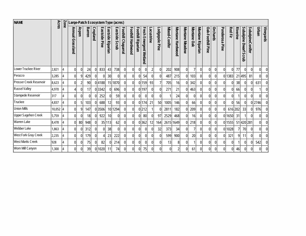
Lower Truckee River 2,821 4 0 0 24 0 833 43 738 0 0 0 0 2 0 202 908 0 7 0 0 0 0 0 77 0 0 0 0Perazzo 3,285 4 0 9 429 0 0 30 0 0 0 0 54 0 0 487 215 0 103 0 0 0 0 1383 21 495 81 0 0Prosser Creek Reservoir 8,623 4 0 2 90 0 4188 15 1870 0 0 0 159 93 7 705 16 0 342 0 0 0 0 0 38 0 0 631 0Russel Valley 4,970 4 4 0 17 0 3342 0 696 0 0 0 197 0 0 271 21 0 463 0 0 0 0 0 66 0 0 1 0Stampede Reservoir 317 4 0 0 0 0 252 0 59 0 0 0 0 0 0 1 24 0 0 0 0 0 0 0 1 0 0 0 0Truckee 4,837 4 0 5 103 0 688 12 93 0 0 0 174 21 50 1005 146 0 66 0 0 0 0 0 56 0 0 2746 0Union Mills 10,052 4 0 9 147 0 3506 10 1294 0 0 0 212 1 0 2811 182 0 209 0 0 0 0 616 202 33 0 976 0Upper Sagehen Creek 5,759 4 0 0 18 0 922 10 0 0 0 0 80 0 97 2529 468 0 16 0 0 0 0 1650 31 1 0 0 0Warren Lake 8,478 4 0 80 948 0 35 113 62 0 0 0 362 12 164 2615 1649 0 218 0 0 0 0 1555 51 420 281 0 0Webber Lake 1,863 4 0 0 312 0 0 38 0 0 0 0 0 0 32 373 34 0 7 0 0 0 0 1028 7 70 0 0 0West Fork Gray Creek 2,235 4 0 0 179 0 4 23 222 0 0 0 0 0 0 599 900 0 20 0 0 0 0 321 9 11 0 0 0West Martis Creek 928 4 0 0 75 0 82 0 214 0 0 0 0 0 0 13 8 0 1 0 0 0 0 0 1 0 0 542 0Worn Mill Canyon 1,300 4 0 0 39 0 1020 11 74 0 0 0 75 0 0 0 2 0 61 0 0 0 0 0 46 0 0 0 0
Appendix IX.Table IX-2. Nevada County Natural Resources Report 1
NAME
Zon
e
Caves an
d Min
e Shafts (n
um
ber)
Gabbrodiorite Soils (acres)
Kn
obcone P
ine Stan
ds (acres)
Late-Su
ccessional Mixed-C
onifer F
orest (acres)
Late-Su
ccessional Red F
ir Forest
(acres)
Leather O
ak Ch
aparral Stands
(acres)
McN
ab Cypress W
oodlands
(acres)
Serpentin
e Soils (acres)
Springs, Seeps an
d Fens (n
um
ber)
Valley O
ak Woodlan
ds (acres)
Volcan
ic Lava C
aps and M
udflow
s (acres)
Wh
itebark Pin
e Stands (acres)
Nevada C
oun
ty Wildlife H
abitat R
elationsh
ips Habitat T
ypes (n
um
ber of types)
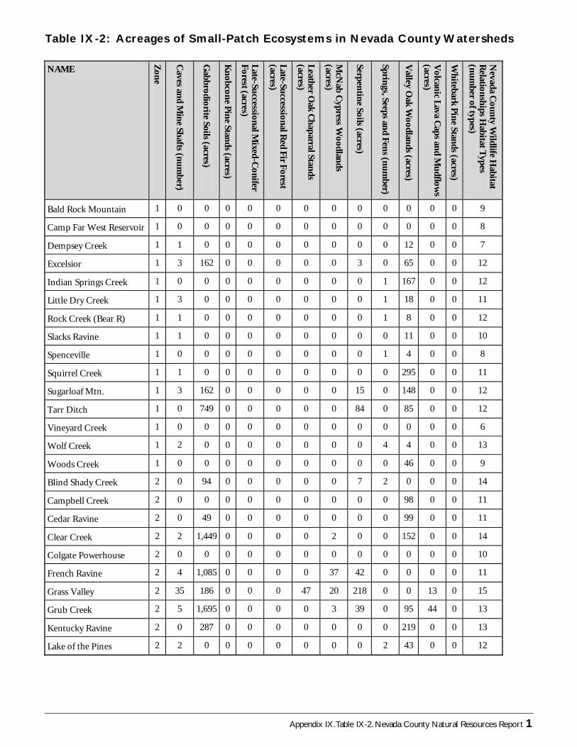
Bald Rock Mountain 1 0 0 0 0 0 0 0 0 0 0 0 0 9
Camp Far West Reservoir 1 0 0 0 0 0 0 0 0 0 0 0 0 8
Dempsey Creek 1 1 0 0 0 0 0 0 0 0 12 0 0 7
Excelsior 1 3 162 0 0 0 0 0 3 0 65 0 0 12
Indian Springs Creek 1 0 0 0 0 0 0 0 0 1 167 0 0 12
Little Dry Creek 1 3 0 0 0 0 0 0 0 1 18 0 0 11
Rock Creek (Bear R) 1 1 0 0 0 0 0 0 0 1 8 0 0 12
Slacks Ravine 1 1 0 0 0 0 0 0 0 0 11 0 0 10
Spenceville 1 0 0 0 0 0 0 0 0 1 4 0 0 8
Squirrel Creek 1 1 0 0 0 0 0 0 0 0 295 0 0 11
Sugarloaf Mtn. 1 3 162 0 0 0 0 0 15 0 148 0 0 12
Tarr Ditch 1 0 749 0 0 0 0 0 84 0 85 0 0 12
Vineyard Creek 1 0 0 0 0 0 0 0 0 0 0 0 0 6
Wolf Creek 1 2 0 0 0 0 0 0 0 4 4 0 0 13
Woods Creek 1 0 0 0 0 0 0 0 0 0 46 0 0 9
Blind Shady Creek 2 0 94 0 0 0 0 0 7 2 0 0 0 14
Campbell Creek 2 0 0 0 0 0 0 0 0 0 98 0 0 11
Cedar Ravine 2 0 49 0 0 0 0 0 0 0 99 0 0 11
Clear Creek 2 2 1,449 0 0 0 0 2 0 0 152 0 0 14
Colgate Powerhouse 2 0 0 0 0 0 0 0 0 0 0 0 0 10
French Ravine 2 4 1,085 0 0 0 0 37 42 0 0 0 0 11
Grass Valley 2 35 186 0 0 0 47 20 218 0 0 13 0 15
Grub Creek 2 5 1,695 0 0 0 0 3 39 0 95 44 0 13
Kentucky Ravine 2 0 287 0 0 0 0 0 0 0 219 0 0 13
Lake of the Pines 2 2 0 0 0 0 0 0 0 2 43 0 0 12
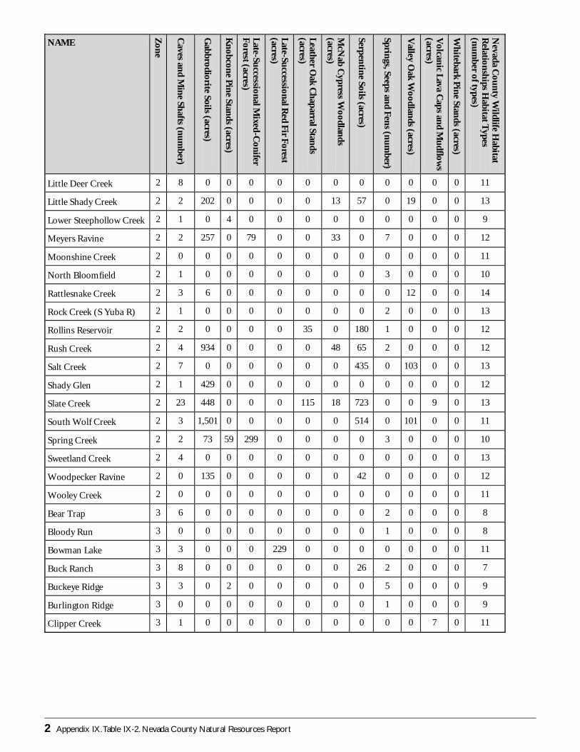
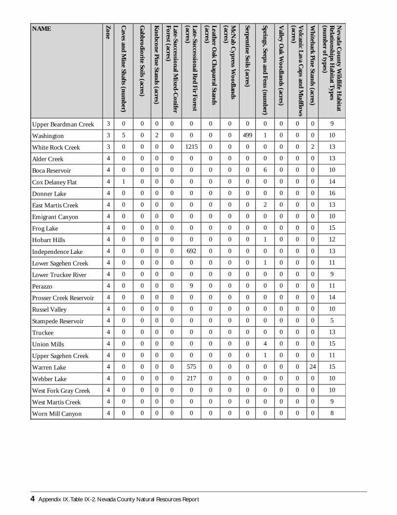
Table IX-2: Acreages of Small-Patch Ecosystems in Nevada County Watersheds
2 Appendix IX.Table IX-2. Nevada County Natural Resources Report
NAME
Zon
e
Caves an
d Min
e Shafts (n
um
ber)
Gabbrodiorite Soils (acres)
Kn
obcone P
ine Stan
ds (acres)
Late-Su
ccessional Mixed-C
onifer F
orest (acres)
Late-Su
ccessional Red F
ir Forest
(acres)
Leather O
ak Ch
aparral Stands
(acres)
McN
ab Cypress W
oodlands
(acres)
Serpentin
e Soils (acres)
Springs, Seeps an
d Fens (n
um
ber)
Valley O
ak Woodlan
ds (acres)
Volcan
ic Lava C
aps and M
udflow
s (acres)
Wh
itebark Pin
e Stands (acres)
Nevada C
oun
ty Wildlife H
abitat R
elationsh
ips Habitat T
ypes (n
um
ber of types)
Little Deer Creek 2 8 0 0 0 0 0 0 0 0 0 0 0 11
Little Shady Creek 2 2 202 0 0 0 0 13 57 0 19 0 0 13
Lower Steephollow Creek 2 1 0 4 0 0 0 0 0 0 0 0 0 9
Meyers Ravine 2 2 257 0 79 0 0 33 0 7 0 0 0 12
Moonshine Creek 2 0 0 0 0 0 0 0 0 0 0 0 0 11
North Bloomfield 2 1 0 0 0 0 0 0 0 3 0 0 0 10
Rattlesnake Creek 2 3 6 0 0 0 0 0 0 0 12 0 0 14
Rock Creek (S Yuba R) 2 1 0 0 0 0 0 0 0 2 0 0 0 13
Rollins Reservoir 2 2 0 0 0 0 35 0 180 1 0 0 0 12
Rush Creek 2 4 934 0 0 0 0 48 65 2 0 0 0 12
Salt Creek 2 7 0 0 0 0 0 0 435 0 103 0 0 13
Shady Glen 2 1 429 0 0 0 0 0 0 0 0 0 0 12
Slate Creek 2 23 448 0 0 0 115 18 723 0 0 9 0 13
South Wolf Creek 2 3 1,501 0 0 0 0 0 514 0 101 0 0 11
Spring Creek 2 2 73 59 299 0 0 0 0 3 0 0 0 10
Sweetland Creek 2 4 0 0 0 0 0 0 0 0 0 0 0 13
Woodpecker Ravine 2 0 135 0 0 0 0 0 42 0 0 0 0 12
Wooley Creek 2 0 0 0 0 0 0 0 0 0 0 0 0 11
Bear Trap 3 6 0 0 0 0 0 0 0 2 0 0 0 8
Bloody Run 3 0 0 0 0 0 0 0 0 1 0 0 0 8
Bowman Lake 3 3 0 0 0 229 0 0 0 0 0 0 0 11
Buck Ranch 3 8 0 0 0 0 0 0 26 2 0 0 0 7
Buckeye Ridge 3 3 0 2 0 0 0 0 0 5 0 0 0 9
Burlington Ridge 3 0 0 0 0 0 0 0 0 1 0 0 0 9
Clipper Creek 3 1 0 0 0 0 0 0 0 0 0 7 0 11
Stat
isti
cs b
y W
ater
shed
N
ame
Zone
Canals (total miles)
Contiguous Unimproved Tracts Greater Than 80 Acres (total acres)
Elevation (mean, in feet)
Arable Lands from NID (total acres)
Irrigated Lands from NID (total acres)
Parcel size in streamside zone (mean, in acres)
Private Lands (total acres)
Public Lands (total acres)
Slope Steepness (percentrise, mean)
Dams (total number)
Roads in the Streamside Zone (total miles)
Redlist and Yellowlist Plants and Animals (species/watershed)
App
endi
x IX
.Tab
le IX
-2.N
evad
a C
ount
y N
atur
al R
esou
rces
Rep
ort 3
NA
ME
Zone
Caves and Mine Shafts (number)
Gabbrodiorite Soils (acres)
Knobcone Pine Stands (acres)
Late-Successional Mixed-Conifer Forest (acres)
Late-Successional Red Fir Forest (acres)
Leather Oak Chaparral Stands (acres)
McNab Cypress Woodlands (acres)
Serpentine Soils (acres)
Springs, Seeps and Fens (number)
Valley Oak Woodlands (acres)
Volcanic Lava Caps and Mudflows (acres)
Whitebark Pine Stands (acres)
Nevada County Wildlife Habitat Relationships Habitat Types (number of types)
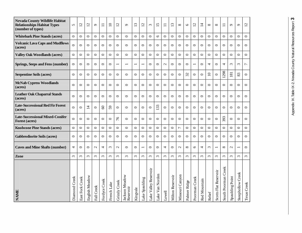
Dia
mon
d C
reek
3
4 0
0 0
0 0
0 0
0 0
0 0
5
Eas
t Fo
rk C
reek
3
0 0
0 0
0 0
0 0
0 0
0 0
12
En
glis
h M
eado
w
3 0
0 0
0 14
0
0 0
0 0
0 0
12
Fall
Cre
ek
3 2
0 0
0 0
0 0
0 0
0 0
0 9
Ford
yce
Cre
ek
3 4
0 0
0 60
0
0 0
0 0
0 0
11
Fren
ch L
ake
3 3
0 0
0 59
0
0 0
0 0
0 0
10
Gri
zzly
Cre
ek
3 2
0 0
76
0 0
0 0
1 0
0 0
12
Jack
son
Mea
dow
R
eser
voir
3
0 0
0 0
0 0
0 0
1 0
0 0
9
Kin
gval
e 3
0 0
0 0
0 0
0 0
1 0
0 0
13
Lake
Spa
uld
ing
3 1
0 0
0 0
0 0
0 1
0 0
0 12
Lake
Val
ley
Res
ervo
ir
3 0
0 0
0 0
0 0
0 0
0 0
0 3
Lake
Van
Nor
den
3
0 0
0 0
133
0 0
0 0
0 0
6 15
Low
ell
3 4
0 0
0 0
0 0
0 2
0 0
0 11
Milt
on R
eser
voir
3
0 0
0 0
0 0
0 0
0 0
0 0
13
Mis
sou
ri C
anyo
n
3 2
0 7
0 0
0 0
0 0
0 0
0 8
Pal
mer
Rid
ge
3 8
0 0
0 0
0 0
32
0 0
0 0
6
Poo
rman
Cre
ek
3 6
0 0
0 0
0 0
0 1
0 0
0 12
Red
Mou
nta
in
3 4
0 0
0 0
0 0
0 0
0 0
0 14
Rel
ief
3 3
0 0
0 0
0 0
10
4 0
0 0
8
Scot
ts F
lat R
eser
voir
3
1 0
0 0
0 0
0 0
0 0
0 0
8
Sou
th P
oorm
an C
reek
3
8 0
0 39
3 0
0 0
1298
4
0 0
0 11
Spau
ldin
g P
oin
t 3
2 0
0 0
0 0
0 18
1 3
0 0
0 9
Stee
phol
low
Cre
ek
3 1
0 0
0 0
0 0
83
3 0
0 0
9
Tex
as C
reek
3
0 0
0 0
0 0
0 0
7 0
0 0
12
4 Appendix IX.Table IX-2. Nevada County Natural Resources Report
NAME
Zon
e
Caves an
d Min
e Shafts (n
um
ber)
Gabbrodiorite Soils (acres)
Kn
obcone P
ine Stan
ds (acres)
Late-Su
ccessional Mixed-C
onifer F
orest (acres)
Late-Su
ccessional Red F
ir Forest
(acres)
Leather O
ak Ch
aparral Stands
(acres)
McN
ab Cypress W
oodlands
(acres)
Serpentin
e Soils (acres)
Springs, Seeps an
d Fens (n
um
ber)
Valley O
ak Woodlan
ds (acres)
Volcan
ic Lava C
aps and M
udflow
s (acres)
Wh
itebark Pin
e Stands (acres)
Nevada C
oun
ty Wildlife H
abitat R
elationsh
ips Habitat T
ypes (n
um
ber of types)
Upper Beardman Creek 3 0 0 0 0 0 0 0 0 0 0 0 0 9
Washington 3 5 0 2 0 0 0 0 499 1 0 0 0 10
White Rock Creek 3 0 0 0 0 1215 0 0 0 0 0 0 2 13
Alder Creek 4 0 0 0 0 0 0 0 0 0 0 0 0 13
Boca Reservoir 4 0 0 0 0 0 0 0 0 6 0 0 0 10
Cox Delaney Flat 4 1 0 0 0 0 0 0 0 0 0 0 0 14
Donner Lake 4 0 0 0 0 0 0 0 0 0 0 0 0 16
East Martis Creek 4 0 0 0 0 0 0 0 0 2 0 0 0 13
Emigrant Canyon 4 0 0 0 0 0 0 0 0 0 0 0 0 10
Frog Lake 4 0 0 0 0 0 0 0 0 0 0 0 0 15
Hobart Hills 4 0 0 0 0 0 0 0 0 1 0 0 0 12
Independence Lake 4 0 0 0 0 692 0 0 0 0 0 0 0 13
Lower Sagehen Creek 4 0 0 0 0 0 0 0 0 1 0 0 0 11
Lower Truckee River 4 0 0 0 0 0 0 0 0 0 0 0 0 9
Perazzo 4 0 0 0 0 9 0 0 0 0 0 0 0 11
Prosser Creek Reservoir 4 0 0 0 0 0 0 0 0 0 0 0 0 14
Russel Valley 4 0 0 0 0 0 0 0 0 0 0 0 0 10
Stampede Reservoir 4 0 0 0 0 0 0 0 0 0 0 0 0 5
Truckee 4 0 0 0 0 0 0 0 0 0 0 0 0 13
Union Mills 4 0 0 0 0 0 0 0 0 4 0 0 0 15
Upper Sagehen Creek 4 0 0 0 0 0 0 0 0 1 0 0 0 11
Warren Lake 4 0 0 0 0 575 0 0 0 0 0 0 24 15
Webber Lake 4 0 0 0 0 217 0 0 0 0 0 0 0 10
West Fork Gray Creek 4 0 0 0 0 0 0 0 0 0 0 0 0 10
West Martis Creek 4 0 0 0 0 0 0 0 0 0 0 0 0 9
Worn Mill Canyon 4 0 0 0 0 0 0 0 0 0 0 0 0 8
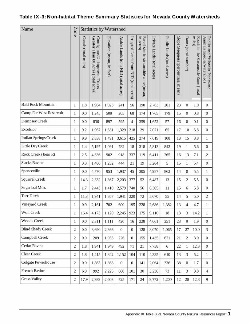
Appendix IX.Table IX-3. Nevada County Natural Resources Report 1
Statistics by Watershed Name
Zon
e Can
als (total miles)
Con
tiguou
s Un
improved T
racts G
reater Than
80 Acres (total acres)
Elevation (m
ean, in feet)
Arable Lan
ds from N
ID (total acres)
Irrigated Lands from
NID
(total acres)
Parcel size in stream
side zone (m
ean,
in acres)
Private Lan
ds (total acres)
Pu
blic Lands (total acres)
Slope Steepness (percen
trise, mean)
Dam
s (total num
ber)
Roads in the Stream
side Zone (total
miles)
Redlist an
d Yellow
list Plants an
d A
nim
als (species/watershed)
Bald Rock Mountain 1 1.8 1,984 1,023 241 56 190 2,763 201 23 0 1.0 0
Camp Far West Reservoir 1 0.0 1,245 509 205 68 174 1,765 179 15 0 0.8 0
Dempsey Creek 1 0.0 836 897 595 4 359 1,652 57 16 0 0.1 0
Excelsior 1 9.2 1,967 1,531 1,329 218 29 7,071 65 17 10 5.8 0
Indian Springs Creek 1 9.9 2,838 1,491 3,615 425 274 7,619 108 13 15 3.8 1
Little Dry Creek 1 1.4 5,197 1,091 782 18 318 5,813 842 19 1 5.6 0
Rock Creek (Bear R) 1 2.5 4,336 902 918 337 119 6,411 265 16 13 7.1 2
Slacks Ravine 1 3.3 1,486 1,232 444 21 19 3,264 5 15 1 5.4 0
Spenceville 1 0.0 4,770 953 1,937 45 305 4,987 862 14 0 5.5 1
Squirrel Creek 1 14.3 2,332 1,367 2,203 377 52 6,487 13 15 2 5.5 0
Sugarloaf Mtn. 1 1.7 2,443 1,410 2,579 740 56 6,305 11 15 6 5.8 0
Tarr Ditch 1 11.3 1,941 1,867 1,941 220 72 5,670 55 14 5 5.0 2
Vineyard Creek 1 0.9 2,161 702 600 195 228 2,686 1,382 13 4 4.7 1
Wolf Creek 1 16.4 4,173 1,120 2,245 923 175 9,110 18 13 3 14.2 1
Woods Creek 1 0.0 2,311 1,111 420 16 228 4,061 251 23 9 1.9 0
Blind Shady Creek 2 0.0 3,690 2,366 0 0 128 8,070 1,065 17 27 10.0 3
Campbell Creek 2 0.0 209 1,955 226 0 155 1,435 671 21 2 3.0 0
Cedar Ravine 2 1.8 1,941 1,949 492 71 21 7,758 6 22 1 12.3 0
Clear Creek 2 1.8 1,415 1,842 1,152 104 110 4,335 610 13 3 5.2 1
Colgate Powerhouse 2 0.0 1,865 1,363 0 0 141 2,064 336 38 0 1.7 0
French Ravine 2 6.9 992 2,225 660 101 30 3,236 73 11 3 3.8 4
Grass Valley 2 17.9 2,939 2,603 725 171 24 9,772 1,200 12 20 12.8 9
Table IX-3: Non-habitat Theme Summary Statistics for Nevada County Watersheds
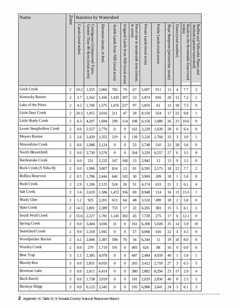
2 Appendix IX.Table IX-3. Nevada County Natural Resources Report
Statistics by Watershed Name
Zon
e Can
als (total miles)
Con
tiguou
s Un
improved T
racts G
reater Than
80 Acres (total acres)
Elevation (m
ean, in feet)
Arable Lan
ds from N
ID (total acres)
Irrigated Lands from
NID
(total acres)
Parcel size in stream
side zone (m
ean,
in acres)
Private Lan
ds (total acres)
Pu
blic Lands (total acres)
Slope Steepness (percen
trise, mean)
Dam
s (total num
ber)
Roads in the Stream
side Zone (total
miles)
Redlist an
d Yellow
list Plants an
d A
nim
als (species/watershed)
Grub Creek 2 10.2 1,555 2,066 783 79 67 5,007 911 13 4 7.7 3
Kentucky Ravine 2 3.7 2,162 1,436 1,435 307 53 5,874 816 20 12 7.2 1
Lake of the Pines 2 4.2 1,760 1,575 1,476 227 97 5,810 61 13 18 7.3 0
Little Deer Creek 2 20.3 1,915 3,016 211 47 28 8,150 554 17 22 9.8 1
Little Shady Creek 2 8.3 4,207 1,694 299 114 108 6,156 1,680 26 21 10.6 0
Lower Steephollow Creek 2 0.0 2,557 2,776 0 0 162 3,220 1,639 28 0 6.4 0
Meyers Ravine 2 2.6 2,429 2,352 219 6 139 5,226 2,704 33 3 3.0 1
Moonshine Creek 2 0.0 1,088 2,124 0 0 53 3,748 510 22 28 3.6 0
North Bloomfield 2 0.0 2,730 3,576 0 0 264 3,220 6,257 27 6 3.5 8
Rattlesnake Creek 2 6.0 251 2,232 167 160 15 2,942 12 13 9 3.2 0
Rock Creek (S Yuba R) 2 0.0 1,900 3,007 814 13 81 6,595 2,175 18 22 7.7 2
Rollins Reservoir 2 0.5 1,786 2,444 640 102 30 3,969 209 18 1 5.0 0
Rush Creek 2 2.9 1,106 2,125 524 26 51 4,174 633 21 2 6.1 4
Salt Creek 2 1.6 2,619 1,586 1,472 356 69 8,948 114 16 13 15.5 1
Shady Glen 2 1.2 925 2,201 613 64 48 3,510 499 18 2 5.8 0
Slate Creek 2 14.5 2,801 2,389 753 17 22 6,265 383 15 5 6.1 2
South Wolf Creek 2 15.6 2,227 1,781 1,145 302 45 7,728 275 17 6 12.1 0
Spring Creek 2 0.0 3,404 3,036 31 0 161 6,308 5,028 25 14 5.9 10
Sweetland Creek 2 0.0 2,318 1,945 0 0 57 4,068 416 22 4 4.5 0
Woodpecker Ravine 2 4.1 2,006 2,387 598 76 34 6,344 11 19 18 8.0 0
Wooley Creek 2 0.0 279 1,719 101 0 493 624 88 16 0 0.0 0
Bear Trap 3 1.5 2,385 4,978 0 0 447 2,484 4,059 40 1 5.9 1
Bloody Run 3 0.0 2,851 4,010 0 0 265 3,412 2,718 27 3 6.5 5
Bowman Lake 3 0.0 2,611 6,414 0 0 380 2,802 8,294 23 17 2.9 4
Buck Ranch 3 0.0 1,738 3,919 0 0 191 2,029 2,836 40 8 2.5 5
Buckeye Ridge 3 0.0 6,123 3,545 0 0 195 6,988 3,641 24 3 6.1 3
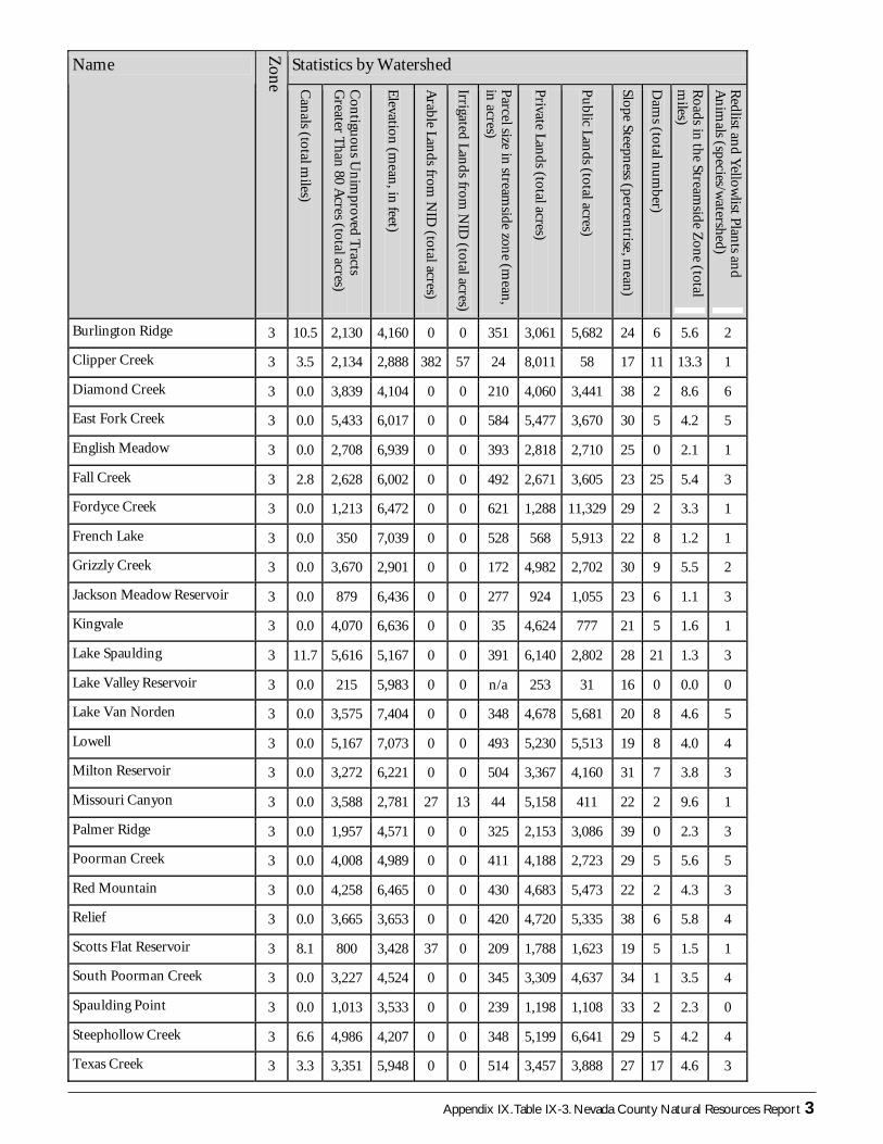
Appendix IX.Table IX-3. Nevada County Natural Resources Report 3
Burlington Ridge 3 10.5 2,130 4,160 0 0 351 3,061 5,682 24 6 5.6 2
Clipper Creek 3 3.5 2,134 2,888 382 57 24 8,011 58 17 11 13.3 1
Diamond Creek 3 0.0 3,839 4,104 0 0 210 4,060 3,441 38 2 8.6 6
East Fork Creek 3 0.0 5,433 6,017 0 0 584 5,477 3,670 30 5 4.2 5
English Meadow 3 0.0 2,708 6,939 0 0 393 2,818 2,710 25 0 2.1 1
Fall Creek 3 2.8 2,628 6,002 0 0 492 2,671 3,605 23 25 5.4 3
Fordyce Creek 3 0.0 1,213 6,472 0 0 621 1,288 11,329 29 2 3.3 1
French Lake 3 0.0 350 7,039 0 0 528 568 5,913 22 8 1.2 1
Grizzly Creek 3 0.0 3,670 2,901 0 0 172 4,982 2,702 30 9 5.5 2
Jackson Meadow Reservoir 3 0.0 879 6,436 0 0 277 924 1,055 23 6 1.1 3
Kingvale 3 0.0 4,070 6,636 0 0 35 4,624 777 21 5 1.6 1
Lake Spaulding 3 11.7 5,616 5,167 0 0 391 6,140 2,802 28 21 1.3 3
Lake Valley Reservoir 3 0.0 215 5,983 0 0 n/a 253 31 16 0 0.0 0
Lake Van Norden 3 0.0 3,575 7,404 0 0 348 4,678 5,681 20 8 4.6 5
Lowell 3 0.0 5,167 7,073 0 0 493 5,230 5,513 19 8 4.0 4
Milton Reservoir 3 0.0 3,272 6,221 0 0 504 3,367 4,160 31 7 3.8 3
Missouri Canyon 3 0.0 3,588 2,781 27 13 44 5,158 411 22 2 9.6 1
Palmer Ridge 3 0.0 1,957 4,571 0 0 325 2,153 3,086 39 0 2.3 3
Poorman Creek 3 0.0 4,008 4,989 0 0 411 4,188 2,723 29 5 5.6 5
Statistics by Watershed Name
Zon
e Can
als (total miles)
Con
tiguou
s Un
improved T
racts G
reater Than
80 Acres (total acres)
Elevation (m
ean, in feet)
Arable Lan
ds from N
ID (total acres)
Irrigated Lands from
NID
(total acres)
Parcel size in stream
side zone (m
ean,
in acres)
Private Lan
ds (total acres)
Pu
blic Lands (total acres)
Slope Steepness (percen
trise, mean)
Dam
s (total num
ber)
Roads in the Stream
side Zone (total
miles)
Redlist an
d Yellow
list Plants an
d A
nim
als (species/watershed)
Burlington Ridge 3 10.5 2,130 4,160 0 0 351 3,061 5,682 24 6 5.6 2
Clipper Creek 3 3.5 2,134 2,888 382 57 24 8,011 58 17 11 13.3 1
Diamond Creek 3 0.0 3,839 4,104 0 0 210 4,060 3,441 38 2 8.6 6
East Fork Creek 3 0.0 5,433 6,017 0 0 584 5,477 3,670 30 5 4.2 5
English Meadow 3 0.0 2,708 6,939 0 0 393 2,818 2,710 25 0 2.1 1
Fall Creek 3 2.8 2,628 6,002 0 0 492 2,671 3,605 23 25 5.4 3
Fordyce Creek 3 0.0 1,213 6,472 0 0 621 1,288 11,329 29 2 3.3 1
French Lake 3 0.0 350 7,039 0 0 528 568 5,913 22 8 1.2 1
Grizzly Creek 3 0.0 3,670 2,901 0 0 172 4,982 2,702 30 9 5.5 2
Jackson Meadow Reservoir 3 0.0 879 6,436 0 0 277 924 1,055 23 6 1.1 3
Kingvale 3 0.0 4,070 6,636 0 0 35 4,624 777 21 5 1.6 1
Lake Spaulding 3 11.7 5,616 5,167 0 0 391 6,140 2,802 28 21 1.3 3
Lake Valley Reservoir 3 0.0 215 5,983 0 0 n/a 253 31 16 0 0.0 0
Lake Van Norden 3 0.0 3,575 7,404 0 0 348 4,678 5,681 20 8 4.6 5
Lowell 3 0.0 5,167 7,073 0 0 493 5,230 5,513 19 8 4.0 4
Milton Reservoir 3 0.0 3,272 6,221 0 0 504 3,367 4,160 31 7 3.8 3
Missouri Canyon 3 0.0 3,588 2,781 27 13 44 5,158 411 22 2 9.6 1
Palmer Ridge 3 0.0 1,957 4,571 0 0 325 2,153 3,086 39 0 2.3 3
Poorman Creek 3 0.0 4,008 4,989 0 0 411 4,188 2,723 29 5 5.6 5
Red Mountain 3 0.0 4,258 6,465 0 0 430 4,683 5,473 22 2 4.3 3
Relief 3 0.0 3,665 3,653 0 0 420 4,720 5,335 38 6 5.8 4
Scotts Flat Reservoir 3 8.1 800 3,428 37 0 209 1,788 1,623 19 5 1.5 1
South Poorman Creek 3 0.0 3,227 4,524 0 0 345 3,309 4,637 34 1 3.5 4
Spaulding Point 3 0.0 1,013 3,533 0 0 239 1,198 1,108 33 2 2.3 0
Steephollow Creek 3 6.6 4,986 4,207 0 0 348 5,199 6,641 29 5 4.2 4
Texas Creek 3 3.3 3,351 5,948 0 0 514 3,457 3,888 27 17 4.6 3
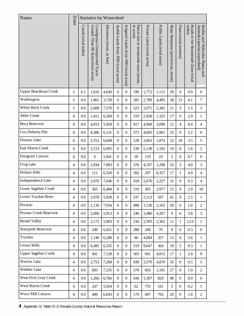
4 Appendix IX.Table IX-3. Nevada County Natural Resources Report
Statistics by Watershed Name
Zon
e Can
als (total miles)
Con
tiguou
s Un
improved T
racts G
reater Than
80 Acres (total acres)
Elevation (m
ean, in feet)
Arable Lan
ds from N
ID (total acres)
Irrigated Lands from
NID
(total acres)
Parcel size in stream
side zone (m
ean,
in acres)
Private Lan
ds (total acres)
Pu
blic Lands (total acres)
Slope Steepness (percen
trise, mean)
Dam
s (total num
ber)
Roads in the Stream
side Zone (total
miles)
Redlist an
d Yellow
list Plants an
d A
nim
als (species/watershed)
Upper Beardman Creek 3 6.1 1,616 4,640 0 0 190 1,772 1,115 29 0 0.9 0
Washington 3 0.0 1,861 3,728 0 0 285 2,789 4,495 38 15 4.1 7
White Rock Creek 3 0.0 2,608 7,570 0 0 523 3,071 5,382 21 3 1.5 3
Alder Creek 4 0.0 1,411 6,569 0 0 319 2,928 1,325 17 0 2.9 1
Boca Reservoir 4 0.0 4,915 5,959 0 0 417 4,949 3,098 12 4 8.4 4
Cox Delaney Flat 4 0.0 4,386 6,131 0 0 373 4,695 2,961 35 0 5.2 0
Donner Lake 4 0.0 2,552 6,648 0 0 128 3,603 1,874 22 26 3.5 5
East Martis Creek 4 0.0 3,723 6,005 0 0 239 5,138 1,192 10 6 1.6 2
Emigrant Canyon 4 0.0 0 5,941 0 0 59 119 18 3 0 0.7 0
Frog Lake 4 0.0 2,934 7,083 0 0 376 4,107 1,298 25 3 4.0 3
Hobart Hills 4 0.0 111 6,320 0 0 392 297 6,357 17 1 4.9 4
Independence Lake 4 0.0 2,076 7,646 0 0 418 2,076 2,227 31 0 0.3 4
Lower Sagehen Creek 4 0.0 365 6,484 0 0 319 365 2,977 15 0 2.9 10
Lower Truckee River 4 0.0 2,078 5,928 0 0 237 2,113 597 41 0 2.5 1
Perazzo 4 0.0 1,130 7,934 0 0 498 1,130 2,165 28 0 1.0 2
Prosser Creek Reservoir 4 0.0 2,006 5,913 0 0 240 3,486 4,207 9 6 3.8 3
Russel Valley 4 0.0 2,172 5,903 0 0 330 2,593 2,365 11 1 12.0 1
Stampede Reservoir 4 0.0 249 6,451 0 0 288 249 70 9 0 0.3 0
Truckee 4 0.0 1,140 6,288 0 0 46 4,084 357 13 6 5.6 1
Union Mills 4 0.0 6,485 6,335 0 0 319 9,647 364 18 5 9.3 1
Upper Sagehen Creek 4 0.0 941 7,128 0 0 503 941 4,813 17 1 2.4 9
Warren Lake 4 0.0 2,753 7,268 0 0 430 3,570 4,870 35 0 0.5 5
Webber Lake 4 0.0 693 7,535 0 0 576 693 1,191 27 0 1.0 2
West Fork Gray Creek 4 0.0 1,266 6,766 0 0 436 1,397 829 48 0 0.0 0
West Martis Creek 4 0.0 247 5,934 0 0 62 755 161 5 0 0.2 1
Worn Mill Canyon 4 0.0 489 6,043 0 0 170 497 792 20 0 1.8 2