Embed Size (px)
Citation preview

TABLE OF CONTENTS 7.0 THOROUGHFARE PLAN
Analysis of Future Conditions ………………………………..………………………… 7.2
Thoroughfare Plan ………………………………………………..………… 7.3
Proposed Cross-Sections …………….………………………………………….… 7.4 Arterials Minor Arterials Collectors Local Streets
Thoroughfare Plan Map (05-21-18) ……………………………………………………. Appendix

7.0 THOROUGHFARE PLAN
Town of Flower Mound Master Plan: Ordinance 18-18 7.2
Analysis of Future Conditions Future conditions of the Town of Flower Mound thoroughfare system were analyzed using 20-year land use assumptions supplied to us by the North Texas Council of Governments (NCTCOG). These land use projections for population, households, and employment were used in the NCTCOG computerized travel demand model to estimate future traffic volumes on the roadway system within and adjacent to Flower Mound. In addition, existing traffic counts were collected by the Town of Flower Mound and used by Kimley-Horn to validate the results of the NCTCOG travel model. The land use plan for the western region of Town was updated in 2008. Future thoroughfares in that region are addressed in this plan based on the Area Plan. The Town’s adoption of the land use plan incorporates the Town’s “SMARTGrowth” initiative. This plan is not part of the NCTCOG’s 2020 travel model. It is important to note that some manual adjustments had to be made to the traffic assignment to adjust for the Town’s land use plan, based on traditional transportation distribution and assignment techniques. An analysis of the results of the travel demand modeling effort yielded several findings and implications: 1. The roadways projected to carry the most traffic within Flower Mound are FM 1171, FM 3040, Morriss
Road, FM 2499, Gerault Road, and US 377. Defined as Major Arterials, except Morriss Road, these roadways should be planned to carry significant traffic in the year 2020, and efforts to coordinate with TxDOT to obtain funding and construct improvements continue.
2. The major roadways that connect to the TxDOT regional freeway system likely will be congested at
interchanges and major intersections. These roadways are FM 1171, FM 3040, FM 407, FM 2499 and US 377. Alternate routes to connect with the freeway system are needed, and this effort will involve coordination with adjoining cities. The primary candidates for these alternative routes are Lakeside Parkway to SH 121 in Grapevine, an extension of Spinks Road to Valley Parkway in Lewisville, and an extension of Kirkpatrick Lane to Bellaire Boulevard in Lewisville.
3. The thoroughfare alignment of the Flower Mound Road extension west of Bruton-Orand is a four-lane
urban minor arterial all the way to FM 1171. Due to the nature of this facility, a six-lane major arterial is not recommended.
4. In general, the Flower Mound roadways classified as collectors do not carry volumes that warrant four
lanes. It appears that high-quality two-lane roads with provisions for turning traffic and shoulders are a viable alternative.
5. The volumes projected on Bruton-Orand do not indicate need for a six-lane arterial. A minor arterial,
which would connect adjacent land uses and the major roadways, appears appropriate for Bruton-Orand.
6. The projected volume of Morriss Road is expected to be over 25,000 vehicles per day. Gerault Road
has been improved to a six-lane section to provide a direct connection from Morriss Road to SH 121. 7. Generally, the system of planned arterials appears capable of handling the traffic demand within
Flower Mound. The arterial system should be planned and depended on to carry traffic to, through, and from the Town of Flower Mound. The collector system should be configured to provide access to, not through, adjacent land uses. This suggests that collectors generally should not be continuous for long distances and should not encourage through-traffic in residential neighborhoods. To discourage traffic through neighborhoods, it is essential that adequate capacity and acceptable operating conditions be maintained on the major roadway system.

7.0 THOROUGHFARE PLAN
Town of Flower Mound Master Plan: Ordinance 18-18 7.3
Thoroughfare Plan The recommended thoroughfare plan for Flower Mound is based on information obtained at public hearings and the analysis of existing and projected conditions. The major features of this plan are as follows: 1. Lakeside Parkway Connection to SH 121 - A direct connection to SH 121 provides another access
to the center of Flower Mound and relieves FM 2499. 2. Flower Mound Road - Flower Mound Road has been improved and connects with FM 1171 as a
four-lane Minor Arterial roadway with median, curb, and gutter. 3. Kirkpatrick Extension - The alignment of this roadway should be extended to provide a connection to
Bellaire Boulevard in Lewisville. 4. Collector Street Cross Sections - Two cross-sections have been developed to reflect the Town’s
characteristics and collector street needs. Urban collectors have a 36-foot wide pavement with curb and gutter. Rural collectors have two 12-foot travel lanes but no curb or gutter; however, full-width shoulders could provide for bicycle travel and left-turn bypass lanes.

7.0 THOROUGHFARE PLAN
Town of Flower Mound Master Plan: Ordinance 18-18 7.4
Proposed Cross-Sections Cross-sections describe the basic attributes of roadways: lanes, sidewalks, drainage and pavement, medians, parkway, and right-of-way (ROW). All dimensions other than lane widths presented in the accompanying cross-sections are minimums. Based on the travel needs and community goals for appearance and character, several typical roadway cross-sections have been developed to specify the basic ROW dedication needs and design criteria. Note that all urban sections shall have a minimum offset of four feet from the back of curb to the sidewalk and a one foot minimum from the ROW line to the back of the sidewalk. Two basic categories, arterials and collectors, contain several variations to meet differing travel needs. Arterials Two different arterial classes were identified for use in Flower Mound: Major Arterials and Minor Arterials. Major Arterial Major Arterials carry traffic long distances and connect the Town to the regional freeway system and other major regional activity centers. These facility types serve Flower Mound traffic and traffic traveling through Flower Mound. They are the most heavily traveled roadways and require some degree of access control. Access standards for Major Arterials, which are more stringent than those applied to Minor Arterials, should address driveways, median-openings, and deceleration lanes. Major (Principal) Arterial The proposed Major Arterial cross-section shown below consists of a six-lane roadway with 12' lanes, an 18' median, curbs, gutters, and sidewalks within 120' of ROW.

7.0 THOROUGHFARE PLAN
Town of Flower Mound Master Plan: Ordinance 18-18 7.5
Greenway Urban Arterial The next Major Arterial is called a Greenway Urban Arterial. It is designed to provide for a large (42') landscaped median and 120' of ROW. This typical section allows the Town the flexibility to widen to six lanes, if needed, without taking additional ROW. 4-lane divided with extra-wide greenway median and 120’ right-of-way. Greenway Rural Arterial The third and final Major Arterial is called a Greenway Rural Arterial. For this typical section, the raised curb and gutter median is replaced with a grassy swale in the median that drains into an underground system. Two 11' travel lanes are provided in each direction. The minimum ROW is 120'. This facility type reflects the desire to maintain a rural character in the western portion of the Town.

7.0 THOROUGHFARE PLAN
Town of Flower Mound Master Plan: Ordinance 20-12 7.6
Minor Arterial Two different cross-sections for Minor Arterials were developed to maintain the rural character of the western portion of Flower Mound. These facility types serve traffic originating in or destined for locations within Flower Mound, and they are not intended to serve traffic traveling through the Town. Urban and rural cross-sections, which can be distinguished by their differing approaches to roadway drainage, are recommended. Also, a suburban typical has been developed for those facilities that want a rural feel; it features shoulders, open swale ditches, and a raised, landscaped median with curb and gutter. Urban Minor Arterial An Urban Minor Arterial, as shown below, has two 12' travel lanes in each direction separated by a 16' median. The minimum ROW is 90'. 4-lane divided with 90’ of right-of-way Urban Minor Arterial Undivided 4-lanes with 70’ right-of-way Urban Minor Arterial with On-Street Parking Street, arterial (minor with on-street parking), means an urban minor arterial with on-street parking. Minor arterial streets are designed to serve traffic originating in or destined for locations within town and are intended to be used in Mixed Use type environments. It will have 10’ lanes with a 16 foot median and 18 foot angled parking on the outside curb. Curbs would extend to limit parking near intersections to provide better operations and visibility at these locations and reduce pedestrian crossing distance to approximately 56 feet. These sections of roadway will typically have large sidewalks to accommodate pedestrians.

7.0 THOROUGHFARE PLAN
Town of Flower Mound Master Plan: Ordinance 20-12 7.7

7.0 THOROUGHFARE PLAN
Town of Flower Mound Master Plan: Ordinance 20-12 7.8
Urban Minor with Bike Lane
Urban Minor Arterials with Bike Lane serve traffic originating in or destined for locations within Flower Mound and are not intended to serve traffic traveling through the Town. Roadway drainage is provided with curb and gutter. The outside 5’ of pavement is to be designated as a 5’ marked bike lane for bicycle traffic.
7.0 THOROUGHFARE PLAN
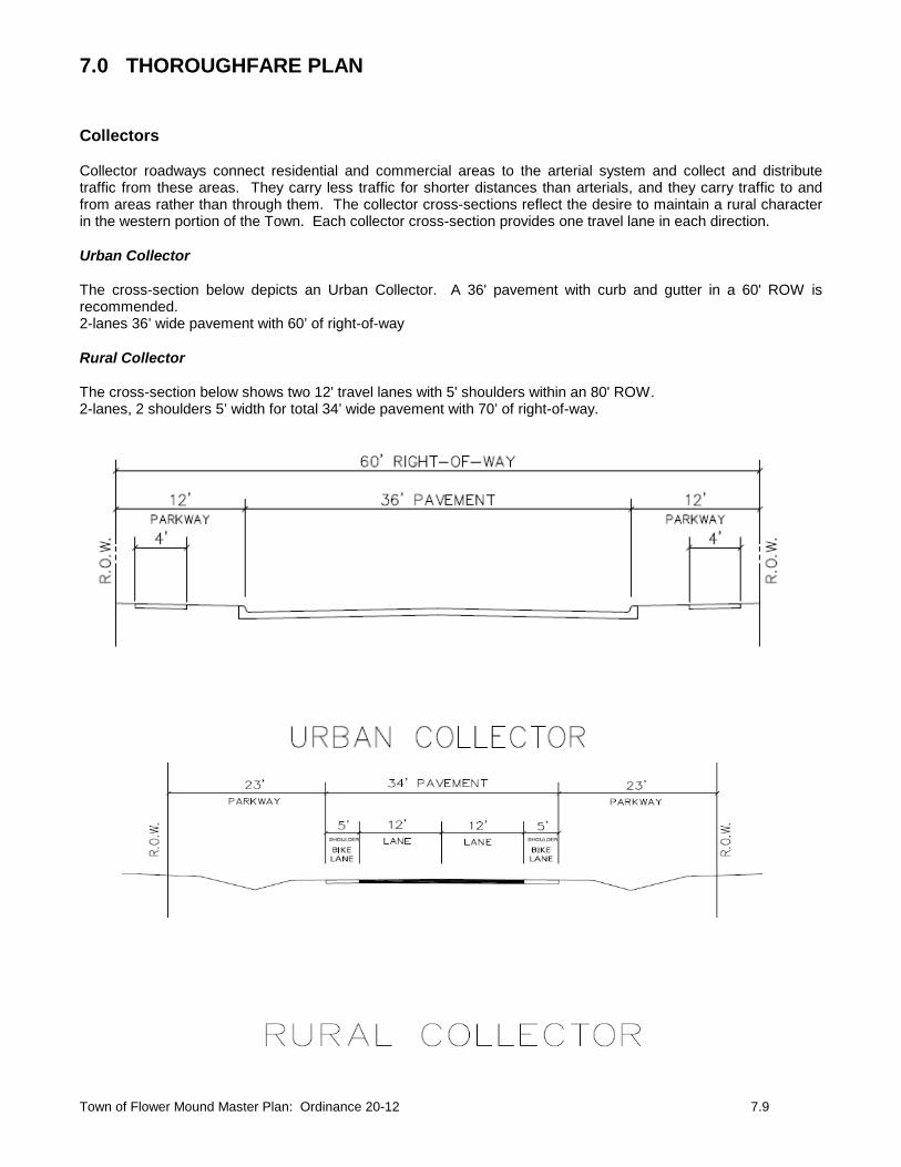
Town of Flower Mound Master Plan: Ordinance 20-12 7.9
Collectors Collector roadways connect residential and commercial areas to the arterial system and collect and distribute traffic from these areas. They carry less traffic for shorter distances than arterials, and they carry traffic to and from areas rather than through them. The collector cross-sections reflect the desire to maintain a rural character in the western portion of the Town. Each collector cross-section provides one travel lane in each direction. Urban Collector The cross-section below depicts an Urban Collector. A 36' pavement with curb and gutter in a 60' ROW is recommended. 2-lanes 36’ wide pavement with 60’ of right-of-way Rural Collector The cross-section below shows two 12' travel lanes with 5' shoulders within an 80' ROW. 2-lanes, 2 shoulders 5’ width for total 34’ wide pavement with 70’ of right-of-way.

7.0 THOROUGHFARE PLAN
Town of Flower Mound Master Plan: Ordinance 20-12 7.10
Local Streets The following are four variations of the Local Street facility type. Local Residential Urban The Local Residential Urban cross-section features 15' travel lanes with curb and gutter all within a 50' ROW. Local Residential Estate The Local Residential Estate cross-section features two 12' lanes within a 24' ROW.

7.0 THOROUGHFARE PLAN
Town of Flower Mound Master Plan: Ordinance 20-12 7.11
Local Commercial The next local street section depicts a Local Commercial street. A 36' pavement section with curb and gutter in 60' of ROW is recommended. Local Cluster Development Below is a Local Cluster Development Street. This section depicts 24' of pavement and one-foot drop curbs.

!(
!@
!@
!@
!.
!.
!.
!.
!.
!.
!.
!. Roundabout!@ Grade Separation!( Diamond Interchange
Major ArterialGreenway Urban ArterialGreenway Rural ArterialUrban Minor Arterial w/Bike LaneUrban Minor Arterial w/On-Street ParkingUrban Minor ArterialUrban Minor Arterial UndividedUrban CollectorRural CollectorService Road
Functional Street Classifications
May 21, 2018
THOROUGHFARE PLANTOWN OF FLOWER MOUND
.0 4,000 8,0002,000
Scale in Feet
Denton CountyTarrant County
Denton CountyDallas County
FM 1171
US H
WY 37
7
QUAIL RUN
SHILO
H RD
KINGS RD LUSK
LN
PETERS COLONY RD
W WINDSOR DR
WAKETON RD
RIPP
Y RD
MCKAMY CREEK RD
OLD
SETT
LERS
RD
FM 3040
EATON DR
KIRKP
ATRI
CK LN
GARD
EN R
IDGE
BLVD
FM 2499
SPINKS RD
FM 24
99
COLLEGE PKWY
DIXON LN
FM 407
CHIN
N CH
APEL
RD
BROW
NING
DR
STON
E HILL
KIRKPATRICK LN
KIRKPATRICK LN
FM 1171
RED
ROCK
LN
SCEN
IC D
R
WICHITA TRL
SKILL
ERN
RD
FM 1171
SIMMO
NS R
D
DUNC
AN LN
LONG
PRAIR
IE RD
ABERDEEN DR
RIDG
ECRE
ST D
R
SHILO
H RD
MORR
ISS R
D
FARM
S PKW
Y
KINGS RD
WAKETON RD
FLOWER MOUND RD
BRUTONOR
AND
BLVD
AUBU
RNDR
BRID
LEWO
ODB
LVD
CHUR
CHILL
DR
VALLEY RIDGE BLV D
TIMBE
R CREE
K RD
CROSS TIMBERS RD
SAGEBRUSH DR
FIREWHE EL DR
FOREST VISTA DR
LAKE
FORE
STBL
VD
LEXIN
GTON
AVE
ST RAITLN
GERAU
LTRD
IH-35
W
LAKESIDE PKWY
SILVE
RON BLV D