Embed Size (px)
Citation preview

Sandia is a multiprogram laboratory operated by Sandia Corporation, a Lockheed Martin Company,for the United States Department of Energy under contract DE-AC04-94AL85000.
Taking Reconnaissance to Taking Reconnaissance to Another LevelAnother Level
Margaret MurraySandia National Laboratories
Albuquerque, NM505-844-7432
UAVs: The Way AheadWashington, DC
October 2004
2UAV’s: The Way Ahead
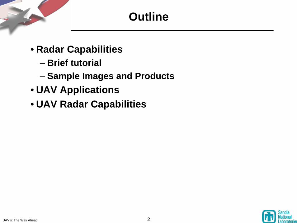
Outline
• Radar Capabilities– Brief tutorial– Sample Images and Products
• UAV Applications• UAV Radar Capabilities
3UAV’s: The Way Ahead
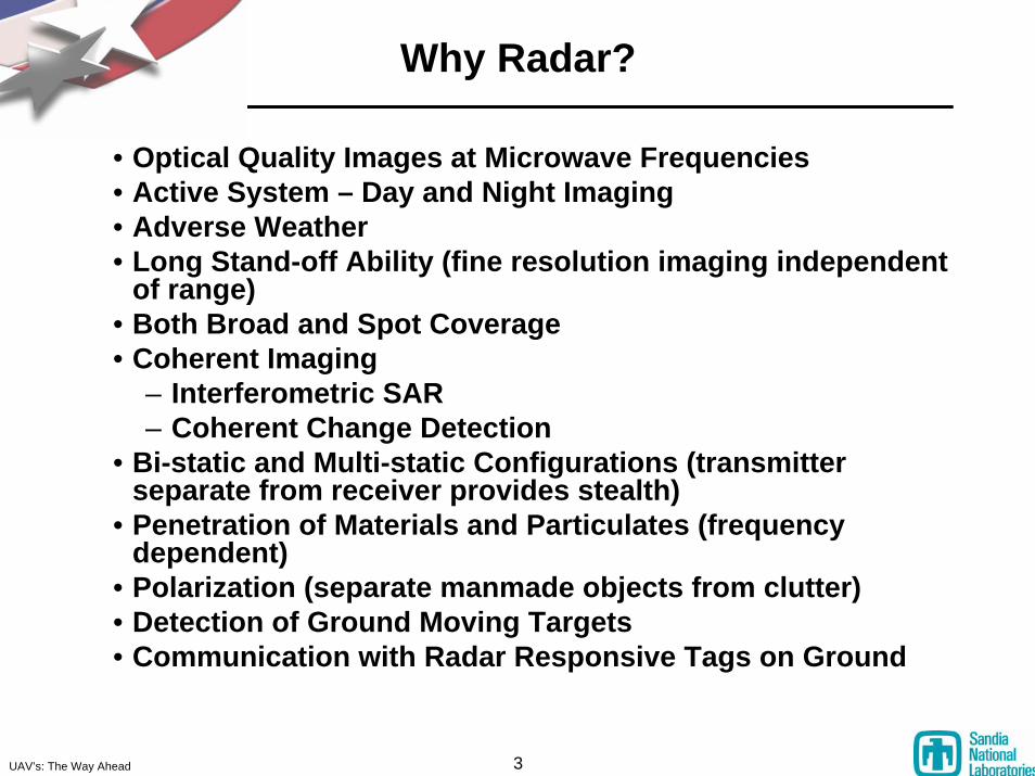
Why Radar?
• Optical Quality Images at Microwave Frequencies• Active System – Day and Night Imaging• Adverse Weather• Long Stand-off Ability (fine resolution imaging independent
of range)• Both Broad and Spot Coverage• Coherent Imaging
– Interferometric SAR– Coherent Change Detection
• Bi-static and Multi-static Configurations (transmitter separate from receiver provides stealth)
• Penetration of Materials and Particulates (frequency dependent)
• Polarization (separate manmade objects from clutter)• Detection of Ground Moving Targets• Communication with Radar Responsive Tags on Ground
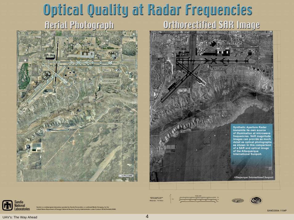
4UAV’s: The Way Ahead
5UAV’s: The Way Ahead
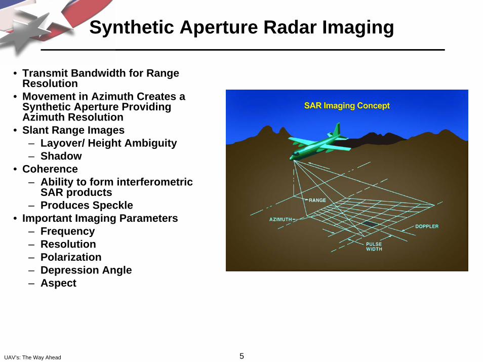
Synthetic Aperture Radar Imaging
• Transmit Bandwidth for Range Resolution
• Movement in Azimuth Creates a Synthetic Aperture Providing Azimuth Resolution
• Slant Range Images– Layover/ Height Ambiguity– Shadow
• Coherence– Ability to form interferometric
SAR products– Produces Speckle
• Important Imaging Parameters– Frequency– Resolution– Polarization – Depression Angle– Aspect
6UAV’s: The Way Ahead
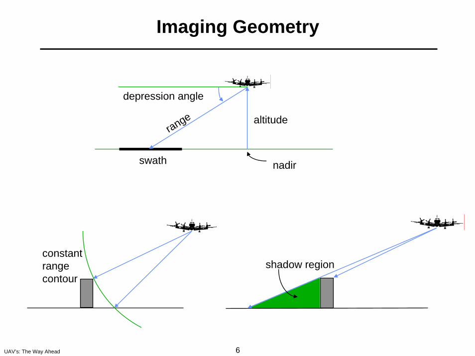
Imaging Geometry
altitude
nadir
range
swath
depression angle
shadow regionconstantrangecontour
7UAV’s: The Way Ahead
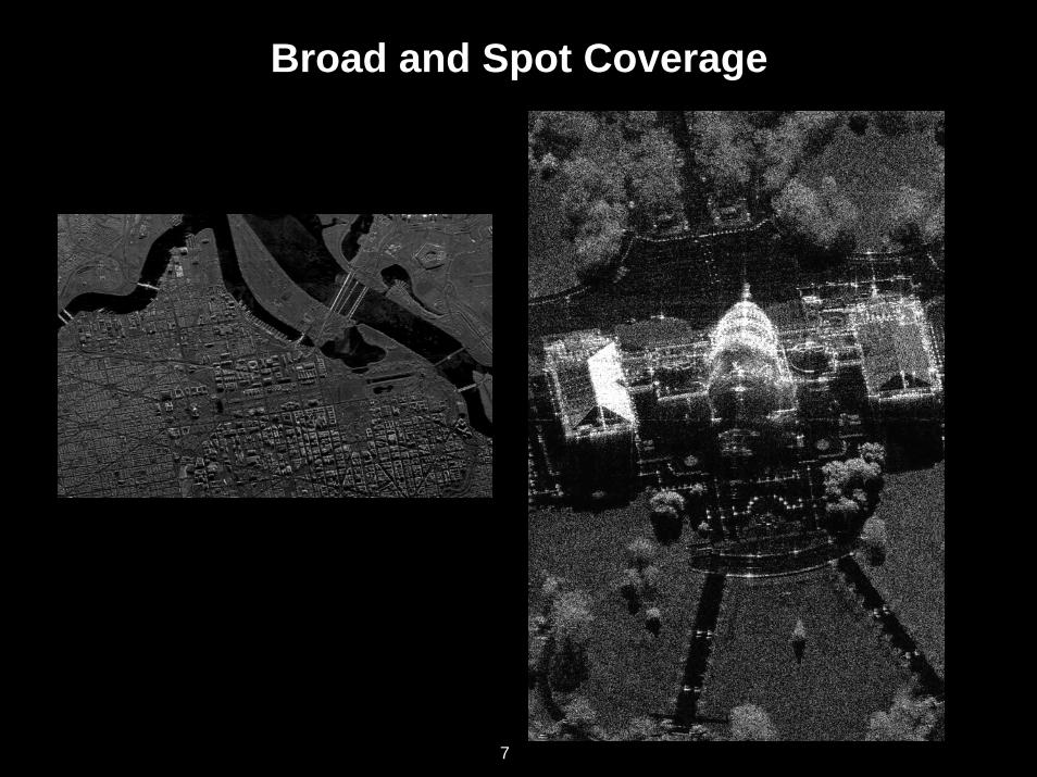
Broad and Spot Coverage
7
8UAV’s: The Way Ahead
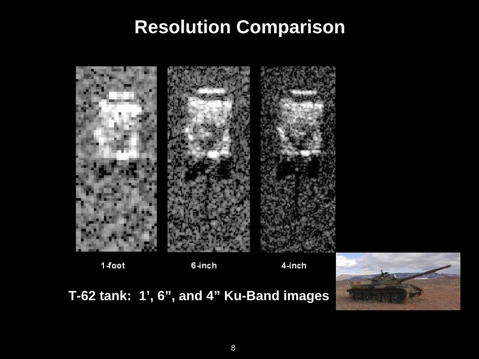
Resolution Comparison
T-62 tank: 1’, 6”, and 4” Ku-Band images
8

9UAV’s: The Way Ahead
Frequency Comparison – Ku vs. UHF
6-inch resolutionKu-bandVV polarization
.5 meter resolutionUHF band (570MHz)VV polarization
9
10UAV’s: The Way Ahead
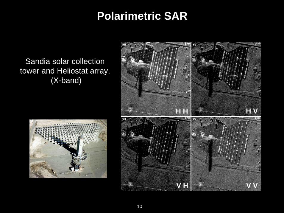
Polarimetric SAR
H H H V
V H V V
Sandia solar collection tower and Heliostat array.
(X-band)
10
11UAV’s: The Way Ahead
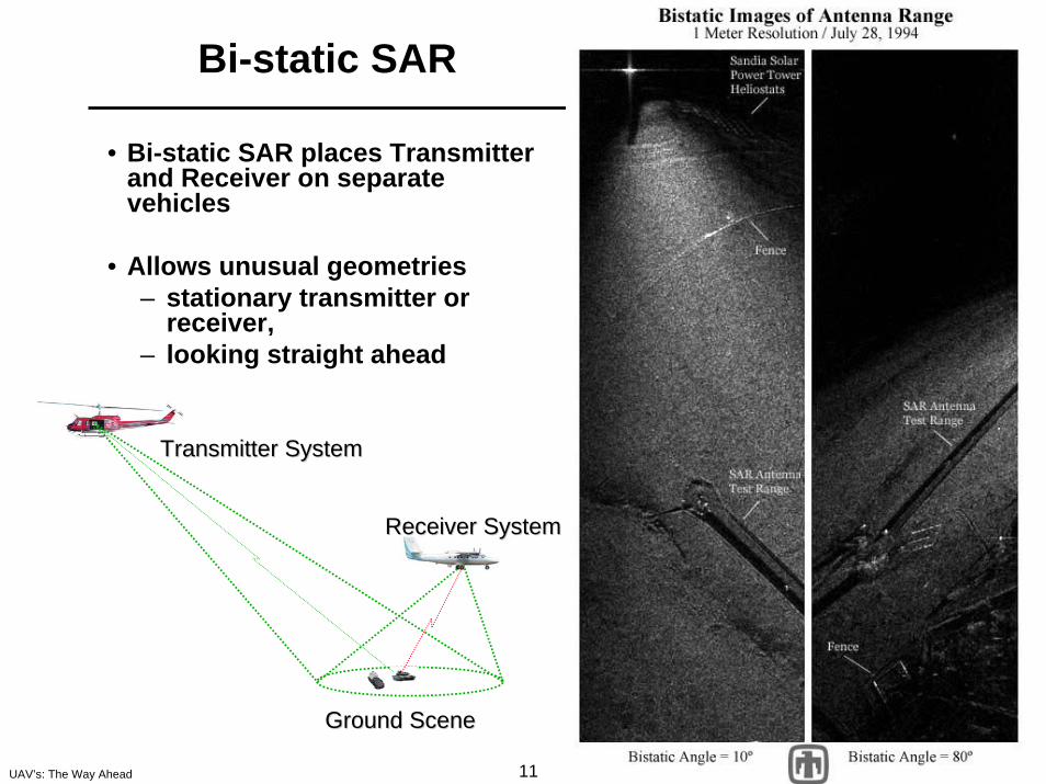
• Bi-static SAR places Transmitter and Receiver on separate vehicles
• Allows unusual geometries– stationary transmitter or
receiver, – looking straight ahead
Bi-static SAR
Transmitter SystemTransmitter System
Receiver SystemReceiver System
Ground SceneGround Scene
12UAV’s: The Way Ahead
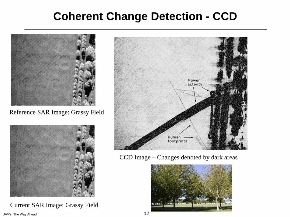
Coherent Change Detection - CCD
Reference SAR Image: Grassy Field
CCD Image – Changes denoted by dark areas
Current SAR Image: Grassy Field
13UAV’s: The Way Ahead
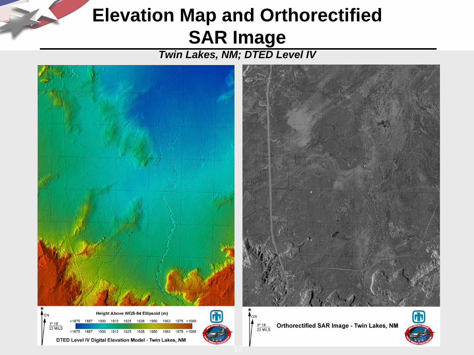
Elevation Map and Orthorectified SAR Image
Twin Lakes, NM; DTED Level IV
13
14UAV’s: The Way Ahead
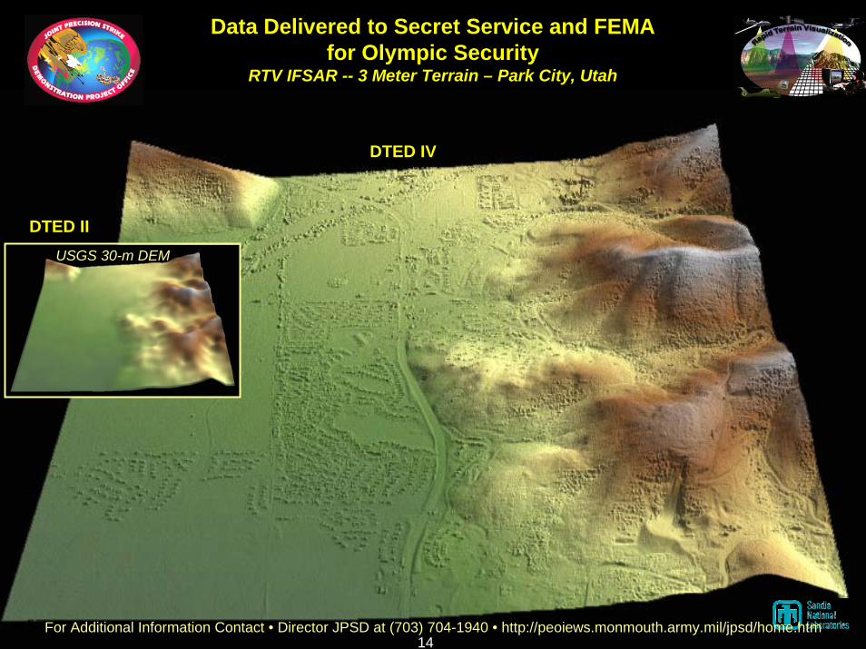
Data Delivered to Secret Service and FEMAfor Olympic Security
RTV IFSAR -- 3 Meter Terrain – Park City, Utah
USGS 30-m DEM
DTED II
DTED IV
For Additional Information Contact • Director JPSD at (703) 704-1940 • http://peoiews.monmouth.army.mil/jpsd/home.htm14
15UAV’s: The Way Ahead
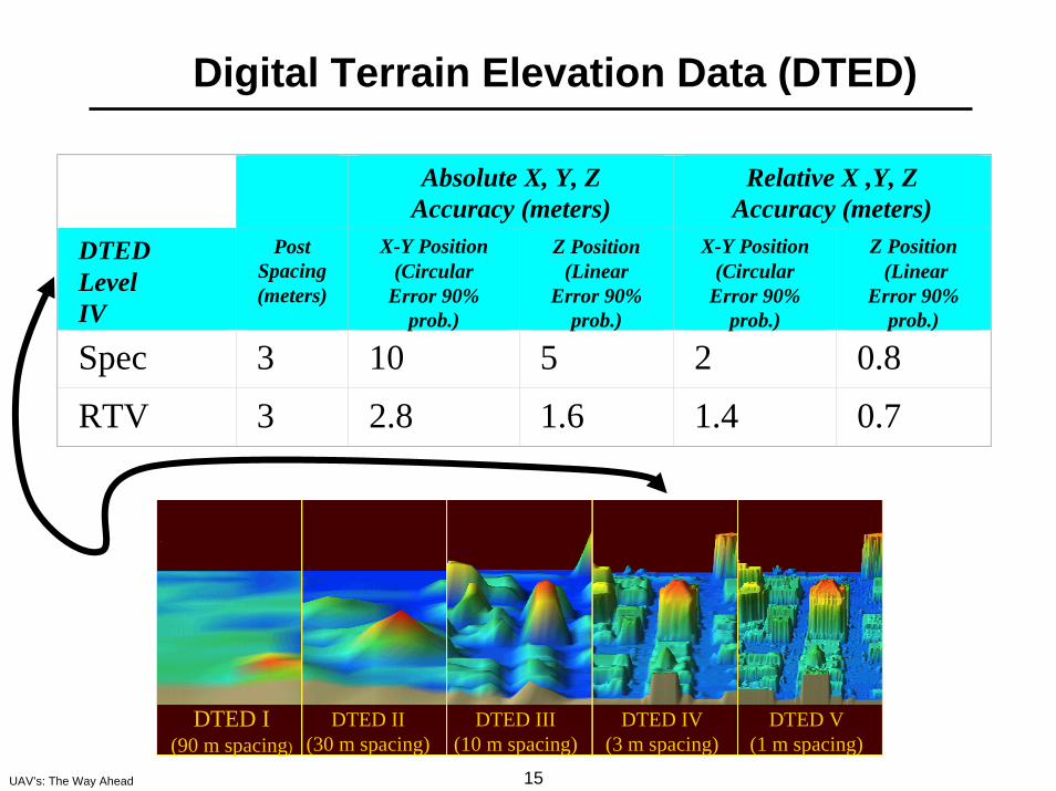
Digital Terrain Elevation Data (DTED)
DTED I(90 m spacing)
DTED II(30 m spacing)
DTED III(10 m spacing)
DTED IV(3 m spacing)
DTED V(1 m spacing)
Absolute X, Y, Z Accuracy (meters)
Relative X ,Y, Z Accuracy (meters)
DTED LevelIV
Post Spacing(meters)
X-Y Position(Circular
Error 90% prob.)
Z Position (Linear
Error 90% prob.)
X-Y Position(Circular
Error 90% prob.)
Z Position(Linear
Error 90% prob.)
Spec 3 10 5 2 0.8
RTV 3 2.8 1.6 1.4 0.7
16UAV’s: The Way Ahead
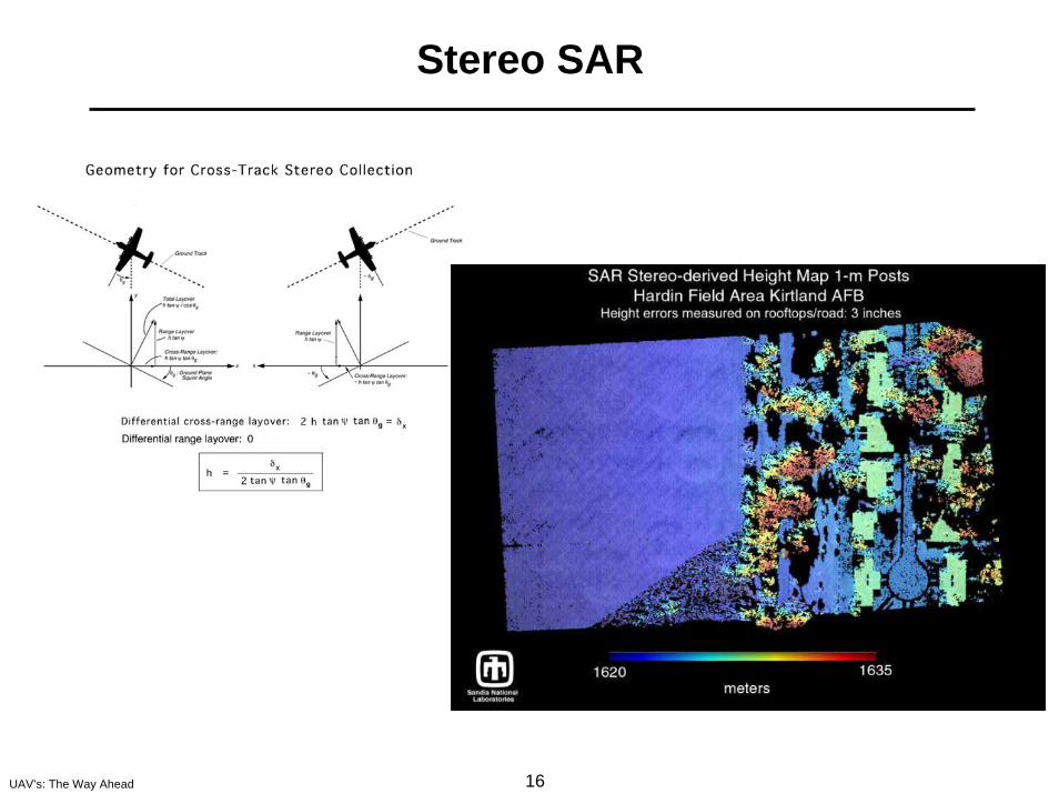
Stereo SAR
17UAV’s: The Way Ahead
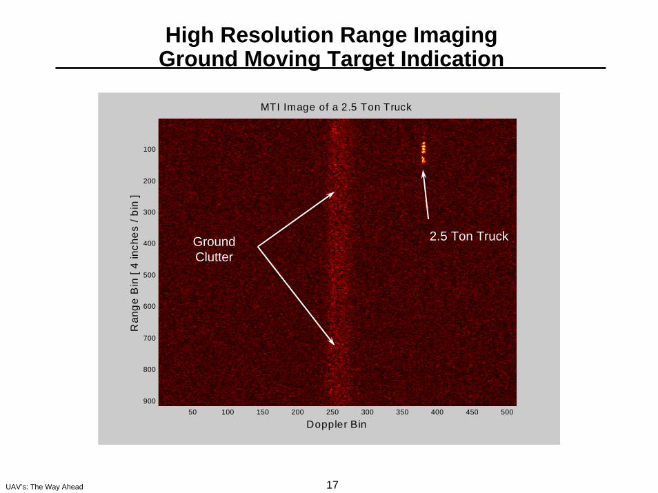
High Resolution Range ImagingGround Moving Target Indication
Doppler Bin
Ran
ge B
in [
4 in
ches
/ bi
n ]
MTI Image of a 2.5 Ton Truck
50 100 150 200 250 300 350 400 450 500
100
200
300
400
500
600
700
800
900
2.5 Ton TruckGroundClutter
18UAV’s: The Way Ahead
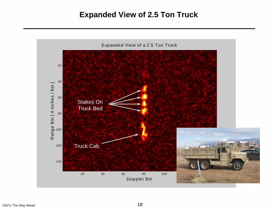
Expanded View of 2.5 Ton Truck
Doppler Bin
Ran
ge B
in [
4 in
ches
/ bi
n ]
Expanded View of a 2.5 Ton Truck
20 40 60 80 100 120 140
20
40
60
80
100
120
140
Stakes OnTruck Bed
Truck Cab
19UAV’s: The Way Ahead
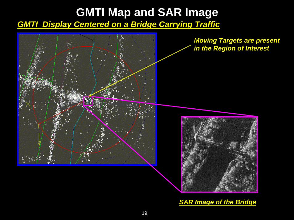
GMTI Map and SAR ImageGMTI Display Centered on a Bridge Carrying Traffic
Moving Targets are presentin the Region of Interest
SAR Image of the Bridge19
20UAV’s: The Way Ahead
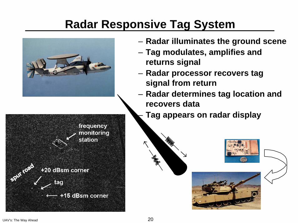
– Radar illuminates the ground scene– Tag modulates, amplifies and
returns signal– Radar processor recovers tag
signal from return– Radar determines tag location and
recovers data– Tag appears on radar display
Radar Responsive Tag System
←
←
21UAV’s: The Way Ahead
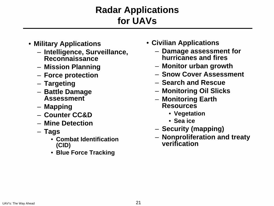
Radar Applicationsfor UAVs
• Civilian Applications– Damage assessment for
hurricanes and fires– Monitor urban growth– Snow Cover Assessment– Search and Rescue– Monitoring Oil Slicks– Monitoring Earth
Resources• Vegetation• Sea ice
– Security (mapping)– Nonproliferation and treaty
verification
• Military Applications– Intelligence, Surveillance,
Reconnaissance– Mission Planning– Force protection– Targeting– Battle Damage
Assessment– Mapping– Counter CC&D– Mine Detection– Tags
• Combat Identification (CID)
• Blue Force Tracking
22UAV’s: The Way Ahead
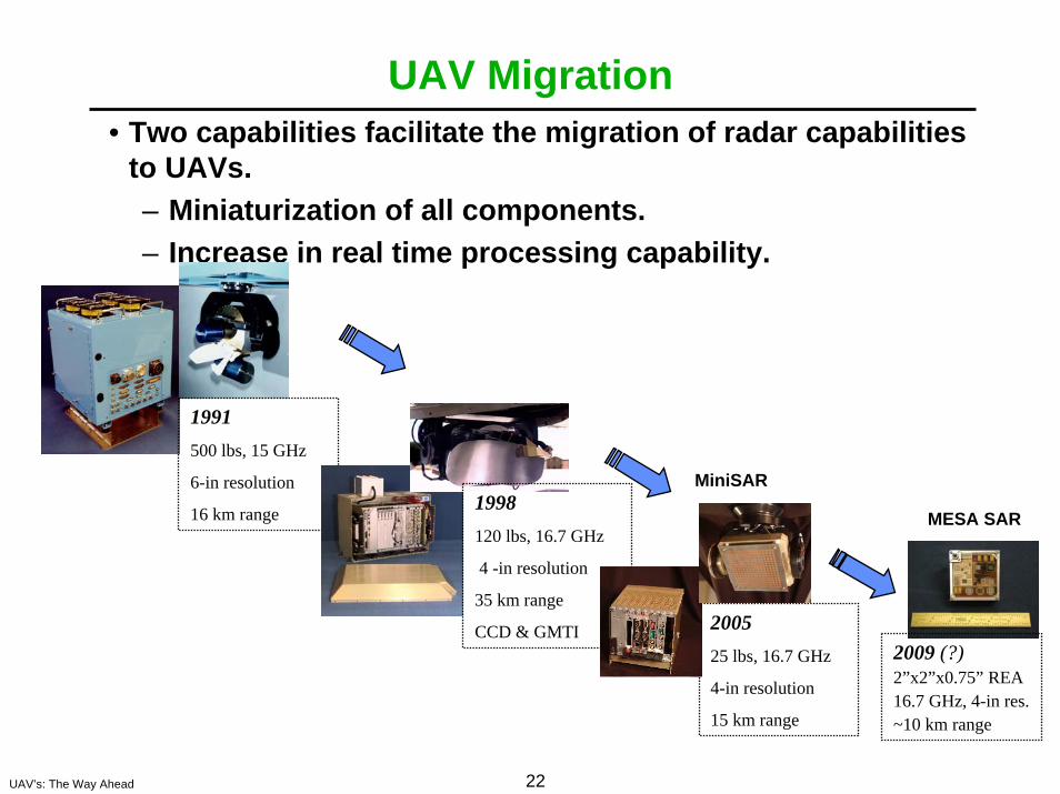
UAV Migration• Two capabilities facilitate the migration of radar capabilities
to UAVs.– Miniaturization of all components.– Increase in real time processing capability.
1991500 lbs, 15 GHz
6-in resolution
16 km range 1998120 lbs, 16.7 GHz
4 -in resolution
35 km range
CCD & GMTI 200525 lbs, 16.7 GHz
4-in resolution
15 km range
2009 (?)2”x2”x0.75” REA16.7 GHz, 4-in res.~10 km range
MiniSAR
MESA SAR
23UAV’s: The Way Ahead
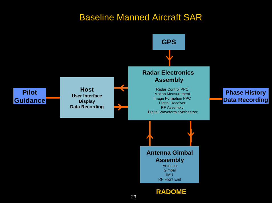
Baseline Manned Aircraft SAR
GPS
PilotGuidance
HostUser Interface
DisplayData Recording
Phase HistoryData Recording
Antenna GimbalAssembly
AntennaGimbal
IMURF Front End
Radar Electronics AssemblyRadar Control PPC
Motion MeasurementImage Formation PPC
Digital ReceiverRF Assembly
Digital Waveform Synthesizer
RADOME23
24UAV’s: The Way Ahead
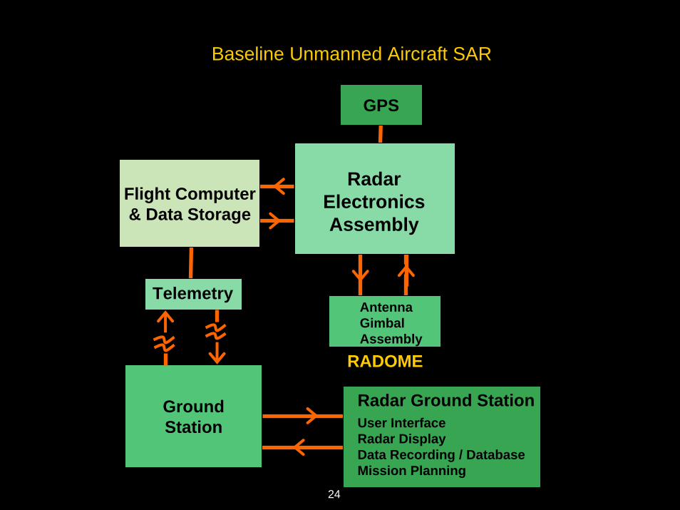
Baseline Unmanned Aircraft SAR
GroundStation
GPS
RadarElectronicsAssembly
Flight Computer& Data Storage
Telemetry
Radar Ground StationUser InterfaceRadar DisplayData Recording / DatabaseMission Planning
AntennaGimbalAssembly
RADOME
24
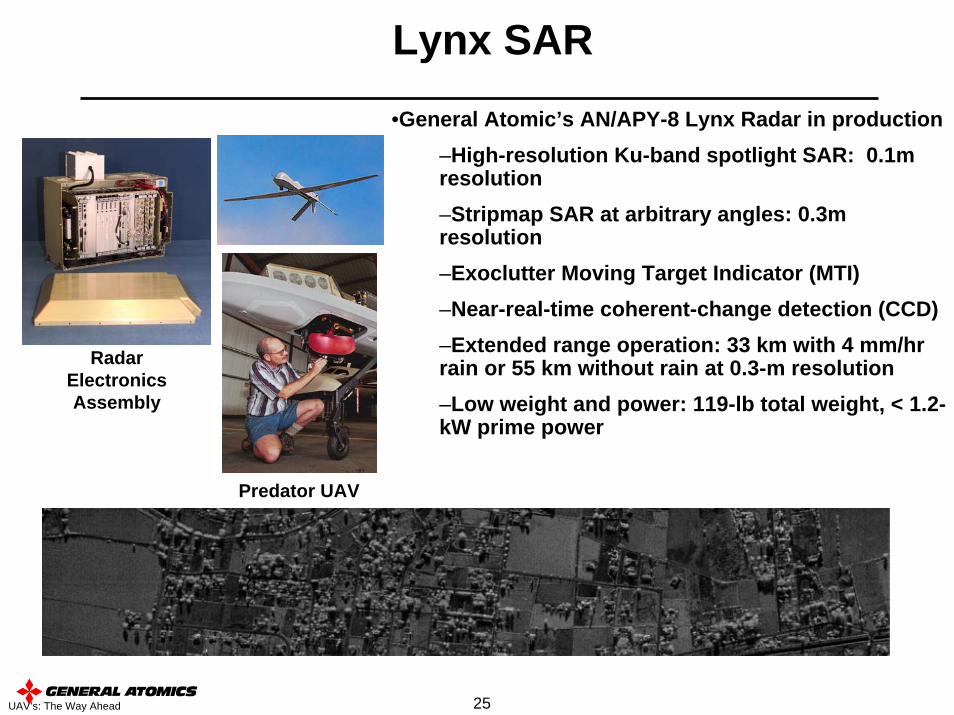
25UAV’s: The Way Ahead
Lynx SAR
Predator UAV
Radar Electronics Assembly
•General Atomic’s AN/APY-8 Lynx Radar in production–High-resolution Ku-band spotlight SAR: 0.1m resolution–Stripmap SAR at arbitrary angles: 0.3m resolution–Exoclutter Moving Target Indicator (MTI)–Near-real-time coherent-change detection (CCD)–Extended range operation: 33 km with 4 mm/hr rain or 55 km without rain at 0.3-m resolution–Low weight and power: 119-lb total weight, < 1.2-kW prime power
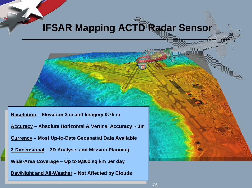
26UAV’s: The Way Ahead
IFSAR Mapping ACTD Radar Sensor
Resolution – Elevation 3 m and Imagery 0.75 m
Accuracy – Absolute Horizontal & Vertical Accuracy ~ 3m
Currency – Most Up-to-Date Geospatial Data Available
3-Dimensional – 3D Analysis and Mission Planning
Wide-Area Coverage – Up to 9,800 sq km per day
Day/Night and All-Weather – Not Affected by Clouds
26
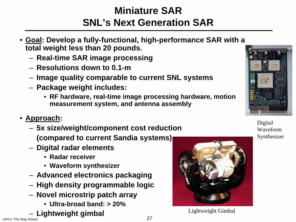
27UAV’s: The Way Ahead
Miniature SARSNL’s Next Generation SAR
• Goal: Develop a fully-functional, high-performance SAR with a total weight less than 20 pounds.– Real-time SAR image processing– Resolutions down to 0.1-m– Image quality comparable to current SNL systems– Package weight includes:
• RF hardware, real-time image processing hardware, motion measurement system, and antenna assembly
• Approach: – 5x size/weight/component cost reduction
(compared to current Sandia systems)– Digital radar elements
• Radar receiver • Waveform synthesizer
– Advanced electronics packaging – High density programmable logic– Novel microstrip patch array
• Ultra-broad band: > 20%– Lightweight gimbal Lightweight Gimbal
Digital Waveform Synthesizer
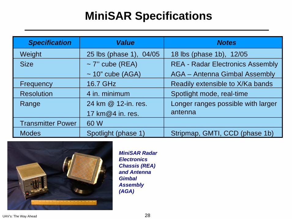
28UAV’s: The Way Ahead
MiniSAR Specifications
Specification Value NotesWeight 25 lbs (phase 1), 04/05 18 lbs (phase 1b), 12/05Size ~ 7’’ cube (REA)
~ 10” cube (AGA)REA - Radar Electronics Assembly AGA – Antenna Gimbal Assembly
Frequency 16.7 GHz Readily extensible to X/Ka bandsResolution 4 in. minimum Spotlight mode, real-timeRange 24 km @ 12-in. res.
17 km@4 in. res.Longer ranges possible with larger antenna
Transmitter Power 60 WModes Spotlight (phase 1) Stripmap, GMTI, CCD (phase 1b)
MiniSAR Radar Electronics Chassis (REA) and Antenna Gimbal Assembly (AGA)
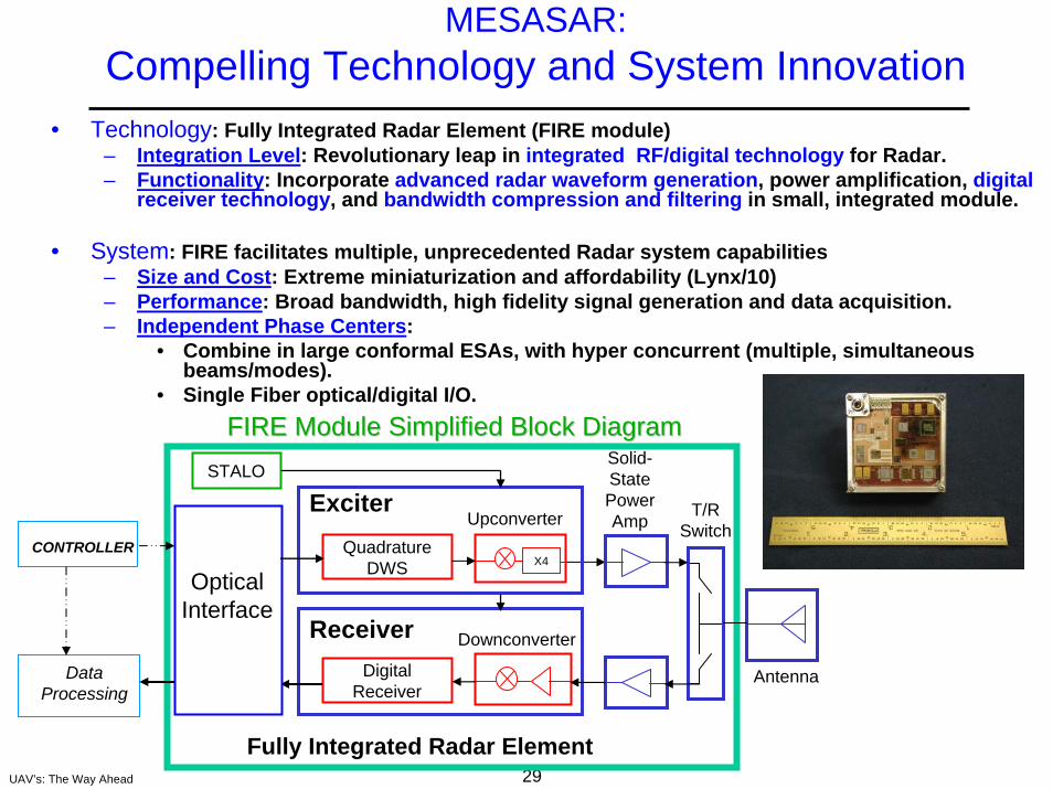
MESASAR: Compelling Technology and System Innovation
29UAV’s: The Way Ahead
• Technology: Fully Integrated Radar Element (FIRE module)– Integration Level: Revolutionary leap in integrated RF/digital technology for Radar.– Functionality: Incorporate advanced radar waveform generation, power amplification, digital
receiver technology, and bandwidth compression and filtering in small, integrated module.
• System: FIRE facilitates multiple, unprecedented Radar system capabilities– Size and Cost: Extreme miniaturization and affordability (Lynx/10)– Performance: Broad bandwidth, high fidelity signal generation and data acquisition.– Independent Phase Centers:
• Combine in large conformal ESAs, with hyper concurrent (multiple, simultaneous beams/modes).
• Single Fiber optical/digital I/O.FIRE Module Simplified Block DiagramFIRE Module Simplified Block Diagram
Solid-State Power Amp
DownconverterReceiverDigital
Receiver
X4
ExciterQuadrature
DWS
Upconverter T/R Switch
DataProcessing
Antenna
CONTROLLER
Optical Interface
STALO
Fully Integrated Radar Element
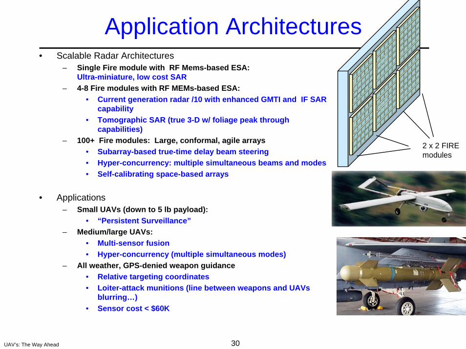
30UAV’s: The Way Ahead
Application Architectures• Scalable Radar Architectures
– Single Fire module with RF Mems-based ESA: Ultra-miniature, low cost SAR
– 4-8 Fire modules with RF MEMs-based ESA: • Current generation radar /10 with enhanced GMTI and IF SAR
capability• Tomographic SAR (true 3-D w/ foliage peak through
capabilities)– 100+ Fire modules: Large, conformal, agile arrays
• Subarray-based true-time delay beam steering• Hyper-concurrency: multiple simultaneous beams and modes• Self-calibrating space-based arrays
• Applications– Small UAVs (down to 5 lb payload):
• “Persistent Surveillance”– Medium/large UAVs:
• Multi-sensor fusion• Hyper-concurrency (multiple simultaneous modes)
– All weather, GPS-denied weapon guidance• Relative targeting coordinates• Loiter-attack munitions (line between weapons and UAVs
blurring…)• Sensor cost < $60K
2 x 2 FIRE modules
31UAV’s: The Way Ahead
Summary
• Radar Remote Sensing provides many capabilities applicable to UAV missions.
• Current and developmental UAV capabilities include imaging, ground moving target indication, coherent change detection, and mapping.
• These are made possible by the combination of UAV compatible size/weight profiles and real time processing capability.
• Expect to see the migration of greater radar capabilities to UAVs as component and subsystem sizes shrink.
32UAV’s: The Way Ahead
Further Informationon Sandia Radar Remote Sensing
• For further information regarding Sandia SAR Programs visit www.sandia.gov/radar or contact Brett Remund at [email protected] or (505)-844-1767.
• To receive our E-magazine contact Katelyn Mileshosky at [email protected] or (505) 844-0378
• For further information on MiniSAR and Mesa SAR contact Kurt Sorensen at [email protected] or (505)845-9583