Embed Size (px)
Citation preview

Task 1 - Defining and classifying grasslands in Europe

This research was implemented in the framework of Grassdate
Project (2012/S 87-142068)
Methodological studies in the field of Agro-Environmental Indicators
Lot 2. Grassland areas, production and use

Task 1 - Defining and classifying grasslands in Europe
Final report March 2014
Jan Peter Lesschen, Berien Elbersen, Gerard Hazeu, Anne van Doorn, Sander Mucher, Gerard Velthof
Alterra, part of Wageningen UR
Wageningen, 2014

Contents
Abbreviations 8
Summary 9
1 Introduction 11 1.1 Background 11 1.2 Objectives 11 1.3 Outline report 12
2 Overview of grasslands types in Europe 13 2.1 Introduction 13 2.2 Production grasslands 14 2.3 Semi-natural grasslands 17
3 Sources of grassland information 21 3.1 Statistical sources 21
3.1.1 Farm Structural Survey (FSS) 21 3.1.2 Farm Accountancy Data Network (FADN) 25 3.1.3 Eurostat Crop Statistics 28 3.1.4 Land Parcel Identification System (LPIS) 29 3.1.5 LUCAS 30 3.1.6 Economy-wide material flow accounts (EW-MFA) 31 3.1.7 FAOSTAT 33 3.1.8 UNFCCC 34 3.1.9 OECD 34
3.2 Study based sources 35 3.2.1 Pasture Knowledge Base (PASK) 35 3.2.2 FAO country pasture profiles 37 3.2.3 Biodiversity data centre 37 3.2.4 High Nature Value farmland 38
3.3 Remote sensing based sources 41 3.3.1 GlobCover 41 3.3.2 GLC2000 42 3.3.3 CORINE land cover 44 3.3.4 GIO HR grassland 47 3.3.5 Geoland2 HR Grassland 47
3.4 Analysis of possible sources of grassland data 50
4 Review on current definitions and classifications of grassland 57 4.1 Overview different definitions and classifications 57
4.1.1 International terminology for grazing lands and grazing animals 57 4.1.2 Common Agricultural Policy 59 4.1.3 Farm Structure Survey 59 4.1.4 FAOSTAT 61

6 Task 1 Report
4.1.5 UNFCCC 62 4.1.6 LUCAS 62 4.1.7 CLC classification 65 4.1.8 FAO-LCCS 66 4.1.9 EAGLE 67 4.1.10 DG Environment project Ecologically Valuable Grasslands 68
4.2 Habitat classifications 69 4.2.1 Habitats Directive 69 4.2.2 EUNIS Habitat classification 73 4.2.3 Phytosociological plant communities in Europe 75
4.3 Assessment of grassland definitions and classifications 76 4.3.1 Policy-related data needs related to grasslands 76 4.3.2 Assessment of existing grassland definitions and classifications for EU policies 78
5 Conclusion and recommendations 81
6 References 83
Annex 1 CLC Pastures definition 85
Annex 2 Phytosociological alliances for grasslands 91

8 Task 1 Report
Abbreviations
BDC Biodiversity data centre
CAP Common Agricultural Policy
CLC CORINE Land Cover
CORINE CO-oRdination of INformation on the Environment
EAGLE EIONET Action Group on Land monitoring in Europe
EEA European Environmental Agency
EO Earth Observation
EUNIS European Nature Information System
EW-MFA Economy-wide material flow accounts
FAO Food and Agricultural Organisation of the United Nations
FADN Farm Accountancy Data Network
FSS Farm Structural Survey
GLC Global land cover
HNV High Nature Value
HR High Resolution
IACS Integrated Administration and Control System
IPCC Intergovernmental Panel on Climate Change
LAI Leaf Area Index
LCCS Land Cover Classification System
LPIS Land Parcel Identification System
LUCAS Land Use and Cover Area frame Survey
NUTS Nomenclature of territorial units for statistics
OECD Organisation for Economic Co-operation and Development
PASK Pasture Knowledge Base
SAPM Survey on Agricultural Production Methods
UAA Utilized Agricultural Area
UNFCCC United Nations Framework Convention on Climate Change

Task 1 Report 9
Summary
Grasslands are an important land use in Europe covering more than a third of the European agricultural area.
Grasslands are very diverse in terms of management, yield and biodiversity value. Grasslands are very
diverse in terms of management, yield and biodiversity value. A distinction can be made between production
grassland, which have mainly a fodder production function, and semi-natural grasslands that provide a large
range of ecosystem services including biodiversity. For production grasslands the main differentiation is
between permanent and temporary grassland and in their level of intensification. Accurate data on grassland
area, grassland production and nutrient contents are very important for calculation of gross nutrient
balances in the EU and other agri-environmental indicators (e.g. greenhouse gas emissions) and policies
(e.g. CAP reform, Nitrates Directive). This requires well-defined characterization of the grassland types,
management of these grasslands and the productivity (both in terms of biomass and nutrients). The specific
aim of this Task 1report is to make a literature review of existing definitions and classifications of grasslands
that are used in diverse domains, both statistical, administrative, scientific and other.
Chapter 3 provides an overview of the different sources of grassland information that cover the EU-27 or at
least part of the EU-27 member states. Most of the statistical sources of grassland data deal with land use,
whereas the remote sensing based sources refer to land cover. Land use is a description of how people
utilize the land and socio-economic activity. Land use is often recorded via questionnaires and statistics. The
assessment of the grassland data sources showed that there is no data source that scores well on all
criteria. In general the remote sensing based sources have a low score on criteria as clear and harmonized
definitions, the temporal coverage and resolution and the lack of data on grassland productivity. The
statistical sources perform lower on the spatial resolution and most also lack data on data on grassland
productivity. FSS and FADN statistics score both well, only FSS is lacking the grassland productivity data
and has not an annual frequency. LPIS data only score bad at the clear harmonized definitions and on the
public availability aspect. However, both could be improved with Eurostat support, which would make this a
very valuable data source. For identification of detailed grassland areas the Corine Land Cover map and
related products are most useful, while LUCAS is more valuable for general and regional trends in grassland
areas and use, as this is the grassland data source that is most harmonized among EU member states.
Definitions of grassland can be found in the scientific literature, Common Agricultural Policy, Farm Structure
Survey, FADN, FAOSTAT, IPCC guidelines, LUCAS, remote sensing based sources (CORINE, FAO-Land Cover
Classification System, EAGLE) and, for habitat classification, in the EU Habitats Directive, and the EUNIS
habitat classification. The statistical sources do have clear definitions for different grassland types. Although
remote sensing sources have clear classification schemes, the usefulness is limited as the classification is
focussed on land cover and not on land use (e.g. no distinction between permanent and temporary
grassland).
There is a need for data about grassland in several European policies, i.e. Nitrates Directive, Common
Agricultural Policy, EU Climate policies, Biodiversity policies, and the Renewable Energy Directive. The data
considered are area and yield of grassland, biodiversity value, area grazed non-herbaceous grasslands,
management options (permanency, grazing, fertilization, tillage and cutting. For the Nitrates Directive none
of the current grassland classifications and definitions really fits the policy needs, as there is no clear
distinction in the intensity and management level of the grasslands. The same holds for the climate policies,
for which also data on grassland management would be needed. For the CAP the definition of permanent
grassland and the FSS statistics are currently sufficient, but with the renewal of the CAP probably new data
needs on grassland will be added. For biodiversity policies the corresponding classification is useful,

10 Task 1 Report
however, the mapping of the habitats at EU level still requires harmonisation, and there is not yet an overall
EU map with all habitats according to this classification. Finally for the Renewable Energy Directive a
definition and corresponding mapping of highly biodiverse grassland is needed, but none of the current
definitions would fit, or all grassland classified under the habitat Directive should be included.
Based on the sources of grassland information and the review of current definitions and classifications of
grassland the following conclusions and recommendations are derived:
Spatial coverage for most grassland sources is sufficient and cover the EU-27. Spatial resolution
differs largely, many statistical sources only provide data at national level, whereas the remote
sensing sources can provide data at 100 meter grid cell resolution.
Most statistical sources have already established a long time series and provide data at annual time
steps. The remote sensing sources are often products produced for a certain year, although for
the Corine Land Cover maps several time steps are available and updates are on-going.
Few sources have clear and harmonized grassland definitions. The statistical sources of FADN, FSS
and FAOSTAT do have clear definitions for different grassland types, although it remains unclear
whether member states provide all information according to these definitions. Although remote
sensing sources have clear classification schemes, the usefulness is limited as the classification is
focussed on land cover and not on land use.
Many EU policies require data on grasslands. Harmonization of grassland definitions and
classifications would reduce the amount of data that has to be collected and would improve the
data quality. None of the current grassland definitions and classifications does achieve the data
needs of the different EU policies.

Task 1 report 11
1 Introduction
1.1 Background
Grasslands are an important land use in Europe covering more than a third of the European agricultural area.
Grasslands have a basic role in feeding herbivores and ruminants and provide important ecosystem
services, including erosion control, water management and water purification. Grasslands also support
biodiversity and cultural services, e.g. recreational values, and are an important stock of carbon (Smit et al.,
2008).
Grasslands are very diverse in terms of management, yield and biodiversity value. They range from semi-
natural grasslands with low yields and high biodiversity values to fertilised mono-cultural grasslands. Most of
the grass in the EU originates from intensively managed grasslands, stimulated by fertiliser application.
Extensive, high nature value grasslands have low yields. Examples of such areas are mountain summer
grazing areas, semi-natural grasslands and other areas used for extensive grazing.
Accurate data on grassland area, grassland production and nutrient contents are very important for
calculation of gross nutrient balances in the EU and other agri-environmental indicators (e.g. greenhouse gas
emissions) and policies (e.g. CAP reform, Nitrates Directive). This requires well-defined characterization of
the grassland types, management of these grasslands and the productivity (both in terms of biomass and
nutrients).
Part of the natural and extensively used grasslands are not important from a nutrient perspective, because
there is no input of nutrients and, by that, no or limited emissions to the environment. A gross nutrient
balance expressed on basis of a hectare agriculture land should not include these types of grassland, as
these balances are used for indicating the pressure on the environment by nutrients from agriculture.
Including extensively used managed grasslands in these calculations may mimic high nutrient pressures on
the environment. The definitions and characterization should be used in an uniform and harmonized way in
the EU-27 so that the same information is gathered in the different member states. Such an uniform
approach is needed to derive gross nutrient balances (and other agri-environmental indicators) based on the
same methodology and type of data.
1.2 Objectives
The objective of this study for Eurostat1 is to bring clarity into the issue of defining, classifying, collecting
and disseminating data on European grassland areas, use and production. The specific aim of Task 1 and
this report is to make a literature review of existing definitions and classifications of grasslands that are
used in diverse domains, both statistical, administrative, scientific and other.
1 Methodological studies in the field of Agro-Environmental Indicators (2012/S 87-142068) Lot 2. Grassland areas,
production and use

12 Task 1 Report
1.3 Outline report
According to the proposal Task 1 will deliver the following outputs, which have been integrated in this Task 1
report:
A report describing the different types of grasslands throughout Europe, describing key features. The
report includes examples on how to best distinguish/differentiate the grassland types. An enlarged
definition to pastures other than grasslands should also be explored.
A document reviewing the various definitions and classifications of grasslands used in different domains
today. The document shall also contain various suggestions for possible ways to defining grasslands
and other grazing areas, analysed for strengths and weaknesses in the proposed approaches.
First in Chapter 2 the different types of grassland in the EU-27 are described, including both the key
categories and characteristics of grassland and grazing areas as well as areas other than grassland used
for grazing by livestock. In Chapter 3 an overview of the different sources of grassland information is
provided, which includes both statistical sources as remote sensing based sources. Chapter 4 reviews the
current definitions and classifications of grassland. This Chapter also analyses the possible methods for
data collection for grassland and the strengths and weaknesses of the possible approaches. In Chapter 6
the proposal of grassland definitions by the European Grassland Federation (EGF) will be included. Finally
Chapter 5 will conclude with some recommendations, which are further elaborated in Task 3.

Task 1 report 13
2 Overview of grasslands types in Europe
2.1 Introduction
In this Chapter we will provide a short overview of the different types of grassland in Europe. So far there
exists no general overview and typology of grasslands in Europe. There are studies and maps of grassland
based on land cover derived through remote sensing, e.g. the Corine Land Cover maps. There are also
studies and data sources that focus on specific issues such as grassland productivity (e.g. Smit et al.,
2008) or on biodiversity aspects with habitat classifications and mappings (see Chapter 4.2). However,
there is no study that integrates all these aspects into one single grassland typology and grassland map for
Europe. In this chapter we do not aim to develop such a typology, but we will give a short overview of the
different grassland types in Europe and their distribution. We make a distinction between production
grassland, which have mainly a fodder production function, and semi-natural grasslands that provide a large
range of ecosystem services including biodiversity.
Figure 1. Distribution of grassland in Europe based on CORINE 2000 map (source EEA2)
2 http://www.eea.europa.eu/data-and-maps/figures/grasslands

14 Task 1 Report
Grasslands are an important land use in Europe covering more than a third of the European agricultural area
(Figure 1). Grasslands have a basic role in feeding herbivores and ruminants and provide important
ecosystem services, including erosion control, water management and water purification. Grasslands also
support biodiversity and cultural services and are an important stock of carbon. Grasslands are very diverse
in terms of management, yield and biodiversity value. They range from semi-natural grasslands with low
yields and high biodiversity values to fertilised mono-cultural grasslands. Cultivation of grasslands, and other
modifications of grasslands through desertification and livestock grazing can be a significant source of
carbon emissions.
2.2 Production grasslands
For production grasslands the main differentiation is between permanent and temporary grassland and in
their level of intensification. The difference in permanent grassland and temporary grassland is relevant for
soil carbon storage and also for biodiversity aspects. The level of intensification, i.e. the inputs of manure
and fertilizer, grazing pressure, mowing frequency and grassland renewal, determines the grassland
productivity, but can also be seen as a proxy for its biodiversity value.
Most of the grass in the EU originates from intensively managed grasslands, stimulated by fertiliser
application. Extensive, high nature value grasslands have low yields (Reheul et al., 2007). The EU livestock
sectors annually use around 500 million tonnes of animal feed. About 40% of this quantity expressed in dry
matter is in grass (Lesschen et al., 2011). A grassland area of around 65 to 70 million hectares is needed
to produce feed for the EU livestock sector. For beef and dairy, grass is certainly not the only feed type. In
the dairy sector, the share of grass in total feed is even below 50%. It is estimated that only 4% of dairy
production and around 20% of beef production is connected to feed that comes from high nature value
grasslands (Westhoek et al., 2011).
Figure 2 shows the distribution of permanent grassland and fodder on arable land at NUTS 2 level in the
EU-27. Permanent grassland as shown in this figure includes both the intensive grasslands and the rough
grazing areas (see Section 3.1.3 on the Eurostat crop statistics). The share of permanent grassland is
highest in the more wet and alpine areas of Europe, e.g. Ireland, the western part of the UK, Austria, and the
western part of the Netherlands.

Task 1 report 15
Figure 2. Distribution of permanent grassland (left) and fodder on arable land (right) at NUTS 2 level in
EU-27, based on Eurostat Crop statistics data from 2010
The map at the right side of Figure 2 shows the share of fodder on arable land, which comprises temporal
grassland but also fodder maize and crops like Lucerne are included in this category. However, for most
countries the class ‘temporary grasses and grazing’ forms the main category. Temporary grassland is not
distinguished at NUTS-2 level for in the Eurostat crop statistics, only at national level (see Section 3.1.3).
Therefore as a proxy category ‘fodder from arable land’ is used. The share of this category is especially high
in the Scandinavian countries and in some regions with high livestock densities, e.g. the Netherlands,
Belgium and Bretagne.
Data on grassland productivity is scare and scattered. Smit et al. (2008) compiled a new data set on
grassland productivity, based on from various regional, national and international census statistics for
Europe. Results show large regional differences in grassland productivity and land use in Europe (Figure 3).
The highest productivity, about 10 t ha-1, is achieved in the Atlantic zones, comprising North Western Spain,
Western France, Ireland, Wales and England, the Benelux, the North of Germany and the South Western
parts of Norway. The highest yields recorded are in the Netherlands, which is due to the combination of a
suitable climate and highly intensive pasture use. Grassland productivity is highly correlated with annual
precipitation and less with annual temperature sum and growing season length (Smit et al., 2008).

16 Task 1 Report
Figure 3. Spatial distribution of grassland productivity (dton ha-1) in Europe (Smit et al., 2008)
Grasslands have a basic role in feeding herbivores and ruminants. In Figure 4 the grazing livestock density
and distribution of the milk production is shown. High livestock grazing densities occur the Netherlands,
Belgium, northern France, and the Po delta in Italy, which are areas with intensive livestock production.
However, also some Mediterranean regions, i.e. Greece, Bulgaria and Murcia in Spain, have high grazing
livestock densities compared to the fodder area. In these areas the livestock production is more depending
on other feed sources and/or extensive grazing on non-grasslands, e.g. grazing of crop residues on arable
land or grazing on semi-natural vegetation. In Figure 4 also the milk production in Europe is shown. The
spatial pattern of milk productivity across Europe is similar to the productivity of grassland, suggesting that
grassland productivity plays a major role in the distribution of milk productivity.

Task 1 report 17
Figure 4. Grazing livestock density in livestock units (LSU) per ha of fodder area for 2007 (left) and
milk production for 2010 (right) based on Eurostat data3
2.3 Semi-natural grasslands
Semi-natural grasslands include self-seeded herbaceous and shrub vegetation that are used for livestock
grazing and/or mowing. Semi-natural pastures and meadows are typified by extensive farming using
traditional breeds of livestock, and have a relatively low productivity compared with intensively managed
grasslands. They are central to the concept of High Nature Value farming and are profoundly valuable for the
large range of ecosystem services they provide. Such grasslands cover approximately a quarter of all EU
farmland, but most are in poor condition (Collins and Beaufoy, 2012).
Semi-natural grasslands include lowland meadows and pastures including floodplain meadows, upland and
alpine hay meadows, limestone grasslands, lowland acid grassland and heathland, steppe grassland, Alpine
and other montane rangelands, Mediterranean scrub/grassland mosaic such as Phrygana, Garrigue, Maquis
and Matorral, boreal grasslands, wooded grasslands such as Baltic wooded meadows, Dehesa, wood-
pasture and maritime grasslands of dune, cliff and machair. Semi-natural pastures are of exceptional
environmental value compared with cultivated grasslands. For example, they support the majority of EU
farmland biodiversity, the majority of EU farmland carbon, and provide the majority of water catchment
services on farmland (Collins and Beaufoy, 2012). The Common Agricultural Policy (CAP) does currently not
recognise the existence of semi-natural pastures, since cultivated and uncultivated grasslands are lumped
together without distinction in the single category of “permanent pastures”.
Based on Annex 1 of the Habitats Directive the following types of grasslands can be distinguished in Europe:
i) natural grasslands, which includes nine grasslands habitats that thrive without direct human intervention
3 http://epp.eurostat.ec.europa.eu/statistics_explained/index.php/Agriculture_statistics_at_regional_level

18 Task 1 Report
and are limited by specific ecological, soil and climate conditions, e.g. Alpine grasslands, ii) semi-natural dry
grasslands and scrubland facies, which includes 12 grasslands habitats that are to some extent managed,
ranging from Mediterranean grasslands to Pannonic steppe and Fennoscandinavian grasslands, iii)
sclerophillous grazed forests, which includes one grassland habitat known in Portugal montado and in Spain
as dehesas, iv) semi-natural tall-herb humid meadows, which includes six grasslands habitats that have some
soil water presence and v) mesophile grasslands, which includes three grasslands habitats comprising all
meadows, see also Section 4.2.1.
Common land grazing
Common land is land owned collectively or by one person, but over which other people have certain
traditional rights, such as to allow their livestock to graze upon it or to collect firewood. In some countries
common land grazing is still very important. Although in many countries the area of common land has
decreased drastically over the last centuries, there is still a surprising area of common land in Europe that
survived. Even in more productive landscapes, for example in southern England, common land makes up a
large proportion of the remaining semi-natural pasture land.
Table 1. Livestock numbers and common land grazing based on Survey on Agricultural Production
Methods from 2010
Country Total livestock Grazing livestock Common land grazing
LSU LSU % of total livestock % of grazing livestock
Belgium 3798680 1876050 Not available Not available
Bulgaria 1149470 744430 58.7 80.4
Czech Republic 1722460 1001070 0.0 0.0
Denmark 4919400 1199090 0.0 0.0
Germany 17792560 9653340 1.1 1.3
Estonia 306280 196580 0.0 0.0
Ireland 5787400 5303690 15.1 15.4
Greece 2406520 1826710 50.4 60.7
Spain 14830940 6312600 11.3 23.9
France 22674170 15099090 2.5 3.7
Italy 9911520 5302870 3.8 7.1
Cyprus 200750 91160 Not available 0.0
Latvia 474630 316100 0.0 0.0
Lithuania 900080 607630 0.0 0.0
Luxembourg 167660 148330 0.0 0.0
Hungary 2483790 711900 0.6 3.3
Malta 41650 14810 2.2 4.8
Netherlands 6711500 3038860 0.0 0.0
Austria
1546550 Not available 24.2
Poland 10377220 4648350 8.9 6.7
Portugal 2205950 1338750 2.5 3.9
Romania 5444180 3106480 46.1 63.0
Slovenia 518480 367100 0.6 2.0
Slovakia 668340 389480 0.0 0.0
Finland 1121050 694420 0.0 0.0
Sweden 1751890 1224860 0.0 0.0
United Kingdom 13308420 10465960 Not available Not available
Croatia 1020180 487160 21.5 33.6
In the 2010 Survey on Agricultural Production Methods (SAPM) information was requested about grazing on
common land (Table 1). Especially in Bulgaria, Greece and Romania common land grazing is very important

Task 1 report 19
with at least 50% of the grazing livestock that grazes at least more than one month from common land. But
also in countries like Ireland, Spain and Austria the grazing on common land is occurring frequently.
In a related project on ‘‘Aspects of data on diverse relationships between agriculture and the environment”
(Contract No. 07-0307/2012/633993/ETU/B1), the data aspects around ecological valuable grasslands
are investigated. That study deals with the grasslands that are of interest because of their biodiversity
aspects. Therefore the current study for Eurostat is focussing more on agricultural grasslands and less on
the semi-natural grasslands.
Dehasas
Dehesa is a sparse wood pasture made up principally of holm and evergreen cork oak, grazed by livestock,
and without scrub undergrowth. It is unique to Iberia and Morocco. In Portugal these silvi-pastural systems
are called montado. Dehesa can be defined as an agrosilvopastoral (or pastoral-silvo-agricultural) system
developed on poor or non-agricultural land and aimed at extensive livestock raising. Silviculture is aimed at
increasing the crown cover per tree and at producing acorns, browse and fuelwood. The typical environment
of the dehesa is marked by two fundamental features: the Mediterranean character of the climate (dry
summers and somewhat cold winters) and the low fertility of the soil (particularly P and Ca), making arable
farming unsustainable and unprofitable (Olea and San Miguel-Ayanz, 2006).

20 Task 1 Report

Task 1 report 21
3 Sources of grassland information
In this Chapter we will provide an overview of the different sources of grassland information that cover the
EU-27 or at least part of the EU-27 member states. In the first part we discuss statistical sources that are
based on surveys and other national data, next a section on sources based on specific studies, and lastly
the sources based on remote sensing are discussed.
First we have to distinguish between land cover and land use, which have different meanings despite the two
terms often being used interchangeably. Land cover is the physical material at the surface of the earth and
includes e.g. grass, trees, bare ground, water, etc. The main method for capturing information on land
cover is through analysis of remotely sensed imagery, but also field surveys can be used. Land use is a
description of how people utilize the land and socio-economic activity. Land use is often recorded via
questionnaires and statistics. Accordingly grassland is a land cover, while grazing or a golf course is a land
use. Most of the statistical sources mentioned below deal with land use, whereas the remote sensing based
sources refer to land cover.
3.1 Statistical sources
3.1.1 Farm Structural Survey (FSS)
The main EU wide statistical source of information on agricultural land use is the Farm Structural Survey
(FSS)4. It provides EU wide harmonised data on agricultural holdings in the EU on:
Number of agricultural holdings
Land use and area (crops)
Livestock
Main crops
Farm Labour Force (including age, gender and relationship to the holder)
Economic size of the holdings
Type of activity
Other gainful activity on the farm
System of farming
Machinery
Organic farming
In addition to the FSS there is also Survey on Agricultural Production Methods (SAPM) which was
carried out for the first time in 2010 to collect data at farm level on agri-environmental measures. European
Union (EU) Member States could choose whether to carry out the SAPM as a sample survey or as an
exhaustive survey. Data were collected on tillage methods, soil conservation, landscape features, animal
grazing, animal housing, manure application, manure storage and treatment facilities and irrigation. The
Member States collected information from individual agricultural holdings and, observing rules of
confidentiality, data were transmitted to Eurostat. The results of the SAPM are linked at the level of individual
4 http://epp.eurostat.ec.europa.eu/portal/page/portal/farm_structure_survey/introduction

22 Task 1 Report
agricultural holdings to the data obtained from the Farm structure survey in 20105. One of the most relevant
parameters for this study is the data on common land grazing.
The basic unit underlying the SAPM is the agricultural holding: a technical-economic unit, under single
management, engaged in agricultural production. The SAPM covers all agricultural holdings with a utilised
agricultural area (UAA) of at least one hectare (ha) and also those holdings with a UAA of less than 1 ha
where their market production exceeds certain natural thresholds.
Used definitions and classification of grassland
The definitions of all land use categories are specified in the Commission Regulation (EC) No 1200/2009,
see Section 4.1.3. The classification of permanent grassland in FSS and SAPM is build up hierarchically. At
the highest level there is one land use class ‘Permanent grassland and meadow’, which is sub-divided into
three classes:
Pasture and meadow, excluding rough grazing
Rough grazing
Permanent grassland no longer used for production purposes and eligible for the payment of
subsidies
Common Land
Up until 2009/2010, in some countries, the FSS did not cover particular types of land not belonging directly
to agricultural holdings on which common rights apply - designated as common land. Generally these areas
are used for grazing animals and the area used by each holding is not individualized but is part of the UAA.
In what concerns common land as it is defined above, countries can be classified into 3 different categories:
A. Common land simply does not exist (Belgium, Czech Republic, Denmark, Estonia, Latvia, Lithuania,
Luxembourg, Malta, the Netherlands, Poland, Slovakia, Finland and Sweden),
B. Common land exists but it has always been perfectly measurable within the methodology used for
covering the UAA within each agricultural holding in the FSS (Spain, Italy, Cyprus, Austria, Portugal,
Romania and Norway).
C. Common land exists but was not totally included in the FSS until 2007, and is included in FSS 2010
and onwards (Bulgaria, Germany, Ireland, Greece, France, Hungary, Slovenia and the United
Kingdom). For this last group the differences between 2007 and 2010 in what concerns UAA, and
grassland in particular, should take into account this change in the coverage.
Coherence
The FSS does not cover the whole territory. The coverage includes only land belonging to agricultural
holdings. The total area of a holding covers utilized agricultural area (arable land, kitchen gardens,
permanent grassland and permanent crops) and other land (unutilized agricultural area, wooded area, and
other land occupied by buildings, farmyards, tracks, ponds, rock, etc.). The Utilized Agricultural Area (UAA)
is also covered in other agricultural statistics, namely the annual crop statistics (Section 3.1.3). The crop
statistics use a different methodology for collecting the data. Table 2 summarizes the main differences and
the reasoning in the case of divergence in the UAA.
5 The legal basis for the SAPM is Regulation 1166/2008 of 19 November 2008 on farm structure surveys and the
Survey on agricultural production methods, which repealed Council Regulation 571/88.

Task 1 report 23
Table 2. Main differences and the reasoning in the case of divergence in the UAA between FSS and
Eurostat annual crop statistics6
Member
State
Data Explanation
Belgium UAA figures in annual
statistics are lower than
in the FSS
No reason given.
Bulgaria UAA in annual statistics
is much larger than in
the FSS
The Farm Structure Survey excludes the common land used by the
farmers collectively, but this land is included under 'Permanent
grassland" in the annual statistics table. BG considers that common
land is not part of agricultural holdings.
The Farm Structure Survey excludes the farms under a certain
threshold.
Some areas under the heading "Land under permanent crops", where
clarification is needed as to the legal status of the area, are also
excluded from the FSS. This is the case, for example, when the
ownership is not clear, because descendants of the late owner did not
divide up the land.
Germany UAA figures in annual
crops and in the FSS are
almost identical
DE uses the FSS results to estimate the land use figures provided within
the framework of annual statistics.
Greece UAA figures in annual
statistics are lower than
in the FSS
Some important data
are missing.
No reason given.
Spain UAA figures in annual
statistics are lower than
in the FSS for certain
years
No reason given.
France Crops under glass are
missing
No reason given.
Italy UAA in annual statistics
is much larger than in
the FSS
The FSS excludes both the area of very small farms (under the fixed
threshold) and the land not belonging to farms, whereas the annual
surveys take into consideration all the areas in the country that are
used for agriculture.
Annual surveys collect information on 'area under cultivation' (or
'harvested area' for permanent crops) for each crop requested in the
first three tables of Regulation. 543/2009. However, in practice it is
difficult to distinguish between the 'main area' and the 'secondary area'
(for this reason, data on land use sent to Eurostat are in the form of
estimates based on data collected as part of the annual surveys).
Cyprus UAA figures in annual
crops and in the FSS are
almost identical
The FSS survey covers almost 100% of the UAA because the threshold
used is the same for both annual and FSS surveys.
Latvia The series L0004
Kitchen gardens is not
available
The area of kitchen gardens has been allocated to the respective crop
(mostly vegetables, potatoes or fruit trees).
6 http://epp.eurostat.ec.europa.eu/cache/ITY_SDDS/EN/ef_esms.htm#meta_update

24 Task 1 Report
Member
State
Data Explanation
Luxembourg UAA figures in annual
crops and in the FSS are
almost identical
FSS is carried out every year in Luxembourg and the results are used
to estimate the UAA in the annual statistics.
Due to the structure of the agricultural holdings in Luxembourg, the
number of farms under the defined threshold is very low, with the
result that the FSS data cover almost 100% of the UAA. FSS covers all
the land (including permanent pastures).
Hungary The figures for UAA in
the annual statistics are
much higher than the
same figure in the Farm
Structure Survey
No reason given.
Malta UAA figures in annual
crops and in the FSS are
identical
In Malta there are no permanent pastures.
The FSS does not apply any threshold.
The
Netherlands
UAA figures in annual
statistics are lower than
in the FSS for certain
years.
UAA data are estimated on the basis of an annual sample survey of
crop production. The scope of this survey is very similar to the FSS.
Due to unavoidable survey errors, and in any event under the limits
imposed by the legislation in force, the UAA reported in the framework
of annual statistics is sometimes higher and sometimes lower than the
UAA reported under the FSS framework.
Before 2007, the area of rough grazing was not included in the annual
land use data. Since 2007, the FSS and the annual land use statistics
are integrated and the differences no longer occur.
Austria Some figures for UAA in
the annual statistics are
lower than the same
figure in the Farm
Structure Survey
Common land is included in the FSS data.
The differences between the annual data and the FSS are small; this is
due to the fact that different data sources are used for the land use
data (FSS and administrative sources).
Poland For some years, the
figures for UAA in the
annual statistics are
much higher than the
same figure in the Farm
Structure Survey.
Before 2002 the UAA in annual statistics also included non-farm land
(the type is not clear).
Before 2008 the UAA in annual statistics also included unusable
agricultural area.
Romania Some figures for UAA in
the annual statistics are
lower than the same
figure in the Farm
Structure Survey.
Kitchen gardens are not
included before 2004.
Romania does not use thresholds in the FSS and common pastures
were not included in annual statistics before 2010. Therefore, the
scope of the FSS and of the annual statistics survey was similar.
Since 2010, common pastures are included in the annual statistics but
not in the FSS; it is therefore expected that UAA in the annual statistics
will be higher than in the FSS.
Before 2004, data on kitchen garden areas were not collected
separately and were attributed to the respective crop (mainly
permanent crops).
Slovenia Data on crops under
glass are missing
Data on kitchen gardens
are missing
The area of crops under glass is not significant
Data on kitchen gardens is not collected in Slovenia. Due to the
structure of agricultural holdings and a large proportion of self-supply
farming, it is impossible to separate the production consumed on farm
and that intended for the market. Production for own needs is
therefore included in each category of the annual data on crop
production.
Slovakia Some figures for UAA in UAA data are estimated on the basis of an annual sample survey of crop

Task 1 report 25
Member
State
Data Explanation
the annual statistics are
lower than the same
figure in the Farm
Structure Survey
production. The scope of this survey is very similar to the FSS. Due to
survey errors that are impossible to avoid and in any case under the limits
fixed by the legislation in force, the UAA reported in the framework of
annual statistics is sometimes higher and sometimes lower than the UAA
reported under FSS framework.
Finland For some years, the
figures for UAA in the
annual statistics are
lower than the same
figure in the Farm
Structure Survey.
The figures in UAA and FSS data are almost identical because the FSS
covers nearly 100% of UAA.
The UAA data are estimated on the basis of census data (the areas
consists of the data of all farms). The FSS data are based on the
sample survey (the areas are estimates). This is why for some years
the figures may be different.
Sweden For some years, the
figures for UAA in the
annual statistics are
lower than the same
figure in the Farm
Structure Survey.
There is no agricultural common land.
The data source for the UAA under FSS and the annual statistics is the
same. UAA data are estimated on the basis of an annual sample
survey on crop production. The scope of this survey is very similar to
the FSS. Due to unavoidable survey errors, and in any case given the
limits fixed by the legislation in force, the UAA reported in the
framework of annual statistics is sometimes higher and other times
lower than the UAA reported under the FSS framework.
United
Kingdom
UAA in annual statistics
is much larger than in
the FSS
No reason given.
Further description
The frequency of data collection is every 2 years. This implies that the Member States are obliged to deliver
the standard data every 2 years which can be based on a sample of farms but every 10 years a full scope
survey is carried out in the form of an agricultural census. The most recent census took place in 2010 in all
EU Member States. The data have been validated and most results are now published in the Eurostat
database.
The survey data can only be derived in aggregated format at different geographic levels (Member States,
regions, and for basic surveys also district level). The data can also be arranged by size class, area status,
legal status of the holding, objective zone and farm type. The data are quality checked by the national
collection offices and by Eurostat.
3.1.2 Farm Accountancy Data Network (FADN)
The Farm Accountancy Data Network (FADN)7 is an annual survey carried out by all the Member States of the
European Union. FADN data are collected every year from a sample of the agricultural holdings in the
European Union. Holdings are selected to take part in the survey on the basis of sampling plans established
at the level of each region in the Union. The methodology applied aims to provide representative data along
three dimensions: region, economic size and type of farming. At this moment the FADN is the only source of
microeconomic (farm level) data that is harmonised, i.e. the bookkeeping principles are the same in all
7 http://ec.europa.eu/agriculture/rica/index.cfm

26 Task 1 Report
countries. While the European Commission (DG-Agri) is the primary user of analyses based on FADN-data,
aggregated data can be found in the Standard Results database8.
Used definitions and classification of grassland
In FADN different types of grassland categories are specified for which data are collected. The definitions
used in FADN are identical to those used in FSS (See Section 4.1.3). They include the three different
permanent grassland categories:
1) Meadows and permanent pastures (var.150)
2) Rough grazing (var. 151)
3) Permanent grassland no longer used for production purposes and eligible for direct payments
(var.314).
For these three types of grassland recorded some information is available on inputs and outputs. At least it
is clear that only the meadows and permanent pastures (var. 150) are fertilised. The rough grazings are not
fertilised, but only grazed. Additional data collected for these categories include:
1) The value of hay and/or grass sold off the farm is to be indicated under 'Sales'.
2) The value of hay and/or grass used as feeding stuffs for livestock can be indicated when
marketable under 'Farm use’. This amount is also to be entered as costs of feeding stuffs produced
on the farm
3) Costs of all purchased fertilisers and soil improvers
Unfortunately all three categories of additional information are only collected for the whole farm and are not
attributable directly to the grassland categories above.
Further description
Currently, the annual FADN sample covers approximately 80,000 holdings. They represent a population of
about 5 million farms in the 25 Member States, which cover approximately 90% of the total utilized
agricultural area (UAA) and account for about 90% of the total agricultural production of the European Union.
For the EU-27, that is including Bulgaria and Romania, the FADN represents about 6.4 million farms. This
implies that the representation of the Utilised Agricultural area in FADN differs strongly per country because
of the variation in economic size distribution of farms.
The stratification of the FADN sample is done using the information of the Farm Structure Survey (FSS) on
distribution of the total EU farm population over size and (sectoral) type. The survey however does not cover
all the agricultural holdings in the Union but only those which due to their size could be considered
commercial. This implies that often part time farms and smaller extensive farms particularly occurring in
Southern and Central and Eastern Europe are under-represented. However, because of the different farm
structures in the European Union, it is necessary to specify separate size thresholds for each Member State.
The FADN data are available at individual farm level per FADN region. However, the accessibility to the
individual farm data are restricted to FADN Liaison Agencies and permission to use the data needs to be
obtained from DG-Agri. Data are only available at the FADN region level (Figure 5). Publication of the data in
reports requires a minimal representation of the figure by more than 15 farms.
8 http://ec.europa.eu/agriculture/rica/diffusion_en.cfm

Task 1 report 27
Figure 5. FADN regions
Data quality
First the National Liaison Agencies that are responsible for the collection of the FADN data apply their own
quality control measures that may be higher or lower than the standard required by the Commission. When
the data are considered error-free by the national Liaison Agencies they transmit the data to the Commission
and submit it for inclusion with the quality procedures implemented by the Commission. The Commission
then applies several control procedures on the aggregate data:
1) Check whether all farms are classified according to European Union typology
2) The coherence test: consists of several hundred tests that try to detect and identify possible
errors, inconsistent data and improbable values.
3) The homogeneity test: helps to create sub-samples that are appropriate for special analyses. It
identifies outliers, i.e. farms for which the value of one or more variables is significantly different
from the mean value of the category to which the farm belongs.
4) Continuity test: computes the percentage of deviation between X and Y and if the result exceeds a
predefined threshold an extra check on the data is made.
5) Correction procedure: data that need correction are returned to the National Liaison Agencies to
either correct or to deliver a new farm return.

28 Task 1 Report
3.1.3 Eurostat Crop Statistics
Eurostat compiles a range of crop and land use statistics at both national and regional level9. Previous
Council Regulations (EEC No 837/90 and EEC No 959/93) concerning statistical information on agricultural
production to be supplied by the Member States have been amended several times. In 2009 these were
replaced by one single act (EC No 543/2009). In order to ensure that the common agricultural policy is
properly administered, the Commission requires that data on area, yield and production of crops are
regularly provided.
Member States shall provide the Commission annually with the data on and on 1) crops from arable land 2)
vegetables, melons and strawberries, 3) permanent crops and 4) agricultural land use, as defined in the
Annex of EC No 543/2009. For crops marked with ‘R’ in the Annex data must be provided for the NUTS 1
and NUTS 2 territorial units defined in Regulation (EC) No 1059/2003. For Germany and United Kingdom
there is an exception to report only at NUTS 1 territorial units. The reference period is the harvest year, and
the first reference year is 2010.
Under Crops from arable land “Temporary grasses and grazing” is included, but reporting is only required at
national level for area data, production data is not required. Under Agricultural land use “Permanent
Grassland” is included, for which the area should be reported at regional level. However, the current
available data set is not complete, as demonstrated by Table 3, especially at the NUTS 2 level the data
coverage is lower.
Data quality
Member States have to provide every three years, and for the first time by 2011, the Commission (Eurostat)
with reports on the quality of the data transmitted. The quality report should describe the organisation of the
surveys and the methodology applied, the level of precision achieved for the sample surveys and the quality
of sources other than surveys which are used.
Table 3. Frequency of reported statistics for Permanent grassland area for the period 2000-2010,
based on the regional land use statistics (agr_r_landuse) from Eurostat website
Country NUTS 0 NUTS 1 NUTS 2
Austria 100% 100% 100%
Belgium 82% 82% 82%
Bulgaria 64%
27%
Cyprus 91% Czech Republic 64%
73%
Denmark 100%
45%
Estonia 55% Finland 100% 100% 100%
France 91% 82% 82%
Germany 73% 97% 9%
Greece 45% Hungary 100% 100% 100%
Ireland 100%
100%
Italy 91% 82% 82%
9 http://epp.eurostat.ec.europa.eu/portal/page/portal/agriculture/data/database

Task 1 report 29
Country NUTS 0 NUTS 1 NUTS 2
Latvia 82%
18%
Lithuania 82% Luxembourg 82% Malta 9% Netherlands 100% 100% 100%
Poland 100% 100% 100%
Portugal 100% 100% 100%
Romania 100% 100% 100%
Slovakia 82%
100%
Slovenia 91%
36%
Spain 64% 55% 55%
Sweden 91% 36% 36%
United Kingdom 64% 91%
3.1.4 Land Parcel Identification System (LPIS)
The land parcel information system (LPIS)10 is the spatial register within the Integrated Administration and
Control System (IACS). The IACS ensures that payments of the EU Common Agricultural Policy (CAP) are
made correctly. LPIS identifies and quantifies agriculture land for the purpose of targeting CAP payments.
The IACS/LPIS is operationalized by the paying agencies of each member state. The data is gathered each
year through beneficiaries application forms that are filled out by each farmer receiving CAP payments. A
minimum percentage of farms are cross checked in the field (Devos and Pavel, 2010).
Used definitions and classification of grassland
The CAP payments can only be targeted to agricultural land which is ‘eligible’. Therefore the CAP Regulation
defines agricultural area and categorizes land for “eligible hectares”. Agricultural area is defined as any area
taken up by arable land, permanent pasture or permanent crops. There is a clear distinction between
temporary grassland (grassland less than 5 years without ploughing), categorized under ‘arable land’ and
permanent pasture (grassland 5 years or more without ploughing).
LPIS distinguishes different types of permanent pasture:
Permanent pasture (sown), defined as permanently cropped area with graminoid crop(s)
Permanent pasture (selfseed), defined as closed medium to tall grassland
Permanent pasture (selfseed with shrubs), defined as medium to tall grassland with medium high
shrubs
Permanent pasture (selfseed with sparse trees), defined as medium to tall grassland with low trees
Data quality
Each member state is obliged to maintain a reference layer for the LPIS data, in that way the parcel
information can be cross-checked. Each Member State is free to choose the approach for the reference
layer, so there exist differences in the quality check. Although following a framework of requirements laid
down in the Regulations, LPIS is not standardised across Member States. The land cover codes used by the
different Member States vary considerably. The Joint Research Centre (JRC) of the European Commission
10 http://ies.jrc.ec.europa.eu/our-activities/support-for-member-states/lpis-iacs.html

30 Task 1 Report
has reviewed all of the codes used and produced a list of ten standardised codes that are the most used.
However, 70% of all the LPIS systems in the EU apply more codes than these 10 standardised codes11.
3.1.5 LUCAS
Following a decision of the European Parliament, the European Statistical Office (EUROSTAT) in close
cooperation with the Directorate General responsible for Agriculture and the technical support of the JRC, is
organising regular, harmonised surveys across all Member States to gather information on land cover and
land use. LUCAS stands for Land Use and Cover Area frame Survey. The aim of the LUCAS survey is to
gather harmonised data on land use/cover and their changes over time. In addition the survey provides
territorial information facilitating the analysis of the interactions between agriculture, environment and
countryside.
LUCAS is an in-situ survey area frame survey, which means that the data is gathered through direct
observations by the surveyors on the ground. Land cover data can also be obtained by photo interpreting
satellite images or orthophotos as is done in the Corine Land Cover. The land cover/use statistics derived
from the LUCAS survey are unique as they are fully harmonised (same definitions and methodology) and
comparable over time and among Member States.
Used definitions and classification of grassland
The land cover and the visible land use are classified according to the harmonized LUCAS land cover and
land use nomenclatures (see Section 4.1.6). The full survey supporting documents consist of field form,
where all the measured variables are listed, surveyors' instructions, which give detailed instructions to the
field surveyors and of the quality control procedures. The full description of the statistical data set is
available in the land cover/use statistics metadata attached to the data12.
Further description
The latest survey was carried out in 2012 of which the results are now available. In this LUCAS survey
265000 geo-referenced points were visited by more than 500 field surveyors on the spot. The points were
selected from a standard 2 km grid including in total around 1 million points all over the EU. The selection of
points is done on the basis of stratification information. The LUCAS 2009 survey included a soil survey. A
top soil sample was collected at about 10% of the points (22000 locations). The objective of the soil survey
is to improve the availability of harmonised data on soil parameters in Europe. The LUCAS soil survey was
implemented in co-operation with DG Environment and DG Joint Research Centre. The soil samples have
been analysed and the results are available13. Furthermore, there are maps produced on basis of LUCAS like
grassland in agricultural use as share of land cover, by NUTS 2 regions for 2009 (Figure 6).
11 http://www.efncp.org/download/hungen2012/devos.pdf 12 http://epp.eurostat.ec.europa.eu/portal/page/portal/lucas/introduction 13 http://eusoils.jrc.ec.europa.eu/projects/Lucas/Data.html

Task 1 report 31
Figure 6. Grassland share at NUTS2 region based on 2009 LUCAS survey data
3.1.6 Economy-wide material flow accounts (EW-MFA)
The theory of Economy-wide material flow accounts (EW-MFA) includes compilations of the overall material
inputs into national economies, the changes of material stock within the economic system and the material
outputs to other economies or to the environment. In EW-MFA two types of material flows across system
boundaries are relevant:
1. Material flows between the national economy and the natural environment: this consists of the
extraction of primary (i.e., raw, crude or virgin) materials from and the discharge of materials to the
natural environment;
2. Material flows between the national economy and other national economies. This encompasses
imports and exports. Only flows that cross the system boundary on the input-side or on the output-
side are counted. Material flows within the economy are not represented in EW-MFA.
EW-MFA are meta-compilations of data from various official statistics, most of which are regularly provided
and updated by national statistical offices. It is mainly based on data from agricultural, forestry, fishery
production, mining, and energy statistics. Import and export data are typically taken from foreign trade
statistics although some countries use national accounts as the primary data source for the trade data. The

32 Task 1 Report
EW-MFA statistics are compiled by Eurostat14, which provides guidance to the member states on the data
collection.
EW-MFA has been included as one of three modules in Regulation (EU) No 691/2011 on European
Environmental Economic Accounts which will enter into force with the 2013 data collection. This 2012
version of the EW-MFA Compilation Guide includes already all the provisions related to the legal base.
These accounts include data on domestic extraction of biomass (Eurostat, 2009). Biomass comprises
organic non-fossil material of biological origin. The category A.1.2.2. “Fodder crops and grazed biomass”
includes different types of roughage including fodder crops, biomass harvested from grassland and biomass
directly grazed by livestock. Coverage of these large flows in statistics is usually poor. The most important
types of fodder crops may be reported in harvest statistics (e.g. maize for silage, leguminous fodder crops,
hay) and for some countries national feed balances exist from which data on biomass harvested from
grassland and grazed biomass can be derived.
In case no reliable data for both fodder crops (A 1.2.2.1) and grazed biomass (A 1.2.2.2) exist, guidance is
provide to estimate the total amount of biomass subsumed under A 1.2.2 (Eurostat, 2012). All grass type
fodder crops and biomass harvested from meadows can be used either fresh (i.e. with a high moisture
content; for immediate feeding or silage production) or at air dry weight (hay). These crops are accounted
for at air dry weight, i.e., at a standardised moisture content of 15%.
Table 4. Classification of Eurostat crop and land use categories that belong to fodder crops and
grazed biomass for EW-MFA statistics
Fodder crops (incl. biomass harvest
from grassland)
C1381 Fodder beet
C1383 Fodder kale
C1384 Swedes
C1385 Carrots for stockfeeding
C1386 Turnips for stockfeeding
C2611 Annual green fodder
C2671 Clover and mixtures
C2672 Lucerne
C2673 Other legumes (sainfoin, sweet clover)
C2681 Temporary grasses
C2710 Permanent meadows
Grazed biomass C2682 Temporary grazings
C2721 Grassland
C2722 Common pasture, heathland, rough grazings
14 http://epp.eurostat.ec.europa.eu/statistics_explained/index.php/Material_flow_accounts

Task 1 report 33
Figure 7. Biomass extraction per country for 2008, standardised at 15% moisture content
3.1.7 FAOSTAT
In FAOSTAT15 under the land statistics (part of the Resource statistics), grassland categories are
distinguished. The main distinction is between temporal and permanent grassland and also irrigated versus
non-irrigated is distinguished and also the area under organic agriculture is indicated. However, for many
countries these detailed classes are not available, see
Table 5. The used definitions and classification is explained in Section 4.1.4.
In the crop production statistics of FAOSTAT no data is available for grass, neither for other forage crops.
Table 5. EU member states reporting specific land categories related to grassland in FAOSTAT (for
2009)
Land category Count
Agricultural area 27
Perm. meadows & pastures - Cultivated 11
Perm. meadows & pastures - Nat. grown 7
Perm. meadows & pastures Cult. & irrig 1
Perm. meadows & pastures Cult. non-irrig 1
Permanent meadows and pastures 26
Permanent meadows and pastures area certified organic 8
Permanent meadows and pastures area in conversion to organic 7
Permanent meadows and pastures organic, total 9
Temporary meadows and pastures 17
15 http://faostat3.fao.org/home/index.html#HOME
34 Task 1 Report
3.1.8 UNFCCC
Annex 1 countries16 have to reported their GHG emissions annually to the UNFCCC for both the convention
as for the Kyoto Protocol. In the Sector Land Use Land Use Change and Forestry (LULUCF) emissions from
land use, land use change and forestry are reported. Here countries also have to report the areas of the
main land use categories, of which grassland is well. These areas can be found in the national CRF tables.
The IPCC guidelines give a definition for grasslands (see Section 4.1.5), but many countries use their own
definition, depending on their national circumstances and data availability.
Area data on grassland remaining grassland, and land converted to grassland are reported in Table 5C.
Grassland converted to forest land, cropland, settlements, wetlands and other land is reported in Tables 5A,
5B, 5D, 5E and 5F. Some countries make a sub-division of the category grassland, e.g. the Netherlands
distinguishes ‘Grassland’ and ‘Nature’ in this category, where nature refers to the heathlands.
3.1.9 OECD
The data in the OECD Environmental data compendium are mainly derived from FAO, and have been
supplemented by data from other international and national sources. OECD states that particularly for
permanent grassland the comparability of data among countries is unsatisfactory.
Permanent grassland refer to land use for five years or more for herbaceous forage, either cultivated or
growing wild.
Another data set by OECD is the Environmental Performance of Agriculture. This dataset provides the latest
and most comprehensive data across OECD countries on the environmental performance of agriculture from
1990-2004, but seems to be no longer updated. A set of agri-environmental indicators has been developed
through several specific theme-focused workshops involving OECD country analysts and scientific experts,
complemented with thorough reviews of the literature.
16 http://unfccc.int/national_reports/annex_i_ghg_inventories/national_inventories_submissions/items/6598.php
Task 1 report 35
3.2 Study based sources
3.2.1 Pasture Knowledge Base (PASK)
The Pasture Knowledge Base (PASK)17 is developed for the MARS (Monitoring Agriculture with Remote
Sensing) STAT Action at DG-JRC EC. It contains a monograph on pasture systems in use in Europe,
descriptions at national level and of the main varieties in use, mainly basing on a collection of existing
information. It is divided into three main parts:
1. Overview of pasture resources and forage production systems at European level;
2. Main species description;
3. Review of main agro-meteorological models for grassland biomass estimation.
The PASK study describes, through an extensive review of literature, the pasture resources of EU 15
Member States and 13 Accession and Candidate Countries. The scope of the work was the collection of
information on pastures and related agronomic practices, and the description of the most common species
occurring in permanent and temporary grasslands. The trend analysis of grassland data on area, production
and yield and the review of agro-meteorological models for the estimation of grassland biomass were also
part of this study. The reference statistical data utilised in the study were those collected and harmonised by
the statistical office of the European Union, EUROSTAT. Additional National sources have been included,
whenever possible, to complement EUROSTAT information especially for Eastern European countries.
The PASK study faced a number of constraints such as a non-homogeneous level of information available by
country, both qualitatively and quantitatively, different approaches adopted by the scientific communities to
study and report on pastures and the existence of an uneven terminology. They concluded that there is a
lack of standardised or comparable information and that the EUROSTAT categorisation of grassland data
rarely corresponds to the classes adopted at national level for pasture and fodder crops.
The PASK study used the grassland categories as defined by EUROSTAT (Table 6), as officially published in
"Methods and nomenclature. Crop Production, Glossary 2001" and in the "Manual for current statistics on
crop products". As the PASK study was published in 2003, the harmonisation of data collected at country
level was well ahead for EU 15 Member States but for the EU-12 member states, the official harmonisation
process carried out by EUROSTAT was still underway. In national statistical publications a different
nomenclature for grassland land use is often found. Frequently, national nomenclatures give emphasis to the
peculiar resources of the country.
Table 6. EUROSTAT definitions of grassland categories as used for the PASK study
C2670
Perennial
green fodder
They occupy the soil in a temporary way and are defined especially by the
predominance of the legumes at the level of 80%. For this reason they are
seldom grazed. It is accepted that legumes can be associated with
graminaceous plants:
at the time of the establishment when the germination of the legume
is protected by an annual graminaceous plant;
at the time of the establishment with a view to an association
between the two families of plants;
after some years, when graminaceous plants take over
17 http://www.marsop.info/marsopdoc/pask/00000000.HTM
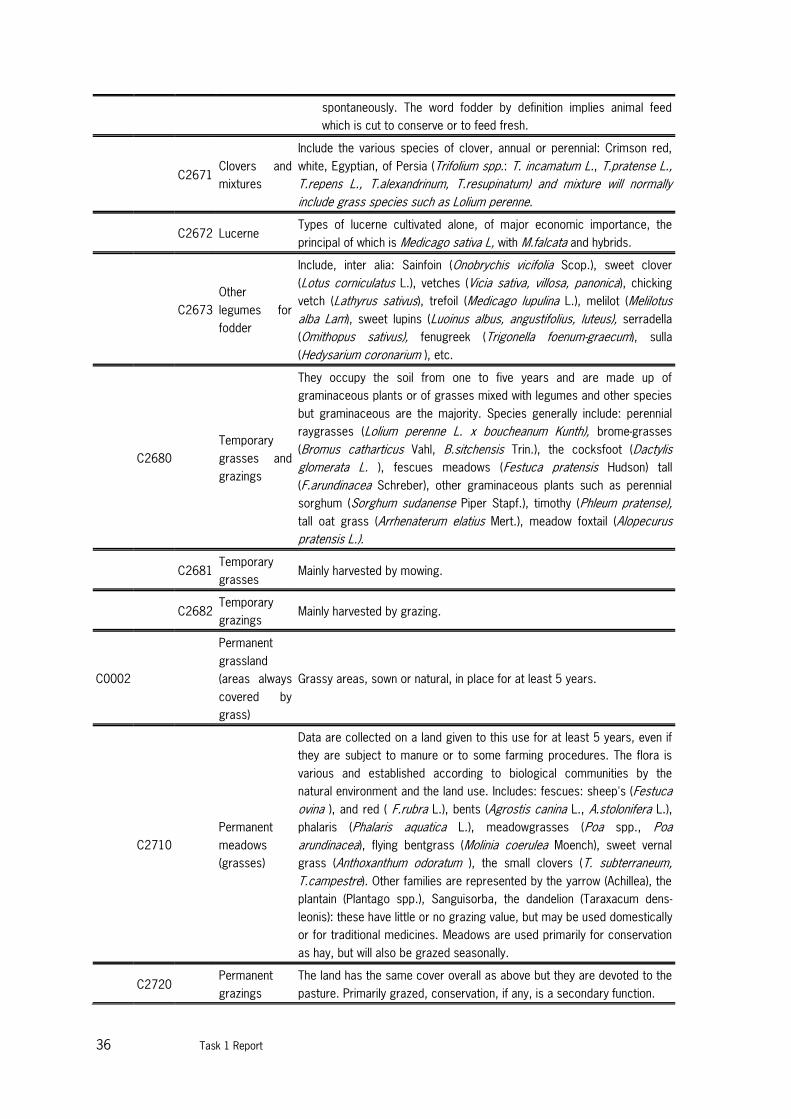
36 Task 1 Report
spontaneously. The word fodder by definition implies animal feed
which is cut to conserve or to feed fresh.
C2671
Clovers and
mixtures
Include the various species of clover, annual or perennial: Crimson red,
white, Egyptian, of Persia (Trifolium spp.: T. incamatum L., T.pratense L.,
T.repens L., T.alexandrinum, T.resupinatum) and mixture will normally
include grass species such as Lolium perenne.
C2672 Lucerne
Types of lucerne cultivated alone, of major economic importance, the
principal of which is Medicago sativa L, with M.falcata and hybrids.
C2673
Other
legumes for
fodder
Include, inter alia: Sainfoin (Onobrychis vicifolia Scop.), sweet clover
(Lotus corniculatus L.), vetches (Vicia sativa, villosa, panonica), chicking
vetch (Lathyrus sativus), trefoil (Medicago lupulina L.), melilot (Melilotus
alba Lam), sweet lupins (Luoinus albus, angustifolius, luteus), serradella
(Omithopus sativus), fenugreek (Trigonella foenum-graecum), sulla
(Hedysarium coronarium ), etc.
C2680
Temporary
grasses and
grazings
They occupy the soil from one to five years and are made up of
graminaceous plants or of grasses mixed with legumes and other species
but graminaceous are the majority. Species generally include: perennial
raygrasses (Lolium perenne L. x boucheanum Kunth), brome-grasses
(Bromus catharticus Vahl, B.sitchensis Trin.), the cocksfoot (Dactylis
glomerata L. ), fescues meadows (Festuca pratensis Hudson) tall
(F.arundinacea Schreber), other graminaceous plants such as perennial
sorghum (Sorghum sudanense Piper Stapf.), timothy (Phleum pratense),
tall oat grass (Arrhenaterum elatius Mert.), meadow foxtail (Alopecurus
pratensis L.).
C2681
Temporary
grasses Mainly harvested by mowing.
C2682
Temporary
grazings Mainly harvested by grazing.
C0002
Permanent
grassland
(areas always
covered by
grass)
Grassy areas, sown or natural, in place for at least 5 years.
C2710
Permanent
meadows
(grasses)
Data are collected on a land given to this use for at least 5 years, even if
they are subject to manure or to some farming procedures. The flora is
various and established according to biological communities by the
natural environment and the land use. Includes: fescues: sheep's (Festuca
ovina ), and red ( F.rubra L.), bents (Agrostis canina L., A.stolonifera L.),
phalaris (Phalaris aquatica L.), meadowgrasses (Poa spp., Poa
arundinacea), flying bentgrass (Molinia coerulea Moench), sweet vernal
grass (Anthoxanthum odoratum ), the small clovers (T. subterraneum,
T.campestre). Other families are represented by the yarrow (Achillea), the
plantain (Plantago spp.), Sanguisorba, the dandelion (Taraxacum dens-
leonis): these have little or no grazing value, but may be used domestically
or for traditional medicines. Meadows are used primarily for conservation
as hay, but will also be grazed seasonally.
C2720
Permanent
grazings
The land has the same cover overall as above but they are devoted to the
pasture. Primarily grazed, conservation, if any, is a secondary function.

Task 1 report 37
C2721 Herbages
Areas devoted to pasture having a rather high yield of about 1500 fodder
units per hectare. They are subject to farming interventions.
C2722
Rough
grazings
Includes grassland areas, moors (grassland areas mixed of bushes as
heathers (Erica, Calluna) or gorses (Ilex)), mountain pastures (alpine or
high altitude pastures used in summer), all extensive pastures often
located in fragile areas. They have low productivity, with yields below
1500 fodder units per hectare. 1500 fodder units meet the needs of one
ABU (adult bovine unit) during 6 months.
3.2.2 FAO country pasture profiles
Similar to the PASK database of JRC there is also a website by FAO18 with country pasture profiles
worldwide. This is an initiative of the Grassland and Pasture Crops Group to make basic information about
the pasture and forage resources of countries available on the internet. Each profile provides a broad
overview of relevant general, topographical, climatic and agro-ecological information with focus on livestock
production systems and the pasture /forage resource.
However, for the EU the coverage is not complete with information being available for only 12 member
states (Belgium, Bulgaria, Czech Republic, Estonia, France, Hungary, Ireland, Latvia, Lithuania, Poland,
Slovakia and United Kingdom).
Each country profile contains the following sections: introduction, soils and topography, climate and agro-
ecological zones, ruminant and livestock production systems, pasture resource, opportunities for
improvement of pasture resource and research and development organizations and personnel. Most
information is descriptive and often tables with some statistics for specific years are included. However, the
level of detail and information varies per country and no standard definitions for grasslands are used.
3.2.3 Biodiversity data centre
The Biodiversity data centre (BDC) managed by the European Environmental Agency (EEA) provides data and
information on species and habitat types of European importance, red listed species in Europe, Natura 2000
sites and nationally designated areas in European countries. At the website of the BDC19 several data
sources and maps can be found. One of the maps is the overview of protected sites in Europe, including
Natura 2000 sites and nationally designated areas (CDDA), see Figure 8. Natura 2000 is the key instrument
to protect biodiversity in the European Union. It is an ecological network of protected areas, set up to
ensure the survival of Europe's most valuable species and habitats. Nationally designated areas is a
European inventory of protected areas designated by the national authorities.
In addition databases are available on the Annex 1 habitat and EUNIS habitat types, which classify amongst
other habitat types the natural and semi-natural grasslands, see also section 4.2.1 and 4.2.2. Data on area
of coverage and in which Natura 2000 site these habitats occur is available.
18 http://www.fao.org/ag/AGP/AGPC/doc/pasture/forage.htm 19 http://biodiversity.europa.eu/data

38 Task 1 Report
Figure 8. Example of mapped protected areas for Spain and Portugal (source EEA)
3.2.4 High Nature Value farmland
JRC/EEA updated the High Nature Value (HNV) farmland indicator (Paracchini, et al., 2008) and in 2012 a
further update of the indicator was produced by the ETC-SIA for the EEA20. The HNV farmland indicator in
this work refers to estimates of the share of agricultural land that is likely to be HNV, the so-called likelihood
score. This assessment is based as much as possible on existing European wide datasets (CLC 2006,
Natura 2000 sites, Important Bird Areas (IBAs), Prime Butterfly Areas (PBAs)). The selection of the classes
per database allocated to HNV farmland are specific per environmental zone. For some countries also
national specific information was used21. As the data is collected at the regional (NUTS 1 / 2) level, maps
can be produced to demonstrate the geographic distribution of HNV farmland in the EU-27 and can be
considered the best proxy for HNV farmland currently. They take account of the different levels of
uncertainty associated with the mapping in different parts of Europe, by illustrating the likelihood of HNV
farmland present. Table 7 provides a summary per country of the most recent estimate of the HNV farmland
likelihood score22.
20 The detailed description of the methodology and the data sources will be published by EEA in 2012: ‘Updated
High Nature Value Farmland in Europe - An estimate of the distribution patterns on the basis of CORINE Land Cover
2006 and biodiversity data’. 21 The methodology applied for the update was the same as that used for the JRC/EEA HNV assessment based on
CLC 2000 (Paracchini et al., 2008). It was based on CORINE land cover data available for the year 2006. It
includes data for Malta that was previously missing and other updated datasets, e.g. the most recent Natura 2000
data. Data for Greece are still missing. 22 The detailed description of the methodology and the data sources will be published by EEA in 2013: ‘Updated
High Nature Value Farmland in Europe - An estimate of the distribution patterns on the basis of CORINE Land Cover
2006 and biodiversity data’.

Task 1 report 39
Table 7. Estimated share of HNV farmland in farmed area Source: EEA, forthcoming
Country1
HNV 2006
farmland area
derived CLC
2006 - ha
Agricultural land
(CLC 2006
agricultural classes
+ HNV areas) - ha
Utilized
agricultural area -
UAA- from
EUROSTAT - ha
Area share of
HNV - %
Austria 2,140,879 3,340,014 3,189,120 64.1
Belgium 435,153 1,780,001 1,374,450 24.4
Bulgaria 2,578,005 6,745,380 3,050,730 38.2
Cyprus 343,209 629,220 146,000 54.5
Czech Republic 1,190,319 4,625,715 3,518,070 25.7
Germany 3,248,177 21,508,158 16,931,890 15.1
Denmark 191,262 3,433,650 2,662,590 5.6
Estonia 531,554 1,605,575 906,830 33.1
Spain 18,820,501 33,698,696 24,834,240 55.8
Finland 1,268,980 2,992,428 2,292,280 42.4
France 8,023,118 35,204,602 27,355,830 22.8
Hungary 1,935,454 6,768,833 4,228,580 28.6
Ireland 1,154,495 5,729,074 4,139,240 20.2
Italy 6,196,451 18,393,993 12,744,200 33.7
Lithuania 640,277 4,011,830 2,648,950 16.0
Luxembourg 13,637 140,317 130,880 9.7
Latvia 569,534 2,848,613 1,773,840 20.0
Malta 1,034 15,666 10,330 6.6
Netherlands 390,551 2,570,614 1,914,320 15.2
Poland 4,488,811 19,750,026 15,477,190 22.7
Portugal 2,854,853 4,881,341 3,357,030 58.5
Romania 5,221,251 14,401,453 13,753,050 36.3
Sweden 1,166,103 4,311,707 3,118,010 27.0
Slovenia 570,551 754,220 488,770 75.6
Slovakia 479,205 2,413,272 1,936,620 19.9
United Kingdom 5,376,637 19,281,655 16,130,520 27.9 1 Data for Greece are not yet available
There are three HNV types distinguished:
Type 1: Farmland with a high proportion of semi-natural vegetation.
Type 2: Farmland with a mosaic of low intensity agriculture and natural and structural elements,
such as field margins, hedgerows, stone walls, patches of woodland or scrub, small rivers etc.
Type 3: Farmland supporting rare species or a high proportion of European or World populations.
As to the role of permanent grassland in the HNV farmland indicator it can be stated that this was not the
purpose of the indicator development. So additional analysis is required to identify the permanent grassland
share and location in this data set. Nevertheless it is clear that HNV farmland indicator could be a helpful
data layer to be used to identify the location of particularly the semi-natural, rough and/or extensive
permanent grassland categories in the EU. First of all it is clear that a majority of the HNV farmland consists
of permanent grassland which is a logical result of the way it is mapped. The land cover approach adopted
for HNV type 1 (and partly type 2) allows an approximation of the localisation of semi-natural vegetation, and
to smaller degree of mosaics of low-intensity agriculture. The land cover classes selection is already
prioritising to grassland and rough grazing areas while the arable mosaic land cover classes only make up a
small proportion of the selected surface. This of course differs per country and environmental zone in the
EU. In order to cover HNV type 3, information is needed on the location of farmland which supports rare
species or a high proportion of European or World populations. This is gathered from various sources in
which again the permanent and rough grazing areas dominate:

40 Task 1 Report
1. NATURA 2000 network, which provides information on protected sites that support rare,
endangered or vulnerable natural habitats and species of plants or animals (areas designated under
the Habitats Directive) and areas supporting significant numbers of wild birds and their habitats
(protected sites designated under the Birds Directive). From the Natura 2000 sites in the EU-25,
only those have been selected for which at least one Annex I habitat type related to agricultural
activities is recorded. The overall selection comprises 11,293 sites that cover a total of 534,867
km2 in the EU-25. Once the Natura 2000 sites had been selected, relevant agricultural areas within
the site boundaries were mapped on the basis of agricultural CORINE Land Cover classes. This
approach was also applied to IBAs and PBAs.
2. Important Bird Areas (IBAs), which provide information on significant populations of one or more
globally or regionally threatened, endemic or congregatory bird species, or highly representative
bird assemblages. Data are compiled by BirdLife International and Partners. Important Bird Areas
are identified on the basis of standard criteria agreed by the international BirdLife network. In
Europe, the criteria take into account the requirements of regional conservation treaties such as
the Emerald Network under the Bern Convention, the Helsinki Convention, the Barcelona
Convention, as well as the Wild Birds Directive of the European Union.
3. Prime Butterfly Areas (PBAs) (Van Swaay and Warren 2003), which are an initial selection of
important butterfly areas in Europe, focussing on target species that are conservation priorities
across the European continent, and including both marginal and core populations.
4. National biodiversity datasets (when made available and suitable for inclusion). These refer
mainly to national inventories of agricultural biotopes or semi-natural grasslands (e.g. in the Czech
Republic, Sweden, Estonia, Lithuania and England). These have been added where national patterns
of HNV farmland could not be captured by the presented land cover approach. An example of this
is the parcels of semi-natural grasslands scattered through forested environments in the Nordic
countries.
In all the data sets used the permanent grassland coverage is mostly dominating. This is also further
enhanced by the national specific corrections that were applied once the selection of the EU wide data
sources was made in the process of producing the HNV farmland indicator.
Figure 9. HNV Farmland areas 2012 update based on CLC 2006 data (Paracchini et al., 2008)

Task 1 report 41
In order to use the HNV farmland map to derive the location of low input grassland areas one could
overlay it with the HNV grassland and rough grazing categories to identify them spatially. Within the
Natura 2000 areas there is also the possibility to select the mapped sites that refer to an Annex I site
Annex I habitat type related to agricultural grassland activities.
3.3 Remote sensing based sources
In the sections below the following remote sensing based sources of grassland information are discussed:
GlobCover, Global Land Cover 2000, CORINE, GIO HR grassland and Geoland2 HR grassland. Besides these
sources other global land cover maps are available as well, such as the IGBP land cover map, the AVHRR
Global Land Cover Classification by the University of Maryland and the USGS Global Land Cover
Characteristics Data Base. However, these sources are based on remote sensing data from before 2000
and have not been updated anymore. Therefore we focus only on the most recent and Europe specific
sources.
3.3.1 GlobCover
The GlobCover Land Cover Map was created by the ESA’s GlobCover Project. The map displays land
classification information for most of the Earth’s surface at a resolution of 300 meter (9 ha per pixel) and
contains 22 different land cover types, which are based on the predominant type of vegetation found at that
location. The data was collected from the MERIS sensor on the ENVISAT satellite during 2009. There is also
an older map, the Global Land Cover Product from the period 2005-2006. Both maps can be obtained from
the ESA GlobCover website23.
Figure 10.GlobCover database for the year 2009
GlobCover legend:
- 10 Rainfed croplands
- 11 Post-flooding or irrigated croplands
- 13 Post-flooding or irrigated croplands
23 http://ionia1.esrin.esa.int/

42 Task 1 Report
- 14 Rainfed croplands
- 20 Mosaic cropland (50-70%) /vegetation (grassland/shrubland/forest) (20-50%)
- 30 Mosaic vegetation (grassland/shrubland/forest) (50-70%) / cropland (20-50%)
- 40 Closed to open (>15%) broadleaved evergreen and/or semi-deciduous forest (>5m)
- 50 Closed (>40%) broadleaved deciduous forest (>5m)
- 60 Open (15-40%) broadleaved deciduous forest/woodland (>5m)
- 70 Closed (>40%) needle-leaved evergreen forest (>5m)
- 90 Open (15-40%) needle-leaved deciduous or evergreen forest (>5m)
- 100 Closed to open (>15%) mixed broadleaved and needleaved forest
- 110 Mosaic forest or shrubland (50-70%) and grassland (20-50%)
- 120 Mosaic grassland (50-70%) and forest or shrubland (20-50%)
- 130 Closed to open (>15%) shrubland (<5m)
- 140 Closed to open (>15%) grassland
- 150 Sparse (<15%) vegetation
- 160 Closed (>40%) broadleaved forest regularly flooded, fresh water
- 170 Closed (>40%) broadleaved semi-deciduous and/or evergreen forest regularly flooded, saline
water
- 180 Closed to open (>15%) grassland or shrubland or woody vgt on regularly flooded or
waterlogged soil, fresh, brakish or saline water
- 190 Artificial surfaces and associated areas (Urban areas >50%)
- 200 Bare areas
- 210 Water bodies
- 220 Permanent Snow and Ice
- 230 no data
The global Globcover legend is compatible with the GLC2000 global land cover classification (http://www-
tem.jrc.it/glc2000/legend.html) and the Land Cover Classification System (LCCS) developed by FAO (see
Section 0). Grassland is mapped in mosaic/composite land cover classes 20, 30, 110 and 120 (+ 140).
3.3.2 GLC2000
The global land cover data for the year 2000 (GLC2000) project24, coordinated by the European Joint
Research Centre (JRC), provides consistent global land cover information for the year 2000. The GLC2000
project followed a bottom-up approach to map world’s land cover. The global land cover map was derived by
merging 18 regional products made by regional experts. Consistency between the regional products was
derived by classifying SPOT4-Vegetation dataset (spatial resolution 1km) and applying the land cover
classification system (LCCS) produced by the United Nations (UN) (Di Gregorio, 2005). After harmonization
and merging the individual regional products one global GLC2000 product with a generalized legend was
produced (Bartholomé and Belward, 2005). The GLC2000 database has 22 classes (see Table 8 and Figure
11).
24 http://bioval.jrc.ec.europa.eu/products/glc2000/glc2000.php

Task 1 report 43
Figure 11.The Global Land Cover dataset for the year 2000 (GLC2000)
Table 8. GLC2000 legend aggregated from regional classes using LCCS
Nr. GLC Global Class (according to LCCS terminology)
1 Tree Cover, broadleaved, evergreen
LCCS >15% tree cover, tree height >3m
(Examples of sub-classes at regional level: closed > 40% tree cove; open 15-40% tree cover)
2 Tree Cover, broadleaved, deciduous, closed
3 Tree Cover, broadleaved, deciduous, open
(open 15-40% tree cover)
4 Tree Cover, needle-leaved, evergreen
5 Tree Cover, needle-leaved, deciduous
6 Tree Cover, mixed leaf type
7 Tree Cover, regularly flooded, fresh water (& brackish)
8 Tree Cover, regularly flooded, saline water,
(daily variation of water level)
9 Mosaic: Tree cover / Other natural vegetation
10 Tree Cover, burnt
11 Shrub Cover, closed-open, evergreen
(Examples of sub-classes at reg. level: (i) sparse tree layer)
12 Shrub Cover, closed-open, deciduous
(Examples of sub-classes at reg. level: (i) sparse tree layer)
13 Herbaceous Cover, closed-open
(Examples of sub-classes at regional level: (i) natural, (ii) pasture, (iii) sparse trees or shrubs)
14 Sparse Herbaceous or sparse Shrub Cover

44 Task 1 Report
3.3.3 CORINE land cover
The CORINE (CO-oRdination of INformation on the Environment) programme was initiated by the EU in 1985.
A number of databases were created within this framework with the aim to give information on the status
and changes of the environment. One of these databases is the CORINE Land Cover database (CLC). Up to
now three maps have been produced (1990, 2000 and 2006) and the fourth (2012) is currently under
development. Feranec et al. (2012) presents an overview of land cover and its change in Europe for the
period 1990-2006 based on the CLC maps.
CLC 1990
The reference year for this database is 1990 (range 1986 – 1995) and its geographical extent covers 24
countries (most of the EU-27, except Sweden, Finland and United Kingdom) 25. The land cover information is
derived from high resolution satellite data (Landsat-TM) by computer assisted visual interpretation in
combination with ancillary data. The minimum mapping unit is 25 ha and for line elements the minimum width
is 100m. The scale of the land cover database is 1:100.000.
CLC 2000
The reference year for this database is 2000 (range 1999 - 2001) and its geographical extent covers all EU
27 and countries belonging to EFTA4 and EEA3226. The land cover is derived from the Landsat-7 ETM single
date satellite data. The basic parameters of CLC2000 are the same as those of CLC 1990 inventory (i.e.
minimum mapping unit of 25 hectares, minimum width of linear elements: 100 metres and standard CLC
nomenclature). This data set has been widely used for many environmental assessments and policy driven
research questions, see e.g. Figure 12. Dominant landscape types in Europe based on CLC 2000Figure 12.
25 http://www.eea.europa.eu/data-and-maps/data/corine-land-cover-clc1990-100-m-version-12-2009 26 http://www.eea.europa.eu/data-and-maps/data/corine-land-cover-2000-raster-2
15 Regularly flooded Shrub and/or Herbaceous Cover
16 Cultivated and managed areas
(Examples of sub-classes at reg. level: (i) terrestrial; (ii) aquatic (=flooded during cultivation), and under
terrestrial: (iii) tree crop & shrubs (perennial), (iv) herbaceous crops (annual), non-irrigated, (v)
herbaceous crops (annual), irrigated)
17 Mosaic: Cropland / Tree Cover / Other natural vegetation
18 Mosaic: Cropland / Shrub or Grass Cover
19 Bare Areas
20 Water Bodies (natural & artificial)
21 Snow and Ice (natural & artificial)
22 Artificial surfaces and associated areas
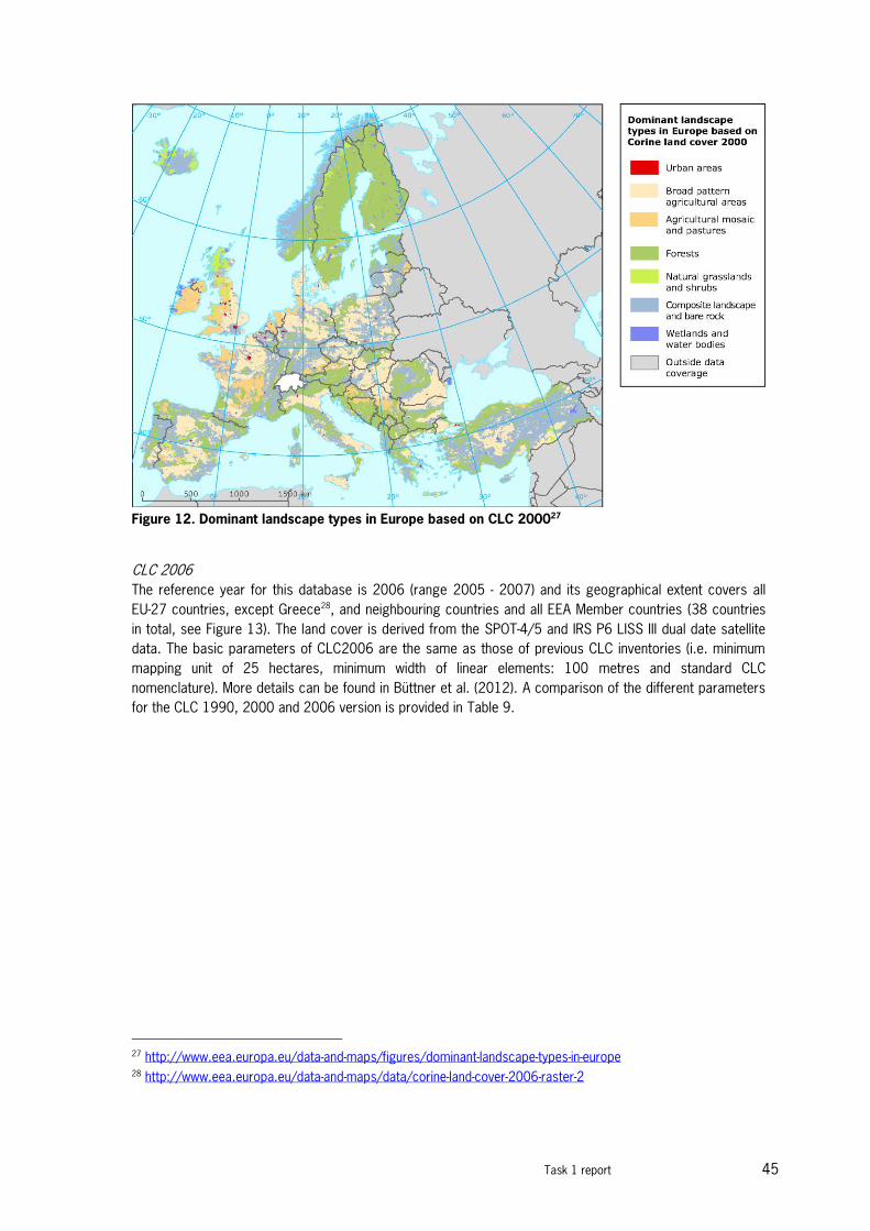
Task 1 report 45
Figure 12. Dominant landscape types in Europe based on CLC 200027
CLC 2006
The reference year for this database is 2006 (range 2005 - 2007) and its geographical extent covers all
EU-27 countries, except Greece28, and neighbouring countries and all EEA Member countries (38 countries
in total, see Figure 13). The land cover is derived from the SPOT-4/5 and IRS P6 LISS III dual date satellite
data. The basic parameters of CLC2006 are the same as those of previous CLC inventories (i.e. minimum
mapping unit of 25 hectares, minimum width of linear elements: 100 metres and standard CLC
nomenclature). More details can be found in Büttner et al. (2012). A comparison of the different parameters
for the CLC 1990, 2000 and 2006 version is provided in Table 9.
27 http://www.eea.europa.eu/data-and-maps/figures/dominant-landscape-types-in-europe 28 http://www.eea.europa.eu/data-and-maps/data/corine-land-cover-2006-raster-2

46 Task 1 Report
Figure 13. Corine Land Cover map 2006
Table 9. Evolution CORINE Land Cover projects (Büttner et al., 2012).
Parameter CLC 1990 CLC 2000 CLC 2006
Main satellite data Landsat-4&5 MSS/TM
single date
Landsat-7 ETM
single date
SPOT-4/5 and
IRS P6 LISS III
dual date
Time consistency 1986-1998 2000 +/- 1 year 2006+/- 1 year
Geometric accuracy
satellite images
≤ 50 m ≤ 25 m ≤ 25 m
CLC mapping min.
mapping unit/width
25 ha/ 100m 25 ha/ 100m 25 ha/ 100m
Geometric accuracy
CLC data
100 m better than 100 m better than 100 m
Thematic accuracy ≥ 85% (probably not
achieved)
≥ 85%
(achieved [6])
≥ 85%
(not checked)
Change mapping not implemented boundary displacement
min. 100 m; change area
for existing polygons ≥ 5
ha; for isolated changes ≥
25 ha
boundary displacement
min.100 m;
all changes > 5 ha are to
be mapped
Production time 10 years 4 years planned: 1.5 years
realised: 3.0 years
Documentation incomplete metadata standard metadata standard metadata
Access to the data unclear dissemination
policy
dissemination policy
agreed from the start
free access for all kinds
of users (CLC data)
Number of European
countries involved
26 30 38

Task 1 report 47
Used definitions and classification
The final CLC database consists of a geographical database describing land cover/use in 44 classes
grouped into a three level hierarchical structure. The CORINE land cover nomenclature has 5 major
categories at the first level, 15 land cover categories at the second level and 44 categories at the third
level. More information is provided in Section 4.1.7 and in Annex 1 examples for the different pasture types
are provided.
3.3.4 GIO HR grassland
GIO HR stands for GMES (Global Monitoring for Environment and Security) Initial Operations High Resolution.
A high resolution data set of permanent grassland will be produced. The analysis will use the three reference
years (2006, 2009, 2012) to detect the permanent presence of grassland. The discrimination of permanent
grassland from other agricultural land areas such as arable land, bare soil, needs to take into account
seasonal variations. A minimum of 3 (worst case), an average of 4-5 and up to maximum 8 seasonal images
of AWiFS data (reference year 2012) will be used as additional information for the classification process.
Resolution will be 20 m x 20 m, and statistical validation will be carried out on the 100 m x 100 m data.
Required minimum accuracy is 80%.
Grassland is defined as ground covered by vegetation dominated by grasses and other herbaceous plants
with dominantly agriculture use. Grassland includes the following landscape types:
- Pastures, grassland used for grazing or hay production (CLC classes 2.3.1, but also appears in
classes 2.1.1 to 2.4.4).
- Cultivated or semi-natural grassland within forests, and grass covered surfaces with-in transitional
woodland (appears in CLC classes 3.1.1-3.1.3, 3.2.4).
- Natural grassland in any surrounding (CLC class 3.2.1).
- Grassy areas with low (10%) fraction of scattered trees and shrubs.
- Alpine meadows with low fraction of bare rock or gravel.
Land covers not to be considered as grassland:
- Grassland in urban areas: parks, urban green in residential and industrial areas.
- Grass surfaces in sport and recreation areas, incl. golf courses.
- Clearcut areas, new forests.
- Areas of shrubs: areas dominated by moors and heathland (Atlantic, CLC class 3.2.2) or
sclerophyllous vegetation (Mediterranean, CLC class 3.2.3).
- Surfaces covered exclusively by mosses and lichen (Subarctic).
- Peatland (either in natural condition or in excavation, CLC class 4.1.2).
3.3.5 Geoland2 HR Grassland
Within the GMES initiative (Global Monitoring for Environment and Security) the Land Services provide cross-
border harmonised geo-information at global to local scales in a time- and cost-effective manner. Building
upon previous project, Geoland2 aims to organise a qualified production network, to build, validate and
demonstrate operational processing lines and to set-up a user driven product quality assurance process.
One of the core mapping services is EUROLAND which provides land cover, land use and land cover change
data. EUROLAND addresses both the local and the continental component (i.e. high spatial resolution, wall-
to-wall land cover parameters and land cover change).
The concept and product specifications are based on the latest consolidated user requirements (on a high
common European level) for high resolution (HR) layers as presented in the project and service
48 Task 1 Report
specifications29. For the HR grassland layer, a multi-criteria approach is requested for characterisation. This
approach would lead to a GL mask, which is being subdivided according to the following four criteria:
- Wetness,
- Intensity of use,
- Mixture with high vegetation elements, and
- Cover density (grass)
Based on feasibility criteria of the earth observation (EO) based approach, the developed overall concept will
serve the following layers:
- A grass surface indicator (primary probability layer),
- A grass surface mask (secondary layer),
- An arable land mask (annual crops),
plus the following intensity layers (secondary layers), specified and described in detail below:
- Shrub and trees indicator (corresponding to “Mixture with high vegetation elements”),
- Grass density indicator (corresponding to “Cover density”), and
- Cutting indicator (addressing “Intensity of Use”).
The maps will be at high resolution of 60 m x 60 m pixels, based on AWiFS data with a minimum mapping
unit of 1 ha. Only the AWIFS data provide currently the necessary multi-temporal data coverage for an
economic price – about 4 to 6 dates are necessary, depending on the significance in the vegetation season.
The Geoland2 HR grassland layer has so far only been produced for three case study areas in Germany,
Austria and Greece30.
Definition of the Primary product - Grass Surface Indicator (EL-01a1)
The Grass surface indicator is a thematic map that shows continuous EO-defined probability (1-100%) of
grass surface occurrence, typically aggregated to discrete percent classes. The map is produced by help of
multi-temporal EO derived supporting data sets and other HR Layers, i.e. Soil sealing, Forest area map and
Water map. The indicator provides information about the spatial extent of grass covered surfaces. The
probability degrees derived for this layer reflect the level of resemblance of each pixel to the expected
spectral-phenological behaviour of grass surfaces. E.g., extreme temporal variability of the spectral
vegetation response may point to an arable area rather than grass surface, which can be expected to be
more steadily vegetated throughout the year (in humid temperate climate). In this respect, geographically
(climate, soils, elevation, etc.) induced variability of grassy surfaces throughout the year will be taken into
account by means of an eco-region based stratification.
Grass surfaces captured in this layer contain grassland and grassy surfaces of any use and management,
e.g. pasture, cultivated meadows, lawn used for sports, etc., together with grass surfaces with shrub and
trees present. The layer itself does now allow for distinguishing different habitats. According to the
conceptual approach, the specification of grass surface layer is limited with regard to built-up areas and
forest. The forest and build-up land cover classes have been excluded from the processing, even though
there may be grass covered surfaces under the tree canopy or in between the trees (regarding low forest
cover) or the buildings. On the other hand, the Grass surface indicator includes areas across a broad
probability range, meaning that pure grassy surfaces and surfaces with partially “grassy behaviour” are
contained in the layer.
29 http://www.gmes-geoland.info/project-documentation/product-service-specifications.html 30 http://www.geoland2.eu/portal/service/ListService.do?serviceCategoryId=CA80C481

Task 1 report 49
Nomenclature:
Grass Surface Indicator
- Covering areas with vegetation of full or partial grass-like phenological behaviour (site-specific) that
does not belong to forests and built-up areas
- mapped in continuous probability percent (1-100%) that can be aggregated to discrete map and
such suit different customer needs
- pixel-based product (60 m)
- Linear (e.g. roads) features are included if smaller than the defined MMU
Definition of the Secondary product - Grass Surface Mask (EL-01b1)
The grass Surface mask is derived as a binary layer from the Grass Surface probability map via thresholding
the probability levels. The determination of the appropriate threshold is evolving during production and
cannot be specified a prior. It can be defined that the layer covers areas where grass constitutes the
dominant surface (>50%). The Grass Surface Mask is the spatial framework for the set of intensity layers for
the further characterisation of grassy surfaces (Shrub and trees, Grass density, and Cutting indicator). That
means, these indicators will be derived within the Grass Surface Mask only.
Nomenclature:
Grass Surface Indicator
- Grass area mask includes: grass dominant (>50%) surfaces, pastures, cultivated meadows, lawn
used for sports, together with grass surfaces with shrub and trees present
- Pixel-based product (60 m), the grass area mask is mapped with 1 ha minimum area / 60 m width
Definition of the Secondary Grassland product - Grass Vegetation Density Indicator (EL-01b4)
The Grass Vegetation Density Indicator provides information on grass vegetation density, the maximum of
Leaf Area Index – LAI (m2/m2) during vegetation period, within the Grass Surface mask.
The Grass Vegetation Density Indicator is derived from biophysical EO parameter LAI that differentiate
vegetation according to their leaf area cover, the leaf density. On a regional scale, it allows separating areas
of high(er) from low(er) grass vegetation density. In as much as intensely managed grass parcels have
potentially higher vegetation productivity compared to less intensely managed or natural grass surfaces, this
indicator is also related to the intensity of grass management. Local/regional environmental conditions play
an important role for the indicator, hence regional contextual interpretation of the indicator is required.
Nomenclature:
Grass Vegetation Density Indicator
- Mapped in relative density values 0-100, which correspond to Leaf Area Index (m2/m2)
- Can be aggregated to discrete ranges and thus be customised
- pixel-based product (60 m)
- 1 ha minimum area / 60 m width is inherited in the indicator from the Grass Surface mask area
-
Definition of the Secondary Grassland product - Cutting Indicator (EL-01b5)
The Cutting Indicator provides information on grass cutting and/or grazing on a relative scale from 0 to
100% within the Grass Surface area mask. The values refer to the intensity and/or frequency of green
vegetation biomass change during main vegetation period. The Cutting Indicator is derived from multi-

50 Task 1 Report
temporal EO parameters that show the biomass changes during the main vegetation period. The proper
calculation of this indicator is highly sensitive to availability of frequent multi-temporal EO images, especially
during the high vegetation period. This indicator aims at detecting presence of cutting, but also grazing that
is not separated as different management. The separation of the two ways of agricultural uses and its
combination is practically not possible. The cutting indicator is a partial indicator for the intensity of use of
the grass covered areas.
Nomenclature:
Cutting Indicator
- Mapped in relative intensity values 0-100%
- Can be aggregated to discrete percent ranges and thus be customised
- pixel-based product (60 m)
- 1 ha minimum area / 60 m width is inherited in the indicator from the Grass Surface mask area
3.4 Analysis of possible sources of grassland data
This Chapter will analyse and compare the different sources of grassland data that are available at European
level. Table 10 provides an overview of the characteristics of the main data sources that were discussed in
the previous sections. In

Task 1 report 51
Table 11 we have assessed the grassland data sources for several criteria which determine the usefulness
for data collection on grasslands to create a coherent European dataset that serves European policy needs.
White indicates that the data source has a high potential when evaluated against the criterion, grey a
moderate potential and black a low potential.
The following criteria were included: clear harmonized definitions, spatial coverage, spatial resolution,
temporal coverage, temporal resolution, grassland productivity data and availability. The ‘clear harmonized
definitions’ refer to the presence of clear and distinct definitions and / or classification for grasslands that
are used in a harmonized manner within the EU countries. Spatial coverage refers to the number of EU
countries that are included, while spatial resolution refers to the scale at which the data is collected (e.g.
field or farm scale or national scale). Temporal coverage refers to the number of years for which the data is
available, while temporal resolution refers to the frequency of data collection, e.g. every year or less
frequent. Grassland productivity refers to the availability of productivity data in the data source and
availability refers to accessibility (e.g. public available) as well as easiness to obtain the data (e.g. easy
downloadable, completeness of data records).

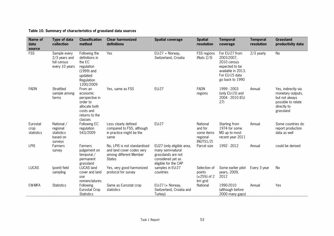
Task 1 Report 53
Table 10. Summary of characteristics of grassland data sources
Name of
data
source
Type of data
collection
Classification
method
Clear harmonized
definitions
Spatial coverage Spatial
resolution
Temporal
coverage
Temporal
resolution
Grassland
productivity data
FSS Sample every 2/3 years and full census every 10 years
Following the definitions in the EC regulation
(1999) and
updated Regulation 1200/2009
Yes EU-27 + Norway, Switzerland, Croatia
FSS regions (Nuts 2/3)
For EU-27 from 2003-2007, 2010 census expected to be available in 2013. For EU-15 data go back to 1990
2/3 yearly No
FADN Stratified sample among farms
From an economic perspective in order to allocate both costs and returns to the classes
Yes, same as FSS EU-27 FADN regions
1999 - 2003 (only EU-15) and 2004 - 2010 (EU-27)
Annual Yes, indirectly via monetary outputs, but not always possible to relate directly to grassland
Eurostat crop statistics
National / regional statistics based on surveys
Following EC regulation 543/2009
Less clearly defined compared to FSS, although in practice might be the same
EU-27 National and for some items regional (NUTS1/2)
Starting from 1974 for some MS up to most recent year 2011
Annual Some countries do report production data as well
LPIS Farmers survey
Farmers judgement on temporal / permanent grassland
No, LPIS is not standardised and land cover codes very among different Member States
EU27 (only eligible area, many semi-natural grasslands are not considered yet as eligible for the CAP
Parcel size 1992 - 2012 Annual could be derived
LUCAS (point) field sampling
LUCAS land cover and land use nomenclatures
Yes, very good harmonized protocol for survey
samples in EU-27 countries
Selection of points (±25%) of 2 km grid
Some earlier pilot years, 2009, 2012
Every 3 year No
EW-MFA Statistics Following Eurostat Crop Statistics
Same as Eurostat crop statistics
EU-27 (+ Norway, Switzerland, Croatia and Turkey)
National 1990-2010 (although before 2000 many gaps)
Annual Yes

54 Task 1 Report
Name of
data
source
Type of data
collection
Classification
method
Clear harmonized
definitions
Spatial coverage Spatial
resolution
Temporal
coverage
Temporal
resolution
Grassland
productivity data
FAOSTAT National statistics
Following FAOSTAT definitions
Yes, clear and elaborated definitions are used
Global National 1961 - 2009 Annual No
UNFCCC Country specific, combination of statistics and RS
Country specific, combination of statistics and RS
No, although the IPCC guidelines provide default definitions, most MS use their own definition
Annex 1 countries, incl. EU member states, except Malta and Cyprus
National 1990-2010 Annual No
OECD National statistics
Following FAOSTAT
Same as FAOSTAT but less extensive
OECD countries National 1990-2004 Annual Yes
PASK study Statistics Statistics and description
No, although (an old) Eurostat definition is used, most data are based on national classifications
EU-27 (+ Turkey) National Trend till 2002, starting year differs per country
Single review of statistics in 2003
For some countries and some fodder crops
GlobCover Satellite derived
Semi-automatic No, satellite derived and based on land cover with several mixed classes
global 300 m grid cell
2009 Once No
GLC2000 Satellite derived
Semi-automatic No, satellite derived and based on land cover with several mixed classes
global 1 km grid cell
2000 Once No
CORINE land cover
Satellite derived
Visual/semi-automatic
Good classification scheme, but some mixed classes and remains mainly satellite derived
EEA32+ for 2012, for previous years less countries, EU-27 MS were all included except for 1990 (Sweden and Finland missing)
100 m grid cell
1990, 2002, 2006, 2012
Several years No
GIO HR grassland
Satellite derived
Semi-automatic Same as CORINE land cover EEA32+ 20 m grid cell
2006-2012 Once No
Geoland2 HR Grassland
Satellite derived
Semi-automatic No, based on different earth observation techniques with sometimes gradual classes
In principal for EEA32+, currently only for some case study areas
60 m grid cell
2006 Once No

Task 1 report 55
Table 11. Assessment grassland data sources (white is good, grey medium and black bad performance on criteria)
Name of data source Clear
harmonized
definitions
Spatial
coverage
Spatial
resolution
Temporal
coverage
Temporal
resolution
Grassland
productivity
data
Availability
FSS
FADN
Eurostat crop statistics
LPIS
LUCAS
EW-MFA
FAOSTAT
UNFCCC
OECD
PASK study
GlobCover
GLC2000
Corine Land Cover
GIO HR grassland
Geoland2 HR Grassland
The assessment as presented in

56 Task 1 Report
Table 11 shows that there is no data source that scores well on all criteria. In general the remote sensing based sources have a low score on criteria as clear and harmonized
definitions, the temporal coverage and resolution and the lack of data on grassland productivity. The statistical sources perform lower on the spatial resolution and most also
lack data on data on grassland productivity. FSS and FADN statistics score both well, only FSS is lacking the grassland productivity data and has not an annual frequency. LPIS
data only score bad at the clear harmonized definitions and on the public availability aspect. However, both could be improved with Eurostat support, which would make this a
very valuable data source. When detailed grassland locations are needed the Corine Land Cover map and related products are most useful, while LUCAS is more valuable for
general and regional trends in grassland areas and use, as this is the grassland data source that is most harmonized among EU member states.
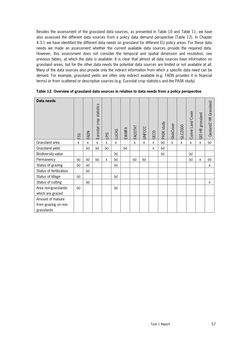
Task 1 Report 57
Besides the assessment of the grassland data sources, as presented in Table 10 and Table 11, we have
also assessed the different data sources from a policy data demand perspective (Table 12). In Chapter
4.3.1 we have identified the different data needs on grassland for different EU policy areas. For these data
needs we made an assessment whether the current available data sources provide the required data.
However, this assessment does not consider the temporal and spatial dimension and resolution, see
previous tables, at which the data is available. It is clear that almost all data sources have information on
grassland areas, but for the other data needs the potential data sources are limited or not available at all.
Many of the data sources also provide only the indirect information from which a specific data need can be
derived. For example, grassland yields are often only indirect available (e.g. FADN provides it in financial
terms) or from scattered or descriptive sources (e.g. Eurostat crop statistics and the PASK study).
Table 12. Overview of grassland data sources in relation to data needs from a policy perspective
Data needs
FSS
FA
DN
Eur
ost
at
cro
p s
tatist
ics
LPIS
LU
CAS
EW
-MFA
FA
OS
TAT
U
NFC
CC
O
EC
D
PAS
K s
tudy
G
lobC
ove
r
G
LC
200
0
C
orine
Land
Cove
r
G
IO H
R g
rass
land
G
eola
nd2
HR G
rass
land
Grassland area x x x x x x x x (x) x x x x (x)
Grassland yield (x) (x) (x) (x) x (x)
Biodiversity value (x) (x) (x)
Permanency (x) (x) (x) x (x) (x) (x) (x) x (x)
Status of grazing (x) (x) (x) x
Status of fertilization (x)
Status of tillage (x) (x)
Status of cutting (x) x
Area non-grasslands
which are grazed
(x) (x)
Amount of manure
from grazing on non-
grasslands

58 Task 1 Report

Task 1 report 59
4 Review on current definitions and
classifications of grassland
4.1 Overview different definitions and classifications
The definition of land cover is fundamental, because in many existing classifications and legends it is
confused with land use. Land cover is the observed (bio)physical cover on the earth's surface. Land use is
characterized by the arrangements, activities and inputs people undertake in a certain land cover type to
produce, change or maintain it. Definition of land use in this way establishes a direct link between land cover
and the actions of people in their environment. For example, "grassland" is a cover term, while "rangeland" or
"tennis court" refer to the use of a grass cover (Di Gregorio, 2005). In general data sources derived by
remote sensing refer to land cover, while statistical sources refer to land use.
An often cited definition is from White et al. (2000), who defined grasslands as terrestrial ecosystems
dominated by herbaceous and shrub vegetation and maintained by fire, grazing, drought and/or freezing
temperatures. This is a broad definition that encompass not only non-woody grasslands but also savannas,
woodlands, shrublands, and tundra. The focus of their study was on global scale mapping of grasslands and
a strong emphasis on (semi) natural grasslands. Below we present an overview of different definitions and
classifications of grassland that focus more on the European and agricultural context.
4.1.1 International terminology for grazing lands and grazing animals
In 1991, Terminology for Grazing Lands and Grazing Animals was published with the objective of ‘developing
a consensus of clear definitions of terms used in the grazing of animals.’ This first effort involved primarily
organizations and agencies within the USA but included representation from New Zealand and Australia. In
2000, Terminology became the first project to be jointly supported by the International Grassland Congress
(IGC) and the International Rangeland Congress (IRC). In 2010 this resulted in a completed revision of the
terminology, which was published in 2011 in the journal of Grass and Forage Science (Allen et al. 2011).
It is intended that these terms enhance communication in education, science, industry and production and
that they become the standard for use in publications. The most relevant terms related to grassland
definitions are stated below, the complete list can be found in Allen et al. (2011).
Grazing land. Any vegetated land that is grazed or has the potential to be grazed by animals (domestic and
wild). This term is all-inclusive and covers all kinds and types of land that can be grazed.
Pastureland. Land (and the vegetation growing on it) devoted to the production of introduced or indigenous
forage for harvest by grazing, cutting, or both. Usually managed to arrest successional processes
Grassland. The term ‘grassland’ is synonymous with pastureland when referring to an imposed grazing-land
ecosystem. The vegetation of grassland in this context is broadly interpreted to include grasses, legumes
and other forbs, and at times woody species may be present.
Annual pastureland ⁄ grassland. Forage is established annually, usually with annual plants, and generally
involves soil disturbance, removal of existing vegetation, and other cultivation practices.

60 Task 1 Report
Cultivated pastureland ⁄ grassland. Forage is established with domesticated introduced or indigenous
species that may receive periodic cultural treatment such as renovation, fertilization or weed
control.
Permanent pastureland ⁄ grassland. Land on which vegetation is composed of perennial or self-seeding
annual forage species which may persist indefinitely. It may include either naturalized or cultivated forages.
Temporary pastureland ⁄ grassland. Land on which vegetation is composed of annual, biennial, or
perennial forage species kept for a short period of time (usually only a few years).
Note: Temporary pastureland ⁄ grassland can be regularly resown or can be integrated in a crop rotation (ley). It is
usually composed of simple mixtures of grasses, grass ⁄ legume or legume species.
Ley. Temporary pastureland ⁄ grassland that is integrated in a crop rotation.
Naturalized pastureland ⁄ grassland. Forage species present are primarily introduced from other
geographical regions that have become established and have persisted under the existing conditions of
environment and management over a long time.
Semi-natural pastureland ⁄ grassland. Managed ecosystem dominated by indigenous or naturally
occurring grasses and other herbaceous species (cf. Native grassland).
Meadow. A natural or semi-natural grassland often associated with the conservation of hay or silage.
Note: A meadow may exist as a result of discontinuous features of hydrology, landscape position, or soil
characteristics that differ from the surrounding landscape and vegetation. Descriptive terms include ‘mountain
meadow,’ ‘alpine meadow,’ ‘wet meadow,’ and ‘hay meadow.’ ‘Flower meadows’ are kept for aesthetic interest and can
also provide feeding or bedding.
Rangeland. Land on which the indigenous vegetation (climax or sub-climax) is predominantly grasses,
grass-like plants, forbs or shrubs that are grazed or have the potential to be grazed, and which is used as a
natural ecosystem for the production of grazing livestock and wildlife.
Note: Rangelands may include natural grasslands, savannas, shrublands, many deserts, steppes, tundras, alpine
communities and marshes.
Native or natural grassland. Natural ecosystem dominated by indigenous or naturally occurring grasses
and other herbaceous species used mainly for grazing by livestock and wildlife.
Note: There are many types of natural grasslands, with vegetation characteristics determined by climate and soil
conditions, by grazing animals and by fire. Examples of local ⁄ regional variations follow. Geographical regions where
examples may be found are provided in parentheses following the definition. This is not an all-inclusive list of grassland
types or of locations in which they are found but provides some examples.
Marshland. Flat, wet, treeless wetland usually covered by shallow water and dominated by marsh grasses,
rushes, sedges, other grass-like plants and forbs.
Shrubland. Land on which the vegetation is dominated by low-growing woody plants
Tundra. Land areas in arctic and alpine regions devoid of large trees, varying from bare ground to various
types of vegetation consisting of grasses, sedges, forbs, dwarf shrubs and trees, mosses and lichens.

Task 1 report 61
4.1.2 Common Agricultural Policy
The EU needed a clear and simple definition of permanent grassland in the framework of their subsidization
policy. In 2004 the EU defined permanent grassland as: land used to grow grasses or other herbaceous
forage naturally (self-seeded) or through cultivation (sown) and that is not included in the crop rotation of the
holding for five years or longer (Commission Regulation EU No 796/2004). Before the EU definition,
permanent grassland was defined in vague terms. It was an area with grass as a continuous crop for a
relatively long to very long time, with or without resowing. Reheul et al. (2007) provide an overview of
definitions used by several member states for permanent and temporary grassland, before the EU definition
was set. This shows that definitions varied widely among countries, especially regarding the time of being
part of the rotation.
Definition for post 2013 CAP
The definition of permanent pasture has been very much debated during the process of the CAP-reform. The
EC proposed (COM(2011) 625) to define permanent pasture as: land used to grow grasses or other
herbaceous forage naturally (self-seeded) or through cultivation (sown) and that has not been included in the
crop rotation of the holding for five years or longer; it may include other species suitable for grazing
provided that the grasses and other herbaceous forage remain predominant.
There is discussion to erase the term herbaceous, so e.g. heathlands can also be regarded as permanent
grassland. There were also proposals to extent the period of exclusion from crop rotation to 8 years, but
also even longer periods (10 or 15 years) have been mentioned31. In June 2013 the political agreement on
the CAP reform was reached.
The definition for permanent grassland is still not officially published, but the following definition is currently
proposed: “Permanent grassland and permanent pasture means land used to grow grasses or other
herbaceous forage naturally (self-seeded) or through cultivation (sown) and that has not been included in the
crop rotation of the holding for five years or more; it may include other species such as shrubs and/or trees
which can be grazed provided that the grasses and other herbaceous forage remain predominant; as well
as, subject to a decision by Member States to include land which can be grazed and which forms part of
established local practices where grasses and other herbaceous forage are traditionally not predominant in
grazing areas”.
4.1.3 Farm Structure Survey
In 2009 the Commission defined the characteristics to be used for the Community farm structure surveys,
which are specified in the Commission Regulation (EC) No 1200/2009. This also comprises the definitions
of all land use categories, including grassland. The EUROSTAT crop statistics use the same definitions. In
the Eurostat “Handbook on implementing the FSS and SAPM definitions” the latest updates are included and
also new additional coding is used, this is the number code that is provided below in between brackets.
The classification of permanent grassland in FSS and SAPM is build up hierarchically. At the highest level
there is one land use class F defined as:
F. PERMANENT GRASSLANDS (2.03) which is described as:
31 http://ec.europa.eu/agriculture/cap-post-2013/legal-proposals/concept-paper-on-greening_en.pdf
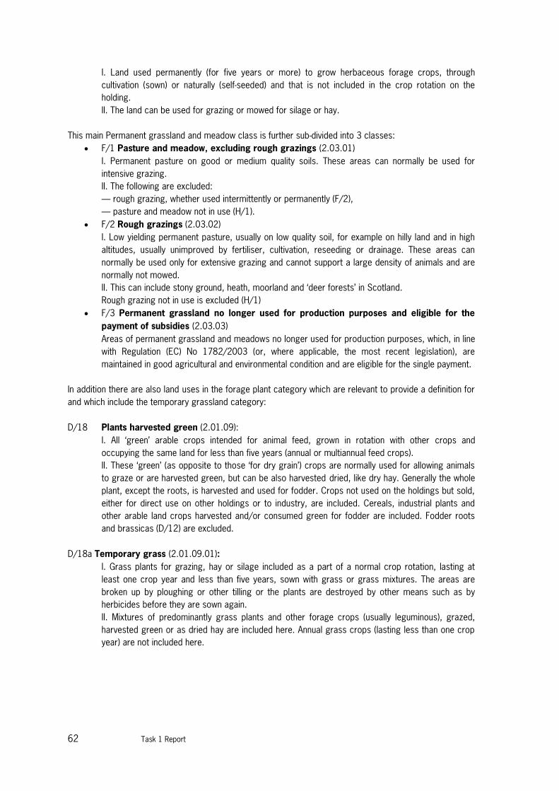
62 Task 1 Report
I. Land used permanently (for five years or more) to grow herbaceous forage crops, through
cultivation (sown) or naturally (self-seeded) and that is not included in the crop rotation on the
holding.
II. The land can be used for grazing or mowed for silage or hay.
This main Permanent grassland and meadow class is further sub-divided into 3 classes:
F/1 Pasture and meadow, excluding rough grazings (2.03.01)
I. Permanent pasture on good or medium quality soils. These areas can normally be used for
intensive grazing.
II. The following are excluded:
— rough grazing, whether used intermittently or permanently (F/2),
— pasture and meadow not in use (H/1).
F/2 Rough grazings (2.03.02)
I. Low yielding permanent pasture, usually on low quality soil, for example on hilly land and in high
altitudes, usually unimproved by fertiliser, cultivation, reseeding or drainage. These areas can
normally be used only for extensive grazing and cannot support a large density of animals and are
normally not mowed.
II. This can include stony ground, heath, moorland and ‘deer forests’ in Scotland.
Rough grazing not in use is excluded (H/1)
F/3 Permanent grassland no longer used for production purposes and eligible for the
payment of subsidies (2.03.03)
Areas of permanent grassland and meadows no longer used for production purposes, which, in line
with Regulation (EC) No 1782/2003 (or, where applicable, the most recent legislation), are
maintained in good agricultural and environmental condition and are eligible for the single payment.
In addition there are also land uses in the forage plant category which are relevant to provide a definition for
and which include the temporary grassland category:
D/18 Plants harvested green (2.01.09):
I. All ‘green’ arable crops intended for animal feed, grown in rotation with other crops and
occupying the same land for less than five years (annual or multiannual feed crops).
II. These ‘green’ (as opposite to those ‘for dry grain’) crops are normally used for allowing animals
to graze or are harvested green, but can be also harvested dried, like dry hay. Generally the whole
plant, except the roots, is harvested and used for fodder. Crops not used on the holdings but sold,
either for direct use on other holdings or to industry, are included. Cereals, industrial plants and
other arable land crops harvested and/or consumed green for fodder are included. Fodder roots
and brassicas (D/12) are excluded.
D/18a Temporary grass (2.01.09.01):
I. Grass plants for grazing, hay or silage included as a part of a normal crop rotation, lasting at
least one crop year and less than five years, sown with grass or grass mixtures. The areas are
broken up by ploughing or other tilling or the plants are destroyed by other means such as by
herbicides before they are sown again.
II. Mixtures of predominantly grass plants and other forage crops (usually leguminous), grazed,
harvested green or as dried hay are included here. Annual grass crops (lasting less than one crop
year) are not included here.

Task 1 report 63
4.1.4 FAOSTAT
In FAOSTAT under the land statistics (part of the Resource statistics), grassland categories are
distinguished. The main distinction is between temporal and permanent grassland and also irrigated versus
non-irrigated is distinguished and also the area under organic agriculture is indicated (Table 13). No further
information on the definitions and classification is provided at the FAO website.
Table 13. Definitions for grassland according to FAOSTAT land statistics
Item Code Item Name Definition
6656 Perm. meadows &
pastures - Cultivated
Permanent meadows and pastures is the land used permanently (five years
or more) to grow herbaceous forage crops, either cultivated or growing wild
(wild prairie or grazing land).
6659
Perm. meadows &
pastures - Nat.
grown
Permanent meadows and pastures - Naturally grown is the land not being
controlled under permanent meadows and pastures such as wild prairie or
grazing land.
6657
Perm. meadows &
pastures Cult. &
irrig
Permanent meadows and pastures - Cultivated and irrigated, area of the
"Cultivated Permanent meadows and pastures" which is actually irrigated in a
given year.
6658
Perm. meadows &
pastures Cult. non-
irrig
Permanent meadows and pastures - Cultivated and non- irrigated, area of the
"Cultivated Permanent meadows and pastures" which development relies on
rainfed irrigation in a given year.
6655
Permanent
meadows and
pastures
Permanent meadows and pastures is the land used permanently (five years
or more) to grow herbaceous forage crops, either cultivated or growing wild
(wild prairie or grazing land).
6682
Permanent
meadows and
pastures area
certified organic
Part of the area of the "Permanent meadows and pastures" exclusively
dedicated to organic agriculture and managed by applying organic
agriculture methods. It is the portion of land area managed (cultivated) or
wild harvested in accordance with specific organic standards or technical
regulations and that has been inspected and approved by a certification
body.
6683
Permanent
meadows and
pastures area in
conversion to
organic
Part of the area of the "Permanent meadows and pastures" which is going
through the organic conversion process, usually two years period of
conversion to organic land.
6681
Permanent
meadows and
pastures organic,
total
Sum of areas under “Permanent meadows and pastures area certified
organic” and "Permanent meadows and pastures area in conversion to
organic”.
6634 Temp. meadows &
pastures irrigated
Temporary meadows and pastures irrigated, area of the "Temporary
meadows and pastures" which is actually irrigated in a given year.
6635 Temp. meadows &
pastures non-irrig.
Temporary meadows and pastures non- irrigated, area of the "Temporary
meadows and pastures" which development relies on rainfed irrigation in a
given year.
6633
Temporary
meadows and
pastures
Temporary meadows and pastures is the land temporarily cultivated with
herbaceous forage crops for mowing or pasture. A period of less than five
years is used to differentiate between temporary and permanent meadows.

64 Task 1 Report
4.1.5 UNFCCC
The IPCC good practice guidance provide default definitions of grassland. However, every country can use
its own definition of grassland. According to the IPCC Good Practice Guidance for LULUCF (2003) the
definition of grassland is: “Grassland includes rangelands and pasture land that is not considered as
cropland. It also includes systems with vegetation that fall below the threshold used in the forest land
category and are not expected to exceed, without human intervention, the threshold used in the forest land
category. The category also includes all grassland from wild lands to recreational areas as well as
agricultural and silvi-pastural systems, subdivided into managed and unmanaged consistent with national
definitions”.
A very similar definition is used in the IPCC 2006 guidelines: “Grassland includes rangelands and pasture
land that are not considered Cropland. It also includes systems with woody vegetation and other non-grass
vegetation such as herbs and brushes that fall below the threshold values used in the Forest Land category.
The category also includes all grassland from wild lands to recreational areas as well as agricultural and silvi-
pastural systems, consistent with national definitions”.
However, countries are allowed to use their own definition for the different land use categories to account
for the local circumstances or to fit to available land use data sources. For example, in the Netherlands
orchards are included under grassland, since the soil under orchards is always covered by grass. Also
heatlands and peat moors are included under grasslands. Instead, in Spain the CORINE land cover map is
used as the basis for reporting under LULUCF, and they include the following categories under grassland:
231 (Pastures), 321 (Natural grassland), but also 242 (Complex cultivation patterns), 243 (Land principally
occupied by agriculture, with significant areas of natural vegetation) and 244 (Agro-forestry areas), see
Section 4.1.7. For these last categories a higher level breakdown of the CLC codes is used to discriminate
between grassland and cropland. This illustrates that there is now uniform approach at EU level to
distinguish grasslands.
4.1.6 LUCAS
The relevant classes for grassland of the LUCAS nomenclature are in stated below. The full nomenclature
can be found on the Eurostat website32.
Grassland (E00)
Land predominantly covered by communities of grassland, grass like plants and shrubs. The density of tree-
crown is less than 10% and the density of tree+shrub-crown is less than 20%. The following three
subclasses are discerned: E10 Grassland with sparse trees, E20 Grassland without trees, E30 Spontaneous
vegetation.
E10 Grassland with sparse trees: Land predominantly covered by communities of grassland, grass-like
plants and forbs including sparsely occurring trees (the density of the tree crown is between 5 and 10% and
the total density of the tree+shrub crown is between 5 and 20% of the area). Fruit trees in small groups or
along an avenue on grassland are classified here as well.
This class includes:
dry grasslands, dry edaphic meadows, steppes with gramineae and artemisia
32 http://epp.eurostat.ec.europa.eu/portal/page/portal/lucas/documents/Nomenclature_LUCAS2009_C_3.pdf

Task 1 report 65
plain and mountainous grassland
wet grasslands
alpine and subalpine grasslands
saline grasslands
arctic meadows
temporarily unstocked areas within forests
Links with Land Use
E10 - U111 Agriculture: Permanent pastures, rough grazings, alpages, meadows
E10 - U112 Fallow and abandoned land
E10 -
E10 - U31x Associated areas of transport areas
E10 - U340 Grassland attached to commerce, finance or business areas
E10 - U350 Grassland attached to community service areas
E10 - U36x Grassland for recreation: public gardens, golf courses and nature reserves
E10 - U370 Grassland attached to residential areas
E10 - U400 Natural grassland or grassland outside agricultural areas not utilized
E20 Grassland without trees: Land predominantly covered by communities of grassland, grass like plants
and forbs without trees and shrubland (density of tree+shrub crown is less than 5%).
This class includes:
dry grasslands, dry meadows and steppes
plain and mountainous grassland
wet grasslands
alpine and subalpine grasslands
saline grasslands
arctic meadows
temporarily unstocked areas within forests
Links with Land Use
E20 - U111 Agriculture: Permanent pastures, rough grazings, alpages, meadows
E20 - U112 Fallow and abandoned land
E20 - U120 Clear cuts within previously existing forests
E20 - U31x Associated areas of transport areas (e.g. aerodromes)
E20 - U340 Grassland attached to commerce, finance or business areas
E20 - U350 Grassland attached to community service areas
E20 - U36x Grassland for recreation: public gardens, golf courses, sports fields and nature
reserves
E20 - U370 Grassland attached to residential areas
E20 - U400 Natural grassland grassland outside agricultural not utilized
E30 Spontaneous vegetation: Mostly agricultural land which has not been cultivated this year or the years
before. It has not been prepared for sowing any crop this year. This class can also be found on unused land,
storage land etc.
Main case is agricultural land not providing a crop during the entire year or abandoned earlier agricultural
surfaces. It is occupied by spontaneous vegetation in case of set-aside arable land, with some tall herbs or
weeds. This class applies as well for former grassland or hedge margins which are currently not used
anymore but covered by tall herbs fringes. There might be some bare land pockets or crop residues and
spontaneous re-grown crops of the before management period. Only surfaces which have not been

66 Task 1 Report
deliberately sown and do not have any fodder crops like mixed cereals or are temporary grasslands classify
for this land cover class.
This class includes:
Set aside land within agricultural areas
Unused artificial land
This class excludes:
Other Legumes and mixtures for Fodder (B53)
Mixed cereals (B54)
Temporary grassland (B55)
Grassland without tree/shrub cover (E20)
Bare land (F00)
Links with Land Use
E30 - U112 Spontaneous vegetation on fallow and abandoned land
E30 - U120 Clear cuts within previously existing forests)
E30 - U140 Mining and quarrying if in use
E30 - U21x Energy and industrial production surfaces with spontaneous vegetation cover if still in
use
E30 - U31x Transport, storage, water and waste treatment etc surfaces with spontaneous
vegetation cover if in use
E30 - U400 Unused, spontaneously vegetated land
Class B50 is Fodder crops, this category includes Clovers (B51), Lucerne (B52), Other leguminous and
mixtures for fodder (B53), mix of cereals (B54) and temporary grassland (B55).
B55 Temporary grassland: Land occupied by temporary and artificial pastures, occupying the ground for
at least one crop year and less than five years, the seeds being either pure or mixed grass, on cropland
areas. This can also be the case on fallow fields, when i.e. after some years graminaceous plants settle over
spontaneously. If the soil is ploughed and /if the grass is sown the same year, the grassland is very likely a
temporary one and not a permanent one.
This class includes:
temporary pastures (Italian ryegrass, other ryegrasses, cock’s foot, fescues, timothy) on agricultural
areas/cropland
This class excludes:
permanent grassland (E)
Mix of legumes with gramineous plants for fodder (B53)
Mix of cereals for fodder (B54)
Links with Land Use
B55 - U111 Agricultural production
B55 - U113 Kitchen garden
B55 - U361 Amenities, museum, leisure
B55 - U364 Nature reserves

Task 1 report 67
4.1.7 CLC classification
The final CLC database consists of a geographical database describing land cover/use in 44 classes
grouped into a three level hierarchical structure (Table 14). The CORINE land cover nomenclature has 5
major categories at the first level, 15 land cover categories at the second level and 44 categories at the
third level. In Bossard et al. (2000) an extensive description is given for each CORINE land cover class,
including detailed descriptions with particularities, inclusions and exclusions, photo’s, and visual
interpretation characteristics. In Annex 1 examples for the different pasture types are provided.
Table 14. CORINE Land Cover nomenclature
LEVEL 1 LEVEL 2 LEVEL 3
1. ARTIFICIAL SURFACES 1.1. Urban fabric 1.2. Industrial, commercial and transport units 1.3. Mine, dump and construction sites 1.4. Artificial, non-agri-cultural vegetated areas
1.1.1. Continuous urban fabric 1.1.2. Discontinuous urban fabric 1.2.1. Industrial or commercial units 1.2.2. Road and rail networks and associated land 1.2.3. Port areas 1.2.4. Airports 1.3.1. Mineral extraction sites 1.3.2. Dump sites 1.3.3. Construction sites 1.4.1. Green urban areas 1.4.2. Sport and leisure facilities
2. AGRICULTURAL AREAS 2.1. Arable land 2.2. Permanent crops
2.3. Pastures
2.4. Heterogeneous agricultural areas
2.1.1. Non-irrigated arable land 2.1.2. Permanently irrigated land 2.1.3. Rice fields 2.2.1. Vineyards 2.2.2. Fruit trees and berry plantations 2.2.3. Olive groves
2.3.1. Pastures
2.4.1. Annual crops associated with permanent crops 2.4.2. Complex cultivation patterns 2.4.3. Land principally occupied by agriculture, with significant areas of natural vegetation 2.4.4. Agro-forestry areas
3. FOREST AND SEMI-NATURAL AREAS
3.1. Forests 3.2. Scrub and/or herbaceous associations 3.3. Open spaces with little or no vegetation
3.1.1. Broad-leaved forest 3.1.2. Coniferous forest 3.1.3. Mixed forest
3.2.1. Natural grassland
3.2.2. Moors and heathland 3.2.3. Sclerophyllous vegetation 3.2.4. Transitional woodland-scrub 3.3.1. Beaches, dunes, sands 3.3.2. Bare rocks 3.3.3. Sparsely vegetated areas 3.3.4. Burnt areas 3.3.5. Glaciers and perpetual snow
4. WETLANDS 4.1.Inland wetlands 4.2.Marine wetlands
4.1.1. Inland marshes 4.1.2. Peat bogs 4.2.1. Salt marshes 4.2.2. Salines 4.2.3. Intertidal flats
5. WATER BODIES 5.1. Inland waters 5.2. Marine waters
5.1.1. Water courses 5.1.2. Water bodies 5.2.1. Coastal lagoons 5.2.2. Estuaries 5.2.3. Sea and ocean
68 Task 1 Report
4.1.8 FAO-LCCS
The Land Cover Classification System (LCCS) is a comprehensive, standardized a priori classification
system, designed to meet specific user requirements, and created for mapping exercises, independent of
the scale or means used to map. The system can be used for any land cover classification initiative
anywhere in the world, using a set of independent diagnostic criteria that allow correlation with existing
classifications and legends. Land cover classes are defined by a combination of a set of independent
diagnostic criteria – the so-called classifiers – that are hierarchically arranged to assure a high degree of
geographical accuracy. Due to the heterogeneity of land cover, the same set of classifiers cannot be used
to define all land cover types. The hierarchical structure of the classifiers may differ from one land cover
type to another. Therefore, the classification has two main phases:
an initial Dichotomous Phase, where eight major land cover types are distinguished, and
a subsequent Modular-Hierarchical Phase, where the set of classifiers and their hierarchical
arrangement are tailored to the major land cover type.
Further definition of the Land Cover Class can be achieved by adding attributes. Two types of attributes,
which form separate levels in the classification, are distinguished:
Environmental Attributes are attributes (e.g. climate, landform, altitude, soil, lithology and erosion)
that influence land cover but are not inherent features of it, and which should not be mixed with
“pure” land cover classifiers, and
Specific Technical Attributes are associated with specific technical disciplines. Thus for
(Semi)Natural Vegetation, the Floristic Aspect can be added; for Cultivated Areas, the Crop Type;
and for Bare Soil, the Soil Type.
All Primarily Vegetated land cover classes are derived from a consistent physiognomic structural conceptual
approach that combines the classifiers Life Form, Cover and Height (in (Semi-)Natural Vegetation) and Life
Form (in Cultivated Areas) with Spatial Distribution. The Primarily Non-Vegetated classes have a similar
approach, using classifiers that deal with surface aspects, distribution or density, and height or depth.
The LCCS is a highly flexible a priori land cover classification in which each land cover class is clearly and
systematically defined, thus providing internal consistency. The system is truly hierarchical and applicable at
a variety of scales. Re-arrangement of the classes based on regrouping of the classifiers used facilitates
extensive use of the outputs by a wide variety of end-users. Accuracy assessment of the end product can be
generated by class or by the individual classifiers forming the class. All land covers can be accommodated
in this highly flexible system; the classification could therefore serve as a universally applicable reference
base for land cover, thus contributing towards data harmonization and standardization (Di Gregorio 2005, Di
Gregorio & Jansen 2005, Jansen 2010).
The LCCS first divides the landscape into areas that are primarily vegetated or non-vegetated. Each is then
divided further according to whether it is terrestrial or aquatic or regularly flooded. Within the vegetated
areas, areas that are cultivated or managed are separated from those that are semi-natural. Within the non-
vegetated category, artificial surfaces and associated areas (primarily urban) are separated from bare areas
and artificial and natural water bodies are distinguished.
Grasslands occur under “Cultivated and managed Terrestrial Areas” and “Natural and Semi-Natural
Terrestrial vegetation”. In the second modular-hierarchical phase a set of classifiers are tailored to the major
land cover types. Classifiers describing grassland are Life forms (Herbaceous – Forbs or Graminoids), Cover
and Height
Relevant definitions with regards to grasslands in the classification system are:

Task 1 report 69
Herbaceous: Plants without persistent stem or shoots above ground and lacking definite firm structure are
defined as herbaceous. There are two categories, depending on the physiognomy, namely Graminoids and
Forbs.
Graminoids: Includes all herbaceous grasses and other narrow-leaved grass-like plants that are not grasses
according to the taxonomic definition (Kuechler and Zonneveld, 1988). Guidelines: Graminoid vegetation is
defined by the presence of more than 75% of Graminoids in the herbaceous coverage. There is no upper
limit of height: the only condition is the physiognomy of the plant.
Cover: The cover can be considered as the proportion of a particular area of the ground, substrate or water
surface covered by a layer of plants, considered at the greatest horizontal perimeter level of each plant in
the layer. A distinction is made between closed (more than 60–70%), open (70–60% to 20–10%), closed to
open (between 100 and 15%) and sparse (20–10% to 1%). As herbaceous plants are seasonal in character,
it has to be noted that the cover of herbaceous vegetation is always considered at the time of its fullest
development.
Height: The height of a certain layer is measured from the ground to the average top of the Life Form being
assessed (Kuechler and Zonneveld, 1988). The fact that single plants of one synusia differ from the average
height can be ignored, apart from the fact that they can form their own layer (e.g. the emergents of a
rainforest that tower above the rest). Height sub-divisions are: >30 down to 3 m for Trees; 5 m to 0.3 m for
Shrubs; and 3 m to 0.03 m for Herbaceous. Each class is further sub-divided.
4.1.9 EAGLE
The EAGLE group (EIONET Action Group on Land monitoring in Europe) was set up as a working group with
members of EIONET NRCs on land cover. The group evolved as a response to the growing need to discuss
solutions for a better integration of national mapping activities with European land monitoring initiatives (i.e.
CORINE Land Cover) at technical level and independent from any political or industry preferences following
the concept of a bottom-up approach.
The objective of the working group is to elaborate a future-oriented conceptual solution that will allow the
“feeding” of a European land monitoring database from existing national sources, and to integrate the
upcoming approach of object oriented data modelling in the field of land monitoring. The discussion
embarked on how to describe the earth’s surface in a conceptual way and how to store that descriptive
information on land cover and land use in a data model. The main deliverables of the EAGLE working group
are: i) EAGLE matrix: A tool for semantic comparison between the class definitions of different classification
systems by decomposing them to land cover components, land use attributes and further landscape
characteristics and ii) EAGLE data model: A UML model representation of the conceptual data model,
visualized in the form of a graphical UML chart.
Although the work of the EAGLE group is still on-going, an example of the classification for grasslands is
provided below:
1. Herbaceous Plants (Grasses and Forbs)
Annual, biennial or perennial plants that do not have a persistent woody stem above the ground (in botanical
term: herb). In contrary to woody plants, which have stems above ground that remain alive during the
dormant season and grow shoots the next year from the above-ground parts, shoots of herbaceous plant
die down at the end of growing season, so they regenerate themselves from tissues left above or under the
ground (e.g. bulbs, rhizomes, tubers, seeds).

70 Task 1 Report
1.1.1. Graminaceous (grass-like)
Grasses, or more technically graminoids, are monocotyledonous, usually herbaceous plants with narrow
leaves growing from the base. They include the "true grasses", of the Poaceae (or Gramineae) family, as well
as the sedges (Cyperaceae) and the rushes (Juncaceae). The true grasses include cereals, bamboo and the
grasses of lawns (turf) and grassland. Sedges include many wild marsh and grassland plants, and some
cultivated ones. Belonging here regardless of being wild-growing - forming natural grasslands or being
component of other biomes (e.g. wetlands, forest, tundra) or cultivated – forming cropland (arable, meadow,
pasture) or grass surfaces / lawn for sports / recreation.
1.1.1.1. Regular Graminaceous (grasses, cereals)
Annual or perennial graminaceous plants, naturally growing or cultivated, with potential height not exceeding
2 meter. This includes most grass species and cereals (e.g. wheat, barley, maize, rice), except reeds and
bamboo.
4.1.10 DG Environment project Ecologically Valuable Grasslands
In a related project for DG Environment (Contract No. 07-0307/2012/633993/ETU/B1), which is currently
executed by Alterra, data and definitions on ecologically valuable grasslands are analysed. The purpose of
this study is to provide a synthesis of data available, and consider the need for improved data, on certain
specific environmental issues (including ecologically valuable grasslands) linked to agriculture, so as to
underpin the policy process in these areas. One of the guiding developments in this respect are new policies
currently under discussion in the new CAP. These new policy developments are an important context for this
study and will be discussed in the next chapter of this report.
This study also proposes several relevant definitions for grasslands (see Elbersen et al., in press).
Grassland is defined as all land which is in agricultural use and is not permanent crops or arable and thus:
1) Excludes grasslands in which there is no evidence of human intervention (e.g. through grazing,
mowing) and cannot therefore be categorized as agricultural land.
2) Includes all uncultivated land with vegetation that is grazed and/or cut for fodder, including
herbaceous and non-herbaceous species.
Ecologically Valuable Grassland (EVG) are a category of grasslands (including those with non-herbaceous
species) that are notable, within the overall context of agricultural grasslands, for their ecological value. EVG
have a spectrum of values depending on management but focus on biodiversity value and there is often a
strong relation between high biodiversity value and other services. The EVG are semi-natural and natural
grasslands that are not agriculturally-improved (e.g. through cultivation, reseeding, fertilisation, irrigation
and drainage) of long standing and species–rich (taking account of all taxa not only higher plants).

Task 1 report 71
4.2 Habitat classifications
There are many regional and national habitat classifications which will not be considered (Mucher et al.,
2004). Knowledge of these other European habitat classifications is an advantage in the process of
European habitat mapping. Unfortunately, these classifications differ in nomenclature, criteria and approach
which makes it not always easy to relate and compare them. Dengler et al. (2013) introduce a series of
articles devoted to the classification of European grasslands that will appear as a Virtual Special Feature in
the journal of Applied Vegetation Science. They want to (1) initiate the preparation and publication of
international classifications for European grasslands and (2) stimulate the necessary methodological
developments for producing such studies.
In Figure 14 an overview is given of the most important European habitat classifications (classification in
terms of typology and nomenclature). The EUNIS habitat classification has been developed under the
guidance of the European Environmental Agency (EEA) and will probably become the new standard, however
this classification is still in progress. The EUNIS habitat classification is based upon experience from
amongst others the Palaearctic habitat classification (Devilliers & Deviliers-Terschuren, 1996) and the
CORINE biotopes classification (CEC, 1991). CORINE biotopes and the Palaearctic classification are strongly
related. The EUNIS habitat classifications has made formal links to the other classifications and made them
available at the website (http://eunis.eea.europa.eu/habitats.jsp).
Figure 14. Relationships between various existing habitat classifications and related databases
(figure is little outdated)
The major European habitat classifications will be discussed in more detail in the following paragraphs,
concerning the following classifications: Annex I habitats of the EU Habitats Directive, the EUNIS habitat
classification and the phytosociological alliances as well as the nomenclatures of the following databases:
CORINE Biotopes, CORINE land cover and the PNV map. All these classifications are theoretical and have not
been tested in the field. Experience has shown that training and standardised field recording procedures are
essential to produce reliable figures and clear definitions.
4.2.1 Habitats Directive
The European Commission has published an Interpretation Manual of EU habitats in 1999 for the delineation
of Natura 2000 sites (European Commission, 2007). It states: “The EU Habitats Directive is a Community
10 (1), 58 (2), 2279 (3)
EUNIS Habitat Classification
EU Habitats Annex I Habitats Directive
Biotopes Corine
European
Vegetation Survey Phytosociological alliances
Land CoverCorine
Palaearctic Habitat Classification
BioHab General
Habitat Classification
9 F, 80 C, 233 O, 928 A
9 (1), 33 (2),198 (3), 65 P.
90 (1) 5 (1), 15 (2), 44 (3)
Emerald Bern Convention
Res, No. 4 Habitats
7 (1), 44 (2)
PNVPot. Natural Vegetation
19 F, 60 (2), >= 700 (3)

72 Task 1 Report
legislative instrument in the field of nature conservation that establishes a common framework for the
conservation of wild animal and plant species and natural habitats of Community importance; it provides for
the creation of a network of special areas of conservation, called Natura 2000, to maintain and restore, at
favourable conservation status, natural habitats and species of wild fauna and flora of Community interest”.
Animal and plant species names are clearly presented in the Directive and, despite minor misspellings or use
of synonyms. In contrast, the development of a common agreed definition is essential for the different
habitat types of Annex I.
Figure 15. Distribution of Natura 2000 sites across EU-25 (Source: EEA, 2010)
Annex I lists today 231 European natural habitat types, including 71 priority (i.e. habitat types in danger of
disappearance and whose natural range mainly falls within the territory of the European Union). Annex I is
based on the hierarchical classification of European habitats developed by the CORINE Biotopes project 2
since that was the only existing classification at European level. The habitat types for natural and semi-
natural grassland formations are stated in
Task 1 report 73
Table 15.
Soon a report will be published by the European Commission on guidance on how to integrate Natura 2000
conservation objectives into farming practices. This report also provides a table (called Annex A) that
describes the key Annex I habitat types that are dependent on agriculture and the degree of dependency for
each, as well as their distribution, total extent, proportion of habitat within Natura 2000 designated sites,
and current conservation status.

74 Task 1 Report
Table 15. Habitat types for natural and semi-natural grassland formations
61. Natural grasslands
6110 * Rupicolous calcareous or basophilic grasslands of the Alysso-Sedion albi
6120 * Xeric sand calcareous grasslands
6130 Calaminarian grasslands of the Violetalia calaminariae
6140 Siliceous Pyrenean Festuca eskia grasslands
6150 Siliceous alpine and boreal grasslands
6160 Oro-Iberian Festuca indigesta grasslands
6170 Alpine and subalpine calcareous grasslands
6180 Macaronesian mesophile grasslands
6190 Rupicolous pannonic grasslands
62. Semi-natural dry grasslands and scrubland facies
6210 Semi-natural dry grasslands and scrubland facies on calcareous substrates (Festuco-
Brometalia) (* important orchid sites)
6220 * Pseudo-steppe with grasses and annuals of the Thero-Brachypodietea
6230 * Species-rich Nardus grasslands, on silicious substrates in mountain areas (and submountain
areas in Continental Europe)
6240 * Sub-Pannonic steppic grasslands
6250 * Pannonic loess steppic grasslands
6260 * Pannonic sand steppes
6270 * Fennoscandian lowland species-rich dry to mesic grasslands
6280 * Nordic alvar and precambrian calcareous flatrocks
62A0 Eastern sub-mediteranean dry grasslands (Scorzoneratalia villosae)
62B0 * Serpentinophilous grasslands of Cyprus
62C0 *Ponto-Sarmatic steppes
62D0 Oro-Moesian acidophilous grasslands
63. Sclerophillous grazed forests (dehesas)
6310 Dehesas with evergreen Quercus spp.
64. Semi-natural tall-herb humid meadows
6410 Molinia meadows on calcareous, peaty or clayey-silt-laden soils (Molinion caeruleae)
6420 Mediterranean tall humid grasslands of the Molinio-Holoschoenion
6430 Hydrophilous tall herb fringe communities of plains and of the montane to alpine levels
6440 Alluvial meadows of river valleys of the Cnidion dubii
6450 Northern boreal alluvial meadows
6460 *Peat grasslands of Troodos
65. Mesophile grasslands
6510 Lowland hay meadows (Alopecurus pratensis, Sanguisorba officinalis)
6520 Mountain hay meadows
6530 * Fennoscandian wooded meadows
The description of Annex I habitats was provided by national experts. Each habitat is described in terms of:
1. Natura 2000 code: a four digit code
2. Explicit name of the habitat
3. Definition. This is a general description in terms in terms of vegetation, syntaxa, abiotic features
and origin.

Task 1 report 75
4. Characteristic species. Listing of animal and plant key species including details of their occurrence
on Annexes II and IV
5. Geographic distribution
6. Correspondence with other classification systems
7. Bibliographic references.
An example of a full description of an Annex I habitat type is given in the box below.
4.2.2 EUNIS Habitat classification
The EUNIS habitat classification is strongly related to the Palaearctic habitat classification but a novel feature
of the hierarchical classification is the development of clear criteria in order to make a key for the
identification of habitats analogous to keys for identification of species. These criteria are however not
appropriate for field mapping because many terms used e.g. fry and montane do not have definitions that
can be used in the field. The classification is based on general vegetation science with additions of abiotic
features. The EUNIS habitat classification gives a more comprehensive overview of European habitats (more
than 2600 terrestrial classes have been identified already) than the 231 Annex I habitats of the Habitats
Directive and has a more scientific approach.
For the purposes of EUNIS, a ‘habitat’ is defined as: ‘a place where plants or animals normally live,
characterized primarily by its physical features (topography, plant or animal physiognomy, soil
characteristics, climate, water quality etc.) and secondarily by the species of plants and animals that live
there’ (Davies and Moss, 2002). On their website it is stated (http://eunis.eea.europa.eu/habitats.jsp) that:
“the EUNIS Habitat classification has been developed to facilitate harmonised description and collection of
data across Europe through the use of criteria for habitat identification. It is a comprehensive pan-European
system, covering all types of habitats from natural to artificial, from terrestrial to freshwater and marine
habitats types. It is built to link to and correspond with other major habitat systems in Europe”. It cross-
references to all EU Habitats Directive habitat types used for EU Member States. The EUNIS classification
has four formal levels. Units at level 5, 6 and 7 have been added only to complete the linkage to the marine
classification or to Annex I of the Habitats Directive.
6120 * Xeric sand calcareous grasslands PAL.CLASS.: 34.12
1) Dry, frequently open grasslands on more or less calciferous sand with a subcontinental centre of
distribution (Koelerion glaucae, Sileno conicae-Cerastion semidecandri, Sedo-Cerastion p.).
2) Plants: Allium schoenoprasum, Alyssum montanum ssp. gemelinii, Astragalus arenarius, Cardaminopsis
arenosa, Carex ligerica, Carex praecox, Dianthus deltoides, Euphorbia seguieriana, Festuca psammophila,
Gypsophila fastigiata, Helichrysum arenarium, Herniaria glabra, Koelerion glauca, Petrorhagia prolifera,
Sedum reflexum, Silene chlorantha.
3) Corresponding categories
German classification : "340403 ausdauernder Sandtrockenrasen mit geschlossener Narbe". Nordic
classification: "5141 Koeleria glauca-typ".
4) This habitat type occurs in association with non coastal dune complexes.
5) Olsson, H. (1974). Studies on South Swedish sand vegetation. Acta Phytogeogr. Suec. 60:1-170.

76 Task 1 Report
Table 16. EUNIS major habitats (first level)
A Marine habitat
B Coastal habitats
C Inland surface water habitats
D Mire, bog and fen habitats
E Grassland and tall forb habitats
F Heathland, scrub and tundra habitats
G Woodland and forest habitats and other wooded land
H Inland unvegetated or sparsely vegetated habitats
I Regularly or recently cultivated agricultural, horticultural and domestic habitats
J Constructed, industrial and other artificial habitats
On the first level the EUNIS habitat classification has ten major habitats (Table 16). On the second level there
are 54 habitats, on the third level there are 162 habitats and on the lowest level there are already more than
2400 habitats for the terrestrial environment.
Table 17. Second level EUNIS habitats related to grassland (Source: Hill et al., 2004)
EUNIS
code
Level EUNIS name Description
E 1 Grasslands and
lands
dominated by
forbs, mosses
or lichens
Non-coastal land which is dry or only seasonally wet (with the water table at
or above ground level for less than half of the year) with greater than 30%
vegetation cover. The vegetation is dominated by grasses and other non-
woody plants, including mosses, macrolichens, ferns, sedges and herbs.
Includes semiarid steppes with scattered [Artemisia] scrub. Includes
successional weedy vegetation and managed grasslands such as recreation
fields and lawns. Excludes regularly tilled habitats (I1) dominated by
cultivated herbaceous vegetation such as arable fields.
E1 2 Dry grasslands Well-drained or dry lands dominated by grass or herbs, mostly not fertilized
and with low productivity. Included are [Artemisia] steppes. Excluded are dry
mediterranean lands with shrubs of other genera where the shrub cover
exceeds 10%; these are listed as garrigue (F6).
E2 2 Mesic
grasslands
Lowland and montane mesotrophic and eutrophic pastures and hay
meadows of the boreal, nemoral, warm-temperate humid and mediterranean
zones. They are generally more fertile than dry grasslands (E1), and include
sports fields and agriculturally improved and reseeded pastures.
E3 2 Seasonally wet
and wet
grasslands
Unimproved or lightly improved wet meadows and tall herb communities of
the boreal, nemoral, warm-temperate humid, steppic and mediterranean
zones.
E4 2 Alpine and
subalpine
grasslands
Primary and secondary grass- or sedge- dominated formations of the alpine
and subalpine levels of boreal, nemoral, mediterranean, warm-temperate
humid and Anatolian mountains.
E5 2 Woodland
fringes and
clearings and
tall forb stands
Stands of tall herbs or ferns, occuring on disused urban or agricultural land,
by watercourses, at the edge of woods, or invading pastures. Stands of
shorter herbs forming a distinct zone (seam) at the edge of woods.
E6 2 Inland salt
steppes
Saline land with dominant salt-tolerant grasses and herbs. Excludes saline
scrubland, listed under F6.8 xero-halophile scrubs.
E7 2 Sparsely
wooded
grasslands
Grasslands with a wooded overstorey that normally has less than 10%
cover.

Task 1 report 77
Figure 16. Example of EUNIS Habitat classification for dry grasslands to level 3
4.2.3 Phytosociological plant communities in Europe
Phytosociology is the science which attempts to describe the diversity of plant communities. An overview of
the European phytosociological plant communities at the level of alliances is given in Rodwell et al. (2002). In
an attempt to develop a more coherent picture of the vegetation across the whole of Europe, the European
Vegetation Survey (EVS), a working group of the international association of vegetation science was
established in 1992. Besides providing formal support for national programmes of vegetation survey, the
EVS has devoted particular meetings to the understanding of the syntaxonomy and ecology of the major
vegetation groups across Europe as defined by Rodwell et al. (2002).
On the first level there are 15 formations on the second level there are 80 classes, on the third level there
are 233 orders and on the fourth level there are 928 alliances. In Annex 2 all phytosociological alliances for
grasslands are provided. A link with the EUNIS habitat classification has been described for most
phytosociological alliances. However, most alliances have several EUNIS classes (and vice versa) indicating
that the links are not straightforward in many cases.
A link needs to be established also with Annex I habitat types. A linkage with the phytosociological
communities in Europe of the most important habitat classifications will significantly improve the description
of those habitat types, not only in terms of their species composition but also in terms of their abiotic
requirements.

78 Task 1 Report
4.3 Assessment of grassland definitions and classifications
In this Chapter we will make a first assessment of grassland definitions and classifications and their
usefulness for EU policies. Grassland related data are relevant to several EU policies, including the Nitrates
Directive, Common Agricultural Policy (CAP), climate policy, biodiversity policies and the Renewable Energy
Directive (RED). Below we shortly describe these policies and the relevance of grassland data for these
policies.
4.3.1 Policy-related data needs related to grasslands
Nitrates Directive
The main objectives of the Nitrates Directive are to reduce water pollution caused or induced by nitrates
from agriculture, and to prevent further such pollution. Member states have to take actions in so-called
nitrate vulnerable zones (NVZ), which have to be presented in an Action Programme. The area and
production of grasslands is required for several aspects in the Nitrates Directive. For all crops, member
states have to present nitrogen application standards (and in some member states also phosphorus
application standards), which follow the principle of balanced nitrogen (or phosphorus) application. The yield
and nitrogen uptake of the crops are important factors affecting the application standards.
Countries can apply for a derogation for application of manure above the standard of 170 kg N per year
following the Nitrates Directive. One of the criteria of using more manure than this standard is the nitrogen
uptake capacity and the length of growing season. Grasslands have a long growing-season and high nitrogen
uptake capacity. This shows that there is a clear need by the Nitrates Directive for data on grassland area
and production (for different grassland types and management).
Common Agricultural Policy
The Common Agricultural Policy (CAP) is the European Union legislation regulating agriculture and rural
development. The 2003 reform of CAP introduced a major change in European agricultural policy and
‘decoupled,’ the direct link between farm payments and agricultural production. For the post-2013 CAP the
EC proposed "greening measures” to further support innovation in and sustainability of farming by linking
them to the system of direct payments (pillar one). Three measures have been proposed i.e. crop
diversification, permanent grassland protection and ecological focus areas. The strength in these measures
lies in the fact that they create a level playing field in the Union, because they are compulsory for almost all
farmers. The greening measures go beyond cross-compliance obligations and raise the baseline, thereby
increasing the environmental ambitions of the EU as a whole.
The 2003 CAP reform obliges Member States to ensure that their area of permanent pasture (the ratio
compared to total agricultural land) does not reduce as a result of the reform. The monitoring is based on a
ratio of permanent pasture compared to total agricultural land. If there is a significant decrease in the ratio,
national authorities may impose measures to stop the decline (e.g. prior authorisation for ploughing;
obligation to return arable land to pasture). Good information on the grassland and especially the status of
permanency is obviously very important for correct payment of the CAP subsidies. In addition, there are
some aspects under cross compliance related to grasslands, including the Nitrates Directive and Habitat
Directive and some of the measures under the good agricultural and environmental condition (GAEC).
EU climate policy
Grasslands are an important stock of carbon and a source of nitrous oxide. Countries have to report the
emissions to the United Nations Framework Convention on Climate Change (UNFCCC). Different
methodologies are used to quantify greenhouse gas emissions. Emissions of N2O are different for
grasslands than for cropland, and some countries like the Netherlands use different emission factors for

Task 1 report 79
grassland than for arable land (Velthof and Mosquera, 2011). For such an approach, the area and
management of grassland is needed. As IPCC encourage countries to use country specific Tier 2 or 3
methodologies it may be expected that the need for data on area and use of grasslands will increase.
In addition the EU parliament recently approved a law to establish common rules for accounting for GHG
emissions and removals of carbon from the atmosphere resulting from activities related to land use, land-
use change and forestry (LULUCF). This decision represents a first step towards incorporating the forestry
and agriculture sectors, the last major sectors without common EU-wide rules on GHG, into EU climate
policy. One of the aspects is the mandatory accounting of grazing land management by the member states,
for which more grassland related data would be needed. This includes data on soil type (especially grassland
on peat soil), changes in land use, and information of grassland management (e.g. grazing and grassland
renewal).
Biodiversity policies
The EU is committed to the protection of biodiversity, and to halting biodiversity loss within the EU by 2020.
The EU has built up a network of 26000 protected areas in all the Member States and an area of more than
750.000 km2, which is known as Natura 2000. The legal basis for Natura 2000 comes from the Birds
Directive and the Habitats Directive, which form the backbone of the EU's internal biodiversity policy. The
Habitats Directive (92/43/EEC) has focused on the requirement of Member States to establish a network of
special areas of conservation (SACs) that, together with the special protection areas (SPAs) designated
under the Birds Directive (79/409/EEC), make up the Natura 2000 network. The Habitats Directive requires
continuous monitoring of the condition of species and habitats within each member state, with results being
updated every six years. The Birds Directive (2009/147/EC) is aimed at the conservation of wild birds,
which creates a comprehensive scheme of protection for all wild bird species naturally occurring in the
European Union.
The EU biodiversity strategy to 2020 (COM(2011) 244) has defined six targets, of which Target 3 is to
increase the contribution of agriculture and forestry to maintaining and enhancing biodiversity. It aims to
maximise by 2020 the areas under agriculture across grasslands, arable land and permanent crops that are
covered by biodiversity-related measures under the CAP so as to ensure the conservation of biodiversity.
The strategy should bring a measurable improvement in the conservation status of species and habitats that
depend on or are affected by agriculture and in the provision of ecosystem services as compared to the EU
2010 Baseline. The improvement is to be measured against the quantified enhancement targets for the
conservation status of species and habitats of EU interest and the restoration of degraded ecosystems.
Renewable Energy Directive
In 2009 the Renewable Energy Directive (2009/28/EC) on the promotion of the use of energy from
renewable sources was adopted. The Directive sets ambitious targets for all Member States, such that the
EU will reach a 20 % share of energy from renewable sources by 2020 and a 10 % share of renewable
energy specifically in the transport sector. It also establishes a sustainability scheme for biofuels and
bioliquids: in order to be accounted in the national binding targets biofuels and bioliquids have to meet
specified sustainability criteria set in article 17 of the Directive. One of the criteria is that no raw material
should be obtained from land with high biodiversity value, which includes highly biodiverse grassland.
Highly biodiverse grassland is defined as i) natural, namely grassland that would remain grassland in the
absence of human intervention and which maintains the natural species composition and ecological
characteristics and processes; or ii) non-natural, namely grassland that would cease to be grassland in the
absence of human intervention and which is species-rich and not degraded, unless evidence is provided that
the harvesting of the raw material is necessary to preserve its grassland status. This definition has been the
source of debate among experts, policy makers and environmental NGOs with uncertainty over its coverage
and how the definitions could be operationalised. The European Commission is tasked with establishing

80 Task 1 Report
‘criteria and geographic ranges to determine which grassland shall be covered (Bowyer, 2010). However,
these have currently not yet been published by the Commission. Although the RED refers to the global level,
also data on European grasslands is required to identify these areas of highly biodiverse grasslands.
In Table 18 we have identified the different data needs on grassland for the respective EU policies. The data
needs included are grassland area, grassland yield, biodiversity value, permanency, status of grazing, status
of fertilization, status of tillage, status of cutting, area of non-grasslands which are grazed and amount of
manure from grazing on non-grasslands. For example, for the Nitrates Directive information on nutrient
balances is very important, to calculate these data on grassland area, yield and fertilization (including
mineral fertilizer, grazing and applied manure) is needed. For the Renewable Energy Directive the data need
focusses on the identification of high biodiverse grasslands, which are not allowed to be converted to other
land uses for bioenergy production. In this case the area and biodiversity value are most important.
Table 18. Data needs on grassland for different EU policies
Data needs Nitrates
Directive
Common
Agricultural
Policy
EU Climate
policies
Biodiversity
policies
Renewable
Energy Directive
Grassland area X X X X
Grassland yield X (X)
Biodiversity value X X X
Permanency (X) X X X (X)
Status of grazing (X) (X)
Status of fertilization X X X
Status of tillage X X
Status of cutting (X) (X) (X)
Area non-grasslands
which are grazed
X (X)
Amount of manure
from grazing on non-
grasslands
X
4.3.2 Assessment of existing grassland definitions and classifications for EU policies
For this assessment we included the grassland definitions and classifications as described in Chapter 4.1
and 4.2 with a few exceptions. The work of the European Grassland Federation, the DG Environment project
on ecologically valuable grasslands and by the EAGLE working group is still on-going and no final definition or
classification has yet been established. Therefore these three sources of grassland definitions and
classifications have not been included in the assessment, but will be taken into account in Task 3. Also the
EUNIS Habitat classification and the phytosociological plant communities in Europe are not further discussed
here, since the focus of this project is mainly on grassland for agricultural uses and their production
potential, while the very detailed habitat classifications have a very strong focus on biodiversity aspects.
International terminology for grazing lands and grazing animals
The benefit of the international terminology for grazing lands and grazing animals is that it is accepted by the
global grassland research community. However, in several cases the definitions are not sufficiently
elaborated to be used directly for policy purposes. For example in the definition of permanent and temporary
grassland no time horizon is included in the definition for a clear distinction between these two categories.
Furthermore, there is no data source behind these definitions, which would only make them useful for new
grassland data inventories.

Task 1 report 81
Common Agricultural Policy
The current definition of permanent grassland under the CAP is more clear compared to the one from the
international terminology, since the temporal dimension is specified. However, the definition still leaves
space for discussion, which is also shown by different interpretations of the definition by the EU member
states, see Beaufoy et al. (2011). Moreover, the definition for the post 2013 CAP is still under discussion,
and is probably broader compared to the current definition.
Farm Structure Survey
The grassland definitions from the farm structure survey are useful for agricultural purposes. It has a clear
distinction between permanent and temporary grassland and also the rough grazing grasslands are
distinguished. However, it does not address the biodiversity aspects of grassland, and also the intensity of
grassland use is not very well expressed in these definitions. However, the benefit of this classification is
that it is widely used in the data collection on grasslands for Eurostat (e.g. FSS, FADN and partly for the
crop statistics).
FAOSTAT
The FAOSTAT classification for grasslands is rather extensive and distinguishes between permanent and
temporary grassland. It also provides information regarding the intensity of use, i.e. whether it is cultivated
or naturally grown and whether it is irrigated or under organic agriculture. However, the availability of data
for the sub-categories is very limited in FAOSTAT (see Table 5).
UNFCCC
The general definition of grassland as stated in the IPCC good practice guidance for LULUCF (2003) is very
broad and is a kind of remaining category, in which other land uses that are not cropland, forestland,
wetland or settlement. In addition, many countries use their own definition of grassland for UNFCCC
reporting. This definition is too broad and not consistent among member states for most EU policy
purposes.
LUCAS
The LUCAS land use classification is well elaborated and includes a good split between temporary and
permanent grassland. However, the subclasses of grassland (Grassland with sparse trees, Grassland
without trees, and Spontaneous vegetation) are linked to land cover than land use and do not provide further
detail about management, which is relevant for EU policies. The benefit of the LUCAS land use data is that
these are collected in a harmonized way throughout the EU and it is actually observed data in the field.
CLC classification
The CLC classification has been developed for land cover data. The classification is well elaborated and
frequently used in remote sensing studies. However, the classification does not provide much information
about the grassland management. Pastures refer to permanent grassland (> 5 years not in rotation), but the
temporary grasslands are not included as separate category. On the other hand natural grasslands are
better distinguished compared to many agricultural related classifications.
FAO-LCCS
The Land Cover Classification System (LCCS) is mainly aimed at land cover related classifications, which
means that land management is not included as criteria in the classification. Grasslands can be described in
terms of life form, cover and height, which can be relevant for biodiversity purposes, but not directly for
agricultural and environmental policies. The classification is often used in a global context, due to the
involvement of FAO, but it is not frequently used in Europe.

82 Task 1 Report
Habitats Directive
The habitat classification of the Habitats Directive (Annex 1) provides a good classification for the natural
and semi-natural grasslands in Europe. It distinguishes about 30 grassland habitats, which are reasonably
well described. However, it is only focussed on the semi-natural and natural grasslands and does not include
the more intensively used agricultural grasslands. In addition harmonisation and further improvement of the
habitat definitions and descriptions is still continuing (see e.g. EC, 2013), which
In Table 19 we assessed the usefulness of the current grassland definitions and classifications for the
different policy needs of the Nitrates Directive, EU Climate policies, Common Agricultural Policy, Habitat
Directive and the Renewable Energy Directive. The table shows that there is indeed the need for better data
on the issue of defining, classifying, collecting and disseminating data on European grassland areas, use
and production.
For the Nitrates Directive none of the current grassland classifications and definitions really fits the policy
needs, as there is no clear distinction in the intensity and management level of the grasslands. The same
holds for the climate policies, for which also data on grassland management would be needed. For the CAP
the definition of permanent grassland and the FSS statistics are currently sufficient, but with the renewal of
the CAP probably new data needs on grassland will be added (e.g. grasslands within Natura 2000 areas).
For biodiversity policies the corresponding classification is useful, however, the mapping of the habitats at
EU level still requires harmonisation, and there is not yet an overall EU map with all habitats according to this
classification. Finally for the Renewable Energy Directive a definition and corresponding mapping of highly
biodiverse grassland is needed, but none of the current definitions would fit, or all grassland classified under
the habitat Directive should be included.
Table 19. Assessment of usefulness of grassland classifications and definitions for different EU policies
(white is high, grey medium and black low potential for use policy data needs)
Classification /
definition
Nitrates
Directive
Common
Agricultural
Policy
EU
Climate
policies
Biodiversity
policies
Renewable
Energy
Directive
International terminology
for grazing lands and
grazing animals
Common Agricultural
Policy
Farm Structure Survey
FAOSTAT
UNFCCC
LUCAS
CLC classification
FAO-LCCS
Habitats Directive

Task 1 report 83
5 Conclusion and recommendations
Based on the presented sources of grassland information (Chapter 3) and the review of current definitions
and classifications of grassland (Chapter 4) we come to the following conclusions and recommendations:
Spatial coverage for most grassland sources is sufficient and cover the EU-27. Spatial resolution differs
largely, many statistical sources only provide data at national level, whereas the remote sensing
sources can provide data at 100 meter grid cell resolution.
The current remote sensing sources for data on grassland areas, do not provide data on productivity.
Other remote sensing sources might be used to derive productivity data, however, most of them are
still in experimental stage or have high uncertainty, see Task 2 report.
Most statistical sources have already established a long time series and provide data at annual time
steps. The remote sensing sources are often products produced for a certain year, although for the
Corine Land Cover maps several time steps are available and updates are on-going.
Few sources have clear and harmonized grassland definitions. The statistical sources of FADN, FSS and
FAOSTAT do have clear definitions for different grassland types, although it remains unclear whether
member states provide all information according to these definitions. Although remote sensing sources
have clear classification schemes, the usefulness is limited as the classification is focussed on land
cover and not on land use (e.g. no distinction between permanent and temporary grassland).
Many EU policies require data on grasslands. Harmonization of grassland definitions and classifications
would reduce the amount of data that has to be collected and would improve the data quality. None of
the current grassland definitions and classifications does achieve the data needs of the different EU
policies.

84 Task 1 Report

Task 1 report 85
6 References
Allen, V.G., Batello, C., Berretta, E.J., Hodgson, J., Kothmann, M., Li, X., McIvor, J., Milne, J., Morris, C.,
Peeters, A., Sanderson, M., The, F., Grazing Terminology, C., 2011. An international terminology
for grazing lands and grazing animals. Grass and Forage Science, 66: 2-28.
Beaufoy, G., Jones G., Kazakova, Y., McGurn, P., Poux, X., Stefanova, V. 2011. Permanent Pastures and
Meadows under the CAP: the situation in 6 countries. European Forum on Nature Conservation and
Pastoralism (EFNCP).
Bossard, M., Feranec, J. and Otahel, J. 2000. CORINE Land Cover Technical Guide – Addendum 2000. EEA
Technical Report No 40. EEA, Copenhagen.
Bowyer, C. 2010. Interpreting grassland requirements set out within the Directive on Renewable Energy
(Directive 2009/28/EC). Institute for European Environmental Policy, London.
Büttner, G., Kosztra, B., Maucha, G. and Pataki, R. 2012. Implementation and achievements of CLC2006.
Institute of Geodesy, Cartography and Remote Sensing (FÖMI), Finland.
Collins, S. and Beaufoy, G. 2012. Improving the targeting, monitoring and management of semi-natural
grasslands across Europe – essential steps to achieving EU Biodiversity Strategy targets on
farmland. European Forum for Nature Conservation and Pastoralism (EFNCP) and Butterfly
Conservation Europe and (EFNCP).
Davies, C.E. and Moss, D., 2002. EUNIS habitat classification. Final report to the European topic centre of
nature protection and biodiversity, European Environment Agency, Copenhagen.
Dengler, J., Bergmeier, E., Willner, W., Chytrý, M. 2013. Towards a consistent classification of European
grasslands. Applied Vegetation Science: 16, 518-520.
Devos W. and Pavel, M. 2010. LPIS applications and quality - Report of the Land Parcel Identification System
(LPIS) annual workshop Copenhagen (Denmark), 20-22nd September 2010. JRC62599. Joint
Research Centre of the European Commission, Ispra, Italy.
Di Gregorio, A. 2005. Land Cover Classification System Classification concepts and user manual Software
version (2). Food and Agriculture Organization of the United Nations, Rome.
http://www.fao.org/docrep/008/y7220e/y7220e00.htm
Di Gregorio and Jansen. 2005. Land Cover Classification System. Classification concepts and user manual.
FAO, Rome.
Elbersen, B.S., et al. In press. Aspects of data on diverse relationships between agriculture and the
environment. Second interim report. Contract No. 07-0307/2012/633993/ETU/B1. Alterra,
Wageningen.
European Commission, 2007. Interpretation Manual of European Union habitats – EUR27. European
Commission.

86 Task 1 Report
European Commission, 2013. Farming for Natura 2000. Guidance on how to integrate Natura 2000
conservation objectives into farming practices, based on Member States good practice
experiences (FINAL DRAFT). Brussels.
Eurostat. 2012. Economy-wide Material Flow Accounts (EW-MFA). Compilation guide 2012.
Feranec, J., Soukup, T., Hazeu, G., Jaffrain, G. , 2012. Land cover and its change in Europe: 1990-2006. In
Giri, P. Ch. (Ed.). Remote sensing of land use and land cover: principles and applications. Boca
Raton (CRC Press), pp. 285-301.
King, M. 2010. An investigation into policies affecting Europe’s semi-natural grasslands. Report to EFNCP.
The Grasslands Trust, Eastleigh, UK.
Lesschen, J.P., van den Berg, M., Westhoek, H.J., Witzke, H.P., Oenema, O., 2011. Greenhouse gas
emission profiles of European livestock sectors. Animal Feed Science and Technology 166–167,
16-28.
Olea, L. and San Miguel-Ayanz, A. 2006. The Spanish dehesa. A traditional Mediterranean silvopastoral
system linking production and nature conservation. Opening Paper 21st General Meeting of the
European Grassland Federation. Badajoz, Spain.
Paracchini, M.L., Petersen, J.E., Hoogeveen, Y., Bamps, C., Burgield, I., van Swaay, C. 2008. High Nature
Value Farmland in Europe. An estimate of the distribution patterns on the basis of land cover and
biodiversity data. EUR 23480. JRC, Ispra, Italy.
Reheul D., De Vliegher A., Bommelé L. and Carlier L. 2007. The comparison between temporary and
permanent grassland. Grassland Science in Europe, 12: 1-13.
Rodwell, J. S., Pignatti, S., Mucina, L., Schaminée, J. H.J, 1995. European vegetation survey: update on
progress. J. Veg. Sci. 6 (5), 759-762.
Rodwell, J.S., Schaminée, J.H.J., Mucina, L., Pignati, S., Dring, J., Moss, D., 2002. The Diversity of
European Vegetation. An overview of phytosociological alliances and their relationships to EUNIS
habitats. EC-LNV Report nr. 2002/054. Wageningen, The Netherlands, 168 pp.
Smit, H.J., Metzger, M.J., Ewert, F., 2008. Spatial distribution of grassland productivity and land use in
Europe. Agricultural Systems, 98: 208-219.
Velthof, G.L and Mosquera, J. 2011. Calculation of nitrous oxide emission from agriculture in the
Netherlands: update of emission factors and leaching fraction. Alterra report 2151. Alterra,
Wageningen, The Netherlands.
Westhoek, H. et al. 2011. The Protein Puzzle: The consumption and production of meat, dairy and fish in the
European Union. PBL Netherlands Environmental Assessment Agency, The Hague.
White, R.P., Murray, S., Rohweder, M. 2000. Pilot analysis of global ecosystems; Grassland ecosystems.
World Resources Institute, Washington, DC.

Task 1 report 87
Annex 1 CLC Pastures definition
Class 2.3 Pastures
Lands, which are permanently used (at least 5 years) for fodder production. Includes natural or sown
herbaceous species, unimproved or lightly improved meadows and grazed or mechanically harvested
meadows. Regular agriculture impact influences the natural development of natural herbaceous species
composition.
Dense grass cover, of floral composition, dominated by graminacea, not under a rotation system. Mainly for
grazing, but the fodder may be harvested mechanically. Includes areas with hedges (bocage).
Extension:
Grazing used by cattle. Pastures can be described as extensively used grasslands with presence of farm
structure such as: fences, shelters, enclosures, watering places, drinking trough, or regular agricultural
works: mowing, drainage, hay making, agricultural practices, manuring.
This class includes:
- temporary and artificial pastures not under a rotation system which become permanent
grasslands five years after ploughing. Significant number of natural vegetation species are
present (as Taraxacum officinale, Ranunculus spp., Chrisanthemum leucantemum, Knautia
arvensis, Achillea millefolium, Salvia spp., etc.);
- abandoned arable land not under a rotation system used as pastures (after 3 years);
- humid meadows with dominating grass cover. Sedges, rushes, thistles, nettles, cover less than
25 % of the parcel surface;
- pastures with scattered trees and shrubs.
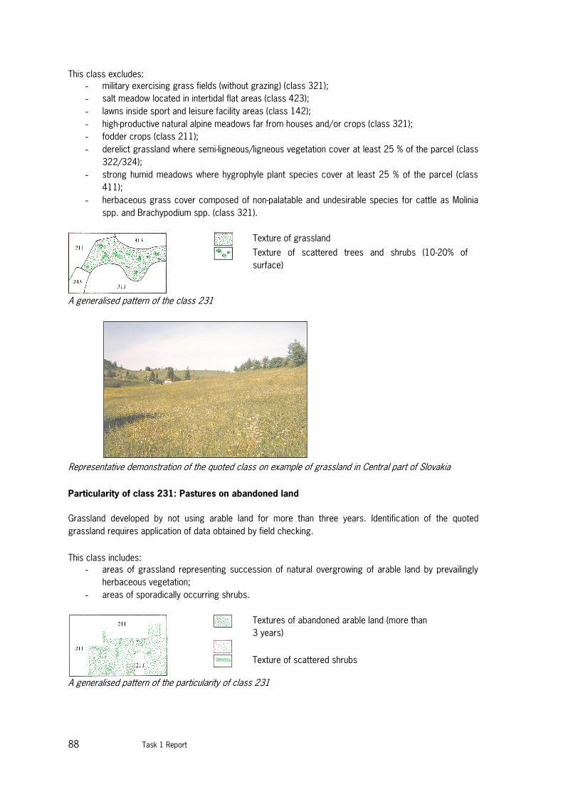
88 Task 1 Report
This class excludes:
- military exercising grass fields (without grazing) (class 321);
- salt meadow located in intertidal flat areas (class 423);
- lawns inside sport and leisure facility areas (class 142);
- high-productive natural alpine meadows far from houses and/or crops (class 321);
- fodder crops (class 211);
- derelict grassland where semi-ligneous/ligneous vegetation cover at least 25 % of the parcel (class
322/324);
- strong humid meadows where hygrophyle plant species cover at least 25 % of the parcel (class
411);
- herbaceous grass cover composed of non-palatable and undesirable species for cattle as Molinia
spp. and Brachypodium spp. (class 321).
Texture of grassland
Texture of scattered trees and shrubs (10-20% of
surface)
A generalised pattern of the class 231
Representative demonstration of the quoted class on example of grassland in Central part of Slovakia
Particularity of class 231: Pastures on abandoned land
Grassland developed by not using arable land for more than three years. Identification of the quoted
grassland requires application of data obtained by field checking.
This class includes:
- areas of grassland representing succession of natural overgrowing of arable land by prevailingly
herbaceous vegetation;
- areas of sporadically occurring shrubs.
Textures of abandoned arable land (more than
3 years)
Texture of scattered shrubs
A generalised pattern of the particularity of class 231

Task 1 report 89
Representative of the quoted class particularity on example of pasture on abandoned land in Latvia
Particularity of class 231: Wooded meadows
Meadows where dispersed trees and shrubs occupy up to 50% of surface of the area. These meadows are
characterised by rich floristic composition.
This class includes:
- areas of grassland, partially covered by tree crowns;
- areas of scattered trees and shrubs.
Texture of grassland
Texture of scattered trees and shrubs (40-50% of surface)
A generalised pattern of the particularity of class 231
Representative of the quoted class particularity on example of wooded meadow in Virtsu-Laelatu (Estonia)
321 Natural grassland
Low productivity grassland. Often situated in areas of rough, uneven ground. Frequently includes rocky
areas, briars and heathland.

90 Task 1 Report
Extension:
Natural grasslands are areas with herbaceous vegetation (maximum height is 150 cm and gramineous
species are prevailing) which cover at least 50 % of the surface covered by vegetation which developed
under a minimum human interference (not mowed, fertilized or stimulated by chemicals which might
influence production of biomass); here belong for instance grass formations of protected areas, karstic
areas, military training fields, etc. (even though the human interference cannot be altogether discarded in
quoted areas, it does not suppress the natural development or species composition of the meadows), areas
of shrub formations of scattered trees.
This class includes:
- saline grasslands grown on temporary wet areas of saline soils;
- humid meadows where sedges, rushes, thistles, nettles cover more than 25 % of the parcel;
- natural grasslands with trees and shrubs if they do not cover more than 25 % of the surface to be
considered;
- high-productive Alpine grasslands far from houses, crops and farming activities;
- herbaceous military training areas;
- grasslands which can be grazed, never sown and not otherwise managed by way of application of
fertilizers, pesticides, drainage or reseeding except by burning;
- grasslands with a yearly productivity less than 1.500 units of fodder/ha;
- herbaceous grass covered composed of non-palatable gramineous species such as
Molinia spp.and Brachypodium spp.;
- derelict natural grassland where ligneous vegetation cover less than 75 % of the area;
- grasslands found on calcareous soils with a high proportion of calcicole species of limestone, chalk
Machair or Karst;
- grasslands dotted with bare rock areas which represent less than 25 % of the surface.
This class excludes:
- grey dunes (class 331);
- swampy grassland (class 411);
- fallow land (class 211).
Texture of natural grassland
Texture of scattered trees and shrubs
A generalised pattern of the class 321
Representative demonstration of the quoted class of natural grassland in the Morava floodplain (Slovakia)
Generalisation:
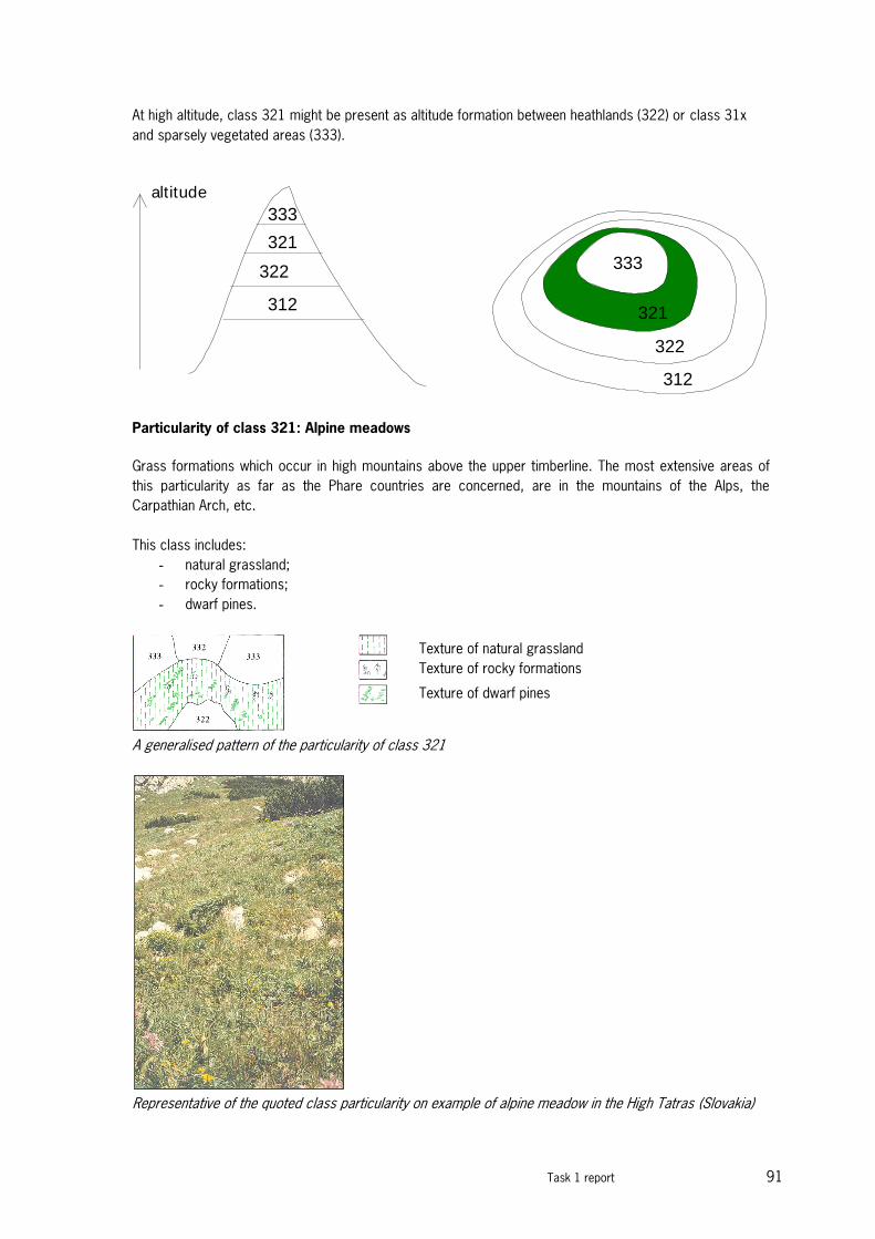
Task 1 report 91
At high altitude, class 321 might be present as altitude formation between heathlands (322) or class 31x
and sparsely vegetated areas (333).
333
322
321
312
312
322
321
333
altitude
Particularity of class 321: Alpine meadows
Grass formations which occur in high mountains above the upper timberline. The most extensive areas of
this particularity as far as the Phare countries are concerned, are in the mountains of the Alps, the
Carpathian Arch, etc.
This class includes:
- natural grassland;
- rocky formations;
- dwarf pines.
Texture of natural grassland
Texture of rocky formations
Texture of dwarf pines
A generalised pattern of the particularity of class 321
Representative of the quoted class particularity on example of alpine meadow in the High Tatras (Slovakia)

92 Task 1 Report
Particularity of class 321: Grass formations of inundated alluvial plains and coastal plains,
lowlands
Human influence is very low with regard to natural conditions – of grass formations - extreme soil humidity
and seasonal inundated.
This class includes:
- natural grassland;
- water bodies;
- shrub formations and scattered trees.
Texture of natural grassland
Texture of water surfaces
Texture of scattered trees and shrubs
A generalised pattern of the particularity of class 321
Representative of the quoted class particularity on examples of lower coastal grassland and upper coastal
grassland (Rumpo and Vaemla, Estonia)
Task 1 report 93
Annex 2 Phytosociological alliances for
grasslands
G TEMPERATE GRASSLANDS, HEATHS AND FRINGE VEGETATION
26 MOLINIO-ARRHENATHERETEA
Anthropogenic pastures and meadows on deeper, more or less fertile soils in lowland regions 26A ALTHAEETALIA OFFICINALIS
Meadows in the steppe and semi-desert zones of east Europe on moderately saline flooded
soils
26A01 Althaeion officinalis
Meadows of the Lower Volga valley and surrounding limans on moderately saline flooded
soils
26A02 Euphorbion palustris
Meadows in the steppe part of the Ural river valley on moderately saline flooded soils
26B ARRHENATHERETALIA
Pastures and meadows on well-drained relatively fertile mineral soils 26B01 Arrhenatherion
Meadows of well-drained, relatively fertile mineral soils at lower altitudes E2.1
Permanent mesotrophic pastures and aftermath-grazed meadows E2.2 Coarse
permanent grassland and tall herbs, usually mown but little grazed
E3.4 Moist or wet eutrophic and mesotrophic grassland
26B02 Cynosurion cristati
Pastures of relatively well-drained, fertile mineral soils at lower altitudes in central and
western Europe
E2.1 Permanent mesotrophic pastures and aftermath-grazed meadows E2.2
Coarse permanent grassland and tall herbs, usually mown but little grazed
E2. 6 Agriculturally-improved, re-seeded and heavily fertilized grassland, including sports
fields and grass lawns
E3.4 Moist or wet eutrophic and mesotrophic grassland
26B03 Gaudinio fragilis-Cynosurion cristati
Thermo-atlantic and supramediterranean mesic meadows of France and Spain
E2.2 Coarse permanent grassland and tall herbs, usually mown but little grazed 26B04 Pancicion serbicae
Thermophilous montane meadows of the central Balkans
26B05 Phyteumo-Trisetion
Meadows of less fertile mineral soils in central Europe with influence of Atlantic
climate
E2.2 Coarse permanent grassland and tall herbs, usually mown but little grazed
E2.3 Mountain hay meadows 26C CIRSIETALIA VALLIS-DEMONIS
Montane meadows in Sicily and Calabria
26C01 Plantaginion cupanii
Montane mesic meadows in Sicily and Calabria
E2.2 Coarse permanent grassland and tall herbs, usually mown but little grazed
26D GALIETALIA VERI
Dry steppic herb-rich meadows of Ukraine and southern Russia
26D01 Artemision ponticae

94 Task 1 Report
Steppe meadows of the lower reaches of the Don river floodplain
E2.5 Meadows of the steppe zone
26D02 Polygonion krascheninnikovii
Meadows of tall herbs on fertile mineral soils of the forest and montane zones of the
South Ural
E2.5 Meadows of the steppe zone 26D03
Seselion libanotis
Steppe meadows of the lower reaches of Ural river floodplain
E2.5 Meadows of the steppe zone 26D04
Trifolion montani
Dry meadows of forest-steppe and steppe in east Europe and Siberia
E2.5 Meadows of the steppe zone 26E HOLOSCHOENETALIA
Humid meadows and reed communities in the Mediterranean region 26E01
Dactylorhizo-Juncion striati
Calabro-Sicilian humid meadows of high altitudes
E1.4 Mediterranean tall-grass and [Artemisia] steppes 26E02
Deschampsion mediae
Humid pastures on loamy soils
E3.2 Mediterranean short humid grassland
26E03 Gaudinio fragilis-Hordeion bulbosi
Humid meadows on sandy soils along the Mediterranean coast 26E04
Molinio-Holoschoenion
Reed communities on humid and seasonally sub-saline soils on ancient dune systems
C3.3 Water-fringing beds of tall canes
C3.4 Species-poor beds of low-growing water-fringing or amphibious vegetation
D5.2 Beds of large sedges normally without free-standing water E3.1
Mediterranean tall humid grassland
26E05 Sieglingion decumbentis
Wet meadows on edges of mountain water courses in Corsica 26F MOLINIETALIA
Meadowsand pastures of moister soils, often peaty
26F01 Alopecurion pratensis
Meadows of fresh nutrient-rich soils dominated by graminoids, in floodplains of large
rivers in central and eastern Europe
E2.1 Permanent mesotrophic pastures and aftermath-grazed meadows E2.2
Coarse permanent grassland and tall herbs, usually mown but little grazed E3.3 Sub-mediterranean humid meadows
E3.4 Moist or wet eutrophic and mesotrophic grassland 26F02
Calthion palustris
Wet meadows and pastures of fertile, often manured soils of western and central
Europe
D5.2 Beds of large sedges normally without free-standing water
E2.1 Permanent mesotrophic pastures and aftermath-grazed meadows E3.4
Moist or wet eutrophic and mesotrophic grassland
E5.5 Subalpine moist or wet tall-herb and fern habitats 26F03 Carici distichae-Oenanthion fistulosae
Submediterranean-atlantic wet meadows of broad valleys of western Europe 26F04
Cnidion venosi
Floodplain alluvial meadows of sub-continental regions of central Europe E3.4 Moist
or wet eutrophic and mesotrophic grassland
26F05 Deschampsion cespitosae

Task 1 report 95
Oligohaline moist tussocky meadows of southeast Europe E3.4 Moist
or wet eutrophic and mesotrophic grassland 26F06 Fiipendulion
Tall-herb vegetation, seldom mown or grazed, on moist fertile mineral soils and peats
D5.2 Beds of large sedges normally without free-standing water E3.4 Moist
or wet eutrophic and mesotrophic grassland
E5.4 Moist or wet tall-herb and fern fringes and meadows E5.5
Subalpine moist or wet tall-herb and fern habitats 26F07 Juncion acutiflori
Meadows and pastures of moist peaty mineral soils with flushing or impeded drainage
E3.4 Moist or wet eutrophic and mesotrophic grassland E3.5 Moist
or wet oligotrophic grassland 26F08 Junco-Molinion
Meadows of moist but fresh soils in western Europe, usually unmanured E3.5 Moist
or wet oligotrophic grassland
26F09 Lythro-Euphorbion
Meadows of moist soils in the river valleys of the semi-desert zone of European
Russia
E3.4 Moist or wet eutrophic and mesotrophic grassland E5.4 Moist
or wet tall-herb and fern fringes and meadows 26F 10 Molinion
caeruleae
Wet unmanured low-altitude meadows of central Europe E3.4 Moist or
wet eutrophic and mesotrophic grassland E3.5 Moist or wet
oligotrophic grassland
26F1 1 Trifolion squamosi
Slightly saline inundated herb-rich meadows of hind-dune habitats A2. 6
Coastal saltmarshes and saline reedbeds
26F 12 Veronico longifoliae-Lysimachion vulgaris
Central European sub-continental unmown tall-forb meadows on alluvia of large rivers
E5.4 Moist or wet tall-herb and fern fringes and meadows 26G PASPALO-HELEOCHLOETALIA
Periodically flooded grasslands of muddy alluvia in the Mediterranean region 26G01
Paspalo-Agrostidion semiverticillati
Grassy carpets on muddy soils in the western Mediterranean region
E1.4 Mediterranean tall-grass and [Artemisia] steppes
E5.4 Moist or wet tall-herb and fern fringes and meadows 26G02
Trifolio fragiferi-Cynodontion
Slightly saline flooded disturbed grasslands of the Mediterranean region 26H PLANTAGINI-PRUNELLETALIA
Weedy grasslands on trampled soils of shaded habitats
26H01 Plantagini-Prunellion
Weedy grasslands on trampled soils of shaded habitats
E3.4 Moist or wet eutrophic and mesotrophic grassland 26I POO ALPINAE-TRISETETALIA
High-altitude mesic hay meadows of the Alps
26I01 Poion alpinae
Cattle pastures of heavy fertile soils in subalpine belt of the Alps and Carpathians
E2.1 Permanent mesotrophic pastures and aftermath-grazed meadows E4.5
Alpine and subalpine enriched grassland
26I02 Poion supinae
Grasslands of heavily-trampled and overgrazed pastures at higher altitudes in temperate
mountains of Europe
26I03 Triseto-Polygonion bistortae

96 Task 1 Report
Meadows of well-drained, relatively fertile mineral soils in low-input agricultural
systems of montane regions
E2.2 Coarse permanent grassland and tall herbs, usually mown but little grazed
E2.3 Mountain hay meadows
E4.5 Alpine and subalpine enriched grassland 26J POTENTILLO-POLYGONETALIA
Temporarily flooded disturbed grasslands of temperate Europe
26J01 Alopecurion utriculati
Oligohaline mediterranean-subatlantic meadows of western Europe 26J02 Potentillion anserinae
Low herb communities of variable habitats with wet-dry, or brackish-fresh conditions
B1.4 Coastal stable dune grassland (grey dunes)
B1.8 Moist and wet dune slacks
C1.6 Temporary lakes, ponds and pools (wet phase)
D6. 1 Inland saltmarshes
E2.1 Permanent mesotrophic pastures and aftermath-grazed meadows
E2. 6 Agriculturally-improved, re-seeded and heavily fertilized grassland, including sports
fields and grass lawns
E3.4 Moist or wet eutrophic and mesotrophic grassland
E6.2 Continental inland saline grass and herb-dominated habitats
H5.3 Clay, silt, sand and gravel habitats with very sparse or no
vegetation 26K TRIFOLIO-HORDEETALIA
Amphiadriatic meadows of endorhoeic basins (polj es) and similar periodicallyflooded habitats
26K01 Molinio-Hordeion secalini
Dalmatian riverine and floodplain damp meadows E3.3 Sub-
mediterranean humid meadows 26K02 Ranunculion velutini
Apennine damp meadows of karstic plains E3.3 Sub-
mediterranean humid meadows 26K03 Trifolion pallidi
Riverine and damp meadows of the northern Dinarides E3.3 Sub-
mediterranean humid meadows
26K04 Trifolion resupinati
Oligohaline flooded meadows in central and southern Balkans and northern Greece
E3.3 Sub-mediterranean humid meadows
27 STIPO GIGANTEAE-AGROSTIETEA CASTELLANAE
Mediterranean-Iberoatlantic meso- to supra-mediterranean perennial grasslands
27A AGROSTIETALIA CASTELLANAE
Iberian perennial pastures of meso- and supra-mediterranean belts
27A01 Agrostio castellanae-Stipion giganteae
Pastures on humic brown soils in the mediterranean zone of Iberia
E1.A Mediterranean dry acid and neutral open grassland
27A02 Agrostion castellanae
Iberian meso- to supra-mediterranean perennial grasslands
E2.4 Iberian summer pastures (vallicares)
27A03 Festucion elegantis
Pastures on humic brown soils in humid Mediterranean mountains in Iberia E1.8
Mediterranean dry acid and neutral closed grassland
27B FESTUCETALIA JUBATAE
Supra-mediterranean open grasslands of the Azores and Madeira 27B01
Deschampsio maderensis-Parafestucion albidae
Supra-mediterranean open grasslands of Madeira
28 FESTUCO-BROMETEA
Task 1 report 97
Steppes, rocky steppes and sandy grasslands of the sub-continental temperate and subboreal
regions 28A ASTRAGALO-POTENTILLETALIA
Dry steppic grasslands of the submontane and montane belt of the south-central Balkans
28A01 Armerio-Potentillion
Dry steppic grasslands over siliceous bedrock in the montane belt of Macedonia
28A02 Koelerio-Festucion dalmaticae
Dry steppic grasslands over dolomite and ultramafic rock in Serbia 28A03
Saturejo-Thymion
Dry steppic grasslands over ultramafic rocks of Macedonia and south Serbia 28B BRACHYPODIETALIA PHOENICOIDIS
West and central Mediterranean dry perennial meadows and abandoned fields 28B01
Brachypodion phoenicoidis
West and central Mediterranean dry perennial meadows and abandoned fields E1.2
Perennial calcareous grassland and basic steppes
E5. 1 Over-grazed arid Mediterranean garrigues (ermes) 28C BROMETALIA ERECTI
Meso-xerophilous grasslands on deep calcareous soils 28C01 Artemisio albae-Dichanthion ischaemi
Meso-xerophilous, calcareous grasslands 28C02 Bromion erecti
Meso-xerophytic swards in sub-oceanic regions of western Europe B1.4
Coastal stable dune grassland (grey dunes)
E1.2 Perennial calcareous grassland and basic steppes
28C03 Cirsio-Brachypodion pinnati
Meso-xerophytic swards in sub-continental regions of central and eastern Europe
E1.2 Perennial calcareous grassland and basic steppes 28C04
Cytiso-Bromion caprini
Submediterranean subarid grasslands of mid-altitudes in Calabria F7.4
Hedgehog-heaths
28C05 Danthonio-Brachypodion
Meso-xerophilous grasslands of the southern and eastern Carpathians E1.2
Perennial calcareous grassland and basic steppes 28C06 Festuco-Bromion
Meso-xerophytic swards of submediterranean regions of Provence and the Ligurian Alps
28C07 Gentianello amarellae-Avenulion pratensis
Meso-xerophytic swards of north-west Europe
28C08 Phleo ambigui-Bromion erecti
Meso-xerophytic submontane-montane swards of the northern and central Apennines
E1.5 Mediterraneo-montane grassland
28C09 Potentillo montanae-Brachypodion rupestris
Steppic grasslands of northern Spain and the Pyrenees
E1.2 Perennial calcareous grassland and basic steppes 28C10
Teucrio pyrenaici-Bromion erecti
Calcareous chamaephyte-rich dry pastures in the Cantabrian area F7.4
Hedgehog-heaths 28D BROMOPSIETALIA CAPPADOCICAE
Steppes and dwarf semi-shrubby communities of Crimean mountains 28D01
Adonido vernalis-Stipion tirsae
Crimean steppes and dwarf-shrub communities of low altitudes 28D02
Carici humilis-Androsacion tauricae
Crimean steppes and dwarf-shrub communities of higher altitudes 28D03
Veronico multifidae-Stipion ponticae

98 Task 1 Report
Communities of foothills in the eastern part of south Crimean coast and northern
Crimean mountains 28E FESTUCETALIA VAGINATAE
European Continental steppes and dry meadows on sandy soils 28E01
Bromion tectorum
Pioneer vegetation among Pannonian steppe grasslands on acid sands E1.2
Perennial calcareous grassland and basic steppes
E1.9 Dry, open perennial and annual siliceous grassland, including inland dune
grassland
28E02 Cynodonto-Teucrion polii
Communities of older quartz sands and shell detritus on dunes with primitive soils in the
Azov region
E1.2 Perennial calcareous grassland and basic steppes 28E03
Festucion beckeri
Communities of Ukrainian sandy steppes
B1.4 Coastal stable dune grassland (grey dunes)
E1.2 Perennial calcareous grassland and basic steppes E3.4 Moist
or wet eutrophic and mesotrophic grassland 28E04 Festucion
vaginatae
Communities of Pannonian sandy steppes
E1.2 Perennial calcareous grassland and basic steppes
E1.9 Dry, open perennial and annual siliceous grassland, including inland dune
grassland
E3.4 Moist or wet eutrophic and mesotrophic grassland 28E05
Scabiosion ucranicae
Sand steppes of plains around the western seaboard of the Black Sea
B1.4 Coastal stable dune grassland (grey dunes)
E1.2 Perennial calcareous grassland and basic steppes
28E06 Verbascion pinnatifidii
Communities of young quartz sands and shell detritus behind avadunes in the Azov region
B1.3 Shifting coastal dunes
E1.2 Perennial calcareous grassland and basic steppes 28F FESTUCETALIA VALESIACAE
Sub-continental to continental closed fescue pastures and swards 28F01
Agropyrion pectinati
Xerophilous steppes on slightly saline soils described from the middle Volga region
E1.2 Perennial calcareous grassland and basic steppes 28F02
Artemisio tauricae-Festucion
Xerothermic communities on volcanic substrates in the Crimea 28F03
Danthonio-Stipion tirsae
Circum-Pannonian steppic grasslands on deep soils with fluctuating yearly moisture
regime
E1.2 Perennial calcareous grassland and basic steppes 28F04
Diplachnion
Periodically arid swards on clayey soils in continental valleys of the eastern Alps
E1.2 Perennial calcareous grassland and basic steppes 28F05
Festucion valesiacae
Sub-continental closed fescue pastures and swards of central Europe
E1.2 Perennial calcareous grassland and basic steppes
E1.9 Dry, open perennial and annual siliceous grassland, including inland dune
grassland 28F06 Helianthemo-Globularion

Task 1 report 99
Sub-boreal and boreal steppes of rendzinas on hard limestone (alvars)
E1.1 Open thermophile pioneer vegetation of sandy or detritic ground E1.2
Perennial calcareous grassland and basic steppes
28F07 Stipion lessingianae
Steppes of deep soils in Moldova, Dobrudga and southern Ukraine E1.2
Perennial calcareous grassland and basic steppes 28F08 Stipo-Poion
carniolicae
Very arid swards of continental valleys in the western Alps E1.2
Perennial calcareous grassland and basic steppes 28F09 Stipo-Poion
xerophilae
Very arid swards of continental valleys in the central and eastern Alps E1.2
Perennial calcareous grassland and basic steppes
28F 10 Thymo comosi-Festucion sulcatae
Steppic dry grasslands of Transsylvania 28G HALACSYETALIA SENDTNERI
Steppic vegetation on ultramafic soils in the Balkans
28G01 Centaureo-Bromion fibrosi
Rocky steppic grasslands over ultramafic bedrocks in Serbia and Albania 28G02
Polygonion albanicae
Rocky steppic grasslands over ultramafic bedrocks in central Bosnia 28G03
Potentillion visianii
Rocky steppic grasslands over ultramafic bedrocks in eastern Bosnia 28H HELICTOTRICHO-STIPETALIA
Continental temperate grasslands of the steppe and semi-desert zones of the south Urals
region and northern Kazakhstan
28H01 Centaurion sumensis
Xerophilous steppe communities of stony substrates in the Middle Volga region
E1.2 Perennial calcareous grassland and basic steppes 28H02
Helictotricho desertori-Stipion rubentis
Continental steppes of North Kazakhstan and the South Ural
E1.2 Perennial calcareous grassland and basic steppes 28H03
Lathyro pallescentis-Helictotrichion schelliani
Xero-mesophilous steppes in the South Ural region 28H04
Orostachyion spinosae
Floristically impoverished dry steppe communities of stony substrates
E1.2 Perennial calcareous grassland and basic steppes 28H05
Scorzonero austriacae-Koelerion sclerophyllae
Xerophilous steppes of calcareous soils in the South Ural region
E1.2 Perennial calcareous grassland and basic steppes 28H06
Tanaceto-Stipion lessingianae
Steppes of west Kazakhstan and adjacent parts of Russia
28I KOELERIO-PHLEETALIA PHLEOIDIS
Silicicolous rocky steppic grasslands of western and central Europe 28I01
Chrysopogono-Danthonion
Steppic swards of lime-poor sandy soils in Serbia
E1.2 Perennial calcareous grassland and basic steppes 28I02
Koelerio-Phleion phleoidis
Steppic rocky grasslands and swards of lime-poor sandy soils in central and Western
Europe
E1.2 Perennial calcareous grassland and basic steppes
E1.9 Dry, open perennial and annual siliceous grassland, including inland dune
grassland
100 Task 1 Report
F4.2 Dry heaths 28J POO-AGROSTIETALIA VINEALIS
Mesoxerophilous acidophilous alluvial sandy grasslands of Ukraine 28J01
Agrostio-Avenulion schellianae
Steppic acidophilous swards in eastern Europe
28J02 Agrostion vinealis
Xero-mesophilous meadows on leached chernozem-like soils E2.5
Meadows of the steppe zone 28K SCORZONERO-CHRYSOPOGONETALIA
Calcareous karstic grasslands of the Illyric-Dinaric region 28K01
Centaureion dichroanthae
Illyrian-Praealpic steppic pastures on shallow calcareous soils 28K02
Chrysopogoni-Saturejon
Illyrian-Dinaric steppic pastures on shallow calcareous soils
E1.2 Perennial calcareous grassland and basic steppes F2.2
Evergreen alpine and subalpine heath and scrub
28K03 Chrysopogono-Koelerion splendentis
I llyrian-Dinaric open steppic grasslands on calcareous substrates 28K04 Scorzonerion villosae
Illyrian-Dinaric dry pastures on deep, partly decalcified terra rossa and argillaceous
flysch sediments of the Illyric and Dinaric regions
28L SESLERIETALIA RIGIDAE
Dealpine, closed, blue-grass dominated grasslands of the Alps, Hercynicum and Carpathians 28L01 Diantho lumnitzeri-Seslerion albicantis
Dealpine grasslands on limestone and dolomite in south-east central Europe E1.1 Open
thermophile pioneer vegetation of sandy or detritic ground E1.2 Perennial
calcareous grassland and basic steppes
28L02 Seslerio-Xerobromion
Dealpine calcareous grasslands of the northern fringes of the Alps and of Hercynicum
E1.2 Perennial calcareous grassland and basic steppes 28L03
Seslerion rigidae
East Carpathian dealpine closed calcareous grasslands
E1.2 Perennial calcareous grassland and basic steppes
E4.4 Calciphilous alpine and subalpine grassland 28M STIPO PULCHERRIMAE-FESTUCETALIA PALLENTIS
Open xerophilous rocky grasslands of sunny aspects of central and southeast Europe 28M01
Alyssion bertolonii
Steppic vegetation on ultramafic soils in the northern Apennines and Tuscany E1.2
Perennial calcareous grassland and basic steppes
28M02 Alysso saxatilis-Festucion pallentis
Open grasslands on mineral-rich siliceous rocks in the eastern Hercynicum E1.2
Perennial calcareous grassland and basic steppes
28M03 Asplenio septentrionali-Festucion pallentis
Open grasslands on shallow silicicolous soils in southwestern Europe E1.2
Perennial calcareous grassland and basic steppes
28M04 Avenulo adsurgentis-Festucion pallentis
Serpentine steppe vegetation of the eastern Alps
E1.2 Perennial calcareous grassland and basic steppes 28M05
Bromo pannonici-Festucion pallentis
Open xerophilous rocky calcareous grasslands of sunny aspects on northern fringes of
the Pannonian Basin
E1.1 Open thermophile pioneer vegetation of sandy or detritic ground E1.2
Perennial calcareous grassland and basic steppes

Task 1 report 101
28M06 Chrysopogono-Festucion dalmaticae
Open xerophilous rocky calcareous grasslands of sunny aspects on southern and
southeastern fringes of the Pannonian Basin
E1.2 Perennial calcareous grassland and basic steppes 28M07
Helianthemo cani-Festucion pallentis
Rocky steppic grasslands on calcareous substrata of the Hercynicum
E1.2 Perennial calcareous grassland and basic steppes
28M08 Pimpinello-Thymion zygoidi
Semi-evergeen phrygana-like vegetation of the east Balkan steppes E1.2
Perennial calcareous grassland and basic steppes 28M09 Xerobromion
Xerophilous open swards in south-west central Europe
E1.2 Perennial calcareous grassland and basic steppes 28N THYMO CRETACEI-HYSSOPETALIA CRETACEI
Xerothermic grasslands on chalky outcrops in south-west European Russia and Ukraine
28N01 Artemisio hololeucae-Hyssopion cretacei
Communities of the south-western central Russian uplands 28N02 Centaureo carbonatae-Koelerion talievii
Grassy communities of the south-western central Russian uplands
28N03 Euphorbio cretophilae-Thymion cretacei
Communities of the lower reaches of the North Donetz river valley
28N04 Galio campanulatae-Poion versicoloris
Communities of calcareous soils on very steep rocky slopes of the Ukraine E1.2
Perennial calcareous grassland and basic steppes
29 KOELERIO-CORYNEPHORETEA
Pioneer vegetation on primitive soils and rocky outcrops in regions with mild winter climate
29A ALYSSO-SEDETALIA
Temperate pioneer grasslands and therophyte swards on calcareous immature soils 29A01
Alysso alyssoidis-Sedion albi
Thermophilous stonecrop communities of weathered calcareous rocks
E1.1 Open thermophile pioneer vegetation of sandy or detritic ground E1.2
Perennial calcareous grassland and basic steppes 29A02 Sedion micrantho-sediformis
Communities of calcareous outcrops in thermo-mesomediterranean
southwestern Iberia
29A03 Sedo-Cerastion
More or less closed swards on base rich, rather nutrient poor river dunes E1.1
Open thermophile pioneer vegetation of sandy or detritic ground E1.2 Perennial
calcareous grassland and basic steppes
E1.9 Dry, open perennial and annual siliceous grassland, including inland dune
grassland 29B ARTEMISIO-KOELERIETALIA
Bryophyte-rich grasslands on dry, calcareous soils in coastal dunes 29B01
Koelerion arenariae
Ephemeral vegetation of bare but stable calcareous sands
B1.4 Coastal stable dune grassland (grey dunes)
E1.1 Open thermophile pioneer vegetation of sandy or detritic ground E1.2
Perennial calcareous grassland and basic steppes
E1. 7 Non-Mediterranean dry acid and neutral closed grassland E1.9 Dry,
open perennial and annual siliceous grassland, including inland dune grassland
29B02 Polygalo-Koelerion
More or less closed (but not dense) swards on calcareous sands
E1. 7 Non-Mediterranean dry acid and neutral closed grassland

102 Task 1 Report
29C CORYNEPHORETALIA CANESCENTIS
Open swards on sand of sub-atlantic regions of western and central Europe 29C01
Armerion girardii
Mediterranean sub-montane grasslands on dolomite sand in southern France E1.3
Mediterranean xeric grassland
29C02 Corynephorion canescentis
Colonising vegetation of mobile acid sands on coastal and inland dunes B1.4
Coastal stable dune grassland (grey dunes)
E1.9 Dry, open perennial and annual siliceous grassland, including inland dune
grassland 29C03 Thero-Airion
Ephemeral vegetation of bare but stable acid sands or siliceous rocky outcrops
B1.4 Coastal stable dune grassland (grey dunes)
E1.9 Dry, open perennial and annual siliceous grassland, including inland dune
grassland 29D FESTUCO-SEDETALIA
Dry grasslands on neutral sandy soils
29D01 Koelerion glaucae
Grasslands of stable neutral sandy soils in central and northeastern Europe E1.1 Open
thermophile pioneer vegetation of sandy or detritic ground E1.2 Perennial
calcareous grassland and basic steppes
E1.9 Dry, open perennial and annual siliceous grassland, including inland dune
grassland
29D02 Plantagini-Festucion ovinae
Closed swards of neutral to acidic, drought-prone soils
B1.4 Coastal stable dune grassland (grey dunes)
B1.9 Machair
E1.2 Perennial calcareous grassland and basic steppes
E1. 7 Non-Mediterranean dry acid and neutral closed grassland E1.9 Dry,
open perennial and annual siliceous grassland, including inland dune grassland
E1.B Heavy-metal grassland 29E SEDO-POETALIA GLAUCAE
Scandinavian pioneer vegetation on fine-grained and loam-rich shallow raw soils and rocky
outcrops
29E01 Veronico-Poion glaucae
Scandinavian pioneer vegetation on fine-grained and loam-rich shallow raw soils and
rocky outcrops H2 Screes
H2. 1 Boreal siliceous screes
29F SEDO-SCLERANTHETALIA
Pioneer grasslands and herb communities on immature soils over base-poor rocks 29F01
Hyperico perforati-Scleranthion perennis
Open grasslands on shallow soils on siliceous rocks in central Europe
B1.4 Coastal stable dune grassland (grey dunes)
E1.1 Open thermophile pioneer vegetation of sandy or detritic ground E1.9 Dry,
open perennial and annual siliceous grassland, including inland dune grassland
29F02 Sedion anglici
Stonecrop communities of shallow soils in the Atlantic zone
E1.1 Open thermophile pioneer vegetation of sandy or detritic ground 29F03
Sedion pyrenaici
Stonecrop communities of siliceous rocks in the Pyrenees and western Iberia
H3. 6 Weathered rock and outcrop habitats 29F04 Sedo albi-Veronicion dillenii

Task 1 report 103
Therophyte and geophyte vegetation on stable siliceous rubble
E1.1 Open thermophile pioneer vegetation of sandy or detritic ground 29F05
Sedo-Scleranthion biennis
Stonecrop communities of sunny slopes in the alpic valleys
E1.1 Open thermophile pioneer vegetation of sandy or detritic ground H3. 6
Weathered rock and outcrop habitats 30 CALLUNO-ULICETEA
Dwarf-shrub and mat-grass heaths on acidic soils from the planare to montane belts
30A NARDETALIA STRICTAE
Mat-grass swards on nutrient-poor soils at mid-altitudes
30A01 Agrostion curtisii
Mesophytic oligotrophic low-altitude grasslands of thermo-atlantic regions of France
E1. 7 Non-Mediterranean dry acid and neutral closed grassland 30A02
Carici macrostylae-Nardion strictae
Cantabrian species-rich mat-grass pastures
30A03 Equiseto-Galion borealis
Slightly chionophilous grasslands on base-rich, deep soils of Iceland and Greenland
30A04 Juncion squarrosi
Heath-rush vegetation on peaty soils
B1.4 Coastal stable dune grassland (grey dunes)
E3.5 Moist or wet oligotrophic grassland
30A05 Nardo-Agrostion tenuis
Species-rich mat-grass pastures of central European mountains E4.3 Acid
alpine and subalpine grassland 30A06 Potentillion calabri
Calabrian (Sila) high-altitude species-rich mat-grass pastures E1.8
Mediterranean dry acid and neutral closed grassland E4.3 Acid alpine
and subalpine grassland
30A07 Potentillo-Polygonion vivipari
Slightly chionophilous heavily grazed pastures on base-rich soils of Scandinavia
E4. 1 Snow-patch grassland 30A08 Violion caninae
Unfertilised mat-grass pastures at lower altitudes
B1.4 Coastal stable dune grassland (grey dunes)
E1. 7 Non-Mediterranean dry acid and neutral closed grassland F4.2 Dry
heaths 30B ULICETALIA MINORIS
Gorse and ericoid heaths of winter-mild western Europe and Morocco
30B01 Daboecion cantabricae
Heathlands over ferric-humic podsols of northern Iberia
F4.1 Wet heaths F4.2 Dry
heaths
30B02 Dactylido maritimae-Ulicion maritimi Gorse heaths of Atlantic coast sea-cliffs
F4.2 Dry heaths 30B03 Ericion cinereae
Bell-heather communities on dry to fresh soils in sub-atlantic regions B1.5 Coastal dune heaths
F4.2 Dry heaths 30B04 Ericion umbellatae
Mediterranean-Ibero-Atlantic heaths of central-western and southwest Iberia and
northwest Morocco
B1.5 Coastal dune heaths

104 Task 1 Report
F4.2 Dry heaths F5.2 Maquis F5.5 Thermo-Mediterranean shrub habitats
30B05 Genistion micrantho-anglicae
Hygrophilous heaths of Mediterranean and Ibero-Atlantic distribution on gley, humus-rich
soils
F4.1 Wet heaths F4.2 Dry heaths F5.5 Thermo-
Mediterranean shrub habitats
30B06 Stauracanthion boivinii
Southern Iberian and Moroccan silicicolous brezal
F5.2 Maquis F5.5 Thermo-Mediterranean shrub habitats
30B07 Ulici-Ericion ciliaris
Gorse-Dorset heath communities of damper soils in the Atlantic region
F4.1 Wet heaths
F4.2 Dry heaths 30B08 Ulicion minoris
Gorse heaths of the Atlantic region B1.5 Coastal dune heaths
F4.1 Wet heaths
F4.2 Dry heaths 30C VACCINIO-GENISTETALIA
Heaths of temperate central and northwestern Europe
30C01 Empetrion nigri
Coastal dune heathlands of northwestern and northern Europe B1.5 Coastal dune heaths
30C02 Genistion pilosae
Greenweed heathlands in the lowland and montane zone of northwestern and central
Europe
B1.5 Coastal dune heaths
E1.9 Dry, open perennial and annual siliceous grassland, including inland dune
grassland
F2.2 Evergreen alpine and subalpine heath and scrub
F4.2 Dry heaths
30C03 Genisto-Vaccinion
Bilberry heaths of moist soils in the montane to subalpine belts of western Europe
B1.5 Coastal dune heaths
F2.2 Evergreen alpine and subalpine heath and scrub
F4.2 Dry heaths
31 TRIFOLIO-GERANIETEA SANGUINEI
Thermophilous woodland fringe vegetation 3 1A MELAMPYRO-HOLCETALIA
Herbaceous vegetation of woodland margins and rides on impoverished acid sands
3 1A01 Linarion triornithophorae
Acidophilous fringe vegetation of northern Spain
E5.2 Thermophile woodland fringes
3 1A02 Melampyrion pratensis
Woodland margin and ride vegetation in drier situations
E5.2 Thermophile woodland fringes 3 1A03
Origanion virentis
Species-rich fringe vegetation of the mesomediterranean belt of Cantabria
E5.2 Thermophile woodland fringes 31A04 Potentillo erectae-Holcion mollis

Task 1 report 105
Woodland margin and ride vegetation on damp soils of the western part of central
Europe
E5.2 Thermophile woodland fringes
E5.3 [Pteridium aquilinum] fields 31 A05 Ranunculo cortusifolii-Geranion canariensis
Herb-rich fringe of Canary laurel forests 3 1B ORIGANETALIA VULGARIS
Herbaceous vegetation of woodland margins and rides on calcareous soils
3 1B01 Dictamno-Ferulagion galbaniferae
Species-rich fringes of Illyrian forests
E5.2 Thermophile woodland fringes 3 1B02
Galio littoralis-Geranion sanguinei
Fringe vegetation of dune thickets of the Atlantic coast
B1.4 Coastal stable dune grassland (grey dunes)
E5.2 Thermophile woodland fringes 3 1B03
Geranion sanguinei
Drought-tolerant communities in sunny woodland edges on calcareous soils
B1.4 Coastal stable dune grassland (grey dunes)
E5.2 Thermophile woodland fringes 31B04
Trifolion medii
Fringe communities of central European mesophilous forests
E5.2 Thermophile woodland fringes
H DRY GRASSLANDS AND SEMI-DESERTS
32 HELIANTHEMETEA GUTTATI
Mediterranean terrestrial plant communities dominated by annual low-grown herbs and grasses
32A HELIANTHEMETALIA GUTTATI
Mediterranean and submediterranean ephemeral communities on acid soils in fire prone
habitats
32A01 Helianthemion guttati
Early flowering communities on sandy soils
B1.4 Coastal stable dune grassland (grey dunes)
E1.8 Mediterranean dry acid and neutral closed grassland
H6. 3 Fumaroles, solfataras and mofettes 32A02 Molinerion laevis
Late flowering communities on sandy soils 32A03 Scabioso-Trifolion dalmatici
Silicicolous therophyte swards of submediterranean character in southeast Serbia
32A04 Sedion pedicellato-andegavensis
Communities of succulent annuals on fine gravel over silicate rocks 32A05 Trifolion cherleri
Silicicolous therophyte swards of submediterranean character in Macedonia and northern Greece
32B MALCOLMIETALIA
Mediterranean ephemeral vegetation of coastal sand dunes and beaches 32B01
Anthyllido hamosae-Malcolmion lacerae
Communities of coastal sandy habitats not exposed to saline influence
B1.4 Coastal stable dune grassland (grey dunes)
32B02 Corynephoro-Malcolmion patulae
Ephemeral therophyte communities of inland sandy substrates of interior western
Iberia
106 Task 1 Report
E1.8 Mediterranean dry acid and neutral closed grassland
E1.A Mediterranean dry acid and neutral open grassland
32B03 Linarion pedunculatae
Coastal dunes exposed to saline influence
B1.4 Coastal stable dune grassland (grey dunes) 32B04 Alkanno-Maresion nanae
Ephemeral therophyte communities of coastal and inland sandy areas of the Ibero-
Levantine area
32B05 Maresion nanae
Ephemeral therophyte communities of semi-mobile coastal dunes of the central and
eastern Mediterranean
32B06 Medicagini-Triplachnion nitentis
Short-lived communities of sandy and gravelly beaches of the eastern Aegean and
southern Anatolia
32B07 Ononidion tournefortii
Therophyte communities of deep coastal sandy soils of the Canary Islands 32C POETALIA BULBOSAE
Mediterranean and sub-mediterranean pastures heavily grazed, trampled and manured by
sheep
32C01 Plantaginion serrariae
Heavily grazed pastures
32C02 Poo bulbosae-Astragalion sesamei
Heavily grazed pastures on calcareous soils in central and eastern Iberia 32C03
Trifolio subterranei-Periballion
Heavily grazed pastures on siliceous soils in central and western Iberia 32C04
Vulpio ciliatae-Crepidion neglectae
Therophyte swards of disturbed habitats rich in calcareous rubble in the central
Mediterranean
32D STIPO-BUPLEURETALIA SEMICOMPOSITI
Subhalophilous therophyte swards of the most arid regions of the Mediterranean with
influence of eremian elements
32D01 Asterisco-Velezion rigidae
Subhalophilous therophyte swards of the continental regions of the Iberian Peninsula
32D02 Dauco-Catananchion luteae
Subhalophilous therophyte swards on loamy-clayey soils of Sicily and southern Calabria
E1.3 Mediterranean xeric grassland
32D03 Plantagini-Catapodion marini
Subhalophilous therophyte swards of the Tyrrhenian region
E1.3 Mediterranean xeric grassland 32E TRACHYNIETALIA DISTACHYAE
Mediterranean ephemeral communities and pastures on basic soils
32E01 Trachynion distachyae
Ephemeral therophyte communities and pastures on base-rich soils E1.3
Mediterranean xeric grassland
32E02 Laguro-Vulpion fasciculatae
Subnitrophilous therophytic grasslands of disturbed coastal dunes of Corsica 32E03
Omphalodion commutatae
Mediterranean ephemeral communities and pastures on magnesitic soils
E1.3 Mediterranean xeric grassland 32E04
Sedo-Ctenopsion gypsophilae
Mediterranean ephemeral communities and pastures on gypsum substrates

Task 1 report 107
E1.3 Mediterranean xeric grassland 32E05
Stipion retortae
Mediterranean ephemeral communities and pastures on calcareous soils or chalk
loam
E1.3 Mediterranean xeric grassland 32E06
Vulpio-Lotion
Mediterranean therophyte communities on terra rosa and calcareous soils in the Illyric-
Dinaric coastal region
E1.8 Mediterranean dry acid and neutral closed grassland
32E07 Vulpion ligusticae
Ephemeral communities on base-rich soils of the Tyrrhenian region 32E08 Xeranthemion annui
Annual-rich vegetation of abandoned fields in Macedonia
33 THERO-BRACHYPODIETEA RAMOSI
Mediterranean pseudo-steppes and related perennial grasslands
33A CYMBOPOGONI-BRACHYPODIETALIA
East Mediterranean pseudosteppes dominated by tufted perennial grasses 33A01
Cymbopogoni-Brachypodion ramosi
Pseudosteppes on limestone in coastal areas of the Balkan Peninsula E1.3
Mediterranean xeric grassland
33B HYPARRHENIETALIA HIRTAE
Tall tufted grasslands of the west and central Mediterranean 33B01
Hyparrhenion hirtae
Iberian and Sicilian tall tufted grasslands on exposed rocky slopes
E1.4 Mediterranean tall-grass and [Artemisia] steppes
F6.2 Eastern garrigues 33C THERO-BRACHYPODIETALIA
Mediterranean perennial grasslands (pseudosteppes)
33C01 Agropyro pectinati-Lygeion
Spanish and South Italian dense grasslands on continental clayey basins E1.4
Mediterranean tall-grass and [Artemisia] steppes
33C02 Avenulo-Ampelodesmion mauritanici
Thermomediterranean perennial tussocky grasslands dominated by
Ampelodesmos mauritanicus of Calabria and Sicily
33C03 Diantho humilis-Velezion rigidae
Pseudosteppic communities of montane regions of the Crimea
E1.3 Mediterranean xeric grassland 33C04 Festucion scariosae
Spanish dense Festuca grasslands on basic substrates mainly in mediterraneanmontane
zone
E1.4 Mediterranean tall-grass and [Artemisia] steppes
33C05 Moricandio-Lygeion sparti
Perennial, calcareous grasslands of mediterranean Italy
E1.3 Mediterranean xeric grassland
33C06 Stipion parviflorae
Calcareous sub-nitrophilous dry to semi-arid grasslands of the Ibero-Levantine area
33C07 Stipion tenacissimae
South Spanish dense Stipa grasslands on limestone or chalk in the
mediterranean-arid belt
E1.4 Mediterranean tall-grass and [Artemisia] steppes
33C08 Thero-Brachypodion
Mediterranean garrigues and pseudosteppes on calcareous substrates

108 Task 1 Report
E1.3 Mediterranean xeric grassland F6. 1
Western garrigues
33C09 Triseto velutini-Brachypodion boissieri
Mediterranean perennial grasslands of Spain
34 PEGANO HARMALAE-SALSOLETEA VERMICULATAE
Thermomediterranean and Macaronesian halo-nitrophilous semidesert scrub 34A CHENOLETALIA TOMENTOSAE
Macaronesian halo-nitrophilous semidesert scrub 34A01
Chenoleion tomentosae
Macaronesian halo-nitrophilous semidesert scrub F6.8 Xero-
halophile scrubs
34B FORSSKAOLEO ANGUSTIFOLIAE-RUMICETALIA LUNARIAE
Macaronesian halo-nitrophilous scrub
34B01 Argyranthemo suculenti-Calendulion maderensis
Madeiran halo-nitrophilous coastal scrub 34B02
Artemisio thusculae-Rumicion lunariae
Canarian halo-nitrophilous dwarf shrubs in moist or semi-arid climates
34B03 Launaeo arborescentis-Schizogynion sericeae
Canarian halo-nitrophilous scrub in sub-desertic climates
F8. 1 Canarian xerophytic habitats
34B04 Traganion moquinii
Canarian halo-nitrophilous coastal dune scrub in sub-desertic climates
B1.3 Shifting coastal dunes
B1.4 Coastal stable dune grassland (grey dunes)
34C HELICHRYSO STOECHADIS-SANTOLINETALIA SQUARROSAE
Iberian sub-nitrophilous chamaephyte communities on degraded brown or red soils 34C01
Artemisio glutinosae-Santolinion rosmarinifoliae
Iberian sub-nitrophilous chamaephyte communities on acid soils
34C02 Santolinion pectinato-canescentis IBERIAN SUB-NITROPHILOUS CHAMAEPHYTE COMMUNITIES ON BASIC SOILS
34D NICOTIANO GLAUCAE-RICINETALIA COMMUNIS
Tall scrub, rich in tropical neophytes, of the thermomediterranean zone 34D0 1
Nicotiano glaucae-Ricinion communis
Tall scrub, rich in tropical neophytes, of the thermomediterranean zone 34E SALSOLO VERMICULATAE-PEGANETALIA HARMALAE
Western Mediterranean halo-nitrophilous shrub communities in sub-desertic climates
34E01 Artemision arborescentis
Subnitrophilous coastal scrub of the central and eastern Mediterranean 34E02
Carthamo arborescentis-Salsolion oppositifoliae
Thermomediterranean halo-nitrophilous scrub in semi-arid to arid southeastern Spain
34E03 Haloxylo tamariscifolii-Atriplicion glaucae
Western Mediterranean halo-nitrophilous shrub on disturbed loamy soils 34E04
Lycio europaei-Ipomoeion purpureae
Halo-nitrophilous shrub communities
34E05 Medicagini citrinae-Lavaterion arboreae
Mediterranean halo-nitrophilous communities on coastal cliffs covered by guano
34E06 Salsolo vermiculatae-Peganion harmalae
Mediterranean inland sub-desertic halo-nitrophilous scrub on clayey soils
35 ARTEMISIETEA LERCHIANAE
Aralo-Caspian sub-halophilous semideserts
35A ARTEMISIETALIA LERCHIANAE

Task 1 report 109
Caspian desert vegetation of stabilised loamy soils
35A01 Anabasion aphyllae
Intensively grazed Caspian desert vegetation on loamy soils 35A02
Artemision lerchianae
Moderately grazed Caspian desert vegetation on loamy soil 35B ARTEMISIETALIA TSCHERNIEVIANAE
Caspian desert vegetation of sandy soils
35B01 Euphorbion seguieranae
Caspian desert vegetation of stabilized sandy dunes
35B02 Tamariceto-Salsolion australis
Caspian desert vegetationon mobile wind-modelled barkhans and raised sand dune
I OROMEDITERRANEAN GRASSLANDS AND SCRUB
36 FESTUCETEA INDIGESTAE
Oromediterranean Iberian xerophilous siliceous Festuca indigesta grasslands
36A FESTUCETALIA INDIGESTAE
Oromediterranean Iberian xerophilous siliceous Festuca indigesta grasslands 36A01 Minuartio-Festucion curvifoliae
Alpine grasslands of the central Iberian mountains E4.3 Acid
alpine and subalpine grassland 36A02 Ptilotrichion purpurei
Chamaephyte-rich crioro-mediterranean grasslands of the Sierra Nevada
E4.3 Acid alpine and subalpine grassland 36A03
Teesdaliopsio-Luzulion caespitosae
Alpine and subalpine grasslands of the Cantabrian mountains
E4.3 Acid alpine and subalpine grassland 36B JASIONO SESSILIFLORAE-KOELERIETALIA CRASSIPEDIS
Pastures in the Mediterranean zone of Iberia
36B01 Armerion eriophyllae
Pastures on serpentine in the Mediterranean zone of Iberia 36B02
Hieracio castellani-Plantaginion radicatae
Pastures with cushion chamaephytes in northern Iberia
E1.A Mediterranean dry acid and neutral open grassland E4.3 Acid
alpine and subalpine grassland
37 FESTUCO HYSTRICIS-ONONIDETEA STRIATAE
Dry, basiphilous pastures and scrub of hemicryptophytes and chamaephytes of humid to sub-
humid, oro- to meso-mediterranean belts of southwest Europe 37A FESTUCO HYSTRICIS-POETALIA LIGULATAE
Subalpine and upper mountain zone dwarf shrub on soils with traces of cryoturbation 37A01 Festucion burnatii
High mountain pastures of the Cantabrian mountains E1.5
Mediterraneo-montane grassland
37A02 Minuartio-Poion ligulatae
Oromediterranean pastures of central Iberia
E1.5 Mediterraneo-montane grassland
37A03 Plantagini discoloris-Thymion mastigophori
Supra- and oromediterranean montane pastures of central and northern Spain
E1.5 Mediterraneo-montane grassland 37B ONONIDETALIA STRIATAE
Calcareous pastures and low scrub of the colline to subalpine belts of southwestern Europe
37B01 Echinospartion horridi
Communities of thorny cushions on basic substrates in the central Pyrenees
110 Task 1 Report
F7.4 Hedgehog-heaths
37B02 Euphorbion ligusticae
Ultramafic Ligurian garrigue
37B03 Festucion scopariae
Upper-montane and subalpine dry pastures on basic substrates in the Pyrenees
E4.4 Calciphilous alpine and subalpine grassland
37B04 Festucion spadiceae
Subalpine, thermophilous swards of Festuca spadicea in southern France and northern
Iberia
E4.3 Acid alpine and subalpine grassland 37B05
Genistion lobelii
Low shrub vegetation of wind exposed limestone rocks E1.5
Mediterraneo-montane grassland
F7.4 Hedgehog-heaths 37B06 Genistion occidentalis
Low shrubs on basic substrates in the Cantabrian Mountains and West
Pyrenees
F7.4 Hedgehog-heaths
37B07 Lavandulo angustifoliae-Genistion cinereae
Supra- and oromediterranean garrigue of southern France
37B08 Ononidion cristatae
Steppic grasslands of the upper montane belt in the southwestern Alps 37B09 Ononidion striatae
Pastures on rendzina soils in sub-mediterranean hills E1.5
Mediterraneo-montane grassland
F6. 6 Supra-Mediterranean garrigues
37B10 Seslerion elegantissimae
Supramediterranean calcareous Sesleria swards of southern France
E1.5 Mediterraneo-montane grassland
38 CARICI CARYOPHYLLEAE-GENISTETEA SALZMANNII
Cyrno-Sardean supramediterranean and oromediterranean siliceous phrygana 38A CARICI CARYOPHYLLEAE-GENISTETALIA SALZMANNII
Cyrno-Sardean oromediterranean siliceous phrygana
38A01 Anthyllion hermanniae
Low scrub on exposed and windy crests on siliceous rocks
F6. 1 Western garrigues
F7.2 Central Mediterranean spiny heaths
F7.4 Hedgehog-heaths 38A02 Festuco-Armerion sardoae
Vegetation of cushion-like chamaephytes in windy habitats F7.4
Hedgehog-heaths 38B TEUCRIO-SANTOLINETALIA
Secondary montane garrigue on siliceous and calcareous substrata of Sardinia 3 8B0 1
Armerio sardoae-Genistion salzmannii
Siliceous secondary montane garrigues of Sardinia
38B02 Polygalo-Seslerion insularis
Calcareous secondary montane garrigues of Sardinia
39 SAGINETEA PILIFERAE
Cyrno-Sardean oromediterranean siliceous grasslands 39A SAGINETALIA PILIFERAE
Cyrno-Sardean oromediterranean siliceous grasslands 39A01
Plantaginion insularis

Task 1 report 111
Cyrno-Sardean oromediterranean siliceous grasslands in snow-carrying depressions
(pozzines)
E4.3 Acid alpine and subalpine grassland
39A02 Sedo-Phleion brachystachyi
Cyrno-Sardean oromediterranean siliceous grasslands of cold north aspects E4.3 Acid
alpine and subalpine grassland
39A03 Sesamoido-Poion violaceae
Cyrno-Sardean oromediterranean siliceous grasslands of warm south aspects E4.3
Acid alpine and subalpine grassland
40 RUMICI-ASTRAGALETEA SICULI
Sicilian oromediterranean cushion scrub
40A RUMICI-ASTRAGALETALIA SICULI
Sicilian oromediterranean cushion scrub 40A01
Rumici-Astragalion siculi Sicilian oromediterranean cushion scrub
F7.4 Hedgehog-heaths
H6. 1 Sparsely vegetated volcanic mountain summits, lava and ash fields
41 DAPHNO-FESTUCETEA
Greek and Aegean oromediterranean calciphilous grasslands and phrygana
41A DAPHNO-FESTUCETALIA
Greek and Aegean oromediterranean calciphilous grasslands and phrygana
41A01 Astragalo angustifolii-Seslerion coerulantis
Thorny cushion vegetation in step-shaped scarps on limestone
F7.4 Hedgehog-heaths
41A02 Eryngio multifidi-Bromion fibrosi
Discontinuous herb layer, zonal on limestone in the alpine belt
F7.4 Hedgehog-heaths
41A03 Stipo pulcherrimae-Morinion persicae
Secondary discontinuous carpet vegetation on limestone after cutting
F7.4 Hedgehog-heaths 41B SATUREJO-SCUTELLARIETALIA
Cretan oro-mediterranean calciphilous rocky grasslands and screes 41B01
Campanulion jacquinii
Rupicolous communities of high altitude in the Cretan mountains F7.4
Hedgehog-heaths 41B02 Scutellarion hirtae
Vegetation of calcareous and dolomitic screes of high mountains of Crete
41B03 Verbascion spinosi
Communities of calcareous and dolomitic slopes of the high mountains of western
Crete
F5. 1 Arborescent matorral
F7.3 East Mediterranean phrygana
F7.4 Hedgehog-heaths
J MONTANE TALL-HERB, GRASSLAND, FELL-FIELD AND SNOWBED VEGETATION
42 MULGEDIO-ACONITETEA
Scrub and tall-herb vegetation at high altitudes, moistened and fertilised by percolating water
42A ADENOSTYLETALIA ALLIARIAE
Tall-herb and scrub communities on fertile soils at high altitudes of temperate and boreal
Europe

112 Task 1 Report
42A01 Adenostylion alliariae
Tall-herb communities of central European mountains E4. 1 Snow-
patch grassland
E5.5 Subalpine moist or wet tall-herb and fern habitats F2.1 Snow-
patch dwarf willow scrub
F2.3 Subalpine deciduous scrub
42A02 Adenostylion pyrenaicae
Tall-herb communities of the Pyrenees and northern Spain E5.5
Subalpine moist or wet tall-herb and fern habitats 42A03 Alnion viridis
Subalpine green alder scrub of the Alps and Balkans F2.3
Subalpine deciduous scrub
42A04 Cirsion appendiculati Tall-herb communities of eastern and central Balkans
E5.5 Subalpine moist or wet tall-herb and fern habitats 42A05
Cirsion flavispinae
Tall-herb communities of the Sierra Nevada
E5.5 Subalpine moist or wet tall-herb and fern habitats 42A06
Dryopterido-Athyrion
Fern-rich communities of the Carpathians and Hercynicum E5.5
Subalpine moist or wet tall-herb and fern habitats 42A07 Petasition
doerfleri
Tall-herb hygrophilous communities of the subalpine belt of the Dinarides 42A08
Salicion helveticae
Silicicolous willow krummholz in subalpine belt of the Alps F2.3 Subalpine
deciduous scrub
42A09 Salicion pentandrae
Calciphilous willow krummholz in subalpine belt of the Alps F2.3 Subalpine
deciduous scrub 42A10 Salicion silesiacae
Tall herb-rich willow scrubs of the western Carpathians and Hercynicum F2.3
Subalpine deciduous scrub 42A1 1 Violion cornutae
Tall herb communities of the Pyrenees
42B ADENOSTYLETALIA BRIQUETII
Tall-herb communities of nutrient-rich moist soils at high altitudes in Corsica 42B01
Cymbalarion hepaticifoliae
Shaded, mesophilous communities of oromediterranean belts in Corsica F2.2
Evergreen alpine and subalpine heath and scrub
F2.3 Subalpine deciduous scrub 42B02 Doronicion corsici
Tall-herb communities in the supramediterranean belt in Corsica C2.1
Springs, spring brooks and geysers
E5.5 Subalpine moist or wet tall-herb and fern habitats 42C CALAMAGROSTIETALIA VILLOSAE
Tall-herb and fern communities of acidic and more impoverished soils 42C01
Calamagrostion arundinaceae
Tall-grass species-rich communities on dry soils of the upper montane and subalpine
belts of western and central Europe
E5.5 Subalpine moist or wet tall-herb and fern habitats F2.3
Subalpine deciduous scrub
42C02 Calamagrostion villosae

Task 1 report 113
Tall-herb and fern communities of acidic and more impoverished soils E5.5
Subalpine moist or wet tall-herb and fern habitats
F2.3 Subalpine deciduous scrub
42C03 Festucion carpaticae
Tall grass, chionophilous communities of upper montane and subalpine belts of the
Carpathians
E5.5 Subalpine moist or wet tall-herb and fern habitats 42C04
Poo chaixii-Deschampsion caespitosae
High-altitude species-poor grasslands on moist soils of Hercynicum
E5.5 Subalpine moist or wet tall-herb and fern habitats 42D RUMICETALIA ALPINI
Subalpine nitrophilous ruderal communities of Europe and the Caucasus 42D01
Rumicion alpini
Nitrophilous ruderal communities of the subalpine belt
E5.5 Subalpine moist or wet tall-herb and fern habitats
43 SALICETEA HERBACEAE
Vegetation of long-lasting snow-beds and slopes irrigated by melt waters
43A SALICETALIA HERBACEAE
Vegetation of long-lasting snow-beds and slopes irrigated by melt waters
43A01 Luzulion nivalis
Herb-rich snow beds on lime-rich soils in the upper alpine belt of Scandinavia E4. 1 Snow-
patch grassland
43A02 Mucizonion sedoidis
Cryo-oromediterranean and alpine silicicolous snow-bed communities of Iberia E4. 1 Snow-
patch grassland 43A03 Ranunculion crenati
Herbaceous communities with long snow cover on limestone in Crna Gora 43A04
Salicion herbaceae
Dwarf-willow and moss dominated communities of snow-beds on lime-poor soils and
rocks
E4. 1 Snow-patch grassland
F2.1 Snow-patch dwarf willow scrub H2. 1 Boreal siliceous screes
H2. 3 Temperate-montane acid siliceous screes
43A05 Saxifrago-Ranunculion nivalis
Herb-rich snow-bed communities with solifluction in Arctic and oro-Arctic boreal
mountains
E4. 1 Snow-patch grassland
F2.1 Snow-patch dwarf willow scrub H2. 1 Boreal siliceous screes
44 ELYNO-SESLERIETEA
Alpine and subalpine calcareous grasslands
44A ASTRAGALETALIA SEMPERVIRENTIS
Calcareous grasslands of montane to alpine belts of the northern Apennines and southwestern
Alps 44A01 Avenion montanae
Calcareous grasslands on rocky slopes
E4.4 Calciphilous alpine and subalpine grassland 44A02
Avenion sempervirentis
Supramediterranean calcareous xerophilous open grasslands of the Alpes Maritimes
and Ligurian Alps
114 Task 1 Report
E4.4 Calciphilous alpine and subalpine grassland 44A03
Ononidion cenisiae
Calcareous grasslands in the Apennines and southwestern Alps
E4.4 Calciphilous alpine and subalpine grassland
44B CREPIDETALIA DINARICAE
Montane to alpine calciphilous grasslands grasslands of the central Balkans 44B01
Campanulion albanicae
Calcareous grasslands of the subalpine belt of the Bjelasica Mountains
44B02 Campanulion linifoliae
Subalpine secondary grasslands on slightly acid soils in Montenegro
E4.4 Calciphilous alpine and subalpine grassland 44B03
Festucion xanthinae
Secondary subalpine grasslands on slightly acid soils in east Serbia 44B04
Oxytropidion urumovii
Mediterranean altimontane grasslands on volcanic rocks in Montenegro
E4.4 Calciphilous alpine and subalpine grassland 44C ONOBRYCHIDO-SESLERIETALIA
Balkan montane and submediterranean altimontane calciphilous grasslands 44C01
Edraiantho-Seslerion
Alpine tussock grasslands of central Balkan mountains (Macedonia)
E4.4 Calciphilous alpine and subalpine grassland 44D SESLERIETALIA ALBICANTIS
Alpine and subalpine calcareous grasslands 44D01 Armerion cantabricae
Subalpine and alpine calciphilous grasslands in the Cantabrian mountains
E4.4 Calciphilous alpine and subalpine grassland 44D02
Calamagrostion variae
Calcareous meso-hygrophilous tall-grass montane to subalpine grasslands in
the Carpathians
44D03 Caricion austroalpinae
Montane limestone grasslands at the southern margin of the Eastern Alps
E4.4 Calciphilous alpine and subalpine grassland 44D04
Caricion ferrugineae
Alpine and subalpine calcareous sedge swards on steep, seasonally wet slopes of the
Alps
E4.4 Calciphilous alpine and subalpine grassland 44D05 Caricion firmae
Calcareous open sedge swards on terraced slopes in the alpine belt of the Alps and
Carpathians
E4.4 Calciphilous alpine and subalpine grassland F2.2
Evergreen alpine and subalpine heath and scrub 44D06 Laserpitio-
Ranunculion thorae
Alpine and subalpine calcareous grasslands
E4.4 Calciphilous alpine and subalpine grassland 44D07
Primulion intricatae
Alpine calcareous grasslands of the Pyrenees
E4.4 Calciphilous alpine and subalpine grassland 44D08
Seslerion albicantis
Alpine and subalpine calcareous blue-grass swards
E4.4 Calciphilous alpine and subalpine grassland 44D09
Seslerion bielzii
Chionophilous calcareous alpine grasslands of the eastern and southern Carpathians

Task 1 report 115
E4.4 Calciphilous alpine and subalpine grassland E5.5
Subalpine moist or wet tall-herb and fern habitats 44D1 0 Seslerion
tatrae
Chionophilous calcareous alpine grasslands of the western Carpathians
E4.4 Calciphilous alpine and suba lpine grassland 44E SESLERIETALIA TENUIFOLIAE
Subalpine and alpine tussock grasslands in wind-exposed habitats of the northwestern
Dinarides
44E01 Festucion pungentis
Terraced subalpine grasslands on steep slopes in the Dinarides
E4.4 Calciphilous alpine and subalpine grassland 44E02
Festuco-Knaution longifoliae
Subalpine grasslands of eastern Serbia
E4.4 Calciphilous alpine and subalpine grassland 44E03
Seslerio-Festucion xanthinae
Secondary montane grasslands on limestone, derived from beech and pine woodlands
E4.4 Calciphilous alpine and subalpine grassland 44E04
Seslerion apenninae
Subalpine and alpine tussock grasslands in wind-exposed habitats in the central and
southern Apennines 44E05 Seslerion nitidae
Secondary calcareous grasslands of exposed sunny slopes in Macedonia
E4.4 Calciphilous alpine and subalpine grassland 44E06
Seslerion tenuifoliae
Subalpine and alpine tussock grasslands in wind-exposed habitats in the Dinarides
E4.4 Calciphilous alpine and subalpine grassland
45 CARICI RUPESTRIS-KOBRESIETEA BELLARDII
Subalpine and alpine grasslands and dwarf-shrub heaths, tundra and fjell vegetation 45A KOBRESIO-DRYADETALIA
Grassy and dwarf-shrub fjell vegetation of Scandinavia, Iceland and Arctic islands 45A01
Caricion nardinae
Chionophobous grassy and dwarf-shrub heaths on well-drained soils
E4.4 Calciphilous alpine and subalpine grassland
F2.2 Evergreen alpine and subalpine heath and scrub 45B OXYTROPIDO-ELYNETALIA
Grassy alpine tundra of high mountains in central Europe and the Balkans
45B01 Oxytropido-Elynion
Kobresia carpets in windy places in the alpine belt
E4.4 Calciphilous alpine and subalpine grassland
F2.2 Evergreen alpine and subalpine heath and scrub
46 JUNCETEA TRIFIDI
Pastures, rush-heaths and fjell-field on lime-poor soils above the forest belt in alpine and subalpine
zones
46A CARICETALIA CURVULAE
Swards on lime-poor impoverished humic soils in the alpine and subalpine zones 46A01
Achilleo-Arnicion
Montane mat-grass communities in the Balkans E4.3 Acid
alpine and subalpine grassland 46A02 Androsacion ciliatae
Central Pyrenees neutral to siliceous scree communities 46A03 Anemonastro sibiricae-Festucion ovinae
Moderately chionophilous alpine grasslands of the Urals and south Siberian mountains
46A04 Caricion curvulae

116 Task 1 Report
Alpine acid swards of the Alps and eastern and southern Carpathians
E4.3 Acid alpine and subalpine grassland
E4.4 Calciphilous alpine and subalpine grassland 46A05
Deschampsio-Anthoxanthion
Grass and herb communities on slopes irrigated by frigid melt-waters in Scandinavia
E4. 1 Snow-patch grassland
E4.3 Acid alpine and subalpine grassland F2.1 Snow-
patch dwarf willow scrub 46A06 Festucion eskiae
Subalpine and alpine grasslands of the Pyrenees E4.3 Acid
alpine and subalpine grassland 46A07 Festucion supinae
Chionophilous grasslands of the humid-perhumid Pyrenees E4.3 Acid
alpine and subalpine grassland 46A08 Juncion trifidi
Rush-heaths of Scandinavia, the Alps and the western Carpathians
E4.2 Moss and lichen dominated mountain summits, ridges and exposed slop es
E4.3 Acid alpine and subalpine grassland 46A09
Nardo-Caricion rigidae
Moderately chionophilous mat-grass communities of Scandinavia and Riesengebirge
D4.1 Rich fens, including eutrophic tall-herb fens and calcareous flushes and soaks
E4.3 Acid alpine and subalpine grassland 46B FESTUCETALIA SPADICEAE
Species-rich grasslands on deep mesotrophic acid soils in the mountains of the Alpic orogeny
46B01 Agrostion schraderanae
Open grassy swards of ground disturbed by avalanches in the eastern Alps
E4.3 Acid alpine and subalpine grassland 46B02
Festucion macrantherae
Grasslands on deep, decalcified soils of high altitudes of the central and southern
Apennines
46B03 Festucion pictae
Tall-herb communities in humid depressions and gullies of the alpine belt of
the Carpathians
H2. 3 Temperate-montane acid siliceous screes 46B04
Festucion variae
Dense grassy swards on steep, exposed and sunny slopes extending into the alpine
belt
E4.3 Acid alpine and subalpine grassland 46B05
Nardion strictae
Dense chionophilous grassy swards of the subalpine and alpine belts of the
Alps, Carpathians and northern Apennines E4.3 Acid
alpine and subalpine grassland
E4.5 Alpine and subalpine enriched grassland 46C FESTUCETALIA VERSICOLORIS
Tussocky grasslands on steep, terraced slopes in the subalpine belt of east Hercynicum
and the Carpathians
46C01 Agrostion alpinae
Tussocky grasslands on steep, terraced slopes in the subalpine belt of east Hercynicum
E4.4 Calciphilous alpine and subalpine grassland 46D SESLERIETALIA COMOSAE
Alpine and subalpine swards on acid soils in the Balkans 46D01
Jasionion orbiculatae
Swards on relatively acidic soils of sheltered habitats E4.3 Acid
alpine and subalpine grassland 46D02 Poion violaceae

Task 1 report 117
Swards on strongly acidic soils of sheltered habitats E4.3 Acid
alpine and subalpine grassland 46D03 Potentillo ternatae-
Nardion
Mat-grass swards of the alpine belt in the mountains of the eastern Balkans
E1.8 Mediterranean dry acid and neutral closed grassland
E4.3 Acid alpine and subalpine grassland 46D04
Seslerion comosae
Alpine swards in windy habitats in the eastern and central Balkans
E4.3 Acid alpine and subalpine grassland 46E TRIFOLIETALIA PARNASSII
Oromediterranean chionophilous mat-grass swards in the mountains of central
Greece
46E01 Trifolion parnassii
Acidophilous oromediterranean grasslands of central Greece
E4.3 Acid alpine and subalpine grassland 46F UDO-NARDETALIA
Mat-grass swards of the Sierra Nevada and northern Atlas 46F01
Campanulo herminii-Nardion strictae
Species-rich mat-grass swards of southern Iberian mountains
E1.8 Mediterranean dry acid and neutral closed grassland
E4.3 Acid alpine and subalpine grassland 46F02
Plantaginion thalackeri
Mat-grass swards of the Sierra Nevada. E4.3 Acid alpine and subalpine grassland.
This classification is described in Rodwell et al. (2002).