Embed Size (px)
Citation preview
6-1
6 TECHNICAL EVALUATION This chapter describes the effectiveness of the concepts presented in the previous chapter. The evaluation criteria used are described in the first section and a comparison of concepts is presented in the final section of this chapter. At the feasibility level, several of the evaluation criteria are broadly defined, since a corridor-specific, calibrated travel demand model was not developed at this stage in the process which could be used to quantify data to a greater extent. However, the technical evaluation did include enough detail to determine the overall feasibility of the concepts presented in Chapter 5 of this report.
6.1 EVALUATION CRITERIA OVERVIEW Comparison of the concepts are made to assess each concept’s effectiveness in meeting the study's objectives and solving the identified project problem statement. Evaluation criteria were developed to include measures which reflect identified community interests and concerns, as well as, traditional performance indicators for roadways, transit and multimodal strategies at a general feasibility level. A number of interests and concerns were identified through the public workshops and community dialogues and were used to develop the full evaluation matrix.
By defining a uniform a set of criteria to compare concepts with one another, an equal comparison of the feasibility of the concepts to the original problem statement as well community concerns is possible. The basis for a comparison of concepts should be defined with performance indicators which measure the magnitude of the problem. The criteria fall into four general categories:
• Measures of the Problem
• Measures of the Solution
• Measures of Environmental Impacts
• Measures of Effectiveness
Each concept was measured against the No-Build concept, also referred to as the 2030 CLRP baseline in this analysis, to determine the degree to which it would either improve or degrade conditions in the study area. At this level of evaluation, many of the criteria looked at broad, regional impacts; however, where possible, the conditions along I-66 itself were measured and evaluated separately.
It is important to note that each concept was evaluated separately to isolate its own particular impacts and benefits and feasibility. However, it is anticipated that as the project moves from feasibility into the next phase of evaluation the solution for the needs identified in the corridor will require a combination of roadway and transit improvements to properly address the issues affecting the corridor.
6-2
The individual measures included in each of the categories are consistent with the types of measures used to evaluate multimodal transportation alternatives throughout the nation and were identified through a research of “best planning practices” of multimodal corridor studies around the country. Many of the evaluation criteria can be applied quantitatively, such as those evaluating traffic volumes or vehicle-miles of travel (VMT). Some assess the effect on the numbers of person trips being made while others assess the affect of the numbers of vehicle trips. Others are qualitative in nature and require subjective judgments. The evaluation criteria described for each category attempt to address the identified community concerns.
Information needed to quantify these criteria was derived from the most recently adopted MWCOG travel forecast model. The quantitative analysis was prepared using the MWCOG TPB Travel Forecasting Model Version 2.1 D #50 (the MWCOG Model) as provided by VDOT. This version was utilized in the air quality conformity analysis of the FY2005-2010 Transportation Improvement Plan (TIP) and the region’s FY 2004 Constrained Long Range Transportation Plan (CLRP) as adopted in November 2004. This model version is based on the MWCOG Round 6.4 Cooperative Land Use Forecast. No calibration or validation of the MWCOG Regional Model was undertaken as is the common practice in the feasibility stage. The network was reviewed and additional links were added to enable comparison of the potential alternatives. The original MWCOG 2191-zone structure was maintained and the coding of the various alternatives was completed at the conceptual level. The more detailed coding of alternatives, such as refinement of bus networks and changes to the base operating place for transit routes would be undertaken in the environmental document phase if the study moves forward. Although modeling refinement is recommended, it should be noted that the regionally adopted model is robust enough to determine how the major modes compare at the feasibility level.
From the master list of concepts developed as part of the context sensitive approach that are being evaluated, a short list of concepts were coded for the actual model execution and analysis. Only those concepts that are representative of the major solution categories (e.g., roadway widening, HOV/HOT, and transit solutions) were modeled. The results from the modeled alternatives served as a basis for evaluating the entire spectrum of project alternatives. Each individual concept was not modeled separately and some of the concepts, such as the HOT lanes and variable pricing concepts can not be modeled at this preliminary stage. However, operational comparisons can be made relative to the major solution categories for these types of improvements.
The evaluation criteria were assessed on a relative basis. For example, in evaluating the transit mode share criteria the model information was used to determine the general trends that could be expected if the concept was implemented in terms of whether mode share would increase, decrease or stay about the same compared with the defined 2030 CLRP baseline condition called the No Build Concept.
Changes in future travel patterns were assessed using select link analysis of trips utilizing the I-66 mainline at the link with the highest traffic volume. This link is located approximately at the middle of the study corridor which is just west of George Mason Drive.
To illustrate how the concepts compared to one another, the evaluation criteria were summarized in a matrix format. A Consumer Reports-style ranking was assigned to each concept to indicate whether it performed better or worse than the No-Build concept. The following paragraphs describe the evaluation criteria and summarize the conditions used to define the “best case” and “worst case” scenario under each criterion.
6-3
A general description of each measure is provided in the following material. Detailed descriptions which provide the technical explanation of how a measure was quantified or assessed are found in the matrix following the Comparison of Concepts chart.
6.2 MEASURES OF THE PROBLEM The criteria described in this section were developed to evaluate the ability of each concept to address the problems identified at the beginning of this study. Criteria considered to be indicators of the problem tend to focus on indicators of travel demand within the corridor and parallel roadways and the resulting congestion that has been documented. In addition, accessibility measures are included in order to assess mobility to activity centers that are located along the I-66 corridor. And finally, criteria related to emergency evacuation are also included.
6.2.1 Change in Volume-Capacity (V/C) Ratios The volume to capacity ratio captures information on the 2030 forecasted traffic on the roadways in the study area and compares it to the capacity that is provided by those facilities. V/C ratios are often used as a measurement of congestion wherein a ratio of 1.0 indicates that all of the capacity of a roadway is utilized. From a planning perspective, a V/C ratio of 0.80 indicates that congestion is beginning to occur on a facility. The differences in volumes for the concepts reflect the effects of each concept on total vehicle trip-making, including changes in the trips coming to or through the area, the effect of capacity constraints on I-66 travel and associated HOV restrictions, and the effect of trips that might make mode changes to bus or rail transit due to implementation of the concept.
This criterion also provides a comparison of the number of vehicles (average daily traffic [ADT]) on parallel roads in the project area between each of the alternatives as information has been prepared using a screenline analysis for all westbound routes. The predicted change in the numbers of vehicles using parallel roadways indicates the volume of traffic diverted from I-66 because of insufficient capacity, HOV restrictions and resulting levels of congestion. Travel behavior, as reflected in traffic models, results in drivers shifting off HOV restricted or congested roadways and onto less congested roadways. A screenline analysis which compares not only the I-66 traffic volumes but also the traffic volumes forecasted for parallel routes will generally result in a balance of total traffic across the screenline. The balance of traffic between I-66 and the parallel alternatives provides an indication of the effect on local streets from each concept.
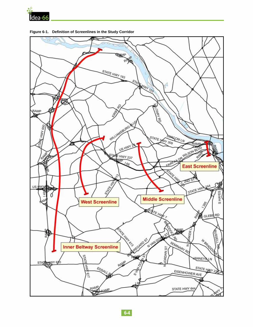
Figure 6-1 shows the screenline locations analyzed as part of this feasibility study. The first step in the calculation of V/C ratios is the determination of traffic volumes for each of the concepts analyzed. As stated above, only a subset of concepts was modeled to show the primary differences associated with the major solution categories. At this level of study, tolling strategies and variable pricing plans have not been developed. In theory, those tolls and pricing strategies would be set so as to maximize the flow of traffic on I-66 and not overwhelm parallel routes, so they would perform well from a capacity and mobility perspective. The subset of concepts modeled includes:
• 2005 Existing Conditions
• 2030 CLRP No-Build Concept - includes HOV-3 in the peak period and the opening of the Dulles Extension, among other regional improvements
6-4
Figure 6-1. Definition of Screenlines in the Study Corridor
6-5
• Roadway Widening Concept (labeled Concept A in Figures) – the addition of one westbound lane from Scott Street to Dulles Airport Access Highway (including HOV-3 in the PM peak period in the westbound direction)
• HOV-2 Changes (Concept B in Figures) – tests the effects of implementing HOV-2 in the AM westbound direction without any widening of I-66
• HOV-2 with Roadway Widening (Concept C in Figures) – measures the effectiveness of adding a lane, but keeping restriction level at HOV-2 westbound in the AM and PM peak period
• HOV-2 with Partial Widening, Removal of HOV Requirements West of Sycamore Street (Concept D in Figures) – measure the effect of retaining HOV-2 in AM and PM peak, with a widening only to Sycamore Street and lifting of HOV restrictions west of Sycamore (where Washington Boulevard on-ramp provides additional capacity on I-66)
• Bus Rapid Transit (Concept E in Figures) – tests implementation of BRT service in a barrier-separated additional lane on I-66
• Rail Transit (Concept F in Figures) – modeled new Metrorail service on track with new tunnel to Georgetown, including express service as defined in Core Capacity study known as the Blue Line Extension, included VRE increase in service as well
The first step in the technical evaluation and in the calculation of the V/C ratios is the projection of travel on the routes within the study area, including I-66 and the parallel arterials that are included in the model. As stated above, the screenline with the highest volume in the westbound direction is located just to the west of the Fairfax Drive on-ramp to I-66 in Ballston. This is the middle screenline and is used as the point of comparison in several of the evaluation criteria. This location also corresponds to the segment along I-66 that experiences the highest level of congestion in the westbound direction as the high volumes of traffic on Fairfax Drive merge into the I-66 mainline.
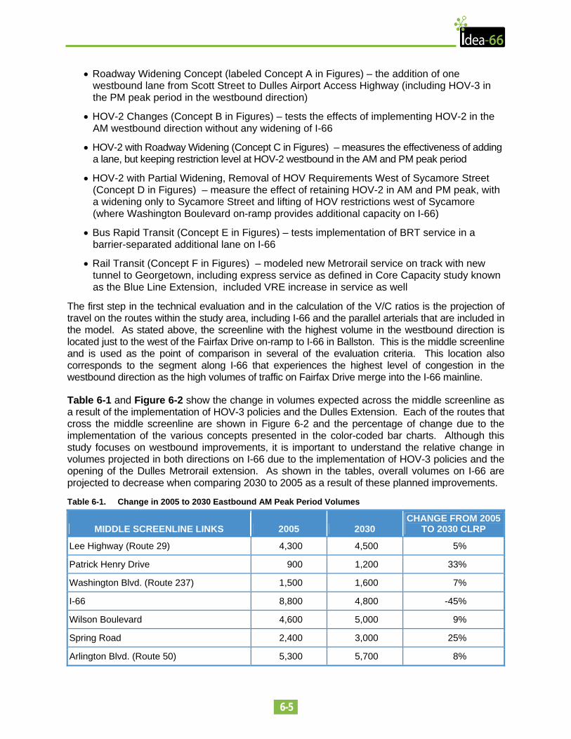
Table 6-1 and Figure 6-2 show the change in volumes expected across the middle screenline as a result of the implementation of HOV-3 policies and the Dulles Extension. Each of the routes that cross the middle screenline are shown in Figure 6-2 and the percentage of change due to the implementation of the various concepts presented in the color-coded bar charts. Although this study focuses on westbound improvements, it is important to understand the relative change in volumes projected in both directions on I-66 due to the implementation of HOV-3 policies and the opening of the Dulles Metrorail extension. As shown in the tables, overall volumes on I-66 are projected to decrease when comparing 2030 to 2005 as a result of these planned improvements.
Table 6-1. Change in 2005 to 2030 Eastbound AM Peak Period Volumes
MIDDLE SCREENLINE LINKS 2005 2030 CHANGE FROM 2005
TO 2030 CLRP
Lee Highway (Route 29) 4,300 4,500 5%
Patrick Henry Drive 900 1,200 33%
Washington Blvd. (Route 237) 1,500 1,600 7%
I-66 8,800 4,800 -45%
Wilson Boulevard 4,600 5,000 9%
Spring Road 2,400 3,000 25%
Arlington Blvd. (Route 50) 5,300 5,700 8%
6-6
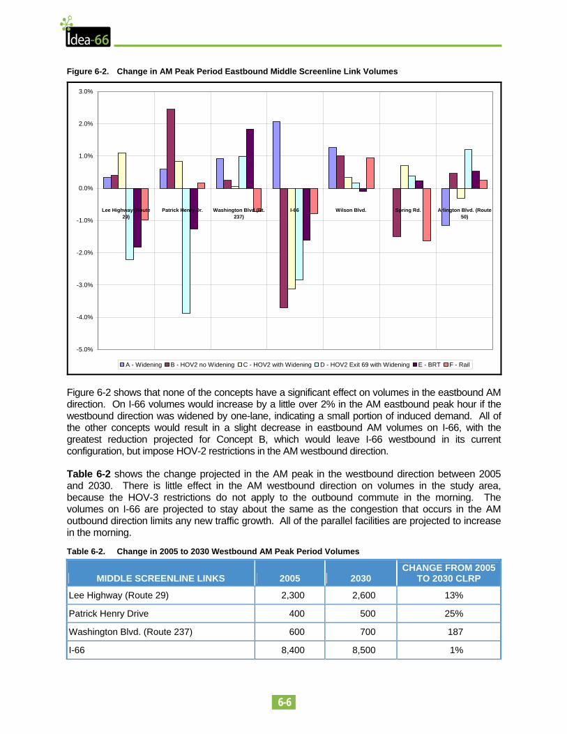
Figure 6-2. Change in AM Peak Period Eastbound Middle Screenline Link Volumes
-5.0%
-4.0%
-3.0%
-2.0%
-1.0%
0.0%
1.0%
2.0%
3.0%
Lee Highway (Route29)
Patrick Henry Dr. Washington Blvd (Rt.237)
I-66 Wilson Blvd. Spring Rd. Arlington Blvd. (Route50)
A - Widening B - HOV2 no Widening C - HOV2 with Widening D - HOV2 Exit 69 with Widening E - BRT F - Rail
Figure 6-2 shows that none of the concepts have a significant effect on volumes in the eastbound AM direction. On I-66 volumes would increase by a little over 2% in the AM eastbound peak hour if the westbound direction was widened by one-lane, indicating a small portion of induced demand. All of the other concepts would result in a slight decrease in eastbound AM volumes on I-66, with the greatest reduction projected for Concept B, which would leave I-66 westbound in its current configuration, but impose HOV-2 restrictions in the AM westbound direction.
Table 6-2 shows the change projected in the AM peak in the westbound direction between 2005 and 2030. There is little effect in the AM westbound direction on volumes in the study area, because the HOV-3 restrictions do not apply to the outbound commute in the morning. The volumes on I-66 are projected to stay about the same as the congestion that occurs in the AM outbound direction limits any new traffic growth. All of the parallel facilities are projected to increase in the morning.
Table 6-2. Change in 2005 to 2030 Westbound AM Peak Period Volumes
MIDDLE SCREENLINE LINKS 2005 2030 CHANGE FROM 2005
TO 2030 CLRP
Lee Highway (Route 29) 2,300 2,600 13%
Patrick Henry Drive 400 500 25%
Washington Blvd. (Route 237) 600 700 187
I-66 8,400 8,500 1%
6-7
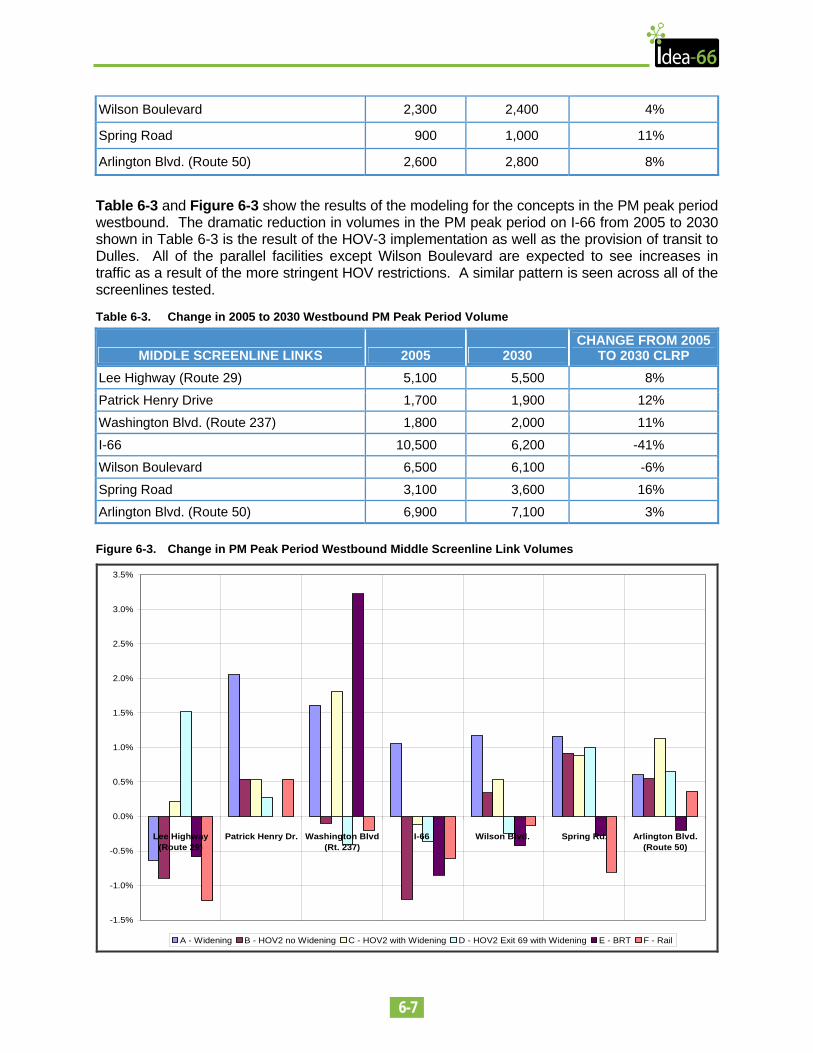
Wilson Boulevard 2,300 2,400 4%
Spring Road 900 1,000 11%
Arlington Blvd. (Route 50) 2,600 2,800 8%
Table 6-3 and Figure 6-3 show the results of the modeling for the concepts in the PM peak period westbound. The dramatic reduction in volumes in the PM peak period on I-66 from 2005 to 2030 shown in Table 6-3 is the result of the HOV-3 implementation as well as the provision of transit to Dulles. All of the parallel facilities except Wilson Boulevard are expected to see increases in traffic as a result of the more stringent HOV restrictions. A similar pattern is seen across all of the screenlines tested.
Table 6-3. Change in 2005 to 2030 Westbound PM Peak Period Volume
MIDDLE SCREENLINE LINKS 2005 2030 CHANGE FROM 2005
TO 2030 CLRP Lee Highway (Route 29) 5,100 5,500 8%
Patrick Henry Drive 1,700 1,900 12%
Washington Blvd. (Route 237) 1,800 2,000 11%
I-66 10,500 6,200 -41%
Wilson Boulevard 6,500 6,100 -6%
Spring Road 3,100 3,600 16%
Arlington Blvd. (Route 50) 6,900 7,100 3% Figure 6-3. Change in PM Peak Period Westbound Middle Screenline Link Volumes
-1.5%
-1.0%
-0.5%
0.0%
0.5%
1.0%
1.5%
2.0%
2.5%
3.0%
3.5%
Lee Highway(Route 29)
Patrick Henry Dr. Washington Blvd(Rt. 237)
I-66 Wilson Blvd. Spring Rd. Arlington Blvd.(Route 50)
A - Widening B - HOV2 no Widening C - HOV2 with Widening D - HOV2 Exit 69 with Widening E - BRT F - Rail
6-8
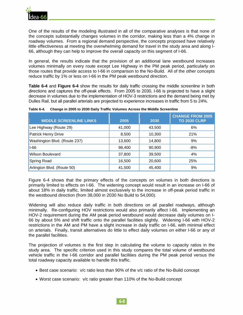
One of the results of the modeling illustrated in all of the comparative analyses is that none of the concepts substantially changes volumes in the corridor, making less than a 4% change in roadway volumes. From a regional demand perspective, the concepts proposed have relatively little effectiveness at meeting the overwhelming demand for travel in the study area and along I-66, although they can help to improve the overall capacity on this segment of I-66.
In general, the results indicate that the provision of an additional lane westbound increases volumes minimally on every route except Lee Highway in the PM peak period, particularly on those routes that provide access to I-66 in comparison to the No-Build. All of the other concepts reduce traffic by 1% or less on I-66 in the PM peak westbound direction.
Table 6-4 and Figure 6-4 show the results for daily traffic crossing the middle screenline in both directions and captures the off-peak effects. From 2005 to 2030, I-66 is projected to have a slight decrease in volumes due to the implementation of HOV-3 restrictions and the demand being met by Dulles Rail, but all parallel arterials are projected to experience increases in traffic from 5 to 24%.
Table 6-4. Change in 2005 to 2030 Daily Traffic Volumes Across the Middle Screenline
MIDDLE SCREENLINE LINKS 2005 2030 CHANGE FROM 2005
TO 2030 CLRP Lee Highway (Route 29) 41,000 43,500 6%
Patrick Henry Drive 8,500 10,300 21%
Washington Blvd. (Route 237) 13,600 14,800 9%
I-66 98,400 90,900 -8%
Wilson Boulevard 37,800 39,500 4%
Spring Road 16,500 20,600 25%
Arlington Blvd. (Route 50) 41,500 45,400 9%
Figure 6-4 shows that the primary effects of the concepts on volumes in both directions is primarily limited to effects on I-66. The widening concept would result in an increase on I-66 of about 18% in daily traffic, limited almost exclusively to the increase in off-peak period traffic in the westbound direction (from 38,000 in 2030 No Build to 54,000).
Widening will also reduce daily traffic in both directions on all parallel roadways, although minimally. Re-configuring HOV restrictions would also primarily affect I-66. Implementing an HOV-2 requirement during the AM peak period westbound would decrease daily volumes on I-66 by about 5% and shift traffic onto the parallel facilities slightly. Widening I-66 with HOV-2 restrictions in the AM and PM have a slight increase in daily traffic on I-66, with minimal effect on arterials. Finally, transit alternatives do little to effect daily volumes on either I-66 or any of the parallel facilities.
The projection of volumes is the first step in calculating the volume to capacity ratios in the study area. The specific criterion used in this study compares the total volume of westbound vehicle traffic in the I-66 corridor and parallel facilities during the PM peak period versus the total roadway capacity available to handle this traffic.
• Best case scenario: v/c ratio less than 90% of the v/c ratio of the No-Build concept
• Worst case scenario: v/c ratio greater than 110% of the No-Build concept
6-9
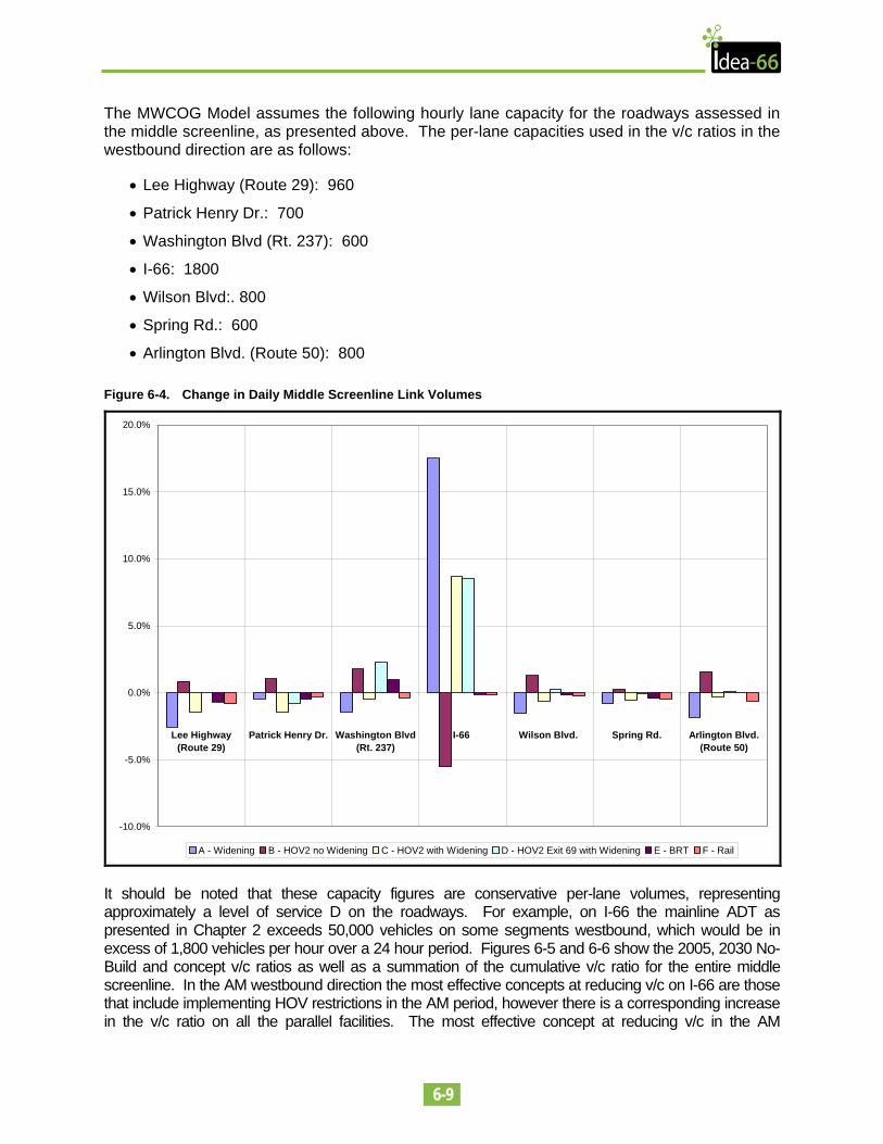
The MWCOG Model assumes the following hourly lane capacity for the roadways assessed in the middle screenline, as presented above. The per-lane capacities used in the v/c ratios in the westbound direction are as follows:
• Lee Highway (Route 29): 960
• Patrick Henry Dr.: 700
• Washington Blvd (Rt. 237): 600
• I-66: 1800
• Wilson Blvd:. 800
• Spring Rd.: 600
• Arlington Blvd. (Route 50): 800 Figure 6-4. Change in Daily Middle Screenline Link Volumes
-10.0%
-5.0%
0.0%
5.0%
10.0%
15.0%
20.0%
Lee Highway(Route 29)
Patrick Henry Dr. Washington Blvd(Rt. 237)
I-66 Wilson Blvd. Spring Rd. Arlington Blvd.(Route 50)
A - Widening B - HOV2 no Widening C - HOV2 with Widening D - HOV2 Exit 69 with Widening E - BRT F - Rail
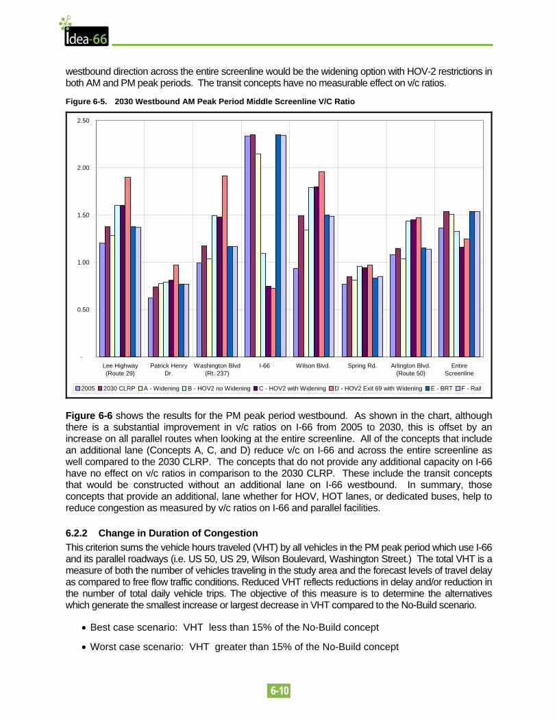
It should be noted that these capacity figures are conservative per-lane volumes, representing approximately a level of service D on the roadways. For example, on I-66 the mainline ADT as presented in Chapter 2 exceeds 50,000 vehicles on some segments westbound, which would be in excess of 1,800 vehicles per hour over a 24 hour period. Figures 6-5 and 6-6 show the 2005, 2030 No-Build and concept v/c ratios as well as a summation of the cumulative v/c ratio for the entire middle screenline. In the AM westbound direction the most effective concepts at reducing v/c on I-66 are those that include implementing HOV restrictions in the AM period, however there is a corresponding increase in the v/c ratio on all the parallel facilities. The most effective concept at reducing v/c in the AM
6-10
westbound direction across the entire screenline would be the widening option with HOV-2 restrictions in both AM and PM peak periods. The transit concepts have no measurable effect on v/c ratios.
Figure 6-5. 2030 Westbound AM Peak Period Middle Screenline V/C Ratio
-
0.50
1.00
1.50
2.00
2.50
Lee Highway(Route 29)
Patrick HenryDr.
Washington Blvd(Rt. 237)
I-66 Wilson Blvd. Spring Rd. Arlington Blvd.(Route 50)
EntireScreenline
2005 2030 CLRP A - Widening B - HOV2 no Widening C - HOV2 with Widening D - HOV2 Exit 69 with Widening E - BRT F - Rail
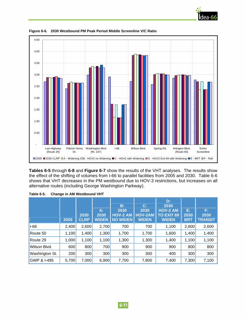
Figure 6-6 shows the results for the PM peak period westbound. As shown in the chart, although there is a substantial improvement in v/c ratios on I-66 from 2005 to 2030, this is offset by an increase on all parallel routes when looking at the entire screenline. All of the concepts that include an additional lane (Concepts A, C, and D) reduce v/c on I-66 and across the entire screenline as well compared to the 2030 CLRP. The concepts that do not provide any additional capacity on I-66 have no effect on v/c ratios in comparison to the 2030 CLRP. These include the transit concepts that would be constructed without an additional lane on I-66 westbound. In summary, those concepts that provide an additional, lane whether for HOV, HOT lanes, or dedicated buses, help to reduce congestion as measured by v/c ratios on I-66 and parallel facilities.
6.2.2 Change in Duration of Congestion This criterion sums the vehicle hours traveled (VHT) by all vehicles in the PM peak period which use I-66 and its parallel roadways (i.e. US 50, US 29, Wilson Boulevard, Washington Street.) The total VHT is a measure of both the number of vehicles traveling in the study area and the forecast levels of travel delay as compared to free flow traffic conditions. Reduced VHT reflects reductions in delay and/or reduction in the number of total daily vehicle trips. The objective of this measure is to determine the alternatives which generate the smallest increase or largest decrease in VHT compared to the No-Build scenario.
• Best case scenario: VHT less than 15% of the No-Build concept
• Worst case scenario: VHT greater than 15% of the No-Build concept
6-11
Figure 6-6. 2030 Westbound PM Peak Period Middle Screenline V/C Ratio
-
0.50
1.00
1.50
2.00
2.50
3.00
3.50
4.00
4.50
Lee Highway(Route 29)
Patrick HenryDr.
Washington Blvd(Rt. 237)
I-66 Wilson Blvd. Spring Rd. Arlington Blvd.(Route 50)
EntireScreenline
2005 2030 CLRP A - Widening B - HOV2 no Widening C - HOV2 with Widening D - HOV2 Exit 69 with Widening E - BRT F - Rail
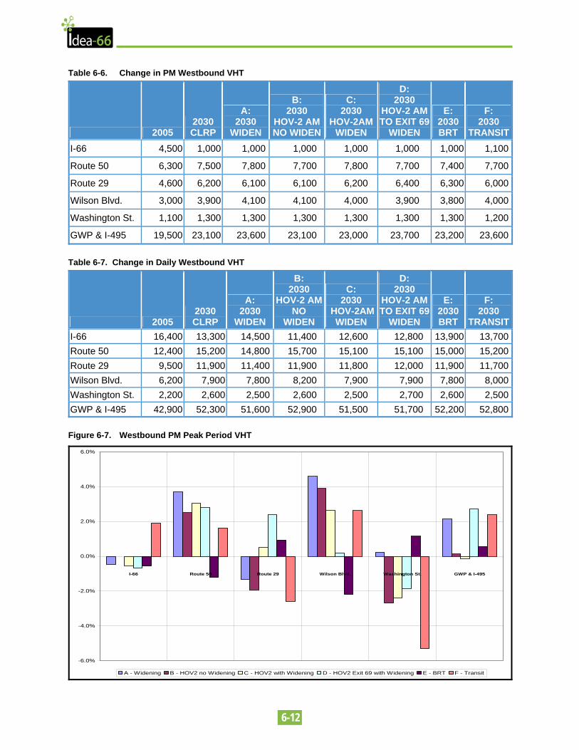
Tables 6-5 through 6-8 and Figure 6-7 show the results of the VHT analyses. The results show the effect of the shifting of volumes from I-66 to parallel facilities from 2005 and 2030. Table 6-6 shows that VHT decreases in the PM westbound due to HOV-3 restrictions, but increases on all alternative routes (including George Washington Parkway).
Table 6-5. Change in AM Westbound VHT
2005 2030 CLRP
A: 2030
WIDEN
B: 2030
HOV-2 AM NO WIDEN
C: 2030
HOV-2AM WIDEN
D: 2030
HOV-2 AM TO EXIT 69
WIDEN
E: 2030 BRT
F: 2030
TRANSITI-66 2,400 2,600 2,700 700 700 1,100 2,600 2,600
Route 50 1,100 1,400 1,300 1,700 1,700 1,600 1,400 1,400
Route 29 1,000 1,100 1,100 1,300 1,300 1,400 1,100 1,100
Wilson Blvd. 600 800 700 900 900 900 800 800
Washington St. 200 300 300 300 300 400 300 300
GWP & I-495 5,700 7,000 6,900 7,700 7,800 7,400 7,300 7,100
6-12
Table 6-6. Change in PM Westbound VHT
2005 2030 CLRP
A: 2030
WIDEN
B: 2030
HOV-2 AM NO WIDEN
C: 2030
HOV-2AM WIDEN
D: 2030
HOV-2 AM TO EXIT 69
WIDEN
E: 2030 BRT
F: 2030
TRANSITI-66 4,500 1,000 1,000 1,000 1,000 1,000 1,000 1,100
Route 50 6,300 7,500 7,800 7,700 7,800 7,700 7,400 7,700
Route 29 4,600 6,200 6,100 6,100 6,200 6,400 6,300 6,000
Wilson Blvd. 3,000 3,900 4,100 4,100 4,000 3,900 3,800 4,000
Washington St. 1,100 1,300 1,300 1,300 1,300 1,300 1,300 1,200
GWP & I-495 19,500 23,100 23,600 23,100 23,000 23,700 23,200 23,600 Table 6-7. Change in Daily Westbound VHT
2005 2030 CLRP
A: 2030
WIDEN
B: 2030
HOV-2 AM NO
WIDEN
C: 2030
HOV-2AM WIDEN
D: 2030
HOV-2 AM TO EXIT 69
WIDEN
E: 2030 BRT
F: 2030
TRANSITI-66 16,400 13,300 14,500 11,400 12,600 12,800 13,900 13,700Route 50 12,400 15,200 14,800 15,700 15,100 15,100 15,000 15,200Route 29 9,500 11,900 11,400 11,900 11,800 12,000 11,900 11,700Wilson Blvd. 6,200 7,900 7,800 8,200 7,900 7,900 7,800 8,000Washington St. 2,200 2,600 2,500 2,600 2,500 2,700 2,600 2,500GWP & I-495 42,900 52,300 51,600 52,900 51,500 51,700 52,200 52,800 Figure 6-7. Westbound PM Peak Period VHT
-6.0%
-4.0%
-2.0%
0.0%
2.0%
4.0%
6.0%
I-66 Route 50 Route 29 Wilson Blvd. Washington St. GWP & I-495
A - Widening B - HOV2 no Widening C - HOV2 with Widening D - HOV2 Exit 69 with Widening E - BRT F - Transit
6-13
In summarizing the VHT results as a measurement of the duration of congestion, none of the concepts greatly improve upon the 2030 CLRP baseline. There is some improvement for some of the widening concepts which although they increase VHT slightly on I-66, reduce VHT on most of the parallel routes.
6.2.3 Change in Incident Occurrences This is a qualitative measurement, evaluating the potential for improvements to increase the safety of areas in the corridor with a history of traffic accidents.
• Best case scenario: concept would improve sight distances, reduce weaving movements, or provide other enhancements which would improve the safety of westbound I-66
• Worst case scenario: concept would reduce sight distances, narrow lane widths, or create other hazards which could increase the likelihood of accidents
This is a difficult measurement to quantify since incidents are often the result of random accidents. For the purposes of the comparison chart, only those concepts that are specifically designed to improve safety such as improving sight distances, enhancing shoulders, and lane balancing through improving merging and weaving areas are considered to perform better than the 2030 CLRP.
6.2.4 Change in Evacuation Potential This criterion measures the one-hour westbound person- capacity of I-66, its parallel roadways, and transit systems with dedicated lanes or guideways (i.e., Metrorail and BRT in a dedicated bus lane).
• Best case scenario: 15% or more person-capacity than the No-Build concept
• Worst case scenario: Reduction in person-capacity over the No-Build concept
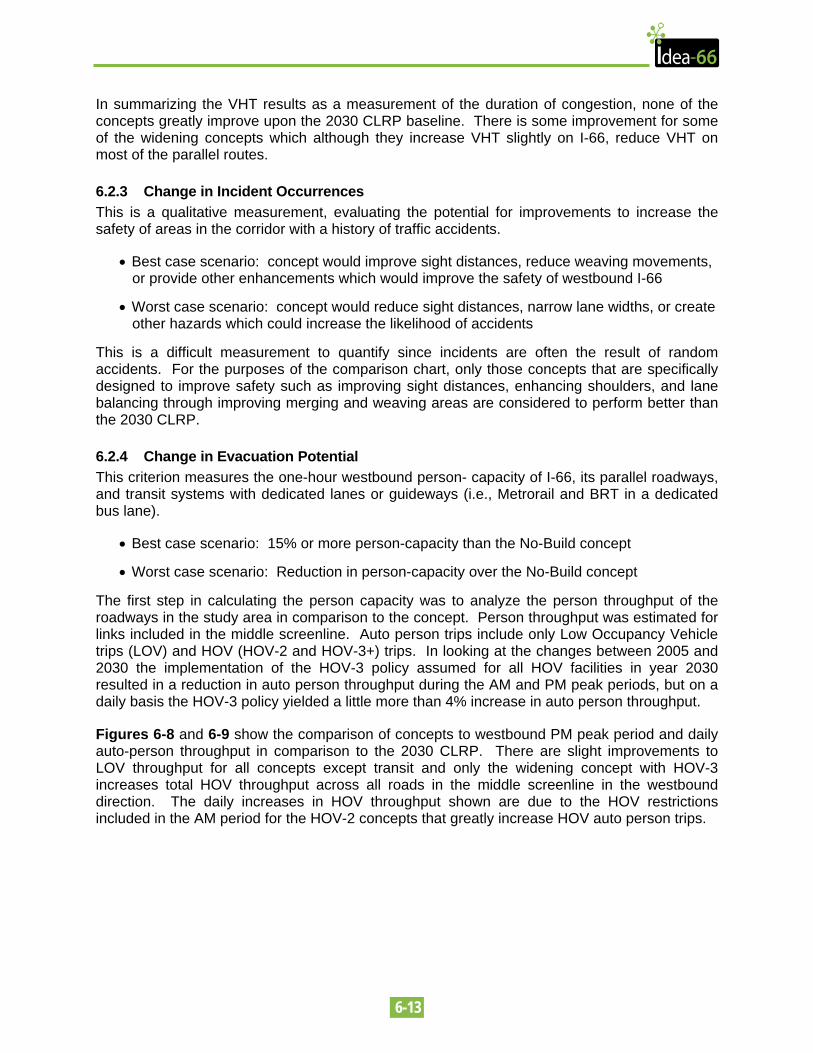
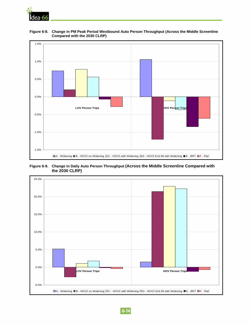
The first step in calculating the person capacity was to analyze the person throughput of the roadways in the study area in comparison to the concept. Person throughput was estimated for links included in the middle screenline. Auto person trips include only Low Occupancy Vehicle trips (LOV) and HOV (HOV-2 and HOV-3+) trips. In looking at the changes between 2005 and 2030 the implementation of the HOV-3 policy assumed for all HOV facilities in year 2030 resulted in a reduction in auto person throughput during the AM and PM peak periods, but on a daily basis the HOV-3 policy yielded a little more than 4% increase in auto person throughput.
Figures 6-8 and 6-9 show the comparison of concepts to westbound PM peak period and daily auto-person throughput in comparison to the 2030 CLRP. There are slight improvements to LOV throughput for all concepts except transit and only the widening concept with HOV-3 increases total HOV throughput across all roads in the middle screenline in the westbound direction. The daily increases in HOV throughput shown are due to the HOV restrictions included in the AM period for the HOV-2 concepts that greatly increase HOV auto person trips.
6-14
Figure 6-8. Change in PM Peak Period Westbound Auto Person Throughput (Across the Middle Screenline Compared with the 2030 CLRP)
-1.5%
-1.0%
-0.5%
0.0%
0.5%
1.0%
1.5%
LOV Person Trips HOV Person Trips
A - Widening B - HOV2 no Widening C - HOV2 with Widening D - HOV2 Exit 69 with Widening E - BRT F - Rail
Figure 6-9. Change in Daily Auto Person Throughput (Across the Middle Screenline Compared with the 2030 CLRP)
-5.0%
0.0%
5.0%
10.0%
15.0%
20.0%
25.0%
LOV Person Trips HOV Person Trips
A - Widening B - HOV2 no Widening C - HOV2 with Widening D - HOV2 Exit 69 with Widening E - BRT F - Rail
6-15
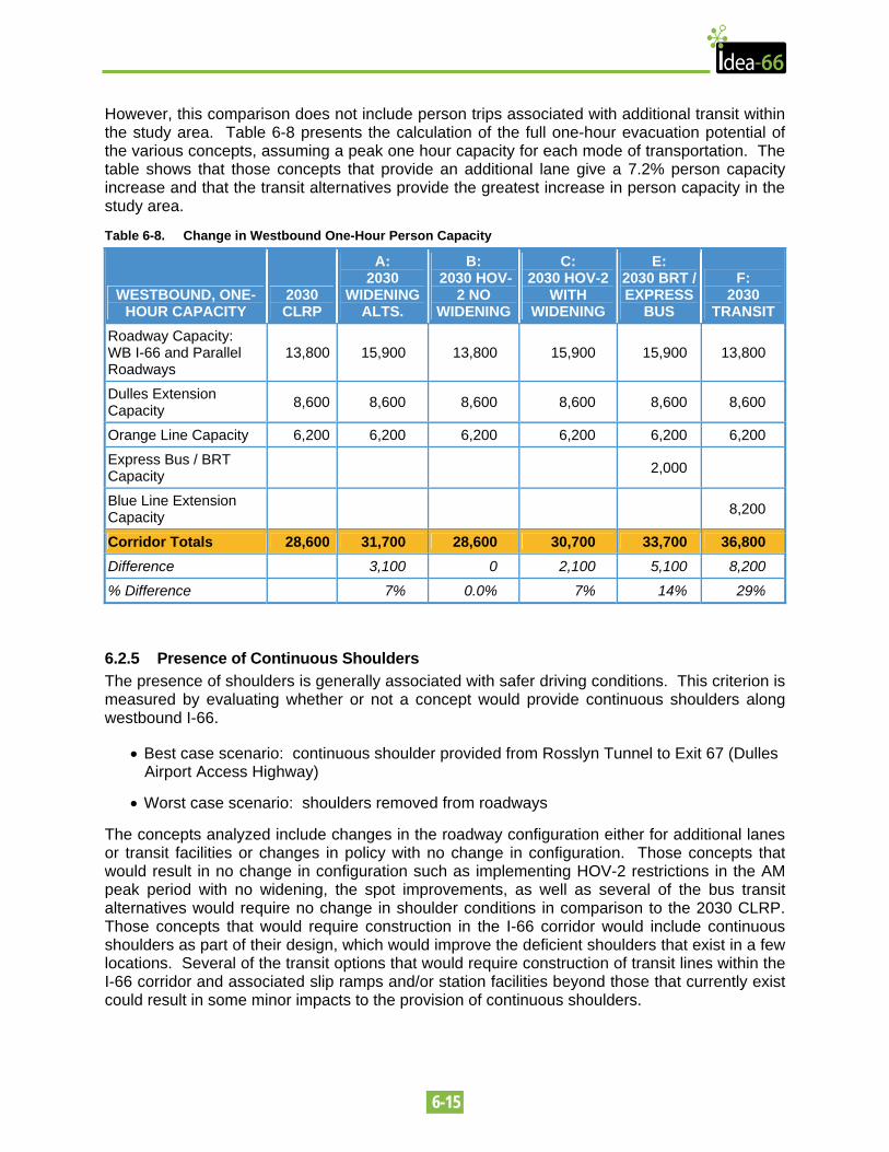
However, this comparison does not include person trips associated with additional transit within the study area. Table 6-8 presents the calculation of the full one-hour evacuation potential of the various concepts, assuming a peak one hour capacity for each mode of transportation. The table shows that those concepts that provide an additional lane give a 7.2% person capacity increase and that the transit alternatives provide the greatest increase in person capacity in the study area.
Table 6-8. Change in Westbound One-Hour Person Capacity
WESTBOUND, ONE-HOUR CAPACITY
2030 CLRP
A: 2030
WIDENINGALTS.
B: 2030 HOV-
2 NO WIDENING
C: 2030 HOV-2
WITH WIDENING
E: 2030 BRT / EXPRESS
BUS
F: 2030
TRANSIT Roadway Capacity: WB I-66 and Parallel Roadways
13,800 15,900 13,800 15,900 15,900 13,800
Dulles Extension Capacity 8,600 8,600 8,600 8,600 8,600 8,600
Orange Line Capacity 6,200 6,200 6,200 6,200 6,200 6,200
Express Bus / BRT Capacity 2,000
Blue Line Extension Capacity 8,200
Corridor Totals 28,600 31,700 28,600 30,700 33,700 36,800 Difference 3,100 0 2,100 5,100 8,200 % Difference 7% 0.0% 7% 14% 29%
6.2.5 Presence of Continuous Shoulders The presence of shoulders is generally associated with safer driving conditions. This criterion is measured by evaluating whether or not a concept would provide continuous shoulders along westbound I-66.
• Best case scenario: continuous shoulder provided from Rosslyn Tunnel to Exit 67 (Dulles Airport Access Highway)
• Worst case scenario: shoulders removed from roadways
The concepts analyzed include changes in the roadway configuration either for additional lanes or transit facilities or changes in policy with no change in configuration. Those concepts that would result in no change in configuration such as implementing HOV-2 restrictions in the AM peak period with no widening, the spot improvements, as well as several of the bus transit alternatives would require no change in shoulder conditions in comparison to the 2030 CLRP. Those concepts that would require construction in the I-66 corridor would include continuous shoulders as part of their design, which would improve the deficient shoulders that exist in a few locations. Several of the transit options that would require construction of transit lines within the I-66 corridor and associated slip ramps and/or station facilities beyond those that currently exist could result in some minor impacts to the provision of continuous shoulders.
6-16
6.2.6 Change in Accessibility / Travel Time This criterion is measured using the regional transportation model. The model treats the Washington metropolitan area as a set of Traffic Analysis Zones (TAZs.) Changes in accessibility are measured by the model by determining the number of TAZs which are within 30 minutes’ transit and vehicular travel time of Rosslyn and by looking at origins and destination changes associated with the concepts.
• Best case scenario: 15% more TAZs accessible by transit than the No-Build concept
• Worst case scenario: 15% fewer TAZs accessible by transit than the No-Build concept
The accessibility impact of the alternatives was measured in terms of the change in the number of trips that are within 30 minutes of travel to and from the vicinity of the Rosslyn Metrorail Station (MWCOG TAZ 1236). As shown in Table 6-9, the biggest improvement in transit accessibility for daily home-based work trips is provided by the Blue Line Extension followed by the three HOV alternatives. The changes in the number of morning peak period vehicle trips to and from Rosslyn for all the modeled alternatives compared with the No-Build scenario were found to be negligible (less than 0.02%).
Table 6-9. Change in Transit Accessibility Compared with 2030 No-Build
MODELED ALTERNATIVE CHANGE IN DAILY HOME-BASED WORK TRANSIT ACCESSIBILITY*
Concept A: Road Widening 0.9%
Concept B: HOV-2 Westbound 2.0%
Concept C: HOV-2 Westbound with Widening 1.3%
Concept D: HOV-2 Westbound to Exit 69 with Widening 1.5%
Concept E: BRT Alternative 1.2%
Concept F: Blue Line Extension 8.2%
For the purpose of analyzing the change in travel patterns in the corridor, select link analyses were performed at the mainline section of I-66 just west of George Mason Drive. This location is approximately at the middle of the study corridor. Around half of the I-66 users are coming from DC / MD during the AM peak period. Approximately 40% are destined to Arlington County.
Table 6-10. Origin of Westbound AM Peak Period Users of I-66
TRIP ORIGIN CHANGE FROM 2005 TO 2030 CLRP DC/MD 4%
Arlington 3%
Fairfax 3%
Alexandria Nil
Loudoun/Prince William -5%
Rest of VA/Externals 92%
6-17
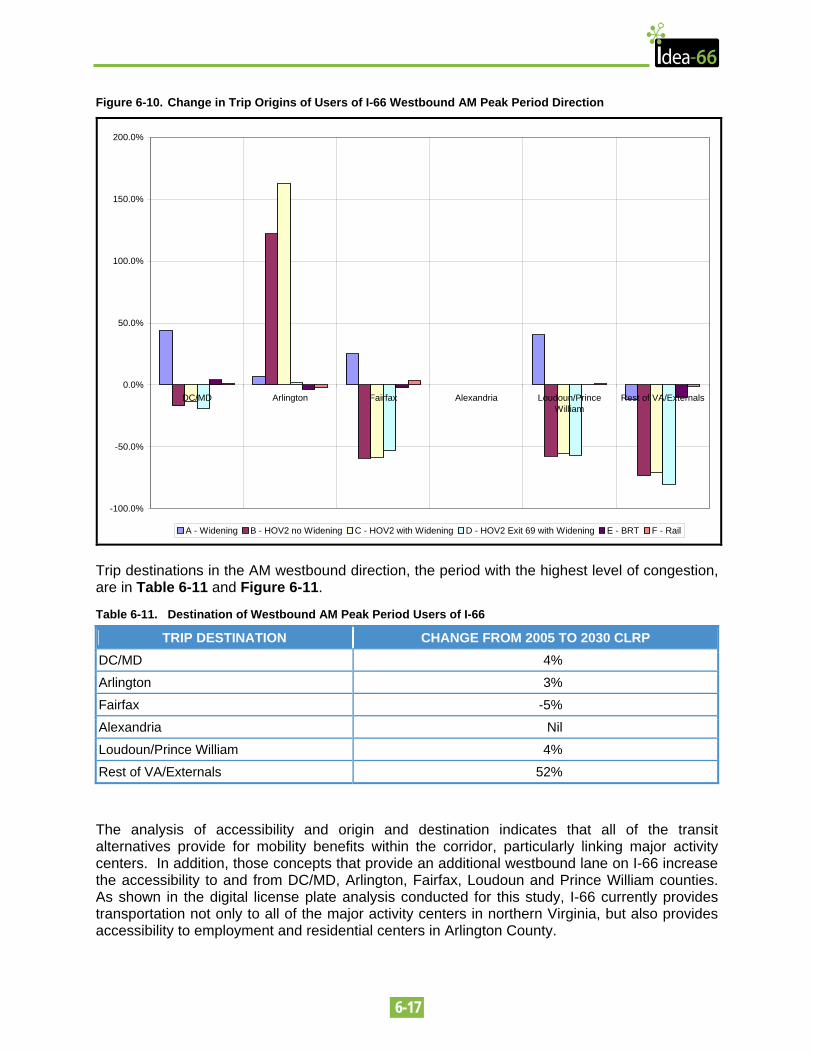
Figure 6-10. Change in Trip Origins of Users of I-66 Westbound AM Peak Period Direction
-100.0%
-50.0%
0.0%
50.0%
100.0%
150.0%
200.0%
DC/MD Arlington Fairfax Alexandria Loudoun/PrinceWilliam
Rest of VA/Externals
A - Widening B - HOV2 no Widening C - HOV2 with Widening D - HOV2 Exit 69 with Widening E - BRT F - Rail
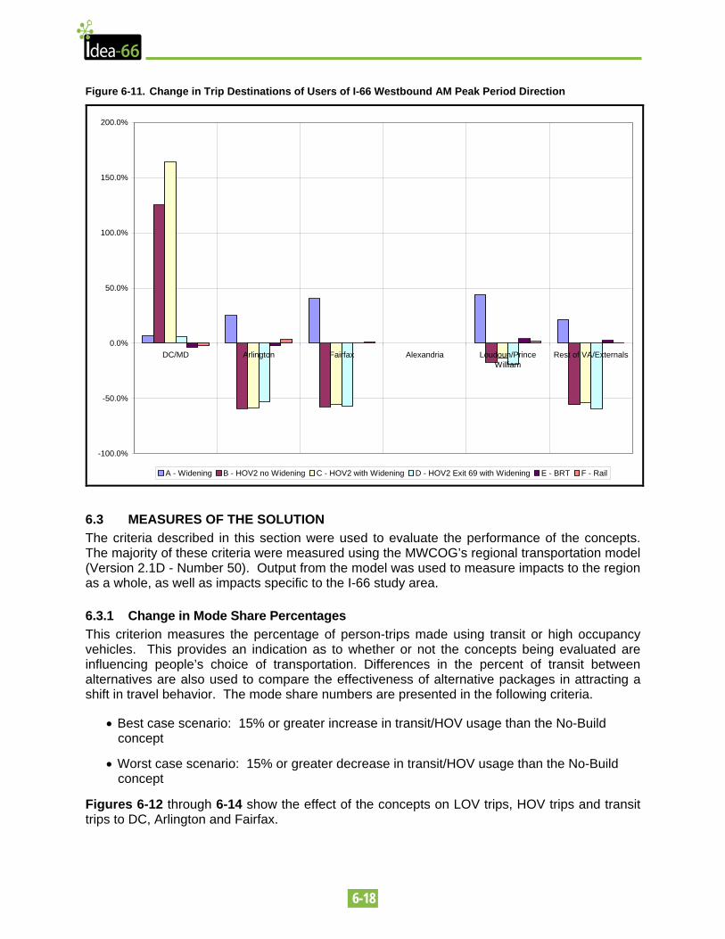
Trip destinations in the AM westbound direction, the period with the highest level of congestion, are in Table 6-11 and Figure 6-11.
Table 6-11. Destination of Westbound AM Peak Period Users of I-66
TRIP DESTINATION CHANGE FROM 2005 TO 2030 CLRP DC/MD 4%
Arlington 3%
Fairfax -5%
Alexandria Nil
Loudoun/Prince William 4%
Rest of VA/Externals 52%
The analysis of accessibility and origin and destination indicates that all of the transit alternatives provide for mobility benefits within the corridor, particularly linking major activity centers. In addition, those concepts that provide an additional westbound lane on I-66 increase the accessibility to and from DC/MD, Arlington, Fairfax, Loudoun and Prince William counties. As shown in the digital license plate analysis conducted for this study, I-66 currently provides transportation not only to all of the major activity centers in northern Virginia, but also provides accessibility to employment and residential centers in Arlington County.
6-18
Figure 6-11. Change in Trip Destinations of Users of I-66 Westbound AM Peak Period Direction
-100.0%
-50.0%
0.0%
50.0%
100.0%
150.0%
200.0%
DC/MD Arlington Fairfax Alexandria Loudoun/PrinceWilliam
Rest of VA/Externals
A - Widening B - HOV2 no Widening C - HOV2 with Widening D - HOV2 Exit 69 with Widening E - BRT F - Rail
6.3 MEASURES OF THE SOLUTION The criteria described in this section were used to evaluate the performance of the concepts. The majority of these criteria were measured using the MWCOG’s regional transportation model (Version 2.1D - Number 50). Output from the model was used to measure impacts to the region as a whole, as well as impacts specific to the I-66 study area.
6.3.1 Change in Mode Share Percentages This criterion measures the percentage of person-trips made using transit or high occupancy vehicles. This provides an indication as to whether or not the concepts being evaluated are influencing people’s choice of transportation. Differences in the percent of transit between alternatives are also used to compare the effectiveness of alternative packages in attracting a shift in travel behavior. The mode share numbers are presented in the following criteria.
• Best case scenario: 15% or greater increase in transit/HOV usage than the No-Build concept
• Worst case scenario: 15% or greater decrease in transit/HOV usage than the No-Build concept
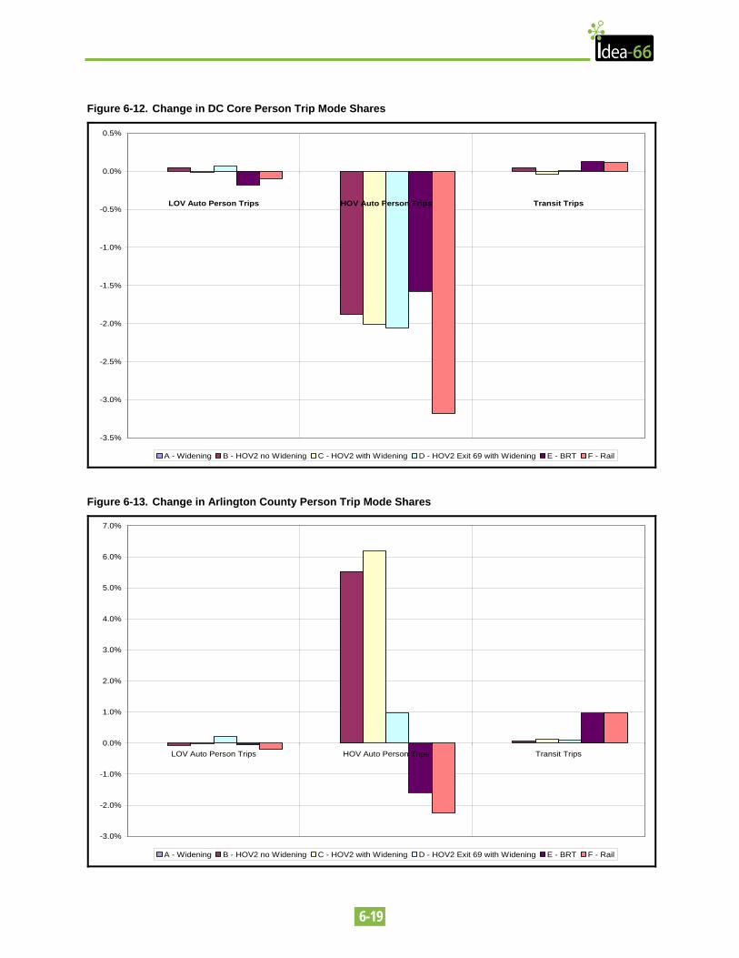
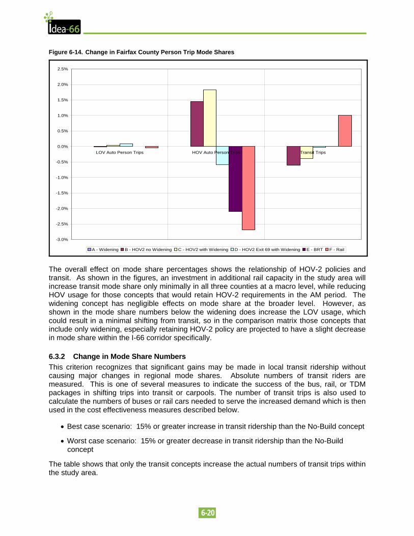
Figures 6-12 through 6-14 show the effect of the concepts on LOV trips, HOV trips and transit trips to DC, Arlington and Fairfax.
6-19
Figure 6-12. Change in DC Core Person Trip Mode Shares
-3.5%
-3.0%
-2.5%
-2.0%
-1.5%
-1.0%
-0.5%
0.0%
0.5%
LOV Auto Person Trips HOV Auto Person Trips Transit Trips
A - Widening B - HOV2 no Widening C - HOV2 with Widening D - HOV2 Exit 69 with Widening E - BRT F - Rail
Figure 6-13. Change in Arlington County Person Trip Mode Shares
-3.0%
-2.0%
-1.0%
0.0%
1.0%
2.0%
3.0%
4.0%
5.0%
6.0%
7.0%
LOV Auto Person Trips HOV Auto Person Trips Transit Trips
A - Widening B - HOV2 no Widening C - HOV2 with Widening D - HOV2 Exit 69 with Widening E - BRT F - Rail
6-20
Figure 6-14. Change in Fairfax County Person Trip Mode Shares
-3.0%
-2.5%
-2.0%
-1.5%
-1.0%
-0.5%
0.0%
0.5%
1.0%
1.5%
2.0%
2.5%
LOV Auto Person Trips HOV Auto Person Trips Transit Trips
A - Widening B - HOV2 no Widening C - HOV2 with Widening D - HOV2 Exit 69 with Widening E - BRT F - Rail
The overall effect on mode share percentages shows the relationship of HOV-2 policies and transit. As shown in the figures, an investment in additional rail capacity in the study area will increase transit mode share only minimally in all three counties at a macro level, while reducing HOV usage for those concepts that would retain HOV-2 requirements in the AM period. The widening concept has negligible effects on mode share at the broader level. However, as shown in the mode share numbers below the widening does increase the LOV usage, which could result in a minimal shifting from transit, so in the comparison matrix those concepts that include only widening, especially retaining HOV-2 policy are projected to have a slight decrease in mode share within the I-66 corridor specifically.
6.3.2 Change in Mode Share Numbers This criterion recognizes that significant gains may be made in local transit ridership without causing major changes in regional mode shares. Absolute numbers of transit riders are measured. This is one of several measures to indicate the success of the bus, rail, or TDM packages in shifting trips into transit or carpools. The number of transit trips is also used to calculate the numbers of buses or rail cars needed to serve the increased demand which is then used in the cost effectiveness measures described below.
• Best case scenario: 15% or greater increase in transit ridership than the No-Build concept
• Worst case scenario: 15% or greater decrease in transit ridership than the No-Build concept
The table shows that only the transit concepts increase the actual numbers of transit trips within the study area.
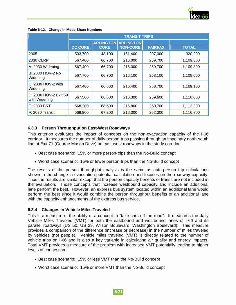
6-21
Table 6-12. Change in Mode Share Numbers
TRANSIT TRIPS
DC CORE ARLINGTON
CORE ARLINGTON NON-CORE FAIRFAX TOTAL
2005 503,700 48,100 161,400 207,000 920,200
2030 CLRP 567,400 66,700 216,000 259,700 1,109,800
A: 2030 Widening 567,400 66,700 216,000 259,700 1,109,800
B: 2030 HOV-2 No Widening 567,700 66,700 216,100 258,100 1,108,600
C: 2030 HOV-2 with Widening 567,400 66,600 216,400 258,700 1,109,100
D: 2030 HOV-2 Exit 69 with Widening 567,500 66,600 216,300 259,600 1,110,000
E: 2030 BRT 568,200 68,600 216,800 259,700 1,113,300
F: 2030 Transit 568,900 67,200 218,300 262,300 1,116,700
6.3.3 Person Throughput on East-West Roadways This criterion evaluates the impact of concepts on the non-evacuation capacity of the I-66 corridor. It measures the number of daily person-trips passing through an imaginary north-south line at Exit 71 (George Mason Drive) on east-west roadways in the study corridor.
• Best case scenario: 15% or more person-trips than the No-Build concept
• Worst case scenario: 15% or fewer person-trips than the No-Build concept
The results of the person throughput analysis is the same as auto-person trip calculations shown in the change in evacuation potential calculation and focuses on the roadway capacity. Thus the results are similar except that the person capacity benefits of transit are not included in the evaluation. Those concepts that increase westbound capacity and include an additional lane perform the best. However, an express bus system located within an additional lane would perform the best since it would combine the person throughput benefits of an additional lane with the capacity enhancements of the express bus service.
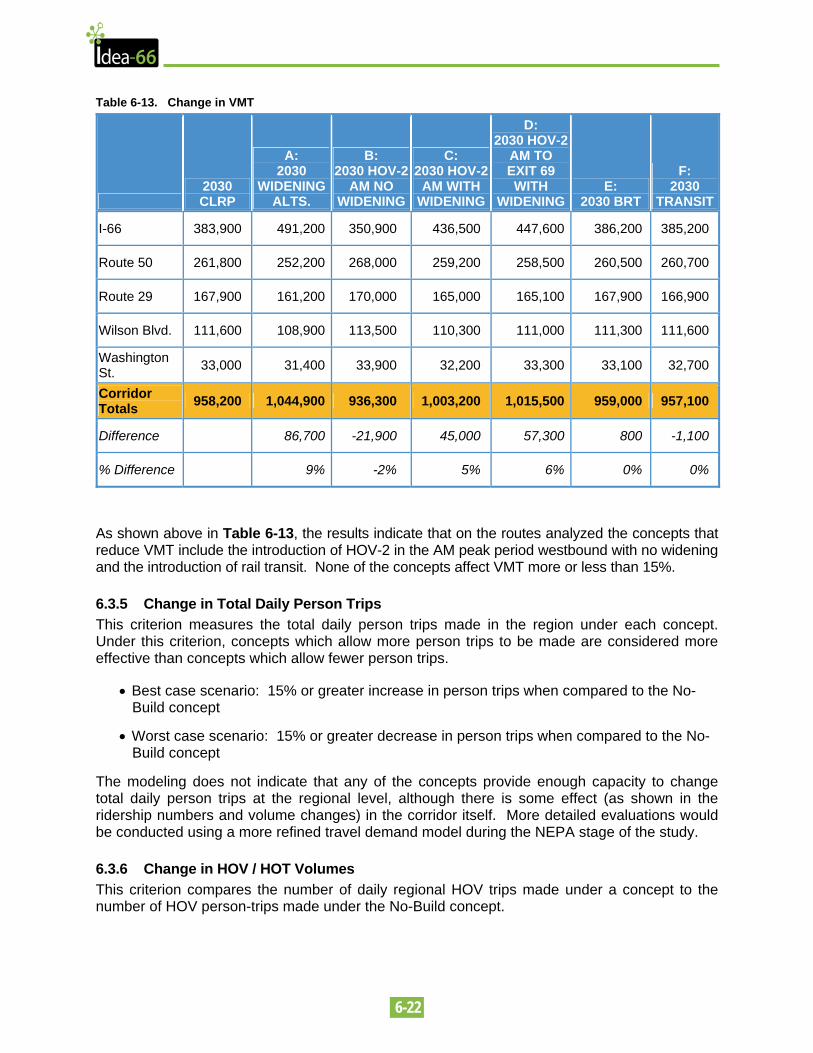
6.3.4 Changes in Vehicle Miles Traveled This is a measure of the ability of a concept to “take cars off the road”. It measures the daily Vehicle Miles Traveled (VMT) for both the eastbound and westbound lanes of I-66 and its parallel roadways (US 50, US 29, Wilson Boulevard, Washington Boulevard). This measure provides a comparison of the difference (increase or decrease) in the number of miles traveled by vehicles (not people). Vehicle miles traveled (VMT) is directly related to the number of vehicle trips on I-66 and is also a key variable in calculating air quality and energy impacts. Total VMT provides a measure of the problem with increased VMT potentially leading to higher levels of congestion.
• Best case scenario: 15% or less VMT than the No-Build concept
• Worst case scenario: 15% or more VMT than the No-Build concept
6-22
Table 6-13. Change in VMT
2030 CLRP
A: 2030
WIDENING ALTS.
B: 2030 HOV-2
AM NO WIDENING
C: 2030 HOV-2
AM WITH WIDENING
D: 2030 HOV-2
AM TO EXIT 69 WITH
WIDENINGE:
2030 BRT
F: 2030
TRANSIT
I-66 383,900 491,200 350,900 436,500 447,600 386,200 385,200
Route 50 261,800 252,200 268,000 259,200 258,500 260,500 260,700
Route 29 167,900 161,200 170,000 165,000 165,100 167,900 166,900
Wilson Blvd. 111,600 108,900 113,500 110,300 111,000 111,300 111,600
Washington St. 33,000 31,400 33,900 32,200 33,300 33,100 32,700
Corridor Totals 958,200 1,044,900 936,300 1,003,200 1,015,500 959,000 957,100
Difference 86,700 -21,900 45,000 57,300 800 -1,100
% Difference 9% -2% 5% 6% 0% 0%
As shown above in Table 6-13, the results indicate that on the routes analyzed the concepts that reduce VMT include the introduction of HOV-2 in the AM peak period westbound with no widening and the introduction of rail transit. None of the concepts affect VMT more or less than 15%.
6.3.5 Change in Total Daily Person Trips This criterion measures the total daily person trips made in the region under each concept. Under this criterion, concepts which allow more person trips to be made are considered more effective than concepts which allow fewer person trips.
• Best case scenario: 15% or greater increase in person trips when compared to the No-Build concept
• Worst case scenario: 15% or greater decrease in person trips when compared to the No-Build concept
The modeling does not indicate that any of the concepts provide enough capacity to change total daily person trips at the regional level, although there is some effect (as shown in the ridership numbers and volume changes) in the corridor itself. More detailed evaluations would be conducted using a more refined travel demand model during the NEPA stage of the study.
6.3.6 Change in HOV / HOT Volumes This criterion compares the number of daily regional HOV trips made under a concept to the number of HOV person-trips made under the No-Build concept.
6-23
• Best case scenario: 15% or greater increase in HOV person trips when compared to the No-Build concept
• Worst case scenario: 15% or greater decrease in HOV person trips when compared to the No-Build concept
The results of the modeling that show HOV levels are shown in Figures 6-12 through 6-14 above. All of the concepts that include new HOV restrictions in the AM peak westbound direction are projected to increase overall HOV usage, since there will be HOV volumes in the AM peak. The increases would be greater for HOT lanes.
6.3.7 Network Connectivity Improvement This is a qualitative assessment of a concept’s ability to improve connections between regional activity centers and the regional transportation system.
• Best case scenario: The concept creates a new connection between several existing activity centers in the study area
• Worst case scenario: The concept degrades or removes connections between activity centers in the study area
The only concepts that do not improve connections between activity centers would be the HOV concepts that do not include a widening. The concepts all include some form of increased HOV restrictions, either in the AM period westbound or as daily restrictions. In general, without new capacity the implementation of additional westbound travel restrictions will not improve connections to activity centers. The concepts that provide the greatest improvement in network connectivity are the transit concepts that provide new transit linkages between activity centers. These include a new Metrorail connection to Georgetown, as well as increase in bus service that can provide access to a variety of new activity centers and offers the greatest connectivity benefits in the corridor.
6.4 MEASURES OF COMMUNITY AND ENVIRONMENTAL IMPACT One of the guiding principles of this feasibility study is to restrict proposed improvements to the existing right-of-way of I-66. Several concepts met this goal; however, some concepts recommended by stakeholders and the general public would require additional right-of-way and could potentially cause more significant direct impacts. The following criteria were used to measure the effects of the proposed concepts upon the natural, cultural and socio-economic resources of the study area. Categories recognize both direct impacts due to the construction of new facilities as well as the indirect effects that are associated with transportation operations.
6.4.1 Work within Existing Right-of-Way This is a quantitative measure of the amount of additional right-of-way that would be required for the construction of the proposed improvement. Locations where acceptable design exceptions can be implemented to reduce right-of-way requirements will be noted. This measure provides a simple indication of whether direct impacts to adjoining land uses or resources are expected to occur.
• Best case scenario: All work within existing right-of-way
• Worst case scenario: 5 or more acres of additional right-of-way required
6-24
The existing right of way through the corridor varies and is limited in some locations. Design exceptions (see section 5.3.1) were assumed to be used to reduce or eliminate additional right-of-way requirements of the roadway widening concepts including the dedicated bus lane. The locations where these design exceptions would be needed include Spout Run, several undeveloped parcels between Spout Run Parkway and Lee Highway, at Westover Playground, privately owned land near the Patrick Henry Drive overpass, in the vicinity of the Ohio Street overpass and at the East Falls Church Metro Station. The dedicated bus lane would also require design exceptions along two more parcels just to the east of Spout Run and at an undeveloped parcel at the Route 29 overpass in Rosslyn. The undeveloped parcels involved with either concept were part of the original land acquisition for I-66 that have been returned to the county. Examples of the right-of-way impacts are included in Appendices K and L of this report.
All of the HOV, HOT and roadway widening concepts were able to take advantage of design exceptions to eliminate the need for additional right-of-way. However, the transit improvements outside of the corridor were determined to require additional right-of-way, particularly if any new stations or access points are included for the new facility. This additional right-of-way would occur at any new crossing of the Potomac River or for any new stations, travel lanes, or track facilities. In addition, impacts are anticipated in the vicinity of East Falls Church Metrorail station, as there is limited right-of-way available for the additional tracks in this location.
6.4.2 Utility Relocation Several underground and overhead utility lines are located within and adjacent to the existing I-66 corridor. This criterion is a qualitative assessment of the extent of potential relocations that could be required. Costs associated with any relocation will be included in the cost measurements contained in the next section.
• Best case scenario: No utility relocations required
• Worst case scenario: Significant cost and disruption due to relocations
Several underground and overhead utilities are located within and adjacent to the existing I-66 corridor. These utilities include water, electric and the Traffic Management System (TMS) that is used along I-66. In some locations these utilities are within existing I-66 right-of-way.
This criterion is a qualitative assessment of the extent of potential relocations that could be required. Costs associated with any relocation will be included in the total costs measures contained in the next section.
Any additional pavement or the construction of a new rail track would potentially impact several utilities. In particular the TMS lines run just off the current shoulder and any widening of the pavement, even minimally such as widening the shoulder from the current 8 feet to 10 feet, could impact these lines and require their relocation.
Most of these impacts could be accommodated by relocating the utility impacted however relocation could temporarily impact service and increase the cost of the concepts.
Therefore, due to the proximity of the TMS system and other utilities any of the concepts that require additional pavement would result in potential impacts to utilities and require their relocation. The concepts that require additional right-of-way (see previous measure) were assumed to have greater or additional impacts to utilities, including the new crossing transit concepts and the new corridor BRT concepts.
6-25
6.4.3 Retainage Walls and Noise Barrier Alterations This is a quantitative measure of the linear feet associated with the relocation of existing retainage wall and/or noise barriers. For purposes of this study, all retainage walls required to restrict encroachment upon new right-of-way will be considered and any noise barriers removed for construction purposes will be replaced in-kind (or improved).
• Best case scenario: All existing retainage walls and noise barriers remain in place
• Worst case scenario: More than 10,000 linear feet of wall or barrier reconstructed
The original design of I-66 within the Beltway was depressed to minimize noise, visual and other impacts to the surrounding neighborhoods and many noise barriers were put in place during I-66’s original construction and more have been built in the years since. The depressing of the roadway was accomplished with the extensive use of retaining walls. In addition to aiding in the depression of the roadway retaining walls help to minimize or eliminate right-of-way impacts. In many locations both retaining walls and noise walls are used.
This is a quantitative measure of the linear feet associated with the relocation of existing retaining walls and/or noise barriers. For purposes of this study, all retaining walls required to restrict encroachment upon new right-of-way will be considered and any noise barriers removed for construction purposes will be replaced in-kind (or improved).
Because the retaining walls and noise walls are within the existing right-of-way, any of the concepts that require additional pavement could potentially impact retaining walls or noise walls even though they do not require additional right-of-way. The designs for the roadway widening concepts show that they all impact less than 10,000 linear feet of retaining and noise walls. The new crossing transit concepts were assumed to impact less than 10,000 linear feet as well. The impacts of the transit options within the I-66 corridor would most likely be limited to the areas where the new concept interacts with the existing Orange Line facilities.
6.4.4 Existing Land Cover Converted and Visual Impacts This criterion incorporates both quantitative and qualitative measures of potential impacts. Changes in land use, particularly loss of trees and mature vegetative cover, will be quantified and the potential change in visual setting will be assessed. The visual effects will consider the view of the facility from neighboring sites as well as the view from the facility itself.
• Best case scenario: No loss of existing land cover and no introduction of major visual intrusions
• Worst case scenario: Loss of 5 or more acres of land cover and/or introduction of major visual elements
Since most of the concepts can be accommodated within the existing right-of-way with only minor exceptions, land cover and visual impacts are projected to be minimal. However, all concepts that require construction would have the potential for temporary visual impacts and minor conversion of undeveloped land. The only exception would be the transit concepts that involve either a new alignment on new location or placing of a facility in a new corridor, such as the introduction of BRT on US 29 and US 50. These facilities would require additional land for stations, ramps, and introduce a new visual element into the corridor.
6-26
6.4.5 Water Resource Impacts Potential impacts to water resources will be quantified based on square feet of encroachment upon local waterways, floodplains and wetlands.
• Best case scenario: No direct encroachments
• Worst case scenario: 5 or more acres of encroachment on water resources
Potential impacts to water resources will be quantified based on square feet of encroachment upon local waterways, floodplains and wetlands. This measure was determined by looking at available data, primarily county GIS data, on water resources in the area. Many of these resources were in close proximity to the existing roadway. Those concepts with the largest new foot print resulted in the largest water resource impacts. All of the roadway widening concepts, including the dedicated bus lane, resulted in less than 5 acres of encroachment. The only concepts to result in more than 5 acres of encroachment were those that required a new crossing of the Potomac River or additional facilities that would potentially encroach on larger areas of water resources.
6.4.6 Presence of Sensitive Noise Receptors FHWA has determined that noise levels at or above 66 dBA constitute a negative noise impact. Using forecast traffic volumes, vehicle mix and the use of a TSM Noise Prediction table, it is estimated that the 66 dBA noise level contours would occur approximately 90 meters (295 feet) from the nearest travel lane. In areas not currently protected by sound barriers, potential noise impacts were determined by quantifying the number of sensitive receptors (such as homes, churches and parks) that occur within 90 meters of the roadway.
• Best case scenario: No sensitive receptors
• Worst case scenario: 25 or more potential sensitive receptors
Since most of the concepts can be accommodated within the existing right-of-way with only minor exceptions, noise impacts are projected to be minimal. However, until the detailed noise modeling can be completed, all concepts that require construction would have the potential to impact fewer than 25 sensitive receptors. In order to minimize noise impacts, mitigation measures such as the use of “quiet pavement” could be investigated in the next phase of study. The only exception would be the transit concepts that involve either a new alignment on new location or placing of a facility in a new corridor, such as the introduction of BRT on US 29 and US 50 in areas that have no noise mitigation.
6.4.7 Air Quality Impacts This is a qualitative measure of the amount of potential emissions from vehicles using the transportation facility. The criterion is based on an increase or decrease of vehicle miles traveled (VMT) on I-66.
• Best case scenario: VMT is 15% less than the No-Build concept
• Worst case scenario: VMT is 15% more than the No-Build concept
None of the concepts are projected to affect VMT at 15% more or less. Those concepts that are projected to have beneficial VMT effects include those that reduce congestion in the corridor by reducing the v/c ratio, those that increase the usage of HOV-3 vehicles, and in particular, the transit alternatives that reduce VMT.
6-27
6.4.8 Displacements / Acquisitions The number of residential and/or commercial displacements will be quantified. A property is considered to be displaced if the principal structure is impacted; access prohibited or more than 50% of the parcel is acquired.
• Best case scenario: No displacement necessary
• Worst case scenario: 25 or more displacements
A property is considered to be displaced if the principal structure is impacted; access prohibited or more than 50% of the parcel is acquired.
None of the roadway widening concepts require additional right of way, with the use of design exceptions (see Section 5.3.2), and therefore have no displacements or acquisitions. Even without design exceptions, there are no actual displacements of any residencies, businesses, or community facilities. The only concepts to have potential displacements or acquisitions are the concepts that require a new crossing of the Potomac or major new facilities such as additional BRT stations. Those concepts include the two Orange Line Improvement concepts calling for a new crossing and the BRT concepts for US 29 and US 50. The actual number of displacements has not been quantified at this level of detail, but it is assumed that the concepts could be designed so as to minimize displacements.
6.4.8 Multi-use Trail, Public Land and/or Parkland Impacts Section 4(f) of the DOT Act of 1966 provides protection for publicly-owned parks. Impacts to the Martha Custis Trail and area parks will be quantified based on potential area of encroachment.
• Best case scenario: No encroachment to trails and/or park lands
• Worst case scenario: Severs trail or impacts 5 or more acres of park lands
There are several parks and trails within the corridor including the WO&D Trail, the Martha Custis Trail, Spout Run Parkway and Westover Park. Some of the trail resources are within the existing I-66 right-of-way. Section 4(f) of the DOT Act of 1966 provides protection for publicly-owned parks. Impacts to the Martha Custis Trail and area parks will be quantified based on potential area of encroachment.
Due to the presence of the trails within the existing I-66 right-of-way, temporary impacts from the roadway widening concepts would occur, including the dedicated bus lane. These impacts would result in less than 5 acres of impact and would be replaced in kind and mitigated during construction with the use of temporary trails to the greatest extent possible.
However those concepts outside the I-66 corridor that require additional facilities such as new stations or travel lanes would potentially result in more than 5 acres of parkland impacts. Those concepts include the BRT concepts for US 29 and US 50.
6.5 MEASURES OF EFFECTIVENESS This set of criteria focuses on the effectiveness of the proposed concepts by considering the financial aspects and potential implementation issues.
6-28
6.5.1 Capital Costs This is an order-of-magnitude estimate of the capital costs associated with a concept. Costs which are included under this measure include (but are not limited to): right-of-way, construction costs, materials, and transit vehicles. Estimated capital costs were developed based on a construction year of 2010.
• Best case scenario: Capital costs are comparable to those of the No-Build concept
• Worst case scenario: Total capital costs are estimated to be $500 million or more
The roadway widening concept cost estimates consist of construction costs, contingencies (including professional services) and right of way costs. The construction cost estimates can be broken down into six major construction elements and contingencies that cover items such as noise walls, drainage, landscaping etc.
The six major elements are:
1. Pavement
2. Bridges
3. Earthwork
4. Retaining Walls
5. TMS (Traffic Management System)
6. Incidental Items
The cost for Pavement includes new pavement for shoulder areas, new pavement for new travel lanes and costs for converting existing shoulders to travel lanes (shoulders generally do not have the full depth and design as the travel lanes to reduce their cost). The pavement costs are about 10 percent of the construction cost before contingencies.
The Bridge cost includes the modification to the existing bridges such as lengthening overpasses to move the abutment out when additional space is needed for the added travel lane or shoulder or to widen the bridges to include the new travel lane and/or shoulder. Bridge costs account for about 10 percent of the construction cost.
The Earthwork costs include all digging of soil or adding of soil necessary to build the roadway, including the side slopes of the road. Earthwork accounts for about 10 percent of the construction cost.
The Retaining Walls cost includes all the work necessary to rebuild any retaining walls impacted by the improvements and any additional walls necessary to avoid right-of-way impacts. This item accounts for about 20 percent of the construction cost.
The TMS line item includes the costs associated with moving of the fiber optic system and all of its components that are situated along the west bound lanes. The TMS lines run just off the current shoulder and any widening of the pavement, even minimally, would impact these lines and require their relocation. This cost is the largest of the line items and constitutes about 20 percent of the construction cost.
6-29
The Incidental line item is a percentage intended to cover items that are hard to quantify at this level of detail and include noise walls, drainage items, landscaping etc. This accounts for about 30 percent of the construction costs. Contingency costs are factored in as percentages of the construction costs and cover things such as professional services and unforeseen or unknown occurrences.
The contingency percentages are:
A. General Contingency (approximately 30 percent)
B. Construction Engineering & Inspection (approximately 15 percent)
C. Preliminary Engineering (approximately 15 percent)
This is an order-of-magnitude estimate of the capital costs associated with a concept. Costs which are included under this measure include (but are not limited to): right-of-way, construction costs, materials, and vehicles. Estimated capital costs were developed based on a construction year of 2010.
The cost estimate for widening I-66 by one concurrent lane, whether it is an HOV or HOT lane was between $112 and $123 million. The dedicated lane, whether it is for buses or other use, were estimated at $212 to $233 million. The spot improvements were estimated at between $5 million for ramp widening and $45 million for shoulder improvements.
6.5.2 Operating and Maintenance Costs This is an order-of-magnitude estimate of the annual O&M costs associated with a concept. Costs which are included under this measure include (but are not limited to): costs per revenue hour of vehicle operations, transaction costs of tolls, system maintenance, etc.
• Best case scenario: Annual O&M costs are comparable to those of the No-Build concept
• Worst case scenario: Annual O&M costs are estimated to be $10 million or more
This is an order-of-magnitude estimate of the annual O&M costs associated with a concept. Costs which are included under this measure include (but are not limited to): costs per revenue hour of vehicle operations, transaction costs of tolls, system maintenance, etc.
The roadway O&M costs were estimated to range from $22,000 per lane mile to $31,000 per lane mile. So for the additional lane included in any of the roadway widening concepts the added O&M costs would range from about $125,000 to about $175,000 per year.
The Transit alternatives would include costs for maintaining tracks, cars, stations and operations of each system. These costs were estimated to run over $10 million per year for the Orange Line Improvements including new alignments and new crossings.
6.5.3 Design Exceptions Required to Stay within ROW This is a qualitative assessment of the need to implement design exceptions along I-66 in order to accommodate the implementation of a concept.
• Best case scenario: Concept will allow elimination or improvement of existing design exceptions along I-66
• Worst case scenario: Concept will require major design exceptions to I-66
6-30
The standards that are normally followed when adding a lane to an Interstate such as I-66 include 12 foot travel lanes and 12 foot shoulders. However, where truck traffic is less than 250 DDHV, 10 foot shoulders can be used. In the case of I-66 inside the Beltway trucks are prohibited. Thus, 10 foot shoulders have been used. Currently I-66 consists of two 12 foot lanes with 8 foot shoulders on both the inside and outside of the lanes except in the portion crossing Spout Run Parkway where the outside shoulder is actually 12 feet.
However, to strictly follow the proper design standards for the roadway widening concepts small slivers of additional right-of-way from a handful of properties along I-66 are needed. The locations where these design exceptions would be needed include Spout Run, several undeveloped parcels between Spout Run Parkway and Lee Highway, at Westover Playground, privately owned land near the Patrick Henry Drive overpass, in the vicinity of the Ohio Street overpass and at the East Falls Church Metro Station. The dedicated bus lane would also require design exceptions along two more parcels just to the east of Spout Run and at an undeveloped parcel at the Route 29 overpass in Rosslyn. The undeveloped parcels involved with either concept were part of the original land acquisition for I-66 that have since been returned to the county. Most of these properties are undeveloped, open space parcels that were given back to the county from the original construction of I-66, in the vicinity of Westover Park, Spout Run Parkway and a private residence.
To avoid these properties would require modifications to the design standards for small sections of the roadway. These modifications require Design Exceptions to be approved by FHWA which include reducing the travel widths from 12 feet to 11 feet and reducing or eliminating the inside and outside shoulders.
The Additional Track/New Crossing Orange Line Improvement concept would require these design exceptions for a greater amount of the corridor. This criterion was not applied to several of the concepts involving BRT or improvements to the Orange Line as noted by the NA in the comparison matrix.
6.5.4 Ability to Maintain Bicycle Traffic This is a qualitative assessment of the impact of a concept’s implementation (construction and operation) on bicycle travel along both on-road and off-road bikeways (trails, bicycle lanes, and general travel lanes).
• Best case scenario: Implementation of the concept will not impact bikeways in the study corridor
• Worst case scenario: Implementation of the concept will cause long periods of disruption to bikeways during construction and may require major rerouting of bicycle traffic
As discussed in the Impacts to Parkland section above, there are several parks and trails within the corridor including the WO&D Trail, the Martha Custis Trail, Spout Run Parkway and Westover Park. Some of the trail resources are within the existing I-66 right-of-way.
Due to the presence of the trails within the existing I-66 right-of-way, temporary impacts from the roadway widening concepts would occur, including the dedicated bus lane. These impacts would result in less than 5 acres of impact and would be replaced in kind and mitigated during construction with the use of temporary trails to the greatest extent possible.
6-31
Impacts would also result from the construction of the Orange Line Improvement concepts that include a New Crossing of the Potomac. The new track connections to the new crossing would entail some interaction with the trail system in Arlington County or along the George Washington Parkway resulting in trail realignment and/or bridges over any transit facilities that are not constructed in tunnels. Track improvements within the existing I-66 right-of-way would have similar trail impacts to parallel facilities along I-66 as the widening alternatives. The BRT concepts would have similar impacts as the roadway widening concepts.
6.5.5 Ability to Maintain Traffic This is a qualitative assessment of the impact of a concept’s implementation (construction and operation) on motorized vehicle travel along in the study area.
• Best case scenario: Implementation of the concept will not disrupt vehicular traffic in the study corridor
• Worst case scenario: Implementation of the concept will cause long periods of disruption to vehicular traffic during construction and may require major rerouting of traffic
In addition to the new travel lane, each of the roadway widening concepts requires the inside shoulder to be expanded from 8 to 10 feet (see section 5.3.2). This results in the need for the existing lanes to be shifted. The new travel lane / widening would also cause disruption during construction as barriers are put in placed and removed. The outside shoulder would also be removed during construction. Though the existing number of travel lanes would continue through the construction phase they may shift, reduce in width or even split. This type of disruption would reduce operations and overall level of service.
The Orange Line concepts requiring new facilities (i.e. new crossing or new track) would impact traffic the most. The new track construction along the existing tracks would require shifting of the entire westbound I-66 in addition to impacts resulting from the new crossing and connections to the new crossing. The BRT concepts would also require new facilities that would result in major impacts to traffic such as new stations, and travel lanes along I-66, US 29 or US 50.
6.5.6 Temporary Construction Impacts This is a qualitative assessment of the likely impacts construction may cause to the study area.
• Best case scenario: Concept may be implemented without construction impacts
• Worst case scenario: Construction may require significant easements for equipment, utility disruptions, and/or noise impacts to sensitive receptors
Temporary impacts caused by and during construction include the need for construction easements, utility service disruption, noise impacts, and visual impacts. The roadway widening concepts, including the dedicated bus lane concept, all have similar construction impacts. The Orange Line concepts consisting of a new crossing and the BRT concepts all require entire new facilities (new crossing and/or stations) that would cause more temporary impacts during their construction.
6.6 MOST FEASIBLE CONCEPTS A detailed evaluation matrix was developed to illustrate the results of applying each of the criteria described above against each of the proposed concepts. This matrix is presented at the end of this section. The criteria measured both effects to the 6.5-mile segment of I-66 as well

6-32
as the potential effects to the regional transportation system. In summary no one concept provides a dramatic effect on regional transportation operations – which is not surprising based on the saturated condition of the region’s transportation network and the regional travel demand that is projected in the future. The No-Build (or baseline) concept which included HOV-3 on I-66 (as part of a regional initiative) and the implementation of the Dulles Metrorail Extension did result in an improvement in the traffic operating conditions on I-66 relative to the current operations in 2005. Several of the new concepts demonstrated the potential to provide improvements consistent with the project’s problem statement.
For purposes of this report, the detailed results were distilled down to determine which concepts best met the five key elements in the original charge issued to Governor Warner (as described in Section 4); minimized acquisition of right-of-way (and associated impacts); and, consideration of capital costs. As shown in the following summary matrix, four roadway widening concepts with managed HOV and/or HOT lanes and one transit concept with expanded express bus services were found to best meet the needs stated in the Governor’s letter and the project’s problem statement. Each of these concepts is compared to today’s current conditions (2005) as well as to a future No-Build concept that includes all projects currently contained in the Constrained Long Range Plan for the Year 2030. In addition to these concepts, additional study by the appropriate state and federal transit agencies of the more capital intensive, long-term transit improvements, such as Metrorail expansion, is also warranted based on the potential benefits to the regional transportation system and the high level of additional multimodal capacity provided by a new transit investment.
In addition to the recommended concepts, interim improvements that can occur with minimal impact are recommended for evaluation to address spot problems and geometric deficiencies. These interim improvements may include the provision of two continuous twelve-foot shoulders to be used only in the event of an emergency evacuation as well as improvements to existing signing, review of Transportation Management System (TMS) locations and messages, review and implementation of enforcement areas on I-66 westbound, review of horizontal and vertical alignments to improve safety, optimize signalization of parallel routes and evaluate existing ramp metering.
The summary matrix lists only those concepts from the master matrix that performed the best relative to the subset of criteria specifically related to congestion reduction, increasing mobility to activity centers, and improving emergency evacuation which are the original focus of this feasibility study. The summary matrix also contains information on right-of-way impacts and costs. Those concepts included in the master matrix that are not shown in this summary matrix are not recommended for additional study as a result of this feasibility study, as they do not meet the needs identified as part of the problem statement. The public opinion survey conducted for this feasibility study indicates that 47% of commuters rated bus/rail as their first choice to reduce congestion, 52% suggested road widening as a solution, and 57% say doing nothing is the least popular solution.
The summary matrix indicates that the provision of an additional lane either for HOV, HOT lanes, or a dedicated busway meet the original intent of this feasibility study. In terms of congestion reduction, all of these concepts reduce the volume to capacity ratio on I-66, have some reduction in the duration of congestion, and increase through-put on I-66 as compared to the parallel arterials. From a mobility perspective, these concepts also decrease travel times on I-66 in the westbound direction and provide additional access to activity centers in the region. The provision of additional bus service on an additional lane not only provides travel time savings, but also provides new transit accessibility within the corridor with the greatest flexibility
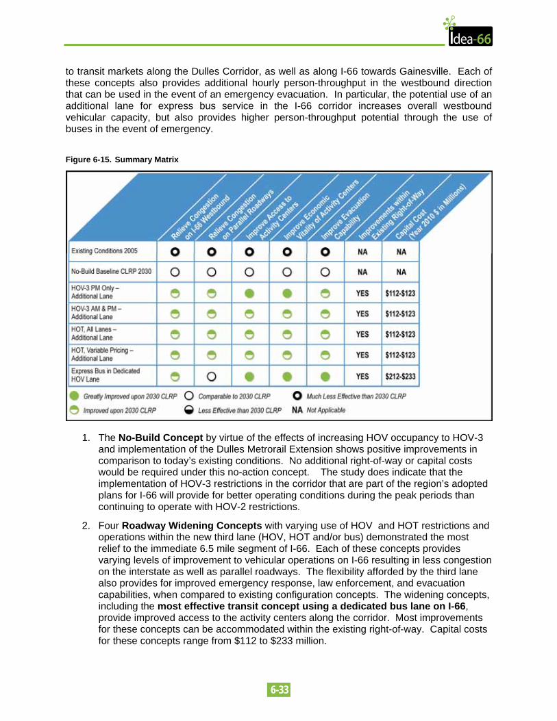
6-33
to transit markets along the Dulles Corridor, as well as along I-66 towards Gainesville. Each of these concepts also provides additional hourly person-throughput in the westbound direction that can be used in the event of an emergency evacuation. In particular, the potential use of an additional lane for express bus service in the I-66 corridor increases overall westbound vehicular capacity, but also provides higher person-throughput potential through the use of buses in the event of emergency.
Figure 6-15. Summary Matrix
1. The No-Build Concept by virtue of the effects of increasing HOV occupancy to HOV-3 and implementation of the Dulles Metrorail Extension shows positive improvements in comparison to today’s existing conditions. No additional right-of-way or capital costs would be required under this no-action concept. The study does indicate that the implementation of HOV-3 restrictions in the corridor that are part of the region’s adopted plans for I-66 will provide for better operating conditions during the peak periods than continuing to operate with HOV-2 restrictions.
2. Four Roadway Widening Concepts with varying use of HOV and HOT restrictions and operations within the new third lane (HOV, HOT and/or bus) demonstrated the most relief to the immediate 6.5 mile segment of I-66. Each of these concepts provides varying levels of improvement to vehicular operations on I-66 resulting in less congestion on the interstate as well as parallel roadways. The flexibility afforded by the third lane also provides for improved emergency response, law enforcement, and evacuation capabilities, when compared to existing configuration concepts. The widening concepts, including the most effective transit concept using a dedicated bus lane on I-66, provide improved access to the activity centers along the corridor. Most improvements for these concepts can be accommodated within the existing right-of-way. Capital costs for these concepts range from $112 to $233 million.
6-34
The preliminary concepts include increasing the inside shoulder width to 10-feet, adding a new travel lane, and increasing the outside shoulder width to 10-feet. In the case of the dedicated bus lane an additional 4-foot buffer is included to separate the dedicated bus lane from the two other lanes. These improvements result in an additional 16 or 20 feet of pavement over the existing design. For the majority of the corridor this additional pavement can be accommodated within the existing right-of-way. However there are a few locations where additional right-of-way would be needed. To avoid these impacts additional retaining walls and design exceptions would be needed. These design exceptions include using 11-foot lanes instead of the normal 12-foot lanes, and reducing or eliminating the 10-foot shoulders for short lengths.
The locations where these design exceptions would be needed include Spout Run, several undeveloped parcels between Spout Run Parkway and Lee Highway, at Westover Playground, privately owned land near the Patrick Henry Drive overpass, in the vicinity of the Ohio Street overpass and at the East Falls Church Metro Station. The dedicated bus lane would also require design exceptions along two more parcels in the common area just to the east of Spout Run and at an undeveloped parcel at the Route 29 overpass in Rosslyn. The undeveloped parcels involved with either concept were part of the original land acquisition for I-66 that have been returned to the county.
The base mapping used in designing the preliminary concepts was based on Fairfax and Arlington County GIS data and available aerial photography. The existing right-of-way boundaries were obtained from each locality’s GIS. A more detailed survey and property line investigation is recommended as part of the next phase of the project. Upon completing these investigations, the right-of-way impacts would be refined and there is the potential that impacts would be completely avoided or would be mitigated.
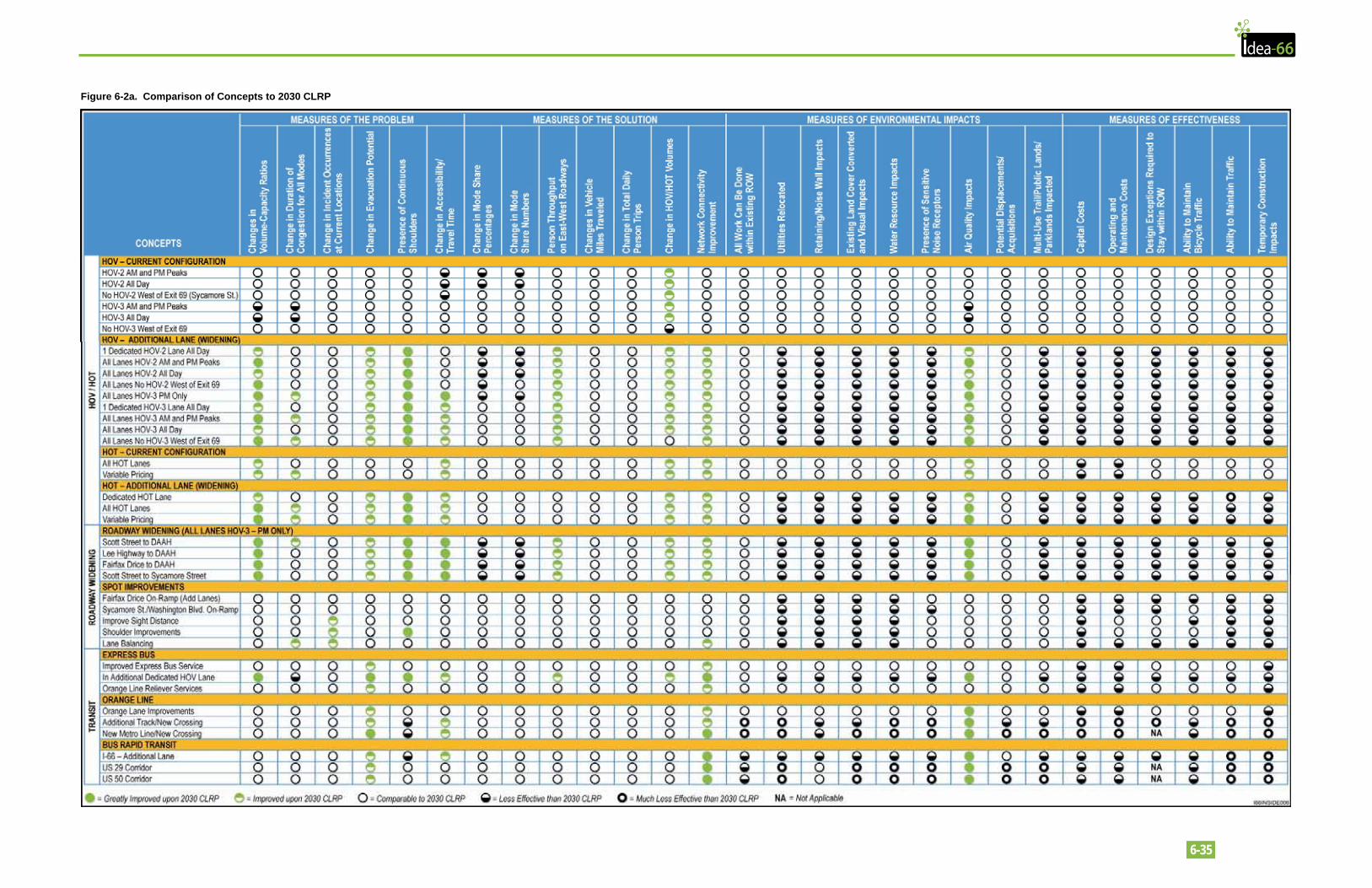
6-35
Figure 6-2a. Comparison of Concepts to 2030 CLRP
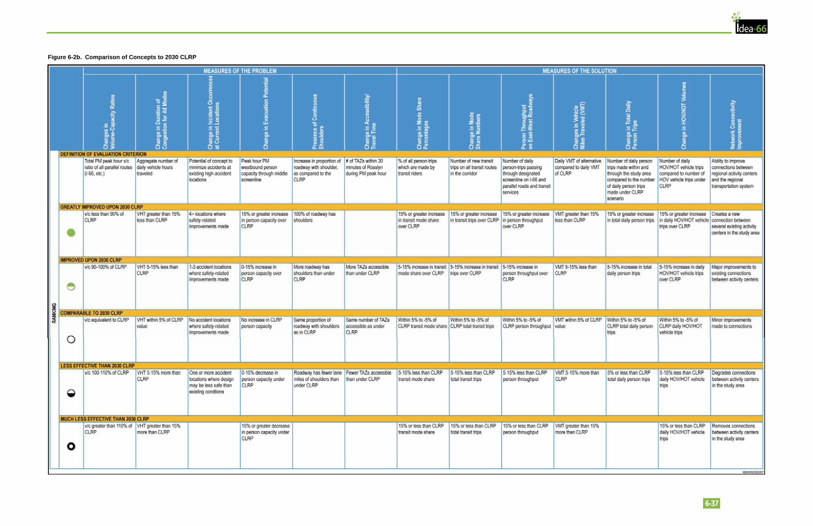
6-37
Figure 6-2b. Comparison of Concepts to 2030 CLRP
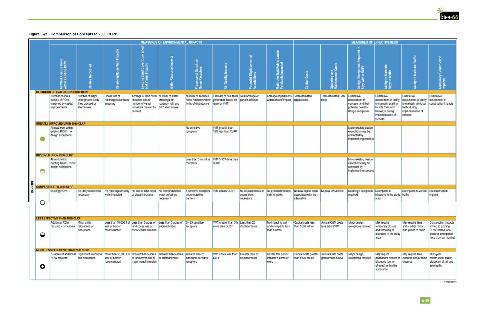
6-39
Figure 6-2c. Comparison of Concepts to 2030 CLRP