Embed Size (px)
Citation preview
SSU: Detailed Soil Survey of Royal Botanic Garden, Serbithang
Report No.: SS11 – Detailed Soil Survey Report of Royal Botanic Garden, Serbithang Page 1 of 27
Royal Government of Bhutan
Soil Survey Unit (SSU) National Soil Services Centre, Semtokha
Council for RNR Research for Bhutan (CoRRB) Ministry of Agriculture
TECHNICAL REPORT ON THE DETAILED SOIL SURVEY
OF ROYAL BOTANIC GARDEN, SERBITHANG
Report No. 11 (a)
March, 2000
SSU: Detailed Soil Survey of Royal Botanic Garden, Serbithang
Report No.: SS11 – Detailed Soil Survey Report of Royal Botanic Garden, Serbithang Page 2 of 27
CONTENTS
SUMMARY _______________________________________________________________ 4
ACKNOWLEDGEMENTS _____________________________________________________ 4
ABBREVIATIONS AND GLOSSARY _____________________________________________ 5
INTRODUCTION ___________________________________________________________ 7
1.1 Royal Botanic Garden, Serbithang ______________________________________ 7
1.2 Aims of the soil survey of the Royal Botanic Garden _______________________ 7
2. THE SURVEY AREA ____________________________________________________ 8
2.1 Location and extent _________________________________________________ 8
2.2 Climate ___________________________________________________________ 8
2.3 Geology and soil parent materials _______________________________________ 8
2.4 Topography and drainage _____________________________________________ 8
2.5 Land use and vegetation ______________________________________________ 9
Table 2.1 Climatic summary for Yusipang 1985 - 1988, 1990 - 1995 _____________________ 10
3. PREVIOUS SOILS INFORMATION ________________________________________ 11
4. METHODS __________________________________________________________ 12
4.1 Field ____________________________________________________________ 12
4.2 Mapping _________________________________________________________ 12
4.3 Laboratory _______________________________________________________ 13
5. SOIL CLASSIFICATION, CHARACTERISTICS, AND CORRELATION _______________ 14
5.1 Soil classification __________________________________________________ 14
Table 5.1 Summary of soil classes at Royal Botanic Garden, Serbithang ___________________ 14
5.2 Characteristics of soil classes at Royal Botanic Garden, Serbithang. ___________ 14
5.2.1 Very shallow hill soil (HVS) _________________________________________________ 14
5.2.2 Moderately shallow hill soil (HMS) ____________________________________________ 15
5.2.3 Deep stony hill soils (HD) ___________________________________________________ 15
5.2.4 Poorly drained hillside gley (HG) _____________________________________________ 15 Table 5.2 Ranges of chemical analyses, by soil classes RBGS. __________________________ 16
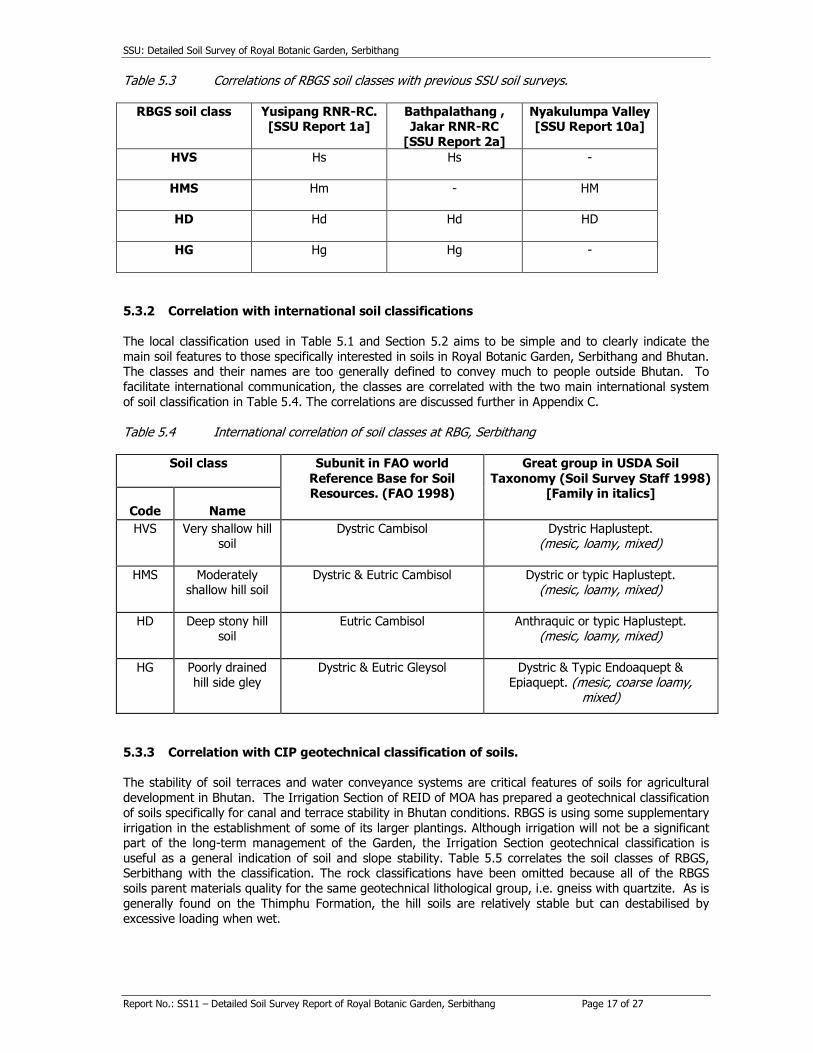
5.3 Soil correlation ____________________________________________________ 16 Table 5.3 Correlations of RBGS soil classes with previous SSU soil surveys. ________________ 17 5.3.2 Correlation with international soil classifications _________________________________ 17
Table 5.4 International correlation of soil classes at RBG, Serbithang _____________________ 17 5.3.3 Correlation with CIP geotechnical classification of soils. ___________________________ 17
Table 5.5 Geotechnical correlation of soils of Royal Botanic Garden ______________________ 18
6. SOIL DISTRIBUTION AND MAPPING _____________________________________ 19
6.1 Soil distribution. ___________________________________________________ 19
6.2 Soil mapping units. _________________________________________________ 19
Table 6.1 Soil mapping units at Royal Botanic Garden, Serbithang _______________________ 19 Table 6.2 Area of soil mapping units, Royal Botanic Garden, Serbithang __________________ 19
7. OVERVIEW AND IMPLICATIONS ________________________________________ 20
7.1 Overview of soils. __________________________________________________ 20
7.2 Implications of results ______________________________________________ 20
REFERENCES ____________________________________________________________ 21
APPENDIX A: SUMMARY OF METHODS OF SOIL ANALYSIS _____________________ 22 Table A.1 Summary of 1995 recommendations for interpretation of SPAL soil analyses _______ 23
SSU: Detailed Soil Survey of Royal Botanic Garden, Serbithang
Report No.: SS11 – Detailed Soil Survey Report of Royal Botanic Garden, Serbithang Page 3 of 27
APPENDIX B: SOIL PROFILE DESCRIPTIONS AND ANALYSES ___________________ 24 Table B.1 Summary of soil profiles _______________________________________________ 24
APPENDIX C: CORRELATION OF RBGS SOILS ________________________________ 25
C.I Soil classification and correlation in Bhutan ______________________________ 25
C.2 General criteria ____________________________________________________ 25 C.2.1 Soil moisture regime ______________________________________________________ 25
C.2.2 Soil temperature regime ___________________________________________________ 25 C.2.3 Mineralogy class __________________________________________________________ 25
C.2.4 Particle size class. ________________________________________________________ 25
C.3 Correlation of RBGS soils ____________________________________________ 25
C.3.1 Very shallow hill soil _______________________________________________________ 25
C.3.2 Moderately shallow hill soil _________________________________________________ 26 C.3.3 Deep stony hill soils _______________________________________________________ 26
C.3.4 Poorly drained hill side gley soil ______________________________________________ 26
APPENDIX D: Soil Survey Unit ___________________________________________ 27
D.1 SSU ___________________________________________________________ 27
Table D.1 SSU main surveys and reports ___________________________________________ 27
SSU: Detailed Soil Survey of Royal Botanic Garden, Serbithang
Report No.: SS11 – Detailed Soil Survey Report of Royal Botanic Garden, Serbithang Page 4 of 27
SUMMARY The fieldwork for a detailed soil survey for the Royal Botanic Garden at Serbithang (RBGS) was carried
out from 5th to 29th October 1999 to provide soil information on the recently established Royal Botanic Garden.
The survey area covers 11.6 ha (about 28.6 acres) and is located in Serbithang above the Thimphu -
Phuentsholing highway. It is about 2 kilometers by road, south of the Babesa road junction. It is in Chang
gewog under Thimphu Dzongkhag, and within the Western Agricultural Region. The survey area comprises the crest and side slopes of the lower section of a spur. It has more or less north-facing slopes. The survey area was an improved pastureland before the institution of RBGS. Since
the Royal Botanic Garden was only set up recently, the infrastructure and planting work are still in progress. However a few specimen plants have been planted, and office and Garden centre are on the
verge of completion. In course of time the garden will be planted with up to 500 species of plants and
will be the first in the country. The National Herbarium will also be built on the site.
The deep stony soils are the most extensive soils of the survey area. They are located on the side slopes and lower concavities of the spur. They have yellowish or greyish brown topsoils with bright coloured
subsoils of reddish yellow or strong brown. The texture varies from sandy loam to sandy clay but most
commonly is sandy clay loam. The soils are deep (>100 cm to weathered rock) but contain many hard, angular quartzite stones. There are also some very shallow (< 60 ca 50 cm to bedrock) and moderately
shallow (< 100 cm to weathered rock) soils which are morphologically similar to the deep stony soil, as
they are all formed from same parent material. They are mostly found on the upper slope and crest of
the spur. The fourth soil class consists of poorly drained gleys in wet areas. They have many faint to
distinct mottles in the first two horizons, and are grey and wet beneath. Their depth, texture and the stone content are similar to those of the deep stony soils.
The soils are mapped into three soil mapping units, depending on their depth and natural drainage
status. The deep stony hill soils are mapped as unit HD, and very shallow and moderately shallow hill soils are mapped as the complex HX. The poorly drained hillside gleys are mapped as HG.
ACKNOWLEDGEMENTS The fieldwork for this survey was done by Tshering Dorji and Tsheten Dorji under the guidance of Dr. Ian C. Baillie, Soil Survey Specialist. The report was drafted by them and compiled by Ms Pema Wangmo.
The soil analyses were done by SPAL. The base maps were supplied by Irrigation Section of REID. The interim map was prepared by Tshering Dorji and Tsheten Dorji of SSU. The final GIS map will eventually
be redrawn by the Geographic Information System Unit in the Land Use and Statistics Section of the
Planning and Policy Division of the Ministry of Agriculture in Thimphu.
SSU: Detailed Soil Survey of Royal Botanic Garden, Serbithang
Report No.: SS11 – Detailed Soil Survey Report of Royal Botanic Garden, Serbithang Page 5 of 27
ABBREVIATIONS AND GLOSSARY
(Simple metric units and chemical element symbols not included)
AAS Atomic absorption spectrophotometery
AHT Agrar - and HydrotechniK, GmbH, (Germany).
AmoAc Ammonium acetate (extractant for exchangeable cations and for measuring CEC)
Av Available amsl Above mean seal level
BS% Base saturation percentage
C Clay CEC Cation exchange capacity
Chhu Stream or river
CL Clay loam
Colluvium Local hillwash, moved by surface erosion or slow non-glacial creep processes. CoRRB Council for RNR Research of Bhutan
Danida Danish International Development Assistance
Dzongkhag Administrative district EC Electrical conductivity
Exch Exchangeable (for cations)
Extr Extractable (for soil nutrients)
FAO Food and Agriculture Organisation of United Nations
fe fine earth (particle size < 2mm) Geog Block or subdistrict, administrative subdivision of Dzongkhag.
GIS Geographical information system Gley Soil that is permanently wet, poorly aerated and has predominantly
greyish colours, due to reduction of free iron to ferrous valency state.
May have local oxidising conditions giving rust - coloured mottles, especially around root
channels
GPS Global positioning system ha Hectare
HCl Hydrochloric acid L Loam
LUPP Land Use Planning Project, in PPD
LUSS Land Use and Statistics Section, in PPD
me% miliiequivalents per 100 g fine earth
MoA Ministry of Agriculture mS/cm milliSiemens per centimetre (unit of electrical conductivity)
MTI Ministry of Trade and Industry
NH4OAC Ammonium acetate OC Organic carbon
P Phosphate pH Measure of acidity - alkalinity
PM Parent material PPD Planning and Policy Division, MoA
ppm Parts per million
PSC Particle size class (Soil Taxonomy) RBGS Royal Botanic Garden, Serbithang
RGOB Royal Government of Bhutan RNR Renewable natural resources - agriculture, animal husbandry and
forestry.
RNR-RC RNR Research Centre S Sand
Saprolite Soft weathered rock Si Silt
Sk Skeletal (high stone content) SMU Soil mapping unit
Solum True soil with no remaining rock structures
SSU: Detailed Soil Survey of Royal Botanic Garden, Serbithang
Report No.: SS11 – Detailed Soil Survey Report of Royal Botanic Garden, Serbithang Page 6 of 27
SPAL Soils and Plant Analysis Laboratory, Semtokha.
SSU Soil Survey Unit ST Soil Taxonomy (US system of soil classification)
TE Trace elements
TEB Total exchangeable bases (= exchangeable Ca + Mg + Na + K)
USDA United States Department of Agriculture
v/v % by volume WR Weathered rock
WRB World Reference Base for Soil Resources (ISRIC development of FAO system of soil classification)
w/w % by weight
X Exchangeable (for cation)
Z,Zi Silt
SSU: Detailed Soil Survey of Royal Botanic Garden, Serbithang
Report No.: SS11 – Detailed Soil Survey Report of Royal Botanic Garden, Serbithang Page 7 of 27
INTRODUCTION
1.1 Royal Botanic Garden, Serbithang The Royal Botanic Garden at Serbithang (RBGS) was inaugurated by Her Majesty, Ashi Sangay Choden
Wangchuck on May 26, 1999 to mark the 25th coronation Anniversary of His Majesty, The Fourth Druk
Gyalpo, Jigme Singye Wangchuck. (Kuensel, 29.5.1999)
Prior to the establishment of RBGS, the area was pastureland, with patches of improved pasture, with sparse blue pine, oak and poplar trees.
The long term objectives of RBG are:
• Advance conservation of Bhutan's rich floristic diversity
• Educate the general public to know and understand plants
• Promote community awareness of nature and the environment, and the need for its conservation
• Provide social and leisure amenities.
1.2 Aims of the soil survey of the Royal Botanic Garden
The detailed soil survey was undertaken with objectives of:
Providing the staff and management of Royal Botanic Garden with detailed information on the nature and
distribution of soils of the site, as an aid in its establishment and management.
Providing SSU with further data for the development of a national soil classification, and for national and
regional soil maps.
SSU: Detailed Soil Survey of Royal Botanic Garden, Serbithang
Report No.: SS11 – Detailed Soil Survey Report of Royal Botanic Garden, Serbithang Page 8 of 27
2. THE SURVEY AREA
2.1 Location and extent The Royal Botanic Garden is located at Serbithang in Chang geog in Thimphu Dzongkhag above Thimphu
- Phuntsholing highway. It is about 2 kilometers by road and about 1 km in a straight line south of the Babesa road junction. It is located at 27o 25.4’ N and 89o 39.0’ E, within the Western Agricultural Region.
It covers about 11.6 ha (28.6 acres).
2.2 Climate There are no meteorological stations or data for RBGS. Climatic data from Yusipang RNR-RC has been
taken as nearly equivalent in altitude (ca 2600 m), although Yusipang is on a south-facing slope.
The RBGS spans an altitude range of 2450 - 2560 m a.s.l, and is in the cool temperate climatic zone, with
blue pine, Quercus spp. and Populus ciliata forest as the dominant natural vegetation. The site has a more or less northerly aspect. The local microclimate therefore tends to be relatively cool, moist and
shaded for its altitude.
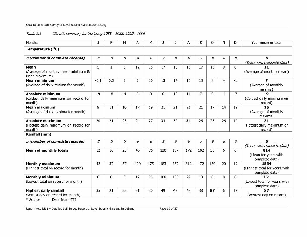
Table 2.1 summarises the main features of the climate of the Yusipang RNR-RC for the period 1985-
1995. At Yusipang the mean minimum temperatures drop to about -10 C in December – January, and rise to about 150 C in August. The mean maximum rises from about 90 C in January to 210 C during June –
September. The absolute maximum recorded is 310 C on days in June and August and the absolute minimum recorded is -90 C in January. The mean annual rainfall is 814 mm, of which 667 mm (82%) falls
in the monsoon months of May – September. Humidities and cloud cover are high during the monsoon,
but clear skies and dry air predominate during the rest of the year (data from MTI).
2.3 Geology and soil parent materials Jangpangi (1968) maps the site as being as close to the boundary between quartzite and mica schist and
more highly metamorphosed gneisses with mica schist. Gansser (1983) maps the area as the Paro Formation, which is moderately - highly metamorphosed and has a high proportion of schists.
The most recent geological description of the Thimphu area indicates that the area is wholly underlain by
the Thimphu Gneiss formation (Bhargava 1995). This is a highly metamorphosed rock, with muscovite
and biotite micas, plagioclase feldspars, and quartz as the main minerals. The rocks were formed by the
folding and shearing that occurred in the thrusting from the north during the Himalayan orogeny.
The soils on the ridge are residual and have very shallow sola (<20 cm deep) overlying hard quartzite.
The quartzite is inter-bedded with highly weathered biotite gneiss, which liberates considerable quantities of ferric iron compounds, on weathering, and gives bright red-orange-yellow soil colours. It is possible
that the weathering was more intense during periods in the Pleistocene and/or Holocene when the
climate of the area was warmer and more humid than now. On the lower side slope of ridge, the quartzite is underlain by schists. Some of them are also highly weathered giving strong brown soil
colours. However others are not so weathered and are more dark greyish brown. The colluvial deposits on the gentler, slightly concave lower slopes are thick in places but are mostly less
than 2 m deep. These deposits are underlain by Thimphu gneiss, which is highly weathered.
2.4 Topography and drainage The RBGS site is located on the middle section of a quartzite spur running down from SSE to NNW
towards the valley of Thim Chhu. The upper part of the Garden is on the crest and the rest consists of lower and side slopes. The Garden stretches from about 2450 m to 2560 m a.s.l. in altitude, giving a total
relief of about 110 m. The slopes are predominantly straight (= rectilinear) with gradients in the range 10 - 50 %. More gently graded sections occur on the crest and convex upper slopes of the ridge, and in the
concavities down slope.
SSU: Detailed Soil Survey of Royal Botanic Garden, Serbithang
Report No.: SS11 – Detailed Soil Survey Report of Royal Botanic Garden, Serbithang Page 9 of 27
The drainage is good on the ridge crest and side slopes, and on the lower slopes. However there are a
few small marshy areas. Some of these are not natural and are created by the seepage from channels and leakage from water pipes.
2.5 Land use and vegetation The RBGS is on a north-facing slope. Before clearance for pasture the natural vegetation was probably mixed broadleaf and blue pine forest. It was then cleared and converted to a pasture. A few remnant
blue pines and poplar trees are still found. Some areas of the pasture remain where it is not cleared for
RBGS planting. The common herbaceous species in the pasture are Cosmos bipinnatus, Artemisia vulgaris, Gnaphaline affine, Chenapodium album and Rumex nepalensis. Unlike other north facing slopes, the current vegetation in the unplanted areas is poor, especially on the
ridge and side slopes, with few blue pines, Quercus spp. and some Populus ciliata. This is partly due to a very shallow soil overlying a hard quartzite but may be also because of over-cutting of the original
woodland.
RBGS have planted a wide range of ecologically suitable species of plants. However since it is in its early
stage, the planting programme has not been completed for the whole area. Species already planted include Juniperus recurva, Pieris furmosa, Astilble rivularis, Rheum australe, Aconitum laciniatum, Iris clarkei, Pinus wallichaina, Cupresses corneyana, Pinus roxburghii, Enkianthus deflexus, Abies densa, Benthamidia capitata, Taxus baccata, Podophyllum hexandrum, Podophyllum emodi, Zanthoxylum bungeanum, Tsuga dumosa, Cedrus deodara, Exbucklandia populnea, Quercus lanata, Edgeworthia gardneri, Musa spp., Rhododendron setosum, Rhododendron arboreum, Rhododendron anthopogon, Rosa brunonii, Rhododendron griffithianum, Rhododendron dalhousiae etc.
SSU: Detailed Soil Survey of Royal Botanic Garden, Serbithang
Report No.: SS11 – Detailed Soil Survey Report of Royal Botanic Garden, Serbithang Page 10 of 27
Table 2.1 Climatic summary for Yusipang 1985 - 1988, 1990 - 1995
Months J F M A M J J A S O N D Year mean or total
Temperature ( 0C)
n (number of complete records) 8 8 8 8 8 9 8 9 9 9 8 8 8 (Years with complete data)
Mean
(Average of monthly mean minimum &
Mean maximum)
5 1 6 12 15 17 18 18 17 13 9 6 11
(Average of monthly mean)
Mean minimum
(Average of daily minima for month)
-0.1 0.3 3 7 10 13 14 15 13 8 4 -1 7
(Average of monthly minima)
Absolute minimum
(coldest daily minimum on record for month)
-9 -8 -4 0 0 6 10 11 7 0 -4 -7 -9
(Coldest daily minimum on record)
Mean maximum
(Average of daily maxima for month)
9 11 10 17 19 21 21 21 21 17 14 12 15
(Average of monthly maxima)
Absolute maximum
(Hottest daily maximum on record for month)
20 21 23 24 27 31 30 31 26 26 26 19 31
(Hottest daily maximum on record)
Rainfall (mm)
n (number of complete records) 8 8 8 8 8 9 8 9 9 9 8 8 8 (Years with complete data)
Mean of monthly totals
12 16 25 46 76 130 187 172 102 36 6 6 814
(Mean for years with
complete data)
Monthly maximum
(Highest total on record for month)
42 37 57 100 175 183 267 312 172 150 20 19 1534
(Highest total for years with
complete data)
Monthly minimum
(Lowest total on record for month)
0 0 0 12 23 108 103 92 13 0 0 0 351
(Lowest total for years with
complete data)
Highest daily rainfall
Wettest day on record for month)
35 21 25 21 30 49 42 48 38 87 6 12 87
(Wettest day on record)
* Source: Data from MTI
SSU: Detailed Soil Survey of Royal Botanic Garden, Serbithang
Report No.: SS11 – Detailed Soil Survey Report of Royal Botanic Garden, Serbithang Page 11 of 27
3. PREVIOUS SOILS INFORMATION
As far as is known, there have been no previous soil surveys in the area of the Royal Botanic Garden.
However there are two nearby sites where soil surveys have been done, i.e. Renewable Natural Resources Research Centre (RNR-RC) at Yusipang and Gidakom.
A detailed soil survey of RNR-RC, Yusipang (SSU 1998) was carried out during June - September 1997.
The Centre lies about 10 km to the northeast of RBGS. It occupies the sloping floor of a side valley of Ola
Rong Chhu and the lower slopes of the hills to each side. The soils are formed in residual and colluvial materials on the hills, and in the fan alluvium of the valley floor. All of the soil parent materials are
derived from the Thimphu gneiss. The soils of the Centre are subdivided into three main geomorphic-parent material groups, i.e. residual and colluvial soils of hill slopes, colluvial/slump soils of footslopes,
and depositional soils of the valley floor. The soils of the area span a fairly narrow textural range, with sandy loams and sandy clay loams predominant. The soils are moderately acid and have generally low
contents of available N and P.
The pilot study area at Gidakom (LUPP 1995) is the closest, both in distance and in altitudinal and
ecological equivalence, of the land resource evaluations undertaken by the Land Use Planning Project. The soils at Gidakom are influenced by substantial outcrops of limestone, and many of them are finer
textured, redder, and have higher pH and exchangeable base status than those of RBGS.
SSU: Detailed Soil Survey of Royal Botanic Garden, Serbithang
Report No.: SS11 – Detailed Soil Survey Report of Royal Botanic Garden, Serbithang Page 12 of 27
4. METHODS
4.1 Field The fieldwork for this survey was done in October 1999. The net time taken for the fieldwork was about
one week.
The soils were examined on a routine basis at 48 sites, mainly with a 1.2 m Edelman auger, fitted with a
7 cm combination head where possible, but switching to a 7cm stony soil head where necessary. Duplicate augerings were done at 13 of the sites, where the first attempt to auger was stopped by stones at less than 50 cm. A few routine examinations were done in road cuttings, cut back at least 15 cm to expose fresh soil. Most of the routine observations were sited at 50 m intervals along compass traverses,
mostly aligned up- and downslope. The locations of the start points, some intermediate way points, and
the ends of the traverses were checked with a Magellan GPS. For routine soil observations the following site data were collected: Location, GPS; general topography and site position; the angle (in %), aspect, length and form of the slope; solid geology and drift parent material; general land use and current crops/vegetation; irrigation
type; artificial land shaping features; fertiliser use, if present and if known; site drainage and surface
stones.
The soils were described according to their natural layering (horizons), in the upper one metre, and not at fixed depths. The following data were collected for each horizon:
Munsell colour of matrix (in field moisture condition); number, size, contrast and colour of mottles; field texture; number, size and type of stones; moisture condition; and consistence on the auger.
The soils were described in more detail at nine sites. Seven of the detailed descriptions were done in
freshly cleaned-back road cuttings and the other two in purpose-dug profile pits.
The site data were the same as for the routine sites, with the addition of a more detailed description of
surface features, including:
Microrelief, rock outcrops; stones, litter, cracks, faunal activity, and capping.
Note that the altitudes for individual profiles in Appendix are altimeter readings and are taken from the
map contours. The soils were described by horizons according to international conventions (FAO 1990). The data collected for each horizon were the same as in the routine descriptions, with the addition of:
Strength, size and type of soil structure; number and size of pores, presence, strength and continuity of
cutans (shiny coatings on surfaces of soil structural units); consistence in situ and in hand; number size
and type of roots; reaction to HCl (to test for presence of free carbonate minerals); concretions of iron,
manganese or other secondary formations; presence and effects of animals (wormcasts etc.); any other
features (e.g. charcoal); clarity and shape of lower boundaries.
23 main horizons of all profiles described in detail were sampled for analysis.
4.2 Mapping The base map for the soil survey of Royal Botanic Garden was provided by the Irrigation Section of the
Research Extension and Irrigation Division, Ministry of Agriculture. The map is at a scale of 1:1000. It shows all the infrastructures. However they have mapped the area in two separate sheets. This created
some inconvenience for us to marry these two sheets to produce the final soil map on one sheet.
Otherwise it was an excellent base map.
SSU: Detailed Soil Survey of Royal Botanic Garden, Serbithang
Report No.: SS11 – Detailed Soil Survey Report of Royal Botanic Garden, Serbithang Page 13 of 27
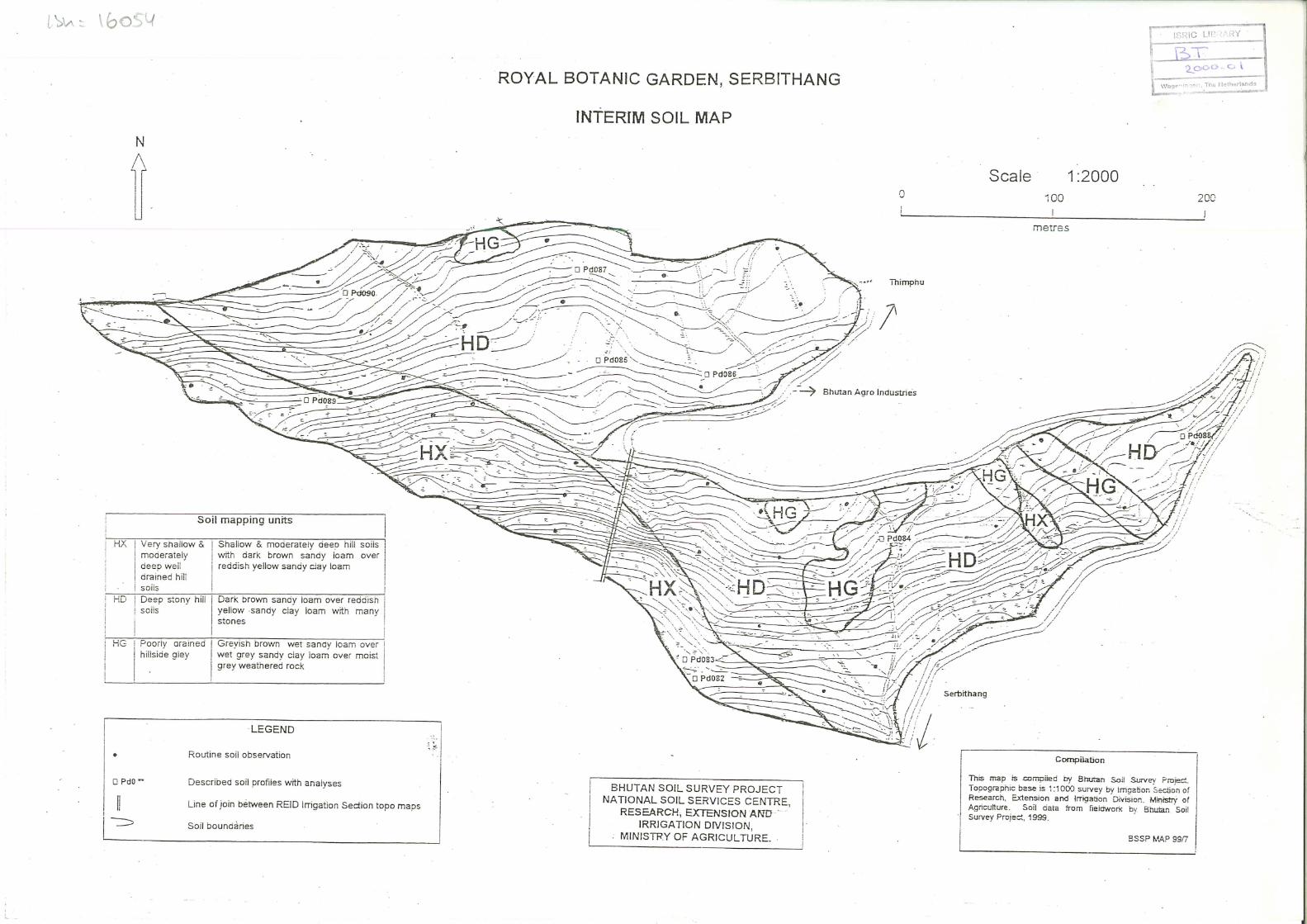
The attached interim map is at the scale of approximately 1:2000. It was produced by photocopier
reduction. There were problems in joining the two separate sheets, and the line of junction is shown. The map will be digitised into the GIS at a later stage.
4.3 Laboratory The 23 soil samples collected from the main horizons of the nine detailed profiles were analysed by the Soil and Plant Analytical Laboratory (SPAL) of the Research, Extension and Irrigation Division (REID) of the Ministry of Agriculture at Semtokha. The methods of analysis used by SPAL are summarised in
Appendix A.
The only chemical methodological points that need to be mentioned here concern the measurement of cation exchange capacity (CEC) and calculation of base saturation (BS%). CEC can be measured by
saturating the soil with ammonium cations, and measuring them. This is referred to as CEC (NH4OAC). An alternative is to estimate CEC by summing the exchangeable bases (Ca + Mg + K + Na = TEB) and
the extractable aluminium and hydrogen. This is known as the 'effective cation exchange capacity'
(ECEC). SPAL does not measure extractable Al and H in soils with pH (water) greater than 5.5. As none
of our RBGS samples are that acid, there are no determinations for extractable Al or H. In such cases the
ECEC is identical with the TEB. It is therefore not very useful, and has not been given in this report.
Base saturation is the quotient TEB/CEC. If the TEB and the ECEC are identical (as is the case where
there is no extractable Al or H), the 'effective base saturation' (EBS %) is automatically 100 %. These values add nothing, and have not been given in this report. The base saturations in the following soil
class descriptions and in the profile data in Appendix B refer to TEB/CEC (NH4OAC).

SSU: Detailed Soil Survey of Royal Botanic Garden, Serbithang
Report No.: SS11 – Detailed Soil Survey Report of Royal Botanic Garden, Serbithang Page 14 of 27
5. SOIL CLASSIFICATION, CHARACTERISTICS, AND CORRELATION
5.1 Soil classification The soils of the Royal Botanic Garden are all located on a spur and its side slopes. The soils have narrow
range of colours and textures. So these features are not used to define the soil classes. The soils are classified into four main classes on depth and natural drainage. The soils on the crest of the spur are
mostly shallow and are subdivided into very shallow and moderately shallow classes. The side slope and
the lower concave slopes mainly have deep stony soils. There are patches of marshy soils on side slopes of the spur, which are classified as hill gley soils. The classes are summarised in Table 5.1. In the
descriptions of each soil class in section 5.2, the main features of the natural profile are described. More details of the morphologies for individual profiles are given in Appendix B.
Table 5.2 summarises the main chemical characteristics of the soil classes, as determined for the profile samples collected during the survey. The detailed analyses for individual profiles are given in Appendix B.
Table 5.1 Summary of soil classes at Royal Botanic Garden, Serbithang
Soil Class Brief description Profiles & analyses
(Appendix B) Code Name
HVS Very shallow hill soil
Dark brown sandy loam topsoil; over reddish yellow or strong brown sandy loam - sandy clay; over hard
quartzite ca 50 cm of surface; mostly on spur crest
Pd089
HMS
Moderately shallow hill
soil
Dark brown sandy loam topsoil; over reddish yellow or strong brown sandy loam - sandy clay; over reddish soft
weathered or hard gneiss within < 100cm of surface; mostly on upper slopes & convexities
Pd082
Pd083
HD Deep stony hill
soil
Dark brown sandy loam topsoil; over reddish yellow or
strong brown stony sandy loam - sandy clay with no
weathered or hard rock within 100 cm of surface;
mostly in concavities
Pd085
Pd086
Pd087
Pd088 Pd090
HG Poorly drained
hillside gley
Dark or greyish brown moist - wet sandy loam; over wet
grey variable loamy sand - sandy clay; over moist grey weathered gneiss; hillside depressions and drainage
lines, channel & pipe leakage areas
Pd084
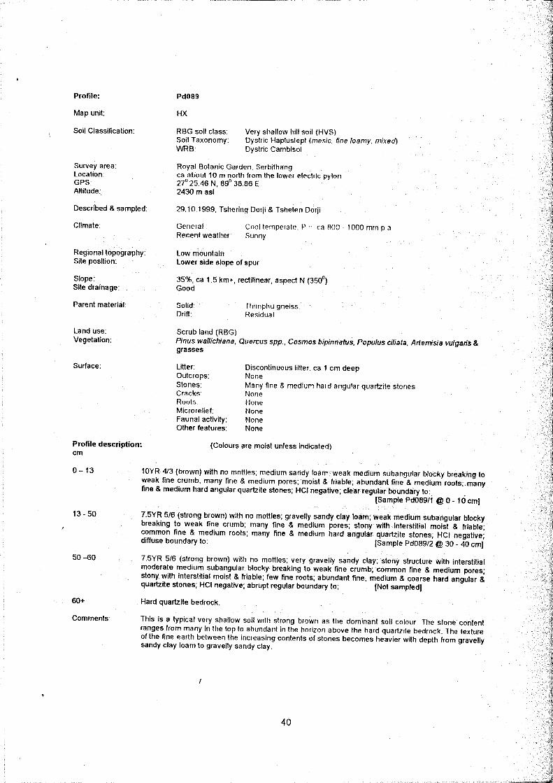
5.2 Characteristics of soil classes at Royal Botanic Garden, Serbithang. 5.2.1 Very shallow hill soil (HVS)
These soils are found mostly on the spur crest and few patches on the side slope below the water tank.
There is one fully described and sampled profile (see Pd089 in the Appendix B).
By definition the sola of these soils are ca 50 cm deep to bedrock. The topsoil is dark greyish or yellowish
brown, sandy loam in texture, with weak to moderate medium subangular blocky breaking to weak fine crumb structure, and good porosity. The topsoils are stony, with quartzite dominant. The subsoil is
brightly coloured with a yellowish red or strong brown matrix, which tends to get slightly redder with depth. It is very stony with abundant quartzite stones. The fine earth textures have a fairly narrow range,
from sandy loam to sandy clay and silty clay, with sandy clay loam predominant. The solum (true soil) is
underlain directly by hard quartzite bedrock.
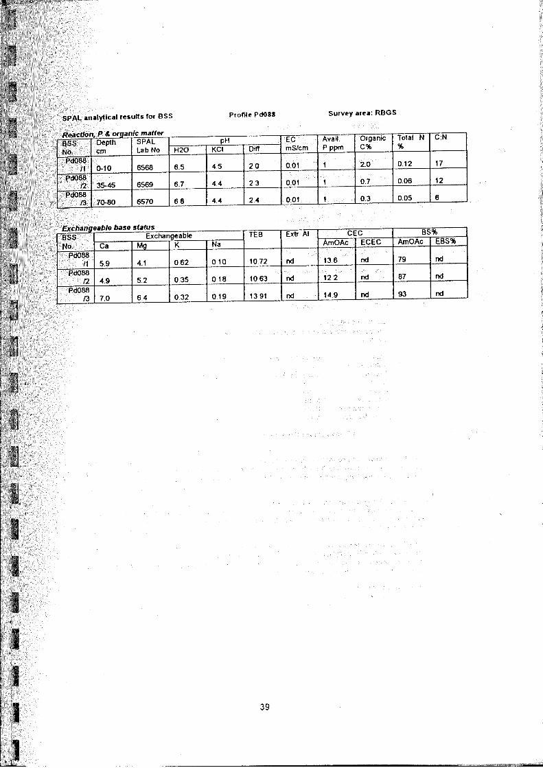
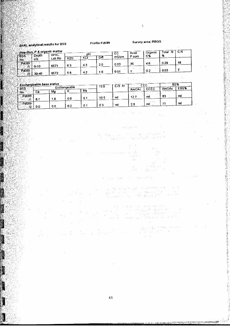
The topsoil of this profile (Pd089) has high organic carbon (4.6 %) and moderate total nitrogen (0.29 %) with moderate C:N ratio (16). Both the topsoil and subsoil are slightly acid (pH 6.3 - 5.8). The available P
in the topsoil is high (35 ppm). The TEB varies from moderate (11 me %) in the topsoil to very low (0.3
me %) in the subsoil. The BS% is very high (83 %) in the topsoil but it is very low (11 %) in the subsoil.
The soil has moderate to low exchangeable and available K.
SSU: Detailed Soil Survey of Royal Botanic Garden, Serbithang
Report No.: SS11 – Detailed Soil Survey Report of Royal Botanic Garden, Serbithang Page 15 of 27
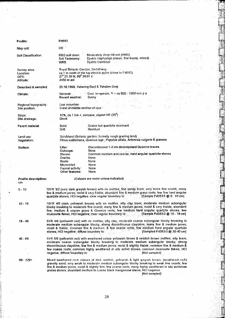
5.2.2 Moderately shallow hill soil (HMS)
These soils are found mostly on the spur crest and few patches on the upper slope. There are two fully
described and sampled profiles (see Pd082 and Pd083 in the Appendix B).
By definition the sola of these soils are between 50 cm and 100 cm deep to weathered rock. The sola of
the very shallow and moderately shallow soils are morphologically similar. The classes differ mainly in the nature of the underlying parent material. The topsoil is moderately dark greyish or yellowish brown,
sandy loam in texture, with weak to moderate medium subangular blocky breaking to weak fine crumb structure, and good porosity. It overlies brightly coloured subsoil with a yellowish red or strong brown
matrix, which tends to get a slightly redder with depth. Subsoil textures have a fairly narrow range from
sandy loam to sandy clay and silty clay, with sandy clay loam predominant.
The solum (true soil) is underlain by highly weathered gneiss, which overlies hard quartzite. The subsoil is highly coloured by free iron compounds and biotite released by weathered gneiss and may be redder
or brighter than the overlying soil. Unlike the hard quartzite underlying the very shallow soils, the
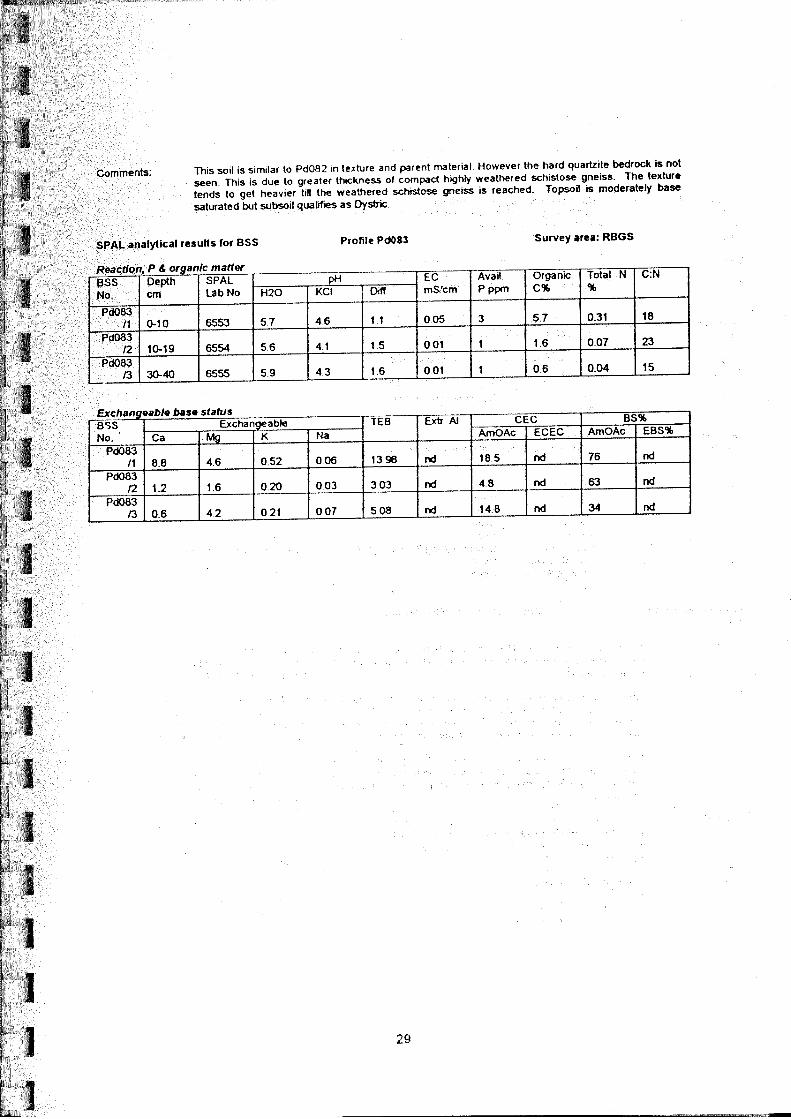
weathered gneiss is penetrable by roots and water. The topsoils of these profiles (Pd082 & Pd083) have variable contents of organic matter, with Organic carbon ranging from low to very high (1.5 - 5.7 %) and total nitrogen ranging from very low to moderate
(0.06 - 0.3 %). C:N ratios are moderate to poor (18 - 25). All of the topsoil and subsoil samples are
slightly acid (pH 5.4 - 6.0). The available P in the topsoils of these profiles is very low (1 - 3 ppm). The TEB varies from very low to moderate (2 - 14 me %) in the topsoils and from very low to moderate (3 - 7
me %) in the subsoils. The BS% in these profiles varies from very low to high (30 - 76 %) in the topsoils and from low to moderate (39 - 63 %) in the subsoils.
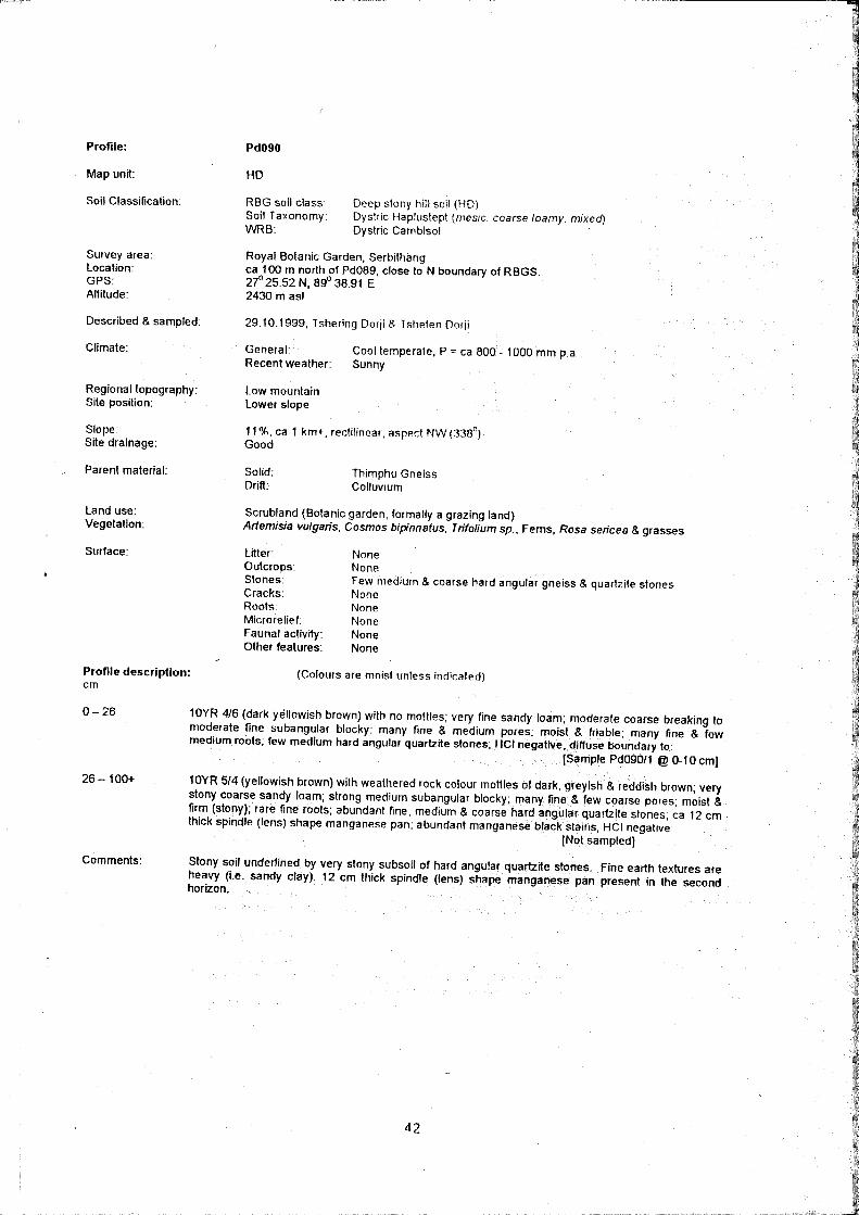
5.2.3 Deep stony hill soils (HD)
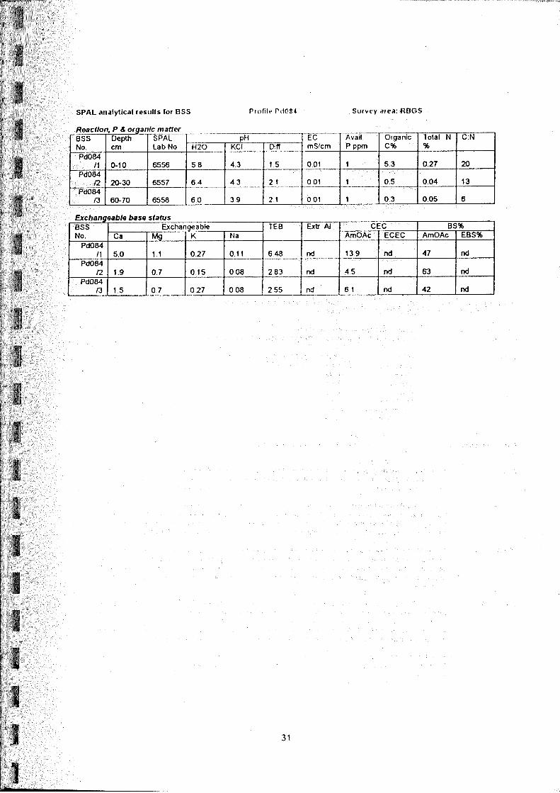
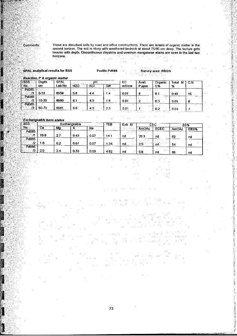
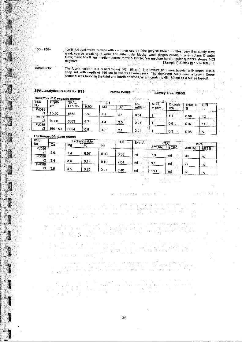
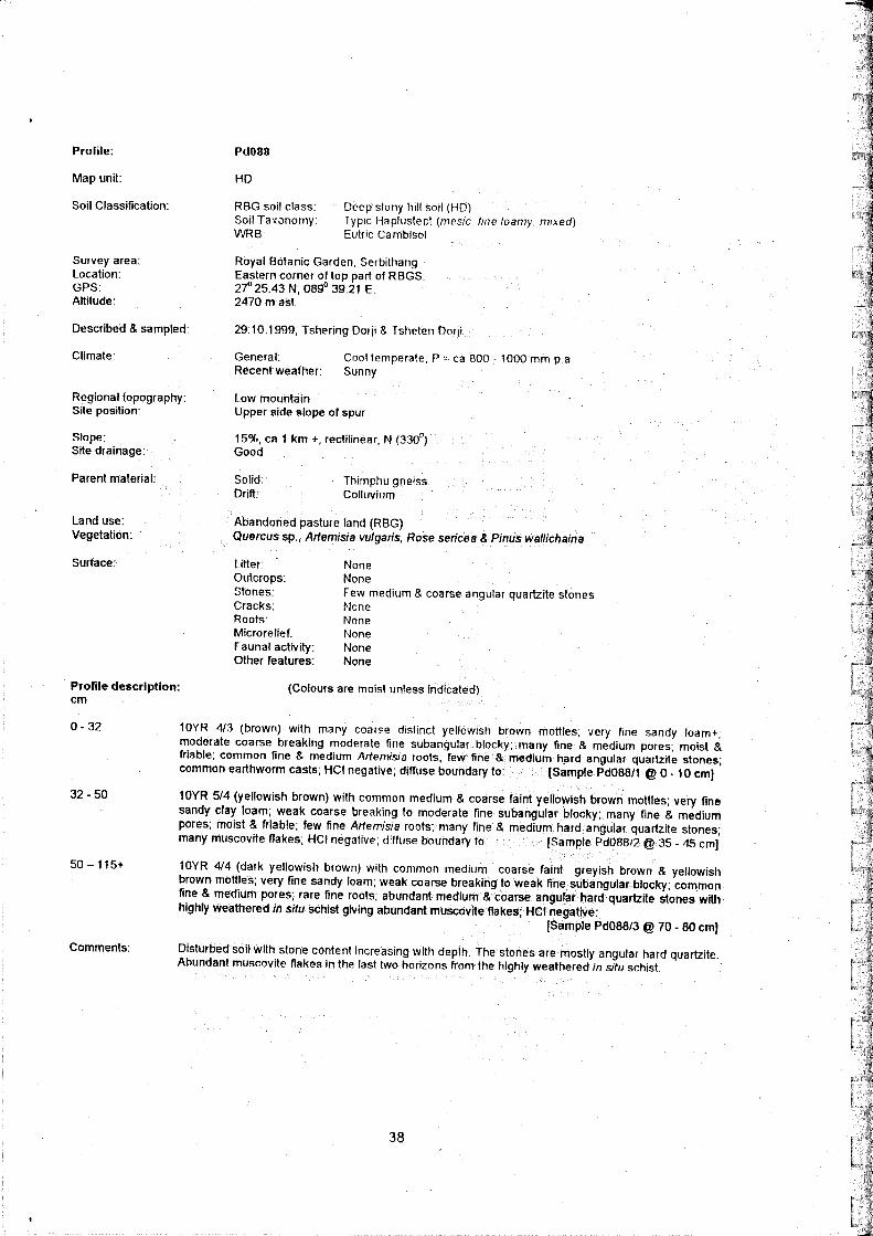
These soils are the most extensive soils of the Garden. They are found on the side slope of the spur and lower concave part of the area. There are five fully described and sampled profiles (see Pd085, Pd086,
Pd087, Pd088 & Pd090 in the Appendix B).
By definition the sola of these soils are greater than 100 cm deep to weathered rock but are very stony.
They are similar to the shallow and moderately shallow hill soils in colour, texture and structures as they lie in the slopes of the same spur and are derived from the same rock types. They differ in that the colluvial parent material is deeper, and has been well mixed with stones. The general profile consists of dark greyish or yellowish brown, heavy textured, crumb or blocky - structured topsoil over yellowish brown or strong brown, blocky subsoil. Both topsoil and subsoil textures are in the sandy loam – sandy clay range, with sandy loam and sandy clay loam predominant. Stone contents in the subsoil vary from rare to many. The stones vary in hardness and types from mainly hard quartz to softer fragments of gneiss.
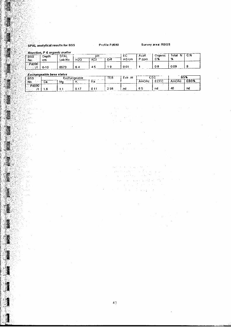
The topsoils of the five sampled profiles have low to very high (0.8 - 6.1%) organic carbon. The total
nitrogen contents in the topsoils vary from very low to moderate (0.09 - 0.4 %). The C:N ratios are very
low to moderate (9 - 15). Both the topsoils and subsoils of these profiles have slightly acid to neutral (pH 5.8 - 6.7). The available P in the topsoil of these profiles is very low to moderate (1- 12 ppm). The TEB
varies from very low to moderate (3 - 14 me %) in the topsoil and low to moderate (5 - 11 me %) in the subsoil of these profiles. The BS% of these profiles is low to high (46 - 79 %) in the topsoils and is
moderate to very high (52 - 87 %) in the subsoil. 5.2.4 Poorly drained hillside gley (HG)
These soils are not extensive. They are found in small patches on the side slope of the spur. Although the
slope is generally rectilinear, there are some pockets or concavities where water accumulates naturally. There are also patches where the water has leaked or overflowed from water tanks or channels and has
accumulated to create small marshy areas. There is one fully described and sampled profile (see Pd084 in
the Appendix B)
These soils are wet for long periods, and are formed in largely anaerobic conditions. This affects their morphology in two main ways:
SSU: Detailed Soil Survey of Royal Botanic Garden, Serbithang
Report No.: SS11 – Detailed Soil Survey Report of Royal Botanic Garden, Serbithang Page 16 of 27
Free iron compounds are in their anaerobic reduced forms, which give mainly grey matrix colours to the
mineral subsoil and weathered rock horizons. Patches where aeration is better, such as around parenchymatous roots, show as distinct rust-coloured mottles, which are often tubular. Organic matter
decomposition is slowed down, and the surfaces are organically rich mucks, almost peats in places.
As these soils are derived from the same rock type as the surrounding slopes, the textures are, similar to
those in the well drained hill soils. They range from loamy sand to sandy clay, with sandy loam and sandy clay loam predominant.
The only sampled profile in these soils (Pd084) has very high organic carbon (5.3 %) in the topsoil. The
total nitrogen is moderate (0.27) with high (= poor) C:N ratio (20). Both the topsoil and subsoil are
slightly acid (pH 6.3 - 5.8). The available P is very low (1 ppm). The TEB of this profile varies from very
low to low (3 - 6 me%). This profile has low to moderate BS% (47 - 63 %). The exchangeable and
available K in this soil varies from low to very low.
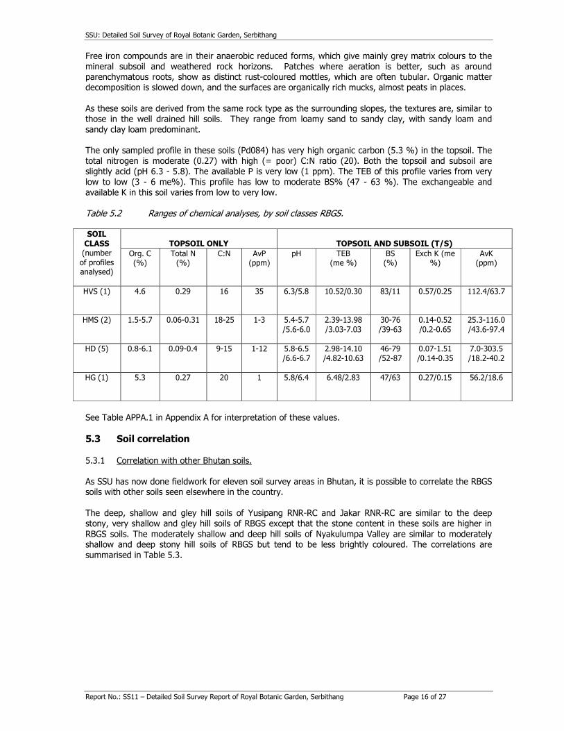
Table 5.2 Ranges of chemical analyses, by soil classes RBGS. SOIL
CLASS (number
of profiles analysed)
TOPSOIL ONLY
TOPSOIL AND SUBSOIL (T/S)
Org. C (%)
Total N (%)
C:N AvP (ppm)
pH TEB (me %)
BS (%)
Exch K (me %)
AvK (ppm)
HVS (1)
4.6 0.29 16 35 6.3/5.8 10.52/0.30 83/11 0.57/0.25 112.4/63.7
HMS (2)
1.5-5.7 0.06-0.31 18-25 1-3 5.4-5.7
/5.6-6.0
2.39-13.98
/3.03-7.03
30-76
/39-63
0.14-0.52
/0.2-0.65
25.3-116.0
/43.6-97.4
HD (5)
0.8-6.1 0.09-0.4 9-15 1-12 5.8-6.5
/6.6-6.7
2.98-14.10
/4.82-10.63
46-79
/52-87
0.07-1.51
/0.14-0.35
7.0-303.5
/18.2-40.2
HG (1)
5.3 0.27 20 1 5.8/6.4 6.48/2.83 47/63 0.27/0.15 56.2/18.6
See Table APPA.1 in Appendix A for interpretation of these values.
5.3 Soil correlation
5.3.1 Correlation with other Bhutan soils.
As SSU has now done fieldwork for eleven soil survey areas in Bhutan, it is possible to correlate the RBGS soils with other soils seen elsewhere in the country.
The deep, shallow and gley hill soils of Yusipang RNR-RC and Jakar RNR-RC are similar to the deep
stony, very shallow and gley hill soils of RBGS except that the stone content in these soils are higher in
RBGS soils. The moderately shallow and deep hill soils of Nyakulumpa Valley are similar to moderately shallow and deep stony hill soils of RBGS but tend to be less brightly coloured. The correlations are
summarised in Table 5.3.
SSU: Detailed Soil Survey of Royal Botanic Garden, Serbithang
Report No.: SS11 – Detailed Soil Survey Report of Royal Botanic Garden, Serbithang Page 17 of 27
Table 5.3 Correlations of RBGS soil classes with previous SSU soil surveys.
RBGS soil class Yusipang RNR-RC. [SSU Report 1a]
Bathpalathang , Jakar RNR-RC
[SSU Report 2a]
Nyakulumpa Valley [SSU Report 10a]
HVS
Hs Hs -
HMS
Hm - HM
HD
Hd Hd HD
HG
Hg Hg -
5.3.2 Correlation with international soil classifications
The local classification used in Table 5.1 and Section 5.2 aims to be simple and to clearly indicate the
main soil features to those specifically interested in soils in Royal Botanic Garden, Serbithang and Bhutan. The classes and their names are too generally defined to convey much to people outside Bhutan. To
facilitate international communication, the classes are correlated with the two main international system
of soil classification in Table 5.4. The correlations are discussed further in Appendix C. Table 5.4 International correlation of soil classes at RBG, Serbithang
Soil class Subunit in FAO world
Reference Base for Soil Resources. (FAO 1998)
Great group in USDA Soil
Taxonomy (Soil Survey Staff 1998) [Family in italics]
Code
Name
HVS Very shallow hill soil
Dystric Cambisol Dystric Haplustept. (mesic, loamy, mixed)
HMS
Moderately shallow hill soil
Dystric & Eutric Cambisol Dystric or typic Haplustept. (mesic, loamy, mixed)
HD Deep stony hill soil
Eutric Cambisol
Anthraquic or typic Haplustept. (mesic, loamy, mixed)
HG
Poorly drained hill side gley
Dystric & Eutric Gleysol Dystric & Typic Endoaquept & Epiaquept. (mesic, coarse loamy,
mixed)
5.3.3 Correlation with CIP geotechnical classification of soils. The stability of soil terraces and water conveyance systems are critical features of soils for agricultural
development in Bhutan. The Irrigation Section of REID of MOA has prepared a geotechnical classification
of soils specifically for canal and terrace stability in Bhutan conditions. RBGS is using some supplementary
irrigation in the establishment of some of its larger plantings. Although irrigation will not be a significant part of the long-term management of the Garden, the Irrigation Section geotechnical classification is
useful as a general indication of soil and slope stability. Table 5.5 correlates the soil classes of RBGS, Serbithang with the classification. The rock classifications have been omitted because all of the RBGS
soils parent materials quality for the same geotechnical lithological group, i.e. gneiss with quartzite. As is
generally found on the Thimphu Formation, the hill soils are relatively stable but can destabilised by
excessive loading when wet.

SSU: Detailed Soil Survey of Royal Botanic Garden, Serbithang
Report No.: SS11 – Detailed Soil Survey Report of Royal Botanic Garden, Serbithang Page 18 of 27
Table 5.5 Geotechnical correlation of soils of Royal Botanic Garden RBG soil class
REID Irrigation Section Geotechnical Soil Classification
Land unit Soil class
HVS
3A
SC- clay sand
CL- low plasticity sandy clay HMS
HD 3A/B
HG 3B
* Source for class criteria: CIP (1993)
SSU: Detailed Soil Survey of Royal Botanic Garden, Serbithang
Report No.: SS11 – Detailed Soil Survey Report of Royal Botanic Garden, Serbithang Page 19 of 27
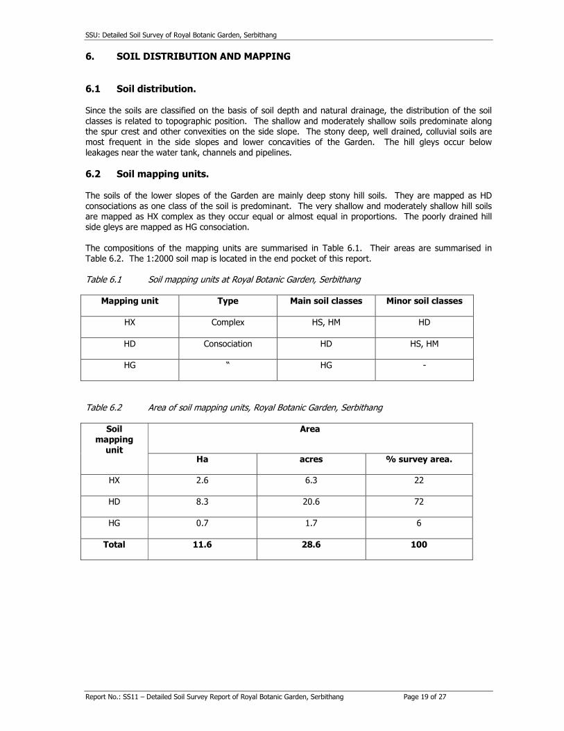
6. SOIL DISTRIBUTION AND MAPPING
6.1 Soil distribution. Since the soils are classified on the basis of soil depth and natural drainage, the distribution of the soil
classes is related to topographic position. The shallow and moderately shallow soils predominate along the spur crest and other convexities on the side slope. The stony deep, well drained, colluvial soils are
most frequent in the side slopes and lower concavities of the Garden. The hill gleys occur below
leakages near the water tank, channels and pipelines.
6.2 Soil mapping units. The soils of the lower slopes of the Garden are mainly deep stony hill soils. They are mapped as HD
consociations as one class of the soil is predominant. The very shallow and moderately shallow hill soils are mapped as HX complex as they occur equal or almost equal in proportions. The poorly drained hill
side gleys are mapped as HG consociation.
The compositions of the mapping units are summarised in Table 6.1. Their areas are summarised in
Table 6.2. The 1:2000 soil map is located in the end pocket of this report. Table 6.1 Soil mapping units at Royal Botanic Garden, Serbithang
Mapping unit
Type Main soil classes Minor soil classes
HX
Complex HS, HM HD
HD
Consociation HD HS, HM
HG
“ HG -
Table 6.2 Area of soil mapping units, Royal Botanic Garden, Serbithang
Soil mapping
unit
Area
Ha acres % survey area.
HX
2.6 6.3 22
HD
8.3 20.6 72
HG
0.7 1.7 6
Total
11.6 28.6 100
SSU: Detailed Soil Survey of Royal Botanic Garden, Serbithang
Report No.: SS11 – Detailed Soil Survey Report of Royal Botanic Garden, Serbithang Page 20 of 27
7. OVERVIEW AND IMPLICATIONS
7.1 Overview of soils. In general the soils of the Royal Botanic Garden at Serbithang contain a limited range of soils, on account
of its small area. The deep stony soils are the most extensive, and the gley soil, the least extensive. The shallow and moderately shallow hill soils on steep, runoff-shedding convex sites are liable to considerable
moisture stress during periods of dry weather.
The soils that have the best balance of good drainage and sufficient depth to give substantial water
holding capacity are the well-drained deep stony soils (mapping unit HD). However these soils are very stony and this reduces effective soil depth. At the other end of the range, the poorly drained side slope
soils have excessive soil water and poor aeration.
7.2 Implications of results In addition to supplying general information on an important element of the environment, the results of
the soil survey can be applied to specific aspects of RBGS.
In particular the results can contribute to the following:
• Are the soils of RBGS typical of the eco-climatic zone?
• Which type or species of plant will do well?
• Can be used for educational purposes, such as demonstrating the soils to students and other
visitors and correlating them with other soils in Bhutan. It should also increase awareness of the
importance of soils and their contribution to environmental systems.
The soils of RBGS are similar to those seen by SSU elsewhere in the 2000 m - 3000 m altitudinal zone on the Thimphu Formation. The Garden therefore appears suitable for the plantation and maintenance of a
wide of range of the plants typical of its zone. Local factors, which may constrain management, include
the shallowness and doughtiness of the ridge side and the poor drainage of the marshy patches. The moisture stress on the spur crest may be slightly alleviated by the northerly aspect of the Garden.
However the aspect will slightly exacerbate the poor drainage of the wet patches.
The RBGS will be a useful site for the National Soil Services Centre and Soil Survey to publicise soil features and their importance. SSU anticipates collaborating with the management of RBGS in some soils
outreach activities in the future.
SSU: Detailed Soil Survey of Royal Botanic Garden, Serbithang
Report No.: SS11 – Detailed Soil Survey Report of Royal Botanic Garden, Serbithang Page 21 of 27
REFERENCES
AHT (1995). Report on the interpretation of soil analytical results from the Soil and Plant Analytical Laboratory, Simtokha, and the formulation of a national soil classification system. Agrar- und Hydrotechnik GmbH, Essen for REID, MoA & EU.
SSU (1998). Technical report on the detailed soil survey of Yusipang RNR Rearch Centre. Report SS 1 (a). Bhutan Soil Survey Project, REID, MoA.
SSU (1998). Technical report on the detailed soil survey of Bathpalathang site, Jakar RNR Rearch Centre. Report SS 2 (a). Bhutan Soil Survey Project, REID, MoA.
SSU (1998). Technical report on the detailed soil survey of Nyakulumpa Valley. Report SS 10 (a). Bhutan Soil Survey Project, REID, MoA.
CIP (1993). Geotechnical manual. Community Irrigation Project, Irrigation Section, REID, MoA.
ESCAP (1991). Atlas of mineral resources of the ESCAP region. Economic and Social Commission for Asia and the Pacific, with Department of Geology and Mines, Thimphu.
FAO (1990). Guidelines for soil description. Food & Agriculture Organisation of United Nations, Rome.
FAO (1998). World Reference Base for Soil Resourses (ISRIC development of FAO system of soil
classification)
Gansser A (1983). Geology of the Bhutan Himalaya. Birkhauser Verlag, Basel.
Grierson AJC & Long DG (1983, 1984, 1987 &1991). Flora of Bhutan. Vol. 1, Part 1, 2 & 3 & Vol. 2 Part 1, RBG Edinburgh.
GSB (nd). Geology and mineral resources of Thimphu district. Geological Survey of Bhutan (with Geological Survey of India).
Jangpani BS (1968). Geology of parts of Thimphu District, Bhutan. GIS Bhutan Unit unpubl. LUPP (1995). Planning surveys of Gidakom Valley. Report on detailed surveys in the pilot study area. Vol. II. The soils annex . Soil profile descriptions and analysis results. Vol. IV, Land Use Planning Project, Planning and Policy Division, MoA.
Noltie HJ (1994). Flora of Bhutan. Vol. 3, Part 1. 456 pp RBG Edinburgh.
Polunin O. & Stainton A (1984). Flowers of the Himalayas. OUP , Delhi.
Soil Survey Staff (1975). Soil Taxonomy. US Department of Agriculture, Washington, DC.
Soil Survey Staff (1998). Keys to Soil Taxonomy: Eighth edition. US Department of Agriculture,
Washington, DC.
SPAL (1993). Soil analysis. Soil and Plant Analytical Laboratory, REID, MoA.

SSU: Detailed Soil Survey of Royal Botanic Garden, Serbithang
Report No.: SS11 – Detailed Soil Survey Report of Royal Botanic Garden, Serbithang Page 22 of 27
APPENDIX A: SUMMARY OF METHODS OF SOIL ANALYSIS
The full details of the methods used at SPAL are given in ‘Soil Analysis’ (SPAL 1993).
The SPAL methods vary slightly according to soil pH. The methods summarized below are those for soils of pH (water) both > 7 and < 7, as samples of both types were collected during this survey. There are
few samples of pH (water) < 5.5, so extractable Al and H were not determined. No particle size compositions were determined.
Sample preparation
Samples are air - dried, aggregates are hand crushed, and the soil is sieved to 2 mm.
pH
Soil pH is measured in suspensions of the soil in distilled water and 1 M KCL (both 1:2.5) using a PHM 83
automatic pH meter.
Soil extracts
The fine earth fraction is subject to a number of extraction procedures:
Total N is extracted and converted into ammonium form by micro-Kjeldahl digestion with H2SO4 and a Se-
based catalyst.
Ammonium – N and nitrate – N are extracted by shaking with 0.01 M CaCl2 for two hours.
For soils with pH (water) < 7, available P is extracted by shaking 5 g of fine earth with 35 ml of the Bray
and Kurtz extractant of 0.5 M HCl and 1 M NH4F for 1 minute. For soils with pH > 7, available P is extracted by shaking 5 g of fine earth with 35 ml of the Olsen extractant of 0.5 M Na HCO3 and 1 M
NaOH for 1 minute.
Available K is extracted by shaking 5 g of fine earth with 50 ml of 0.01 M CaCl2 for 2 hours.
Exchangeable Ca, Mg, K and Na are extracted by leaching 5 g of fine earth with 100 ml of 1 M
ammonium acetate (NH4OAc).
For the soils with pH (water) < 7.5, the ammonium is extracted by leaching the soil with excess 1 M KCl,
and measured to give the Cation Exchange Capacity. For the soil with pH (water) > 7.5, the ammonium
is extracted by leaching with excess 1 M sodium acetate.
Assays of extracts
The NH4 in the extracts from the Total N digestion, the KCl leaching for CEC determination, and from NH4
– N; NO3 – N; available P; available K; and exchangeable K and Na in the different extracts are measured
with the Skalar Segmented Flow Analyser system, which includes colorimeters for NH4, NO3 and P, and a flame spectrophotometer for K and Na.
Exchangeable Ca and Mg in the NH4OAc leachate are measured with a Unicam Atomic Adsorption
Spectrophotometer.
For acid soils, extractable acidity (Al + H) in the KCl leachate are measured by titration with 0.05 M
NaOH, and extractable Al alone is measured by a second titration with 0.05 M HCl, after the addition of NaF.
Organic carbon
OC is measured by the Walkley – Black method of low temperature oxidation with acidified K2Cr2O7 and titration of the excess dichromate.

SSU: Detailed Soil Survey of Royal Botanic Garden, Serbithang
Report No.: SS11 – Detailed Soil Survey Report of Royal Botanic Garden, Serbithang Page 23 of 27
TEB, ECEC, BS and C:N
Total exchangeable bases, effective cation exchange capacity, base saturation, and C:N ratios are derived
by computation, i.e.;
TEB = Exchangeable Ca + Mg + K + Na.
ECEC = TEB + Extractable Al.
BS (NH4OAc) = TEB / CEC (NH4OAc).
EBS = TEB / ECEC.
C:N = Organic C / Total N.
The analytical results from SPAL are interpreted according to the criteria summarised in Table A.1.
Table A.1 Summary of 1995 recommendations for interpretation of SPAL soil analyses
V. High High Moderate Low V. Low
pH > 7.6 * (alkaline)
6.6 - 7.5 (neutral)
5.6 - 6.5 (s. acid)
4.6 - 5.5 (v. acid)
< 4.5 (ext. acid)
EC mS/cm > 2.00 0.8 - 1.99 0.4 - 0.79 0.15 - 0.39 < 0.15
CEC (NH4OAC) me% > 40 25 - 39.9 15 - 24.9 5 - 14.9 < 5
XCa me%
> 20 10 - 19.9 5 - 9.9 2 - 4.9 < 2
XMg
me%
> 8 3 - 7.9 1.5 - 2.9 0.5 - 1.4 < 0.5
XK me%
> 1.2 0.6 - 1.19 0.3 - 0.59 0.1 - 0.29 < 0.1
XNa me%
> 2 0.7 - 1.99 0.3 - 0.69 0.1 - 0.29 < 0.1
TEB
me%
> 30 15 - 29.9 7.5 - 14.9 3 - 7.4 < 3
XAl me%
> 10 5 - 9.9 2 - 4.9 0.5 - 1.9 < 0.5
ECEC me%
> 30 20 - 29.9 12 - 19.9 4 - 11.9 < 4
BS % (NH4OAc)
> 80 65 - 79 50 - 64 35 - 49 < 35
EBS % > 80 50 - 79 35 - 49 20 - 34 < 20
Ca:Mg > 20 13 - 19.9 7 - 12.9 3 - 6.9 < 3
AvK
ppm
> 300 200 - 299 100 - 199 40 - 99 < 40
AvP ppm
> 30 15 - 29 5 - 14 < 5
Org. C %
> 5 3.1 - 4.9 1.2 - 3 0.6 - 1.1 < 0.6
Total N % > 1 0.5 - 0.99 0.2 - 0.49 0.1 - 0.19 < 0.1
C:N > 50 (v. poor)
20 - 49 (poor)
15 - 19 (moderate)
10 - 14 (good)
< 10 (v. good)
Source: AHT 1995.
SSU: Detailed Soil Survey of Royal Botanic Garden, Serbithang
Report No.: SS11 – Detailed Soil Survey Report of Royal Botanic Garden, Serbithang Page 24 of 27
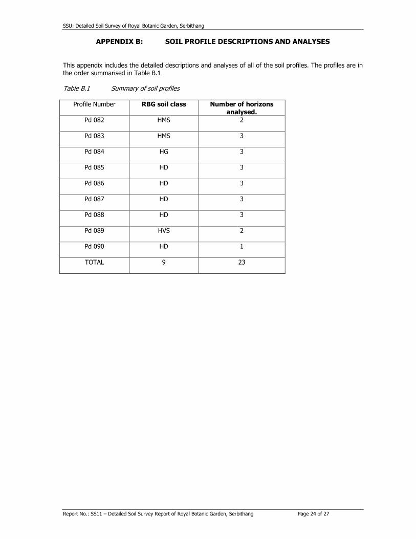
APPENDIX B: SOIL PROFILE DESCRIPTIONS AND ANALYSES
This appendix includes the detailed descriptions and analyses of all of the soil profiles. The profiles are in
the order summarised in Table B.1
Table B.1 Summary of soil profiles
Profile Number RBG soil class Number of horizons
analysed.
Pd 082
HMS 2
Pd 083
HMS 3
Pd 084
HG 3
Pd 085
HD 3
Pd 086
HD 3
Pd 087
HD 3
Pd 088
HD 3
Pd 089
HVS 2
Pd 090
HD 1
TOTAL
9 23


SSU: Detailed Soil Survey of Royal Botanic Garden, Serbithang
Report No.: SS11 – Detailed Soil Survey Report of Royal Botanic Garden, Serbithang Page 25 of 27
APPENDIX C: CORRELATION OF RBGS SOILS
C.I Soil classification and correlation in Bhutan
Table 5.3 in the main report summarises the correlation of the RBGS soil classes with the international soil classifications. This appendix discusses the reasoning behind the correlations assigned.
The USDA Soil Taxonomy (USDA 1998) was originally developed to meet the needs of soil survey in the
continental United States. It has been extended since then, but it is still stronger on temperate than on
tropical soils. It is detailed and comprehensive. The FAO system (FAO 1998) is more globally oriented, and is less detailed but quite comprehensive. It has the advantage that it uses more traditional and
comprehensible soil names.
Pedologists working in Nepal have mostly used the Soil Taxonomy but previous consultants in Bhutan
have preferred the FAO system. At this stage it is not necessary for Bhutan to choose between the two systems. It is intended that, at present, SSU will use local soil classes and names within Bhutan, and will
correlate them against both of the international systems (AHT 1995).
C.2 General criteria
Before considering individual soils, there are some environmental characteristics of the area as a whole
that need to be determined before the application of Soil Taxonomy.
C.2.1 Soil moisture regime
This is necessary for the assignment suborders or great groups in Soil Taxonomy. In the absence of soil
moisture data, soil moisture regimes are nomally approximated from rainfall totals and distribution. RBGS probably has an ustic atmospheric climate, which is defined as having more 90 consecutive dry days per
year and having a summer rainfall distribution. All of the soils at RBGS are assumed to have ustic soil moisture regimes except for the poorly drained soils. These have an aquic moisture regime, which refers
to soils that are permanently wet due to their topographic position or the continuous inflow of water.
C.2.2 Soil temperature regime
This is a criterion for classification at family level in Soil Taxonomy. In the absence of soil temperature
data, atmospheric temperatures are used. RBGS has a mesic atmospheric temperature regime, with an
annual mean between 80 C and 150 C and a summer – winter difference greater than 50 C. All of the soils at RBGS are assumed to have mesic soil temperature regimes.
C.2.3 Mineralogy class
This is another family criterion in Soil Taxonomy. Although muscovite is a highly visible component in
many soils at RBGS, mica contents are less than 40 % of the sand and gravel fractions, so that the soils
do not qualify for the micaceous class, and have to be classified in the mixed mineralogy class.
C.2.4 Particle size class.
This varies with stone content and fine earth texture, and therefore varies for the different soil classes at
RBGS, although most are fine loamy or loamy – skeletal.
C.3 Correlation of RBGS soils
C.3.1 Very shallow hill soil
Most of these soils appear to be sedentary and the gneiss and schist components of the parent material
are quite deeply weathered. These soils fit well into the Inceptisols of Soil Taxonomy or the Cambisols of WRB. Because of the low base saturations in the single analysed profile, they are sub - classified as
Dystric.

SSU: Detailed Soil Survey of Royal Botanic Garden, Serbithang
Report No.: SS11 – Detailed Soil Survey Report of Royal Botanic Garden, Serbithang Page 26 of 27
C.3.2 Moderately shallow hill soil
Most of these soils appear to be sedentary and quite deeply weathered. Their subsoils have slightly
higher clay contents than the topsoil but clayskins are not common. These soil fit well into the Inceptisols
of Soil Taxonomy or the Cambisols of WRB. The soil moisture regime puts them into the Ustept suborder.
Because they have variable base saturations, they qualify for both Dystric and Eutric groups. In WRB,
similar criteria apply, and these soils mostly qualify as Dystric and Eutric Cambisols. A few may qualify as Humic Cambisols.
C.3.3 Deep stony hill soils
These soils consist of recent, colluvial deposits of fairly intensively weathered material. In Soil Taxonomy,
the degree of weathering has priority over the layering in keying out, so that most of these soils qualify
as Typic Haplustept. In WRB, these soils qualify as Eutric Cambisols. C.3.4 Poorly drained hill side gley soil
The impeded drainage is the main classification criterion in these soils. In Soil Taxonomy, most of them
are considered to be Aquepts. Many of these soils are kept wet for long periods by shallow subsurface throughflow. This makes the drainage of their upper layers worse than in the lower subsoils, and the soils
therefore qualify as Epiaquepts rather than groundwater - fed Endoaquepts. This distinction is not made
in WRB, and these soils qualify as Dystric and Typic Gleysols.

SSU: Detailed Soil Survey of Royal Botanic Garden, Serbithang
Report No.: SS11 – Detailed Soil Survey Report of Royal Botanic Garden, Serbithang Page 27 of 27
APPENDIX D: Soil Survey Unit
D.1 SSU
The Bhutan Soil Survey Project (SSU) was set up by an Agreement signed in September 1996 by the Royal Government of Bhutan (RGOB) and Danish International Development Assistance (Danida). It was
initiated because of a perceived need for systematic information about the nature and distribution of the soils of Bhutan. The Project is part of the National Soils Services Centre of the Research, Extension and
Irrigation Division in the Ministry of Agriculture. Table D.1 lists the main soil survey reports issued so far.
Table D.1 SSU main surveys and reports
SSU No. Title Status February, 2000
1 & 1(a) General & Technical reports of detailed soil survey of Yusipang RNR-RC
Final, distributed 7/98
2 & 2(a) General & Technical reports of detailed soil survey of Bathpalathang site, Jakar RNR-RC
Final, distributed, 9/98
SS 3 & SS
3(a)
General & Technical reports of detailed soil survey
of Bajo RNR-RC
Final, distributed,
12/98
SS 4 & SS4(a)
General & Technical reports of detailed soil survey of Khangma RNR-RC
Final, distributed, 3/99
SS 5 & SS 5(a)
General & Technical reports of semi-detailed soil survey of Lingmutey Chhu watershed
Final, distributed, 5/99 & 10/99
SS 6 & SS
6(a)
General & Technical reports of semi-detailed soil
survey of Radhi geog
Final, distributed,
12/99.
SS 7 & SS
7(a)
General & Technical reports of semi-detailed soil
survey of Lame Gompa Research Forest
Final, distributed,
1/2000
SS 8
Report of reconnaissance survey of soils of Merak
and Sakten
Final, distributed,
11/99.
SS 9 & SS
9(a)
General & Technical reports of semi-detailed soil
survey of arable lands of middle Tsang Chhu valley
Fieldwork in progress
SS 10 & 10
(a)
General and Technical reports of semi-detailed soil
survey of arable lands of Nyakulumpa valley, Punakha
Final, distributed,
10/99
SS 11(a) Technical report of detailed soil survey of Royal Botanic Garden, Serbithang
Final, distributed, 3/2000