Embed Size (px)
Citation preview
Royal Government of BhutanSoil Survey Unit (SSU)
National Soil Services Centre (NSSC)Department of Agriculture (DoA)
Ministry of Agriculture & Forests (MoAF)
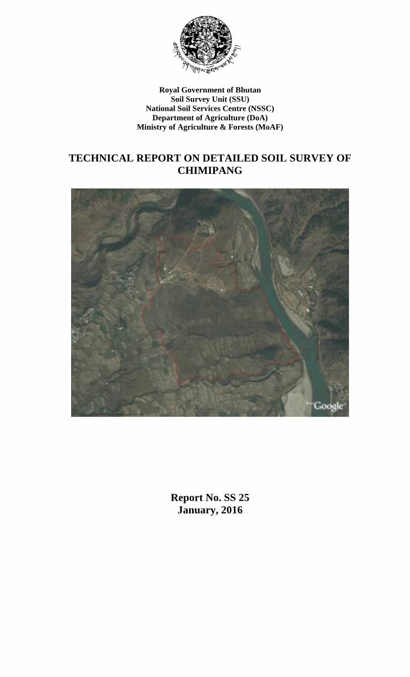
TECHNICAL REPORT ON DETAILED SOIL SURVEY OFCHIMIPANG
Report No. SS 25January, 2016
Detailed soil survey report of Chimipang Soil Survey Unit, NSSC
Report No: SS 25 Page 2 of 42
CONTENTS
SUMMARY 4
S.1 Background 4
S.2 Location and Environment 4
S.3 Soils 5Figure 1 Soil Map 5Table 1 Description for Soil Map 6
S.4 Recommendations 7
ACKNOWLEDGEMENT 8
ABBREVIATIONS & GLOSSARY 9
1. INTRODUCTION 10
1.1 Background 10
1.2 Aims of the Survey 10
2. THE SURVEY AREA 11
2.1 Location and Extent 11
2.2 Climate 11Figure 2 Location of the survey site 12Table 2 Climatic Summary from RNRDC, Bajo, Wangduephodrang (2003 – 2012) 13
2.3 Geology and Soil Parent Materials (SPM) 14
2.4 Topography and Drainage 14
2.5 Land Use and Vegetation 15
3. METHODS 16
3.1 Pre-field Work 16
3.2 Field 163.2.1 General 16
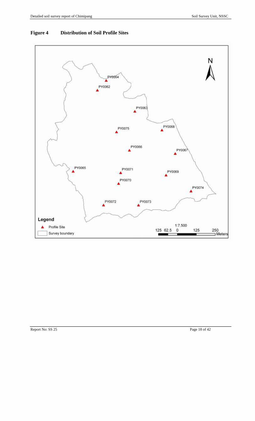
Figure 3 Distribution of Soil Auger Sites 17Figure 4 Distribution of Soil Profile Sites 18
3.2.2 Site Data 193.2.3 Soil Data 19
(a) Auger Sites 19(b) Profile Pit Sites 20
3.3 Mapping 203.3.1 Maps produced and used during the survey 20
Table 3 Maps Compiled and Used during the Survey 21
Detailed soil survey report of Chimipang Soil Survey Unit, NSSC
Report No: SS 25 Page 3 of 42
3.3.2 Final Map Presentation 21
3.4 Laboratory 21
3.5 Data Storage 21
4. SOIL CLASSIFICATION, CHARACTERISTICS & CORRELATION 22
4.1 Soil Classification 22Table 4 Summary of the Soil Series 22Figure 5 Distribution of Soil Series 23Table 5 General Characteristics of Soil Series 24Table 6 Description of Soil Series 24Table 7 Description of Soil Chemistry / Fertility 25
4.2 Soil Fertility Status 264.2.1 Soil Reaction 264.2.2 Inherent Fertility 264.2.3 Fertility Potential 26
4.3 Soil Correlation 264.3.1 Previous Survey 26
Table 8 Correlation with Soils Classes of Lingmutey Chhu Watershed and Nyakalumpa 27Table 9 Soils of Lingmutey Chhu Watershed 27Table 10 Soils of Nyakalumpa valley 27
4.3.2 International Correlations 28Table 11 Correlation with International Systems of Soil Classification 29
5. SOIL DISTRIBUTION AND MAPPING 30
5.1 Soil Distribution 30
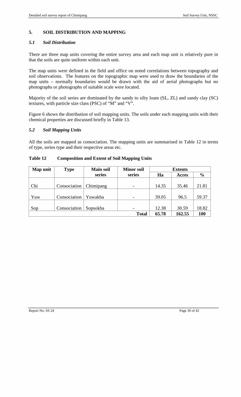
5.2 Soil Mapping Units 30Table 12 Composition and Extent of Soil Mapping Units 30Figure 6 Distribution of Soil Mapping Units 31Table 13 Brief Description of Soil Mapping Units 32
5.2.1 “Chi” map unit 325.2.2 “Yuw” map unit 325.2.3 “Sop” map unit 32
6. OVERVIEW AND IMPLICATIONS 33
6.1 Overview of the Soils 33
7. RECOMMENDATIONS 34
APPENDIX A CHEMICAL CHARATERISTICS 35
APPENDIX B TYPICAL SOIL PROFILE DESCRIPTIONS 37
Detailed soil survey report of Chimipang Soil Survey Unit, NSSC
Report No: SS 25 Page 4 of 42
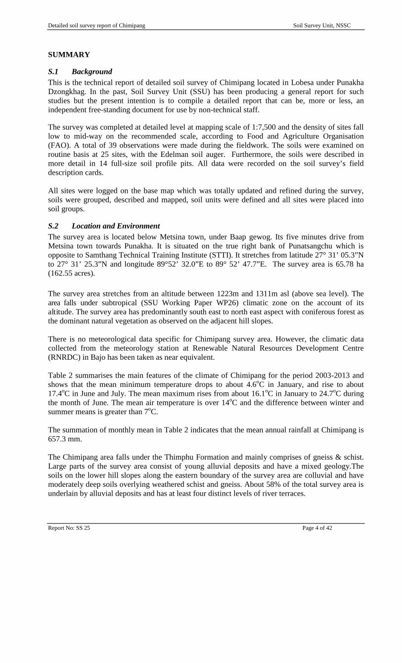
SUMMARY
S.1 BackgroundThis is the technical report of detailed soil survey of Chimipang located in Lobesa under PunakhaDzongkhag. In the past, Soil Survey Unit (SSU) has been producing a general report for suchstudies but the present intention is to compile a detailed report that can be, more or less, anindependent free-standing document for use by non-technical staff.
The survey was completed at detailed level at mapping scale of 1:7,500 and the density of sites falllow to mid-way on the recommended scale, according to Food and Agriculture Organisation(FAO). A total of 39 observations were made during the fieldwork. The soils were examined onroutine basis at 25 sites, with the Edelman soil auger. Furthermore, the soils were described inmore detail in 14 full-size soil profile pits. All data were recorded on the soil survey’s fielddescription cards.
All sites were logged on the base map which was totally updated and refined during the survey,soils were grouped, described and mapped, soil units were defined and all sites were placed intosoil groups.
S.2 Location and EnvironmentThe survey area is located below Metsina town, under Baap gewog. Its five minutes drive fromMetsina town towards Punakha. It is situated on the true right bank of Punatsangchu which isopposite to Samthang Technical Training Institute (STTI). It stretches from latitude 27° 31’ 05.3”Nto 27° 31’ 25.3”N and longitude 89°52’ 32.0”E to 89° 52’ 47.7”E. The survey area is 65.78 ha(162.55 acres).
The survey area stretches from an altitude between 1223m and 1311m asl (above sea level). Thearea falls under subtropical (SSU Working Paper WP26) climatic zone on the account of itsaltitude. The survey area has predominantly south east to north east aspect with coniferous forest asthe dominant natural vegetation as observed on the adjacent hill slopes.
There is no meteorological data specific for Chimipang survey area. However, the climatic datacollected from the meteorology station at Renewable Natural Resources Development Centre(RNRDC) in Bajo has been taken as near equivalent.
Table 2 summarises the main features of the climate of Chimipang for the period 2003-2013 andshows that the mean minimum temperature drops to about 4.6oC in January, and rise to about17.4oC in June and July. The mean maximum rises from about 16.1oC in January to 24.7oC duringthe month of June. The mean air temperature is over 14oC and the difference between winter andsummer means is greater than 7oC.
The summation of monthly mean in Table 2 indicates that the mean annual rainfall at Chimipang is657.3 mm.
The Chimipang area falls under the Thimphu Formation and mainly comprises of gneiss & schist.Large parts of the survey area consist of young alluvial deposits and have a mixed geology.Thesoils on the lower hill slopes along the eastern boundary of the survey area are colluvial and havemoderately deep soils overlying weathered schist and gneiss. About 58% of the total survey area isunderlain by alluvial deposits and has at least four distinct levels of river terraces.
Detailed soil survey report of Chimipang Soil Survey Unit, NSSC
Report No: SS 25 Page 5 of 42
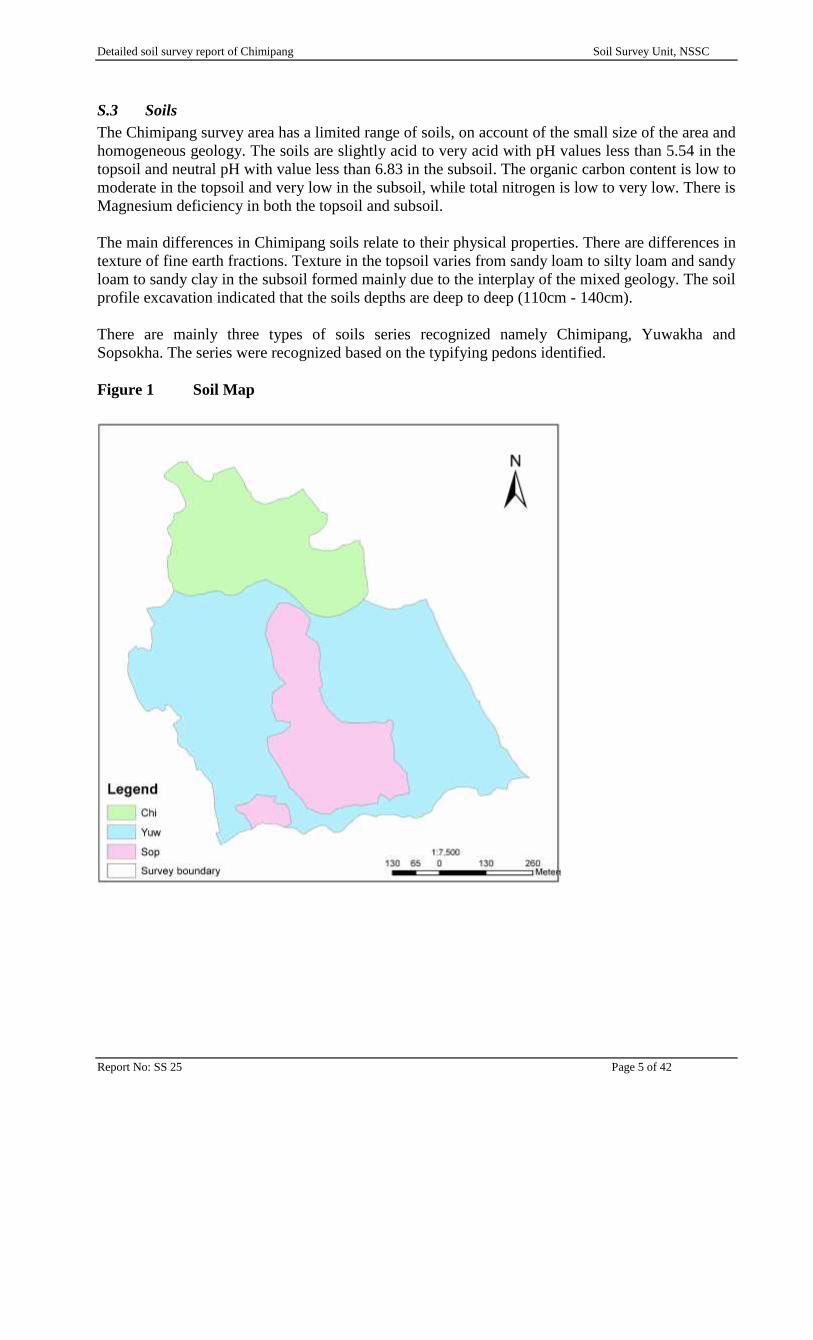
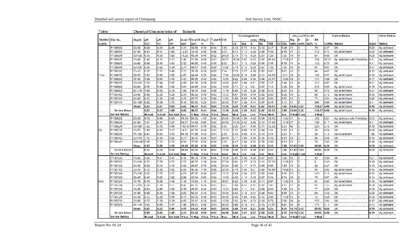
S.3 SoilsThe Chimipang survey area has a limited range of soils, on account of the small size of the area andhomogeneous geology. The soils are slightly acid to very acid with pH values less than 5.54 in thetopsoil and neutral pH with value less than 6.83 in the subsoil. The organic carbon content is low tomoderate in the topsoil and very low in the subsoil, while total nitrogen is low to very low. There isMagnesium deficiency in both the topsoil and subsoil.
The main differences in Chimipang soils relate to their physical properties. There are differences intexture of fine earth fractions. Texture in the topsoil varies from sandy loam to silty loam and sandyloam to sandy clay in the subsoil formed mainly due to the interplay of the mixed geology. The soilprofile excavation indicated that the soils depths are deep to deep (110cm - 140cm).
There are mainly three types of soils series recognized namely Chimipang, Yuwakha andSopsokha. The series were recognized based on the typifying pedons identified.
Figure 1 Soil Map
Detailed soil survey report of Chimipang Soil Survey Unit, NSSC
Report No: SS 25 Page 6 of 42
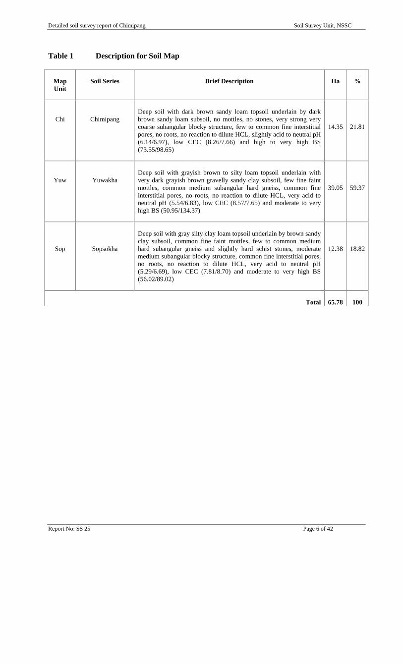
Table 1 Description for Soil Map
MapUnit
Soil Series Brief Description Ha %
Chi ChimipangDeep soil with dark brown sandy loam topsoil underlain by darkbrown sandy loam subsoil, no mottles, no stones, very strong verycoarse subangular blocky structure, few to common fine interstitialpores, no roots, no reaction to dilute HCL, slightly acid to neutral pH(6.14/6.97), low CEC (8.26/7.66) and high to very high BS(73.55/98.65)
14.35 21.81
Yuw YuwakhaDeep soil with grayish brown to silty loam topsoil underlain withvery dark grayish brown gravelly sandy clay subsoil, few fine faintmottles, common medium subangular hard gneiss, common fineinterstitial pores, no roots, no reaction to dilute HCL, very acid toneutral pH (5.54/6.83), low CEC (8.57/7.65) and moderate to veryhigh BS (50.95/134.37)
39.05 59.37
Sop Sopsokha
Deep soil with gray silty clay loam topsoil underlain by brown sandyclay subsoil, common fine faint mottles, few to common mediumhard subangular gneiss and slightly hard schist stones, moderatemedium subangular blocky structure, common fine interstitial pores,no roots, no reaction to dilute HCL, very acid to neutral pH(5.29/6.69), low CEC (7.81/8.70) and moderate to very high BS(56.02/89.02)
12.38 18.82
Total 65.78 100
Detailed soil survey report of Chimipang Soil Survey Unit, NSSC
Report No: SS 25 Page 7 of 42
S.4 RecommendationsBased on the physical and chemical characteristics of the soils, following recommendations aresuggested to improve the soil nutrient status of the site.
The soil pH is slightly acid to very acid in the topsoil. Based on the soil pH requirement bydifferent plants, the soil needs to be ameliorated, either by raising the pH through incorporationof lime or reducing the pH by adding sphagnum peat, acidifying fertilizers1 and organicmulches. This is to bring soil pH to a desirable range, where nutrients are easily available foruptake by the plants. Most agronomic crops grow well within moderate pH range and flowers inslightly acid to acid soils.
Nitrogen is the other primary nutrient needed by plants in larger quantities. The N content iswithin low to very low range, demanding addition of urea or ammonium nitrate fertilizer.
The CEC of the soil samples is low in range and this could be improved by incorporating welldecomposed FYM and other organic materials.
There is Mg deficiency and this could be improved by applying dolomite, which is a goodsource of calcium (Ca) and magnesium (Mg).
1 Acidifying fertilizers such as ammonium sulfate, urea, and ammonium nitrate
Detailed soil survey report of Chimipang Soil Survey Unit, NSSC
Report No: SS 25 Page 8 of 42
ACKNOWLEDGEMENT
The fieldwork for the survey was done in the month of March 2013 by Mr. Yeshey Chedup (SoilSurveyor).
The location, base and provisional soil maps were all drafted and digitized by Mrs. SangitaPradhan.
Other logistics such as labourers during the entire fieldwork was arranged by RNDDC, Bajo.
Soil analyses were done by the staff at Soil and Plant Analytical Laboratory (SPAL), National SoilServices Centre (NSSC).
The final report is compiled by Mr. Yeshey Chedup and Mr. Kinley Penjor
Detailed soil survey report of Chimipang Soil Survey Unit, NSSC
Report No: SS 25 Page 9 of 42
ABBREVIATIONS & GLOSSARY
(Simple metric units and chemical element symbols not included)
Acre Area of measurement, = 0.405 haasl Above sea levelAvP, AP Available PhosphateBHUSOD Bhutan Soil DatabankSSU Soil Survey UnitBS% Base saturation percentageca ApproximatelyCEC Cation exchange capacityChhu Term used for river or streamcm CentimetreC: N Carbon to Nitrogen RatioConsociation Soil mapping unit with one soil class dominant but others as minor
constituentsDoA Department of Agriculture.DoHS Department of Hydro-Met ServicesDSLR Department of Survey and Land RecordsExch Exchangeable (for cations)EWD Extremely well drained (soil)FAO Food and Agricultural Organisation of the United NationsFine earth Soil particle size < 2mmGIS Geographical information systemGPS Global positioning systemha HectareHCl Hydrochloric acidHorizon Soil layerKamzhing Rainfed agricultureMoAF Ministry of Agriculture and ForestsMoEA Ministry of Economic AffairsNSSC National Soil Services Centre, DoA, SemtokhaOC% Percentage of Organic Carbon ContentPM (Soil) Parent Materialppm Part per millionpH Measure of acidity - alkalinityProfile Sequence of horizons from surface down to unaltered parent materialSeries Main group of soil classes in Bhutan. Also sixth highest level of subdivision
in USDA Soil TaxonomySMR Soil Moisture Regime, defined in Soil TaxonomySMU Soil mapping unitSOM Soil Organic Mattersp, spp Species (singular & plural)SPAL Soils and Plant Analysis Laboratory, NSSC, DoA, Semtokha.STR Soil temperature regime, defined in Soil TaxonomyTN Total nitrogenUSDA United States Department of AgricultureWD Well drained (soil)WRB World Reference Base
Detailed soil survey report of Chimipang Soil Survey Unit, NSSC
Report No: SS 25 Page 10 of 42
1. INTRODUCTION
This technical report on soils of Chimipang under Punakha was produced at the scale of 1:7500 ondetailed survey level. It provides sufficient information on the characteristics and geographicdistribution of the soils for broad scale development planning and execution based on the detailedsoil profile descriptions and soil chemistry (fertility).
1.1 Background
As per the directive from Ministry of Agriculture and Forests, the National Soil Services Centre(NSSC) was called upon to conduct a detail soil survey of the site at Chimipang for the purpose ofdeveloping into an exemplary agricultural demonstration site.
1.2 Aims of the SurveyThe survey was undertaken with following objectives:
Provide sufficient detailed information on nature and spatial distribution of the soils Provide soil map at a suitable scale for better utilization and management Provide information on soil chemistry (fertility) Provide SSU with data for the further development of the national soil classification system
and to build up the database of national and regional soil maps Add soil information to the existing soil database (BHUSOD)
Detailed soil survey report of Chimipang Soil Survey Unit, NSSC
Report No: SS 25 Page 11 of 42
2. THE SURVEY AREA
2.1 Location and Extent
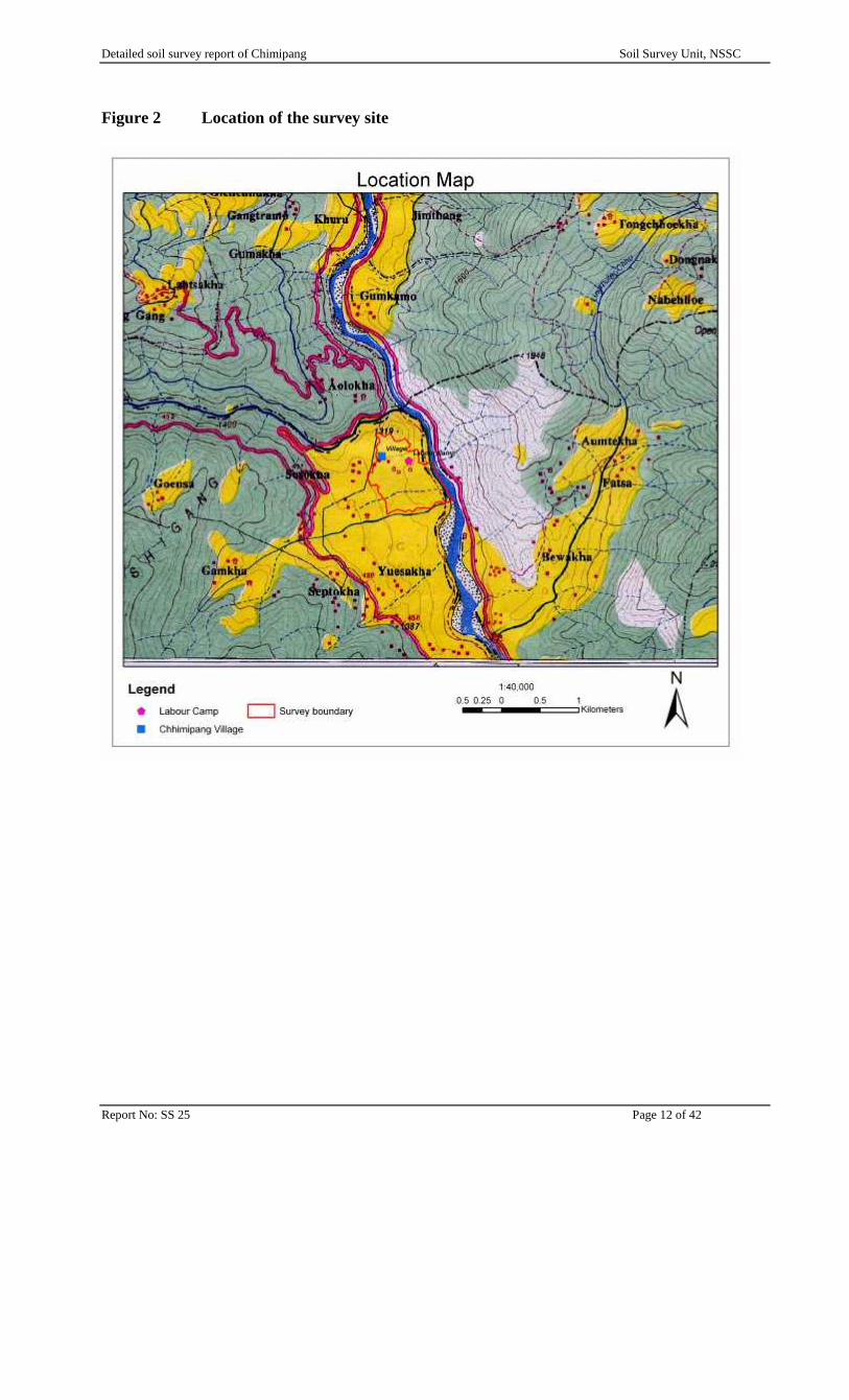
The proposed area is located below Metsina town, under Baap gewog. Its only five minutes drivefrom Metsina town towards Punakha. It is situated on the true right bank of Punatsangchu which isopposite to Samthang Technical Training Institute (STTI). It stretches from latitude 27° 31’ 05.3”Nto 27° 31’ 25.3”N and longitude 89°52’ 32.0”E to 89° 52’ 47.7”E. The site has a maximum North-East length of about 500m and a maximum East-West width of about 250m. It covers about 65.78ha (162.55 acres).
2.2 Climate
The survey area stretches from an altitude between 2386m and 2453m asl (above sea level). Thesite falls in the Sub-tropical (SSU Working Paper WP26) climatic zone on the account of itsaltitude. The site has predominantly easterly to east south east aspect with coniferous forest as thedominant natural vegetation as observed on the adjacent sites.
There is no meteorological data for the survey area. However, the climatic data from meteorologystation in RNRDC, Bajo under the Ministry of Agriculture and Forests has been taken as nearequivalent as it lies in the same altitude zone.
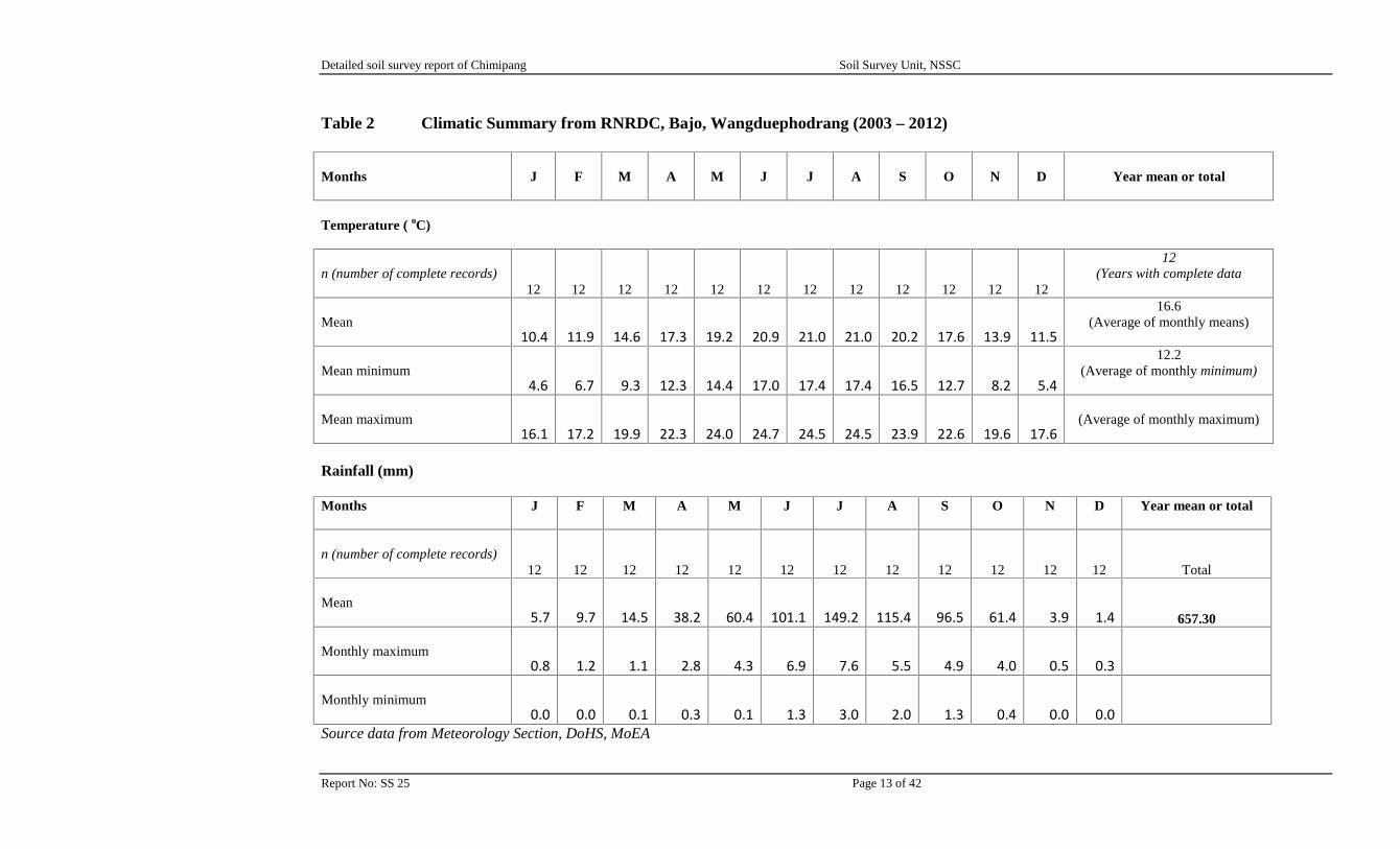
Table 2 summarises the main features of the climate of Chimipang for the period 2003-2013 andshows that the mean minimum temperature drops to about 4.6oC in January, and rise to about17.4oC in June and July. The mean maximum rises from about 16.1oC in January to 24.7oC duringthe month of June. The mean air temperature is over 14oC and the difference between winter andsummer means is greater than 7oC.
The summation of monthly mean in Table 2 indicates that the mean annual rainfall at thetechnology park is about 657.3 mm.
Detailed soil survey report of Chimipang Soil Survey Unit, NSSC
Report No: SS 25 Page 12 of 42
Figure 2 Location of the survey site
Detailed soil survey report of Chimipang Soil Survey Unit, NSSC
Report No: SS 25 Page 13 of 42
Table 2 Climatic Summary from RNRDC, Bajo, Wangduephodrang (2003 – 2012)
Months J F M A M J J A S O N D Year mean or total
Temperature ( oC)
n (number of complete records)12 12 12 12 12 12 12 12 12 12 12 12
12(Years with complete data
Mean10.4 11.9 14.6 17.3 19.2 20.9 21.0 21.0 20.2 17.6 13.9 11.5
16.6(Average of monthly means)
Mean minimum4.6 6.7 9.3 12.3 14.4 17.0 17.4 17.4 16.5 12.7 8.2 5.4
12.2(Average of monthly minimum)
Mean maximum16.1 17.2 19.9 22.3 24.0 24.7 24.5 24.5 23.9 22.6 19.6 17.6
(Average of monthly maximum)
Rainfall (mm)
Months J F M A M J J A S O N D Year mean or total
n (number of complete records)12 12 12 12 12 12 12 12 12 12 12 12 Total
Mean5.7 9.7 14.5 38.2 60.4 101.1 149.2 115.4 96.5 61.4 3.9 1.4 657.30
Monthly maximum0.8 1.2 1.1 2.8 4.3 6.9 7.6 5.5 4.9 4.0 0.5 0.3
Monthly minimum0.0 0.0 0.1 0.3 0.1 1.3 3.0 2.0 1.3 0.4 0.0 0.0
Source data from Meteorology Section, DoHS, MoEA
Detailed soil survey report of Chimipang Soil Survey Unit, NSSC
Report No: SS 25 Page 14 of 42
2.3 Geology and Soil Parent Materials (SPM)
The Chimipang area falls under the Thimphu Formation and mainly comprises of gneiss & schist.Large parts of the survey area consist of young alluvial deposits and have a mixed geology.
The soils on the lower hill slopes along the eastern boundary of the survey area are colluvial andhave moderately deep soils overlying weathered schist and gneiss. About 58% of the total surveyarea is underlain by alluvial deposits and has at least four distinct levels of river terraces.
The Centre is located almost entirely on the alluvial deposits of the Tsang Chhu and there are nooutcrops of bedrock. The alluvium is derived from the rocks of the upstream catchment.
The alluvial history of the section of the Tsang Chhu valley is complex. The rapid but irregularmovement downwards of the erosional base level has resulted in the deposition and subsequentdissection of successive levels of alluvium. The terraces of the highest and oldest group in thevicinity of the survey area are at about 100-130 m above the current river level. The full depth ofthese deposits is exposed in the road cuttings along the Khuru -Wangdi Highway down fromSamthang Technical Training Institute. This section shows that this alluvium is very heterogeneous,with beds of rounded boulders, inter-layered with beds of sand and pebbles. There are also massiveboulders (of up to 100 m3) which have been hardly rounded. These may be colluviums fragmentsthat have rolled down local slopes and been incorporated into the more traveled alluvium.
The middle group of terraces in the survey area is at about 25–40 m above the current river. Theupper part of the survey area (dry land) is located on these deposits. The steep slope at their loweredge reveals rounded boulders at depths of 2-3 m. From the Auger/profile boreholes on this terrace,the fragment of free alluvium is much deeper. The drilling data indicated that up to 40 m of sand,silt and clay alluvium overlies a dense bed of rounded boulders.
2.4 Topography and Drainage
The proposed site is located at the true right hand side of Punatsang Chhu. This section of thevalley is very wide as it is downstream, but it still forms a relatively wide basin of moderatelysloping land. This area of gentle topography is mostly used as wetland cultivation. There aresettlements at the proposed site, but on the other side of the river the STTI is located.
As noted above, most of the area is located on the lower and middle groups of terraces of the mainvalley of Tsang Chhu. The natural drainage lines are drained into Tsangchhu. Above the main steepslope the middle terrace slopes gently uphill (about 2–4% natural slope) to the concave lower slopeof the foothills which come down to the eastern boundary of the survey area. There appear to betwo levels within the middle group of terraces, separated by a minor bluff 2 – 4 m high, runningacross just below the level of the borehole. However the land surface has been much modified bythe construction of agricultural irrigation terraces, and these obscure the natural break of slope.There do not appear be any significant natural drainage lines on the main expanse of the middleterrace, but there may have been one along the base of the riser slope up to high terraces.
Detailed soil survey report of Chimipang Soil Survey Unit, NSSC
Report No: SS 25 Page 15 of 42
2.5 Land Use and Vegetation
Virtually the whole of the survey area is under irrigated agriculture farming. The bulk of it is leftfallow (dry land) without cultivation for so many years. The main cropping systems investigatedare summer rice; winter wheat and mustard; summer and winter vegetable; and warm temperateand subtropical fruit tree crops, including peaches, guava and few mandarins. The survey area fallsunder the subtropical climate dominated by the Chirpine and the broadleaf forests.
There are large areas left fallow uncultivated for long time situated at the upper slope hills areasalong the riverbanks, the lowest parts of the floodplain and on the steep sections of the terrace riserslopes and the foot slope of Tsang Chhu valley. On the steep land slopes there is a scrub of talllocal grasses, Artemisia vulgaris and some chirpine seedlings in the vicinity of Chimi Lhakhang.
Detailed soil survey report of Chimipang Soil Survey Unit, NSSC
Report No: SS 25 Page 16 of 42
3. METHODS
3.1 Pre-field Work
The topographic map at scale of 1:50,000 from National Land Commission (NLC) was used toprepare the base map of the survey area, as no other maps at larger scales were available during thetime of fieldwork. GPS was used as a mapping tool for collecting information like surveyboundary, foot path, infrastructure, which was later downloaded on an ortho-image captured fromGoogle Earth and subsequently processed to produce the base map at an appropriate scale.
Other necessary field equipments such as field data recording cards, camping and high-techinstruments such as GPS, clinometers, compass, laptop, sampling materials were all checked andarranged for the fieldwork.
3.2 Field
3.2.1 General
On arrival at the site the following actions were taken:
Courtesy call to concerned authority Arrangement of labourers for fieldwork Prepare survey plan based on the base map prepared by SSU
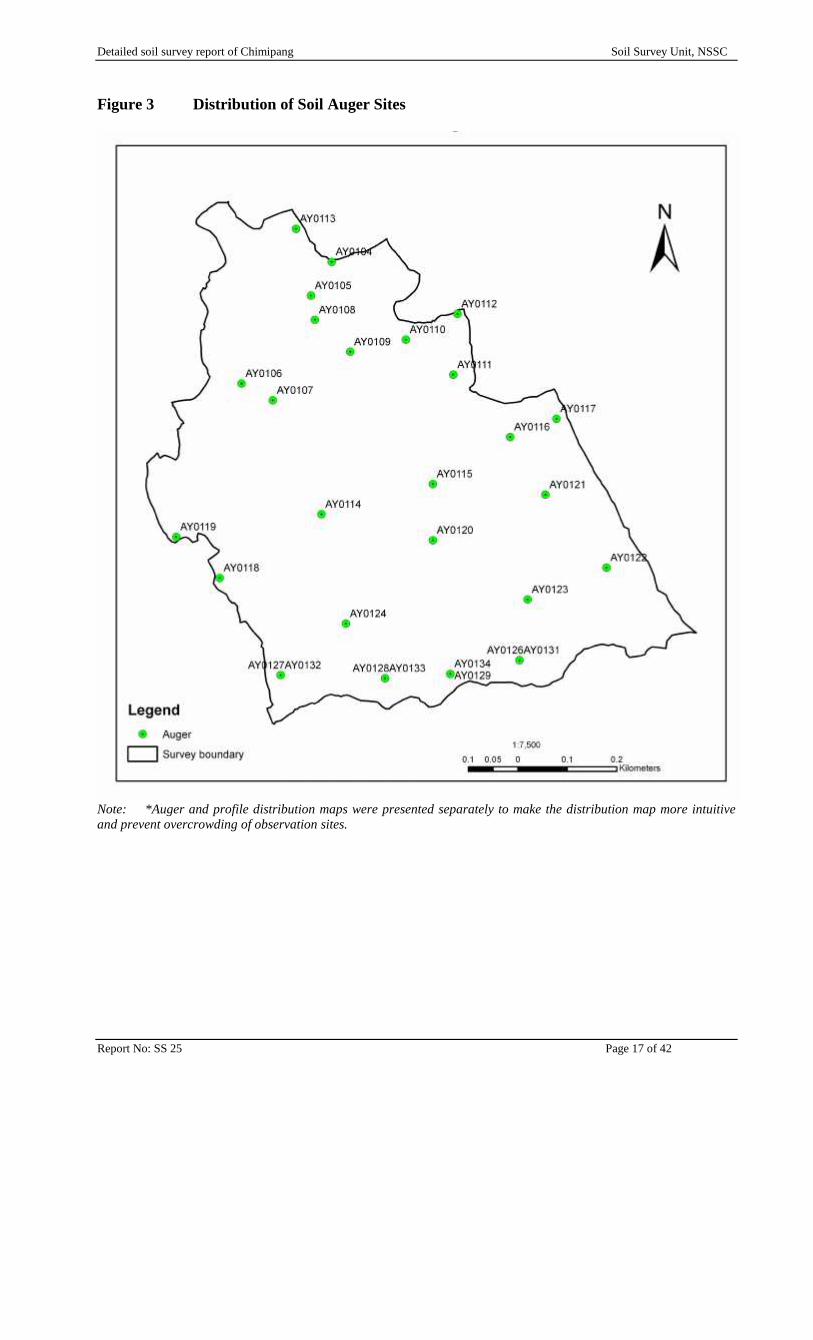
The fieldwork for this survey was carried out from 17th – 30th March, 2013. The soils wereexamined on a routine basis at 25 sites (Figure 3), mainly with a 1.2m Edelman auger, fitted with a7cm combination head where possible, but switching to a 7cm stony soil head where necessary.Soil profile pits were excavated based on the soils encountered during augering – in total, 14 soilprofile pits (Figure 4) were dug, described and sampled. All the routine observations were locatedbased on the differences in the landforms along transects at approximately 50 metres apart.
Under FAO, this survey would be classified as detailed with mapping scale of 1:7500 and thedensity of sites falling low to mid way on the FAO recommended scale (FAO includes“Minimum”, “Low”, “Mid” and “High” site density classes).
Detailed soil survey report of Chimipang Soil Survey Unit, NSSC
Report No: SS 25 Page 17 of 42
Figure 3 Distribution of Soil Auger Sites
Note: *Auger and profile distribution maps were presented separately to make the distribution map more intuitiveand prevent overcrowding of observation sites.
Detailed soil survey report of Chimipang Soil Survey Unit, NSSC
Report No: SS 25 Page 18 of 42
Figure 4 Distribution of Soil Profile Sites
Detailed soil survey report of Chimipang Soil Survey Unit, NSSC
Report No: SS 24 Page 19 of 42
3.2.2 Site Data
All data were collected on the SSU field description cards which have been specifically designed toenable uniform data collection for easy entry into the Bhutan Soil Databank (BHUSOD) system.For all soil observations the following site data were collected and noted along with several otherfeatures:
Site number, survey area name, topographic map and date of description Location, GPS coordinates, altitude, general topographic and site position Solid, or mapped geology and drift cover or parent material The gradient (in %), aspect and form of the slope with estimated run-off and site drainage Previous erosion and risk of flooding based on height above the nearest stream line Micro-relief, hardness of the surface, presence of capping or cracks Estimates (%) of outcropping rock plus stone or gravel cover and any surface litter (organic) General land use and current crops/vegetation and any known previous land uses Artificial land shaping features, irrigation type plus fertiliser use, if present or known.
3.2.3 Soil Data
All data were collected on the SSU field description cards which have been specifically designed toenable uniform data collection for easy entry into the Bhutan Soil Databank (BHUSOD) system.The cards for the auger descriptions are considerably smaller than those for the profile data sincemany soil features cannot be described while augering.
(a) Auger Sites
Auger samples were collected by withdrawing the auger each time the “head” was full of soil.Each sample was then laid in the ground next to the auger hole in order - each sample accountingfor approximately 10cm depth of the excavation. Surveyors could then easily determine the depthsat which changes in the soil occurred. The soils were described according to their natural layering(horizons), throughout the depth to which the auger reached, which at best, is just over 1 metre, andnot at fixed depths. The following data were collected for each horizon:
Horizon number, depth and type Munsell colour of matrix – dry and moist when conditions permit Number, size, contrast and colour of mottles Field texture including coarse material prefix and particle size class (PSC) Number, size, shape, hardness and type of stones Reaction to dilute hydrochloric acid (HCL) (to test for presence of free carbonate minerals) Number, size, shape, form type, hardness and colour of concentrations or concretions Field moisture status of the soil and, when possible, consistency and plasticity of each
horizon in dry, moist and wet condition.
Soil samples were collected from auger sites in addition to the samples from profile pits.
Detailed soil survey report of Chimipang Soil Survey Unit, NSSC
Report No: SS 24 Page 20 of 42
(b) Profile Pit Sites
The soils were described in more detail at fourteen sites. All the detailed descriptions were done inpurpose-dug profile pits. Profile pits were normally excavated to 150cm depth or to a limiting layersuch as solid rock or boulders. The site data were exactly the same as for the auger sites. The soilswere described by horizons according to international conventions (FAO 1990). The data collectedfor each horizon were the same as in the auger descriptions, with the addition of:
Whether the horizon was sampled for analyses Lithological layers if recognizable Clarity and shape of horizon boundaries Presence of any minerals Strength, size and type of soil structure Development, size, type, continuity and location of any coatings or cutans (shiny coatings
on surfaces of soil structural units) Number, size and type or shape of pores, Consistence in situ and in hand; Number size and type of roots Frequency and size of cracks Presence and artifacts or effects of fauna (worm casts etc.); Frequency, size type and orientation of roots.
All data were collected on purpose designed proforma which are computer compatible and alloweasy entry of the collected data into the BHUSOD system.
The main horizons of all of the profiles described in detail were sampled for chemical analysis.
3.3 Mapping
The survey site falls within the 1:50,000 topographic map sheet No. 78E14 of 2000 and contours at40m interval of the National Land Commission. This map scale is very small and is not suitable fordetailed site planning and also to use as a base map. Therefore, the soil survey team prepared a basemap at 1: 7500 scale using GPS and Ozi Explorer software.
3.3.1 Maps produced and used during the survey
The following maps were constructed in Arc GIS environment based on the NLC map sheet 78E14by the survey team and used or compiled during and after the survey.
Detailed soil survey report of Chimipang Soil Survey Unit, NSSC
Report No: SS 24 Page 21 of 42
Table 3 Maps Compiled and Used during the Survey
Map Scale Content and Use
Base map 1:7,500 Geographic registration coordinates, foot path, farm boundary and infrastructuraldetail
Auger and profiledistribution
1:7,500 Location of all sites described and located via GPS readings but checked aslocational accuracy in the field and via detail of the base and land unit maps
Soil Series 1:7,500 Shows the soil series number code for each site. Used for the construction of theactual soil map
Soil Map 1:7,500 Shows the boundaries between the various soil mapping units defined andmapped. Compiled by interpretation and integration of the soil series and landunits
Location Map 1: 40,000 Shows the position of the survey area with respect to other nearby places, roadsand water bodies
3.3.2 Final Map Presentation
Once all the draft maps were compiled and modified, it was then digitized using the GIS Software.The following maps were appended:
Location map Auger and profile distribution map Soil mapping unit Soil map and Soil series map
The final maps were produced at a scale of 1:7,500 and copies are appended in the report.
3.4 Laboratory
A total of 48 soil samples were collected from the main horizons of the 14 detailed profile pits andsubmitted for analysis by the Soil and Plant Analytical Laboratory (SPAL), NSSC at Semtokha.
3.5 Data Storage
As stated above all data were collected on the SSU computer compatible field data cards andsubsequently all the data were entered into the BHUSOD system for storage and data manipulation.
Detailed soil survey report of Chimipang Soil Survey Unit, NSSC
Report No: SS 24 Page 22 of 42
4. SOIL CLASSIFICATION, CHARACTERISTICS & CORRELATION
4.1 Soil Classification
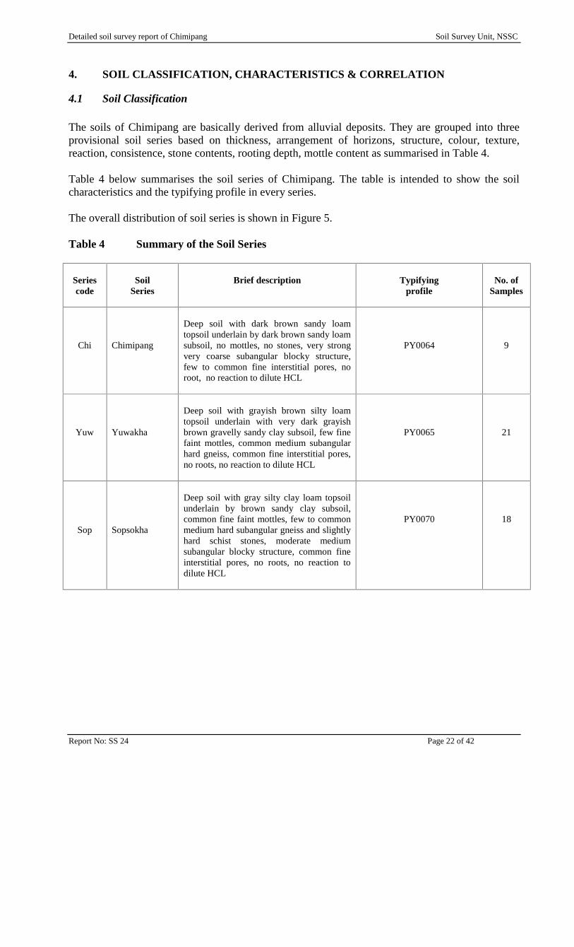
The soils of Chimipang are basically derived from alluvial deposits. They are grouped into threeprovisional soil series based on thickness, arrangement of horizons, structure, colour, texture,reaction, consistence, stone contents, rooting depth, mottle content as summarised in Table 4.
Table 4 below summarises the soil series of Chimipang. The table is intended to show the soilcharacteristics and the typifying profile in every series.
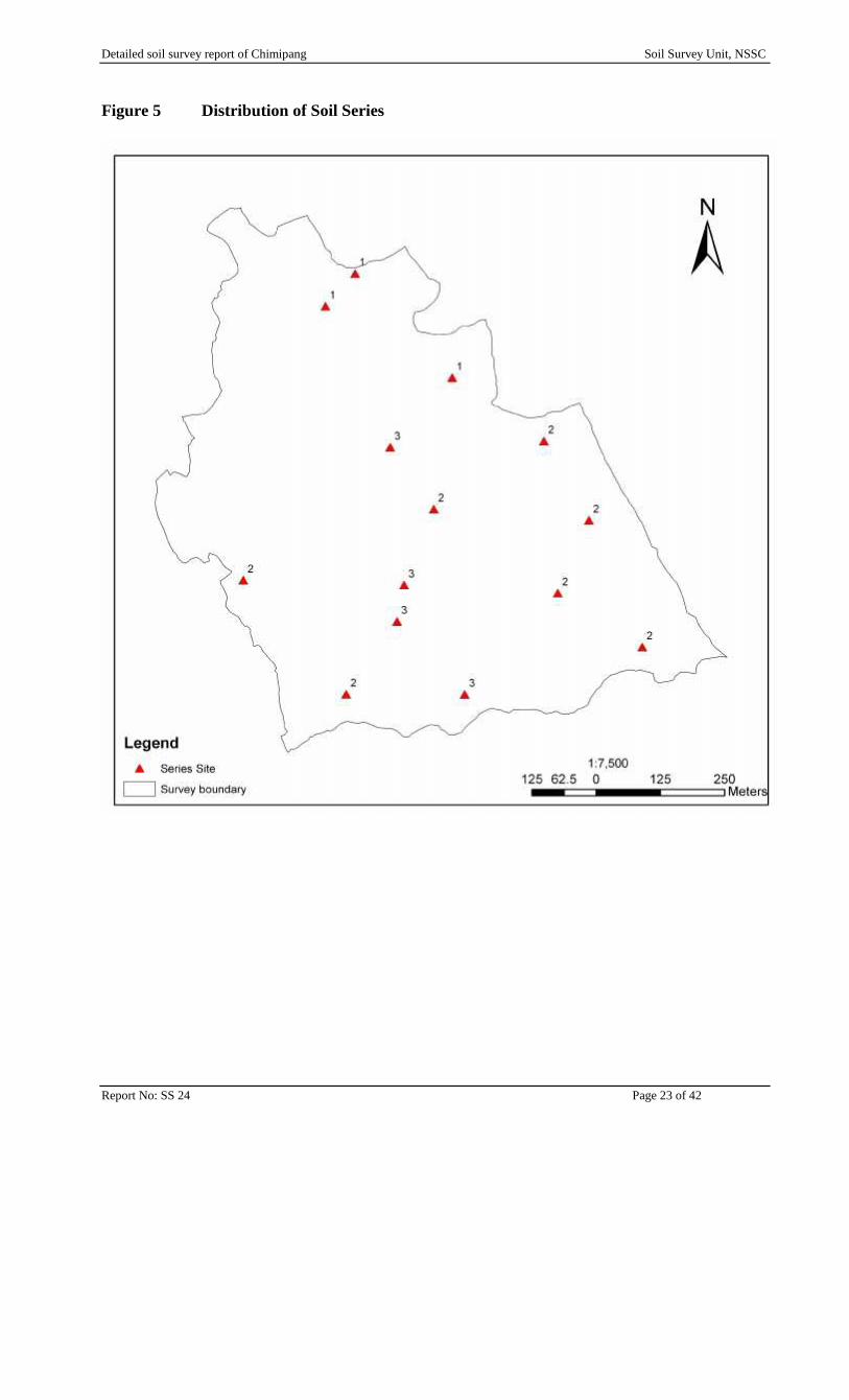
The overall distribution of soil series is shown in Figure 5.
Table 4 Summary of the Soil Series
Seriescode
SoilSeries
Brief description Typifyingprofile
No. ofSamples
Chi Chimipang
Deep soil with dark brown sandy loamtopsoil underlain by dark brown sandy loamsubsoil, no mottles, no stones, very strongvery coarse subangular blocky structure,few to common fine interstitial pores, noroot, no reaction to dilute HCL
PY0064 9
Yuw Yuwakha
Deep soil with grayish brown silty loamtopsoil underlain with very dark grayishbrown gravelly sandy clay subsoil, few finefaint mottles, common medium subangularhard gneiss, common fine interstitial pores,no roots, no reaction to dilute HCL
PY0065 21
Sop Sopsokha
Deep soil with gray silty clay loam topsoilunderlain by brown sandy clay subsoil,common fine faint mottles, few to commonmedium hard subangular gneiss and slightlyhard schist stones, moderate mediumsubangular blocky structure, common fineinterstitial pores, no roots, no reaction todilute HCL
PY0070 18
Detailed soil survey report of Chimipang Soil Survey Unit, NSSC
Report No: SS 24 Page 23 of 42
Figure 5 Distribution of Soil Series
Detailed soil survey report of Chimipang Soil Survey Unit, NSSC
Report No: SS 24 Page 24 of 42
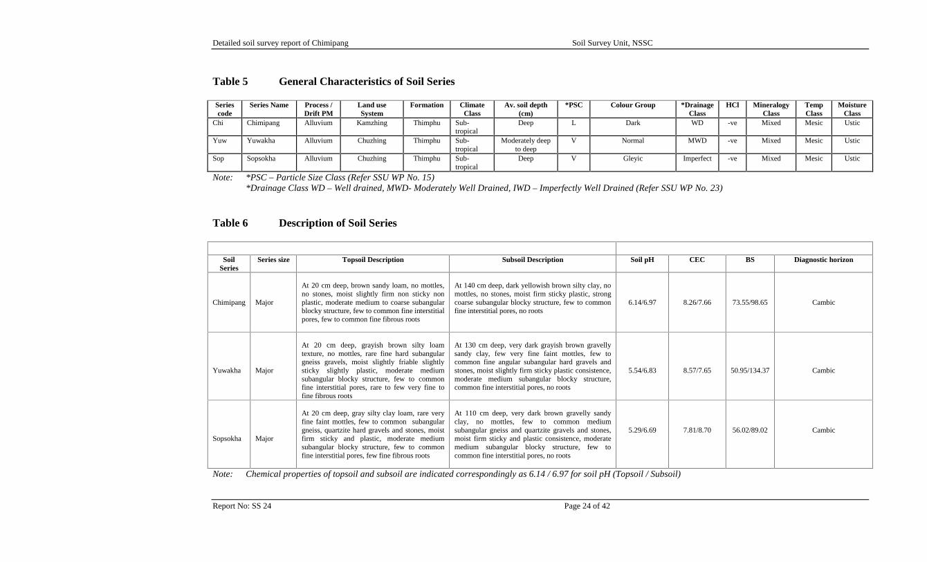
Table 5 General Characteristics of Soil Series
Seriescode
Series Name Process /Drift PM
Land useSystem
Formation ClimateClass
Av. soil depth(cm)
*PSC Colour Group *DrainageClass
HCl MineralogyClass
TempClass
MoistureClass
Chi Chimipang Alluvium Kamzhing Thimphu Sub-tropical
Deep L Dark WD -ve Mixed Mesic Ustic
Yuw Yuwakha Alluvium Chuzhing Thimphu Sub-tropical
Moderately deepto deep
V Normal MWD -ve Mixed Mesic Ustic
Sop Sopsokha Alluvium Chuzhing Thimphu Sub-tropical
Deep V Gleyic Imperfect -ve Mixed Mesic Ustic
Note: *PSC – Particle Size Class (Refer SSU WP No. 15)*Drainage Class WD – Well drained, MWD- Moderately Well Drained, IWD – Imperfectly Well Drained (Refer SSU WP No. 23)
Table 6 Description of Soil Series
SoilSeries
Series size Topsoil Description Subsoil Description Soil pH CEC BS Diagnostic horizon
Chimipang Major
At 20 cm deep, brown sandy loam, no mottles,no stones, moist slightly firm non sticky nonplastic, moderate medium to coarse subangularblocky structure, few to common fine interstitialpores, few to common fine fibrous roots
At 140 cm deep, dark yellowish brown silty clay, nomottles, no stones, moist firm sticky plastic, strongcoarse subangular blocky structure, few to commonfine interstitial pores, no roots
6.14/6.97 8.26/7.66 73.55/98.65 Cambic
Yuwakha Major
At 20 cm deep, grayish brown silty loamtexture, no mottles, rare fine hard subangulargneiss gravels, moist slightly friable slightlysticky slightly plastic, moderate mediumsubangular blocky structure, few to commonfine interstitial pores, rare to few very fine tofine fibrous roots
At 130 cm deep, very dark grayish brown gravellysandy clay, few very fine faint mottles, few tocommon fine angular subangular hard gravels andstones, moist slightly firm sticky plastic consistence,moderate medium subangular blocky structure,common fine interstitial pores, no roots
5.54/6.83 8.57/7.65 50.95/134.37 Cambic
Sopsokha Major
At 20 cm deep, gray silty clay loam, rare veryfine faint mottles, few to common subangulargneiss, quartzite hard gravels and stones, moistfirm sticky and plastic, moderate mediumsubangular blocky structure, few to commonfine interstitial pores, few fine fibrous roots
At 110 cm deep, very dark brown gravelly sandyclay, no mottles, few to common mediumsubangular gneiss and quartzite gravels and stones,moist firm sticky and plastic consistence, moderatemedium subangular blocky structure, few tocommon fine interstitial pores, no roots
5.29/6.69 7.81/8.70 56.02/89.02 Cambic
Note: Chemical properties of topsoil and subsoil are indicated correspondingly as 6.14 / 6.97 for soil pH (Topsoil / Subsoil)
Detailed soil survey report of Chimipang Soil Survey Unit, NSSC
Report No: SS 24 Page 25 of 42
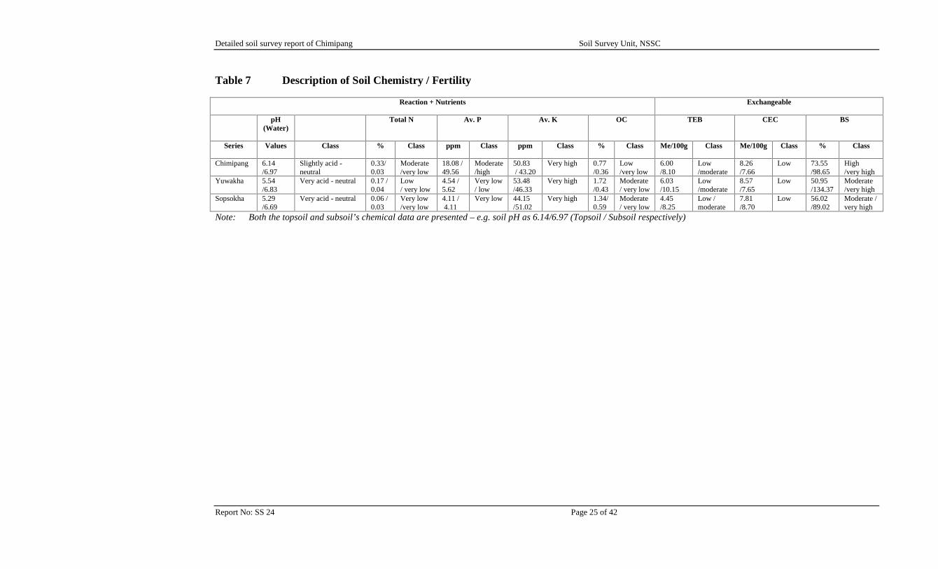
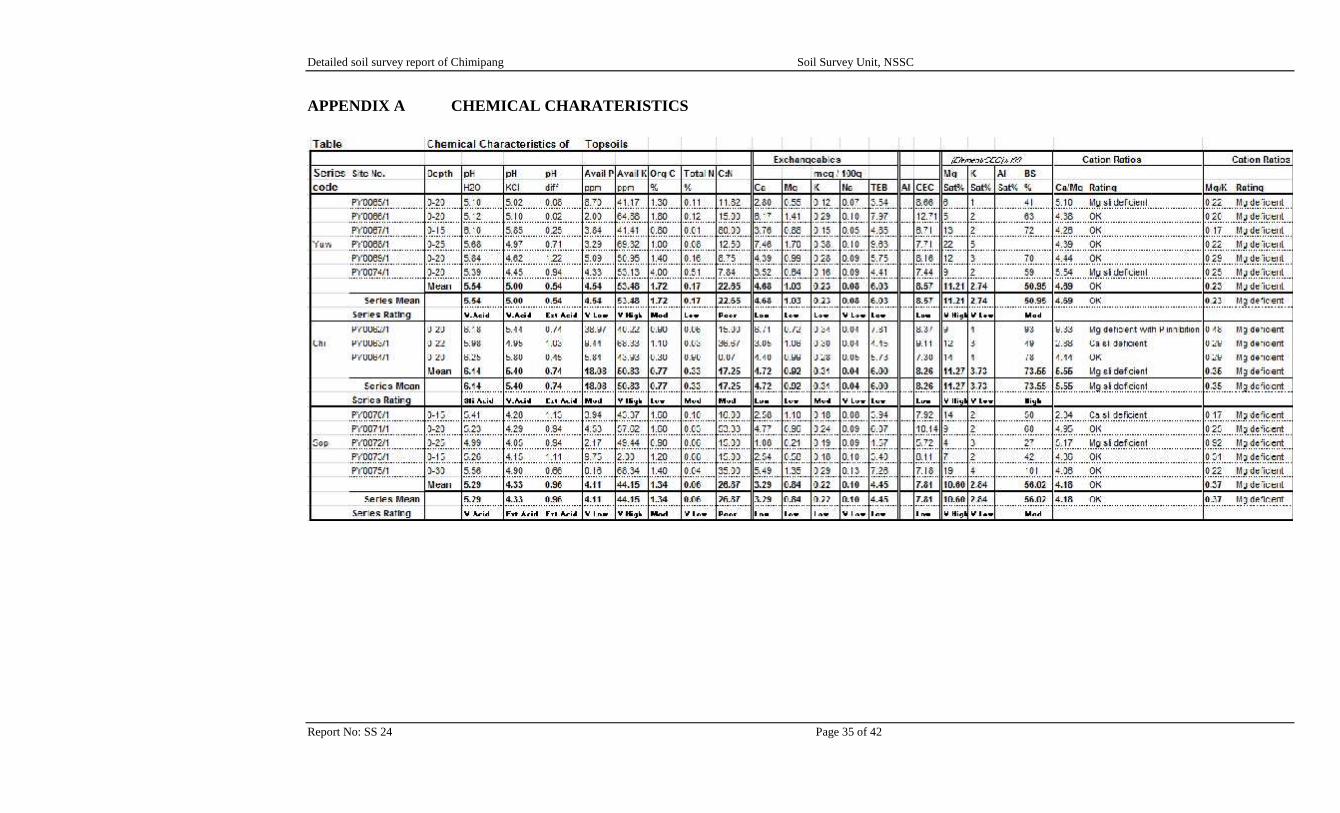
Table 7 Description of Soil Chemistry / Fertility
Reaction + Nutrients Exchangeable
pH(Water)
Total N Av. P Av. K OC TEB CEC BS
Series Values Class % Class ppm Class ppm Class % Class Me/100g Class Me/100g Class % Class
Chimipang 6.14/6.97
Slightly acid -neutral
0.33/0.03
Moderate/very low
18.08 /49.56
Moderate/high
50.83/ 43.20
Very high 0.77/0.36
Low/very low
6.00/8.10
Low/moderate
8.26/7.66
Low 73.55/98.65
High/very high
Yuwakha 5.54/6.83
Very acid - neutral 0.17 /0.04
Low/ very low
4.54 /5.62
Very low/ low
53.48/46.33
Very high 1.72/0.43
Moderate/ very low
6.03/10.15
Low/moderate
8.57/7.65
Low 50.95/134.37
Moderate/very high
Sopsokha 5.29/6.69
Very acid - neutral 0.06 /0.03
Very low/very low
4.11 /4.11
Very low 44.15/51.02
Very high 1.34/0.59
Moderate/ very low
4.45/8.25
Low /moderate
7.81/8.70
Low 56.02/89.02
Moderate /very high
Note: Both the topsoil and subsoil’s chemical data are presented – e.g. soil pH as 6.14/6.97 (Topsoil / Subsoil respectively)
Detailed soil survey report of Chimipang Soil Survey Unit, NSSC
Report No: SS 24 Page 26 of 42
4.2 Soil Fertility Status
This section aims to present an overall picture of the soils studied in the survey area.
4.2.1 Soil Reaction
The topsoil is slightly acid to very acid with pH values between 6.14 – 5.29. The soil pH in thesubsoil is neutral, indicating perfect pH range for growing any crops. However, some liming mightbe required for very sensitive crops but present calculations indicate only around 1-2 tons/ acremight be required to counteract the effects of acidity (Fertilizer guide, 2013), if application of limeis considered.
4.2.2 Inherent Fertility
Inherent, or existing, fertility is measured by the levels of exchangeable cations, total exchangeablebases, base saturation and levels of organic carbon, total nitrogen and available phosphate. Thephosphorous level in the topsoil is low with average value 8.91 ppm and moderate in the subsoilwith 19.76 ppm. The available potassium in both the topsoil and subsoil is very high (43.20 – 53.48ppm). Topsoils are rated as having moderate level of organic carbon with C:N ratios rated as poor.The subsoils have very low levels of organic carbon with good C:N ratio. Study of the variousratios of Ca:Mg and Mg:K indicate that there are some imbalances and possible deficiencies ofnutrients – in particular Mg in the topsoil and subsoil respectively. The low to moderate levels oftotal exchangeable bases plus the cation ratios indicate the need for addition of fertilizer or FYM -refer Appendix A.
4.2.3 Fertility Potential
Fertility potential, or the ability of the soil to retain any added nutrients rather than allow them to beleached out, is assessed by the cation exchange capacity (CEC) of the soil. Overall the soils in thisarea all have low fertility potential as evidenced by low CEC. CEC is all rated as low in bothtopsoils and subsoils with average values of 8.21 and 8.00 me/100g. Fertility potential could beimproved by the application and or incorporation of FYM.
Overall, application of FYM would improve the existing fertility status and improve the fertilitypotential.
4.3 Soil Correlation
4.3.1 Previous Survey
In order to see how Chimipang soils fit into a wider context, it is necessary to correlate them withsoils elsewhere in Bhutan and also with the international system of soil classification.
From many of the soil surveys carried out in Bhutan, the detailed soil survey at RNR-DC in Bajo,Lingmutey Chhu Watershed and Nyakalumpa valley soils were taken for correlation. This isbecause the soils of above areas lie in the same valley under similar landform, within same geologyand climatic conditions.
Detailed soil survey report of Chimipang Soil Survey Unit, NSSC
Report No: SS 24 Page 27 of 42
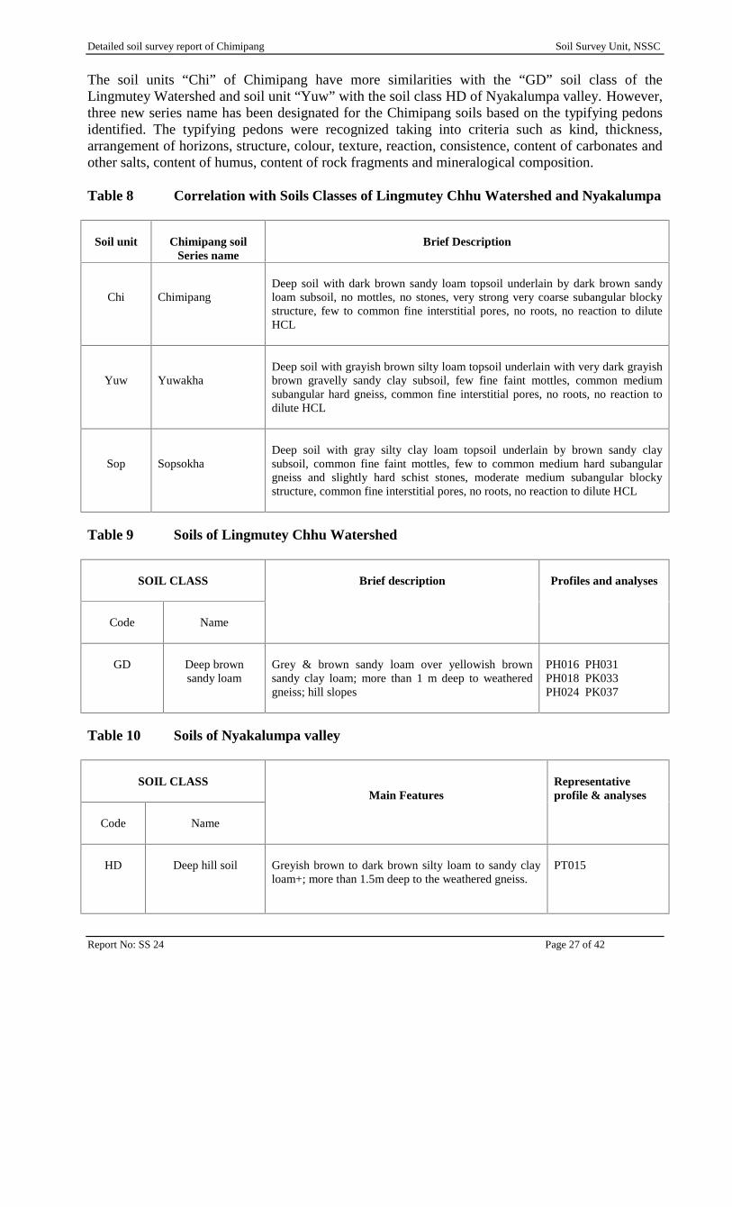
The soil units “Chi” of Chimipang have more similarities with the “GD” soil class of theLingmutey Watershed and soil unit “Yuw” with the soil class HD of Nyakalumpa valley. However,three new series name has been designated for the Chimipang soils based on the typifying pedonsidentified. The typifying pedons were recognized taking into criteria such as kind, thickness,arrangement of horizons, structure, colour, texture, reaction, consistence, content of carbonates andother salts, content of humus, content of rock fragments and mineralogical composition.
Table 8 Correlation with Soils Classes of Lingmutey Chhu Watershed and Nyakalumpa
Soil unit Chimipang soilSeries name
Brief Description
Chi ChimipangDeep soil with dark brown sandy loam topsoil underlain by dark brown sandyloam subsoil, no mottles, no stones, very strong very coarse subangular blockystructure, few to common fine interstitial pores, no roots, no reaction to diluteHCL
Yuw YuwakhaDeep soil with grayish brown silty loam topsoil underlain with very dark grayishbrown gravelly sandy clay subsoil, few fine faint mottles, common mediumsubangular hard gneiss, common fine interstitial pores, no roots, no reaction todilute HCL
Sop SopsokhaDeep soil with gray silty clay loam topsoil underlain by brown sandy claysubsoil, common fine faint mottles, few to common medium hard subangulargneiss and slightly hard schist stones, moderate medium subangular blockystructure, common fine interstitial pores, no roots, no reaction to dilute HCL
Table 9 Soils of Lingmutey Chhu Watershed
SOIL CLASS Brief description Profiles and analyses
Code Name
GD Deep brownsandy loam
Grey & brown sandy loam over yellowish brownsandy clay loam; more than 1 m deep to weatheredgneiss; hill slopes
PH016 PH031PH018 PK033PH024 PK037
Table 10 Soils of Nyakalumpa valley
SOIL CLASSMain Features
Representativeprofile & analyses
Code Name
HD Deep hill soil Greyish brown to dark brown silty loam to sandy clayloam+; more than 1.5m deep to the weathered gneiss.
PT015
Detailed soil survey report of Chimipang Soil Survey Unit, NSSC
Report No: SS 24 Page 28 of 42
4.3.2 International Correlations
The series names are not useful to soil scientists outside Bhutan. For them it is necessary to give theequivalents in the international systems of soil classification. At present SSU correlates its soilseries with the systems of FAO and the US Department of Agriculture. Table 11 correlates the soilseries with the 1998 version of the FAO World Reference Base for Soil Resources, and with the2nd edition (1999) of the USDA Soil Taxonomy.
Because full and definite correlations require somewhat detailed and extensive laboratory andenvironmental data, which are not available for the soils of Chimipang, the correlations in Table 11are just an approximate. The Soil Moisture Regime (SMR) is assigned as udic and the SoilTemperature Regime (STR) is clearly mesic as the mean annual temperature is lower than 22ºC anddifference between mean summer and mean winter temperature more than 6ºC. The Particle SizeClasses (PSC) is M and V.
The soils at Chimipang are classified as Cambisols (WRB) and Inceptisols (USDA), since there isvery limited soil development as the soils are relatively young compared to other soils around theworld and or since it is considered that the development of the soil structure, often associated withcolour changes, qualify as cambic horizon.
Detailed soil survey report of Chimipang Soil Survey Unit, NSSC
Report No: SS 24 Page 29 of 42
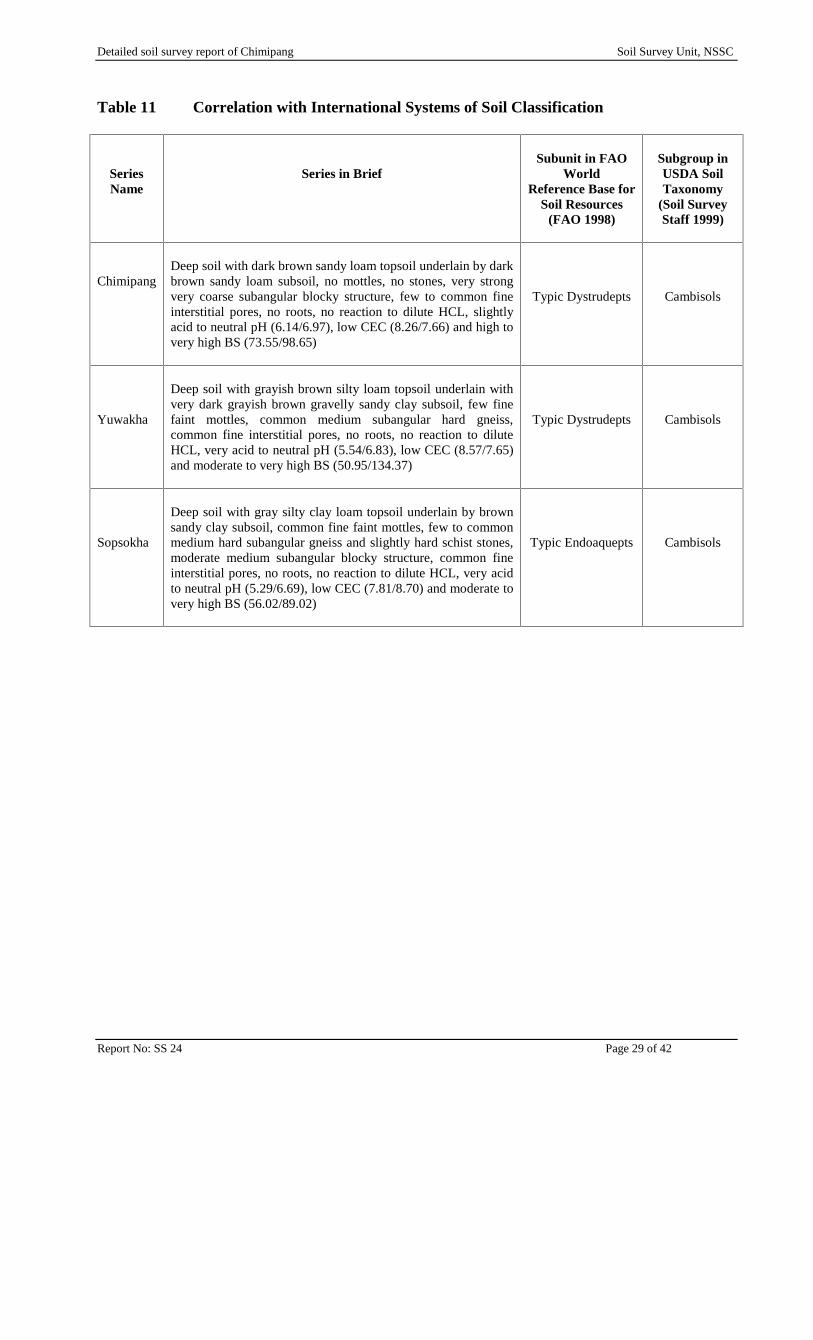
Table 11 Correlation with International Systems of Soil Classification
SeriesName
Series in BriefSubunit in FAO
WorldReference Base for
Soil Resources(FAO 1998)
Subgroup inUSDA SoilTaxonomy
(Soil SurveyStaff 1999)
ChimipangDeep soil with dark brown sandy loam topsoil underlain by darkbrown sandy loam subsoil, no mottles, no stones, very strongvery coarse subangular blocky structure, few to common fineinterstitial pores, no roots, no reaction to dilute HCL, slightlyacid to neutral pH (6.14/6.97), low CEC (8.26/7.66) and high tovery high BS (73.55/98.65)
Typic Dystrudepts Cambisols
Yuwakha
Deep soil with grayish brown silty loam topsoil underlain withvery dark grayish brown gravelly sandy clay subsoil, few finefaint mottles, common medium subangular hard gneiss,common fine interstitial pores, no roots, no reaction to diluteHCL, very acid to neutral pH (5.54/6.83), low CEC (8.57/7.65)and moderate to very high BS (50.95/134.37)
Typic Dystrudepts Cambisols
Sopsokha
Deep soil with gray silty clay loam topsoil underlain by brownsandy clay subsoil, common fine faint mottles, few to commonmedium hard subangular gneiss and slightly hard schist stones,moderate medium subangular blocky structure, common fineinterstitial pores, no roots, no reaction to dilute HCL, very acidto neutral pH (5.29/6.69), low CEC (7.81/8.70) and moderate tovery high BS (56.02/89.02)
Typic Endoaquepts Cambisols
Detailed soil survey report of Chimipang Soil Survey Unit, NSSC
Report No: SS 24 Page 30 of 42
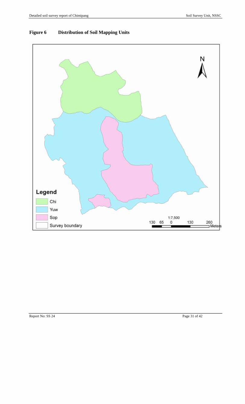
5. SOIL DISTRIBUTION AND MAPPING
5.1 Soil Distribution
There are three map units covering the entire survey area and each map unit is relatively pure inthat the soils are quite uniform within each unit.
The map units were defined in the field and office on noted correlations between topography andsoil observations. The features on the topographic map were used to draw the boundaries of themap units – normally boundaries would be drawn with the aid of aerial photographs but nophotographs or photographs of suitable scale were located.
Majority of the soil series are dominated by the sandy to silty loam (SL, ZL) and sandy clay (SC)textures, with particle size class (PSC) of “M” and “V”.
Figure 6 shows the distribution of soil mapping units. The soils under each mapping units with theirchemical properties are discussed briefly in Table 13.
5.2 Soil Mapping Units
All the soils are mapped as consociation. The mapping units are summarised in Table 12 in termsof type, series type and their respective areas etc.
Table 12 Composition and Extent of Soil Mapping Units
Map unit Type Main soilseries
Minor soilseries
ExtentsHa Acres %
Chi Consociation Chimipang - 14.35 35.46 21.81
Yuw Consociation Yuwakha - 39.05 96.5 59.37
Sop Consociation Sopsokha - 12.38 30.59 18.82Total 65.78 162.55 100
Detailed soil survey report of Chimipang Soil Survey Unit, NSSC
Report No: SS 24 Page 31 of 42
Figure 6 Distribution of Soil Mapping Units
Detailed soil survey report of Chimipang Soil Survey Unit, NSSC
Report No: SS 24 Page 32 of 42
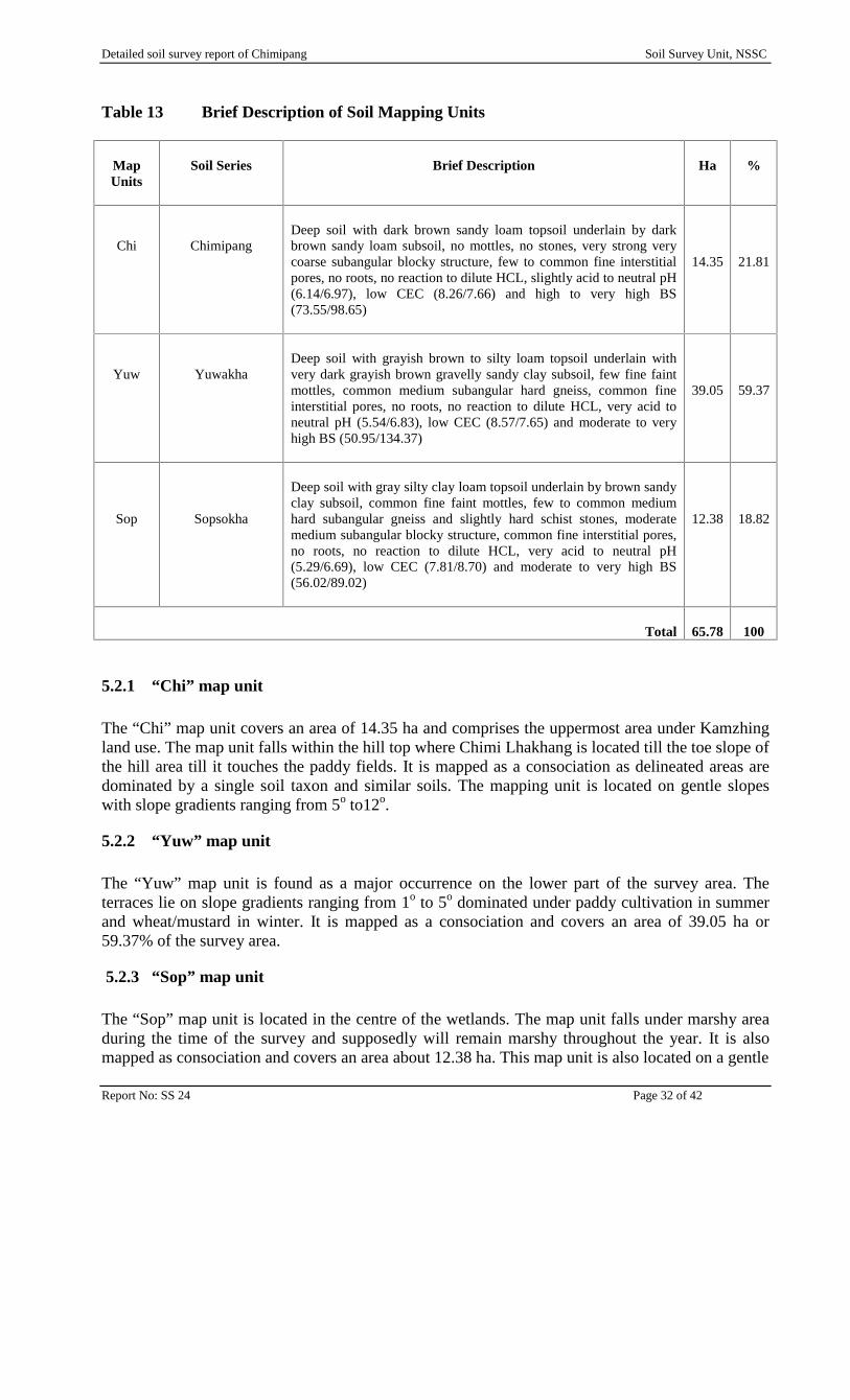
Table 13 Brief Description of Soil Mapping Units
MapUnits
Soil Series Brief Description Ha %
Chi ChimipangDeep soil with dark brown sandy loam topsoil underlain by darkbrown sandy loam subsoil, no mottles, no stones, very strong verycoarse subangular blocky structure, few to common fine interstitialpores, no roots, no reaction to dilute HCL, slightly acid to neutral pH(6.14/6.97), low CEC (8.26/7.66) and high to very high BS(73.55/98.65)
14.35 21.81
Yuw YuwakhaDeep soil with grayish brown to silty loam topsoil underlain withvery dark grayish brown gravelly sandy clay subsoil, few fine faintmottles, common medium subangular hard gneiss, common fineinterstitial pores, no roots, no reaction to dilute HCL, very acid toneutral pH (5.54/6.83), low CEC (8.57/7.65) and moderate to veryhigh BS (50.95/134.37)
39.05 59.37
Sop Sopsokha
Deep soil with gray silty clay loam topsoil underlain by brown sandyclay subsoil, common fine faint mottles, few to common mediumhard subangular gneiss and slightly hard schist stones, moderatemedium subangular blocky structure, common fine interstitial pores,no roots, no reaction to dilute HCL, very acid to neutral pH(5.29/6.69), low CEC (7.81/8.70) and moderate to very high BS(56.02/89.02)
12.38 18.82
Total 65.78 100
5.2.1 “Chi” map unit
The “Chi” map unit covers an area of 14.35 ha and comprises the uppermost area under Kamzhingland use. The map unit falls within the hill top where Chimi Lhakhang is located till the toe slope ofthe hill area till it touches the paddy fields. It is mapped as a consociation as delineated areas aredominated by a single soil taxon and similar soils. The mapping unit is located on gentle slopeswith slope gradients ranging from 5o to12o.
5.2.2 “Yuw” map unit
The “Yuw” map unit is found as a major occurrence on the lower part of the survey area. Theterraces lie on slope gradients ranging from 1o to 5o dominated under paddy cultivation in summerand wheat/mustard in winter. It is mapped as a consociation and covers an area of 39.05 ha or59.37% of the survey area.
5.2.3 “Sop” map unit
The “Sop” map unit is located in the centre of the wetlands. The map unit falls under marshy areaduring the time of the survey and supposedly will remain marshy throughout the year. It is alsomapped as consociation and covers an area about 12.38 ha. This map unit is also located on a gentle
Detailed soil survey report of Chimipang Soil Survey Unit, NSSC
Report No: SS 24 Page 33 of 42
slope with gradients ranging from 1o to 5o) and generally have easterly aspect. The site is dominatedunder paddy cultivation in summer and left fallow during winter.
6. OVERVIEW AND IMPLICATIONS
6.1 Overview of the Soils
The Chimipang survey area has a limited range of soils, on account of the small size of the area andhomogeneous geology. The soils are slightly acid to very acid with pH values less than 5.54 in thetopsoil and neutral pH with value less than 6.83 in the subsoil. The organic carbon content is low tomoderate in the topsoil and very low in the subsoil, while total nitrogen is low to very low. There isMagnesium deficiency in both the topsoil and subsoil.
The main differences in Chimipang soils relate to their physical properties. There are differences intexture of fine earth fractions. Texture in the topsoil varies from sandy loam to silty loam and sandyloam to sandy clay in the subsoil formed mainly due to the interplay of the mixed geology. The soilprofile excavation indicated that the soils depths are deep to deep (110 cm - 140 cm).
There are mainly three types of soils series recognized namely Chimipang, Yuwakha andSopsokha. The series were recognized based on the typifying pedons identified.
Detailed soil survey report of Chimipang Soil Survey Unit, NSSC
Report No: SS 24 Page 34 of 42
7. RECOMMENDATIONS
Based on the physical and chemical characteristics of the soils, following recommendations aresuggested to improve the soil nutrient status of the site.
The soil pH is slightly acid to very acid in the topsoil. Based on the soil pH requirement bydifferent plants, the soil needs to be ameliorated, either by raising the pH through incorporationof lime or reducing the pH by adding sphagnum peat, acidifying fertilizers2 and organicmulches. This is to bring soil pH to a desirable range, where nutrients are easily available foruptake by the plants. Most agronomic crops grow well within moderate pH range and flowers inslightly acid to acid soils.
Nitrogen is the other primary nutrient needed by plants in larger quantities. The N content iswithin low to very low range, demanding addition of urea or ammonium nitrate fertilizer.
The CEC of the soil samples is low in range and this could be improved by incorporating welldecomposed FYM and other organic materials.
There is Mg deficiency and this could be improved by applying dolomite, which is a goodsource of calcium (Ca) and magnesium (Mg).
2 Acidifying fertilizers such as ammonium sulfate, urea, and ammonium nitrate
Detailed soil survey report of Chimipang Soil Survey Unit, NSSC
Report No: SS 24 Page 35 of 42
APPENDIX A CHEMICAL CHARATERISTICS
Detailed soil survey report of Chimipang Soil Survey Unit, NSSC
Report No: SS 24 Page 36 of 42
Detailed soil survey report of Chimipang Soil Survey Unit, NSSC
Report No: SS 24 Page 37 of 42
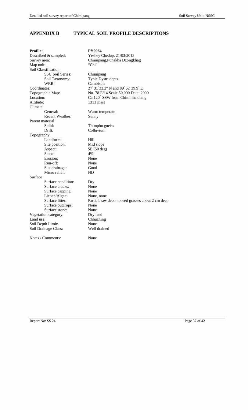
APPENDIX B TYPICAL SOIL PROFILE DESCRIPTIONS
Profile: PY0064Described & sampled: Yeshey Chedup, 21/03/2013Survey area: Chimipang,Punakha DzongkhagMap unit: “Chi”Soil Classification
SSU Soil Series: ChimipangSoil Taxonomy: Typic DystrudeptsWRB: Cambisols
Coordinates: 27º 31' 32.2" N and 89º 52' 39.9" ETopographic Map: No. 78 E/14 Scale 50,000 Date: 2000Location: Ca 120 º SSW from Chimi lhakhangAltitude: 1313 maslClimate
General: Warm temperateRecent Weather: Sunny
Parent materialSolid: Thimphu gneissDrift: Colluvium
TopographyLandform: HillSite position: Mid slopeAspect: SE (50 deg)Slope: 4%Erosion: NoneRun-off: NoneSite drainage: GoodMicro relief: ND
SurfaceSurface condition: DrySurface cracks: NoneSurface capping: NoneLichen/Algae: None, noneSurface litter: Partial, raw decomposed grasses about 2 cm deepSurface outcrops: NoneSurface stone: None
Vegetation category: Dry landLand use: ChhuzhingSoil Depth Limit: NoneSoil Drainage Class: Well drained
Notes / Comments: None
Detailed soil survey report of Chimipang Soil Survey Unit, NSSC
Report No: SS 24 Page 38 of 42
Cm Horizon Description
0-20 ApDark brown (10YR3/3) dry; sandy loam with no mottles; hard dry; moderatemedium angular and sub angular structure; common fine interstitial pores; few finefibrous and irregular roots; nil reaction to dilute HCL; clear and smooth boundary:[Sample No. PY0064/1]
20-110 BwDark brown (10YR3/3) moist; sandy loam with no mottles; none course materials;friable, friable non sticky and non plastic; weak medium granular structure;common fine interstitial pores; few fine fibrous and irregular roots; nil reaction todilute HCL; clear and smooth boundary: [Sample No. PY0064/2]
110-140 Bw1Dark yellowish brown (10YR 4/4) moist; silt clay with no mottles; no stone;content; moderate medium slightly sticky and slightly plastic; moderate mediumangular and sub angular structure; few fine tubular pores; few very fine fibrousroots; nil reaction to dilute HCL: [Sample No. PY0064/3]
Reaction + Nutrients
BSS No. Depthcm
LabNo.
pHWater
pHKCL
pHDiff
Avail-P ppm
OC % Total-N C:NRatio
Avail-Kppm
PY0064/1 0-20 46640 6.25 5.80 0.45 5.84 0.90 0.07 0.07 43.93PY0064/2 20-110 46641 7.12 5.30 1.82 9.71 0.02 0.01 19.76 36.33PY0064/3 110-140 46642 6.99 5.63 1.36 9.91 0.02 0.04 4.90 32.98
Exchangeables
BSS No. Exch CaMe/100g
Exch- mgMe/100g
Exch-KMe/100g
Exch-NaMe/100g
TEBMe/100g
CECAmOAcMe/100g
ECECMe/100g
BS%
PY0064/1 4.40 0.99 0.28 0.05 5.73 7.30 5.73 78.45PY0064/2 3.77 1.08 0.16 0.15 5.16 6.01 5.16 85.82PY0064/3 4.17 1.38 0.25 0.30 6.09 8.71 6.09 69.94
Detailed soil survey report of Chimipang Soil Survey Unit, NSSC
Report No: SS 24 Page 39 of 42
Profile: PY0065Described & sampled: Yeshey Chedup, 23/03/2013Survey area: Chimipang, Punakha DzongkhagMap unit: “Yuw”Soil Classification
SSU Soil Series: YuwakhaSoil Taxonomy: Typic DystrudeptsWRB: Cambisols
Coordinates: 27º 31' 12.4" N and 89º 52' 32.00" ETopographic Map: No. 78 E/14 Scale 50,000 Date: 2000Location: NRAltitude: 1289 maslClimate
General: Warm temperateRecent Weather: Sunny
Parent materialSolid: Thimphu gneissDrift: Colluvium
TopographyLandform: ValleySite position: Lower slopeAspect: NW (40 deg)Slope: 3%Erosion: NoneRun-off: NoneSite drainage: GoodMicro relief: ND
SurfaceSurface condition: Slightly moistSurface cracks: NoneSurface capping: NoneLichen/Algae: None, noneSurface litter: Partial, raw decomposed grasses about 1 cm deepSurface outcrops: NoneSurface stone: Rare (1%), fine, subangular gneiss and schist stones
Vegetation category: Dry landLand use: ChhuzhingSoil Depth Limit: NoneSoil Drainage Class: Well drained
Notes / Comments: None
Detailed soil survey report of Chimipang Soil Survey Unit, NSSC
Report No: SS 24 Page 40 of 42
Cm Horizon Description
0-20 ApGrayish brown (10YR 5/2) moist; silt loam with common fine prominent mottles;few (2%) fine hard angular and sub angular gneiss and schist; slightly moist friableslightly sticky slightly plastic; moderate medium angular and sub angular structure;common fine tubular pores; many fine medium fibrous and irregular roots; nilreaction to dilute HCL; clear and smooth boundary: [Sample No. PY0065/1]
20-50 BwDark grayish brown (10YR 4/2) moist; sandy loam with few fine prominent mottles(5YR6/8); common (15%) fine medium hard subangular gneiss and schist stones;friable, non sticky and non plastic; strong coarse to very coarse subangular blockystructure; common very fine tubular pores; rare very fine fibrous roots; nil reactionto dilute HCL; abrupt and smooth boundary: [Sample No. PY0065/2]
50-80 Bw1Very dark grayish brown (10YR 3/2) moist; gravelly sandy clay loam with fewfine prominent mottles (5YR6/8); common (15%) fine medium hard subangulargneiss and schist stones; friable, sticky and plastic; medium coarse sub angularand angular blocky structure; many fine tubular pores; rare very fine fibrous roots;nil reaction to dilute HCL: [Sample No. PY0065/3]
80-130 Bw2Very dark grayish brown (10YR 3/2) moist; gravelly sandy clay loam with fewfine prominent mottles (5YR6/8); common (15%) fine medium hard sub angulargneiss and schist stones; friable, sticky and plastic; fine medium coarse sub angularand angular blocky structure; many fine tubular pores; no roots; nil reaction todilute HCL: [Sample No. PY0065/4]
Reaction + Nutrients
BSS No. Depthcm
LabNo.
pHWater
pHKCL
pHDiff
Avail-P ppm
OC % Total-N C:NRatio
Avail-Kppm
PY0065/1 0-20 46643 5.10 5.02 0.08 8.70 1.30 0.11 11.66 41.17PY0065/2 20-50 46644 6.48 4.03 2.45 3.31 0.30 0.04 7.37 32.88PY0065/3 50-80 46645 6.61 5.01 1.60 12.83 0.50 0.06 8.20 43.48PY0065/4 80-130 46646 6.76 4.90 1.86 0.40 0.02 19.70 49.84
Exchangeables
BSS No. Exch CaMe/100g
Exch- mgMe/100g
Exch-KMe/100g
Exch-NaMe/100g
TEBMe/100g
CECAmOAcMe/100g
ECECMe/100g
BS%
PY0065/1 2.80 0.55 0.12 0.07 3.54 8.66 5.16 40.85PY0065/2 3.18 0.73 0.14 0.12 4.17 5.49 4.17 75.95PY0065/3 6.11 1.13 0.28 0.05 7.58 6.79 7.58 111.68PY0065/4 5.74 1.15 0.29 0.07 7.26 7.99 7.26 90.88
Detailed soil survey report of Chimipang Soil Survey Unit, NSSC
Report No: SS 24 Page 41 of 42
Profile: PY0070Described & sampled: Yeshey Chedup, 25/03/2013Survey area: ChimipangMap unit: “Sopsokha”Soil Classification
SSU Soil Series: SopsokhaSoil Taxonomy: Typic EndoaqueptsWRB: Cambisols
Coordinates: 27º 31' 09.9" N and 89º 52' 42.9" ETopographic Map: No. 78 E/14 Scale 50,000 Date: 2000Location:Altitude: 1262 maslClimate
General: Warm temperateRecent Weather: Sunny
Parent materialSolid: Thimphu gneissDrift: Colluvium
TopographyLandform: ValleySite position: Lower slopeAspect: E (90 deg)Slope: 2%Erosion: NoneRun-off: NoneSite drainage: GoodMicro relief: ND
SurfaceSurface condition: Slightly moistSurface cracks: NoneSurface capping: NoneLichen/Algae: None, noneSurface litter: Sparse, raw decomposed grasses and straw about 1 cm deepSurface outcrops: NoneSurface stone: None
Vegetation category: ChhuzhingLand use: ChhuzhingSoil Depth Limit: NoneSoil Drainage Class: Well drained
Notes / Comments: None
Detailed soil survey report of Chimipang Soil Survey Unit, NSSC
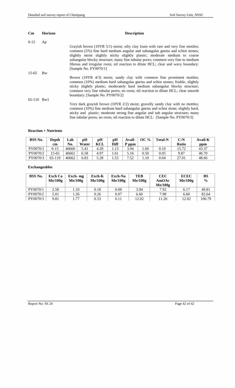
Report No: SS 24 Page 42 of 42
Cm Horizon Description
0-15 ApGrayish brown (10YR 5/1) moist; silty clay loam with rare and very fine mottles;common (5%) fine hard medium angular and subangular gneiss and schist stones;slightly moist slightly sticky slightly plastic; moderate medium to coarsesubangular blocky structure; many fine tubular pores; common very fine to mediumfibrous and irregular roots; nil reaction to dilute HCL; clear and wavy boundary:[Sample No. PY0070/1]
15-65 BwBrown (10YR 4/3) moist; sandy clay with common fine prominent mottles;common (10%) medium hard subangular gneiss and schist stones; friable, slightlysticky slightly plastic; moderately hard medium subangular blocky structure;common very fine tubular pores; no roots; nil reaction to dilute HCL; clear smoothboundary: [Sample No. PY0070/2]
65-110 Bw1Very dark grayish brown (10YR 2/2) moist; gravelly sandy clay with no mottles;common (10%) fine medium hard subangular gneiss and schist stone; slightly hard,sticky and plastic; moderate strong fine angular and sub angular structure; manyfine tubular pores; no roots; nil reaction to dilute HCL: [Sample No. PY0070/3]
Reaction + Nutrients
BSS No. Depthcm
LabNo.
pHWater
pHKCL
pHDiff
Avail-P ppm
OC % Total-N C:NRatio
Avail-Kppm
PY0070/1 0-15 46660 5.41 4.28 1.13 3.94 1.60 0.10 15.72 43.37PY0070/2 15-65 46661 6.58 4.97 1.61 5.16 0.50 0.05 9.87 46.70PY0070/3 65-110 46662 6.83 5.28 1.55 7.52 1.10 0.04 27.01 48.66
Exchangeables
BSS No. Exch CaMe/100g
Exch- mgMe/100g
Exch-KMe/100g
Exch-NaMe/100g
TEBMe/100g
CECAmOAcMe/100g
ECECMe/100g
BS%
PY0070/1 2.58 1.10 0.18 0.08 3.94 7.92 6.17 49.81PY0070/2 5.01 1.26 0.26 0.07 6.60 7.98 6.60 82.64PY0070/3 9.81 1.77 0.33 0.11 12.02 11.26 12.02 106.79