Embed Size (px)
Citation preview
The 5th AI City Challenge
Milind Naphade1 Shuo Wang1 David C. Anastasiu2 Zheng Tang1
Ming-Ching Chang3 Xiaodong Yang10 Yue Yao4 Liang Zheng4
Pranamesh Chakraborty5 Christian E. Lopez6 Anuj Sharma7 Qi Feng8
Vitaly Ablavsky9 Stan Sclaroff8
1 NVIDIA Corporation, CA, USA 2 Santa Clara University, CA, USA3 University at Albany, SUNY, NY, USA 4 Australian National University, Australia
5 Indian Institute of Technology Kanpur, India 6 Lafayette College, PA, USA7 Iowa State University, IA, USA 8 Boston University, MA, USA
9 University of Washington, WA, USA 10 QCraft, CA, USA
Abstract
The AI City Challenge was created with two goals inmind: (1) pushing the boundaries of research and devel-opment in intelligent video analysis for smarter cities usecases, and (2) assessing tasks where the level of perfor-mance is enough to cause real-world adoption. Trans-portation is a segment ripe for such adoption. The fifthAI City Challenge attracted 305 participating teams across38 countries, who leveraged city-scale real traffic data andhigh-quality synthetic data to compete in five challengetracks. Track 1 addressed video-based automatic vehiclecounting, where the evaluation being conducted on both al-gorithmic effectiveness and computational efficiency. Track2 addressed city-scale vehicle re-identification with aug-mented synthetic data to substantially increase the train-ing set for the task. Track 3 addressed city-scale multi-target multi-camera vehicle tracking. Track 4 addressedtraffic anomaly detection. Track 5 was a new track ad-dressing vehicle retrieval using natural language descrip-tions. The evaluation system shows a general leader boardof all submitted results, and a public leader board of resultslimited to the contest participation rules, where teams arenot allowed to use external data in their work. The publicleader board shows results more close to real-world situ-ations where annotated data is limited. Results show thepromise of AI in Smarter Transportation. State-of-the-artperformance for some tasks shows that these technologiesare ready for adoption in real-world systems.
1. Introduction
The proliferation of sensors has led to the production offast and voluminous data, along with the emergence and in-creasing adoption of 5G technologies. The ability to pro-cess such voluminous data at the edge has created uniqueopportunities for extracting insights using the Internet ofThings (IoT) for increased operational efficiencies and im-proved overall outcomes. Intelligent Transportation Sys-tems (ITS) seem ripe to benefit from the adoption of ar-tificial intelligence (AI) applied at the edge. The AI CityChallenge was intended to bridge the gap between real-world city-scale problems in ITS and the cutting edge re-search and development in intelligent video analytics. Thechallenge is based on data that reflect common scenarios incity-scale traffic management. It also provides an evalua-tion platform for algorithms to be compared using commonmetrics. Throughout the past four years of this challenge,we have developed progressively more complex and rele-vant tasks [29, 30, 31, 32].
The fifth edition of this annual challenge, in conjunc-tion with CVPR 2021, continues to push the envelope ofresearch and development in the context of real-world ap-plication in several new ways. First, the challenge has in-troduced a new track for multi-camera retrieval of vehicletrajectories based on natural language descriptions of thevehicles of interest. To our knowledge, this is the first suchchallenge that combines computer vision and natural lan-guage processing (NLP) for city-scale retrieval implementa-tions needed by the Departments of Transportation (DOTs)for operational deployments. The second change in this edi-tion is the expansion of training and testing sets in several
arX
iv:2
104.
1223
3v2
[cs
.CV
] 2
4 M
ay 2
021
challenge tracks. Finally, the vehicle counting track nowrequires an online, rather than batch algorithm approach toqualify for winning the challenge. Deployment on an edgeIoT device helps bring the advances in this field closer toreal-world deployment.
The five tracks of the AI City Challenge 2021 are sum-marized as follows:
• Multi-class multi-movement vehicle counting usingIoT devices: Vehicle counting is an essential and pivotaltask in various traffic analysis activities. The capabilityto count vehicles under specific movement patterns orcategories from a vision-based system is useful yet chal-lenging. This task counts four-wheel vehicles and freighttrucks that follow pre-defined movements from multi-ple camera scenes with online algorithms which shouldrun efficiently on edge devices. The dataset contains 31video clips of about 9 hours in total that are capturedfrom 20 unique traffic camera views.
• Vehicle re-identification with real and synthetic train-ing data: Re-identification (ReID) [58, 60] aims to es-tablish identity correspondences across different cam-eras. Our ReID task is evaluated on an expanded versionof the previous dataset, referred to as CityFlowV2-ReID,which contains over 85,000 vehicle crops captured by 46cameras placed in multiple traffic intersections. Someof the images are as small as 1,000 pixels. A syntheticdataset [53, 46] along with a simulation engine is pro-vided for teams to form augmented training sets.
• City-scale multi-target multi-camera vehicle track-ing: Teams are asked to perform multi-target multi-camera (MTMC) vehicle tracking, whose evaluation isconducted on an updated version of our dataset, re-ferred to as CityFlowV2. The annotations on the trainingset have been refined to include ∼60% more boundingboxes to align with the labeling standard of the test set.There are in total 313, 931 bounding boxes for 880 dis-tinct annotated vehicle identities.
• Traffic anomaly detection: In this track, teams are re-quired to detect anomalies in videos such as crashes,stalled vehicles, etc. The dataset used in this track isobtained from video feeds captured at multiple intersec-tions and highways in Iowa, USA. The training set con-sists of 100 videos, including 18 anomalies, while thetest set consists of 150 videos. Each video is in 800×410resolution and around 15 minutes long.
• Natural language-based vehicle retrieval: This newlyadded task offers natural language (NL) descriptions forteams to specify corresponding vehicle track queries.Participant teams need to perform vehicle retrieval givensingle-camera tracks and the NL labels. The perfor-mance is evaluated using standard retrieval metrics.
Continuing the trend of previous editions, this year’s AICity Challenge has attracted strong participation, especiallywith regards to the number of submissions to the evaluationserver. We had a total of 305 participating teams that in-cluded more than 700 individual researchers from 234 rec-ognized institutions in 38 countries. There were 194, 235,232, 201, and 155 participation requests received for the5 challenge tracks, respectively. Of all requesting teams,137 registered for an account on the evaluation system, and21, 51, 35, 15, and 20 teams submitted results to the leaderboards of the 5 tracks, respectively. Overall, the teams com-pleted 1,685 successful submissions to the evaluation sys-tem across all tracks.
This paper presents a detailed summary of the prepara-tion and results of the fifth AI City Challenge. In the fol-lowing sections, we describe the challenge setup (§ 2), chal-lenge data preparation (§ 3), evaluation methodology (§ 4),analysis of submitted results (§ 5), and a brief discussion ofinsights and future trends (§ 6).
2. Challenge SetupThe fifth AI City Challenge was set up following a sim-
ilar format as in previous years. The training and testsets were made available to the participants on January 22,2021. All challenge track submissions were due on April9, 2021. Similar to the earlier editions, all candidate teamsfor awards were requested to submit their code for valida-tion. The performance on the leader boards has to be repro-ducible without the use of external data.
In the released datasets, private information such as vehi-cle license plates and human faces have been redacted man-ually. Detailed descriptions of the challenge tasks are asfollows.
Track 1: Multi-class multi-movement vehicle count-ing. Teams were asked to count four-wheel vehicles andfreight trucks that followed pre-defined movements frommultiple camera scenes. For example, teams performed ve-hicle counting separately for left-turning, right-turning, andthrough traffic near a given intersection. This helps trafficengineers understand the traffic demand and freight ratio onindividual corridors. Such knowledge can be used to designbetter intersection signal timing plans and the considerationof traffic congestion mitigation strategies when necessary.To maximize the practical value of the challenge outcome,both vehicle counting effectiveness and the program execu-tion efficiency contributed to the final score evaluation. Ad-ditionally, to mimic the performance of in-road hardwaresensor-based counting systems, methods were required torun online in real-time. While any system could be used togenerate solutions to the problem for general submissions,the final evaluation of the top methods will be executed onan IoT device. The team with the highest combined effi-ciency and effectiveness score will win this track.
Track 2: Vehicle ReID with real and synthetic train-ing data. Teams were requested to perform vehicle ReIDbased on vehicle crops from multiple cameras placed at sev-eral road intersections. This helps traffic engineers under-stand journey times along entire corridors. Similar to theprevious edition of the challenge, the training set was com-posed of both real and synthetic data. The usage of syntheticdata was encouraged as the simulation engine was providedto create large-scale training sets. The team with the highestaccuracy in identifying vehicles that appeared in differentcameras will be declared the winner of this track.
Track 3: City-scale MTMC vehicle tracking. Teamswere asked to track vehicles across multiple cameras at asingle intersection and across multiple intersections spread-ing out in a mid-size city. Results can be used by traffic en-gineers to understand traffic conditions at a city-wide scale.The team with the highest accuracy in tracking vehicles thatappear in multiple cameras will be declared as the winner.In the event that multiple teams perform equally well in thistrack, the algorithm needing the least amount of manual su-pervision will be chosen as the winner.
Track 4: Traffic anomaly detection. Based on morethan 62 hours of videos collected from different cameraviews at multiple freeways by the DOT of Iowa, each teamwas asked to submit a list of at most 100 detected anoma-lies. The anomalies included single and multiple vehiclecrashes and stalled vehicles. Regular congestion was notconsidered as an anomaly. The team with the highest aver-age precision and the most accurate anomaly starting timeprediction in the submitted events will become the winnerof this track.
Track 5: NL based vehicle retrieval. In this new chal-lenge track, teams were asked to perform vehicle retrievalgiven single-view tracks and corresponding NL descriptionsof the targets. The performance of the retrieval task wasevaluated using the standard metrics of retrieval tasks (e.g.,Mean Reciprocal Rank (MRR), Recall@N, etc.), while am-biguities caused by similar vehicle types, colors, and mo-tion types were considered as well. The NL based vehi-cle retrieval task offered unique challenges versus actionrecognition tasks and content-based image retrieval tasks.In particular, different from prior content-based image re-trieval systems [11, 14, 28], retrieval models for this taskneeded to consider both the relation contexts between ve-hicle tracks and the motion within each track. While tra-ditional action recognition by NL description [2] localizesa moment within a video, the NL based vehicle retrievaltask requires both temporal and spatial localization within avideo.
3. DatasetsThe data used in this challenge were collected from traf-
fic cameras placed in multiple intersections of a mid-size
city in USA and the state highways in Iowa. Video feedshave been synchronized manually and the GPS informationfor some cameras were made available for researchers toleverage the spatio-temporal information. The majority ofthese video clips are of high resolution (1080p) at 10 framesper second. We have addressed the privacy issues by care-fully redacting all vehicle license plates and human faces.In addition to the datasets used in the previous editions ofthe challenge, a new NL based vehicle retrieval dataset wasadded for a separate challenge track this year.
Specifically, the following datasets were provided for thechallenge this year: (1) CityFlowV2 [47, 31, 32] for Track2 ReID and Track 3 MTMC tracking, (2) VehicleX [53, 46]for Track 2 ReID, (3) Iowa DOT dataset [30] for Track 1vehicle counting and Track 4 anomaly event detection, and(4) CityFlow-NL [8] for Track 5 NL based vehicle retrieval.
3.1. The CityFlowV2 dataset
The CityFlow benchmark [47, 31] was first introducedin the third AI City Challenge in 2019. To the best of ourknowledge, it was the first benchmark to address MTMCvehicle tracking in a city scale. A subset of image crops wasalso created for the task of vehicle ReID. However, therewere several issues with this initial release. (1) Many an-notations were labeled not properly or missing especiallyfor small-sized objects. (2) The training set was too smallcompared with the test set, and a validation set was needed.(3) The leading teams in previous years have saturated theperformance on the ReID test set.
To continue to challenge the participants, we have up-graded the benchmark in multiple ways this year, and thenew version is referred to as CityFlowV2. First, we man-ually refined the annotations of the dataset, especially forthe training set, to correct mislabeled objects and includebounding boxes that are as small as 1, 000 pixels. Besides,a new test set containing 6 cameras at multiple intersec-tions on a city highway was introduced in the fourth AICity Challenge. The distance between the two furthest cam-eras was 4 km. Moreover, the original test set was adaptedto be the validation set for teams to better analyze and im-prove their models. The number of total bounding boxes hasthus grown from 229, 680 to 313, 931, whereas the distinctvehicle identities also increased from 666 to 880. Finally,we re-sampled the ReID set for Track 2 with small-sizedbounding boxes included, and now there are 85, 058 imagesversus 56, 277 in the earlier version.
In summary, CityFlowV2 consisted of 3.58 hours(215.03 minutes) of video captured by 46 cameras span-ning 16 intersections. The dataset was divided into 6 si-multaneous scenarios, where 3 were used for training, 2for validation, and the other one for testing. Only vehiclesthat passed through more than one camera were labeled. Ineach scenario, the time offset and geographic location of
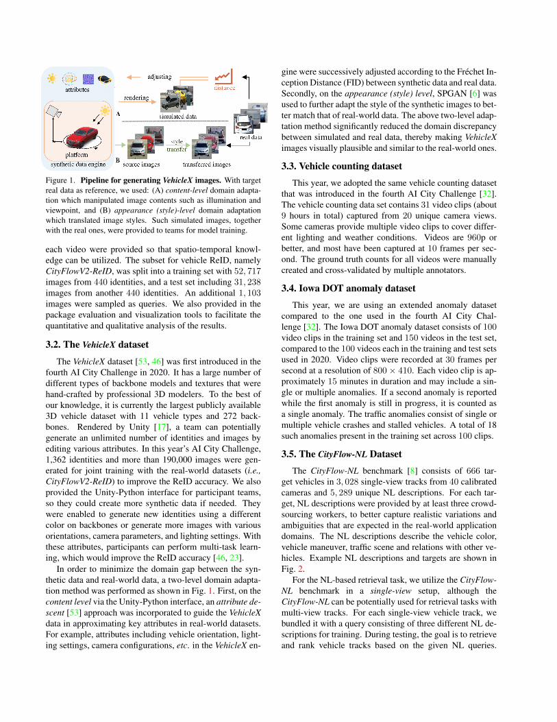
Figure 1. Pipeline for generating VehicleX images. With targetreal data as reference, we used: (A) content-level domain adapta-tion which manipulated image contents such as illumination andviewpoint, and (B) appearance (style)-level domain adaptationwhich translated image styles. Such simulated images, togetherwith the real ones, were provided to teams for model training.
each video were provided so that spatio-temporal knowl-edge can be utilized. The subset for vehicle ReID, namelyCityFlowV2-ReID, was split into a training set with 52, 717images from 440 identities, and a test set including 31, 238images from another 440 identities. An additional 1, 103images were sampled as queries. We also provided in thepackage evaluation and visualization tools to facilitate thequantitative and qualitative analysis of the results.
3.2. The VehicleX dataset
The VehicleX dataset [53, 46] was first introduced in thefourth AI City Challenge in 2020. It has a large number ofdifferent types of backbone models and textures that werehand-crafted by professional 3D modelers. To the best ofour knowledge, it is currently the largest publicly available3D vehicle dataset with 11 vehicle types and 272 back-bones. Rendered by Unity [17], a team can potentiallygenerate an unlimited number of identities and images byediting various attributes. In this year’s AI City Challenge,1,362 identities and more than 190,000 images were gen-erated for joint training with the real-world datasets (i.e.,CityFlowV2-ReID) to improve the ReID accuracy. We alsoprovided the Unity-Python interface for participant teams,so they could create more synthetic data if needed. Theywere enabled to generate new identities using a differentcolor on backbones or generate more images with variousorientations, camera parameters, and lighting settings. Withthese attributes, participants can perform multi-task learn-ing, which would improve the ReID accuracy [46, 23].
In order to minimize the domain gap between the syn-thetic data and real-world data, a two-level domain adapta-tion method was performed as shown in Fig. 1. First, on thecontent level via the Unity-Python interface, an attribute de-scent [53] approach was incorporated to guide the VehicleXdata in approximating key attributes in real-world datasets.For example, attributes including vehicle orientation, light-ing settings, camera configurations, etc. in the VehicleX en-
gine were successively adjusted according to the Frechet In-ception Distance (FID) between synthetic data and real data.Secondly, on the appearance (style) level, SPGAN [6] wasused to further adapt the style of the synthetic images to bet-ter match that of real-world data. The above two-level adap-tation method significantly reduced the domain discrepancybetween simulated and real data, thereby making VehicleXimages visually plausible and similar to the real-world ones.
3.3. Vehicle counting dataset
This year, we adopted the same vehicle counting datasetthat was introduced in the fourth AI City Challenge [32].The vehicle counting data set contains 31 video clips (about9 hours in total) captured from 20 unique camera views.Some cameras provide multiple video clips to cover differ-ent lighting and weather conditions. Videos are 960p orbetter, and most have been captured at 10 frames per sec-ond. The ground truth counts for all videos were manuallycreated and cross-validated by multiple annotators.
3.4. Iowa DOT anomaly dataset
This year, we are using an extended anomaly datasetcompared to the one used in the fourth AI City Chal-lenge [32]. The Iowa DOT anomaly dataset consists of 100video clips in the training set and 150 videos in the test set,compared to the 100 videos each in the training and test setsused in 2020. Video clips were recorded at 30 frames persecond at a resolution of 800 × 410. Each video clip is ap-proximately 15 minutes in duration and may include a sin-gle or multiple anomalies. If a second anomaly is reportedwhile the first anomaly is still in progress, it is counted asa single anomaly. The traffic anomalies consist of single ormultiple vehicle crashes and stalled vehicles. A total of 18such anomalies present in the training set across 100 clips.
3.5. The CityFlow-NL Dataset
The CityFlow-NL benchmark [8] consists of 666 tar-get vehicles in 3, 028 single-view tracks from 40 calibratedcameras and 5, 289 unique NL descriptions. For each tar-get, NL descriptions were provided by at least three crowd-sourcing workers, to better capture realistic variations andambiguities that are expected in the real-world applicationdomains. The NL descriptions describe the vehicle color,vehicle maneuver, traffic scene and relations with other ve-hicles. Example NL descriptions and targets are shown inFig. 2.
For the NL-based retrieval task, we utilize the CityFlow-NL benchmark in a single-view setup, although theCityFlow-NL can be potentially used for retrieval tasks withmulti-view tracks. For each single-view vehicle track, webundled it with a query consisting of three different NL de-scriptions for training. During testing, the goal is to retrieveand rank vehicle tracks based on the given NL queries.
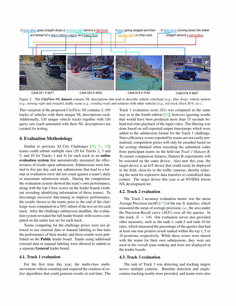
Figure 2. The CityFlow-NL dataset contains NL descriptions that tend to describe vehicle color/type (e.g., blue Jeep), vehicle motion(e.g., turning right and straight), traffic scene (e.g., winding road) and relations with other vehicles (e.g., red truck, black SUV, etc.).
This variation of the proposed CityFlow-NL contains 2, 498tracks of vehicles with three unique NL descriptions each.Additionally, 530 unique vehicle tracks together with 530query sets (each annotated with three NL descriptions) arecurated for testing.
4. Evaluation Methodology
Similar to previous AI City Challenges [30, 31, 32],teams could submit multiple runs (20 for Tracks 2, 3 and5, and 10 for Tracks 1 and 4) for each track to an onlineevaluation system that automatically measured the effec-tiveness of results upon submission. Submissions were lim-ited to five per day, and any submissions that lead to a for-mat or evaluation error did not count against a team’s dailyor maximum submission totals. During the competition,the evaluation system showed the team’s own performance,along with the top-3 best scores on the leader boards (with-out revealing identifying information of those teams). Todiscourage excessive fine-tuning to improve performance,the results shown to the teams prior to the end of the chal-lenge were computed on a 50% subset of the test set for eachtrack. After the challenge submission deadline, the evalua-tion system revealed the full leader boards with scores com-puted on the entire test set for each track.
Teams competing for the challenge prizes were not al-lowed to use external data or manual labeling to fine-tunethe performance of their model, and those results were pub-lished on the Public leader board. Teams using additionalexternal data or manual labeling were allowed to submit toa separate General leader board.
4.1. Track 1 evaluation
For the first time this year, the multi-class multi-movement vehicle counting task required the creation of on-line algorithms that could generate results in real time. The
Track 1 evaluation score (S1) was computed in the sameway as in the fourth edition [32], however ignoring resultsthat would have been produced more than 15 seconds be-hind real-time playback of the input video. The filtering wasdone based on self-reported output timestamps which wereadded to the submission format for the Track 1 challenge.Since efficiency scores reported by teams are not easily nor-malized, competition prizes will only be awarded based onthe scoring obtained when executing the submitted codesfrom participant teams on the held-out Track 1 Dataset B.To ensure comparison fairness, Dataset B experiments willbe executed on the same device. Also new this year, thetarget device is an IoT device that could easily be deployedin the field, close-by to the traffic cameras, thereby reduc-ing the need for expensive data transfers to centralized datacenters. The target device this year is an NVIDIA JetsonNX development kit.
4.2. Track 2 evaluation
The Track 2 accuracy evaluation metric was the meanAverage Precision (mAP) [57] of the top-K matches, whichmeasured the mean of average precision, i.e., the area underthe Precision-Recall curve (AUC) over all the queries. Inthis track, K = 100. Our evaluation server also providedother measures, such as the rank-1, rank-5 and rank-10 hitrates, which measured the percentage of the queries that hadat least one true positive result ranked within the top 1, 5 or10 positions, respectively. While these scores were sharedwith the teams for their own submissions, they were notused in the overall team ranking and were not displayed inthe leader boards.
4.3. Track 3 evaluation
The task of Track 3 was detecting and tracking targetsacross multiple cameras. Baseline detection and single-camera tracking results were provided, and teams were also
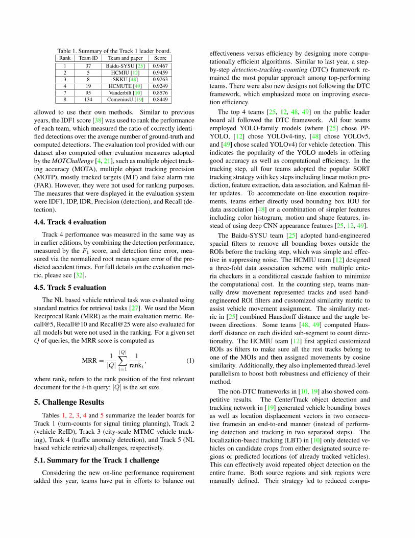
Table 1. Summary of the Track 1 leader board.Rank Team ID Team and paper Score
1 37 Baidu-SYSU [25] 0.94672 5 HCMIU [12] 0.94593 8 SKKU [48] 0.92634 19 HCMUTE [49] 0.92497 95 Vanderbilt [10] 0.85768 134 ComeniusU [19] 0.8449
allowed to use their own methods. Similar to previousyears, the IDF1 score [38] was used to rank the performanceof each team, which measured the ratio of correctly identi-fied detections over the average number of ground-truth andcomputed detections. The evaluation tool provided with ourdataset also computed other evaluation measures adoptedby the MOTChallenge [4, 21], such as multiple object track-ing accuracy (MOTA), multiple object tracking precision(MOTP), mostly tracked targets (MT) and false alarm rate(FAR). However, they were not used for ranking purposes.The measures that were displayed in the evaluation systemwere IDF1, IDP, IDR, Precision (detection), and Recall (de-tection).
4.4. Track 4 evaluation
Track 4 performance was measured in the same way asin earlier editions, by combining the detection performance,measured by the F1 score, and detection time error, mea-sured via the normalized root mean square error of the pre-dicted accident times. For full details on the evaluation met-ric, please see [32].
4.5. Track 5 evaluation
The NL based vehicle retrieval task was evaluated usingstandard metrics for retrieval tasks [27]. We used the MeanReciprocal Rank (MRR) as the main evaluation metric. Re-call@5, Recall@10 and Recall@25 were also evaluated forall models but were not used in the ranking. For a given setQ of queries, the MRR score is computed as
MRR =1
|Q|
|Q|∑i=1
1
ranki, (1)
where ranki refers to the rank position of the first relevantdocument for the i-th query; |Q| is the set size.
5. Challenge ResultsTables 1, 2, 3, 4 and 5 summarize the leader boards for
Track 1 (turn-counts for signal timing planning), Track 2(vehicle ReID), Track 3 (city-scale MTMC vehicle track-ing), Track 4 (traffic anomaly detection), and Track 5 (NLbased vehicle retrieval) challenges, respectively.
5.1. Summary for the Track 1 challenge
Considering the new on-line performance requirementadded this year, teams have put in efforts to balance out
effectiveness versus efficiency by designing more compu-tationally efficient algorithms. Similar to last year, a step-by-step detection-tracking-counting (DTC) framework re-mained the most popular approach among top-performingteams. There were also new designs not following the DTCframework, which emphasized more on improving execu-tion efficiency.
The top 4 teams [25, 12, 48, 49] on the public leaderboard all followed the DTC framework. All four teamsemployed YOLO-family models (where [25] chose PP-YOLO, [12] chose YOLOv4-tiny, [48] chose YOLOv5,and [49] chose scaled YOLOv4) for vehicle detection. Thisindicates the popularity of the YOLO models in offeringgood accuracy as well as computational efficiency. In thetracking step, all four teams adopted the popular SORTtracking strategy with key steps including linear motion pre-diction, feature extraction, data association, and Kalman fil-ter updates. To accommodate on-line execution require-ments, teams either directly used bounding box IOU fordata association [48] or a combination of simpler featuresincluding color histogram, motion and shape features, in-stead of using deep CNN appearance features [25, 12, 49].
The Baidu-SYSU team [25] adopted hand-engineeredspacial filters to remove all bounding boxes outside theROIs before the tracking step, which was simple and effec-tive in suppressing noise. The HCMIU team [12] designeda three-fold data association scheme with multiple crite-ria checkers in a conditional cascade fashion to minimizethe computational cost. In the counting step, teams man-ually drew movement represented tracks and used hand-engineered ROI filters and customized similarity metric toassist vehicle movement assignment. The similarity met-ric in [25] combined Hausdorff distance and the angle be-tween directions. Some teams [48, 49] computed Haus-dorff distance on each divided sub-segment to count direc-tionality. The HCMIU team [12] first applied customizedROIs as filters to make sure all the rest tracks belong toone of the MOIs and then assigned movements by cosinesimilarity. Additionally, they also implemented thread-levelparallelism to boost both robustness and efficiency of theirmethod.
The non-DTC frameworks in [10, 19] also showed com-petitive results. The CenterTrack object detection andtracking network in [19] generated vehicle bounding boxesas well as location displacement vectors in two consecu-tive framesin an end-to-end manner (instead of perform-ing detection and tracking in two separated steps). Thelocalization-based tracking (LBT) in [10] only detected ve-hicles on candidate crops from either designated source re-gions or predicted locations (of already tracked vehicles).This can effectively avoid repeated object detection on theentire frame. Both source regions and sink regions weremanually defined. Their strategy led to reduced compu-
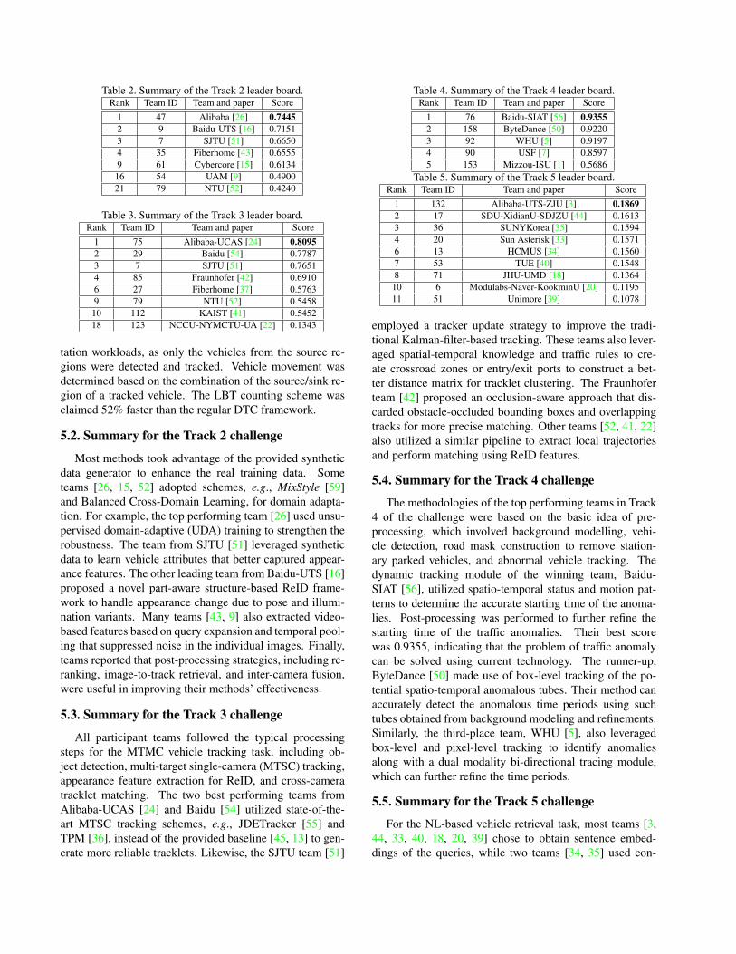
Table 2. Summary of the Track 2 leader board.Rank Team ID Team and paper Score
1 47 Alibaba [26] 0.74452 9 Baidu-UTS [16] 0.71513 7 SJTU [51] 0.66504 35 Fiberhome [43] 0.65559 61 Cybercore [15] 0.613416 54 UAM [9] 0.490021 79 NTU [52] 0.4240
Table 3. Summary of the Track 3 leader board.Rank Team ID Team and paper Score
1 75 Alibaba-UCAS [24] 0.80952 29 Baidu [54] 0.77873 7 SJTU [51] 0.76514 85 Fraunhofer [42] 0.69106 27 Fiberhome [37] 0.57639 79 NTU [52] 0.545810 112 KAIST [41] 0.545218 123 NCCU-NYMCTU-UA [22] 0.1343
tation workloads, as only the vehicles from the source re-gions were detected and tracked. Vehicle movement wasdetermined based on the combination of the source/sink re-gion of a tracked vehicle. The LBT counting scheme wasclaimed 52% faster than the regular DTC framework.
5.2. Summary for the Track 2 challenge
Most methods took advantage of the provided syntheticdata generator to enhance the real training data. Someteams [26, 15, 52] adopted schemes, e.g., MixStyle [59]and Balanced Cross-Domain Learning, for domain adapta-tion. For example, the top performing team [26] used unsu-pervised domain-adaptive (UDA) training to strengthen therobustness. The team from SJTU [51] leveraged syntheticdata to learn vehicle attributes that better captured appear-ance features. The other leading team from Baidu-UTS [16]proposed a novel part-aware structure-based ReID frame-work to handle appearance change due to pose and illumi-nation variants. Many teams [43, 9] also extracted video-based features based on query expansion and temporal pool-ing that suppressed noise in the individual images. Finally,teams reported that post-processing strategies, including re-ranking, image-to-track retrieval, and inter-camera fusion,were useful in improving their methods’ effectiveness.
5.3. Summary for the Track 3 challenge
All participant teams followed the typical processingsteps for the MTMC vehicle tracking task, including ob-ject detection, multi-target single-camera (MTSC) tracking,appearance feature extraction for ReID, and cross-cameratracklet matching. The two best performing teams fromAlibaba-UCAS [24] and Baidu [54] utilized state-of-the-art MTSC tracking schemes, e.g., JDETracker [55] andTPM [36], instead of the provided baseline [45, 13] to gen-erate more reliable tracklets. Likewise, the SJTU team [51]
Table 4. Summary of the Track 4 leader board.Rank Team ID Team and paper Score
1 76 Baidu-SIAT [56] 0.93552 158 ByteDance [50] 0.92203 92 WHU [5] 0.91974 90 USF [7] 0.85975 153 Mizzou-ISU [1] 0.5686
Table 5. Summary of the Track 5 leader board.Rank Team ID Team and paper Score
1 132 Alibaba-UTS-ZJU [3] 0.18692 17 SDU-XidianU-SDJZU [44] 0.16133 36 SUNYKorea [35] 0.15944 20 Sun Asterisk [33] 0.15716 13 HCMUS [34] 0.15607 53 TUE [40] 0.15488 71 JHU-UMD [18] 0.136410 6 Modulabs-Naver-KookminU [20] 0.119511 51 Unimore [39] 0.1078
employed a tracker update strategy to improve the tradi-tional Kalman-filter-based tracking. These teams also lever-aged spatial-temporal knowledge and traffic rules to cre-ate crossroad zones or entry/exit ports to construct a bet-ter distance matrix for tracklet clustering. The Fraunhoferteam [42] proposed an occlusion-aware approach that dis-carded obstacle-occluded bounding boxes and overlappingtracks for more precise matching. Other teams [52, 41, 22]also utilized a similar pipeline to extract local trajectoriesand perform matching using ReID features.
5.4. Summary for the Track 4 challenge
The methodologies of the top performing teams in Track4 of the challenge were based on the basic idea of pre-processing, which involved background modelling, vehi-cle detection, road mask construction to remove station-ary parked vehicles, and abnormal vehicle tracking. Thedynamic tracking module of the winning team, Baidu-SIAT [56], utilized spatio-temporal status and motion pat-terns to determine the accurate starting time of the anoma-lies. Post-processing was performed to further refine thestarting time of the traffic anomalies. Their best scorewas 0.9355, indicating that the problem of traffic anomalycan be solved using current technology. The runner-up,ByteDance [50] made use of box-level tracking of the po-tential spatio-temporal anomalous tubes. Their method canaccurately detect the anomalous time periods using suchtubes obtained from background modeling and refinements.Similarly, the third-place team, WHU [5], also leveragedbox-level and pixel-level tracking to identify anomaliesalong with a dual modality bi-directional tracing module,which can further refine the time periods.
5.5. Summary for the Track 5 challenge
For the NL-based vehicle retrieval task, most teams [3,44, 33, 40, 18, 20, 39] chose to obtain sentence embed-dings of the queries, while two teams [34, 35] used con-
ventional NLP techniques to process the NL queries. Forthe cross-modality learning, some teams [40, 3] utilized theReID models (approaches from the Track 2 challenge). Theadoption of vision models pre-trained on visual ReID datashowed improvements from their corresponding baselines.Vehicle motion is an essential part of the NL descriptionsin CityFlow-NL. Therefore, some teams [3, 20, 35] devel-oped specific approaches to measure and represent the ve-hicle motion patterns.
The best performing model [3] considered both local(visual) and global representations of the vehicle trajecto-ries to encode vehicle motion. In addition, NL augmen-tation via language translation was used to improve theperformance of the retrieval. The second best performingmodel [44] used GloVe and a custom built gated recurrentunit (GRU) to measure the similarity between visual cropsand the query. The method in [20] retrieved the target ve-hicle by performing per-frame segmentation, which can bederived as a visual tracker. However, the performance ofthis tracker was sub-optimal. [34] used semantic role la-beling techniques on the NL descriptions to rank and re-trieve the vehicle tracks. [35] not only considered the vehi-cle motion but also relations w.r.t. other vehicles describedin the NL queries. This approach yielded the best perform-ing model not relying on sentence embeddings for similaritymeasurements.
6. ConclusionThe fifth edition of the AI City Challenge continues to at-
tract worldwide research community participation in termsof both quantity and quality. A few observations are notedbelow.
The main thrust of Track 1 this year was the evaluation ofcounting methods on edge IoT devices. To this end, teamshave put significant efforts in optimizing algorithms aswell as implementation pipelines for performance improve-ment. The detection-tracking-counting (DTC) frameworkremained the most popular scheme among top-performingteams [25, 12, 48, 49]. Within the DTC framework, objecttracking was the focus of greater attention. Methods notusing deep-appearance-based features proved to be both ef-fective and cost-efficient in the feature extraction and dataassociation. We have also seen innovative designs [10, 19]not following the DTC framework and instead emphasizingon execution efficiency and showing competitive results.
In Tracks 2, 3 and 4, we have significantly expanded thedatasets, which motivated teams to train more robust mod-els that could be applied to diverse scenarios. In Track 2,we made major improvements to the Unity-Python interfaceof the synthetic data generator that enabled teams to ren-der vehicle identities of various colors, orientations, cam-era parameters, light settings, etc. The top-ranked teamson the leader board leveraged UDA schemes to stabilize
training across different domains that resulted in their re-markable performance. In Track 3, a new test set has beenadded since the fourth edition of the Challenge and the la-bels of bounding boxes have been largely refined to includemore small-sized objects. To tackle this challenging prob-lem, teams utilized state-of-the-art tracking methods to cre-ate reliable tracklets and introduced cross-camera matchingalgorithms based on spatio-temporal information as well astraffic rules and topological structures. As for Track 4, thetest set has grown by 150% compared to the fourth editionin the last year. We have seen teams adopting different typesof approaches to detect anomalies, including tracking-basedalgorithms, background modeling, motion pattern under-standing, etc.
In Track 5, we proposed a novel challenge for NL basedvehicle retrieval. Teams were challenged to apply knowl-edge across computer vision and NLP to the identificationof proper vehicle tracks. Various approaches were intro-duced by teams to create representative motion features andappearance embeddings. Compared to the other challengetracks, the performance of the leading teams was far fromsaturation due to multiple factors. It was difficult to re-late the semantic labels to vehicle attributes especially forsome that exhibited long tails in the distribution. Moreover,the motion patterns of vehicles required to be described us-ing tracking techniques in 3D space and thus were hard totrain directly through NL descriptors. Finally, many vehi-cles shared similar colors and types, which forced the algo-rithms to distinguish targets through fine-grained details, awell-known issue for deep learning frameworks.
Future work for the AI City Challenge will continuepushing the twin objectives of advancing the state of theart and bridging the real-world utility. To this end, while wewill continue to increase the dataset sizes, we hope to findforward-thinking DOTs that will provide a platform to de-ploy some of the most promising approaches emerging outof the AI City Challenge in their operational environments.This new approach will also likely require developing novelevaluation metrics to compare previous status quo baselineswith the state-of-the-art AI-based systems developed in thechallenge. We believe such a collaboration would make thechallenge a truly unique opportunity for ITS applications inthe real world and would be of great benefit to the DOTs.
7. AcknowledgmentThe datasets of the fifth AI City Challenge would not
have been possible without significant contributions fromthe Iowa DOT and an urban traffic agency in the UnitedStates. This challenge was also made possible by signifi-cant data curation help from the NVIDIA Corporation andacademic partners at the Iowa State University, Boston Uni-versity, Lafayette College, Indian Institute of Technology,Kanpur and Australian National University.
References[1] Armstrong Aboah, Maged Shoman, Vishal Mandal, Sayedo-
midreza Davami, Yaw Adu-Gyamfi, and Anuj Sharma. Avision-based system for traffic anomaly detection using deeplearning and decision trees. In CVPR Workshop, 2021.
[2] Lisa Anne Hendricks, Oliver Wang, Eli Shechtman, JosefSivic, Trevor Darrell, and Bryan Russell. Localizing mo-ments in video with natural language. In ICCV, pages 5803–5812, 2017.
[3] Shuai Bai, Zhedong Zheng, Xiaohan Wang, Junyang Lin,Zhu Zhang, Chang Zhou, Hongxia Yang, and Yi Yang. Con-necting language and vision for natural language-based ve-hicle retrieval. In CVPR Workshop, 2021.
[4] Keni Bernardin and Rainer Stiefelhagen. Evaluating mul-tiple object tracking performance: The clear mot metrics.EURASIP JMIVP, 2008(1):246309, May 2008.
[5] Jingyuan Chen, Guanchen Ding, Yuchen Yang, Wenwei Han,Kangmin Xu, Tianyi Gao, Zhe Zhang, Wanping Ouyang,Hao Cai, and Zhenzhong Chen. Dual modality vehicleanomaly detection via bidirectional-trajectory tracing. InCVPR Workshop, 2021.
[6] Weijian Deng, Liang Zheng, Qixiang Ye, Guoliang Kang, YiYang, and Jianbin Jiao. Image-image domain adaptation withpreserved self-similarity and domain-dissimilarity for personre-identification. In CVPR, pages 994–1003, 2018.
[7] Keval Doshi and Yasin Yilmaz. An efficient approach foranomaly detection in traffic videos. In CVPR Workshop,2021.
[8] Qi Feng, Vitaly Ablavsky, and Stan Sclaroff. CityFlow-NL:Tracking and retrieval of vehicles at city scaleby natural lan-guage descriptions. arXiv:2101.04741, 2021.
[9] Marta Fernandez, Paula Moral, Alvaro Garcia-Martin, andJose M. Martinez. Vehicle re-identification based on en-sembling deep learning features including a synthetic train-ing dataset, orientation and background features, and cameraverification. In CVPR Workshop, 2021.
[10] Derek Gloudemans and Daniel B. Work. Fast vehicleturning-movement counting using localization-based track-ing. In CVPR Workshop, 2021.
[11] Xiaoxiao Guo, Hui Wu, Yu Cheng, Steven Rennie, GeraldTesauro, and Rogerio Feris. Dialog-based interactive imageretrieval. In NeurIPS, pages 678–688, 2018.
[12] Synh Viet-Uyen Ha, Nhat Minh Chung, Tien-CuongNguyen, and Hung Ngoc Phan. Tiny-PIRATE: A tiny modelwith parallelized intelligence for real-time analysis as a traf-fic counter. In CVPR Workshop, 2021.
[13] Hung-Min Hsu, Tsung-Wei Huang, Gaoang Wang, JiaruiCai, Zhichao Lei, and Jenq-Neng Hwang. Multi-cameratracking of vehicles based on deep features Re-ID andtrajectory-based camera link modelsodels. In CVPR Work-shop, 2019.
[14] Ronghang Hu, Huazhe Xu, Marcus Rohrbach, Jiashi Feng,Kate Saenko, and Trevor Darrell. Natural language objectretrieval. In CVPR, pages 4555–4564, 2016.
[15] Su V. Huynh, Nam H. Nguyen, Ngoc T. Nguyen, Vinh TQ.Nguyen, Chau Huynh, and Chuong H.Nguyen. A strong
baseline for vehicle re-identification. In CVPR Workshop,2021.
[16] Minyue Jiang, Xuanmeng Zhang, Yue Yu, Zechen Bai, Zhe-dong Zheng, Zhigang Wang, Jian Wang, Xiao Tan, Hao Sun,Errui Ding, and Yi Yang. Robust vehicle re-identification viarigid structure prior. In CVPR Workshop, 2021.
[17] Arthur Juliani, Vincent-Pierre Berges, Ervin Teng, AndrewCohen, Jonathan Harper, Chris Elion, Chris Goy, Yuan Gao,Hunter Henry, Marwan Mattar, et al. Unity: A general plat-form for intelligent agents. arXiv:1809.02627, 2018.
[18] Pirazh Khorramshahi, Sai Saketh Rambhatla, and RamaChellappa. Towards accurate visual and natural language-based vehicle retrieval systems. In CVPR Workshop, 2021.
[19] Viktor Kocur and Milan Ftacnik. Multi-class multi-movement vehicle counting based on CenterTrack. In CVPRWorkshop, 2021.
[20] Sangrok Lee, Taekang Woo, and Sang Hun Lee. SBNet:Segmentation-based network for natural language-based ve-hicle retrieval. In CVPR Workshop, 2021.
[21] Yuan Li, Chang Huang, and Ram Nevatia. Learning to asso-ciate: Hybrid boosted multi-target tracker for crowded scene.In Proc. CVPR, pages 2953–2960, 2009.
[22] Yun-Lun Li, Zhi-Yi Chin, Ming-Ching Chang, and Chen-Kuo Chiang. Multi-camera tracklet matching using Group-IOU. In CVPR Workshop, 2021.
[23] Yutian Lin, Liang Zheng, Zhedong Zheng, Yu Wu, Zhi-lan Hu, Chenggang Yan, and Yi Yang. Improving personre-identification by attribute and identity learning. PatternRecognition, 95:151–161, 2019.
[24] Chong Liu, Yuqi Zhang, Hao Luo, Jiasheng Tang, WeihuaChen, Xianzhe Xu, Fan Wang, Hao Li, and Yi-Dong Shen.City-scale multi-camera vehicle tracking guided by cross-road zones. In CVPR Workshop, 2021.
[25] Jincheng Lu, Meng Xia, Xu Gao, Xipeng Yang, TianranTao, Hao Meng, Wei Zhang, Xiao Tan, Yifeng Shi, Guan-bin Li, and Errui Ding. Robust and online vehicle countingat crowded intersections. In CVPR Workshop, 2021.
[26] Hao Luo, Weihua Chen, Xianzhe Xu, Jianyang Gu, YuqiZhang, Chong Liu, Shuting He, Fan Wang, and Hao Li. Anempirical study of vehicle re-identification on the AI CityChallenge. In CVPR Workshop, 2021.
[27] Christopher D Manning, Hinrich Schutze, and PrabhakarRaghavan. Introduction to information retrieval. CambridgeUniversity Press, 2008.
[28] Junhua Mao, Jonathan Huang, Alexander Toshev, OanaCamburu, Alan L Yuille, and Kevin Murphy. Generationand comprehension of unambiguous object descriptions. InCVPR, pages 11–20, 2016.
[29] Milind Naphade, David C. Anastasiu, Anuj Sharma, VamsiJagrlamudi, Hyeran Jeon, Kaikai Liu, Ming-Ching Chang,Siwei Lyu, and Zeyu Gao. The NVIDIA AI City Challenge.In Prof. SmartWorld, Santa Clara, CA, USA, 2017.
[30] Milind Naphade, Ming-Ching Chang, Anuj Sharma,David C. Anastasiu, Vamsi Jagarlamudi, PranameshChakraborty, Tingting Huang, Shuo Wang, Ming-Yu Liu,Rama Chellappa, Jenq-Neng Hwang, and Siwei Lyu. The2018 NVIDIA AI City Challenge. In CVPR Workshop, pages53––60, 2018.
[31] Milind Naphade, Zheng Tang, Ming-Ching Chang, David C.Anastasiu, Anuj Sharma, Rama Chellappa, Shuo Wang,Pranamesh Chakraborty, Tingting Huang, Jenq-NengHwang, and Siwei Lyu. The 2019 AI City Challenge. InCVPR Workshop, page 452–460, 2019.
[32] Milind Naphade, Shuo Wang, David C. Anastasiu, ZhengTang, Ming-Ching Chang, Xiaodong Yang, Liang Zheng,Anuj Sharma, Rama Chellappa, and Pranamesh Chakraborty.The 4th AI City Challenge. In CVPR Workshop, 2020.
[33] Tam Minh Nguyen, Quang Huu Pham, Linh Bao Doan,Hoang Viet Trinh, and Viet-Anh Nguyen. Contrastive learn-ing for natural language-based vehicle retrieval. In CVPRWorkshop, 2021.
[34] Tien-Phat Nguyen, Ba-Thinh Tran-Le, Xuan-Dang Thai,Tam V. Nguyen, Minh N. Do, and Minh-Triet Tran. Trafficvideo event retrieval via text query using vehicle appearanceand motion attributes. In CVPR Workshop, 2021.
[35] Eun-Ju Park, Hoyoung Kim, Seonghwan Jeong, ByungkonKang, and YoungMin Kwon. Keyword-based vehicle re-trieval. In CVPR Workshop, 2021.
[36] Jinlong Peng, Tao Wang, Weiyao Lin, Jian Wang, JohnSee, Shilei Wen, and Erui Ding. TPM: Multiple objecttracking with tracklet-plane matching. Pattern Recognition,107(107480), 2020.
[37] Pengfei Ren, Kang Lu, Yu Yang, Yun Yang, Guangze Sun,Wei Wang, Gang Wang, Junliang Cao, Zhifeng Zhao, andWei Liu. Multi-camera vehicle tracking system based onspatial-temporal filtering. In CVPR Workshop, 2021.
[38] Ergys Ristani, Francesco Solera, Roger Zou, Rita Cucchiara,and Carlo Tomasi. Performance measures and a data set formulti-target, multi-camera tracking. In Proc. ECCV, pages17–35, 2016.
[39] Carmelo Scribano, Davide Sapienza, Giorgia Franchini, Mi-caela Verucchi, and Marko Bertogna. All You Can Embed:Spatio-temporal transformers for natural language based ve-hicle retrieval. In CVPR Workshop, 2021.
[40] Clint Sebastian, Raffaele Imbriaco, Panagiotis Meletis, GijsDubbelman, Egor Bondarev, and Peter H.N. de With. TIED:A cycle consistent encoder-decoder model for text-to-imageretrieval. In CVPR Workshop, 2021.
[41] Kyujin Shim, Sungjoon Yoon, Kangwook Ko, and ChangickKim. Multi-target multi-camera vehicle tracking for city-scale traffic management. In CVPR Workshop, 2021.
[42] Andreas Specker, Daniel Stadler, Lucas Florin, and Jur-gen Beyerer. An occlusion-aware multi-target multi-cameratracking system. In CVPR Workshop, 2021.
[43] Yongli Sun, Wenpeng Li, Hua Wei, Longtao Zhang, Jia-hao Tian, Guangze Sun, Gang Wang, Junliang Cao, ZhifengZhao, and Junfeng Ding. Progressive data mining andadaptive weighted multi-model ensemble for vehicle re-identification. In CVPR Workshop, 2021.
[44] Ziruo Sun, Xinfang Liu, Xiaopeng Bi, Xiushan Nie, and Yi-long Yin. DUN: Dual-path temporal matching network fornatural language-based vehicle retrieval. In CVPR Work-shop, 2021.
[45] Zheng Tang and Jenq-Neng Hwang. MOANA: An onlinelearned adaptive appearance model for robust multiple objecttracking in 3D. IEEE Access, 7(1):31934–31945, 2019.
[46] Zheng Tang, Milind Naphade, Stan Birchfield, JonathanTremblay, William Hodge, Ratnesh Kumar, Shuo Wang, andXiaodong Yang. PAMTRI: Pose-aware multi-task learningfor vehicle re-identification using highly randomized syn-thetic data. In Proc. ICCV, page 211–220, 2019.
[47] Zheng Tang, Milind Naphade, Ming-Yu Liu, XiaodongYang, Stan Birchfield, Shuo Wang, Ratnesh Kumar, David C.Anastasiu, and Jenq-Neng Hwang. CityFlow: A city-scalebenchmark for multi-target multi-camera vehicle trackingand re-identification. In Proc. CVPR, 2019.
[48] Duong Nguyen-Ngoc Tran, Long Hoang Pham, Huy-HungNguyen, Tai Huu-Phuong Tran, Hyung-Joon Jeon, andJae Wook Jeon. A regional weighted trajectory techniquefor multiple turn-counts at road intersection on edge device.In CVPR Workshop, 2021.
[49] Vu-Hoang Tran, Le-Hoai-Hieu Dang, Chinh-NghiepNguyen, Ngoc-Hoang-Lam Le, Khanh-Phong Bui, Lam-Truong Dam, Quang-Thang Le, and Dinh-Hiep Huynh.Real-time and robust system for counting movement-specificvehicle at crowded intersections. In CVPR Workshop, 2021.
[50] Jie Wu, Xionghui Wang, Xuefeng Xiao, and Yitong Wang.Box-level tube tracking and refinement for vehicles anomalydetection. In CVPR Workshop, 2021.
[51] Minghu Wu, Yeqiang Qian, Chunxiang Wang, and MingYang. A multi-camera vehicle tracking system based on city-scale vehicle Re-ID and spatial-temporal information. InCVPR Workshop, 2021.
[52] Kai-Siang Yang, Yu-Kai Chen, Tsai-Shien Chen, Chih-TingLiu, and Shao-Yi Chien. Tracklet-refined multi-cameratracking for vehicles based on balanced cross-domain re-identification. In CVPR Workshop, 2021.
[53] Yue Yao, Liang Zheng, Xiaodong Yang, Milind Naphade,and Tom Gedeon. Simulating content consistent vehicledatasets with attribute descent. arXiv:1912.08855, 2019.
[54] Jin Ye, Xipeng Yang, Shuai Kang, Yue He, Weiming Zhang,Leping Huang, Wei Zhang, Yifeng Shi, and Xiao Tan. Arobust MTMC tracking system for AI-City Challenge 2021.In CVPR Workshop, 2021.
[55] Yifu Zhang, Chunyu Wang, Xinggang Wang, WenjunZeng, and Wenyu Liu. FairMOT: On the fairness ofdetection and re-identification in multiple object tracking.arXiv:2004.01888, 2020.
[56] Yuxiang Zhao, Wenhao Wu, Yue He, Yingying Li, Xiao Tan,and Shifeng Chen. Good practices and a strong baseline fortraffic anomaly detection. In CVPR Workshop, 2021.
[57] Liang Zheng, Liyue Shen, Lu Tian, Shengjin Wang, Jing-dong Wang, and Qi Tian. Scalable person re-identification:A benchmark. In Proc. ICCV, pages 1116–1124, 2015.
[58] Zhedong Zheng, Xiaodong Yang, Zhiding Yu, Liang Zheng,Yi Yang, and Jan Kautz. Joint discriminative and generativelearning for person re-identification. In CVPR, pages 678–688, 2019.
[59] Kaiyang Zhou, Yongxin Yang, Yu Qiao, and Tao Xiang. Do-main generalization with MixStyle. In Proc. ICLR, 2021.
[60] Yang Zou, Xiaodong Yang, Zhiding Yu, B.V.K. VijayaKuma, and Jan Kautz. Joint disentangling and adaptationfor cross-domain person re-identification. In ECCV, pages678–688, 2020.