Embed Size (px)
Citation preview
Review of Historical Geography and Toponomastics, vol. II, no.3-4, 2007, pp 167-178
THE AGE AND EVOLUTION OF THE SETTLEMENTS NETWORK IN ALMĂJ LAND (15TH – 20TH CENTURIES)
Ana-Neli IANĂŞ, Daniela DRĂGAN
PhD Teach. Assist., West University of Timişoara, Department of Geography, Blv. V. Pârvan, No.4, 300223, Timişoara, Romania, e-mail: [email protected] PhD student, “Babeş-Bolyai”University, Faculty of Geography, Clinicilor, No.5-
7, Cluj-Napoca, Romania, e-mail: [email protected]
Abstract. The age and evolution of the settlements network in Almăj Land (15th–20th centuries). Since Almăj Land (depression) is considered part of the territorial entities category “terra” in the Carpathian Mountains, the analysis of the age and evolution of the human settlements that define the habitat of this type of territorial system is very important, especially in order to identify its functionality and evolution. Human life in this territory has been attested by the documents and archaeological discoveries as dating from the Bronze Age and having the greatest development in the Roman period. Configuration of the Almăj settlement network started only from the 15th century, influenced the relief, the availability of drinking water and fertile soil, also transport infrastructure which has the role to ensure the connections between the system’s settlements or the connections of matter, energy and information between these and the neighboring regions. If, in the past, the human settlements from Almăj Land were represented by some hamlets in the mountain area (with the relief as a shield against foreign attacks), starting with the 18th century, and Austro-Hungarian Empire’s domination in Banat, the hamlets from the mountain area disappeared, with the population drawn to adjacent settlements. The Habsburg domination influenced also Czech colonization with some settlements at a high altitude in the mountains (for example Ravensca village) for economic needs and flood risk in the Nera Valley, contributed to a „swarming” process and the creation of new settlements as Şopotu Nou and Borlovenii Noi. The completion of the current structure for this regional system (which comprises 31 human settlements, all villages) was realized at the 1956 census when the last existing hamlets were declared villages.
Ana-Neli IANĂŞ, Daniela DRĂGAN
168
Rezumat. Vechimea şi evoluţia reţelei de aşezări din Ţara Almăjului (secolele XV-XX). Întrucât Ţara Almăjului face parte din categoria entităţilor teritoriale de tip “terra” din Munţii Carpaţi, analiza vechimii şi evoluţiei aşezărilor omeneşti ce definesc componenta de habitat a acestui tip de sisteme teritoriale este foarte importantă, mai ales în vederea identificării funcţionalităţii şi a evoluţiei acestuia. Locuirea acestui teritoriu a fost atestată documentar şi în urma descoperirilor arheologice ca datând din epoca bronzului şi având cea mai mare dezvoltare în perioada romană. Configuraţia actuală a reţelei de aşezări din sistemul regional Ţara Almăjului a început să se contureze abia din secolul al XV –lea, un rol deosebit în acestă privinţă având-o: relieful, apropierea de resursele de apă şi de solurile cu grad ridicat de fertilitate, proximitatea faţă de infrastructura de transport care să asigure legăturile dintre aşezările sistemului, sau schimburile de materie, energie şi informaţie între acesta şi regiunile învecinate. Dacă în trecut, aşezările din Ţara Almăjului erau reprezentate de cătunele din zona montană (relieful având rolul de adăpost şi apărare împotriva năvălirilor străine), începând cu secolul al XVIII – lea şi intrarea Banatului sub stăpânirea Imperiului Austro-Ungar, cătunele din zona montană au dispărut, populaţia fiind înglobată în localităţile aflate la cea mai mare apropiere. Aceeaşi dominaţie habsburgică a determinat şi procesul de colonizare a cehilor, respectiv apariţia unor aşezări pe cele mai înalte culmi ale munţilor (de exemplu Ravensca), iar necesitatea realizării diferitelor activităţi economice sau gradul ridicat al riscurilor hidrologice (inundatiile pe râul Nera), au influenţat procesul roirii populaţiei şi crearea altor aşezări, după cum o demonstrează şi numele acestora (Borlovenii Noi, Şopotu Nou). Definitivarea structurii actuale a componentei de habitat a sistemului regional analizat (care cuprinde 31 de aşezări omeneşti, toate sate) s-a realizat la recensământul din 1956 când ultimele cătune existente au fost declarate sate. Key-words: settlements network, hamlet, regional system, Almăj Land Cuvinte cheie: reţea de aşezări, cătun, sistem regional, Ţara Almăjului
1. INTRODUCTION
Almăj Land is considered part of the territorial entities category “terra” in the Carpathian Mountains and they have been mentioned from the beginning of the millennium BC II d, when these were very well organized.
Almăj Land provided good conditions for humanization process since ancient times, because of its rich and varied resources and because of the role of shield that the surrounding mountains had, promoting the realization of a settlements network, documentary attested from the 15th century. The proof of this claim, were the numerous archaeological discoveries, material remains, some written documents and especially, the traditional forms of the rural life which are maintained until today. Taking into consideration these aspects, we’ll try to highlight some of the proofs which are revealing the early humanization of the analysed space, focussing on the discovery of settlements traces, without mentioning other archaeological discoveries (implements, ceramics, coins etc.) that will be made in other detailed study.
The age and evolution of the settlements network in Almăj Land (15th – 20th centuries)
169
2. PROOFS OF THE HUMANIZATION PROCESS BEFORE 15th CENTURY
Among the oldest evidences of the humanization process of this space are the
archaeological discoveries from the Bronze Age (2500 – 1700 BC) on the current communes territory Bănia and Eftimie Murgu, which also brought to light the traces of a Coţofeni settlement on Socolăţ Hill, at the place called Piatra Oborului (Moga, Gudea, 1975). Other traces of a Dacian fortified settlement from Middle Bronze Age, Hallstatt, were found on the Leu or Balta Neagră Plateau from Borlovenii Vechi settlement (Sitariu, 2005). Living this space was due to the existence and discovery of some local resources, particularly gold and copper resources used for manufacturing jewelry. Their existence is sustained by some noting that the river’s beds Caraş, Lăpuş, Timiş and Nera contained gold sands and their exploitation does not involve complicated technical processes (Mărghitan, 1979).
The Iron Age, which began in the 12th century BC, was characterized by an intensification of the humanization process, traces of some settlements walls from the first period of this era being discovered at Bănia, on the Pârâului Valley and Big Valley, at the places Arie and Comorâşniţa. Other discoveries from this period were: the traces of a Dacian fortresse in Pătaş village and the ruins of Grădişte fortress (declared archaeological reserve) discovered in the southern of Dalboşeţ village (in the vernacular language Grădişte meaning Fortress). In this era, the features of the Daco-Getic civilization began to outline. Regarding the humanization process of this area by Dacians, in the western part of the Almăj Land, the fortress Mudava is notable, found on a map in the library of Vatican by professor Marius Bizerea. “The name of this fortress is kept unimpaired in the vernacular language: Mudaua, name registered on the Buceava Valley which flows in Nera river, before gorges” (Dolângă, 2000, p. 72). Even today, when the people from Almăj are passing through the forest from Şopotu Nou to Boşneag, they say that they are going to Mudava. The name dava prove the habitation of this area by Dacians.
Then, at the beginning of II century AD, Almăj Land was included in the boundaries of the Roman Empire which will be part of, until the end of 3rd century. The traces of a roman fortress have been discovered also near the Catholic cemetery from Bozovici, and some tombstones at Ogei, near Dragomireana, in Gârbovăţ village. Villa rustica from Dragomireana (Şopotu Vechi) was the center of a large agricultural Roman farm, its discovery being relevant to prove the economic polyvalence of the rural settlements from that period (Gaga, 1984), the place being considered also a Roman camp (Borza, 1943). The discoveries from the Roman period were the most numerous in Almăj Land : the traces of a settlement dating from 3rd – 4th centuries AD at Morii Vechi place from Borlovenii Vechi village and the traces of a Roman camp at the place Comoară (Prilipeţ village), on a brick being discovered a set of initials of the Cohort III Dalmatarom (Sitariu, 2003, p. 36).
In the early feudal period (7th – 10th centuries), the archaeological discoveries attested Romanians from Banat as farmers, livestock breeders, blacksmiths and potters.
Then, in 10th – 11th centuries, the population from Banat was part of Glad Principality, later was part of Ahtum Principality and it opposed with vehemence to the Hungarian expansion. During this period, Almăj Land had 15 – 20 villages. „The coins
Ana-Neli IANĂŞ, Daniela DRĂGAN
170
discovered at the two extremities of Almăj: Şopotu Nou and Pătaş prove that the settlements have been under Glad and Achtum Voivodship administration in the 10th and 11th centuries, Voivodes which had contacts with the South-Danubian Czardom” (Smeu, 1977, p. 19-20).
12th – 15th centuries were characterized by the establishment of some new settlements of Romanians in Banat and many rural settlements in Almăj depression. Almăj was a privileged district among the eight districts from Banat, because it was formed of Romanian population, the foreigners reaching with difficulty in the hill and mountain region from south-western Banat. “The first documentary attestations of the villages from Almăj Land have been made in 1241, when Gârlişte (Rudăria) and Bozovici settlements have been mentioned for the first time(...)” (Gaga, 1984, p. 13). The Cnezs from Almăj had an important role in the 15th century in the campaigns against Turks, contributing to strengthening the relations between Romanians from Almăj and others privileged districts from Banat.
3. THE EVOLUTION OF THE SETTLEMENTS NETWORK AFTER
15th CENTURY
In the 15th Century a document of Hungary King Sigismund was showing that in Almăj there were stabile settlements or principalities with 504 peasants, 32 border guards and 26 couriers (Motogna 1944).
Then, from the 16th century until the 18th century Banat was owned by Otoman Empire, in 1541 forming the Pashalik from Buda and the Almăj Land has become a border area of Transylvania Principality and passing through a great agitated period determinated by the Turks proximity. The Turk Administration Period (1658 - 1690) has been one of the most difficult for all villages from Almăj Land. The fact that Habsburgs intending to own the Banat Region included here also Almăj Land determinate the Turks to make many incursions and to destroy the villages from Almăj (Andrei, 2007).
Beginning with the 18th century the Banat Region passed under the Habsburgs Empire suzerainty and Almăj Land has been integrated on the border area of the empire. The population were obliged to pay considerable giving and taxes to the empire, fact realized during the first census in 1718. The consequence of this action were the living process of the villages by the peasants, these ones becoming brigands (lotri), fact that, finally, leads to the snock from 1737 - 1739 (Dolângă, 2000). This will be the end by the defeating of the insurgents from Almăj while many of them were sheltered themselves on Romanian and Serbian lands. After the Peace of Belgrad in 1739 it was made a new census realizing the fact that some parishes have disappeared, their inhabitants being removed to the closest locality. The inhabitants come down from pastoral settlements to the foot of the mountains. Thus, ,,the grazing as a permanently economic activity form stop and appear the familial grazing” (Smeu, 1977, pag. 35).
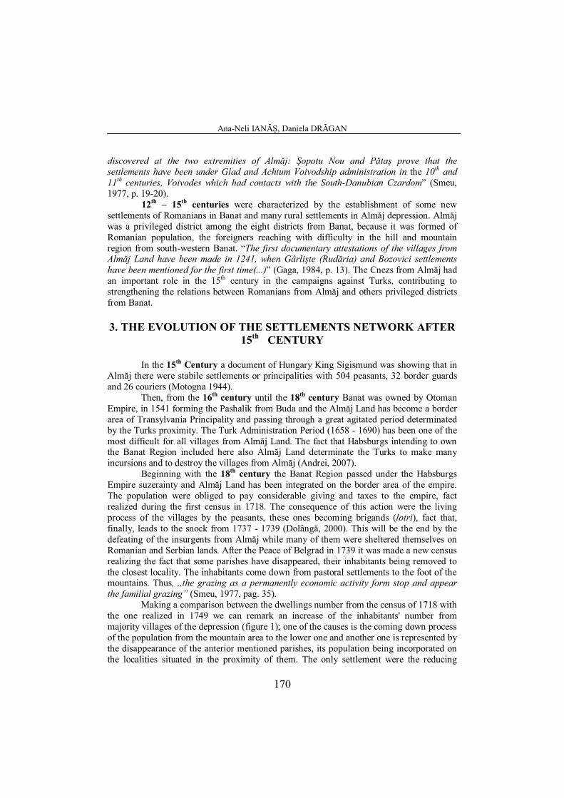
Making a comparison between the dwellings number from the census of 1718 with the one realized in 1749 we can remark an increase of the inhabitants' number from majority villages of the depression (figure 1); one of the causes is the coming down process of the population from the mountain area to the lower one and another one is represented by the disappearance of the anterior mentioned parishes, its population being incorporated on the localities situated in the proximity of them. The only settlement were the reducing
The age and evolution of the settlements network in Almăj Land (15th – 20th centuries)
171
process of the inhabitants is obvious is Putna. The population number is in decrease in 1749 compared to 1718 as an outcome of the moving process of the population to a distance about few kilometers, where in 1749 is formed a new settlement Borloveni.
0
20
40
60
80
100
120
Dwellings num ber
Bozo
vici
Băni
a
Borlo
veni
Dal
boşe
ţ
Gâr
bovă
ţ
Lăpu
şnic
Moc
eriş
Păta
ş
Prip
ileţ
Prig
or
Putn
a
Rud
ăria
Şopo
t
Tăria
-Lid
ovin
i Localities
17181749
Figure 1: The evolution of the dwellings number in Almăj Land in 1718 and 1749.
At the same historical period the King Joseph The 2nd made a trip in Banat and he was surprised by the poor status of all 13 villages from Almăj exhausted by the fights with the Turks and also, by the revolts against the Habsburgs, the inhabitants of Almăj Land strongly opposing to the militarization process of the region in which they're living (Negru, 1943). With all those, they started the setting up of the border regiments divided in companies. The “Româno-Iliric” Regiment has been divided in 16 companies, two of those being in Almăj Land, one in Bozovici (covering five villages) and another one in Prigor, to this last one belonging six villages (Gaga, 1984). The military authorities from Almaj have opposed to the foreign colonization in this region due to the fact that the population from here should be numerously enough and for the new population it would be difficult in their adaptation to the new climatic conditions (Popiţi, 1939). This fact ensured the majority of the Romanian population at that time. In 1779 when Banat has been divided in three counties (Timiş, Torontal and Caraş), the Almăj Land has continued to be a distinct area administrated by the War Council from Wien.
Finally in the 19th century it appeared the first diversification in the ethnic background from demographical point of view through the colonization process. Especially, it is represented by the coming of the Czech colonists who are forming in Almăj the village called Ravensca in 1858 ,,with 32 households summing 181 inhabitants” (Gaga, 1984, p. 15). Until this year the population from Almăj Land was homogenous, totally Romanian. The struggled history of the region with many wars and fights which had affected
Ana-Neli IANĂŞ, Daniela DRĂGAN
172
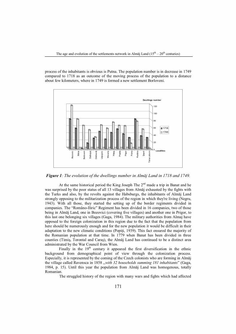
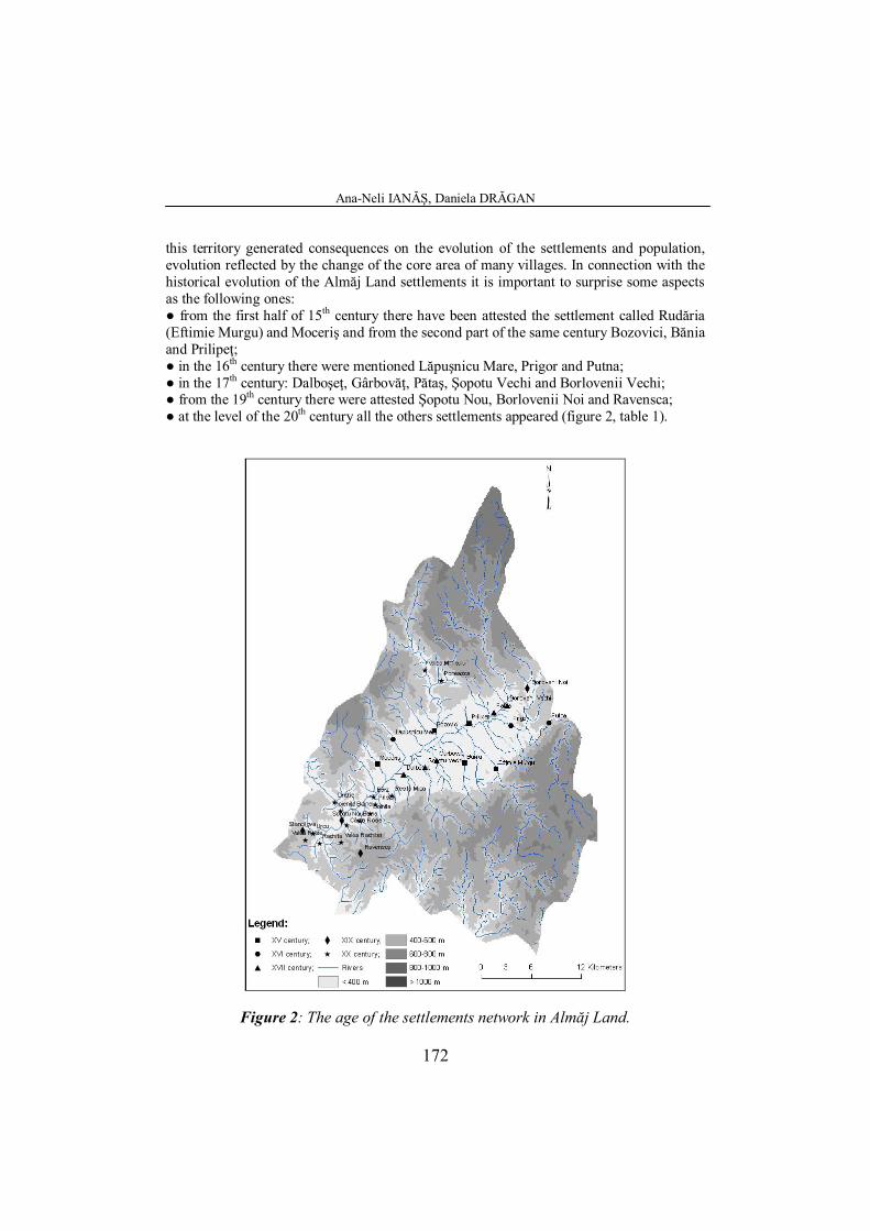
this territory generated consequences on the evolution of the settlements and population, evolution reflected by the change of the core area of many villages. In connection with the historical evolution of the Almăj Land settlements it is important to surprise some aspects as the following ones: ● from the first half of 15th century there have been attested the settlement called Rudăria (Eftimie Murgu) and Moceriş and from the second part of the same century Bozovici, Bănia and Prilipeţ; ● in the 16th century there were mentioned Lăpuşnicu Mare, Prigor and Putna; ● in the 17th century: Dalboşeţ, Gârbovăţ, Pătaş, Şopotu Vechi and Borlovenii Vechi; ● from the 19th century there were attested Şopotu Nou, Borlovenii Noi and Ravensca; ● at the level of the 20th century all the others settlements appeared (figure 2, table 1).
Figure 2: The age of the settlements network in Almăj Land.
The age and evolution of the settlements network in Almăj Land (15th – 20th centuries)
173
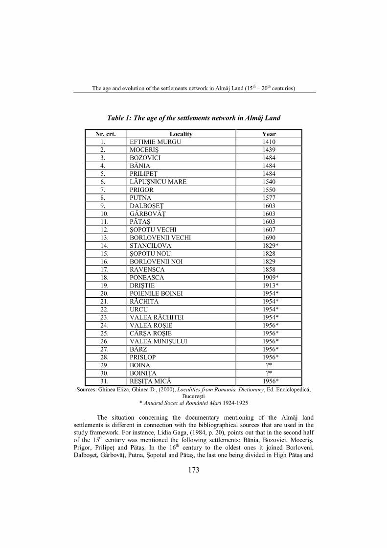
Table 1: The age of the settlements network in Almăj Land
Nr. crt. Locality Year 1. EFTIMIE MURGU 1410 2. MOCERIŞ 1439 3. BOZOVICI 1484 4. BĂNIA 1484 5. PRILIPEŢ 1484 6. LĂPUŞNICU MARE 1540 7. PRIGOR 1550 8. PUTNA 1577 9. DALBOŞEŢ 1603 10. GÂRBOVĂŢ 1603 11. PĂTAŞ 1603 12. ŞOPOTU VECHI 1607 13. BORLOVENII VECHI 1690 14. STANCILOVA 1829* 15. ŞOPOTU NOU 1828 16. BORLOVENII NOI 1829 17. RAVENSCA 1858 18. PONEASCA 1909* 19. DRIŞTIE 1913* 20. POIENILE BOINEI 1954* 21. RĂCHITA 1954* 22. URCU 1954* 23. VALEA RĂCHITEI 1954* 24. VALEA ROŞIE 1956* 25. CÂRŞA ROŞIE 1956* 26. VALEA MINIŞULUI 1956* 27. BÂRZ 1956* 28. PRISLOP 1956* 29. BOINA ?* 30. BOINIŢA ?* 31. REŞIŢA MICĂ 1956*
Sources: Ghinea Eliza, Ghinea D., (2000), Localities from Romania. Dictionary, Ed. Enciclopedică, Bucureşti
* Anuarul Socec al României Mari 1924-1925
The situation concerning the documentary mentioning of the Almăj land settlements is different in connection with the bibliographical sources that are used in the study framework. For instance, Lidia Gaga, (1984, p. 20), points out that in the second half of the 15th century was mentioned the following settlements: Bănia, Bozovici, Moceriş, Prigor, Prilipeţ and Pătaş. In the 16th century to the oldest ones it joined Borloveni, Dalboşeţ, Gârbovăţ, Putna, Şopotul and Pătaş, the last one being divided in High Pătaş and
Ana-Neli IANĂŞ, Daniela DRĂGAN
174
Down Pătaş. In the 18th century with the writing occasion of Joseph the 2nd travel journal from 1773 and also on the Grissellini's map of 1776 it have been mentioned 13 settlements as: Bozovici, Bănia, Borlovenii Vechi, Dalboşeţ, Gârbovăţ, Lăpuşnic, Moceriş, Pătaşul de Sus, Pătaşul de Jos, Prigor, Putna, Şopotul Vechi and Stancilova.
However, analyzing many sources (Smeu, 1977, Iosipescu, 1977, Nemiş, 1981, Sitariu, 2003) we tried to study the ex-village hearths, some of them disappearing and other were comprised or concentrated in the contemporary localities. From Dacians and Romans period there are reminded the existence of some villages which could be formed by the property process of the dismissed on the hearth veterans. These ones completed the old Dacian settlements as Grădiştea-Dalboşeţ (Sitariu, 2003). These localities represented an incipient phase that will form the village of today “a fascinating social and confessional structure” (Nemoianu, 2000, p. 1). In the following assertions we shall try, shortly, to present some considerations about the history of each locality.
Bozovici is formed by nine hearths (Cusec, Tăria, Jidovini, Pădijel, Craişte, Zăgrade, Roneşte, Lighidia and Miniş (today Minişului Valley). It is documentary attested for the first time in 1484 when Matei Corvin King powered Lazăr from Bozovici (Lazarus of Bohowith), called by Iorga “Almăjeanul” and who take part to the ennoblement ceremony of Iacob Gârlişteanu from Rudăria (Smeu, 1977). From the oldest times this locality was the most important economic, cultural and social centre from Almăj fact for other researchers give this appellative to the whole depression. Under the dominance of Austrian and Hungarian Empire it accomplished the administrative function of trammel residency being an important borough for the cattle export (Gaga, 1984). Bozovici has been described as a “compact amassed village” with a borough structure (Vuia, 1975, p. 193).
At the same year (1484) it is mentioned Prilipeţ village which today belongs to Bozovici Parish. During the military border period it was named Prilipetz and on the period of the Hungarian Administration it was called Perebeo (cf. P. U. G. Bozovici, 2000, p. 6). The village had three cores: on the Fir Tree Hill, on the Tăria Hill, and “La Comoară”, in present being located on the right bank of near river, approximately to 260m highest (Albert, 2003) along the way that follow the valley, the relief features being favorable for its spatial extend.
The village with a parish residency role, Rudăria, (after 1970 Eftimie Murgu), is formed by the core connection of Rustnic, Ielocu and Margianova. The parish comprises the cores of two villages Gârlişte (on the left bank of Rudăria beck) and Rudăria (on the right bank of it called today “Pre Ţărmuri”), (Gaga, 1984), being known among the time as Gârleşti, after Iacob de Gârlişte family, “ban” of Severin Region on whose lordship were been situated the settlement (Iosipescu, 1977, p. 12). It is a concentrate and elongated village along the Rudaria Valley on two parallel streets.
Bănia locality is formed by three former cores: Ogaşul Corbului, Cioaca lui Bodrilă and Valea Mică, being present in documents as Margina, Bandia and Pania. The village territory comprises a meadow area with a width about 3 km, a hill area about 4-6 km and a mountain area with a width of 22 km on the Big Valley. In length the territory extends on 40 km (Andrei, 2007, p. 12) and the highness is between 280 and 325 m. Bănia is documentary attested in 1484 when Matei Corvin King gives the Iacob Gârlişteanu, lord of Rudăria, many manors with villages from these ones Marginea and Sălişte belonging to Bănia, Marginea being the biggest one. However, “Vasile de Bănia”, “cneaz” at that times, mentioned the fact that the village already exists in the actual hearth/core and it was named with this appellative anterior by 1484 (Andrei, 2007, p. 60).
The age and evolution of the settlements network in Almăj Land (15th – 20th centuries)
175
The Communist Party tried the abolition of some communes, such as Bănia and Eftimie Murgu, while Bozovici become a mammoth commune constituted from the villages: Bozovici, Prilipeţ, Eftimie Murgu, Bănia, Gârbovăţ, Lăpuşnicu Mare and Moceriş.
Gârbovăţ village was attested for the first time with this name in 1603, when it had 28 wood houses (Sitariu, 2005). The village had a hearth lower than the current one, in the place Sălişte. Even the village was called Sălişte until in 1756, when because of the flood, the village moved its hearth above, having a gathered form along the road. Throughout history, it has been also known as Gerbocz and Garbovezi (cf. PUG comuna Bănia, 2000, p. 4).
Lăpuşnicu Mare settlement was documentary attested in 1540 in the document that Varvara Simionovski donated to her son-in-low Matei Dorca, the estate with the name Lăpuşnic (Sitariu, 2005, p. 217). Because of the relief, the village has an elongate disposing, being considered the longest locality from Almăj Land, approximately 2 km. As local tradition mentions, the village was constituted from one core area (Sălişte or Lăpuşnicu de sub Codru), located at 4 km from the place where the current hearth of the village is.
Moceriş village, which today belongs to Lăpuşnicu Mare commune, was mentioned in 1439, as having an irregular form, almost rectangular, and being formed of Ţârcoviţa and Ducin core areas (in our days, Ducin Valley shelters belong to Moceriş village).
Dalboşeţ parish has been documentary attested in the 17th century (1603), its oldenen being more amplest because it is very possible that, during the Middle Age, the settlement could be formed by many “crânguri” (hamlets), consideration started by the preserved toponimy (Selişte, Morminţi, Ogaşul Morarului). This locality had two hearths/cores, one on the Satului Valley (on the place of ex Dacian settlement Grădişte) and other one on Selişte (Gaga, 1984). The commune’s settlements evolved during the time, in connection with the social and economic conditions, as permanently settlements (for example Dalboşeţ village), or as semi-permanent settlements (as the type of dwellings which, once in time, formed villages). Thus, nowadays, we can certainly point out that “on the Dalboşeţ state predominate the small villages, constituted by a few dwellings (7 – 26 houses) with a population about 20 – 70 inhabitants, named colibinţi. These villages are : Reşiţa Mică, Prislop, Bârz, Boiniţa and Boina, which untill January 1956 were hamlets of the Dalboşeţ settlement ” (Budescu, 2007, p. 177). Before the cooperativization (collective farms) process of the agriculture, the dwellings were built on the biggest plot, with the most fertile soil, existing a continuously moving of the inhabitants between villages and cabins. In present, only the oldest people and those that don’t have a house in Dalboşeţ village hearth, are permanently living in the hamlets. The villages of Reşiţa Mică, Bârz and Boina, developed on the river meadows, having the same name, in time extending on the slopes or on the interfluves. On the other hand, the villages Boiniţa and Prislop, developed on the hills, only a few houses being situated on the valleys.
Şopotu Vechi locality belongs to Dalboşeţ commune, being documentary attested in 1607. It had initially two core areas : Stupina and Selişte. Today, it is included in the type of valley villages, with rather a gathered structure than an elongated one.
The commune residency, Şopotu Nou (New Şopot), as it name shows, is a new settlement, from 19th century, formed by the “swarming” process of the inhabitants from the “matrix” village, Şopotu Vechi. The catastrophal flows from 1910, which destroyed almost
Ana-Neli IANĂŞ, Daniela DRĂGAN
176
the whole village, determinated the inhabitants migration from the village’s hearth to the agricole terrains located on the hill area, fact that has driven to the appearance of new hamlets (five of them situated on a distance of about 3 – 5 km ones to each other), the village being partially reconstituted on the initial occupied place. From this parish it belongs also Stancilova village, which has a scattered structure and real trends in its evolution to a village with a concentrated structure (clustered village).
Ravensca is a settlement appeared in the 19th century, as consequence of the colonization process with Czech population (the inhabitants being named pemi), during the Austro-Hungarian domination. It is located at 800 m altitude in Almăj Mountains, the colonization of this area being made by several reasons: political (for defending the military border of the Habsburg Empire) and economical (for forestry exploitation and mining activity). The village is located “alongside the road, with a rood form” (Vuia, 1975, p.214) the two main streets being Mala Strana (Little Street) and Velica Strana (Strada Mare). Each one of it corresponds with the mountain road to Liubcova, Sicheviţa, Şopotul Vechi. On the beginning, the houses were built by wood and stone, then by brick, preserving the specific of the coutry from where the ancestors came out. There are also well conserved the customs, the tools and the Christians traditions. In this case, an important relevance has the interference of the two cultures: Czech and Roumanian one reflected in language, in popular customs and trades (Băcilă Coşa S., 2001). The connections between “pemi” and the inhabitants from Almăj Land have developed only at the end of XX century, on its beginnings the village being ruted.
The Prigor village, as a commune residency has been documentary attested at the level of 16th century, has been formed by the core connections of Rueni, Sălin, Scoc, Ramniţa, Vârtoape and Iloţ. At the same century is also attested Putna village, which belongs to Prigor commune. Its name was mentioned in the documents from 1577, 1603, 1690 and 1700. Another village is Pătaş, which figured until the Almăj Land militarization as two separated settlements: Pătaşul de Sus and Pătaşul de Jos. It is formed on the cores of : Sălişte, Gaura Ursului, Gura Gurgului, Râpa Stupinioara and Morminţi villages, being attested for the first time in 1603.
Borlovenii Vechi was attested as settlement (in its present central area) in the period 1690 – 1700 by the document of Luigi Fernandino Marsigli (Sitariu, 2005), being a gathered – rectangular village. It was formed on the Bujor place, the name Borloveni appearing earlier in another document from 1603, when the village was constituted by Leu (Scorţari), Vlaşca, Răcuşini and Breazu hamlets, formed from 2 – 10 families.
Borlovenii Noi represents another new village which belongs to Prigor commune, documentary attested for the first time in 1829, as a consequence of the “swarming” process of 48 families camed from Borlovenii Vechi, interested to build a road through the Prigor Gorges. This road follows to link the Almăj Land and Craina (Sitariu, 2005). It was known with the name Breazova, being a clustered-polygonal village as Borlovenii Vechi.
4. THE FUNCTIONALITY OF THE SETTLEMENTS NETWORK
The functionality of the settlements network in Almăj Land was caused by the association of many important components which are making evident the features of this analysed territory as “the orientation, intensity, rhythm and specific of the flows, relations and material , energy and information exchanges which individualize and promote informations about the territorial functionality groups specific who created them and used
The age and evolution of the settlements network in Almăj Land (15th – 20th centuries)
177
them” (Dezsi, 2004, p. 106). One of the elements that ensured the functionality of the settlements network was
the spatial localization of the regional system. Almăj Land is an intra-mountain depression which favored the humanization process of this space since ancient times. The economic valorization of all morphological elements of the system (the depression, the Nera’s terraces, piedmont and mountain area) favored the development of a rural regional system, without too many connections with other regions and with a subsistence economy.
Nera Valley represents the main axis of the system, along which are unfolding the matter, energy and information changes between the region’s settlements and the biggest village, Bozovici (which has the role of polarizing centre in Almăj regional system) and also between the settlements from Almăj Land and other regions. Not only because of its functions, Bozovici village became polarizing centre of the region, but also because of its geographical position in the central part of the system, in the area of rivers and transport infrastructure convergence that ensures the system’s cohesion, the human communication, the goods and services circulation between all the region’s settlements and also with other external centers or regions (by Pârvova mountain pass to Domaşnea, Caransebeş, Băile Herculane, by Miniş Valley to Anina, Reşiţa, Oraviţa and from Şopotu Nou to Moldova Nouă and Danube Valley).
A last element with a major role in the formation of this rural settlements network, especially after 15th century, was the Romanian population which contributed to the preservation of the national character and to the delimitation of this regional system as a Romanian space.
5. CONCLUSIONS
The analysis of the old and evolution of Almăj Land settlements network is the clearest proof of the humanization process of this territory since ancient times. This aspect was conditioned by the elements of the natural component which had a lucky role in the system’s creation process and in the establishment of the human settlements agricultural functionality. Only a few villages have an industrial function in connection with wood exploitation in our days, and mining in the past.
The subsistence economy, reduced the spectacular development of the region and its connections with the external areas, comprising 31 settlements in this intra-mountain depression. The majority have been documentary attested since 15th century, at the creation of some new settlements contributing also two processes: colonization process under the Habsburg Empire domination and the “swarming” process of the inhabitants from the mountain area to the depression area. Excepting Bozovici village (which is the biggest locality from the region), the other villages have usually less than 1,000 inhabitants. There is no town in Almăj depression, so we can name Almăj Land as an entirely rural regional system.
Ana-Neli IANĂŞ, Daniela DRĂGAN
178
REFERENCES
Albert, Carmen, (2003), Campaniile monografice din Valea Almăjului şi Naidăş, în Documentele Institutului Social Banat-Crişana, Editura Mirton, Timişoara, 25-307 pp.
Andrei, N., (2007), Monografia localităţii Bănia, Editura Timpul, Reşiţa. Băcilă-Coşa, Semenica, (2001), Ţara Almăjului. Monografie, Editura Marineasa, Timişoara. Borza, Al., (1943), Banatul în timpul romanilor, Editura Fundaţiunii Oliviero Varzi, Timişoara. Budescu, Icoana, (2007), Dalboşeţ. Studiu monografic, Editura Timpul, Reşiţa Dezsi, Şt., (2004), Evoluţia reţelei de aşezări din Ţara Lăpuşului în secolele XIII – XVI, în Studia
Universitatis Babeş-Bolyai, Geographia, XLIX, nr. 1, Cluj-Napoca, 99 – 114 pp. Dolângă, N., (2000), Ţara Almăjului. Studiu monografic, Editura Mirton, Timişoara. Gaga, Lidia, (1984), Zona etnografică Almăj, Editura Sport-Turism, Bucureşti. Ghinea, Eliza, Ghinea, D., (2000), Localităţile din România. Dicţionar, Editura Enciclopedică,
Bucureşti. Iosipescu, Silvia, (1977), Aşezările omeneşti din Depresiunea Almăj-consideraţii etnogeografice, în
Studii şi Comunicări de Etnografie-Istorie, II, Caransebeş, 9 – 25 pp. Mărghitan, L., (1979), Banatul în lumina arheologiei, vol. I, Editura Facla, Timişoara. Moga, M., Gudea, N., (1975), Contribuţii la repertoriul arheologic al Banatului, în Tibiscus, IV,
Timişoara, 129-143 pp. Motogna, V., (1944), Banatul românesc în prima jumătate a secolului al XV – lea. Epoca lui
Sigismund de Luxemburg (1395-1439), în Revista Institutului Social Banat-Crişana, an XIII, mai-august, Timişoara, 458-459 pp.
Negru, I., (1943), Contribuţii la cunoaşterea Banatului (Jurnalul de călătorie din 1773 al împăratului Iosif al II – lea), în Revista Institutului Social Banat-Crişana, an XI, iulie-august, Timişoara, 69-110 pp.
Nemiş, V., (1981), Despre satul lui Eftimie Murgu, Editura Litera, Bucureşti. Nemoianu, Al., (2000), Satul almăjan, în Revista Almăjana, nr. 3, Bozovici, 1 pp. Popiţi, Gr., (1939), Date şi documente bănăţene 1728-1887, Timişoara. Sitariu, D., (2003), Valea Almăjului – file de istorie şi credinţă, Editura Timpul, Reşiţa. Sitariu, D., (2005), Satul almăjan – statornicie şi continuitate, Editura Gordian, Timişoara. Smeu, L., (1977), Contribuţii la istoria Almăjului, Editura Litera, Bucureşti. Vuia, R., (1975), Satul românesc din Transilvania şi Banat, în Studii de etnografie şi folclor, vol. I,
Editura Minerva, Bucureşti, 155-360 pp. *** (2000), PUG Planul Urbanistic General al comunelor Bozovici, Bănia *** Anuarul Socec al României Mari, 1924-1925.
![Este Timişoara antica Zurobara? NU! - banat.ro · PDF fileuna dintre cele mai importante 44 aşezări [FOTO 10] ale Daciei. ... Geografia a fost redescoperită de călugărul bizantin](https://img.pdfslide.net/doc/110x75/5a84c09e7f8b9afc5d8be3b6/este-timisoara-antica-zurobara-nu-banatro-dintre-cele-mai-importante-44-asezari.jpg)