Embed Size (px)
Citation preview

Volume 29, Number 3 July, 2009
THE ALASKAN CAVER

Back cover: Ben Tobin and Bill Farr standing in the entrance of Faulty Fissure Cave (See article beginning on page 3).Photo by Carol Vesely.
Front cover: Ben Tobin and Bill Farr hunt for caves in the Wrangell Mountains (See article beginning on page 3). Photo by Carol Vesely.
(continues on page 12)
The TCP's Expedition To Mt. Calder, Alaska, by Paul Moser ----------- page 2Mist, Mountains and More: Caving in Alaska, by Carol VeseDigital Cartography Workshop ------------------------------------------------ page 7
ly -------- page 3
Map of Faulty Fissure ------------------------------------------------------------ page 8Faulty Fissure Cave, Foggy Crawl and Hibernation Hole, reports ---- page 9 Map of Foggy Crawl Cave ------------------------------------------------------ page 10 Map of Hibernation Hole ------------------------------------------------------- page 10 Map of Shelter Spring Cave ---------------------------------------------------- page 11 Map of Paleo Crawl -------------------------------------------------------------- page 11Shelter Spring and Paleo Crawl, reports ------------------------------------- page 12Map of Spelunker’s Demise ---------------------------------------------------- page 18
----------------------------------------------------------- page 19
Missouri’s Buried City
The Alaskan Caver, Volume 29 No.3 page 2
TABLE OF CONTENTSTHE ALASKAN CAVER
EDITOR: Carlene AllredGeneral DeliveryTenakee Springs, Alaska 99841hm: 907 [email protected]
GLACIER GROTTO OFFICERS
PRESIDENT: David LovePO box 240812Douglas, AK 99824-0812
VICE PRESIDENT: Kevin AllredGeneral DeliveryTenakee Springs, Alaska 99841
SECRETARY/TREASURER:Rebecca Valentine11976 N. TongassKetchikan, AK 99901
CONSERVATION: Steve LewisBox 53Tenakee Spr., AK [email protected]
TONGASS CAVE PROJECT:
Steve LewisBox 53Tenakee Spr. AK [email protected]
Kevin AllredGeneral DeliveryTenakee Springs, Alaska 99841hm: 907 [email protected]
Pete [email protected]
THE ALASKAN CAVER (ISSN 0735-0481) is the periodic publication of the Glacier Grotto of the National Speleological Society (NSS).
Back issues are available from the Glacier Grotto secretary for $2.50 each. Materials not copyrighted by individuals or by other groups may be used by NSS publications provided credit is given to the author and to The Alaskan Caver. Opinions are not necessarily that of The Alaskan Caver, the Glacier Grotto or the NSS. The editor welcomes contributions such as letters, trip reports, cave reports, photos, cartoons, stories, cave maps, etc.
Annual dues are $15 per individual and $20 per family or organization. The Alaskan Caver is included in the membership fee. For an additional $8, six The Alaskan Cavers will be sent overseas via airmail. Send dues to the treasurer.
NORTH TO ALASKAThere is an old Taoist saying, "the journey is the destination." This seemed
to be the theme of our expedition to Mt. Calder in August of 2008. I could write pages about my adventure just getting to Alaska – in fact my journal proves that – but reading about hopping around North America is not what I have in mind for this article. I will say, however, my first flight in a float plane was quite interesting. In any course I arrived safely on a beautiful late evening in Thorne Bay Alaska on Thursday August 7th. I had dreamed of Alaska since I was a boy; a fascination with the wild and a desire to put myself out into it, to be tested against it, from an early age had been spawned by stories like Hatchet, The Call of the Wild, and My Side of the Mountain. There is exhilaration in realizing certain childhood dreams, a resuscitation of that youthful exuberance and wonder that we all should seek out now and then.
There I stood on a wooden dock, the smell of the float plane's engines mixing with the fresh Alaskan air in a way that can only be experienced firsthand, as any description would not do it justice. My life list had just grown shorter and my adventure had only just begun. The pilot scrambled with unloading and loading packages before taking off into the sunset. From the dock I retrieved my packs and was met with a warm smile and a friendly hug from Johanna, our expedition leader and a good friend of mine, who quickly shouldered my much larger expedition bag. We humped my gear up the short ramp to her car, and within a few minutes we were in the forest service compound. After dropping my packs at the
“The Tongass Cave Project's
Expedition To Mt. Calder, Alaska:
A Tag Caver's Journey"By Paul Moser, NSS # 50917

Ben Tobin, Kevin and Carlene Allred pitch camp at the "lean-to".Photo by Carol Vesely The Alaskan Caver, Volume 29 No. 3 page 3
Bill Farr and I were excited when friends Kevin and Carlene Allred invited us on an expedition to search for caves in the remote Wrangell/St. Elias National Park in Alaska, the largest national park in the country. This would be the first caving expedition we had participated in together without our son Brian, since he had been born 13 years ago. The spectacular, remote, alpine location, the group of fun, high-energy people, and most of all, the opportunity to find, explore and document virgin caves, convinced me to have my father fly from the east coast to stay with Brian for two weeks so that we could both participate fully in the expedition.
The plan was to locate, inventory, and survey caves for Wrangle/St. Elias National Park as the first step in an ongoing project to document Park caves. For each cave or karst feature, we were to fill out an inventory sheet, similar to the one that Erin Lynch had developed for the China Project.
Prior to the expedition, Brian and I spent ten action-packed days touring Alaska together. Then Brian flew home, my father flew to California to stay with Brian, and Bill arrived in Alaska in time for the first official day of the expedition, August 25, 2008.
In Anchorage, all thirteen of us met at the cozy condo of a good caving friend, Jansen Cardy, who served as the key support person for the trip. Bill and I decided to splurge and rent a satellite phone for the two-week period so that we could keep in touch with Brian, since he would be starting the school year while we were
Mist, Mountains and More: Caving in AlaskaBy Carol Vesely, August-September, 2008
still in the backcountry. After the obligatory last minute shopping, the group piled into two vehicles and headed to the park headquarters with an overnight stop at a campground along the way.
The plan was to divide into two teams to cover more area. Ben Tobin, Josiah Huestis, Bill and I joined leaders Kevin and Carlene Allred on the Hidden Valley team. Meanwhile, Steve Lewis headed up the Nizina group consisting of Johanna Kovarik, Erin Lynch, Kina Smith, Jean Krejca, Dan Nolfi and Rob Cadmus. After a day and half of scenic travel, we arrived at the misty McCarthy airport, where we spent the night in tents pitched on the edge of the rocky airstrip or in some cases, seeking shelter under the fuselage of the parked planes. We went to sleep hoping that the ever-present clouds would be high enough to permit Wrangell Mountain Air to fly us to our destinations the following morning.
In my two-week stay in Alaska up to this point, I had only experienced one sunny day. Of course, Alaskans are accustomed to drizzly weather and the clouds were just high enough that the small planes could fly beneath them. We waved good-by as the Nizina team flew off in two sequential flights in a relatively spacious four-seater plane.
Meanwhile, our team members were ferried individually in a tiny Super Cub with huge balloon tires necessary for landing on the short, rough air strip at Hidden Valley. Both Bill and Kevin got slightly longer
flights so that they could photo-document the area and note promising looking leads on the topo map. The scenery was very impressive: rugged hole-pocked limestone cliffs, two roaring springs, the massive Kennicott Glacier and steep colorful fields rising to cloud-topped mountains. All too soon the tiny plane spiraled down into narrow Hidden Valley, depositing us on the cobble-filled valley floor, devoid of trees and surrounded by rugged mountains.
Much to our surprise, we found a tiny lean-to (literally) A-frame and a door-less outhouse situated a short walk from the airstrip. Although the roof leaked, the lean-to did offer protection from the wind, so we decided to use it as a central point for our base camp. Having heard so many grizzly
(continues on next page)
(continues on next page)
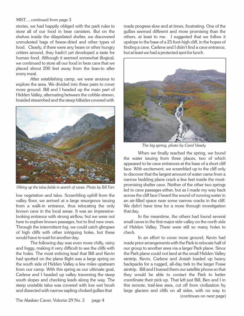
Hiking up the talus fields in search of caves. Photo by Bill Farr.
The big spring, photo by Carol Vesely.
The Alaskan Caver, Volume 29 No. 3 page 4
stories, we had happily obliged with the park rules to store all of our food in bear canisters. But on the shelves inside the dilapidated shelter, we discovered unmolested bags of freeze-dried and other types of food. Clearly, if there were any bears or other hungry critters around, they hadn't yet developed a taste for human food. Although it seemed somewhat illogical, we continued to store all our food in bear cans that we placed about 200 feet away from the lean-to after every meal.
After establishing camp, we were anxious to explore the area. We divided into three pairs to cover more ground. Bill and I headed up the main part of Hidden Valley, alternating between the cobble-strewn, braided streambed and the steep hillsides covered with
low vegetation and talus. Scrambling uphill from the valley floor, we arrived at a large resurgence issuing from a walk-in entrance, thus relocating the only known cave in the local areae. It was an impressive-looking entrance with strong airflow, but we were not here to explore known passages, but to find new ones. Through the intermittent fog, we could catch glimpses of high cliffs with other intriguing holes, but these would have to wait for another day.
The following day was even more chilly, rainy and foggy, making it very difficult to see the cliffs with the holes. The most enticing lead that Bill and Kevin had spotted on the plane flight was a large spring on the south side of Hidden Valley a few miles upstream from our camp. With this spring as our ultimate goal, Carlene and I headed up valley traversing the steep south slopes and checking leads along the way. The steep unstable talus was covered with low wet brush and dissected with narrow sapling-choked gullies that
made progress slow and at times, frustrating. One of the gullies seemed different and more promising than the others, at least to me. I suggested that we follow it upslope to the base of a 25 foot-high cliff, in the hopes of finding a cave. Carlene and I didn't find a cave entrance, but at least we had a protected spot for lunch.
When we finally reached the spring, we found the water issuing from three places, two of which appeared to be cave entrances at the base of a short cliff face. With excitement, we scrambled up to the cliff only to discover that the largest amount of water came from a narrow bedding plane crack a few feet inside the most-promising shelter cave. Neither of the other two springs led to cave passages either, but as I made my way back across the cliff face I heard the sound of running water in an air-filled space near some narrow cracks in the cliff. We didn't have time for a more through investigation that day.
In the meantime, the others had found several small caves in the first major side valley on the north side of Hidden Valley. There were still so many holes to check.
In an effort to cover more ground, Kevin had made prior arrangements with the Park to relocate half of our group to another area via a larger Park plane. Since the Park plane could not land at the small Hidden Valley airstrip, Kevin, Carlene and Josiah loaded up heavy backpacks for a rugged, all-day trek to the larger Fosse airstrip. Bill and I loaned them our satellite phone so that they would be able to contact the Park to better coordinate their pick up. That left just Bill, Ben and I in this remote, trail-less area, cut off from civilization by large glaciers and cliffs on all sides, with no way to
MIST..., continued from page 3

Faulty Fissure Cave, photo by Bill Farr.
Carol Vesely and Ben Tobin at the entrance to Faulty Fissure Cave.Photo by Bill Farr.
Bill Farr climbing into a high lead, photo by Carol Vesely.
(continues on next page)
The Alaskan Caver, Volume 29 No. 3 page 5
MIST..., continued from page 4
contact the outside world. Time to look for more caves! The rain and fog that had prevented us from
getting a clear view of the area over the last few days had partially cleared. We headed up the major side valley on the north side of Hidden Valley. Most of the holes that looked so promising from a distance, revealed themselves to be only frost pockets when viewed up close or in different light. Still there was a lot to inventory and check.
One particular hole, located about 30-40 feet up the cliff, appeared large enough and dark enough to warrant getting out the rope and climbing gear. Bill lead the climb, Ben belayed and I photographed and filled out the inventory sheet. Placing a few pieces of protection, Bill climbed up a narrow crack to discover a shallow cave with a ledge heading along the cliff on either side. We checked several other small holes along the base of the same southwest-facing cliff. Bill then followed various ledges towards the top of the cliff, while Ben and I headed farther up valley.
On the way back, I checked and inventoried another hard-to-get-to hole on the opposite side of the valley. Meanwhile, Ben revisited Foggy Crawl Cave and rediscovered his survey tape that had been accidentally left behind a few days before. With the low clouds gone for the first time, we were able to see across Hidden Valley, where we noticed an intriguing-looking horizontal gash at the base of a short cliff. This entrance did not have the standard rounded look of the typical frost pockets that were so plentiful in the area. Instead, it
looked more like an eastern cave, with a long, low entrance and a cobbled dry stream bed issuing from it. I noted that it was farther up the same gully that Carlene and I had checked earlier in the week.
The following day, Ben, Bill and I headed towards the entrance we had spotted at the end of the

The Alaskan Caver, Volume 29 No. 3 page 6
Ben Tobin and Bill Farr check out leads. Photo by Carol Vesely.
previous day. We easily found our way up and around the short cliff where Carlene and I had turned around before. The entrance was 8 feet high 20 feet wide and looked as though a small seasonal stream occasionally followed from it. A hole in the ceiling of the entrance room spiraled upwards to an ice plug. At the back of the room a narrow fissure stair-stepped its way up into the mountain. I pushed the last 15 feet of the passage as a constriction made it a bit too tight and twisty for Ben and Bill. Eventually, the passage broke into smaller tubes that were impassable. We surveyed Faulty Fissure Cave, yielding 110 feet of passage and pushed every hole before returning to base camp.
We awoke to the drone of a small plane and realized that a group of hunters had descended on "our" peaceful valley. In Alaska, hunting is allowed in portions of certain National Parks, but not in the most sensitive areas, referred to locally as the "hard park". I thought we would have to relinquish access to the little lean-to cook house, but the hunters established a luxurious tent camp near the airstrip instead. Their pilot and guide brought news of the outside world. He proudly proclaimed that Alaska governor Sarah Palin had been selected as John McCain's running mate. He also made it clear that he was not thrilled with our presence. Although, there were only three of us, he was very concerned that we would scare away the sheep and mountain goats that the hunters sought. Indeed, we had seen goats and sheep in the distance and plenty of droppings up close, particularly along the cliffs, but we hiked quietly and never got within a quarter mile of any significant wildlife. When I asked him about caves and springs, he suggested that we should return in the earlier part of the
year when the vegetation was less dense, (before hunting season).
. I felt that the spring Carlene and I had visited earlier deserved a return visit, so we headed up valley. Based on trial and error, we now knew the easiest stream crossings and the most efficient way up the trail-less valley, so our progress was much faster than earlier in the week. Once at the spring, we could hear water rushing beyond a narrow crack in the cliff face. We moved a few rocks to stabilize the loose cliff area, but ultimately determined that we were too big to follow the water into the hillside.
Whi le B i l l and Ben cont inued investigation of the spring area, I hiked uphill several hundred feet to check a lead I had spotted from a distance earlier. After a few interesting moves up a loose rock drainage, I reached the hole, which had a moss covered
floor and a small skylight in the back. It obviously served as a water course when the stream flowed down the gully. I inventoried it and heading back to the others. Then we all returned to base camp.
The following day, we were awakened by several gun shots in the distance. The hunting party had bagged their prize. We never actually saw them or their prey, but they were flown out later that day.
Since our time was limited and we still had so much ground to cover, we decided to split our efforts. Bill and Ben headed up the steep cliffs and hillsides on
the north side of the valley opposite our camp. I went in search along the major infeeder on the south side of Hidden Valley, just downstream of camp. As with other places where we had ridgewalked earlier, this valley had no significant cave features near the bottom, but many
MIST..., continued from page 5
Double rainbow over Hidden Valley, Photo by Bill Farr.
(continues on next page)
The Alaskan Caver, Volume 29 No. 3 page 7
MIST..., continued from page 5
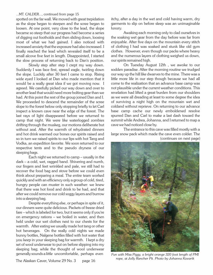
Participants from left: Steve Lewis, Johanna Kovarik Gwen Herrewig and Carlene Allred. Nick Olmstead is to the right, and just out of the picture. Photo by K. Allred.
by Carlene AllredDigital Cartography Workshop
enticing holes along its steep sides and cliffs. I climbed up to two of the most promising-looking ones and inventoried them.
From my vantage point, high along the east side of the valley, I could see upstream a long way. The valley became broader and flatter; the gently-rolling terrain covered with low vegetation with very few rock outcrops. I scanned the area with my binoculars, but nothing cried "cave" from my vantage point. It was late, so reluctantly I headed back through the drizzle to camp.
Carlene, Kevin and Josiah had arrived full of tales of their adventures. The Park plane had not been able to land at the Fosse airstrip, because it was too soggy. Fortunately, the Fosse area itself had plenty of interesting caves and features to document, including a 150 foot-deep pit with fantastic ice formations! With so much to do in the Fosse area, they wished they had been able to contact us to tell us to join them.
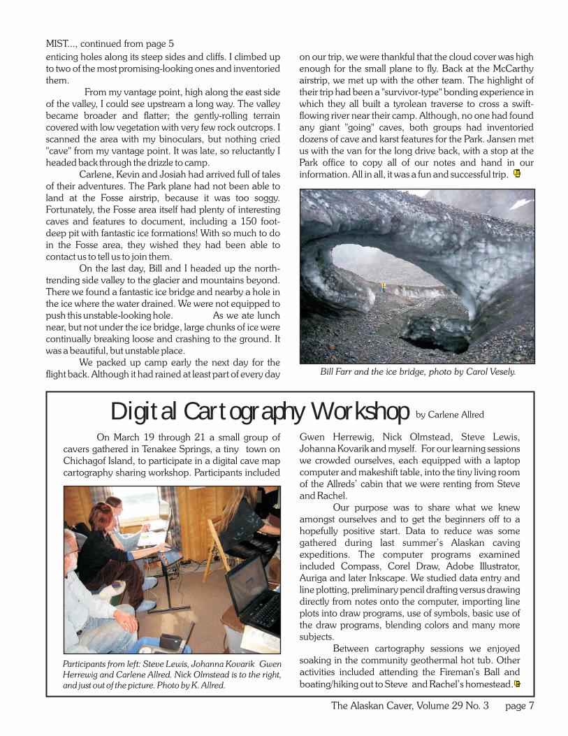
On the last day, Bill and I headed up the north-trending side valley to the glacier and mountains beyond. There we found a fantastic ice bridge and nearby a hole in the ice where the water drained. We were not equipped to push this unstable-looking hole. As we ate lunch near, but not under the ice bridge, large chunks of ice were continually breaking loose and crashing to the ground. It was a beautiful, but unstable place.
We packed up camp early the next day for the flight back. Although it had rained at least part of every day
on our trip, we were thankful that the cloud cover was high enough for the small plane to fly. Back at the McCarthy airstrip, we met up with the other team. The highlight of their trip had been a "survivor-type" bonding experience in which they all built a tyrolean traverse to cross a swift-flowing river near their camp. Although, no one had found any giant "going" caves, both groups had inventoried dozens of cave and karst features for the Park. Jansen met us with the van for the long drive back, with a stop at the Park office to copy all of our notes and hand in our information. All in all, it was a fun and successful trip.
On March 19 through 21 a small group of cavers gathered in Tenakee Springs, a tiny town on Chichagof Island, to participate in a digital cave map cartography sharing workshop. Participants included
Gwen Herrewig, Nick Olmstead, Steve Lewis, Johanna Kovarik and myself. For our learning sessions we crowded ourselves, each equipped with a laptop computer and makeshift table, into the tiny living room of the Allreds’ cabin that we were renting from Steve and Rachel.
Our purpose was to share what we knew amongst ourselves and to get the beginners off to a hopefully positive start. Data to reduce was some gathered during last summer’s Alaskan caving expeditions. The computer programs examined included Compass, Corel Draw, Adobe Illustrator, Auriga and later Inkscape. We studied data entry and line plotting, preliminary pencil drafting versus drawing directly from notes onto the computer, importing line plots into draw programs, use of symbols, basic use of the draw programs, blending colors and many more subjects.
Between cartography sessions we enjoyed soaking in the community geothermal hot tub. Other activities included attending the Fireman’s Ball and
boating/hiking out to Steve and Rachel’s homestead.
Bill Farr and the ice bridge, photo by Carol Vesely.

The Alaskan Caver, Volume 29 No. 3 page 8
Photo by Bill Farr
FAULTY FISSUREWRANGELL-SAINT ELIAS NATIONAL PARK
ALASKA
Surveyed with compass, clinometer and tape September 1, 2008 by Carol Vesely, Ben Tobin and Bill Farr.
Map by C. Vesely and C. Allred.
Surveyed length: 110 feet 33.5 metersSurveyed vertical extent: 16 feet (4.9 meters)
( )
TONGASS CAVE PROJECT
PROFILE
PLAN
Entrance
0 datum
0 datum
Entrance
0 20feet10
0 meters 5
ice popcorn
ice flow
too tight
too tight
too tight
air and ice comingout of fracture
NNm 21.9 2008
LEGEND
passage wall
slope (splays downward)
vertical drop
change in ceiling height
bedrock floor
rock fill
vegetation
5
15
10
-5
0 datum
C 2009 by Carlene Allred
feet

The Alaskan Caver, Volume 29 No. 3 page 9
DESCRIPTIONFaulty Fissure Cave was discovered on August 31,
2008 by Ben Tobin, Carol Vesely, and Bill Farr. It was surveyed by them on Sept. 1, 2008. The entrance is located at the base of a 35 foot high Chitistone Limestone cliff. A dry streambed heads downhill from the entrance. The cave floor consists of small breakdown. A slight draft of cold air comes out of the cave, and there is evidence that some water resurged in the past.
After entering the large 27 foot wide by eight foot high entrance, the broad passage leads over breakdown to a 20 foot high chimney near the middle of the room. This chimney contains some ice popcorn. Flow ice and a draft of air was coming out of a too tight fracture. To the east of the chimney is a small alcove. The main passage continues another 20 feet past a place in the floor where water sinks and then to a dead end. Just before the back, another chimney/climb heads up to the west. This is a 15 foot climb containing small cave coral speleothems (branching popcorn) which leads to a horizontal passage containing several side branches which all become too tight.
MANAGEMENT RECOMMENDATIONSAs Faulty Fissure Cave is very remote, it is not likely
to be impacted by much if any visitation. Prospects are poor to extend the cave.
References: Carol Vesely, 2008 inventory sheet. Ben Tobin, 2008 cave inventory sheet, Carol Vesely, 2008 cave survey notes.
DESCRIPTIONFoggy Crawl Cave is located on the north side of
Hidden Creek. It was discovered and surveyed on August 28, 2008 by Josiah Huestis and Ben Tobin. The cave is a small
hole in the last set of lower cliffs before major moraines. It is formed in Chitistone Limestone.
The cave is a simple s-shaped horizontal passage that snakes nearly 20 feet (6.02 meters) until becoming too tight. A rodent nest was noted about 15 feet (five meters) into the cave. A possible moth larvae was found in the floor rocks about 12 feet (four meters) in.
The paleo flow of this cave during its development was inward judging from scallops. No air flow was reported.
MANAGEMENT REOMMENDATIONSNo special management is needed for this cave.
DESCRIPTIONOn August 28, 2008, Josiah Huestis and Ben Tobin
discovered and surveyed Hibernation Hole. Formed in Chitistone Limestone, Hibernation Hole extends to the west only 23.2 (7.1 meters). Nearly horizontal, despite extensive frost shattering, the cave appears to have phreatic origins. The cave retains roughly the same dimensions most of it's length from the three foot high and five foot wide entrance.
BIOLOGYHibernation Hole has been used in the past as a
hibernacula, judging from numerous bear bones scattered in and on the floor sediments. A depressed bear bed had been excavated near the back of the cave. Ben Tobin removed a small fragment of bone for dating through the University of Alaska Juneau. It was dated by Beta Analytic Inc. of Miami Florida as between 1650 and 1890 AD. The cave could have more potential to provide some insight as to at least one window of deglaciation in the area. No invertebrates were noted.
MANAGEMENT RECOMMENDATIONS
Though seemingly insignificant, Hibernation Hole has the potential of being a significant paleontological time capsule. The location should remain confidential and the cave protected under the Federal Cave Resource Protection Act of 1988.
WRANGELL-ST. ELIAS NATIONAL PARK, ALASKA
TONGASS CAVE PROJECTPreliminary Report #WS12 by Kevin Allred
Feb. 11, 2009
FAULTY FISSURE CAVE
WRANGELL-ST. ELIAS NATIONAL PARK, ALASKATONGASS CAVE PROJECT
Preliminary Report #WS11 by Kevin AllredJuly 7, 2009
HIBERNATION HOLE
WRANGELL-ST. ELIAS NATIONAL PARK, ALASKA
TONGASS CAVE PROJECTPreliminary Report #WS15 by Kevin Allred
Feb. 9, 2009
FOGGY CRAWL CAVE

The Alaskan Caver, Volume 29 No. 3, page 10
PROFILE
entrancenest
0 datumtoo tight
too tight
FOGGY CRAWL CAVEWRANGELL-SAINT ELIAS NATIONAL PARK
ALASKA
Surveyed with compass, clinometer and tape August 28, 2008 by Josiah Huestis and Ben Tobin.
Map by K. and C. Allred.
Surveyed length: 19.7 feet (6.02 meters)Surveyed vertical extent: 1.4 feet (.45 meters)
TONGASS CAVE PROJECT
PLAN
0 datum
entrance
paleo direction from scallops
10feet
5
0 meters 5
200
C 2008 by Carlene Allred
nest
LEGEND
passage wall
rock fill
silt or dirt fill
slope (splays downward)
opening in wall
entrance driplineinout
Nm 21.9 2008
N
10feet
5
0 meters 5
200
C 2009 by Carlene Allred
HIBERNATION HOLEWRANGELL-SAINT ELIAS NATIONAL PARK
ALASKA
Surveyed length: 23.2 feet (7.1 meters)
TONGASS CAVE PROJECT
Surveyed with compass, clinometer and tape August 28, 2008 by J. Huestis and B. Tobin. Map
by K. and C. Allred.
PLAN
entrance
PROFILE
entrance
LEGEND
passage wall
rock and finer sediment fill
slope (splays downward)
entrance dripline
change in ceiling height
major bear bone locations including partial skull, teeth and partial femur
sky
higherNm 21.9 2008
N

The Alaskan Caver, Volume 29 No. 3 page 11
SHELTER SPRING CAVEWRANGELL-SAINT ELIAS NATIONAL PARK
ALASKA
Surveyed with compass, clinometer and tape August 28, 2008 by J. Huestis and B. Tobin. Map by
K. and C. Allred.
Surveyed length: 14.3 feet (4.4 meters)
TONGASS CAVE PROJECT
C 2009 by Carlene Allred
10feet
5
0 meters 5
200
PLANentrance
spring
PROFILE
entrance
spring
LEGEND
passage wall
rock fill
slope (splays downward)
entrance driplinesky
Nm 21.9 2008
N
Photo by Josiah Huestis
PLAN
too tight
paleo flow direction indicatedfrom scallops on walls
rodent nest
entrance
C 2009 by Carlene Allred
PALEO CRAWLWRANGELL-SAINT ELIAS NATIONAL PARK
ALASKA
Surveyed with compass, clinometer and tape August 27, 2008 by B. Tobin. Map by K. and C. Allred.
Surveyed length: 16.5 feet (5 meters)
TONGASS CAVE PROJECT
PROFILE
too tightentrance
rodent nest
LEGEND
passage wall
rock and rubble fill
slope (splays downward)
entrance dripline
change in ceiling height
sky
higher
Nm 21.9 2008
N
10feet
5
0 meters 5
200
photo by Josiah Huestis

The Alaskan Caver, Volume 29 No. 3, page 12
ALASKA
0 100
Kilometers
PRINCE
OF WALES
ISLAND
PACIFIC
OCEAN
MOUNT CALDER
...MT. CALDER..., continued from page 2
DESCRIPTIONPaleo Crawl Cave was surveyed and discovered by
Ben Tobin and Josiah Huestis on August 27, 2008. Located at the base of a Chitistone Limestone cliff above a high steep slope on the north side of Hidden Valley, the cave is just west of "Double Spring", which issues from under a small overhang. The arched entrance is about 2.2 feet (.7 meters) wide by 3.3 feet (1 meter) high. It contains dripping water and a small rodent nest in an alcove on the east side. The cave becomes too tight after only 16.5 feet (5.05 meters).
MANAGEMENT RECOMMENDATIONSNo special management should be needed for this
cave.
WRANGELL-ST. ELIAS NATIONAL PARK, ALASKA
TONGASS CAVE PROJECTPreliminary Report #WS14 by Kevin Allred
Feb. 9, 2009
PALEO CRAWL CAVE
DESCRIPTIONShelter Spring Cave was discovered and surveyed
by Ben Tobin and Josiah Huestis on Sept. 28, 2008. It is at the top of some talus and base of a cliff.
The cave appears to have formed principally by frost action where the spring emerges from the bedrock. Directional popcorn can be found inside. Most of the cave is open to the outside as a wide overhang, but at the southern end the spring emerges from the back of a short passageway. Total survey was 4.55 meters (14.9 feet).
MANAGEMENT RECOMMENDATIONSShelter Spring is not likely to ever be visited again
or impacted by the public.
WRANGELL-ST. ELIAS NATIONAL PARK, ALASKATONGASS CAVE PROJECT
Preliminary Report #19 by Kevin AllredFeb. 11, 2009
SHELTER SPRING CAVE
bunk house we made the short walk to Johanna's apartment where I had the pleasure to meet the rest of the expedition members.
Johanna's apartment in the Forest Service compound had an amazing view of Thorne Bay. The evening sun seemed to hang in the amber glow of a summer sunset for hours, allowing one to view the float planes landing and taking off upon the still water of the bay. I briefly called home and wished my wife, Jade goodnight – for it was late at night in Tennessee, though the sun was just setting in Alaska – before returning to the group to introduce myself. Dan Monteith, who was leaving the expedition, was a pleasure to become acquainted with. The only other member of the team that I had not met before was Carl Bern, a Colorado caver and mountaineer who was a powerhouse when in the alpine on Mt. Calder. The remaining members of the group included Andrea Croskrey, an experienced expedition caver I first met at South Pittsburg Pit after the 2005 TAG Fall Cave-in; and Dan Nolfi, another caver with expedition experience whom I had caved several times. Dan was also the only other member from the TAG area. Concluding our team was Johanna Kovarik, fiery redhead, steadfast expedition leader and a good friend. (continues on next page)

The Alaskan Caver, Volume 29 No. 3 page 13
Mt. Calder when the weather is pleasant. Photo from thePanoramia website, by Gogrimm.
Johanna I also met after the 2005 TAG Fall Cave-in. She had returned to TAG a few months later with her grotto and I had the pleasure of leading the group through a few caves in my area. Over the past few years Johanna, Dan Nolfi, and I found ourselves caving together in TAG and also at the Cave Research Foundation (CRF) Expeditions in Cumberland Gap National Historic Park, Kentucky. For a few of us, this evening was about catching up on old times, and for the rest of the group, beginning to make new memories with new friends.
We all shared stories over Dan Monteith's awesome homemade pizzas and loosened our tongues with margaritas, my specialty. I am a TAG caver so margaritas come naturally to me. It was either the tequila or the excitement of the adventure to come that kept us awake late into the night and well into the early morning.
Finally the lack of sleep took its hold and I dragged my weary feet across the darkened Forest Service compound to my room in the bunk house. Surprisingly, sleep did not immediately follow, and I lay awake pondering the day's events. My first day in Alaska was behind me and I knew a big day of preparing gear would be here earlier than I would like. I looked forward to the next day and that week with hope and excitement, but my mind's eye also couldn't help but focus on the longing only a man with a family left behind could understand: if all went well, it would be over a week before I saw them again; as with any expedition, and especially an Alaskan expedition, there was, of course, the possibility that all would not go well.
APPROACHING MOUNT CALDERThe next morning, August the 8th was primarily
spent preparing gear and packing up Johanna's little SUV and "The Wolverine". The Wolverine was an old model Suburban with its characteristic moniker painted across the bug shield, which had been rented from local caver Pat Tierney. After printing aerial photos of Mt. Calder and double checking the tire pressure in the vehicles, we loaded up and embarked towards the north end of Prince of Wales Island in the early afternoon summer sun.
Our destination for the day was Memorial Beach, the northern terminus of the island and located just east of Mt. Calder. The drive along the extensive Forest Service-maintained roads that crisscross the Tongass National Forest took about four hours and I saw some of the densest forest that I have ever experienced. It was along this drive that I was first introduced to salmon berries, which look like huge blackberries that
can either be yellow or red in color. I also had the pleasure of experiencing thimble berries, a sweet red berry, along with a large amount of blueberries.
After a few hours of traveling the dusty roads and the occasional berry stop, we arrived at Memorial Beach as dusk approached. From the parking area, a short hike through a stand of massive spruce led us to one of the best campsites I have ever seen. Within the shelter of the primordial spruce stand was an incredible campsite covered in a thick moss that felt like a mattress when walked upon. One would only have to hop across a few bleached driftwood logs to reach the pebble stone beach and the gentle waves of the salty Pacific. Killer whales could be heard and seen spouting a few hundred feet from shore. We arrived to a spectacular sunset that, in true Alaskan fashion, lingered longer than seemed possible, enough for us to exhaust our need to capture the magical scene in digital form and also enable us to set camp.
We then roasted some delicious bratwurst in the fading glow of the setting sun on a driftwood fire still blazing from the group that had left as we arrived. These delicious brats were accompanied by some welcome ale from the Alaskan Brewing Company. As night fell our spirits rose and the storytelling became more elaborate, more entertaining.
At some point I noticed a strange glow emanating from the night sky over the bay. To our delight we began holding witness to one of nature's most spectacular scenes: the Aurora Borealis flared to life in a vibrant blue green above Memorial Bay just above the humpback whales playing in the water below, a sight I will never forget. As the scene faded and the night grew late we retired to enjoy the mossy earth
APPROACHING MOUNT CALDER
(continues on next page)
...MT. CALDER..., continued from page 12

The Alaskan Caver, Volume 29 No. 3 page 14
beneath our tents and I to my journal, as would become my nightly ritual for the remainder of the expedition.
The following day we awoke to a fog that had crept in during the night. The low ceiling made it impossible for the helicopter that we were to meet at Labouchere Bay. After waiting for most of the morning, Johanna made the call to hold until the next day. We decided not to waste the day and ridge walked a lower ridge of Mt. Calder that looked promising. To bushwhack through boreal rainforest is an experience in itself. Between the devil's club and dense undergrowth a feeling of timelessness creeps upon you. The forest floor is crisscrossed by numerous ancient game trails that at times are the easiest if not only means of travel. There seemed to be leads with every glance yet none upon closer examination yielded anything worth note.
While Carl and I made our way back to the "Wolverine", Johanna came over the radio that she, Dan, and Andrea located two caves; the first was located at the base of a cliff and the other was small slot to a 15 foot drop. Other than the few leads that were found the main catch of the day was a blueberry branch I snagged, which yielded a full liter of blueberries that we decided would be perfect for some blueberry pancakes the next morning.
That night, unfortunately, we were not blessed with the Aurora Borealis, but we did get to behold yet another wonder of nature: as Carl washed for bed in the cold pacific he was stunned to notice the water when agitated by his hands and the gentle lapping of the waves upon the pebble stones of the beach would sparkle and glow a blue-green light. We all spent the next hour or so marveling at the phospholuminescent algae. By the time we all stumbled back into bed our hands and feet were numb from the frigid water, but we were grateful to have been able to experience the natural wonders of the past two nights.
The next day was Sunday, August 10th and our last chance to get up Mt. Calder. The morning started early with blueberry pancakes and we prepared the gear for the helicopter ride in the early morning sunlight. It was Calder or bust and when we saw our window we did not waste time. Johanna made the call on the radio and we drove the short distance to Labouchere Bay to the rendezvous spot. The heli arrived shortly and within the hour we had all been briefed on how the operation would take place. We would go up in four flights. Johanna and Dan would go first scouting a spot for our base camp and doing quick recon. The next flight would be the remainder of the team. The third flight would have an internal load of gear that we would unload
...MT. CALDER..., continued from page 13
(continues on next page)
quickly so the heli could return with the sling load. After that we would be on our own.
Everything went smoothly, and before long we were listening to the fading 'whomp-whomp' of the chopper blades as our last connection to the rest of the world disappeared into the horizon.
LAYING SEIGE TO THE MOUNTAINWe had originally planned to set up camp on the
summit of Mt. Calder, but due to limited visibility, high winds, and time we got as far as a muskeg, which is basically an alpine swamp, only partially up the mountain. We set up camp and with the few hours of day light left and the weather still fairly decent we humped some gear up a steep slope to an alpine scrub ridge which snaked its way towards the summit. This was to become our morning ritual climb for the remainder of our time on Calder.
The alpine scrub was dense and the ridge was narrow and exposed on one side by a huge vertical cliff a few thousand feet tall bottomed, by a massive scree bowl. The other side was steep and densely forested. The ridge formed a horseshoe around a glacial scree bowl. On one side was our camp and on the other rose the summit of Mt. Calder. The ridge was riddled with karst topography. Unfortunately, the freeze-thaw action of the Alaskan climate had worked its magic on the massive block of limestone that formed Mt. Calder and clogged most of the holes with debris. The terrain was extremely slow to navigate, mostly covered with alpine
LAYING SEIGE TO THE MOUNTAIN

The Alaskan Caver, Volume 29 No. 3 page 15
scrub hiding numerous holes that were quick to swallow anyone not paying proper attention to the ground beneath their feet. Returning to camp that night we held a renewed respect for the mountain we had laid siege to. Tomorrow our work would really begin.
At some point during that first night the rain began. Not a downpour or a torrent, but a light rain which was little more than a mist. This, however, was deceiving. The rain would continue for the remainder of the expedition. Before long everything was completely soaked through. The only relief from the wet chill was late at night in our sleeping bags, and even then we were still slightly damp. Awakening that first morning on Mt Calder was an experience. My feet and hands were swollen but slowly I rose to the dampness that would become my life for the next few days. Slogging over from our various corners of the muskeg to the cook area, the team begun to boil water for a few cups of coffee apiece and then for four or five packets of instant oatmeal and maybe some hot chocolate. Over this simple, filling meal the agenda for the day was discussed. Afterward we collected the food we would need for the day before repacking everything into the giant food bags and re-hanging them in the tree to keep out the bears, which were always at the back of our minds. As can be expected the morning routine was punctuated by trips to the latrine w h i c h I h a d thank fu l l y dug , along with Johanna m y f a i t h f u l supervisor, the first day at camp before the rain had begun.
Before long we organized and our sodden feet stomped their way u p t h e h i l l , a mountain itself back i n TAG, wh i ch loomed above our camp. From there we followed our trail from the evening before past the numerous holes that were all to frequent. We emerged from the boreal forest to a stinging cold mist that greeted us as we summated the ridge and past the open air pit we had noticed the previous day. Our
party trudged slowly and wound our way along a knife edge ridge flanked only by a mist that hid the thousands of feet of sheer vertical limestone wall to the scree bowl below. Eventually we made our way to an obstacle we had named the evening before.
The 'Hillary Step' rose like a giant shoulder of rock blocking our already treacherous path. We had named the obstacle for a similar obstacle located on Mount Everest. Beyond this we experienced more of the same alpine scrub but with more room to wander as the ridge had widened and was now punctuated by bare rock and sinks. At this point the weather worsened and our spirits fell. We decided to stash a large amount of rope and gear at a small depression offering at least a minimum of protection from the wind for an advance base camp on the following day. From here we made a decision to retreat down the mountain while investigating new ground for caves via a scree slide into to scree bowl below and over to our camp.
This was a slow and tedious process as the slope was extremely steep and the scree was loose enough that many times an errant stone would tumble only to gain momentum and other stones that painted a vivid picture on what would happen if we were to follow the same
fate. The debris at the bottom a few thousand feet below w a s e v i d e n c e enough that the possibility of a large slide was all too real. D a n a n d C a r l checked a short lead that did not go and we preceded down the slide into the bowl below. Upon reaching the edge of the bowl we began our traverse towards our camp. At one point we crossed a large snow pack that resembled a small glacier. On the other side of this obstacle a
small opening was spotted above us. Carl, Andrea, and Johanna went to investigate where they survey a short horizontal cave around 50 ft in length.
Meanwhile, Dan and I traversed the horseshoe shaped glacial scree bowl toward a lead that we had
...MT. CALDER..., continued from page 14
(continues on next page)
The Alaskan Caver, Volume 29 No. 3 page 16
Fun with Miss Piggy, a bright orange 320 foot length of PMIrope, at Jolly Rancher Pit. Photo by Johanna Kovarik
spotted on the far wall. We moved with great trepidation as the slope began to steepen and the scree began to loosen. At one point, very close to the lead, the slope became so steep that our progress had become a series of digging out footholds and then sliding down, loosing most of what we had gained. I also noticed with increased anxiety that the exposure had also increased. I finally reached the lead which revealed itself to be a small alcove five feet in length. Disappointed, I started the slow process of returning back to Dan's position.
Slowly step after step I crept my way down. Suddenly I was face first, spread eagle, twirling down the slope. Luckily after 30 feet I came to stop. Rising wide eyed I looked at Dan who made mention that it would be a really great idea if we got moving now. I agreed. We carefully picked our way down and over to another lead that would need more bolting gear than we had. At this point the rest of the group joined Dan and I. We proceeded to descend the remainder of the scree slope to the forest below only stopping briefly to let Carl inspect a known cave near the edge of the forest. The last rays of light disappeared before we returned to camp that night. We were like waterlogged zombies drifting through the muskeg, our motions deliberate but without zeal. After the warmth of rehydrated dinners and hot drink warmed our bones our spirits raised and so in turn we raised spirits to our lips with hot Tang and Vodka, an expedition favorite. We soon returned to our respective tents and to the pseudo dryness of our sleeping bags.
Each night we returned to camp – usually in the dark – a cold, wet, ragged band. Shivering and numb, our fingers and feet wrinkled and pale, we still had to recover the food bag and stove before we could even think about preparing a meal. The entire team worked quickly and with an efficiency only a group of cold, tired, hungry people can muster in such weather: we knew that there was hot food and drink to be had, and that after we could remove our cold soggy layers and burrow into a sleeping bag.
Despite everything else, or perhaps in spite of it, our dinners were quite delicious. Packets of freeze dried fare – which is labeled for two, but it seems only if you're on emergency rations – we boiled in water, and then held under our wet clothes next to our chests for the warmth. After eating we usually made hot tang or other hot beverages. On the really cold nights we made bunny bottles, Nalgene bottles filled with hot water that you keep in your sleeping bag for warmth. I kept a dry set of wool underwear to put on before slipping into my sleeping bag; while the thought of wool underwear generally sounds a little uncomfortable, perhaps even
itchy, after a day in the wet and cold having warm, dry garments to slip on before sleep was an unimaginable luxury.
Awaking each morning only to clad ourselves in the soaking wet gear from the day before was far from enjoyable. After five days on the mountain every stitch of clothing I had was soaked and stunk like old gym clothes. However, even though our packs where heavy and the numerous layers of clothing weighed us down, our spirits remained high.
On Tuesday August 12th , we awoke to our sodden paradise. After the morning routine we trudged our way up the hill like dwarves to the mine. There was a little more life in our step though because we had all come to the realization that an advance base camp was not plausible under the current weather conditions. This revelation had lifted a great burden from our shoulders as we were all dreading at least to some degree the idea of surviving a night high on the mountain wet and coldand without reprieve. On returning to our advance base camp cache our newly emboldened resolve spurred Dan and Carl to make a last dash toward the summit while Andrea, Johanna, and I returned to map a cave we had noticed close by.
The entrance to this cave was filled mostly with a large snow pack which made the cave even colder. The
...MT. CALDER..., continued from page 15
(continues on next page)

The Alaskan Caver, Volume 29 No. 3 page 17
...MT. CALDER..., continued from page 14
cave turned out to be only 35 feet in length with a small amount of bones noted within.
Shortly, Dan and Carl returned humbled as we all were by Mt. Calder in the rages of a southeast Alaskan storm. We made our way back towards camp stopping twice; once to check a karst feature with a very cool canyon entrance, and to stash gear at an open air pit we were to survey the next day.
On our last full day on Calder we surveyed the pit close to camp, a cold 50 footer that we had to bolt and was almost entirely filled with a column of snow. This would be nothing special back home, but few if any TAG pits are filled mostly with a large column of snow or located in such a remote area.
While we were busy with this, Johanna and Dan located another pit on the southern slope of Calder which turned out to be a 70 foot classic we dubbed Jolly Rancher Pit in honor of the piece of candy Johanna hadgiven me before I made the first descent.
The weather had beaten us down and we knew we were not going to make it to our objective. We had planned on getting to the summit area where a 100 foot pit named "Chopper Bopper" with good vertical leads had been previously located. This area was scouted by Johanna and Dan on the way up in the heli and had numerous large sinks, all of which we were unable to reach due to the inclement weather.
All the activity mentioned above occurred at the top of three thousand foot limestone slab that comprises the majority of Mt. Calder, and from the nature of the terrain, how many possibilities we saw, and how little we were able to fully explore, I believe we only scratched the surface of Calder's potential and many more discoveries are yet to be had. At the ends of the earth every experience is heightened – pancakes taste better, company is more amiable, caves are, if this is even possible, somehow more alluring. For many of us, that sense of wildness is what lured us underground in the first place.
THE LONG TRIP HOMEOn the morning we were to leave Mt. Calder the
weather did not clear and the helicopter was unable to retrieve us or our gear. We made the decision to pack out only our essentials and leave the remainder of our gear on the mountain. We bushwhacked down until finally reaching an old logging road which we followed to Johanna's stashed vehicle.
We retrieved "The Wolverine" at Lebouchere Bay and made quick time back to Thorne Bay only to find out that no flights were leaving the island. I had no
THE LONG TRIP HOME
way back to Ketchikan or my flight to Seattle. That flight was cancelled as well, so it mattered little that I could not make my way to Ketchikan. The true hassle took place over the next several hours arguing with airlines trying to find some way to get back home. The remainder of the expedition team had to prepare for a Rescue workshop as best they could, since most of their gear was still soaking up on Mt. Calder.
Finally, the next day on Friday August 15th the weather cleared a bit and Johanna got a call that they had a flight ready for me, but I had to be at the dock in fifteen minutes or the plane would leave without me. Luckily, my bag was already packed and I had taken the opportunity the night before to get a well deserved shower and to wash my clothes in the Forest Service Bunk house. I hurried through goodbyes that were scarcely adequate at expressing all that our team had shared and endured over those days on the mountain, then hopped on the float plane back to civilization – or as near to it as one can find in Alaska.
In Ketchikan I met a local caver named Bruce White who was nice enough to let me stay at his house until I found a flight back home. I was able to do a little sea kayaking at the White's home as they have a wonderful cabin right on the water. Mr. White is not only a caver but a fisherman who owns several boats and to my delight several freezers stocked with fish. On the day that I left Bruce gave me a large bag full of fish that I and my family heartily enjoyed. It took two more days until I made it home to Tennessee where I was elated to be happily greeted by my wonderful wife and children that I had missed terribly.
When I look back on the journey and all the places I saw along the way, I realize the truth in that old Taoist saying. Though we did not complete our initial objective, I by no means consider the trip a failure; quite the opposite, in fact, I would call it a monumental success. For nearly a week there existed only ourselves and the mountain, and she permitted us a glimpse at some of her wonders. All in all, the journey was the destination.
Editor's Notes: The tough cavers on this expedition hacked out over 40 kilometers of hiking apiece through thick vegetation in mountainous country with heavy loads over the four days up on Mt Calder – locating five virgin caves in wind driven rain and cold mist. The Calder area still calls from North Prince of Wales Island with plenty of limestone left to investigate! The expedition would like to acknowledge the Dogwood City Grotto, the Tongass Cave Project of the NSS, and the NSS Sara Corrie Memorial Fund for expedition funding. Logistical support was provided by Backpacker's Pantry, Bruce White, NSS #39223, and Pat Tierney, NSS #33898. Thanks to all!

The Alaskan Caver, Volume 29 No. 3 page 18

The Alaskan Caver, Volume 29 No. 3 page 19
Published: April 9, 1885
Copyright © The New York Times

Address Service Requested
The Alaskan Caverc/o Carlene AllredGen. Del.Tenakee Springs, AK 99841