Embed Size (px)
Citation preview
Copyright © by Holt, Rinehart and Winston. All rights reserved.
112 Africa
Name Class Date
West Africa Geography and History
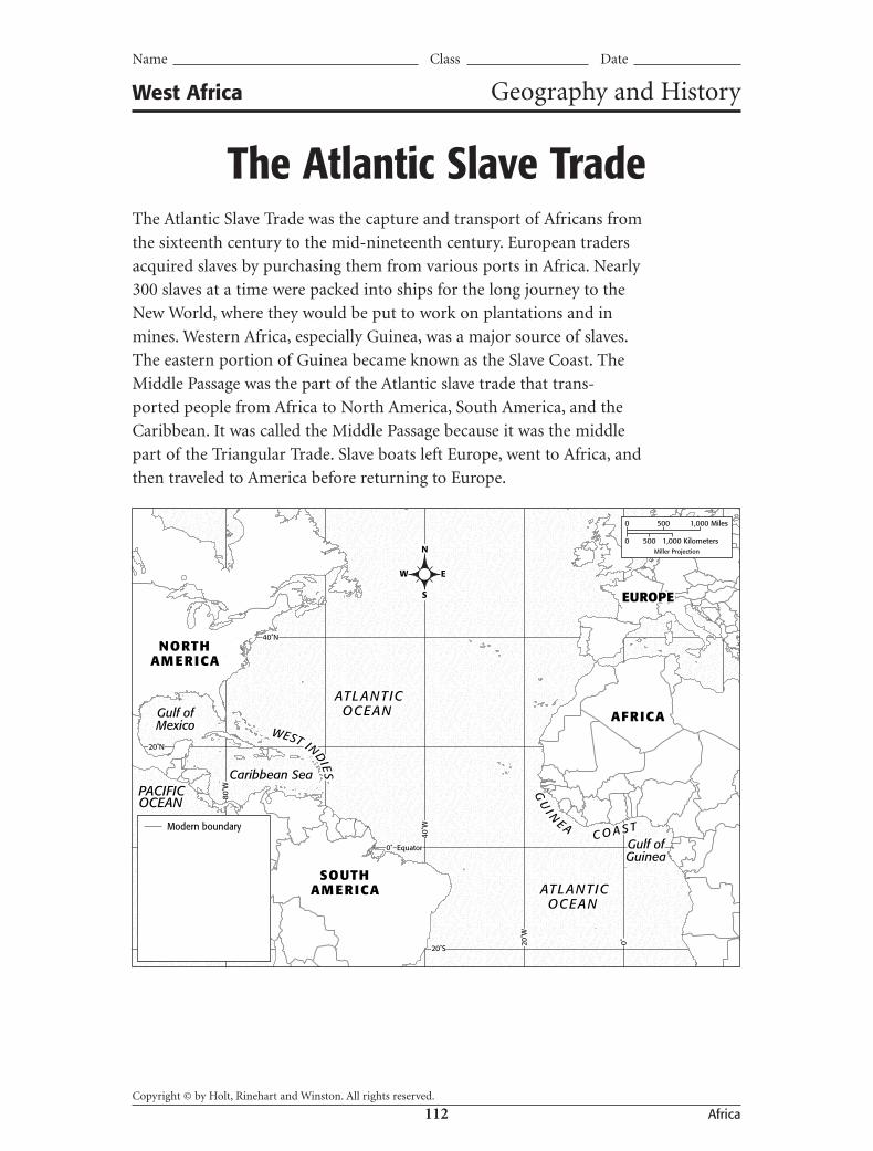
The Atlantic Slave TradeThe Atlantic Slave Trade was the capture and transport of Africans from
the sixteenth century to the mid-nineteenth century. European traders
acquired slaves by purchasing them from various ports in Africa. Nearly
300 slaves at a time were packed into ships for the long journey to the
New World, where they would be put to work on plantations and in
mines. Western Africa, especially Guinea, was a major source of slaves.
The eastern portion of Guinea became known as the Slave Coast. The
Middle Passage was the part of the Atlantic slave trade that trans-
ported people from Africa to North America, South America, and the
Caribbean. It was called the Middle Passage because it was the middle
part of the Triangular Trade. Slave boats left Europe, went to Africa, and
then traveled to America before returning to Europe.
ATLANTICOCEAN
ATLANTICOCEAN
PACIFICOCEAN
Caribbean Sea
Gulf ofMexico
Gulf ofGuinea
GU
I N
E A C O A S T
WEST INDIES
EUROPE
AFRICA
NORTHAMERICA
SOUTHAMERICA
20˚S
80˚W
20˚W
40˚W
0˚
40˚N
Equator0˚
20˚N
N
W E
S
Modern boundary
0 500 1,000 Miles
0 500 1,000 KilometersMiller Projection
MapQuest.Com, Inc.
mg7crf_wafgah004maWorld Political
Vital Information Area: 34p6 wide X 26p deep
3rd proof date: 11/28/05
5800_MSG_GeoHist_WAF.indd 112 12/21/05 11:45:58 AM

Copyright © by Holt, Rinehart and Winston. All rights reserved.
13 West Africa
Name Class Date
The Atlantic Slave Trade, continued Geography and History
MAP ACTIVITY
1. Use a red pencil or marker to shade the Slave Coast.
2. Use a blue pencil or marker to show a possible route of the Middle Passage.
3. Use a green pencil or marker to show an approximate route of the Triangular Trade.
4. Update the map legend to reflect the colors you added to the map.
ANALYZING MAPS
1. Place Why was the triangular Atlantic trade was considered the most important and profitable trading route in the world?
2. Movement The Gulf Stream is a powerful current in the Atlantic Ocean that begins in the Gulf of Mexico and flows in a northeasterly direction. Which part of the Triangular Trade would have been helped by the Gulf Stream?
3. Evaluate In many cases, Africa natives captured fellow Africans to sell as slaves to European traders. Does this surprise you? Why or why not?
5979_MSG_GeoHist_WAF.indd 135979_MSG_GeoHist_WAF.indd 13 1/14/06 9:02:53 AM1/14/06 9:02:53 AM

Copyright © by Holt, Rinehart and Winston. All rights reserved.
27 West Africa
Vocabulary BuilderSECTION 1 1. zonal 2. Sahel 3. Niger River 4. delta 5. Sahara 6. irregular rainfall, area of tall grasses,
scattered trees and shrubs 7. most important river in West Africa, flows
2,600 miles, empties into the Gulf of Guinea 8. organized by zone, east to west bands,
describes climates in West Africa
SECTION 2 1. F; archaeology 4. F; extended family 2. F; Timbuktu 5. T 3. TSummaries will vary but should correctly use at least five words from the word bank.
SECTION 3 1. Cape Verde 4. Lagos 2. famine 5. secede 3. Togo
BiographyQUEEN AMINA OF ZARIA
WHAT DID YOU LEARN? 1. possible answer —She learned from
her warriors; she led many military expeditions.
2. possible answer —She wanted to gain as much wealth for her country and people as possible.
ACTIVITYAnswers will vary, but students may mention conquering enemy troops, ensuring trade, providing food and water for their people, expanding the region’s boundaries, or building strong walls.
BiographyKWAME NKRUMAH
WHAT DID YOU LEARN? 1. possible answer —It said that Ghana’s people
wanted independence from Britain and to create and run their own government.
2. possible answer—Some people may have thought he had too much power.
ACTIVITYStudents’ collages should relate to the themes of independence, peaceful protests, and self-government.
LiteratureCALL-OUT BOX 1. beacause Night is portrayed as a person
wearing “fearful” robes
ANALYZING LITERATURE 1. Both the birds and the people are over-
joyed and celebrate. 2. “the celebration is make-believe,”
“darken,” and “no song of deliverance”
ACTIVITYStudents’ pictures will vary but should reflect the words of the second verse.
Primary SourceCALL-OUT BOX 1. possible answer—The lines represent
rivers since it is a mask for a river goddess.
WHAT DID YOU LEARN? 1. Animists believe a goddess is the spirit of
the rivers. The ritual and mask are used to show gratitude to the river goddess.
2. possible answers—celebrating good agriculture or soil, funerals, weddings, battles, dances
3. possible answers—getting a driver’s license, voting in national elections, getting a job, getting married
Geography and HistoryMAP ACTIVITY 1. Eastern Guinea should be shaded red. 2. A blue line should be drawn from Africa
to North America, South America, or the Caribbean.
West Africa Answer Key
5979_MSG_AnswerKey_WAF.indd 275979_MSG_AnswerKey_WAF.indd 27 1/14/06 9:18:34 AM1/14/06 9:18:34 AM
Copyright © by Holt, Rinehart and Winston. All rights reserved.
28 West Africa
3. A green line should be drawn from Europe to Africa, Africa to America, and America to Europe.
4. Map legend should accurately reflect the colors added to the map in Steps 1–3.
ANALYZING MAPS 1. Because European traders could eas-
ily travel by ship to Africa, America, and back home again, making stops to pick up valuable natural resources in Africa, as well as Africans they could sell as slaves in America.
2. the third part, in which ships sailed from the Americas back to Europe
3. possible answers—yes, because you would think Africans would be protective of their own people; no, because most people were poor and needed the money they got from selling people as slaves
Social Studies SkillsPRACTICE THE SKILL 1. the Northwest 2. Answers will vary depending on the state
in which students live. Make sure students interpret the precipitation map accurately.
APPLYStudents’ precipitation maps will vary but should accurately reflect the precipitation for ten years for the selected country.
Geography for LifeStudents’ maps should accurately reflect the proportions of migration groups, including ten color-coded arrows and a corresponding map key.
Critical Thinking 1. guinea corn, millet, groundnuts (peanuts),
cowpeas, cassava 2. Leaves are used for animal fodder; grain
stalks are used for house construction; grass is used for thatching and mat making.
3. adda—cutlass or machete; garma—hand plow; massassabi—short-handled hoe; sungumi—long-handled hoes
4. a. June–July; b. mid-May, August; c. October–November, December–mid-February; d. March–May
5. Changing environmental conditions throughout the year, such as when the rains occur, determine when the Hausa carry out each activity of their farming cycles.
Focus on ReadingStudents’ charts should demonstrate a clear understanding of comparison and contrast.
Focus on SpeakingStudents’ oral descriptions should tell a story about a person from a country in West Africa. Students should use descriptive language, include interesting facts and details, make eye contact with the audience, and speak loudly and clearly while presenting.
Chapter ReviewREVIEWING VOCABULARY, TERMS, AND PLACES 1. Sahel 4. desertification 2. secede 5. animism 3. Lagos
COMPREHENSION AND CRITICAL THINKING 1. b; false 5. b; false 2. b; false 6. a; false 3. a; false 7. b; false 4. a; false
REVIEWING THEMES 1. Timbuktu was once the cultural center of
the Songhai Empire in West Africa. 2. Many West African countries have suffered
from famine because of locusts, drought, and unstable economies.
REVIEW ACTIVITY: GOVERNMENT REPORTReports should include specific informa-tion about the countries of West Africa. Facts should be accurate, and the report should contain at least one illustration that supports the text.
West Africa Answer Key
5979_MSG_AnswerKey_WAF.indd 285979_MSG_AnswerKey_WAF.indd 28 1/14/06 9:18:56 AM1/14/06 9:18:56 AM