1
! . ! . ! . ! . ! . ! . ! . Baltic Baltic Sea Sea Kattegat Kattegat Skagerrak Skagerrak 27.III.d.24 27.III.d.24 27.III.b.23 27.III.b.23 27.III.d.26 27.III.d.26 27.IV.b 27.IV.b 27.II.a 27.II.a 27.I.b 27.I.b 27.III.c.22 27.III.c.22 27.III.d.27 27.III.d.27 27.III.d.28.2 27.III.d.28.2 27.III.d.29 27.III.d.29 27.III.d.28.1 27.III.d.28.1 27.III.d.32 27.III.d.32 27.III.d.30 27.III.d.30 27.III.d.31 27.III.d.31 27.III.a 27.III.a 27.III.d.25 27.III.d.25 GERMANY GERMANY RUSSIAN RUSSIAN FEDERATION FEDERATION FINLAND FINLAND LATVIA LATVIA NORWAY NORWAY ESTONIA ESTONIA BELARUS BELARUS SWEDEN SWEDEN LITHUANIA LITHUANIA DENMARK DENMARK POLAND POLAND RUSS. RUSS. FED. FED. 35°E 30°E 25°E 25°E 20°E 20°E 15°E 15°E 10°E 10°E 65°N 65°N 60°N 60°N 55°N 55°N (*) These limits are derived from coordinates which are deposited at the UN Division for Ocean Affairs and Law of the Sea (DOALOS). They are reproduced on this map for illustrative purposes and do not represent the official position of the European Commission. Data Sources: DG MARE, DG EUROSTAT - GISCO, FAO, ETOPO2v2, IHO-IOC GEBCO Cartography: 15/09/2011 by DG MARE Unit B.2 - GIS Team Projection: Lambert Azimuthal Equal Area - 1:6.600.000 Map Reference: 20110915_Baltic_map The Baltic Sea FAO Fishing Areas Other Country EU Member State EEZ* EU waters Grey zones ! . Capitals

The Baltic Sea - European Commissionec.europa.eu/fisheries/sites/fisheries/files/docs/body/baltic... · The Baltic Sea FAO Fishing Areas Other Country EU Member State EEZ* EU waters

  • Upload
    trandan

  • View
    223

  • Download
    0

Embed Size (px)

Citation preview

!.

!.

!.

!.

!.

!.

!.

!.

!.

!.

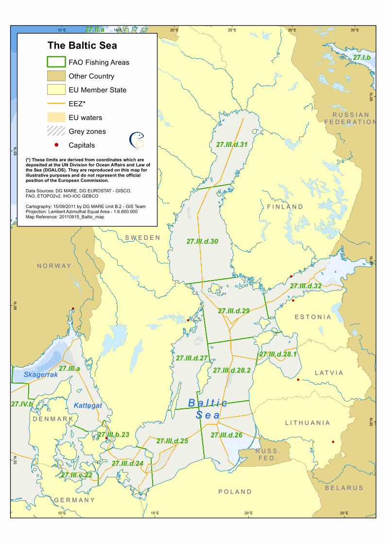
B a l t i cB a l t i cS e aS e a

KattegatKattegat

SkagerrakSkagerrak

27.III.d.2427.III.d.24

27.III.b.2327.III.b.23 27.III.d.2627.III.d.26

27.IV.b27.IV.b

27.II.a27.II.a

27.I.b27.I.b

27.III.c.2227.III.c.22

27.III.d.2727.III.d.2727.III.d.28.227.III.d.28.2

27.III.d.2927.III.d.29

27.III.d.28.127.III.d.28.1

27.III.d.3227.III.d.32

27.III.d.3027.III.d.30

27.III.d.3127.III.d.31

27.III.a27.III.a

27.III.d.2527.III.d.25

G E R M A N YG E R M A N Y

R U S S I A NR U S S I A NF E D E R A T I O NF E D E R A T I O N

F I N L A N DF I N L A N D

L A T V I AL A T V I A

N O R W A YN O R W A Y

E S T O N I AE S T O N I A

B E L A R U SB E L A R U S

S W E D E NS W E D E N

L I T H U A N I AL I T H U A N I AD E N M A R KD E N M A R K

P O L A N DP O L A N D

R U S S .R U S S .F E D .F E D .

35°E30°E

25°E

25°E

20°E

20°E

15°E

15°E

10°E

10°E

65°N

65°N

60°N

60°N

55°N

55°N

(*) These limits are derived from coordinates which are deposited at the UN Division for Ocean Affairs and Law ofthe Sea (DOALOS). They are reproduced on this map for illustrative purposes and do not represent the official position of the European Commission. Data Sources: DG MARE, DG EUROSTAT - GISCO, FAO, ETOPO2v2, IHO-IOC GEBCO Cartography: 15/09/2011 by DG MARE Unit B.2 - GIS TeamProjection: Lambert Azimuthal Equal Area - 1:6.600.000Map Reference: 20110915_Baltic_map

The Baltic SeaFAO Fishing AreasOther CountryEU Member StateEEZ*EU watersGrey zones

!. Capitals