Embed Size (px)
Citation preview

ESA UNCLASSIFIED - For Official Use
Jolyon Martin, Sentinel Data Access Manager &
Sentinel-5P Operations Manager, ESA
Pierre Potin, Sentinel-1 Mission Manager, ESA
“Earth Observation Showcase – Emerging Applications
Powered by Innovative Technologies”
26th October 2017, Satellite Applications Catapult, Harwell
THE COPERNICUS PROGRAMME

ESA UNCLASSIFIED - For Official Use
Catapult Open
Services Component
What is Copernicus?
European response to global needs: • to manage the
environment, • to mitigate the
effects of climate change and
• to ensure civil security
Space Component
In-Situ Data

ESA UNCLASSIFIED - For Official Use
Catapult Open
What is Copernicus?

ESA UNCLASSIFIED - For Official Use
Catapult Open
Copernicus Users
Policymakers
Public AuthoritiesPrivate Persons
Large Institutional User OrganisationsStudents
Decision Makers
Space Enthusiasts
Value-Adding Companies
Scientists
Start-Up Companies

ESA UNCLASSIFIED - For Official Use
Catapult Open
Copernicus/GMES Facts & Figures
>100,000Number of self-registered users (Open Data Hub)
€ 0to pay for access to Sentinel data
€ 10 of public return for every € 1 spent by the European tax payer on Copernicus
6service domains covered 2014
start of Copernicus operational phase
>€ 7 Binvested by ESA and EU till this day 20
new satellites & instruments specifically developed for the operational needs of Copernicus
83,000jobs generated by Copernicus by 2030
ESA UNCLASSIFIED - For Official Use
Catapult Open
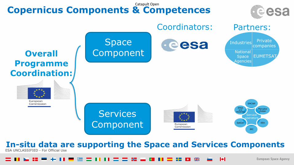
Copernicus Components & Competences
Services Component
Space ComponentOverall
ProgrammeCoordination:
Coordinators: Partners:
Service operators
EMCWF
Mercator Océan
EEA
JRC
SatCen
EMSA and
FRONTEX
Industries Private companies
National Space
Agencies
EUMETSAT
In-situ data are supporting the Space and Services Components

ESA UNCLASSIFIED - For Official Use
Catapult Open
Copernicus Services Component
Services Component
Marine
Land
Atmosphere
Emergency Management
Security
Climate Change
ESA UNCLASSIFIED - For Official Use
Catapult Open
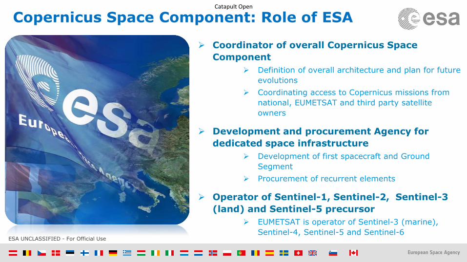
Copernicus Space Component: Role of ESA
➢ Coordinator of overall Copernicus Space
Component
➢ Definition of overall architecture and plan for future
evolutions
➢ Coordinating access to Copernicus missions from
national, EUMETSAT and third party satellite
owners
➢ Development and procurement Agency for
dedicated space infrastructure
➢ Development of first spacecraft and Ground
Segment
➢ Procurement of recurrent elements
➢ Operator of Sentinel-1, Sentinel-2, Sentinel-3
(land) and Sentinel-5 precursor
➢ EUMETSAT is operator of Sentinel-3 (marine),
Sentinel-4, Sentinel-5 and Sentinel-6

ESA UNCLASSIFIED - For Official Use
Catapult Open
Copernicus Space Component: the dedicated Sentinels …
S1A/B: Radar Mission 3 Apr 2014/25 Apr 2016
S2A/B: High Resolution Optical Mission 23 June 2015/7 March 2017
S3A/B: Medium Resolution Imaging and Altimetry Mission 16 Feb 2016/2018
S4A/B: Geostationary Atmospheric Chemistry Mission 2021/2027
S5P: Low Earth Orbit Atmospheric Chemistry Mission 13 Oct 2017
S5A/B/C: Low Earth Orbit Atmospheric Chemistry Mission 2021/2027
S6A/B: Altimetry Mission 2020/2025

ESA UNCLASSIFIED - For Official Use
Catapult Open
… with a long-term operational perspective (with Next Gen)
S-1 A/B/C/D
S-1 Next Generation
S-2 A/B/C/D
S-2 Next Generation
S-3 A/B/C/D
S-3 Next Generation
S-4 A/B (on MTG)
S-5 Precursor
S-5 A/B/C (on MetOp-SG)
S-6 A/B
Access to Contributing Missions

ESA UNCLASSIFIED - For Official Use
Catapult Open
Copernicus Contributing Missions
Copernicus Contributing
Missions
Atmospheric missions
PROBA-V
SPOT (VGT)
MetOp Meteosat 2nd Generation
Cryosat
Jason
DMC
Deimos-2
Pléiades
RapidEye
SPOT (HRS)
COSMO-Skymed
Radarsat
TerraSAR–X
Tandem-X
… and many more!

ESA UNCLASSIFIED - For Official Use
Catapult Open
Advantages of Sentinel Satellites
Most comprehensive EO system in the
world
Free Sentinel data
Long-term observations
Complementary to Contributing
Missions
Fully operational
system
ESA UNCLASSIFIED - For Official Use
Catapult Open
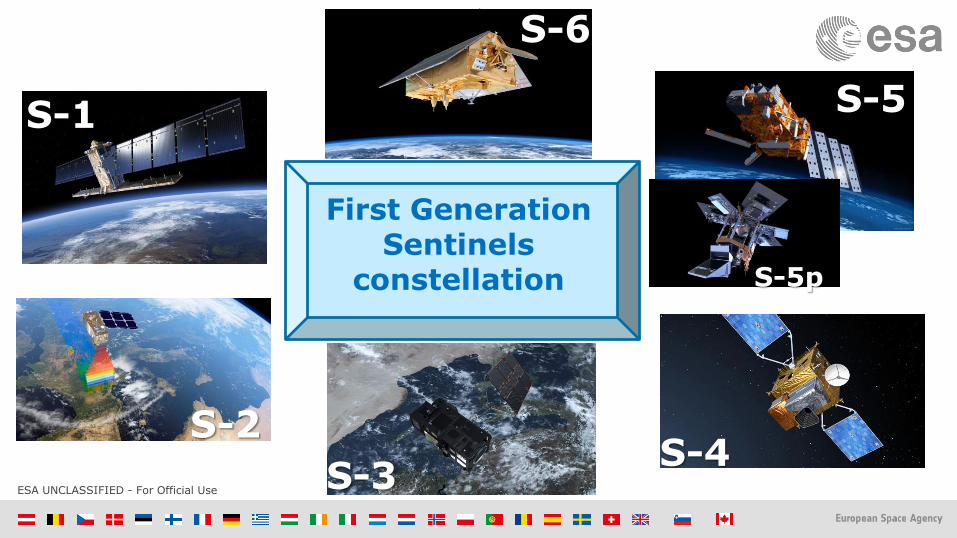
S-1
S-2
S-3S-4
S-5
S-6
S-5p
First Generation Sentinels
constellation

ESA UNCLASSIFIED - For Official Use
Catapult Open
Sentinel-1 C-band SAR mission
Mission profile:
C-Band SAR at 5.4 GHz, multi-polarisation
Sun synchronous orbit at 693 km mean altitude
250 km swath width (Interferometric Wide-swath mode)
6 days repeat cycle at Equator with 2 satellites
7 years design life time, consumables for 12 years
4 nominal mutually exclusive operation modes
Mission objectives:➢ Ice and marine, land monitoring➢ Support to crisis management

ESA UNCLASSIFIED - For Official Use
Catapult Open
Terrain Observation by Progressive Scans
(TOPS)
Image Acquisition in Interferometric Wide Swath mode (IW)

ESA UNCLASSIFIED - For Official Use
Catapult Open
Sentinel-1 observation scenarioMain thematic domains & components
Maritime surveillance
Sea state
Sea-ice, icebergs, lake-ice
European coverage
Ice sheets, glaciers, permafrost, snow, etc
Ground deformation: Tectonic, volcanoes, landslides, subsidence… (InSAR applications)
Global land mapping
Security
Land cover: agriculture, forestry,
hydrology, etc.
Emergency Calibration/validatio
n
PR actions (infrequent)

ESA UNCLASSIFIED - For Official Use
Catapult Open
ESA UNCLASSIFIED - For Official Use
Catapult Open
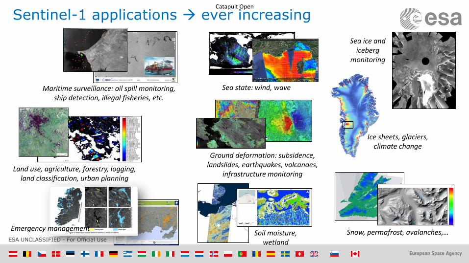
Snow, permafrost, avalanches,…
Ground deformation: subsidence, landslides, earthquakes, volcanoes,
infrastructure monitoring
Maritime surveillance: oil spill monitoring, ship detection, illegal fisheries, etc.
Ice sheets, glaciers, climate change
Soil moisture, wetland
Sea ice and iceberg
monitoring
Sea state: wind, wave
Land use, agriculture, forestry, logging, land classification, urban planning
Sentinel-1 applications ever increasing
Emergency management

ESA UNCLASSIFIED - For Official Use
Catapult OpenRegular Ice Charts based on Sentinel-1 imagery routinely generated by CMEMS

ESA UNCLASSIFIED - For Official Use
Catapult OpenSea Ice Concentration Charts based on Sentinel-1 imagery routinely generated by CMEMS
High resolution sea ice concentration charts
(early September 2017)
Greenland
Svalbard
Generated using E.U. Copernicus Marine Service Information
The Copernicus Marine Environment Monitoring Service provides daily high resolution sea ice concentrations derived from Sentinel-1 mission data.

ESA UNCLASSIFIED - For Official Use
Catapult OpenRegular Iceberg detection maps based on Sentinel-1 imagery routinely generated by CMEMS
Daily maps of position of icebergs
ESA UNCLASSIFIED - For Official Use
Catapult Open
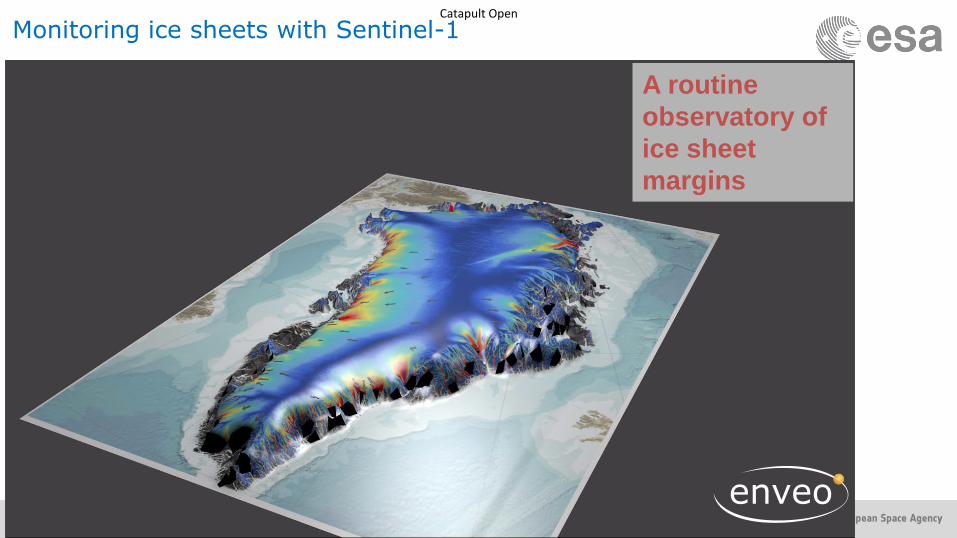
Monitoring ice sheets with Sentinel-1
A routine
observatory of
ice sheet
margins

ESA UNCLASSIFIED - For Official Use
Catapult Open
Sentinel-1A30/09/2015
World Bank project developed within the West Africa Regional Fisheries Project (WARFP) for IUU (Illegal, Unlicensed and Unreported) fisheries detection
Detection correlated with cooperative transponder data (green) and non-cooperative data (red) usually associated with IUU activities (vessels engaged in fishing in restricted areas/EEZs without authorisation).
Fisheries Surveillance for WARFP

ESA UNCLASSIFIED - For Official Use
Catapult Open
Sentinel-1 is operationally used by EMSA since June 2016 for the CleanSeaNet service
Sentinel-1A TOPS EW HH/HVacquired on 25 April 2014
CleanSeaNet: the European satellite-based oil pollution and vessel detection monitoring system
Operated by the European Maritime and Safety Agency (EMSA)
Sentinel-1 currently represents 85 % of satellite imagery used for CleanSeaNet

ESA UNCLASSIFIED - For Official Use
Catapult OpenMultiple flowlines spills Identified East of the USAN FPSO(Floating Production Storage and Offloading) vessels, Nigeria, Gulf of Guinea
Sentinel-1A imagery, 18.01.2016

ESA UNCLASSIFIED - For Official Use
Catapult Open
Offshore Oil and Gas Monitoring
Up to 50 Sentinel-1 images
are being used each month to
track upstream icebergs from
several offshore platforms
Iceberg and ship detections
are correlated with satellite
AIS
Ice edge information also
integrated into the product

ESA UNCLASSIFIED - For Official Use
Catapult Open
Combined sigma_0 and coherence (both VV) for a part of Flevoland, using both S1A and S1BSep 2016 -> Feb 2017(courtesy: Guido Lemoine, JRC)
- Coherence varies spectacularly due to soil cultivation in the autumn period
- Towards end of Nov, the change in coherence slows down, and most fields show high coherence because they are essentially stable bare soil (bright video frames).
- Over Jan and Feb, coherence blurs due to snow and frost/thaw affects, but the coherence patterns remain stable until late Feb

ESA UNCLASSIFIED - For Official Use
Catapult OpenFlood delineation map based on Sentinel-1 dataCopernicus Emergency Management Service Flood in Cumbria, UK, Dec 2015
© Copernicus Service information (2015)/CEMS

ESA UNCLASSIFIED - For Official Use
Catapult Open
Ground displacement of the San Francisco Bay Area measured by Sentinel-1
Contains modified Copernicus Sentinel data (2015–16) / ESA SEOM INSARAP study / PPO.labs / Norut / NGU
Hot spots are clearly observed, including the Hayward fault running north–south of the central-right side of the image. Subsidence of the newly reclaimed land in the San Rafael Bay on the left is also visible, while an uplift of land is visible in the lower right, possibly a result of a recovering groundwater level after a four-year long drought that ended in autumn 2015.
Example of Land Deformation monitoring

ESA UNCLASSIFIED - For Official Use
Catapult Open
San Francisco Millennium Tower sinking
Contains modified Copernicus Sentinel data (2015–16) / ESA SEOM INSARAP study / PPO.labs / Norut / NGU
Data from the Sentinel-1 satellites acquired between 22 Feb 2015 and 20 Sep 2016 show that Millennium Tower in San Francisco is sinking by about 40 mm a year in the ‘line of sight’ – the direction that the satellite is ‘looking’ at the building.
This translates into a vertical subsidence of almost 50 mm a year, assuming no tilting.
The coloured dots represent targets observed by the radar. The colour scale ranges from 40 mm a year away from radar (red) to 40 mm a year towards radar (blue). Green represents stable targets.

ESA UNCLASSIFIED - For Official Use
Catapult Open
Sentinel-2 Superspectral imaging mission
Mission profile
Multispectral instrument with 13 spectral bands (VIS, NIR & SWIR)
Sun synchronous orbit at 786 km mean altitude
290 km swath width
5 days repeat cycle at Equator (cloud free) with 2 satellites
7 years design life time, consumables for 12 years
10, 20 and 60 m spatial resolution
Mission objectives:➢ Generic land cover maps
➢ Risk mapping and disaster relief
ESA UNCLASSIFIED - For Official Use
Catapult Open
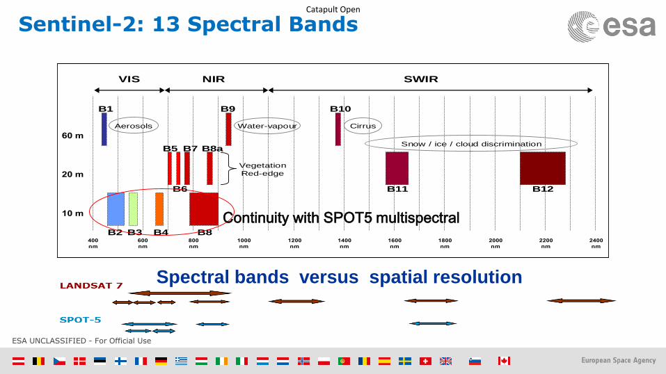
Sentinel-2: 13 Spectral Bands
Spectral bands versus spatial resolution
400
nm
600
nm
800
nm
1000
nm
1200
nm
1400
nm
1600
nm
1800
nm
2000
nm
2200
nm
2400
nm
10 m
20 m
60 m
VNIR
SWIR
Visible
VIS NIR SWIR
B1
B2 B3 B4 B8
B5
B6
B7 B8a
B9 B10
B11 B12
Vegetation
Red-edge
Aerosols Water-vapour Cirrus
Snow / ice / cloud discrimination
Continuity with SPOT5 multispectral

ESA UNCLASSIFIED - For Official Use
Catapult Open
Ever increasing range of Applications
Regional to Urban Applications
Geology & Geomorphology
Emergency
management
Global Land use
& land coverCoastal zones/bathymetry
Glaciers & Ice
European Land cover, human impact, high resolution
layers
Forests & Carbon, Vegetation monitoring
Water quality, Wetlands
Agriculture, Fluorescence & biophysical parameters

ESA UNCLASSIFIED - For Official Use
Catapult Open
Copernicus Land Core Services
Sources: EEA; GAF AG
– Land cover/ use
characteristics
– Forest: Tree Cover
Density [%]
– European
Riparian
Zones

ESA UNCLASSIFIED - For Official Use
Catapult Open
Developing a sustainable urban environment
Sentinel 2


![Section 6-CCD.ppt [Λειτουργία συμβατότητας]tsiatouhas/CCD/Section_6-2p.pdf · Tmin,org tc q tp_add tp_abs tp_log ... abb ced e L1 L1S2a S2b L2 S1a S1b Clock](https://img.pdfslide.net/doc/110x75/5bf9fa7b09d3f2941b8b91f5/section-6-ccdppt-tsiatouhasccdsection6-2ppdf.jpg)