Embed Size (px)
Citation preview
The Earth and Its Peoples
3rd edition
Chapter 20
Southwest Asia and the Indian Ocean,
1500-1750
Cover Slide
Copyright © Houghton Mifflin Company. All rights reserved.

Akbar on elephantThis miniature from the Akbarnama of Abul Fazl (ca. 1590) by Basawan and Chatai, on the life of Akbar (r. 1556-1605), shows Akbar "taming a savage elephant outside the Red Fort of Agra." Mughal miniature painters were adept at depicting unconventional action scenes such as this, where elephants are breaking a bridge of boats. Because the flow of rivers in India and the Middle East varied greatly from dry season to wet season, boat bridges were much more common than permanent constructions. (Victoria & Albert Museum/The Bridgeman Art Library International)
Akbar on elephant
Copyright © Houghton Mifflin Company. All rights reserved.
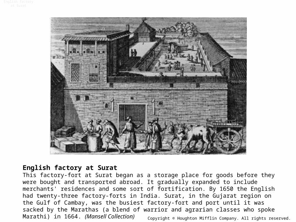
English factory at SuratThis factory-fort at Surat began as a storage place for goods before they were bought and transported abroad. It gradually expanded to include merchants' residences and some sort of fortification. By 1650 the English had twenty-three factory-forts in India. Surat, in the Gujarat region on the Gulf of Cambay, was the busiest factory-fort and port until it was sacked by the Marathas (a blend of warrior and agrarian classes who spoke Marathi) in 1664. (Mansell Collection)
English factory at Surat
Copyright © Houghton Mifflin Company. All rights reserved.
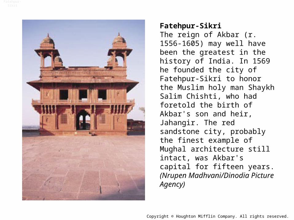
Fatehpur-SikriThe reign of Akbar (r. 1556-1605) may well have been the greatest in the history of India. In 1569 he founded the city of Fatehpur-Sikri to honor the Muslim holy man Shaykh Salim Chishti, who had foretold the birth of Akbar's son and heir, Jahangir. The red sandstone city, probably the finest example of Mughal architecture still intact, was Akbar's capital for fifteen years. (Nrupen Madhvani/Dinodia Picture Agency)
Fatehpur-Sikri
Copyright © Houghton Mifflin Company. All rights reserved.
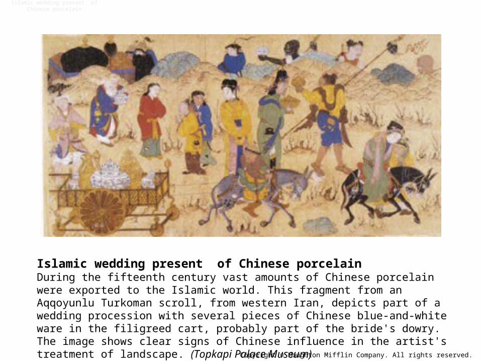
Islamic wedding present of Chinese porcelainDuring the fifteenth century vast amounts of Chinese porcelain were exported to the Islamic world. This fragment from an Aqqoyunlu Turkoman scroll, from western Iran, depicts part of a wedding procession with several pieces of Chinese blue-and-white ware in the filigreed cart, probably part of the bride's dowry. The image shows clear signs of Chinese influence in the artist's treatment of landscape. (Topkapi Palace Museum)
Islamic wedding present of Chinese porcelain
Copyright © Houghton Mifflin Company. All rights reserved.
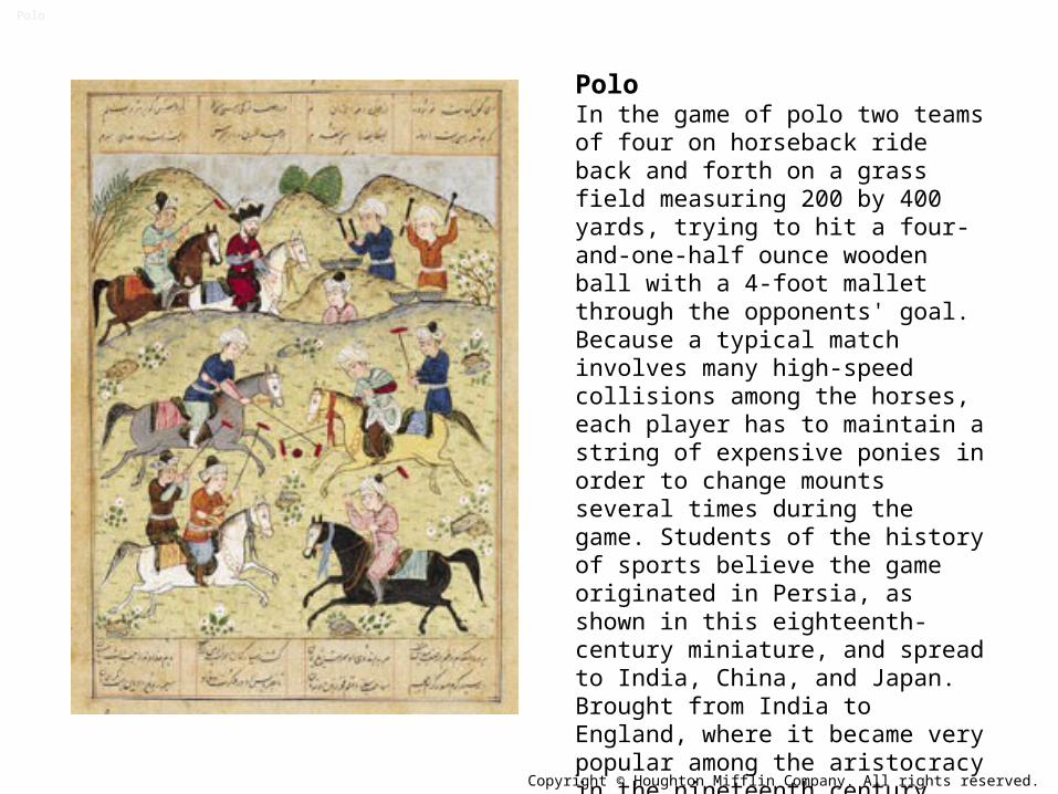
PoloIn the game of polo two teams of four on horseback ride back and forth on a grass field measuring 200 by 400 yards, trying to hit a four-and-one-half ounce wooden ball with a 4-foot mallet through the opponents' goal. Because a typical match involves many high-speed collisions among the horses, each player has to maintain a string of expensive ponies in order to change mounts several times during the game. Students of the history of sports believe the game originated in Persia, as shown in this eighteenth-century miniature, and spread to India, China, and Japan. Brought from India to England, where it became very popular among the aristocracy in the nineteenth century, polo is a fine example of cross-cultural influences. (Private Collection)
Polo
Copyright © Houghton Mifflin Company. All rights reserved.

Portuguese fort guarding Musqat harborPortuguese power in East Africa suffered severe blows when the Arabs of Oman, in southeastern Arabia, captured their south Arabian stronghold at Musqat (1650) and went on to create a maritime empire of their own, working in greater cooperation with the African populations. Musqat in Oman and Aden in Yemen, the best harbors in southern Arabia, were always targets for imperial navies trying to establish dominance in the Indian Ocean. Musqat's harbor is small and circular with one narrow entrance overlooked by the fortress. The palace of the sultan of Oman is still located at the opposite end of the harbor. (Robert Harding Picture Library)
Portuguese fort guarding Musqat harbor
Copyright © Houghton Mifflin Company. All rights reserved.
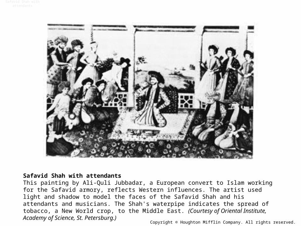
Safavid Shah with attendantsThis painting by Ali-Quli Jubbadar, a European convert to Islam working for the Safavid armory, reflects Western influences. The artist used light and shadow to model the faces of the Safavid Shah and his attendants and musicians. The Shah's waterpipe indicates the spread of tobacco, a New World crop, to the Middle East. (Courtesy of Oriental Institute, Academy of Science, St. Petersburg.)
Safavid Shah with attendants
Copyright © Houghton Mifflin Company. All rights reserved.
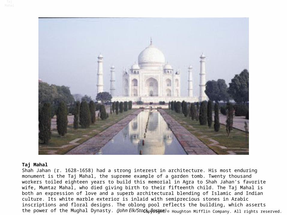
Taj MahalShah Jahan (r. 1628-1658) had a strong interest in architecture. His most enduring monument is the Taj Mahal, the supreme example of a garden tomb. Twenty thousand workers toiled eighteen years to build this memorial in Agra to Shah Jahan's favorite wife, Mumtaz Mahal, who died giving birth to their fifteenth child. The Taj Mahal is both an expression of love and a superb architectural blending of Islamic and Indian culture. Its white marble exterior is inlaid with semiprecious stones in Arabic inscriptions and floral designs. The oblong pool reflects the building, which asserts the power of the Mughal Dynasty. (John Elk/Stock, Boston)
Taj Mahal
Copyright © Houghton Mifflin Company. All rights reserved.

Map: European Colonization in Indian Ocean to 1750
European Colonization in Indian Ocean to 1750Since Portuguese explorers were the first Europeans to reach India by rounding Africa, Portugal gained a strong foothold in both areas. Rival Spain was barred from colonizing the region by the Treaty of Tordesillas in 1494, which limited Spanish efforts to lands west of a line drawn through the mid-Atlantic Ocean. The line carried around the globe provided justification of Spanish colonization in the Philippines. French, British, and Dutch colonies date from after 1600 when joint stock companies provided a new stimulus for overseas commerce. (Copyright (c) Houghton Mifflin Company. All Rights Reserved.)
Copyright © Houghton Mifflin Company. All rights reserved.
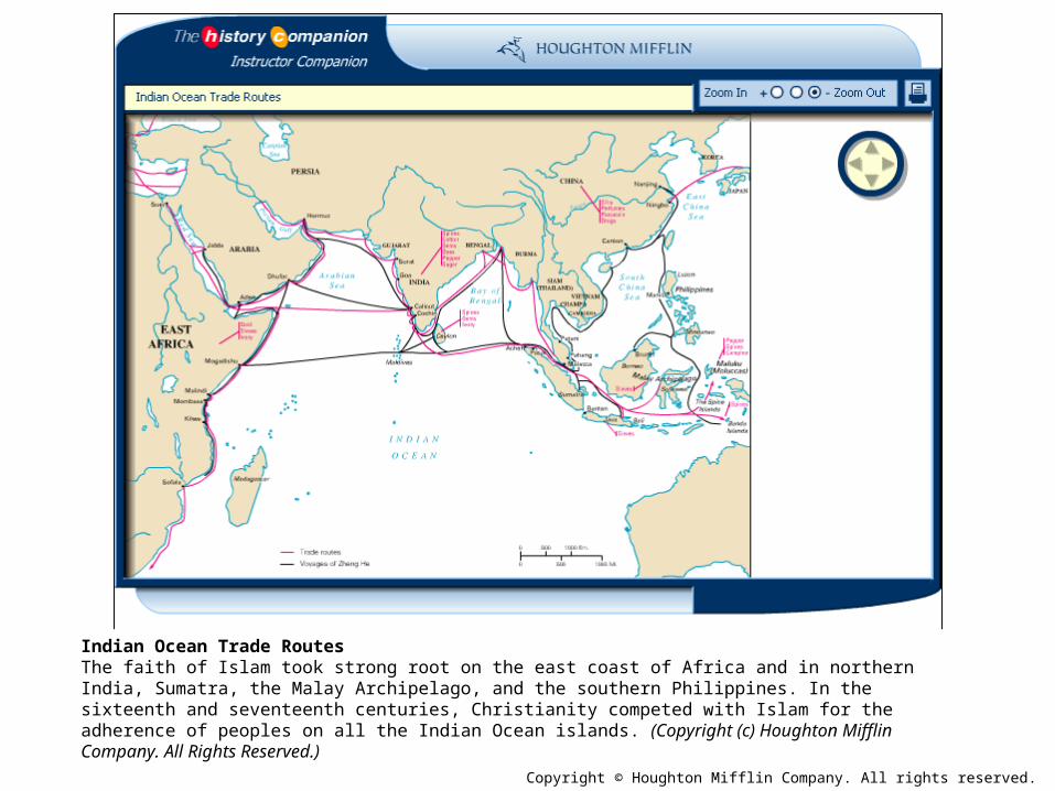
Map: Indian Ocean Trade Routes
Indian Ocean Trade RoutesThe faith of Islam took strong root on the east coast of Africa and in northern India, Sumatra, the Malay Archipelago, and the southern Philippines. In the sixteenth and seventeenth centuries, Christianity competed with Islam for the adherence of peoples on all the Indian Ocean islands. (Copyright (c) Houghton Mifflin Company. All Rights Reserved.)
Copyright © Houghton Mifflin Company. All rights reserved.

Map: Muslim Empires in the Sixteenth and Seventeenth Centuries
Muslim Empires in the Sixteenth and Seventeenth CenturiesIran, a Shi'ite state flanked by Sunni Ottomans on the west and Sunni Mughals on the east, had the least exposure to European influences. Ottoman expansion across the southern Mediterranean Sea intensified European fears of Islam. The areas of strongest Mughal control dictated that Islam's spread into southeast Asia would be heavily influenced by merchants and religious figures from Gujarat instead of from eastern India. (Copyright (c) Houghton Mifflin Company. All Rights Reserved.)
Copyright © Houghton Mifflin Company. All rights reserved.

Map: The Ottoman Empire at Its Height, 1566
The Ottoman Empire at Its Height, 1566The Ottomans, like their great rivals the Habsburgs, rose to rule a vast dynastic empire encompassing many different peoples and ethnic groups. The army and the bureaucracy served to unite the disparate territories into a single state. (Copyright (c) Houghton Mifflin Company. All Rights Reserved.)
Copyright © Houghton Mifflin Company. All rights reserved.

Map: The Safavid Empire
The Safavid EmpireIn the late sixteenth century, the power of the Safavid kingdom of Persia rested on its strong military force, its Shi'ite Muslim faith, and its extraordinarily rich trade in rugs and pottery. Many of the cities on the map, such as Tabriz, Qum, and Shiraz, were great rug-weaving centers. (Copyright (c) Houghton Mifflin Company. All Rights Reserved.)
Copyright © Houghton Mifflin Company. All rights reserved.