Embed Size (px)
Citation preview

TheEastRidingCoastline:Past,PresentandFuture
Research·April2017
CITATIONS
0
READS
53
3authors:
Someoftheauthorsofthispublicationarealsoworkingontheserelatedprojects:
ClimatechangeandEuropeanaquaticResources(CERES)Viewproject
UKNationalEcosystemAssessmentFollowOn:CoastalZonesViewproject
SueBoyes
UniversityofHull
19PUBLICATIONS228CITATIONS
SEEPROFILE
SteveBarnard
UniversityofHull
39PUBLICATIONS74CITATIONS
SEEPROFILE
MichaelElliott
UniversityofHull
282PUBLICATIONS9,997CITATIONS
SEEPROFILE
AllcontentfollowingthispagewasuploadedbySueBoyeson26April2017.
Theuserhasrequestedenhancementofthedownloadedfile.Allin-textreferencesunderlinedinblueareaddedtotheoriginaldocument
andarelinkedtopublicationsonResearchGate,lettingyouaccessandreadthemimmediately.
Institute of Estuarine and Coastal Studies (IECS) The University of Hull Cottingham Road Hull HU6 7RX
Tel: +44 (0)1482 466771 Fax: +44 (0)1482 466772 Email: [email protected]
January 2016www.hull.ac.uk/iecs
The East Riding Coastline:Past, Present and Future
www.hull.ac.uk/iecs
Institute of Estuarine and Coastal Studies
Chapter 2
Coastal processes
Coastal processes on the East Riding coastline 11
Geology 11
Beaches 12
Waves, currents and tides 14
Mechanics of erosion 17
Sediment budget 19
Erosion rates 20
Impact of dredging on erosion rates 26
Sea level rise and climate change 26
www.hull.ac.uk | II
The East Riding Coastline: Past, Present and Future
Contents
Chapter 1
Development of the East Riding coastline
Ice age 1
Lost villages 1
Current day 2 Bempton to Bridlington 4
Holderness Coast 5
Spurn 6
1
Foreword V
Preface VI
Frequently asked questions VIII
11Chapter 3
Coastal monitoring
Why the coastline is monitored 29
History of monitoring 30
Current techniques 32
Analysis of data 35
Data publication 35
29Chapter 4
Defending the East Riding coastline
The history of coastal engineering 37
Defence options 38
Defended areas along the East Riding coastline 42 Bridlington 42
Barmston 44
Hornsea 44
Mappleton 44
Withernsea 44
Easington 44
Spurn 45
Undefended coastline 45
Links between defended coastlines and increased downstream erosion? 46
Defend the entire coastline? 47
Funding and maintenance arrangements 47
Socio-economic implications 50
37 37
I | www.hull.ac.uk
The East Riding Coastline: Past, Present and Future
III | www.hull.ac.uk www.hull.ac.uk | IV
The East Riding Coastline: Past, Present and Future The East Riding Coastline: Past, Present and Future
Chapter 5
Coastal management, policy and legislation
European legislation 53
EU Integrated Coastal Zone Management (ICZM)
Recommendation 53
Marine Strategy Framework Directive (MSFD) 54
Habitats and Species Directive 55
Birds Directive 56
Water Framework Directive 58
Flood Risk Management Directive 58
Bathing Water Directive 59
Maritime Spatial Planning Directive 59
Environmental Impact Assessment Directive (EIA) 60
Strategic Environmental Assessment Directive (SEA) 60
UK legislation 62
Coast Protection Act 1949 62
Flood and Water Management Act 2010 62
Marine and Coastal Access Act 2009 63
Conservation Legislation 63
Marine Policy Statement (MPS) 67
Planning Policy Statements (PPS) 67
Non-statutory policies and plans 68
Shoreline Management Plans (SMPs) 68
Integrated Coastal Zone Management (ICZM)
plans 69
53 71Chapter 6
Coastal management practitioners
Who is responsible for coastal management? 71
Government bodies 71
Non-departmental public bodies 74
Non-statutory stakeholders 76
79Chapter 7
Coastal change management options
Introduction 79
Legal aspects 79
Legislation 79
Local planning controls 80
Policy guidance and best practice 80
National Planning Policy Framework (NPPF) 80
PPS25 and supplement 81
Adapting to coastal change: Developing a
policy framework 82
Community Adaptation Planning and
Engagement (CAPE) 82
Cliff instability and erosion management in
Great Britain 83
National coastal change pathfinder scheme 83
East Riding coastal change pathfinder / East
Riding coastal change fund 83
References 86
This report provides an overview of the current knowledge on the development and management practices along the East Riding coastline. This coastal resource will be valuable for many users, especially teachers and students and the general public. It meets the needs of the national curriculum with information for the Key Stage 2 primary education geography syllabus (pupils aged 7-11), and students at Key Stage 3 (pupils aged 11 to 14) to understand key processes in physical geography. The East Riding coastline has long been used as an excellent educational case study for understanding geological timescales and plate tectonics; rocks, weathering and soils; weather and climate, including the changes from the Ice Age to the present, and glaciation, erosion, hydrology and coasts. It also provides an important review of current literature for GCSE studies and further and higher education. This coastal resource provides the general public with information on the local area and explains the decisions currently being taken by East Riding of Yorkshire Council (ERYC) regarding coastline protection and management.
Although ERYC staff have had an input to this document, all the discussions are based on peer-reviewed literature, grey literature and websites with its interpretation by the authors. Hence the Institute and the authors are responsible for the content of this report. We welcome feedback by all interested parties – the Institute can be contacted by telephone on +44 (0)1482 466771 and by email on [email protected].
This coastal resource was funded through the Defra Coastal Change Pathfinder project and the East Riding Coastal Change Pathfinder (ERCCP). The authors would like to acknowledge the input from various East Riding of Yorkshire Council staff in the preparation of this report especially Neil McLachlan, Jennifer Kippax, Jeremy Pickles, Richard Jackson and the rest of the Sustainable Development and Flood and Coastal Erosion Risk Management teams.
Please cite the coastal resource as: Boyes, S.J., Barnard, S. & Elliott, M. 2016. The East Riding Coastline: Past, Present and Future. Prepared for East Riding of Yorkshire Council (ERYC) by the Institute of Estuarine and Coastal Studies (IECS), University of Hull. Funded through the Defra Coastal Change Pathfinder project and the East Riding Coastal Change Pathfinder (ERCCP). Institute of Estuarine and Coastal Studies, University of Hull, Hull, HU6 7RX, UK.
Published January 2016 © University of Hull
V | www.hull.ac.uk
The East Riding Coastline: Past, Present and Future
www.hull.ac.uk | VI
The East Riding Coastline: Past, Present and Future
Foreword PrefaceThe Holderness coastline of the East Riding of Yorkshire is widely regarded as one of the fastest eroding coastlines in Europe and has been so since the last ice age. Despite this, it is the home to several towns and many villages and a thriving tourism and fishing industry. The area has long suffered from the social and economic costs of the erosion and many villages have disappeared into the North Sea in recorded history.
The University of Hull was founded in 1927 and is England’s 14th oldest university. It has, since its foundation, undertaken research and teaching in marine and estuarine fields with the pioneering sampling of the North Sea waters and teaching of marine biology by Sir Alistair Hardy FRS, the first Professor of Zoology. This ground-breaking work enabled Sir Alistair to determine the food of fishes and the relationship between the plankton food and the herring catches which sustained much of the east coast of the UK. Other notable staff of the University included Professor George de Boer and Professor John Pethick, both internationally renowned coastal geomorphologists, who first studied the Holderness and Humber coastlines.
Many parts of the University have expertise in the estuarine, coastal and marine fields, including ecology, geography, chemistry, governance, security, engineering, business, economics, planning and management. Because of this, the University’s researchers have been funded by local and national groups, regulatory bodies, industries and non-governmental organisations, as well as the European Commission. This in turn has enabled the teaching of marine and coastal features to many generations of students.
Since 1982, the University’s Institute of Estuarine and Coastal Studies (IECS) has undertaken teaching, research and consultancy related to the Humber and Yorkshire coast (the natural features and the social aspects). Over past decades the Institute has been carrying out similar activities worldwide, while still maintaining its local expertise.
The East Yorkshire coast and Humber Estuary, which is influenced by the dynamics of the adjacent coasts, are central to the social and economic well-being of the area in which the University is situated.
This booklet will provide a much needed summary of the fascinating and dynamic local coastline for decision-makers, elected officials and the public and has been produced by IECS in collaboration with East Riding of Yorkshire Council. Professor Calie PistoriusVice-ChancellorUniversity of Hull
In 1994, the Institute of Estuarine and Coastal Studies (IECS; see www.hull.ac.uk/iecs) at the University of Hull, under the former director Professor John Pethick, was commissioned by the former Humberside County Council to produce two documents entitled Humber Estuary and Coast and Humber Estuary and Coast – Management Issues. These documents were designed to provide the public, stakeholders and environmental managers with information regarding coastal processes and management issues occurring along the (primarily) Holderness coast. In the intervening years, the understanding of the coast and its problems has changed and considerable benefit was seen in updating these reports, bringing together relevant information and incorporating new initiatives which have been implemented to adapt to coastal erosion along the East Riding coastline during the past two decades.
As a consequence, IECS at the University of Hull, under the directorship of Professor Mike Elliott, received funding from the ERCCP second (and final) call period of the Small Grants Fund to update the 1994 publications with a new coastal resource entitled The East Riding Coastline: Past, Present and Future. The contents of this new resource underpin the Council’s own coastal change communications toolkit and complements the Pathfinder’s ethos of community engagement. The content also reinforces the wider work East Riding of Yorkshire Council (ERYC) carry out on the coastline in terms of Integrated Coastal Zone Management (ICZM) and disseminating information about coastal change, initiatives and adaptive management through the coastal forum.
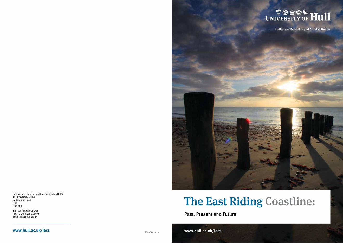
This coastal resource covers the East Riding coastline from Bempton in the north down to Spurn Point in the south, most of which is given the geographical name of Holderness (see map showing study area). The 85 km long coastline is characterised by a diverse range of landscapes and habitats, from the chalk headland at Flamborough with its important landscape and wildlife designations, through the Holderness plain (the section of coastline subject to some of the highest rates of erosion in Europe), to Spurn Point extending into the mouth of the Humber Estuary. Along the East Riding coastline lie the resort towns of Bridlington, Hornsea, and Withernsea, which are the main settlements. Numerous smaller communities also lie along its length.
www.hull.ac.uk | VIII
The East Riding Coastline: Past, Present and Future
VII | www.hull.ac.uk
The East Riding Coastline: Past, Present and Future
This report covers the historical and present development of the East Riding coastline, the use of that coastline for the local and visitor populations, and the means of managing such a diverse but changing environment. The report has the following 7 chapters:
Chapter 1 – Development of the East Riding Coastline describes the historic development of the East Riding coastline over the last 10,000 years, from the last ice age through to the present day landscape. It covers the settlements lost to erosion and describes the towns and villages along the present day coastline. Special attention is given to Spurn Point, its development and future.
Chapter 2 – Coastal Processes describes the physical characteristics and processes at work along the East Riding coastline, looking at the geology of the cliffs and the composition and influence of the beaches. It addresses the coastal processes of waves, tides, sediment budgets (longshore drift) and the types and mechanics of erosion (including marine and sub-aerial erosion processes and types of cliff failure) which, together, influence the rates of erosion along the coast. Erosion rates (past and present) are detailed, as are the implications of climate change, sea level rise and human activities (e.g. offshore dredging) regarding these rates.
Chapter 3 – Coastal Monitoring addresses how for more than 150 years, this coastline has attracted scientists and engineers to study its geology and rapid coastal erosion. A common practice to all the studies has been to measure and quantify the rates of erosion and predict future change. Over the years this has become more sophisticated with the use of satellite technology and computer modelling. This chapter looks at how the coastline is monitored by ERYC, how erosion rates have been calculated over time and how more sophisticated techniques have led to greater accuracy in the monitoring data.
Chapter 4 – Defending the East Riding Coastline looks at the history of coastal engineering along the East Riding coastline, addressing why some areas are selected for protection over others and the types of defence methods used (hard vs. soft options). It addresses the associated problems of defending eroding coastlines and discusses the funding and maintenance options and socio-economic implications of coastal protection works.
Chapter 5 – Coastal Management, Policy and Legislation addresses policy and legislation at the European, national and local scales, together with relevant policies and strategies that influence the management of the East Riding coastline. It provides an overview of selected EU law, important national legislation and planning, policy and non-statutory documents and plans guiding the management of the coast, including Shoreline Management Plans (SMPs) and ICZM plans.
Chapter 6 – Coastal Management Practitioners provides an overview of the roles and responsibilities of some of the key government bodies and local authorities with powers and duties relating to marine environmental management, coastal and flood defence, fisheries and conservation. It also mentions some of the other non-statutory stakeholders along the coast with an interest in management decisions and how they are affected by these factors.
Chapter 7 – Coastal Change Management Options discusses some of the alternative solutions being offered to local communities when defending the eroding coast is not a viable option. The national and local policy frameworks are discussed, together with the work undertaken by East Riding of Yorkshire Council (ERYC) to provide a suite of adaptive measures to support coastal communities through the East Riding Coastal Change Pathfinder (ERCCP) project of 2010-2012.
It is hoped that this report will also answer many of the questions regularly asked to both the Council and the Institute on coastal erosion and management issues. Please look at the frequently asked questions and the chapters which help to answer these:
• Why is the East Riding coastline eroding? – see Chapters 1 and 2
• Where does the eroded sediment from the East Riding coastline go? – see Chapter 2
• Have the local rates of coastal erosion increased in recent years? If so, why? – see Chapter 2
• At what point will coastal erosion slow down/stop due to changes in local geology? – see Chapter 2
• What is the average rate of erosion along the East Riding coastline? – see Chapter 2
• Does offshore dredging have any impact upon coastal erosion rates? – see Chapter 2
• How does East Riding of Yorkshire Council monitor rates of erosion? – see Chapter 3
• Why is the coastline monitored and who is responsible for carrying it out? – see Chapter 3
• Who decides which areas can benefit from engineered coastal defences? – see Chapters 4, 5 and 6
• Are there any plans to defend the entire East Riding coastline? – see Chapter 4
• Are there any plans to extend the engineered coastal defences which protect certain towns, villages, industries and roads? – see Chapter 4
• Can homeowners build their own coastal defences to protect their property/land? – see Chapter 4
• What is the cost of engineered coastal defences? – see Chapter 4
• Should the erosion of the East Riding coastline be reduced and if so, how? – see Chapter 4
• Which sections of the East Riding coastline benefit from engineered coastal defences? – see Chapter 4
• Who is responsible for building and maintaining coastal defences in the East Riding? – see Chapter 4
• Does the rate of coastal erosion increase to the south of engineered coastal defences? – see Chapter 4
• What are the economic, environmental and social impacts (positive and negative) of today’s coastal management approaches in the East Riding? – see Chapters 5, 6 and 7
• Which sections of the East Riding coastline benefit from engineered coastal defences? – see Chapter 5
• Who is responsible for building and maintaining coastal defences in the East Riding? – see Chapter 6
• Will East Riding of Yorkshire Council help me to move on if my property becomes at risk from coastal erosion? – see Chapter 7
• Does East Riding of Yorkshire Council have a legal duty to act when a property becomes at risk from coastal erosion? – see Chapter 7
• What is rollback? – see Chapter 7
Frequently asked questions
VIII | www.hull.ac.uk
Danes Dyke
The East Riding Coastline: Past, Present and Future
www.hull.ac.uk | 1
The East Riding Coastline: Past, Present and Future
Development of the East Riding coastline
Chapter 1
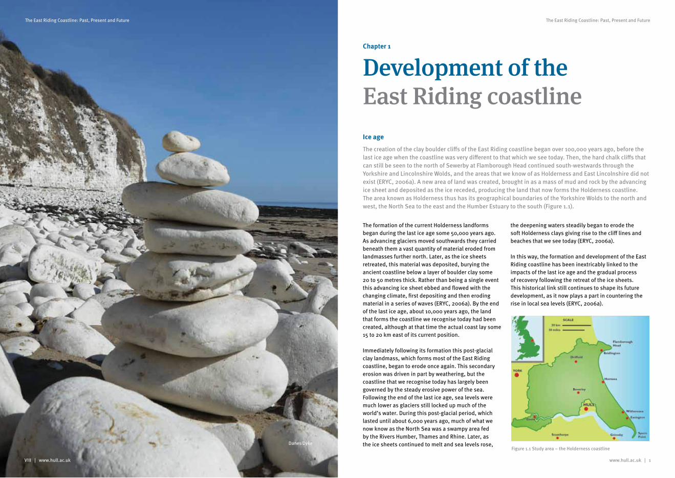
Figure 1.1 Study area – the Holderness coastline
Ice age
The creation of the clay boulder cliffs of the East Riding coastline began over 100,000 years ago, before the last ice age when the coastline was very different to that which we see today. Then, the hard chalk cliffs that can still be seen to the north of Sewerby at Flamborough Head continued south-westwards through the Yorkshire and Lincolnshire Wolds, and the areas that we know of as Holderness and East Lincolnshire did not exist (ERYC, 2006a). A new area of land was created, brought in as a mass of mud and rock by the advancing ice sheet and deposited as the ice receded, producing the land that now forms the Holderness coastline. The area known as Holderness thus has its geographical boundaries of the Yorkshire Wolds to the north and west, the North Sea to the east and the Humber Estuary to the south (Figure 1.1).
The formation of the current Holderness landforms began during the last ice age some 50,000 years ago. As advancing glaciers moved southwards they carried beneath them a vast quantity of material eroded from landmasses further north. Later, as the ice sheets retreated, this material was deposited, burying the ancient coastline below a layer of boulder clay some 20 to 50 metres thick. Rather than being a single event this advancing ice sheet ebbed and flowed with the changing climate, first depositing and then eroding material in a series of waves (ERYC, 2006a). By the end of the last ice age, about 10,000 years ago, the land that forms the coastline we recognise today had been created, although at that time the actual coast lay some 15 to 20 km east of its current position.
Immediately following its formation this post-glacial clay landmass, which forms most of the East Riding coastline, began to erode once again. This secondary erosion was driven in part by weathering, but the coastline that we recognise today has largely been governed by the steady erosive power of the sea. Following the end of the last ice age, sea levels were much lower as glaciers still locked up much of the world’s water. During this post-glacial period, which lasted until about 6,000 years ago, much of what we now know as the North Sea was a swampy area fed by the Rivers Humber, Thames and Rhine. Later, as the ice sheets continued to melt and sea levels rose,
the deepening waters steadily began to erode the soft Holderness clays giving rise to the cliff lines and beaches that we see today (ERYC, 2006a).
In this way, the formation and development of the East Riding coastline has been inextricably linked to the impacts of the last ice age and the gradual process of recovery following the retreat of the ice sheets. This historical link still continues to shape its future development, as it now plays a part in countering the rise in local sea levels (ERYC, 2006a).
2 | www.hull.ac.uk
The East Riding Coastline: Past, Present and Future
www.hull.ac.uk | 3
The East Riding Coastline: Past, Present and Future
Lost Villages
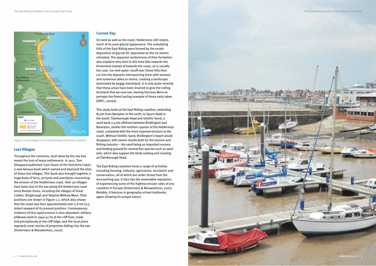
Throughout the centuries, land taken by the sea has meant the loss of many settlements. In 1912, Tom Sheppard published ‘Lost Towns of the Yorkshire Coast’, a now famous book which named and depicted the sites of these lost villages. This book also brought together a huge body of facts, pictures and anecdotes concerning the erosion of the Holderness coast. Over 30 villages have been lost to the sea along the Holderness coast since Roman times, including the villages of Great Colden, Ringbrough and Skipsea Withow Mere. Their positions are shown in Figure 1.2, which also shows that the coast was then approximately over 5.6 km (3.5 miles) seaward of its present position. Contemporary evidence of this rapid erosion is also abundant: military pillboxes built in 1940-41 lie at the cliff foot, roads end precipitously at the cliff edge, and the local press regularly cover stories of properties falling into the sea (Sistermans & Nieuwenhuis, 2007).
Current Day
On land as well as the coast, Holderness still retains much of its post-glacial appearance. The undulating hills of the East Riding were formed by the erratic deposition of glacial till, deposited as the ice sheets retreated. The apparent randomness of their formation also explains why land in this area falls towards the hinterland instead of towards the coast, as is usually the case. Ice melt water runoff over these hills then cut into the deposits interspersing them with streams and numerous lakes or meres, creating a landscape dominated by boggy marshland. It is only quite recently that these areas have been drained to give the rolling farmland that we now see, leaving Hornsea Mere as perhaps the finest lasting example of these early lakes (ERYC, 2006a).
This study looks at the East Riding coastline, extending 85 km from Bempton in the north, to Spurn Head in the south. Flamborough Head and Smithic Sand, a sand bank 2-4 km offshore between Bridlington and Barmston, shelter the northern quarter of the Holderness coast, compared with the more exposed sections to the south. Without Smithic Sand, Bridlington’s beach would disappear, with severe results both for the tourism and fishing industry – the sand being an important nursery and feeding ground for several fish species such as sand eels, which also support the birds nesting and roosting on Flamborough Head.
The East Riding coastline hosts a range of activities including housing, industry, agriculture, recreation and conservation, all of which are under threat from the encroaching sea. It also has the unenviable reputation of experiencing some of the highest erosion rates of any coastline in Europe (Sistermans & Nieuwenhuis, 2007). Notably, it features in geography school textbooks, again showing its unique nature.
Figure 1.2 Lost villages on the East Riding of Yorkshire coastline
Bridlington Harbour
4 | www.hull.ac.uk www.hull.ac.uk | 5
The East Riding Coastline: Past, Present and Future The East Riding Coastline: Past, Present and Future
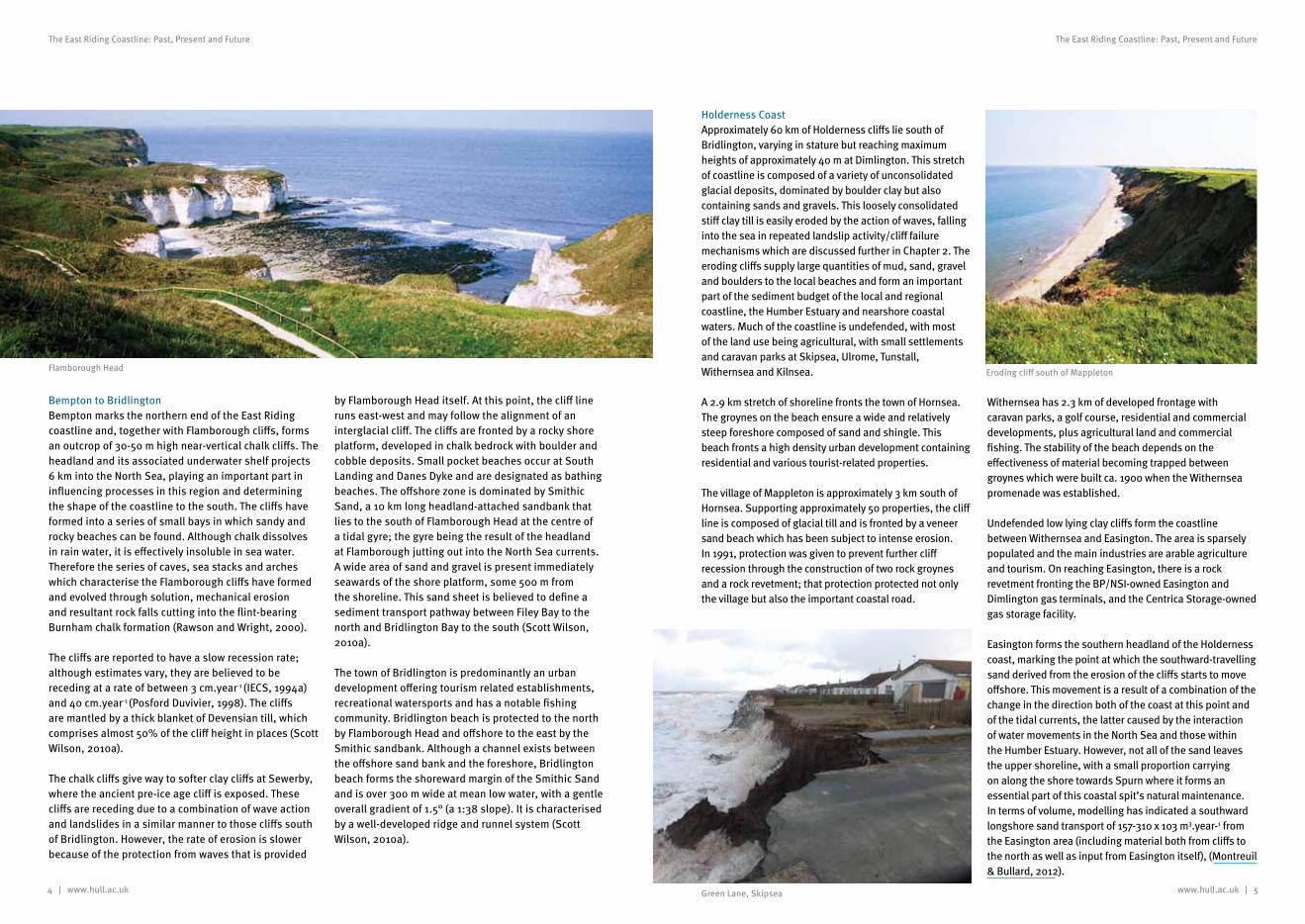
Bempton to BridlingtonBempton marks the northern end of the East Riding coastline and, together with Flamborough cliffs, forms an outcrop of 30-50 m high near-vertical chalk cliffs. The headland and its associated underwater shelf projects 6 km into the North Sea, playing an important part in influencing processes in this region and determining the shape of the coastline to the south. The cliffs have formed into a series of small bays in which sandy and rocky beaches can be found. Although chalk dissolves in rain water, it is effectively insoluble in sea water. Therefore the series of caves, sea stacks and arches which characterise the Flamborough cliffs have formed and evolved through solution, mechanical erosion and resultant rock falls cutting into the flint-bearing Burnham chalk formation (Rawson and Wright, 2000).
The cliffs are reported to have a slow recession rate; although estimates vary, they are believed to be receding at a rate of between 3 cm.year-1 (IECS, 1994a) and 40 cm.year-1 (Posford Duvivier, 1998). The cliffs are mantled by a thick blanket of Devensian till, which comprises almost 50% of the cliff height in places (Scott Wilson, 2010a).
The chalk cliffs give way to softer clay cliffs at Sewerby, where the ancient pre-ice age cliff is exposed. These cliffs are receding due to a combination of wave action and landslides in a similar manner to those cliffs south of Bridlington. However, the rate of erosion is slower because of the protection from waves that is provided
by Flamborough Head itself. At this point, the cliff line runs east-west and may follow the alignment of an interglacial cliff. The cliffs are fronted by a rocky shore platform, developed in chalk bedrock with boulder and cobble deposits. Small pocket beaches occur at South Landing and Danes Dyke and are designated as bathing beaches. The offshore zone is dominated by Smithic Sand, a 10 km long headland-attached sandbank that lies to the south of Flamborough Head at the centre of a tidal gyre; the gyre being the result of the headland at Flamborough jutting out into the North Sea currents. A wide area of sand and gravel is present immediately seawards of the shore platform, some 500 m from the shoreline. This sand sheet is believed to define a sediment transport pathway between Filey Bay to the north and Bridlington Bay to the south (Scott Wilson, 2010a).
The town of Bridlington is predominantly an urban development offering tourism related establishments, recreational watersports and has a notable fishing community. Bridlington beach is protected to the north by Flamborough Head and offshore to the east by the Smithic sandbank. Although a channel exists between the offshore sand bank and the foreshore, Bridlington beach forms the shoreward margin of the Smithic Sand and is over 300 m wide at mean low water, with a gentle overall gradient of 1.5° (a 1:38 slope). It is characterised by a well-developed ridge and runnel system (Scott Wilson, 2010a).
Holderness Coast Approximately 60 km of Holderness cliffs lie south of Bridlington, varying in stature but reaching maximum heights of approximately 40 m at Dimlington. This stretch of coastline is composed of a variety of unconsolidated glacial deposits, dominated by boulder clay but also containing sands and gravels. This loosely consolidated stiff clay till is easily eroded by the action of waves, falling into the sea in repeated landslip activity/cliff failure mechanisms which are discussed further in Chapter 2. The eroding cliffs supply large quantities of mud, sand, gravel and boulders to the local beaches and form an important part of the sediment budget of the local and regional coastline, the Humber Estuary and nearshore coastal waters. Much of the coastline is undefended, with most of the land use being agricultural, with small settlements and caravan parks at Skipsea, Ulrome, Tunstall, Withernsea and Kilnsea.
A 2.9 km stretch of shoreline fronts the town of Hornsea. The groynes on the beach ensure a wide and relatively steep foreshore composed of sand and shingle. This beach fronts a high density urban development containing residential and various tourist-related properties.
The village of Mappleton is approximately 3 km south of Hornsea. Supporting approximately 50 properties, the cliff line is composed of glacial till and is fronted by a veneer sand beach which has been subject to intense erosion. In 1991, protection was given to prevent further cliff recession through the construction of two rock groynes and a rock revetment; that protection protected not only the village but also the important coastal road.
Withernsea has 2.3 km of developed frontage with caravan parks, a golf course, residential and commercial developments, plus agricultural land and commercial fishing. The stability of the beach depends on the effectiveness of material becoming trapped between groynes which were built ca. 1900 when the Withernsea promenade was established.
Undefended low lying clay cliffs form the coastline between Withernsea and Easington. The area is sparsely populated and the main industries are arable agriculture and tourism. On reaching Easington, there is a rock revetment fronting the BP/NSI-owned Easington and Dimlington gas terminals, and the Centrica Storage-owned gas storage facility.
Easington forms the southern headland of the Holderness coast, marking the point at which the southward-travelling sand derived from the erosion of the cliffs starts to move offshore. This movement is a result of a combination of the change in the direction both of the coast at this point and of the tidal currents, the latter caused by the interaction of water movements in the North Sea and those within the Humber Estuary. However, not all of the sand leaves the upper shoreline, with a small proportion carrying on along the shore towards Spurn where it forms an essential part of this coastal spit’s natural maintenance. In terms of volume, modelling has indicated a southward longshore sand transport of 157-310 x 103 m3.year-1 from the Easington area (including material both from cliffs to the north as well as input from Easington itself), (Montreuil & Bullard, 2012).
Flamborough Head Eroding cliff south of Mappleton
Green Lane, Skipsea
6 | www.hull.ac.uk www.hull.ac.uk | 7
The East Riding Coastline: Past, Present and Future The East Riding Coastline: Past, Present and Future
Studies suggest that 3–6% of the eroded cliff material from the Holderness coastline is transported to the southern end of the region and incorporated into the Spurn Head spit, whilst the remainder is deposited in the nearshore and offshore zones (Valentin, 1971; Ciavola, 1997). Whilst the littoral1 drift may input 30–60 × 103 m³.year-1 to the spit, Montreuil and Bullard (2012) show that erosion from north of Spurn has the potential to supply 1.5 × 10³ m³.year-1 to areas downdrift. The principal pathway of bedload sediment material is southwards towards the nearshore sand banks of The Binks.
The peninsula has been cited as a text-book example of a spit – that is, a tongue of sand carried out into the mouth of a bay or estuary by longshore drift. However, recent research suggests that things are more complex than this. The macrotidal2 range (6 m) and high tidal current velocities at the Humber Estuary mouth are much too large for the development of a spit – with all other spits in the UK developing under a tidal range of between 2 m and 4 m. Spurn started to form from material from the eroding Holderness cliffs about 6,000 years ago. The sediment, moving in a southerly direction, settled in the lee of the cliffs forming a sand bank that steadily grew south-westerly in direction. The Binks gave added protection against waves and currents, allowing Spurn to stabilise and grow.
Spurn has long been recognised as a very dynamic feature undergoing cyclic breaching, destruction and reformation (de Boer, 1964). Although the spit is currently continuous with the coastline, historical records indicate a series of breaches of the peninsula. Erosion at the root and neck of the peninsula start a process of decay that ultimately leads to its destruction. For example, in 1849 Spurn was breached just north of the lighthouse as the result of a storm. By 1850, the breach was 450 m wide and 5 m deep at high water, allowing vessels to access the North Sea from the Humber Estuary. This breach was sealed by the construction of a chalk bank.
Using historical records, de Boer (1967, 1968 & 1981), a Professor of Geography at the University of Hull, argued that the destruction and rebirth of Spurn follows a 250 year cycle. The breaches on which de Boer based his theory occurred in 1360, 1600 and 1849. However, other scientists at the Institute of Estuarine and Coastal Studies (IECS) at Hull University challenged this, suggesting that the present-day morphology of Spurn results from extensive coast protection works constructed in the 1850-60s that followed a number of breaches of the spit in the 1840s (IECS, 1992). A consequence of these defences is that the central part of the spit has not moved whilst the landward end moves westward, matching the erosion of the Holderness coast. The defences also serve to fix the mean high water level along the peninsula, delaying the erosion process, thereby affecting the natural evolution of the peninsula (Sistermans & Nieuwenhuis, 2007).
Another potential contributor to the 1849 breach was the extensive removal of gravel from intertidal areas in the 18th and 19th centuries (ABPmer, 1998). In the mid 19th Century, 40,000 to 45,000 tonnes of sediment were being removed annually from the narrow northern area for use in construction. This volume of sediment removal relates to approximately seven times the natural erosion rate calculated by IECS (1992).
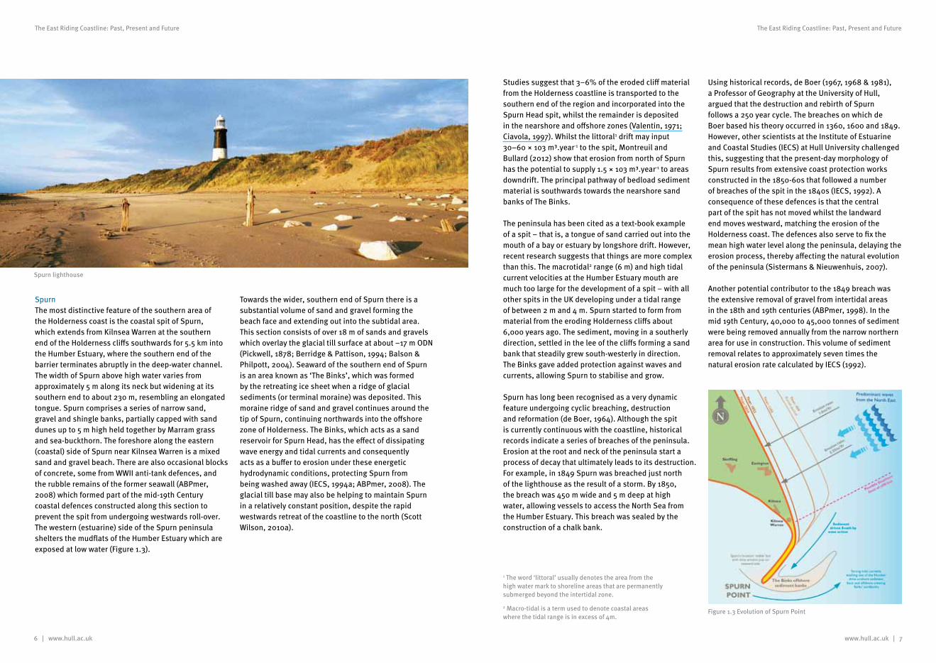
SpurnThe most distinctive feature of the southern area of the Holderness coast is the coastal spit of Spurn, which extends from Kilnsea Warren at the southern end of the Holderness cliffs southwards for 5.5 km into the Humber Estuary, where the southern end of the barrier terminates abruptly in the deep-water channel. The width of Spurn above high water varies from approximately 5 m along its neck but widening at its southern end to about 230 m, resembling an elongated tongue. Spurn comprises a series of narrow sand, gravel and shingle banks, partially capped with sand dunes up to 5 m high held together by Marram grass and sea-buckthorn. The foreshore along the eastern (coastal) side of Spurn near Kilnsea Warren is a mixed sand and gravel beach. There are also occasional blocks of concrete, some from WWII anti-tank defences, and the rubble remains of the former seawall (ABPmer, 2008) which formed part of the mid-19th Century coastal defences constructed along this section to prevent the spit from undergoing westwards roll-over. The western (estuarine) side of the Spurn peninsula shelters the mudflats of the Humber Estuary which are exposed at low water (Figure 1.3).
Towards the wider, southern end of Spurn there is a substantial volume of sand and gravel forming the beach face and extending out into the subtidal area. This section consists of over 18 m of sands and gravels which overlay the glacial till surface at about –17 m ODN (Pickwell, 1878; Berridge & Pattison, 1994; Balson & Philpott, 2004). Seaward of the southern end of Spurn is an area known as ‘The Binks’, which was formed by the retreating ice sheet when a ridge of glacial sediments (or terminal moraine) was deposited. This moraine ridge of sand and gravel continues around the tip of Spurn, continuing northwards into the offshore zone of Holderness. The Binks, which acts as a sand reservoir for Spurn Head, has the effect of dissipating wave energy and tidal currents and consequently acts as a buffer to erosion under these energetic hydrodynamic conditions, protecting Spurn from being washed away (IECS, 1994a; ABPmer, 2008). The glacial till base may also be helping to maintain Spurn in a relatively constant position, despite the rapid westwards retreat of the coastline to the north (Scott Wilson, 2010a).
Figure 1.3 Evolution of Spurn Point
1 The word ‘littoral’ usually denotes the area from the high water mark to shoreline areas that are permanently submerged beyond the intertidal zone.
2 Macro-tidal is a term used to denote coastal areas where the tidal range is in excess of 4m.
Spurn lighthouse
www.hull.ac.uk | 9
The East Riding Coastline: Past, Present and Future
8 | www.hull.ac.uk
The East Riding Coastline: Past, Present and Future
However, following escalating maintenance costs, the decision was taken in 1961 to abandon the defences and allow natural processes to again occur. The sandy ridge had remained for over 100 years, but only in the shelter of the groynes and sea walls that had been built to protect them. Over the past few decades, these defences have deteriorated and the immediate result has been very large erosion of the neck of Spurn so that today it is only a few metres wide and there are fears for its continued existence. In 1996 a severe storm caused a significant breach of the dunes. Although this was quickly filled, sections of the access road along the spit were washed away, leading to the subsequent realignment of the access road.
In 1810, a lifeboat station was founded on the tip of Spurn. This has since been the home to the UK’s only full-time lifeboat crew and their families. However,
due to continuous erosion and breaching of the peninsula, the road leading to the station has become increasingly impassable and a decision was taken in 2012 to relocate the families inland. In August 2012, the last of the families left the station and the homes now accommodate dormitories and offices to house the lifeboat crew when on duty.
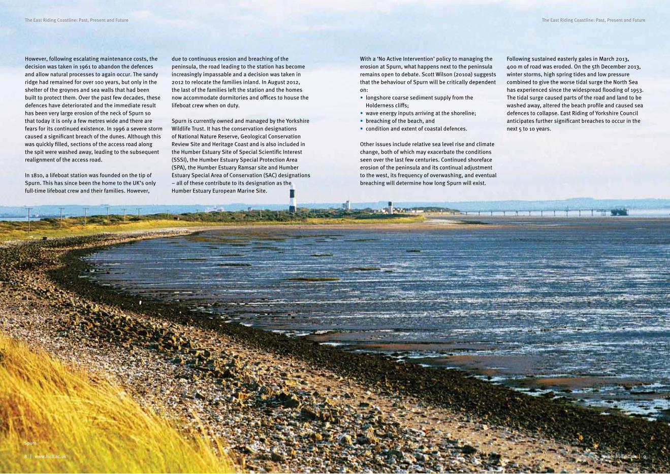
Spurn is currently owned and managed by the Yorkshire Wildlife Trust. It has the conservation designations of National Nature Reserve, Geological Conservation Review Site and Heritage Coast and is also included in the Humber Estuary Site of Special Scientific Interest (SSSI), the Humber Estuary Special Protection Area (SPA), the Humber Estuary Ramsar site and Humber Estuary Special Area of Conservation (SAC) designations – all of these contribute to its designation as the Humber Estuary European Marine Site.
With a ‘No Active Intervention’ policy to managing the erosion at Spurn, what happens next to the peninsula remains open to debate. Scott Wilson (2010a) suggests that the behaviour of Spurn will be critically dependent on:• longshore coarse sediment supply from the
Holderness cliffs;• wave energy inputs arriving at the shoreline;• breaching of the beach, and• condition and extent of coastal defences.
Other issues include relative sea level rise and climate change, both of which may exacerbate the conditions seen over the last few centuries. Continued shoreface erosion of the peninsula and its continual adjustment to the west, its frequency of overwashing, and eventual breaching will determine how long Spurn will exist.
Following sustained easterly gales in March 2013, 400 m of road was eroded. On the 5th December 2013, winter storms, high spring tides and low pressure combined to give the worse tidal surge the North Sea has experienced since the widespread flooding of 1953. The tidal surge caused parts of the road and land to be washed away, altered the beach profile and caused sea defences to collapse. East Riding of Yorkshire Council anticipates further significant breaches to occur in the next 5 to 10 years.
Spurn
www.hull.ac.uk | 11
The East Riding Coastline: Past, Present and Future
10 | www.hull.ac.uk
The East Riding Coastline: Past, Present and Future
Coastal processesChapter 2
Coastal processes on the East Riding coastline
Examining the processes at work along the coastline not only helps us to understand how erosion occurs, but also how we can manage the system and take informed decisions for the future. Much work has been carried out along the East Riding coastline, notably within Futurecoast (Halcrow, 2002), the Southern North Sea Sediment Transport Study (SNSSTS) (HR Wallingford 2002) and the Humber Estuary Coastal Authorities Group (HECAG) Flamborough Head to Gibraltar Point Shoreline Management Plan (SMP) (Scott Wilson, 2010a, b). Information is from various East Riding of Yorkshire Council documents, to research studies undertaken as part of the Land-Ocean Interaction Study (LOIS) which focussed on Holocene changes on the east coast of England (see, for example, Shennan & Andrews, 2000) and other scientific papers.
The East Riding coastline is subject to rapid changes with erosion, occurring in some places, on an observable scale. Annual monitoring shows that although the rates fluctuate along the coastline both from year to year and within the year, the overall loss of land through cliff recession along this coast is often quoted as being one of the fastest in Europe, averaging 2 m.year-1 (ERYC, 2013a). Whilst this natural process of change could eventually lead to a mature and more stable coast it will, in the meantime, potentially cause significant problems to those who live and work near it.
Geology
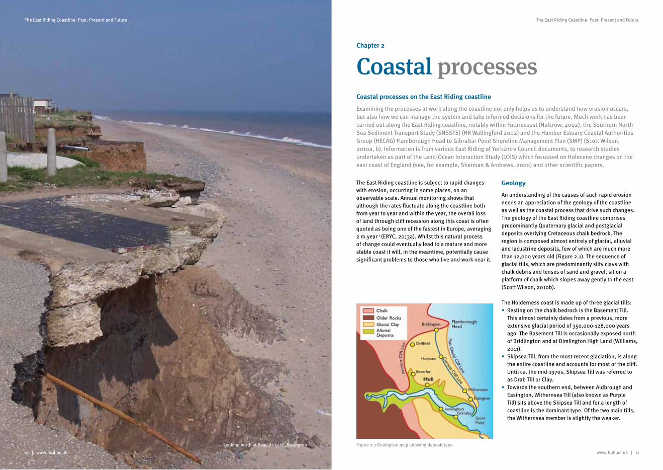
An understanding of the causes of such rapid erosion needs an appreciation of the geology of the coastline as well as the coastal process that drive such changes. The geology of the East Riding coastline comprises predominantly Quaternary glacial and postglacial deposits overlying Cretaceous chalk bedrock. The region is composed almost entirely of glacial, alluvial and lacustrine deposits, few of which are much more than 12,000 years old (Figure 2.1). The sequence of glacial tills, which are predominantly silty clays with chalk debris and lenses of sand and gravel, sit on a platform of chalk which slopes away gently to the east (Scott Wilson, 2010b).
The Holderness coast is made up of three glacial tills: • Resting on the chalk bedrock is the Basement Till.
This almost certainly dates from a previous, more extensive glacial period of 350,000-128,000 years ago. The Basement Till is occasionally exposed north of Bridlington and at Dimlington High Land (Williams, 2011).
• Skipsea Till, from the most recent glaciation, is along the entire coastline and accounts for most of the cliff. Until ca. the mid-1970s, Skipsea Till was referred to as Drab Till or Clay.
• Towards the southern end, between Aldbrough and Easington, Withernsea Till (also known as Purple Till) sits above the Skipsea Till and for a length of coastline is the dominant type. Of the two main tills, the Withernsea member is slightly the weaker.
Looking north at Seaside Lane, Easington Figure 2.1 Geological map showing deposit type
www.hull.ac.uk | 13
The East Riding Coastline: Past, Present and Future
12 | www.hull.ac.uk
The East Riding Coastline: Past, Present and Future
Much literature states that both Skipsea Till and the Withernsea Till were transported and deposited during the last glaciation in the Devensian period (18,000-13,000 years ago) (Bell & Forster, 1991; Bell, 2002; HR Wallingford, 2002; Quinn et al., 2009; Pye & Blott, 2010 and Quinn et al., 2010). Bell and Forster (1991) and Bell (2002) have proposed that the glacier which delivered these tills is considered composite or two-tier in that the ice originated from two sources: north and north-west. Both flows may have moved together, one overriding the other, or there may have been a re-advance. Whatever the case, each flow carried its own defining till (Williams, 2011).
The glacial tills, which consists of about 72% mud/silt, 27% sand and 1% boulders and large pebbles (Catt & Penny, 1966; Madgett & Catt, 1978; Balson & Phillpot, 2004), have very little resistance to erosion, especially when wet. Within and between the tills there are pockets and beds of sands, silts (especially at Dimlington High Land) and gravels, as well as small and occasionally larger boulders, or ‘erratics’.
Beaches
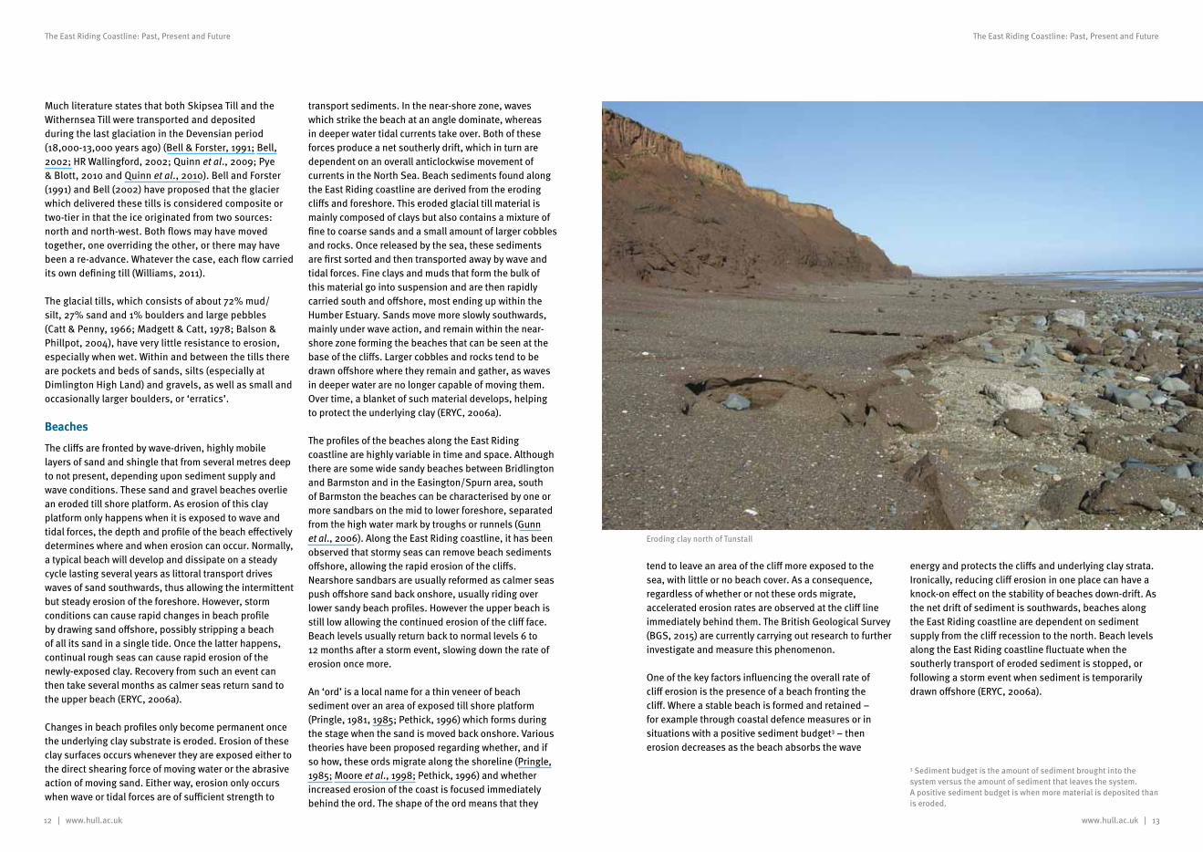
The cliffs are fronted by wave-driven, highly mobile layers of sand and shingle that from several metres deep to not present, depending upon sediment supply and wave conditions. These sand and gravel beaches overlie an eroded till shore platform. As erosion of this clay platform only happens when it is exposed to wave and tidal forces, the depth and profile of the beach effectively determines where and when erosion can occur. Normally, a typical beach will develop and dissipate on a steady cycle lasting several years as littoral transport drives waves of sand southwards, thus allowing the intermittent but steady erosion of the foreshore. However, storm conditions can cause rapid changes in beach profile by drawing sand offshore, possibly stripping a beach of all its sand in a single tide. Once the latter happens, continual rough seas can cause rapid erosion of the newly-exposed clay. Recovery from such an event can then take several months as calmer seas return sand to the upper beach (ERYC, 2006a).
Changes in beach profiles only become permanent once the underlying clay substrate is eroded. Erosion of these clay surfaces occurs whenever they are exposed either to the direct shearing force of moving water or the abrasive action of moving sand. Either way, erosion only occurs when wave or tidal forces are of sufficient strength to
transport sediments. In the near-shore zone, waves which strike the beach at an angle dominate, whereas in deeper water tidal currents take over. Both of these forces produce a net southerly drift, which in turn are dependent on an overall anticlockwise movement of currents in the North Sea. Beach sediments found along the East Riding coastline are derived from the eroding cliffs and foreshore. This eroded glacial till material is mainly composed of clays but also contains a mixture of fine to coarse sands and a small amount of larger cobbles and rocks. Once released by the sea, these sediments are first sorted and then transported away by wave and tidal forces. Fine clays and muds that form the bulk of this material go into suspension and are then rapidly carried south and offshore, most ending up within the Humber Estuary. Sands move more slowly southwards, mainly under wave action, and remain within the near-shore zone forming the beaches that can be seen at the base of the cliffs. Larger cobbles and rocks tend to be drawn offshore where they remain and gather, as waves in deeper water are no longer capable of moving them. Over time, a blanket of such material develops, helping to protect the underlying clay (ERYC, 2006a).
The profiles of the beaches along the East Riding coastline are highly variable in time and space. Although there are some wide sandy beaches between Bridlington and Barmston and in the Easington/Spurn area, south of Barmston the beaches can be characterised by one or more sandbars on the mid to lower foreshore, separated from the high water mark by troughs or runnels (Gunn et al., 2006). Along the East Riding coastline, it has been observed that stormy seas can remove beach sediments offshore, allowing the rapid erosion of the cliffs. Nearshore sandbars are usually reformed as calmer seas push offshore sand back onshore, usually riding over lower sandy beach profiles. However the upper beach is still low allowing the continued erosion of the cliff face. Beach levels usually return back to normal levels 6 to 12 months after a storm event, slowing down the rate of erosion once more.
An ‘ord’ is a local name for a thin veneer of beach sediment over an area of exposed till shore platform (Pringle, 1981, 1985; Pethick, 1996) which forms during the stage when the sand is moved back onshore. Various theories have been proposed regarding whether, and if so how, these ords migrate along the shoreline (Pringle, 1985; Moore et al., 1998; Pethick, 1996) and whether increased erosion of the coast is focused immediately behind the ord. The shape of the ord means that they
3 Sediment budget is the amount of sediment brought into the system versus the amount of sediment that leaves the system. A positive sediment budget is when more material is deposited than is eroded.
tend to leave an area of the cliff more exposed to the sea, with little or no beach cover. As a consequence, regardless of whether or not these ords migrate, accelerated erosion rates are observed at the cliff line immediately behind them. The British Geological Survey (BGS, 2015) are currently carrying out research to further investigate and measure this phenomenon.
One of the key factors influencing the overall rate of cliff erosion is the presence of a beach fronting the cliff. Where a stable beach is formed and retained – for example through coastal defence measures or in situations with a positive sediment budget3 – then erosion decreases as the beach absorbs the wave
energy and protects the cliffs and underlying clay strata. Ironically, reducing cliff erosion in one place can have a knock-on effect on the stability of beaches down-drift. As the net drift of sediment is southwards, beaches along the East Riding coastline are dependent on sediment supply from the cliff recession to the north. Beach levels along the East Riding coastline fluctuate when the southerly transport of eroded sediment is stopped, or following a storm event when sediment is temporarily drawn offshore (ERYC, 2006a).
Eroding clay north of Tunstall
14 | www.hull.ac.uk
The East Riding Coastline: Past, Present and Future
www.hull.ac.uk | 15
The East Riding Coastline: Past, Present and Future
Waves, Currents and Tides
The dominant waves along the Holderness coast are from the north-northeast and have a fetch of up to 900 km. The wave heights vary along this coastline due to several factors, including the shelter provided by Flamborough Head and additional shoaling and wave-refraction effects, caused by the shallow depths offshore of Spurn Head. In addition, there are changes in the exposure of the coastline between Flamborough Head and Spurn Head with a slight change in coastal orientation along the coast. The overall effect of these factors is for wave heights to reach a maximum around Easington. The 1 in 100 year wave height for the Holderness Coast has been calculated to be between 4 and 8 m, decreasing in size from Flamborough Head southwards towards Gibraltar Point in Lincolnshire (Anglian Water, 1988).
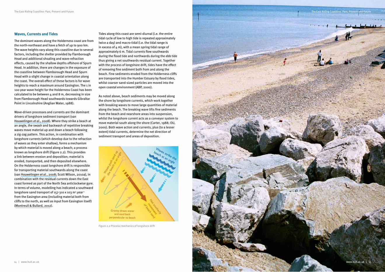
Wave-driven processes and currents are the dominant drivers of longshore sediment transport (van Houwelingen et al., 2008). Where they strike a beach at an angle, the swash and backwash of repetitive breaking waves move material up and down a beach following a zig-zag pattern. This action, in combination with longshore currents (which develop due to the refraction of waves as they enter shallow), forms a mechanism by which material is moved along a beach; a process known as longshore drift (Figure 2.2). This provides a link between erosion and deposition; material is eroded, transported, and then deposited elsewhere. On the Holderness coast longshore drift is responsible for transporting material southwards along the coast (van Houwelingen et al., 2008; Scott Wilson, 2010a), in combination with the residual currents down the East coast formed as part of the North Sea anticlockwise gyre. In terms of volume, modelling has indicated a southward longshore sand transport of 157-310 x 103 m3.year-1 from the Easington area (including material both from cliffs to the north, as well as input from Easington itself) (Montreuil & Bullard, 2012).
Tides along this coast are semi-diurnal (i.e. the entire tidal cycle of low to high tide is repeated approximately twice a day) and macro-tidal (i.e. the tidal range is in excess of 4 m), with a mean spring tidal range of approximately 6 m. Tidal currents flow southwards during the flood tide and northwards during the ebb tide thus giving a net southwards residual current. Together with the process of longshore drift, tides have the effect of removing fine sediment both from and along the beach. Fine sediments eroded from the Holderness cliffs are transported into the Humber Estuary by flood tides, whilst coarser sand-sized particles are moved into the open coastal environment (ABP, 2000).
As noted above, beach sediments may be moved along the shore by longshore currents, which work together with breaking waves to move large quantities of material along the beach. The breaking wave lifts fine sediments from the beach and nearshore areas into suspension, whilst the longshore current acts as a conveyor system to move material south along the shore (Carter, 1988; OU, 2000). Both wave action and currents, plus (to a lesser extent) tidal currents, determine the net direction of sediment transport and areas of deposition.
Figure 2.2 Process/mechanics of longshore drift
Withernsea beach
16 | www.hull.ac.uk www.hull.ac.uk | 17
The East Riding Coastline: Past, Present and Future The East Riding Coastline: Past, Present and Future
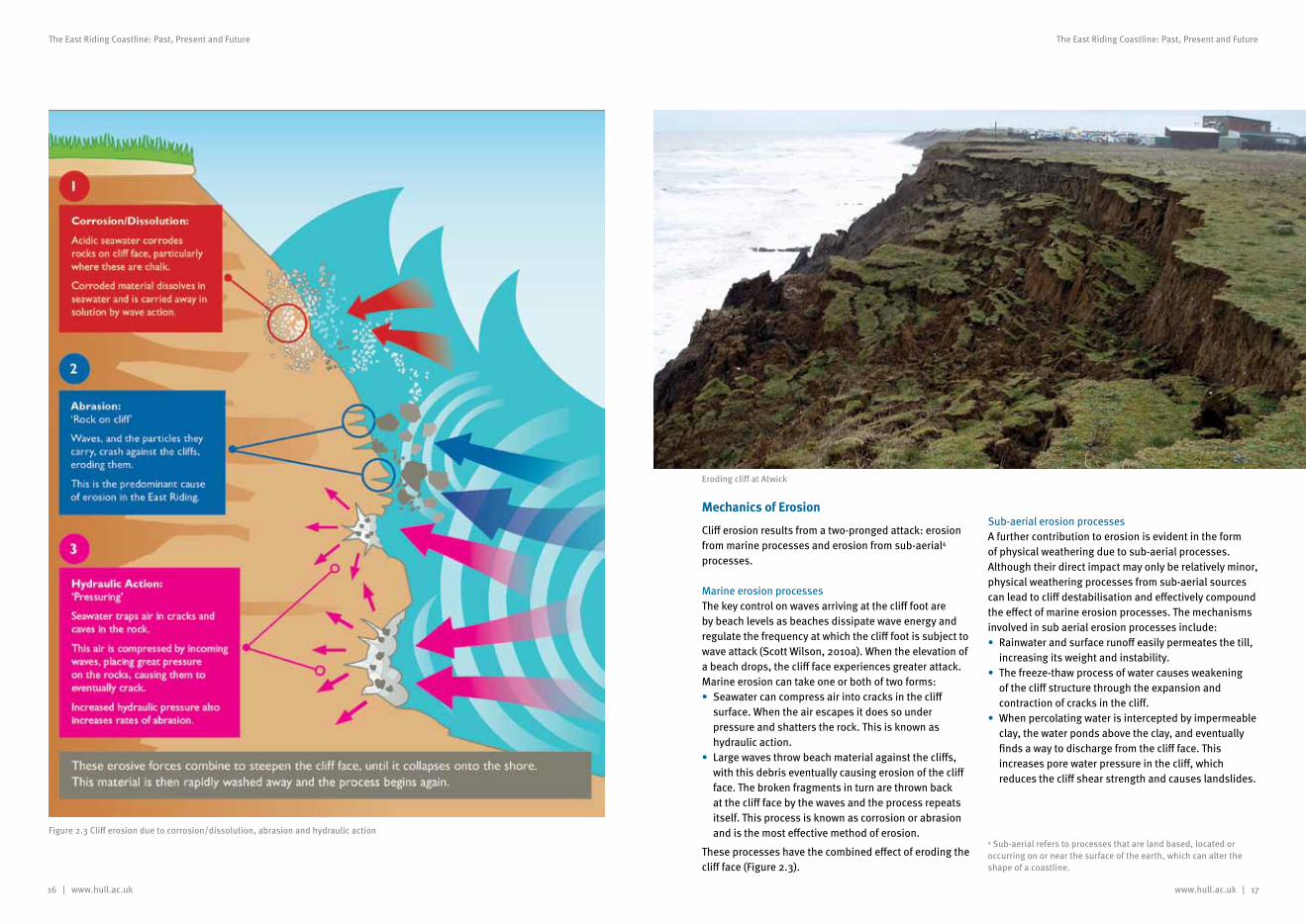
Figure 2.3 Cliff erosion due to corrosion/dissolution, abrasion and hydraulic action
Mechanics of Erosion
Cliff erosion results from a two-pronged attack: erosion from marine processes and erosion from sub-aerial4 processes.
Marine erosion processesThe key control on waves arriving at the cliff foot are by beach levels as beaches dissipate wave energy and regulate the frequency at which the cliff foot is subject to wave attack (Scott Wilson, 2010a). When the elevation of a beach drops, the cliff face experiences greater attack. Marine erosion can take one or both of two forms:• Seawater can compress air into cracks in the cliff
surface. When the air escapes it does so under pressure and shatters the rock. This is known as hydraulic action.
• Large waves throw beach material against the cliffs, with this debris eventually causing erosion of the cliff face. The broken fragments in turn are thrown back at the cliff face by the waves and the process repeats itself. This process is known as corrosion or abrasion and is the most effective method of erosion.
These processes have the combined effect of eroding the cliff face (Figure 2.3).
Sub-aerial erosion processesA further contribution to erosion is evident in the form of physical weathering due to sub-aerial processes. Although their direct impact may only be relatively minor, physical weathering processes from sub-aerial sources can lead to cliff destabilisation and effectively compound the effect of marine erosion processes. The mechanisms involved in sub aerial erosion processes include:• Rainwater and surface runoff easily permeates the till,
increasing its weight and instability.• The freeze-thaw process of water causes weakening
of the cliff structure through the expansion and contraction of cracks in the cliff.
• When percolating water is intercepted by impermeable clay, the water ponds above the clay, and eventually finds a way to discharge from the cliff face. This increases pore water pressure in the cliff, which reduces the cliff shear strength and causes landslides.
Eroding clay north of Tunstall
Eroding cliff at Atwick
4 Sub-aerial refers to processes that are land based, located or occurring on or near the surface of the earth, which can alter the shape of a coastline.
18 | www.hull.ac.uk www.hull.ac.uk | 19
The East Riding Coastline: Past, Present and Future The East Riding Coastline: Past, Present and Future
Types of cliff failureCliff failure and recession reflect a balance between the strength of the cliff materials and the stresses that are imposed on the cliff both by gravity and by the action of waves at the cliff foot. The cliffs of the East Riding coastline have two characteristics which are important when considering their rate of erosion. Firstly, the soft heterogeneous material has a low shear strength, which means the cliffs are vulnerable to wave erosion and failure caused by undercutting and the subsequent removal of that debris (Quinn et al., 2009; Scott Wilson, 2010a). Secondly, although the sand and gravel components of the glacial deposits are permeable, clays are not. The glacial tills that form the cliffs are composed of a mix of sand/cobbles and clay that are generally well mixed, resulting in a relatively impermeable structure. However, some sand lenses may occur and where water seeps into and collects within such porous areas, it can increase the pore water pressure within the cliff and reduce its shear strength. In itself this may ultimately lead to cliff failure through landslides, although this is only rarely observed. Whilst groundwater may contribute to cliff failure, wave action is the predominant cause of cliff erosion on the Holderness coast.
Cliff failure mechanisms typically include falls, slumps and mudslides, with some rotational and wedge failures (Pickwell, 1878; Hutchinson, 1986; Richards, 1987). The different types of cliff failure seen along the East Riding coastline include: • Falls: These generally occur as short-term failures
of steep slopes in strong clays. Tension cracks form behind the fall, and the collection of water in these can reduce stability. The size and manner of the fall can be strongly influenced by the presence of joints and fissures.
• Rotational slides: This is a more common failure in cliffs of homogenous clay but may also occur in heterogeneous glacial clays. The depth to length ratio is usually in the range 0.15 to 0.33. The deeper and larger slippages tend to develop in steeper slopes such as cuttings and actively eroding cliffs. The shape of the slip surface is usually circular in homogenous slopes and non-circular where there is weathering.
• Compound slides: These occur where the slip surface has both curved and straight portions and where there is variation in material at moderate depth in the slope.
Cliff retreat along the East Riding coastlineCliff retreat is often episodic, with short-term periods of rapid retreat, amounting to several metres, associated with major cliff failures, alternating with periods of relative stability which can last several years. Retreat occurs through the combined influence of direct (marine) erosion of the cliff, together with shallow, structural failures (slope movements that occur along discontinuities in the rock or soil mass often resulting in <2.5 m of clifftop incision) or substantial mass failures (slope movements that occur due to structural failure(s) within intact soil material). Cliff height appears to have little effect on whether a cliff fails due to sub-aerial or marine erosion processes. The failure of a cliff is essentially down to structural instability caused by a combination of both these processes.
Looking south at Seaside Lane, Easington
Sediment Budget
Shoreline processes are influenced by the sediment budget, i.e. the balance between material added to the shore by depositions and its removal by erosion. As only a relatively small portion of sediment is driven around Flamborough Head the sediment inputs to the beaches of Holderness are largely restricted to those from cliff and shore platform erosion (Reid, 1885; Valentin, 1954; IECS, 1994a). The sediment budget is made up of erosion from the cliff face, the beach (near shore zone) and the offshore clay face. Although there are only a few measurements of shore platform erosion, this area appears to be eroding at approximately the same rate of retreat as the main cliff line; an average of 1.7 m.year-1 (ERYC, 2006a).
Sediment transport (a wave-driven process) typically moves material in a southerly direction throughout this length of coast (Figure 2.4). Flamborough Head in the north effectively inhibits the majority of bedload movement from the north, whilst the deep-water channel of the Humber Estuary prevents any sand inputs from the south (Alkyon, 1999). Consequently, with the exception of Bridlington, the beaches of the East Riding depend on the erosion of the cliffs to the north for their supply of sediment. The finer grained sediments are considered to make a significant contribution to the sediment budgets of the Humber Estuary, the Wash and the coasts of southern eastern North Sea countries such as the Wadden Sea countries, due to the anti-clockwise currents in the southern North Sea (Ducrotoy et al., 2000).
Using topographic profiles for all the cliffed sections of the East Riding coastline, Montreuil and Bullard (2012) calculated that the retreating cliffs have lost 1,004,755 m³.year−1 of sediment since their initial survey in the mid-1990s. This rate agrees with the estimate of 1 × 10⁶ m3.year−1 (from 1852 to 1952) by Valentin (1971), whereas ABP (1996) predicted a slightly higher cliff erosion rate of up to 1.4 × 10⁶ m3.year−1. The combined sediment losses from both the cliffs and the shoreface along the East Riding coastline are estimated to be approximately 2.5 – 3.0 × 10⁶ m3.year−1 (ABP, 1996; Balson et al., 1996, 1998; Sistermans & Nieuwenhuis, 2007), which increases to 3.9 – 4.7 × 10⁶ m3.year−1 if the lower seabed to the limit of erosion is included (Wingfield & Evans, 1998). Of this eroded material, 60–80% are clays and silts, whilst the rest is predominantly sand and gravels (Balson & Harrison,
1988; Blewett & Huntley, 1998; Townend & Whitehead, 2003). Balson et al. (1998) estimated that 33% of the sediment is eroded from the cliff, and 67% from the shorefaces and seabed.
Previous studies suggest that 3–6% of the eroded cliff material is transported to the southern end of Holderness and incorporated into the Spurn Head spit whilst the remainder is deposited in the nearshore and offshore zones (Valentin, 1971; Ciavola, 1997). Whilst the littoral drift may input between 30 – 60 × 103 m³.year-1 to the spit, Montreuil and Bullard (2012) show that erosion from north Spurn Head may supply a sediment budget of 1.5 × 10³ m³.year-1 to areas downdrift. The principal pathway of bedload sediment material is southwards towards the nearshore sand banks of The Binks, which act as a sand reservoir for Spurn Head and a buffer to erosion under energetic hydrodynamic conditions.
Figure 2.4 North Sea current patterns (adapted from Turrell et al., 1992)
20 | www.hull.ac.uk www.hull.ac.uk | 21
The East Riding Coastline: Past, Present and Future The East Riding Coastline: Past, Present and Future
Erosion Rates
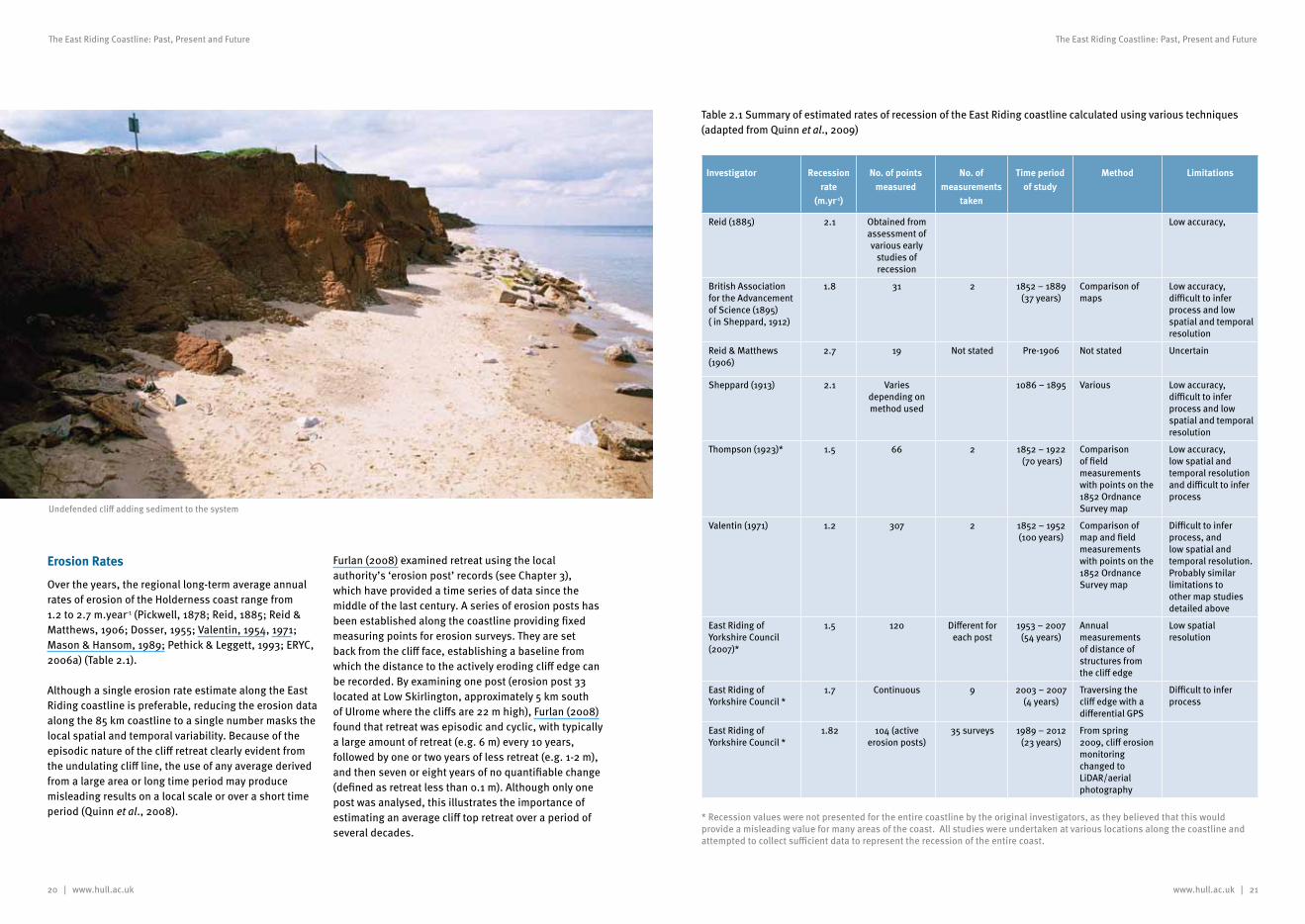
Over the years, the regional long-term average annual rates of erosion of the Holderness coast range from 1.2 to 2.7 m.year-1 (Pickwell, 1878; Reid, 1885; Reid & Matthews, 1906; Dosser, 1955; Valentin, 1954, 1971; Mason & Hansom, 1989; Pethick & Leggett, 1993; ERYC, 2006a) (Table 2.1).
Although a single erosion rate estimate along the East Riding coastline is preferable, reducing the erosion data along the 85 km coastline to a single number masks the local spatial and temporal variability. Because of the episodic nature of the cliff retreat clearly evident from the undulating cliff line, the use of any average derived from a large area or long time period may produce misleading results on a local scale or over a short time period (Quinn et al., 2008).
Furlan (2008) examined retreat using the local authority’s ‘erosion post’ records (see Chapter 3), which have provided a time series of data since the middle of the last century. A series of erosion posts has been established along the coastline providing fixed measuring points for erosion surveys. They are set back from the cliff face, establishing a baseline from which the distance to the actively eroding cliff edge can be recorded. By examining one post (erosion post 33 located at Low Skirlington, approximately 5 km south of Ulrome where the cliffs are 22 m high), Furlan (2008) found that retreat was episodic and cyclic, with typically a large amount of retreat (e.g. 6 m) every 10 years, followed by one or two years of less retreat (e.g. 1-2 m), and then seven or eight years of no quantifiable change (defined as retreat less than 0.1 m). Although only one post was analysed, this illustrates the importance of estimating an average cliff top retreat over a period of several decades.
Undefended cliff adding sediment to the system
Investigator Recession rate
(m.yr-1)
No. of points measured
No. of measurements
taken
Time period of study
Method Limitations
Reid (1885) 2.1 Obtained from assessment of various early
studies of recession
Low accuracy,
British Association for the Advancement of Science (1895) ( in Sheppard, 1912)
1.8 31 2 1852 – 1889 (37 years)
Comparison of maps
Low accuracy, difficult to infer process and low spatial and temporal resolution
Reid & Matthews (1906)
2.7 19 Not stated Pre-1906 Not stated Uncertain
Sheppard (1913) 2.1 Varies depending on method used
1086 – 1895 Various Low accuracy, difficult to infer process and low spatial and temporal resolution
Thompson (1923)* 1.5 66 2 1852 – 1922 (70 years)
Comparison of field measurements with points on the 1852 Ordnance Survey map
Low accuracy, low spatial and temporal resolution and difficult to infer process
Valentin (1971) 1.2 307 2 1852 – 1952 (100 years)
Comparison of map and field measurements with points on the 1852 Ordnance Survey map
Difficult to infer process, and low spatial and temporal resolution. Probably similar limitations to other map studies detailed above
East Riding of Yorkshire Council (2007)*
1.5 120 Different for each post
1953 – 2007 (54 years)
Annual measurements of distance of structures from the cliff edge
Low spatial resolution
East Riding of Yorkshire Council *
1.7 Continuous 9 2003 – 2007 (4 years)
Traversing the cliff edge with a differential GPS
Difficult to infer process
East Riding of Yorkshire Council *
1.82 104 (active erosion posts)
35 surveys 1989 – 2012(23 years)
From spring 2009, cliff erosion monitoring changed to LiDAR/aerial photography
Table 2.1 Summary of estimated rates of recession of the East Riding coastline calculated using various techniques (adapted from Quinn et al., 2009)
* Recession values were not presented for the entire coastline by the original investigators, as they believed that this would provide a misleading value for many areas of the coast. All studies were undertaken at various locations along the coastline and attempted to collect sufficient data to represent the recession of the entire coast.
22 | www.hull.ac.uk
The East Riding Coastline: Past, Present and Future
Stormy sea at Spurn
www.hull.ac.uk | 23
The East Riding Coastline: Past, Present and Future
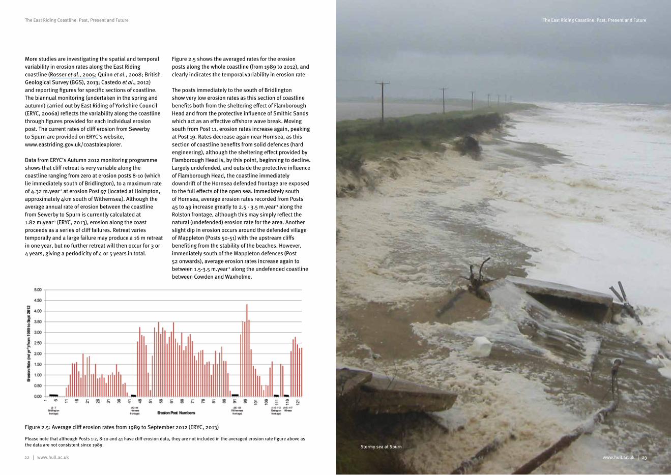
More studies are investigating the spatial and temporal variability in erosion rates along the East Riding coastline (Rosser et al., 2005; Quinn et al., 2008; British Geological Survey (BGS), 2013; Castedo et al., 2012) and reporting figures for specific sections of coastline. The biannual monitoring (undertaken in the spring and autumn) carried out by East Riding of Yorkshire Council (ERYC, 2006a) reflects the variability along the coastline through figures provided for each individual erosion post. The current rates of cliff erosion from Sewerby to Spurn are provided on ERYC’s website, www.eastriding.gov.uk/coastalexplorer.
Data from ERYC’s Autumn 2012 monitoring programme shows that cliff retreat is very variable along the coastline ranging from zero at erosion posts 8-10 (which lie immediately south of Bridlington), to a maximum rate of 4.32 m.year-1 at erosion Post 97 (located at Holmpton, approximately 4km south of Withernsea). Although the average annual rate of erosion between the coastline from Sewerby to Spurn is currently calculated at 1.82 m.year-1 (ERYC, 2013), erosion along the coast proceeds as a series of cliff failures. Retreat varies temporally and a large failure may produce a 16 m retreat in one year, but no further retreat will then occur for 3 or 4 years, giving a periodicity of 4 or 5 years in total.
Figure 2.5 shows the averaged rates for the erosion posts along the whole coastline (from 1989 to 2012), and clearly indicates the temporal variability in erosion rate.
The posts immediately to the south of Bridlington show very low erosion rates as this section of coastline benefits both from the sheltering effect of Flamborough Head and from the protective influence of Smithic Sands which act as an effective offshore wave break. Moving south from Post 11, erosion rates increase again, peaking at Post 19. Rates decrease again near Hornsea, as this section of coastline benefits from solid defences (hard engineering), although the sheltering effect provided by Flamborough Head is, by this point, beginning to decline. Largely undefended, and outside the protective influence of Flamborough Head, the coastline immediately downdrift of the Hornsea defended frontage are exposed to the full effects of the open sea. Immediately south of Hornsea, average erosion rates recorded from Posts 45 to 49 increase greatly to 2.5 - 3.5 m.year-1 along the Rolston frontage, although this may simply reflect the natural (undefended) erosion rate for the area. Another slight dip in erosion occurs around the defended village of Mappleton (Posts 50-51) with the upstream cliffs benefiting from the stability of the beaches. However, immediately south of the Mappleton defences (Post 52 onwards), average erosion rates increase again to between 1.5-3.5 m.year-1 along the undefended coastline between Cowden and Waxholme.
Please note that although Posts 1-2, 8-10 and 41 have cliff erosion data, they are not included in the averaged erosion rate figure above as the data are not consistent since 1989.
Figure 2.5: Average cliff erosion rates from 1989 to September 2012 (ERYC, 2013)
24 | www.hull.ac.uk
The East Riding Coastline: Past, Present and Future
www.hull.ac.uk | 25
The East Riding Coastline: Past, Present and Future
Solid defences at Withernsea are thought to be responsible for the low rate of erosion to the north (Post 89), whilst erosion to the south from Post 94 shows the highest rates along the entire coastline peaking at an average of 4.32 m.year-1 at Post 97 (located opposite sewage works off Holmpton Road, Holmpton). Despite the influx of beach material from the north, erosion rates in this area are still the highest along the entire coastline. The coastline to the south of Kilnsea (Posts 118-123) also shows relatively high erosion rates, averaging between 2.11 and 2.78 m.year-1. In general terms, the further south one moves down the Holderness coast the more any sheltering influence from Flamborough Head is weakened and, because of the gradual change in the orientation of the coastline relative to prevailing north-easterly storms, the more exposed the coast becomes, leading to a general underlying increase in erosion rates.
The IPCC (2007) and Masselink and Russell (2010) suggest that these erosion rates are likely to increase in the future due to sea level rises and increased storminess. Rises in sea level increase the exposure of the cliff base to wave action. In addition, the potential for coastal erosion increases with wave height (with waves reaching the cliff base more frequently), although wave period is also important (with steeper, wind-derived waves with short wave periods being more destructive than longer swell-derived waves with long wave periods). As the North Sea is characterised by high storm surges and short wave periods (Masselink and Russell, 2010), the coast in this area is likely to be adversely affected by any increase in storminess.
It has been predicted that the erosion of the Holderness coast will eventually come to a natural halt some 5,000 to 10,000 years from now, when the coastline reaches the ancient chalk coastline that currently forms the edge of the Yorkshire Wolds. The position of the final coastline and therefore the time taken to reach it will depend upon the rate and amount of sea level rise (ERYC, 2006a).
Provisional statistics from the Met Office show 2012 was the second wettest year in the UK national record dating back to 1910, with warnings that the UK may face more extreme rainfall events in the future (Met Office, 2013). Although the 2012 summer cliff erosion rates were slightly higher than normal for a summer season, they were still within the normal annual variation.
Old sea defences at Spurn
www.hull.ac.uk | 27
The East Riding Coastline: Past, Present and Future
The effect of this rise in sea level has been compounded more recently by an additional rise due to the effects of climate change. Melting of polar ice caps and ocean warming increase the volume of seawater, leading to an overall rise in sea levels (ERYC, 2006a). Global average sea level rose at approximately 1.8 mm.year-1 between 1961 and 2003, but has accelerated to 3.1 mm.year-1 in recent years (IPCC, 2007). The lowering of land levels in the East Riding area has effectively meant that sea levels are rising by up to 3 mm annually although the authorities such as the Environment Agency, for planning purposes, may use an operational figure higher than this.
Whilst there is uncertainty around the scale of future climate change and sea level rise, the rate of future sea level rise is expected to accelerate due to continued global warming and more rapid melting of the ice caps and ice sheets. Figures from Defra, presented in the HECAG SMP (Scott Wilson, 2010b), provide guidance on the potential magnitude of sea level rise that will be observed on the Holderness coast (see Table 2.2). These figures (which take account of scientific research undertaken by the Intergovernmental Panel on Climate Change, IPCC) suggest a total rise in sea level of just under 1 metre, relative to 2009 levels, by 2105.
26 | www.hull.ac.uk
The East Riding Coastline: Past, Present and Future
Impact of dredging on erosion rates
All human activities have the potential to affect the natural marine system. In recent decades, there have been proposals for dredging of the seabed at various places along the Holderness coastline. Dredging offshore has been suggested as possibly exacerbating coastal erosion. Water depth changes arising from aggregate dredging can change wave propagation over the dredged areas leading to changes in wave height and direction at the coast. This may, in turn, alter longshore sediment transport processes, thereby indirectly causing coastal erosion or realignment (Tillin et al., 2011).
However, various studies have recently been carried out to assess whether dredging makes surrounding areas more prone to erosion (The Crown Estate & BMAPA, 2013). For example, the Southern North Sea Sediment Transport Study (SNSSTS) aimed to increase confidence in the collective understanding of sediment movement, coastal processes and the impact of dredging on the east coast. Its results show that, whilst dredging may have had an impact in the past due to its occurrence much closer to the coast, because dredging is now strictly controlled and carefully managed in UK waters (for example by reducing the incidence of dredging close inshore and permitting it only in areas that are outside of the sediment transport zones), it no longer has an impact on coastal erosion (HR Wallingford, 2002). Tillin et al. (2011) also conclude that the current licensing process excludes dredging activities from areas where adverse changes to erosion patterns could occur, ensuring that this does not take place. Providing that the licenced area is located in water deeper than approximately 14 m, any changes to the physical environment, e.g. changes in wave conditions, will be negligible and highly localised.
The management of dredging now also ensures that there is no exchange of sediment between the active nearshore sediment transport zone and active dredge areas that remove ancient sand banks or gravel lag deposits deposited during glacial or interglacial periods, especially in the relict river channels running through the North Sea. This was the source of recent concern by residents at Withernsea who were worried that the proposed offshore gravel dredging would influence coastal erosion rates.
Marine aggregate extraction and disposal of dredged spoil is currently licensed and regulated by the Marine Management Organisation (MMO) in England, under the Marine and Coastal Access Act 2009. A licence is required for dredging and a thorough environmental impact assessment is required to ensure any dredging activity will not have a negative impact on the coastline or the marine environment before a licence is granted.
Sea Level Rise and Climate Change
Change in sea level is the combined result of isostatic and eustatic changes (Scott Wilson, 2010b). The isostatic component is produced by the gradual and long-term re-adjustment of the parts of NW Europe following the loss of the mass of glacial ice that covered the northern and central area of Great Britain and Scandinavia during the ice ages. At this time, the weight of ice forced the northern landmasses downwards causing land further south (including the area which is now East Yorkshire) to tilt up. The resultant effect of the removal of this loading has been for the land mass to ‘rebound’, with the north of Britain lifting up and the south sinking, possibly with a fulcrum around the Scottish Border. While there is debate about the relative amounts of isostatic rebound in parts of the NW Europe, there appears general agreement that it is occurring hence we talk of Relative Sea Level Rise as the changing sea levels against a background of the land sinking or rising.
The eustatic component represents an increase in sea water volume due to rises in global temperatures seen as a result of relatively recent climate change. The eustatic component comprises the combined effects of glacial melting and the thermal expansion of seawater due to rises in global temperatures. Whilst the isostatic component varies around the UK coast the eustatic component is relatively uniform (Figure 2.6).
Shennan et al. (2009) found that, over the past 1000 years, relative sea levels fell across the Humber region by around 0.3-0.5 mm.year-1 due to isostatic rebound. This trend has now reversed, with Townend et al. (2007) estimating mean sea level rise in the Humber Estuary as being 1.8 mm.year-1 (based on a tidal gauge from 1920 to 2000) which is 0.4 mm.year-1 higher than the UK average mean sea-level rise (based on Woodworth et al., 2009). Due to its geographical proximity, a similar rate might be expected on the adjacent Holderness coast (Brown et al., 2012).
Although sea level rise may be the main controlling factor regarding future changes to erosion rates, it is not the only factor controlling the rate of cliff retreat (e.g. Lim et al., 2010). Both storm frequency and magnitude are also predicted to increase due to the impacts of climate change, with a likely consequential increase in the rate of coastal erosion and frequency of flooding on low-lying coasts (Bindoff & Willebrand, 2007; Chini et al., 2010). Increased storminess together with changes to wave conditions will cause increased erosion by steepening intertidal profiles allowing greater wave attack of the cliffs.
Figure 2.6 Isostatic and Eustatic changes
Time period Net sea level rise (mm per
year)
Total sea level rise
over period (mm)
Cumulative sea
level rise (mm)
2009 – 2025 4.0 64 64
2026 – 2055 8.5 255 319
2056 – 2085 12.0 360 679
2086 – 2105 15.0 300 979
Table 2.2 Defra sea level rise guidance (East of England and East Midlands – south of Flamborough Head)
www.hull.ac.uk | 29
The East Riding Coastline: Past, Present and Future
Coastal monitoringChapter 3
28 | www.hull.ac.uk
The East Riding Coastline: Past, Present and Future
Why the Coastline is Monitored
It is axiomatic that anything that society does in the environment will have an effect on the natural system. We can usually assume that the natural system is in an equilibrium and so our actions may disturb that equilibrium as the system adjusts to new conditions. This is particularly shown by construction on the coast. By 1900, the early days of coastal construction saw rapid development of many coastal frontages. At that time the lack of design guidance and knowledge of coastal processes led to the spread of massive masonry or concrete seawalls. Little thought if any was given to how they impacted upon the frontage as a whole or how well they would perform in the long term. It is only quite recently with the development of monitoring techniques that feedback has enabled better informed decision-making (ERYC, 2006b).
In particular, any alteration to the line of the coast or any structure that is put in place to defend a coastline will, to some extent, impact upon the natural flow or supply of sand and so will affect local coastal processes in some way. These changes tend to be greatest immediately following the construction of the defences, particularly if they contain an element of beach control, such as a groyne field, and may persist until a new equilibrium is achieved which adjusts for the new shape of the coastline. Monitoring the surrounding beaches and adjacent cliff lines, both before and after the defences are constructed, can help to determine the extent and nature of these changes. Again it is axiomatic that whereas the natural system will adjust and not be affected by these changes, it is their impact on the human (built) environment that causes concern. Ultimately the degree to which such unintended changes become a problem will depend upon the size of the impact(s) and the sensitivity of the area (particularly the down-drift area) to short-term changes in sediment supply (ERYC, 2006b). The size and thus consequences of the impact relate to the duration (time), extent (area) and frequency of the changes.
To optimise the chances of a defence scheme succeeding it is therefore important to first gain a thorough understanding of the coastal processes in an area and possibly also in adjoining areas, both on the land and at sea. This can be done through the use of physical or theoretical modelling techniques and desk-top studies, although the most reliable results come from sites where regular monitoring surveys have been undertaken. Site-specific data of this kind provide valuable first-hand evidence, which allows direct interpretation or the fine-tuning of model-based studies. With this knowledge, schemes can be tailored to work within the natural system, taking advantage of underlying natural processes where beach control is required or reducing unwanted impacts further afield. In this way it should then be possible to get the best financial, social and engineering benefit from the new defences (ERYC, 2006b) and to understand the causes and consequences of changes on both the natural and human systems. Fundamental to this approach is the need to understand the natural local processes. Consequently, identifying and forecasting coastal erosion is essential for all those involved in coastal planning and shoreline management.
The North Sea
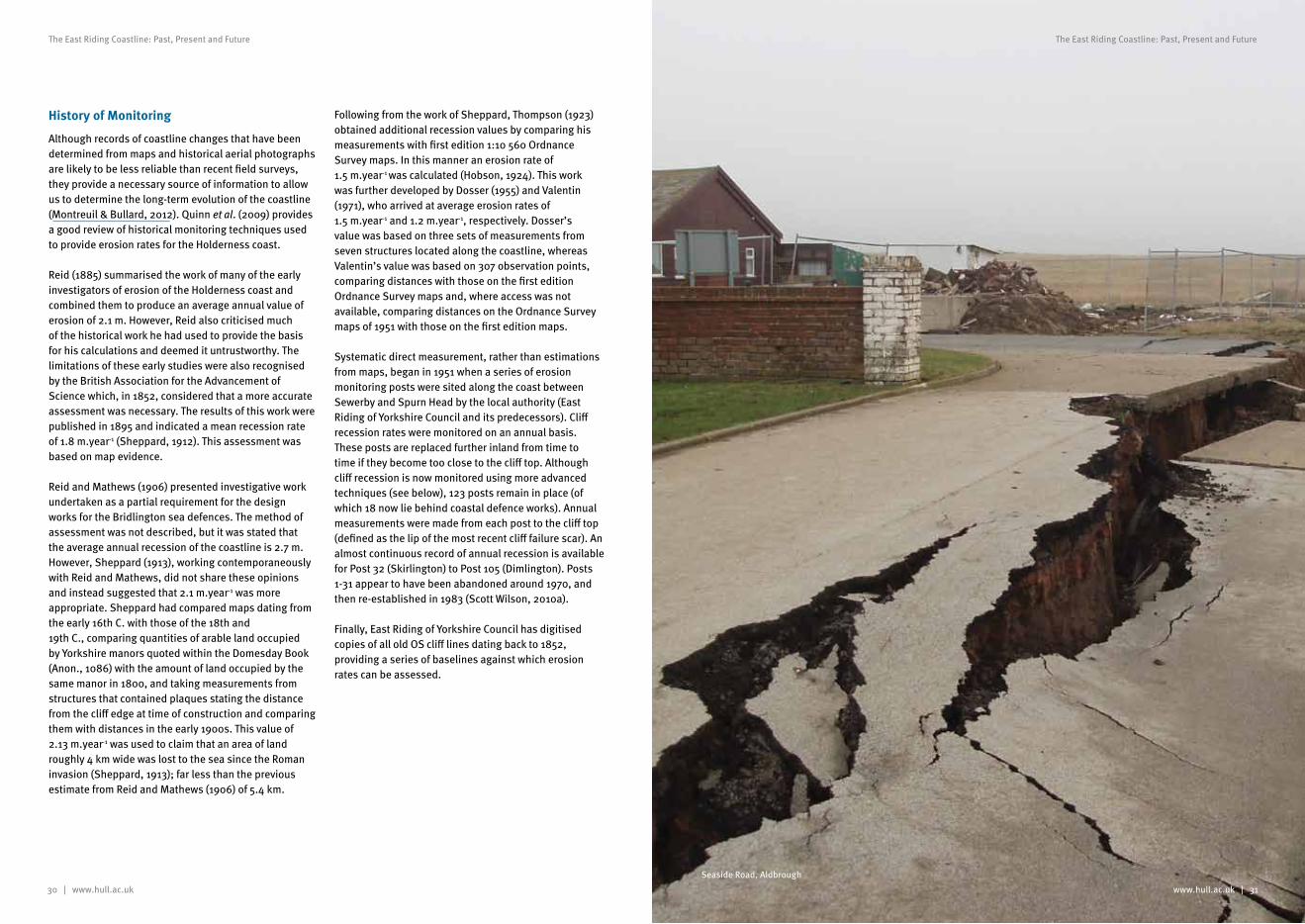
30 | www.hull.ac.uk
The East Riding Coastline: Past, Present and Future
www.hull.ac.uk | 31
The East Riding Coastline: Past, Present and Future
History of Monitoring
Although records of coastline changes that have been determined from maps and historical aerial photographs are likely to be less reliable than recent field surveys, they provide a necessary source of information to allow us to determine the long-term evolution of the coastline (Montreuil & Bullard, 2012). Quinn et al. (2009) provides a good review of historical monitoring techniques used to provide erosion rates for the Holderness coast.
Reid (1885) summarised the work of many of the early investigators of erosion of the Holderness coast and combined them to produce an average annual value of erosion of 2.1 m. However, Reid also criticised much of the historical work he had used to provide the basis for his calculations and deemed it untrustworthy. The limitations of these early studies were also recognised by the British Association for the Advancement of Science which, in 1852, considered that a more accurate assessment was necessary. The results of this work were published in 1895 and indicated a mean recession rate of 1.8 m.year-1 (Sheppard, 1912). This assessment was based on map evidence.
Reid and Mathews (1906) presented investigative work undertaken as a partial requirement for the design works for the Bridlington sea defences. The method of assessment was not described, but it was stated that the average annual recession of the coastline is 2.7 m. However, Sheppard (1913), working contemporaneously with Reid and Mathews, did not share these opinions and instead suggested that 2.1 m.year-1 was more appropriate. Sheppard had compared maps dating from the early 16th C. with those of the 18th and 19th C., comparing quantities of arable land occupied by Yorkshire manors quoted within the Domesday Book (Anon., 1086) with the amount of land occupied by the same manor in 1800, and taking measurements from structures that contained plaques stating the distance from the cliff edge at time of construction and comparing them with distances in the early 1900s. This value of 2.13 m.year-1 was used to claim that an area of land roughly 4 km wide was lost to the sea since the Roman invasion (Sheppard, 1913); far less than the previous estimate from Reid and Mathews (1906) of 5.4 km.
Following from the work of Sheppard, Thompson (1923) obtained additional recession values by comparing his measurements with first edition 1:10 560 Ordnance Survey maps. In this manner an erosion rate of 1.5 m.year-1 was calculated (Hobson, 1924). This work was further developed by Dosser (1955) and Valentin (1971), who arrived at average erosion rates of 1.5 m.year-1 and 1.2 m.year-1, respectively. Dosser’s value was based on three sets of measurements from seven structures located along the coastline, whereas Valentin’s value was based on 307 observation points, comparing distances with those on the first edition Ordnance Survey maps and, where access was not available, comparing distances on the Ordnance Survey maps of 1951 with those on the first edition maps.
Systematic direct measurement, rather than estimations from maps, began in 1951 when a series of erosion monitoring posts were sited along the coast between Sewerby and Spurn Head by the local authority (East Riding of Yorkshire Council and its predecessors). Cliff recession rates were monitored on an annual basis. These posts are replaced further inland from time to time if they become too close to the cliff top. Although cliff recession is now monitored using more advanced techniques (see below), 123 posts remain in place (of which 18 now lie behind coastal defence works). Annual measurements were made from each post to the cliff top (defined as the lip of the most recent cliff failure scar). An almost continuous record of annual recession is available for Post 32 (Skirlington) to Post 105 (Dimlington). Posts 1-31 appear to have been abandoned around 1970, and then re-established in 1983 (Scott Wilson, 2010a).
Finally, East Riding of Yorkshire Council has digitised copies of all old OS cliff lines dating back to 1852, providing a series of baselines against which erosion rates can be assessed.
Seaside Road, Aldbrough
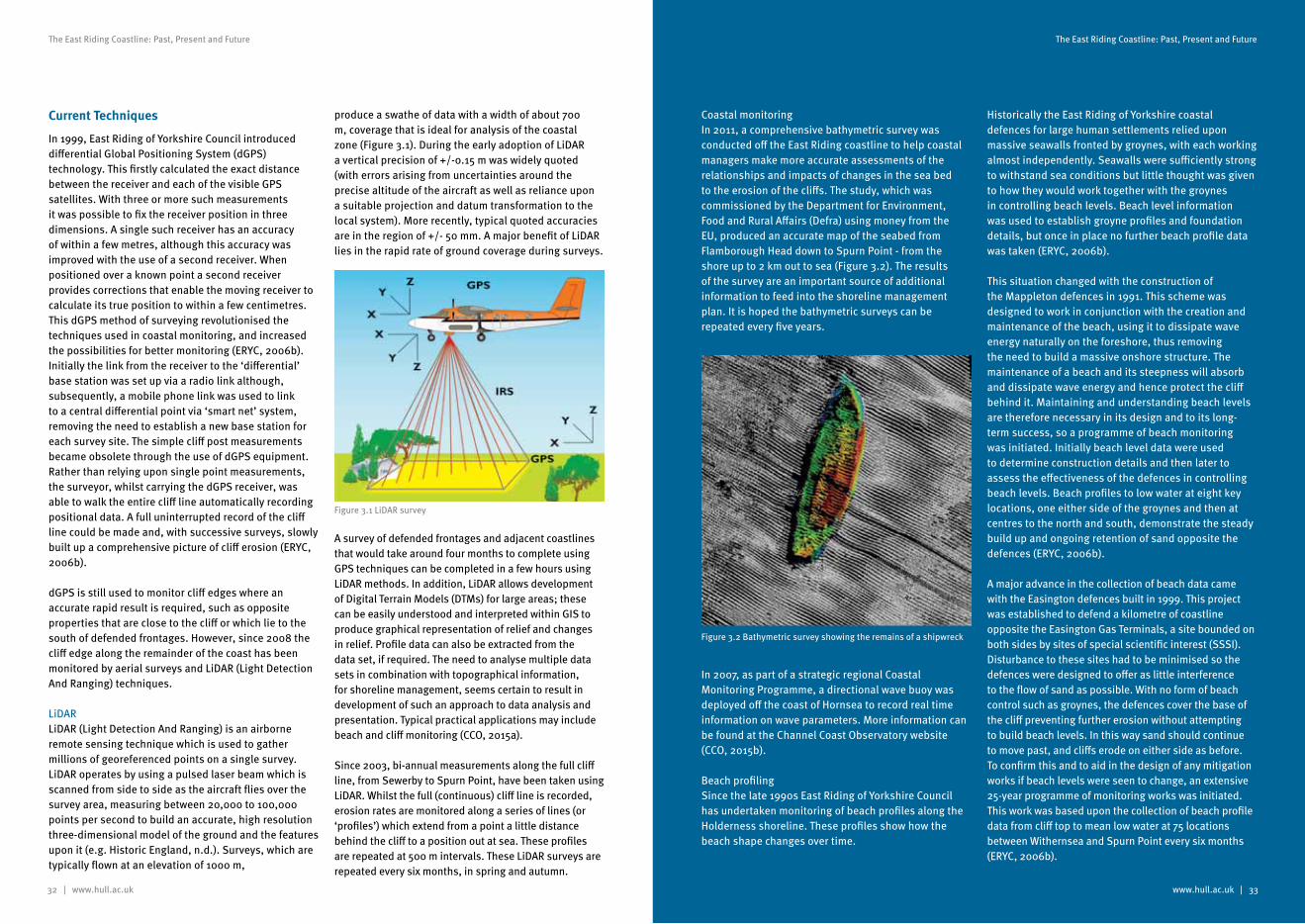
32 | www.hull.ac.uk
The East Riding Coastline: Past, Present and Future
www.hull.ac.uk | 33
The East Riding Coastline: Past, Present and Future
Current Techniques
In 1999, East Riding of Yorkshire Council introduced differential Global Positioning System (dGPS) technology. This firstly calculated the exact distance between the receiver and each of the visible GPS satellites. With three or more such measurements it was possible to fix the receiver position in three dimensions. A single such receiver has an accuracy of within a few metres, although this accuracy was improved with the use of a second receiver. When positioned over a known point a second receiver provides corrections that enable the moving receiver to calculate its true position to within a few centimetres. This dGPS method of surveying revolutionised the techniques used in coastal monitoring, and increased the possibilities for better monitoring (ERYC, 2006b). Initially the link from the receiver to the ‘differential’ base station was set up via a radio link although, subsequently, a mobile phone link was used to link to a central differential point via ‘smart net’ system, removing the need to establish a new base station for each survey site. The simple cliff post measurements became obsolete through the use of dGPS equipment. Rather than relying upon single point measurements, the surveyor, whilst carrying the dGPS receiver, was able to walk the entire cliff line automatically recording positional data. A full uninterrupted record of the cliff line could be made and, with successive surveys, slowly built up a comprehensive picture of cliff erosion (ERYC, 2006b).
dGPS is still used to monitor cliff edges where an accurate rapid result is required, such as opposite properties that are close to the cliff or which lie to the south of defended frontages. However, since 2008 the cliff edge along the remainder of the coast has been monitored by aerial surveys and LiDAR (Light Detection And Ranging) techniques.
LiDAR LiDAR (Light Detection And Ranging) is an airborne remote sensing technique which is used to gather millions of georeferenced points on a single survey. LiDAR operates by using a pulsed laser beam which is scanned from side to side as the aircraft flies over the survey area, measuring between 20,000 to 100,000 points per second to build an accurate, high resolution three-dimensional model of the ground and the features upon it (e.g. Historic England, n.d.). Surveys, which are typically flown at an elevation of 1000 m,
produce a swathe of data with a width of about 700 m, coverage that is ideal for analysis of the coastal zone (Figure 3.1). During the early adoption of LiDAR a vertical precision of +/-0.15 m was widely quoted (with errors arising from uncertainties around the precise altitude of the aircraft as well as reliance upon a suitable projection and datum transformation to the local system). More recently, typical quoted accuracies are in the region of +/- 50 mm. A major benefit of LiDAR lies in the rapid rate of ground coverage during surveys.
A survey of defended frontages and adjacent coastlines that would take around four months to complete using GPS techniques can be completed in a few hours using LiDAR methods. In addition, LiDAR allows development of Digital Terrain Models (DTMs) for large areas; these can be easily understood and interpreted within GIS to produce graphical representation of relief and changes in relief. Profile data can also be extracted from the data set, if required. The need to analyse multiple data sets in combination with topographical information, for shoreline management, seems certain to result in development of such an approach to data analysis and presentation. Typical practical applications may include beach and cliff monitoring (CCO, 2015a).
Since 2003, bi-annual measurements along the full cliff line, from Sewerby to Spurn Point, have been taken using LiDAR. Whilst the full (continuous) cliff line is recorded, erosion rates are monitored along a series of lines (or ‘profiles’) which extend from a point a little distance behind the cliff to a position out at sea. These profiles are repeated at 500 m intervals. These LiDAR surveys are repeated every six months, in spring and autumn.
Coastal monitoringIn 2011, a comprehensive bathymetric survey was conducted off the East Riding coastline to help coastal managers make more accurate assessments of the relationships and impacts of changes in the sea bed to the erosion of the cliffs. The study, which was commissioned by the Department for Environment, Food and Rural Affairs (Defra) using money from the EU, produced an accurate map of the seabed from Flamborough Head down to Spurn Point - from the shore up to 2 km out to sea (Figure 3.2). The results of the survey are an important source of additional information to feed into the shoreline management plan. It is hoped the bathymetric surveys can be repeated every five years.
In 2007, as part of a strategic regional Coastal Monitoring Programme, a directional wave buoy was deployed off the coast of Hornsea to record real time information on wave parameters. More information can be found at the Channel Coast Observatory website (CCO, 2015b).
Beach profilingSince the late 1990s East Riding of Yorkshire Council has undertaken monitoring of beach profiles along the Holderness shoreline. These profiles show how the beach shape changes over time.
Historically the East Riding of Yorkshire coastal defences for large human settlements relied upon massive seawalls fronted by groynes, with each working almost independently. Seawalls were sufficiently strong to withstand sea conditions but little thought was given to how they would work together with the groynes in controlling beach levels. Beach level information was used to establish groyne profiles and foundation details, but once in place no further beach profile data was taken (ERYC, 2006b).
This situation changed with the construction of the Mappleton defences in 1991. This scheme was designed to work in conjunction with the creation and maintenance of the beach, using it to dissipate wave energy naturally on the foreshore, thus removing the need to build a massive onshore structure. The maintenance of a beach and its steepness will absorb and dissipate wave energy and hence protect the cliff behind it. Maintaining and understanding beach levels are therefore necessary in its design and to its long-term success, so a programme of beach monitoring was initiated. Initially beach level data were used to determine construction details and then later to assess the effectiveness of the defences in controlling beach levels. Beach profiles to low water at eight key locations, one either side of the groynes and then at centres to the north and south, demonstrate the steady build up and ongoing retention of sand opposite the defences (ERYC, 2006b).
A major advance in the collection of beach data came with the Easington defences built in 1999. This project was established to defend a kilometre of coastline opposite the Easington Gas Terminals, a site bounded on both sides by sites of special scientific interest (SSSI). Disturbance to these sites had to be minimised so the defences were designed to offer as little interference to the flow of sand as possible. With no form of beach control such as groynes, the defences cover the base of the cliff preventing further erosion without attempting to build beach levels. In this way sand should continue to move past, and cliffs erode on either side as before. To confirm this and to aid in the design of any mitigation works if beach levels were seen to change, an extensive 25-year programme of monitoring works was initiated. This work was based upon the collection of beach profile data from cliff top to mean low water at 75 locations between Withernsea and Spurn Point every six months (ERYC, 2006b).
Figure 3.1 LiDAR survey
Figure 3.2 Bathymetric survey showing the remains of a shipwreck
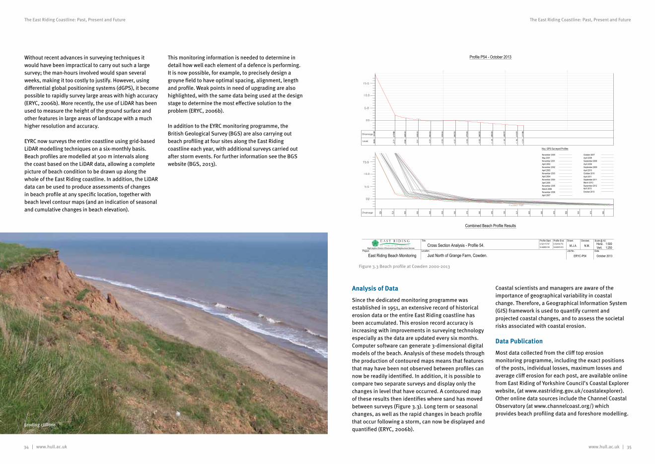
34 | www.hull.ac.uk
The East Riding Coastline: Past, Present and Future
www.hull.ac.uk | 35
The East Riding Coastline: Past, Present and Future
Without recent advances in surveying techniques it would have been impractical to carry out such a large survey; the man-hours involved would span several weeks, making it too costly to justify. However, using differential global positioning systems (dGPS), it become possible to rapidly survey large areas with high accuracy (ERYC, 2006b). More recently, the use of LiDAR has been used to measure the height of the ground surface and other features in large areas of landscape with a much higher resolution and accuracy.
EYRC now surveys the entire coastline using grid-based LiDAR modelling techniques on a six-monthly basis. Beach profiles are modelled at 500 m intervals along the coast based on the LiDAR data, allowing a complete picture of beach condition to be drawn up along the whole of the East Riding coastline. In addition, the LiDAR data can be used to produce assessments of changes in beach profile at any specific location, together with beach level contour maps (and an indication of seasonal and cumulative changes in beach elevation).
This monitoring information is needed to determine in detail how well each element of a defence is performing. It is now possible, for example, to precisely design a groyne field to have optimal spacing, alignment, length and profile. Weak points in need of upgrading are also highlighted, with the same data being used at the design stage to determine the most effective solution to the problem (ERYC, 2006b).
In addition to the EYRC monitoring programme, the British Geological Survey (BGS) are also carrying out beach profiling at four sites along the East Riding coastline each year, with additional surveys carried out after storm events. For further information see the BGS website (BGS, 2013).
Analysis of Data
Since the dedicated monitoring programme was established in 1951, an extensive record of historical erosion data or the entire East Riding coastline has been accumulated. This erosion record accuracy is increasing with improvements in surveying technology especially as the data are updated every six months.Computer software can generate 3-dimensional digital models of the beach. Analysis of these models through the production of contoured maps means that features that may have been not observed between profiles can now be readily identified. In addition, it is possible to compare two separate surveys and display only the changes in level that have occurred. A contoured map of these results then identifies where sand has moved between surveys (Figure 3.3). Long term or seasonal changes, as well as the rapid changes in beach profile that occur following a storm, can now be displayed and quantified (ERYC, 2006b).
Coastal scientists and managers are aware of the importance of geographical variability in coastal change. Therefore, a Geographical Information System (GIS) framework is used to quantify current and projected coastal changes, and to assess the societal risks associated with coastal erosion.
Data Publication
Most data collected from the cliff top erosion monitoring programme, including the exact positions of the posts, individual losses, maximum losses and average cliff erosion for each post, are available online from East Riding of Yorkshire Council’s Coastal Explorer website, (at www.eastriding.gov.uk/coastalexplorer). Other online data sources include the Channel Coastal Observatory (at www.channelcoast.org/) which provides beach profiling data and foreshore modelling.
November 2000May 2001November 2001April 2002November 2002April 2003November 2003April 2004November 2004April 2005November 2005March 2006November 2006April 2007
October 2007April 2008September 2008April 2009September 2009April 2010October 2010April 2011September 2011March 2012
Key: GPS Surveyed Profiles
Profile P54 - October 2013
Combined Beach Profile Results
September 2012April 2013October 2013
East Riding Beach Monitoring
Checked.
N.M.Location.
Just North of Grange Farm, Cowden.Date.
October 2013
Drawn.
M.J.A.Nigel Leighton Director of Environment and Neighbourhood Services
Profile Start. Profile End.
Project.
Title.
Job No.
Scale @ A2.Horiz. 1:500Vert. 1:250
ERYC-P54
Cross Section Analysis - Profile 54. E 523115.747N 442858.106
E 524194.772N 443619.515
Figure 3.3 Beach profile at Cowden 2000-2013
Eroding cliffline
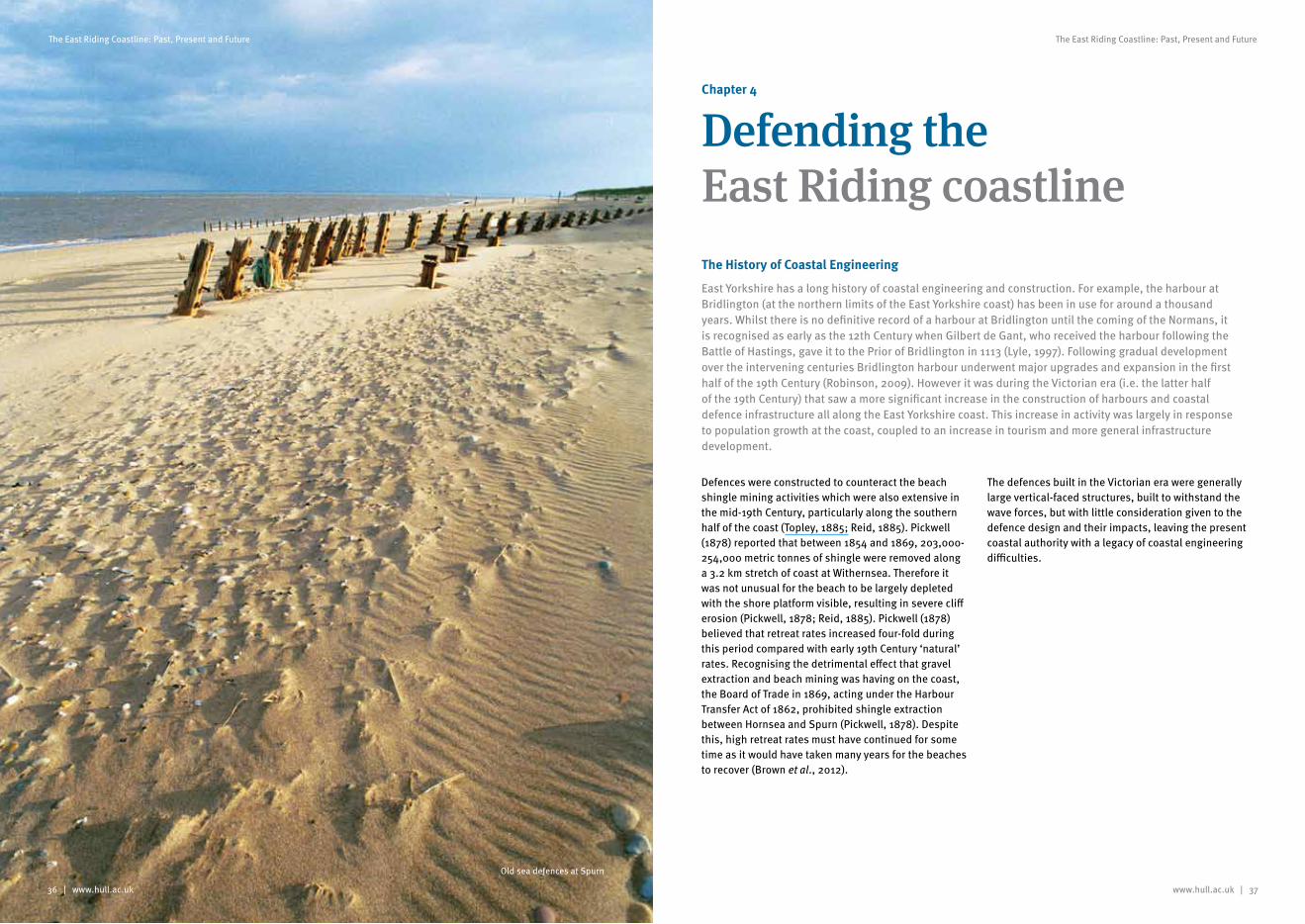
www.hull.ac.uk | 37
The East Riding Coastline: Past, Present and Future
36 | www.hull.ac.uk
The East Riding Coastline: Past, Present and Future
Chapter 4
Defending the East Riding coastlineThe History of Coastal Engineering
East Yorkshire has a long history of coastal engineering and construction. For example, the harbour at Bridlington (at the northern limits of the East Yorkshire coast) has been in use for around a thousand years. Whilst there is no definitive record of a harbour at Bridlington until the coming of the Normans, it is recognised as early as the 12th Century when Gilbert de Gant, who received the harbour following the Battle of Hastings, gave it to the Prior of Bridlington in 1113 (Lyle, 1997). Following gradual development over the intervening centuries Bridlington harbour underwent major upgrades and expansion in the first half of the 19th Century (Robinson, 2009). However it was during the Victorian era (i.e. the latter half of the 19th Century) that saw a more significant increase in the construction of harbours and coastal defence infrastructure all along the East Yorkshire coast. This increase in activity was largely in response to population growth at the coast, coupled to an increase in tourism and more general infrastructure development.
Defences were constructed to counteract the beach shingle mining activities which were also extensive in the mid-19th Century, particularly along the southern half of the coast (Topley, 1885; Reid, 1885). Pickwell (1878) reported that between 1854 and 1869, 203,000-254,000 metric tonnes of shingle were removed along a 3.2 km stretch of coast at Withernsea. Therefore it was not unusual for the beach to be largely depleted with the shore platform visible, resulting in severe cliff erosion (Pickwell, 1878; Reid, 1885). Pickwell (1878) believed that retreat rates increased four-fold during this period compared with early 19th Century ‘natural’ rates. Recognising the detrimental effect that gravel extraction and beach mining was having on the coast, the Board of Trade in 1869, acting under the Harbour Transfer Act of 1862, prohibited shingle extraction between Hornsea and Spurn (Pickwell, 1878). Despite this, high retreat rates must have continued for some time as it would have taken many years for the beaches to recover (Brown et al., 2012).
The defences built in the Victorian era were generally large vertical-faced structures, built to withstand the wave forces, but with little consideration given to the defence design and their impacts, leaving the present coastal authority with a legacy of coastal engineering difficulties.
Old sea defences at Spurn
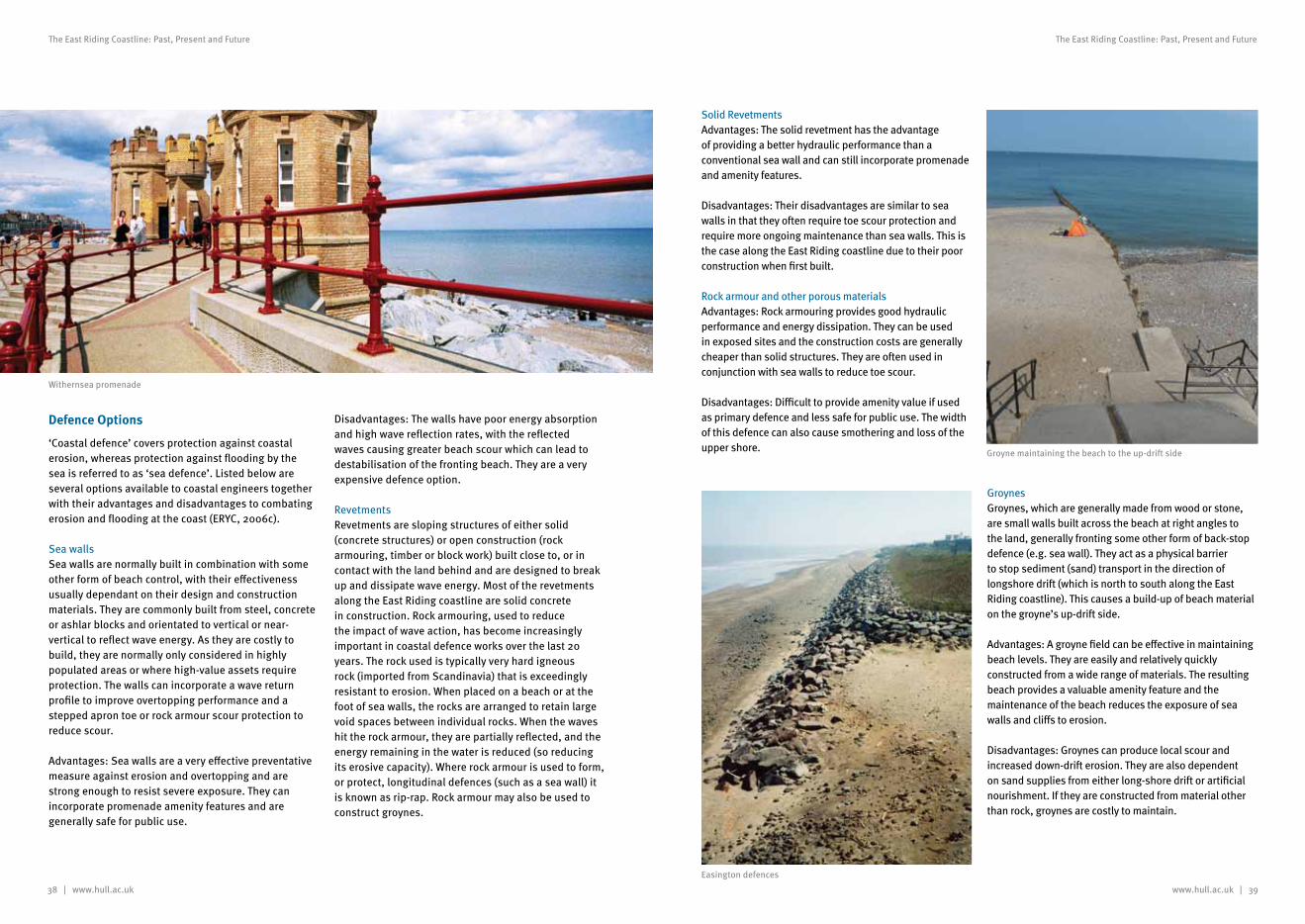
38 | www.hull.ac.uk www.hull.ac.uk | 39
The East Riding Coastline: Past, Present and Future The East Riding Coastline: Past, Present and Future
Defence Options
‘Coastal defence’ covers protection against coastal erosion, whereas protection against flooding by the sea is referred to as ‘sea defence’. Listed below are several options available to coastal engineers together with their advantages and disadvantages to combating erosion and flooding at the coast (ERYC, 2006c).
Sea wallsSea walls are normally built in combination with some other form of beach control, with their effectiveness usually dependant on their design and construction materials. They are commonly built from steel, concrete or ashlar blocks and orientated to vertical or near-vertical to reflect wave energy. As they are costly to build, they are normally only considered in highly populated areas or where high-value assets require protection. The walls can incorporate a wave return profile to improve overtopping performance and a stepped apron toe or rock armour scour protection to reduce scour.
Advantages: Sea walls are a very effective preventative measure against erosion and overtopping and are strong enough to resist severe exposure. They can incorporate promenade amenity features and are generally safe for public use.
Disadvantages: The walls have poor energy absorption and high wave reflection rates, with the reflected waves causing greater beach scour which can lead to destabilisation of the fronting beach. They are a very expensive defence option.
RevetmentsRevetments are sloping structures of either solid (concrete structures) or open construction (rock armouring, timber or block work) built close to, or in contact with the land behind and are designed to break up and dissipate wave energy. Most of the revetments along the East Riding coastline are solid concrete in construction. Rock armouring, used to reduce the impact of wave action, has become increasingly important in coastal defence works over the last 20 years. The rock used is typically very hard igneous rock (imported from Scandinavia) that is exceedingly resistant to erosion. When placed on a beach or at the foot of sea walls, the rocks are arranged to retain large void spaces between individual rocks. When the waves hit the rock armour, they are partially reflected, and the energy remaining in the water is reduced (so reducing its erosive capacity). Where rock armour is used to form, or protect, longitudinal defences (such as a sea wall) it is known as rip-rap. Rock armour may also be used to construct groynes.
Solid RevetmentsAdvantages: The solid revetment has the advantage of providing a better hydraulic performance than a conventional sea wall and can still incorporate promenade and amenity features.
Disadvantages: Their disadvantages are similar to sea walls in that they often require toe scour protection and require more ongoing maintenance than sea walls. This is the case along the East Riding coastline due to their poor construction when first built.
Rock armour and other porous materialsAdvantages: Rock armouring provides good hydraulic performance and energy dissipation. They can be used in exposed sites and the construction costs are generally cheaper than solid structures. They are often used in conjunction with sea walls to reduce toe scour.
Disadvantages: Difficult to provide amenity value if used as primary defence and less safe for public use. The width of this defence can also cause smothering and loss of the upper shore.
GroynesGroynes, which are generally made from wood or stone, are small walls built across the beach at right angles to the land, generally fronting some other form of back-stop defence (e.g. sea wall). They act as a physical barrier to stop sediment (sand) transport in the direction of longshore drift (which is north to south along the East Riding coastline). This causes a build-up of beach material on the groyne’s up-drift side.
Advantages: A groyne field can be effective in maintaining beach levels. They are easily and relatively quickly constructed from a wide range of materials. The resulting beach provides a valuable amenity feature and the maintenance of the beach reduces the exposure of sea walls and cliffs to erosion.
Disadvantages: Groynes can produce local scour and increased down-drift erosion. They are also dependent on sand supplies from either long-shore drift or artificial nourishment. If they are constructed from material other than rock, groynes are costly to maintain.
Withernsea promenade
Easington defences
Groyne maintaining the beach to the up-drift side
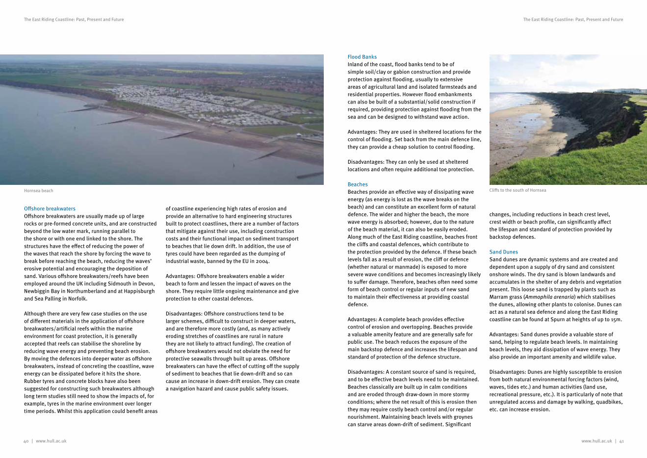
40 | www.hull.ac.uk
The East Riding Coastline: Past, Present and Future
www.hull.ac.uk | 41
The East Riding Coastline: Past, Present and Future
Offshore breakwatersOffshore breakwaters are usually made up of large rocks or pre-formed concrete units, and are constructed beyond the low water mark, running parallel to the shore or with one end linked to the shore. The structures have the effect of reducing the power of the waves that reach the shore by forcing the wave to break before reaching the beach, reducing the waves’ erosive potential and encouraging the deposition of sand. Various offshore breakwaters/reefs have been employed around the UK including Sidmouth in Devon, Newbiggin Bay in Northumberland and at Happisburgh and Sea Palling in Norfolk.
Although there are very few case studies on the use of different materials in the application of offshore breakwaters/artificial reefs within the marine environment for coast protection, it is generally accepted that reefs can stabilise the shoreline by reducing wave energy and preventing beach erosion. By moving the defences into deeper water as offshore breakwaters, instead of concreting the coastline, wave energy can be dissipated before it hits the shore. Rubber tyres and concrete blocks have also been suggested for constructing such breakwaters although long term studies still need to show the impacts of, for example, tyres in the marine environment over longer time periods. Whilst this application could benefit areas
of coastline experiencing high rates of erosion and provide an alternative to hard engineering structures built to protect coastlines, there are a number of factors that mitigate against their use, including construction costs and their functional impact on sediment transport to beaches that lie down drift. In addition, the use of tyres could have been regarded as the dumping of industrial waste, banned by the EU in 2004.
Advantages: Offshore breakwaters enable a wider beach to form and lessen the impact of waves on the shore. They require little ongoing maintenance and give protection to other coastal defences.
Disadvantages: Offshore constructions tend to be larger schemes, difficult to construct in deeper waters, and are therefore more costly (and, as many actively eroding stretches of coastlines are rural in nature they are not likely to attract funding). The creation of offshore breakwaters would not obviate the need for protective seawalls through built up areas. Offshore breakwaters can have the effect of cutting off the supply of sediment to beaches that lie down-drift and so can cause an increase in down-drift erosion. They can create a navigation hazard and cause public safety issues.
Flood BanksInland of the coast, flood banks tend to be of simple soil/clay or gabion construction and provide protection against flooding, usually to extensive areas of agricultural land and isolated farmsteads and residential properties. However flood embankments can also be built of a substantial/solid construction if required, providing protection against flooding from the sea and can be designed to withstand wave action.
Advantages: They are used in sheltered locations for the control of flooding. Set back from the main defence line, they can provide a cheap solution to control flooding.
Disadvantages: They can only be used at sheltered locations and often require additional toe protection.
BeachesBeaches provide an effective way of dissipating wave energy (as energy is lost as the wave breaks on the beach) and can constitute an excellent form of natural defence. The wider and higher the beach, the more wave energy is absorbed; however, due to the nature of the beach material, it can also be easily eroded. Along much of the East Riding coastline, beaches front the cliffs and coastal defences, which contribute to the protection provided by the defence. If these beach levels fall as a result of erosion, the cliff or defence (whether natural or manmade) is exposed to more severe wave conditions and becomes increasingly likely to suffer damage. Therefore, beaches often need some form of beach control or regular inputs of new sand to maintain their effectiveness at providing coastal defence.
Advantages: A complete beach provides effective control of erosion and overtopping. Beaches provide a valuable amenity feature and are generally safe for public use. The beach reduces the exposure of the main backstop defence and increases the lifespan and standard of protection of the defence structure.
Disadvantages: A constant source of sand is required, and to be effective beach levels need to be maintained. Beaches classically are built up in calm conditions and are eroded through draw-down in more stormy conditions; where the net result of this is erosion then they may require costly beach control and/or regular nourishment. Maintaining beach levels with groynes can starve areas down-drift of sediment. Significant
changes, including reductions in beach crest level, crest width or beach profile, can significantly affect the lifespan and standard of protection provided by backstop defences.
Sand DunesSand dunes are dynamic systems and are created and dependent upon a supply of dry sand and consistent onshore winds. The dry sand is blown landwards and accumulates in the shelter of any debris and vegetation present. This loose sand is trapped by plants such as Marram grass (Ammophila arenaria) which stabilises the dunes, allowing other plants to colonise. Dunes can act as a natural sea defence and along the East Riding coastline can be found at Spurn at heights of up to 15m.
Advantages: Sand dunes provide a valuable store of sand, helping to regulate beach levels. In maintaining beach levels, they aid dissipation of wave energy. They also provide an important amenity and wildlife value.
Disadvantages: Dunes are highly susceptible to erosion from both natural environmental forcing factors (wind, waves, tides etc.) and human activities (land use, recreational pressure, etc.). It is particularly of note that unregulated access and damage by walking, quadbikes, etc. can increase erosion.
Cliffs to the south of HornseaHornsea beach
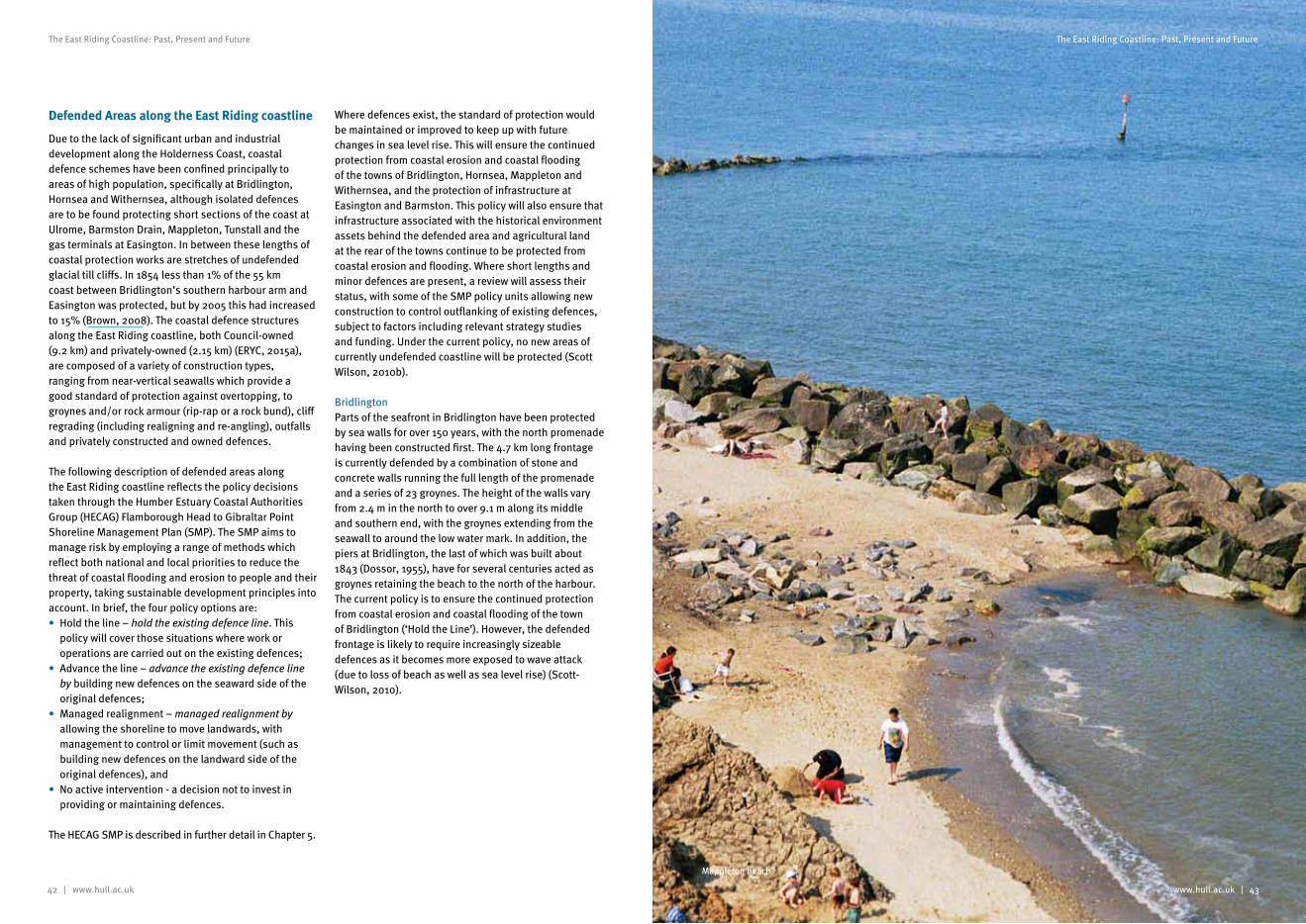
42 | www.hull.ac.uk
The East Riding Coastline: Past, Present and Future
www.hull.ac.uk | 43
The East Riding Coastline: Past, Present and Future
Defended Areas along the East Riding coastline
Due to the lack of significant urban and industrial development along the Holderness Coast, coastal defence schemes have been confined principally to areas of high population, specifically at Bridlington, Hornsea and Withernsea, although isolated defences are to be found protecting short sections of the coast at Ulrome, Barmston Drain, Mappleton, Tunstall and the gas terminals at Easington. In between these lengths of coastal protection works are stretches of undefended glacial till cliffs. In 1854 less than 1% of the 55 km coast between Bridlington’s southern harbour arm and Easington was protected, but by 2005 this had increased to 15% (Brown, 2008). The coastal defence structures along the East Riding coastline, both Council-owned (9.2 km) and privately-owned (2.15 km) (ERYC, 2015a), are composed of a variety of construction types, ranging from near-vertical seawalls which provide a good standard of protection against overtopping, to groynes and/or rock armour (rip-rap or a rock bund), cliff regrading (including realigning and re-angling), outfalls and privately constructed and owned defences.
The following description of defended areas along the East Riding coastline reflects the policy decisions taken through the Humber Estuary Coastal Authorities Group (HECAG) Flamborough Head to Gibraltar Point Shoreline Management Plan (SMP). The SMP aims to manage risk by employing a range of methods which reflect both national and local priorities to reduce the threat of coastal flooding and erosion to people and their property, taking sustainable development principles into account. In brief, the four policy options are:• Hold the line – hold the existing defence line. This
policy will cover those situations where work or operations are carried out on the existing defences;
• Advance the line – advance the existing defence line by building new defences on the seaward side of the original defences;
• Managed realignment – managed realignment by allowing the shoreline to move landwards, with management to control or limit movement (such as building new defences on the landward side of the original defences), and
• No active intervention - a decision not to invest in providing or maintaining defences.
The HECAG SMP is described in further detail in Chapter 5.
Where defences exist, the standard of protection would be maintained or improved to keep up with future changes in sea level rise. This will ensure the continued protection from coastal erosion and coastal flooding of the towns of Bridlington, Hornsea, Mappleton and Withernsea, and the protection of infrastructure at Easington and Barmston. This policy will also ensure that infrastructure associated with the historical environment assets behind the defended area and agricultural land at the rear of the towns continue to be protected from coastal erosion and flooding. Where short lengths and minor defences are present, a review will assess their status, with some of the SMP policy units allowing new construction to control outflanking of existing defences, subject to factors including relevant strategy studies and funding. Under the current policy, no new areas of currently undefended coastline will be protected (Scott Wilson, 2010b).
BridlingtonParts of the seafront in Bridlington have been protected by sea walls for over 150 years, with the north promenade having been constructed first. The 4.7 km long frontage is currently defended by a combination of stone and concrete walls running the full length of the promenade and a series of 23 groynes. The height of the walls vary from 2.4 m in the north to over 9.1 m along its middle and southern end, with the groynes extending from the seawall to around the low water mark. In addition, the piers at Bridlington, the last of which was built about 1843 (Dossor, 1955), have for several centuries acted as groynes retaining the beach to the north of the harbour. The current policy is to ensure the continued protection from coastal erosion and coastal flooding of the town of Bridlington (‘Hold the Line’). However, the defended frontage is likely to require increasingly sizeable defences as it becomes more exposed to wave attack (due to loss of beach as well as sea level rise) (Scott-Wilson, 2010).
Mappleton beach
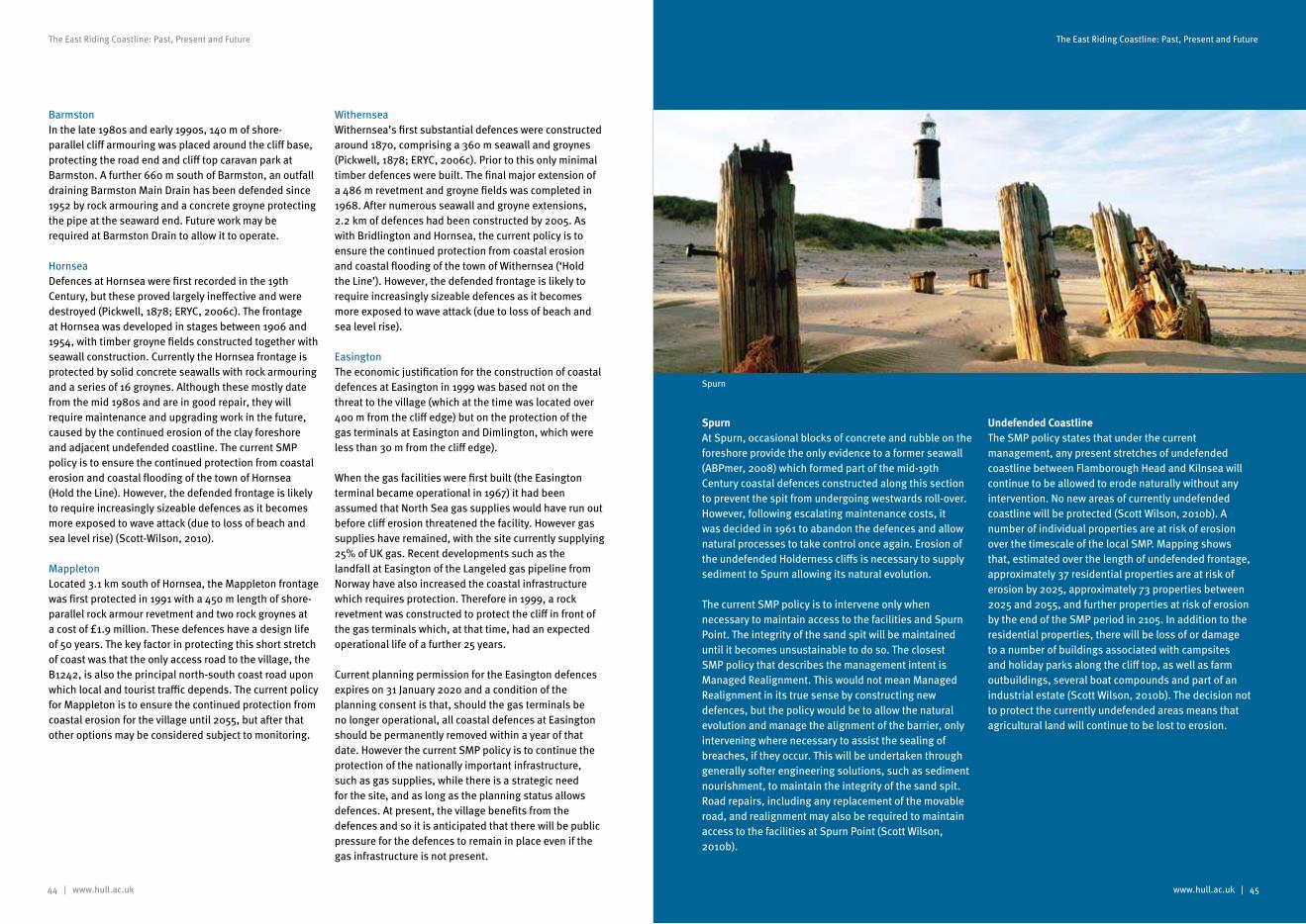
44 | www.hull.ac.uk
The East Riding Coastline: Past, Present and Future
www.hull.ac.uk | 45
The East Riding Coastline: Past, Present and Future
BarmstonIn the late 1980s and early 1990s, 140 m of shore-parallel cliff armouring was placed around the cliff base, protecting the road end and cliff top caravan park at Barmston. A further 660 m south of Barmston, an outfall draining Barmston Main Drain has been defended since 1952 by rock armouring and a concrete groyne protecting the pipe at the seaward end. Future work may be required at Barmston Drain to allow it to operate.
HornseaDefences at Hornsea were first recorded in the 19th Century, but these proved largely ineffective and were destroyed (Pickwell, 1878; ERYC, 2006c). The frontage at Hornsea was developed in stages between 1906 and 1954, with timber groyne fields constructed together with seawall construction. Currently the Hornsea frontage is protected by solid concrete seawalls with rock armouring and a series of 16 groynes. Although these mostly date from the mid 1980s and are in good repair, they will require maintenance and upgrading work in the future, caused by the continued erosion of the clay foreshore and adjacent undefended coastline. The current SMP policy is to ensure the continued protection from coastal erosion and coastal flooding of the town of Hornsea (Hold the Line). However, the defended frontage is likely to require increasingly sizeable defences as it becomes more exposed to wave attack (due to loss of beach and sea level rise) (Scott-Wilson, 2010).
MappletonLocated 3.1 km south of Hornsea, the Mappleton frontage was first protected in 1991 with a 450 m length of shore-parallel rock armour revetment and two rock groynes at a cost of £1.9 million. These defences have a design life of 50 years. The key factor in protecting this short stretch of coast was that the only access road to the village, the B1242, is also the principal north-south coast road upon which local and tourist traffic depends. The current policy for Mappleton is to ensure the continued protection from coastal erosion for the village until 2055, but after that other options may be considered subject to monitoring.
WithernseaWithernsea’s first substantial defences were constructed around 1870, comprising a 360 m seawall and groynes (Pickwell, 1878; ERYC, 2006c). Prior to this only minimal timber defences were built. The final major extension of a 486 m revetment and groyne fields was completed in 1968. After numerous seawall and groyne extensions, 2.2 km of defences had been constructed by 2005. As with Bridlington and Hornsea, the current policy is to ensure the continued protection from coastal erosion and coastal flooding of the town of Withernsea (‘Hold the Line’). However, the defended frontage is likely to require increasingly sizeable defences as it becomes more exposed to wave attack (due to loss of beach and sea level rise).
EasingtonThe economic justification for the construction of coastal defences at Easington in 1999 was based not on the threat to the village (which at the time was located over 400 m from the cliff edge) but on the protection of the gas terminals at Easington and Dimlington, which were less than 30 m from the cliff edge).
When the gas facilities were first built (the Easington terminal became operational in 1967) it had been assumed that North Sea gas supplies would have run out before cliff erosion threatened the facility. However gas supplies have remained, with the site currently supplying 25% of UK gas. Recent developments such as the landfall at Easington of the Langeled gas pipeline from Norway have also increased the coastal infrastructure which requires protection. Therefore in 1999, a rock revetment was constructed to protect the cliff in front of the gas terminals which, at that time, had an expected operational life of a further 25 years.
Current planning permission for the Easington defences expires on 31 January 2020 and a condition of the planning consent is that, should the gas terminals be no longer operational, all coastal defences at Easington should be permanently removed within a year of that date. However the current SMP policy is to continue the protection of the nationally important infrastructure, such as gas supplies, while there is a strategic need for the site, and as long as the planning status allows defences. At present, the village benefits from the defences and so it is anticipated that there will be public pressure for the defences to remain in place even if the gas infrastructure is not present.Spurn
SpurnAt Spurn, occasional blocks of concrete and rubble on the foreshore provide the only evidence to a former seawall (ABPmer, 2008) which formed part of the mid-19th Century coastal defences constructed along this section to prevent the spit from undergoing westwards roll-over. However, following escalating maintenance costs, it was decided in 1961 to abandon the defences and allow natural processes to take control once again. Erosion of the undefended Holderness cliffs is necessary to supply sediment to Spurn allowing its natural evolution.
The current SMP policy is to intervene only when necessary to maintain access to the facilities and Spurn Point. The integrity of the sand spit will be maintained until it becomes unsustainable to do so. The closest SMP policy that describes the management intent is Managed Realignment. This would not mean Managed Realignment in its true sense by constructing new defences, but the policy would be to allow the natural evolution and manage the alignment of the barrier, only intervening where necessary to assist the sealing of breaches, if they occur. This will be undertaken through generally softer engineering solutions, such as sediment nourishment, to maintain the integrity of the sand spit. Road repairs, including any replacement of the movable road, and realignment may also be required to maintain access to the facilities at Spurn Point (Scott Wilson, 2010b).
Undefended CoastlineThe SMP policy states that under the current management, any present stretches of undefended coastline between Flamborough Head and Kilnsea will continue to be allowed to erode naturally without any intervention. No new areas of currently undefended coastline will be protected (Scott Wilson, 2010b). A number of individual properties are at risk of erosion over the timescale of the local SMP. Mapping shows that, estimated over the length of undefended frontage, approximately 37 residential properties are at risk of erosion by 2025, approximately 73 properties between 2025 and 2055, and further properties at risk of erosion by the end of the SMP period in 2105. In addition to the residential properties, there will be loss of or damage to a number of buildings associated with campsites and holiday parks along the cliff top, as well as farm outbuildings, several boat compounds and part of an industrial estate (Scott Wilson, 2010b). The decision not to protect the currently undefended areas means that agricultural land will continue to be lost to erosion.
Spurn
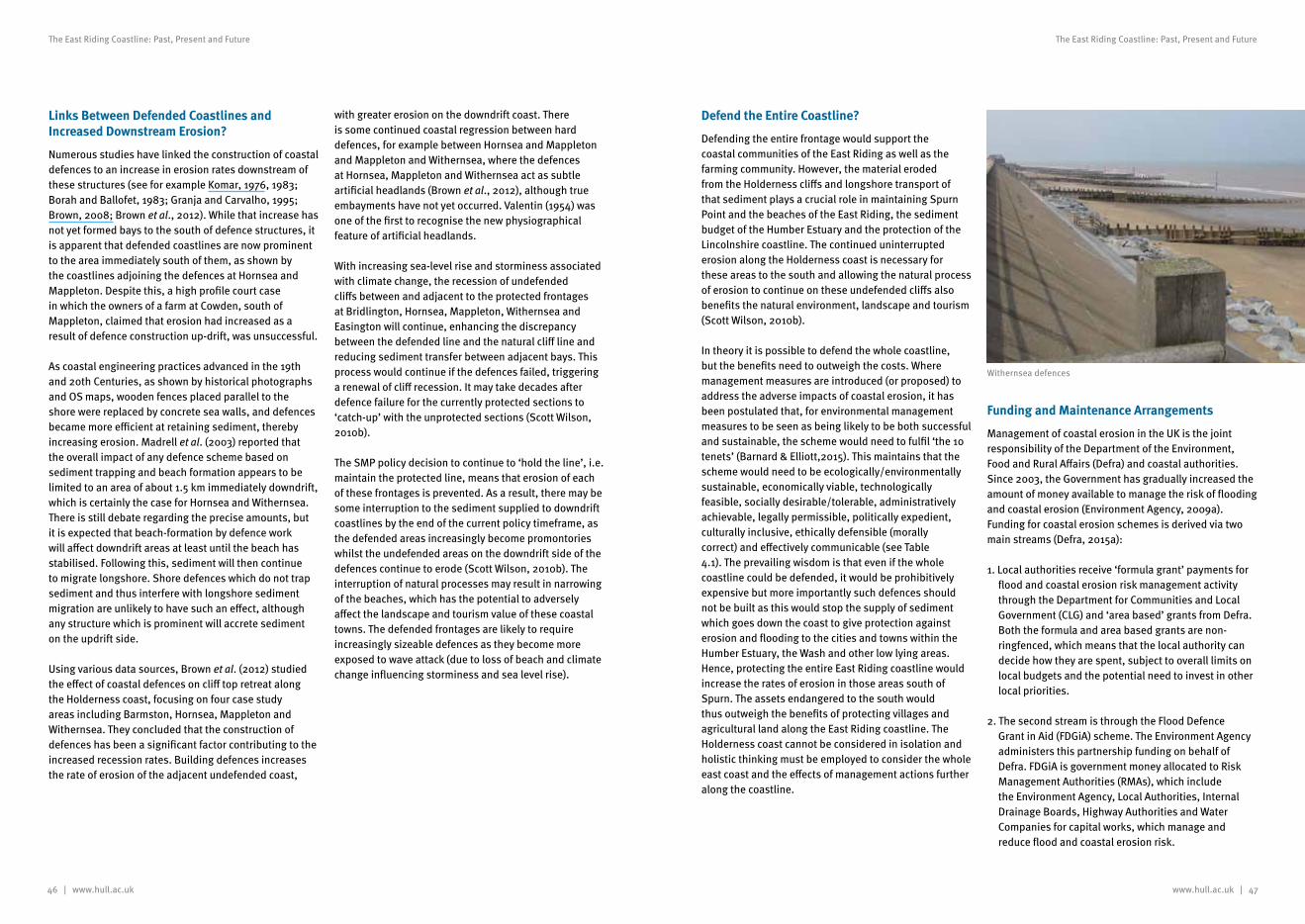
46 | www.hull.ac.uk www.hull.ac.uk | 47
The East Riding Coastline: Past, Present and Future The East Riding Coastline: Past, Present and Future
Links Between Defended Coastlines and Increased Downstream Erosion?
Numerous studies have linked the construction of coastal defences to an increase in erosion rates downstream of these structures (see for example Komar, 1976, 1983; Borah and Ballofet, 1983; Granja and Carvalho, 1995; Brown, 2008; Brown et al., 2012). While that increase has not yet formed bays to the south of defence structures, it is apparent that defended coastlines are now prominent to the area immediately south of them, as shown by the coastlines adjoining the defences at Hornsea and Mappleton. Despite this, a high profile court case in which the owners of a farm at Cowden, south of Mappleton, claimed that erosion had increased as a result of defence construction up-drift, was unsuccessful.
As coastal engineering practices advanced in the 19th and 20th Centuries, as shown by historical photographs and OS maps, wooden fences placed parallel to the shore were replaced by concrete sea walls, and defences became more efficient at retaining sediment, thereby increasing erosion. Madrell et al. (2003) reported that the overall impact of any defence scheme based on sediment trapping and beach formation appears to be limited to an area of about 1.5 km immediately downdrift, which is certainly the case for Hornsea and Withernsea. There is still debate regarding the precise amounts, but it is expected that beach-formation by defence work will affect downdrift areas at least until the beach has stabilised. Following this, sediment will then continue to migrate longshore. Shore defences which do not trap sediment and thus interfere with longshore sediment migration are unlikely to have such an effect, although any structure which is prominent will accrete sediment on the updrift side.
Using various data sources, Brown et al. (2012) studied the effect of coastal defences on cliff top retreat along the Holderness coast, focusing on four case study areas including Barmston, Hornsea, Mappleton and Withernsea. They concluded that the construction of defences has been a significant factor contributing to the increased recession rates. Building defences increases the rate of erosion of the adjacent undefended coast,
with greater erosion on the downdrift coast. There is some continued coastal regression between hard defences, for example between Hornsea and Mappleton and Mappleton and Withernsea, where the defences at Hornsea, Mappleton and Withernsea act as subtle artificial headlands (Brown et al., 2012), although true embayments have not yet occurred. Valentin (1954) was one of the first to recognise the new physiographical feature of artificial headlands.
With increasing sea-level rise and storminess associated with climate change, the recession of undefended cliffs between and adjacent to the protected frontages at Bridlington, Hornsea, Mappleton, Withernsea and Easington will continue, enhancing the discrepancy between the defended line and the natural cliff line and reducing sediment transfer between adjacent bays. This process would continue if the defences failed, triggering a renewal of cliff recession. It may take decades after defence failure for the currently protected sections to ‘catch-up’ with the unprotected sections (Scott Wilson, 2010b).
The SMP policy decision to continue to ‘hold the line’, i.e. maintain the protected line, means that erosion of each of these frontages is prevented. As a result, there may be some interruption to the sediment supplied to downdrift coastlines by the end of the current policy timeframe, as the defended areas increasingly become promontories whilst the undefended areas on the downdrift side of the defences continue to erode (Scott Wilson, 2010b). The interruption of natural processes may result in narrowing of the beaches, which has the potential to adversely affect the landscape and tourism value of these coastal towns. The defended frontages are likely to require increasingly sizeable defences as they become more exposed to wave attack (due to loss of beach and climate change influencing storminess and sea level rise).
Defend the Entire Coastline?
Defending the entire frontage would support the coastal communities of the East Riding as well as the farming community. However, the material eroded from the Holderness cliffs and longshore transport of that sediment plays a crucial role in maintaining Spurn Point and the beaches of the East Riding, the sediment budget of the Humber Estuary and the protection of the Lincolnshire coastline. The continued uninterrupted erosion along the Holderness coast is necessary for these areas to the south and allowing the natural process of erosion to continue on these undefended cliffs also benefits the natural environment, landscape and tourism (Scott Wilson, 2010b).
In theory it is possible to defend the whole coastline, but the benefits need to outweigh the costs. Where management measures are introduced (or proposed) to address the adverse impacts of coastal erosion, it has been postulated that, for environmental management measures to be seen as being likely to be both successful and sustainable, the scheme would need to fulfil ‘the 10 tenets’ (Barnard & Elliott,2015). This maintains that the scheme would need to be ecologically/environmentally sustainable, economically viable, technologically feasible, socially desirable/tolerable, administratively achievable, legally permissible, politically expedient, culturally inclusive, ethically defensible (morally correct) and effectively communicable (see Table 4.1). The prevailing wisdom is that even if the whole coastline could be defended, it would be prohibitively expensive but more importantly such defences should not be built as this would stop the supply of sediment which goes down the coast to give protection against erosion and flooding to the cities and towns within the Humber Estuary, the Wash and other low lying areas. Hence, protecting the entire East Riding coastline would increase the rates of erosion in those areas south of Spurn. The assets endangered to the south would thus outweigh the benefits of protecting villages and agricultural land along the East Riding coastline. The Holderness coast cannot be considered in isolation and holistic thinking must be employed to consider the whole east coast and the effects of management actions further along the coastline.
Funding and Maintenance Arrangements
Management of coastal erosion in the UK is the joint responsibility of the Department of the Environment, Food and Rural Affairs (Defra) and coastal authorities. Since 2003, the Government has gradually increased the amount of money available to manage the risk of flooding and coastal erosion (Environment Agency, 2009a). Funding for coastal erosion schemes is derived via two main streams (Defra, 2015a):
1. Local authorities receive ‘formula grant’ payments for flood and coastal erosion risk management activity through the Department for Communities and Local Government (CLG) and ‘area based’ grants from Defra. Both the formula and area based grants are non-ringfenced, which means that the local authority can decide how they are spent, subject to overall limits on local budgets and the potential need to invest in other local priorities.
2. The second stream is through the Flood Defence Grant in Aid (FDGiA) scheme. The Environment Agency administers this partnership funding on behalf of Defra. FDGiA is government money allocated to Risk Management Authorities (RMAs), which include the Environment Agency, Local Authorities, Internal Drainage Boards, Highway Authorities and Water Companies for capital works, which manage and reduce flood and coastal erosion risk.
Withernsea defences
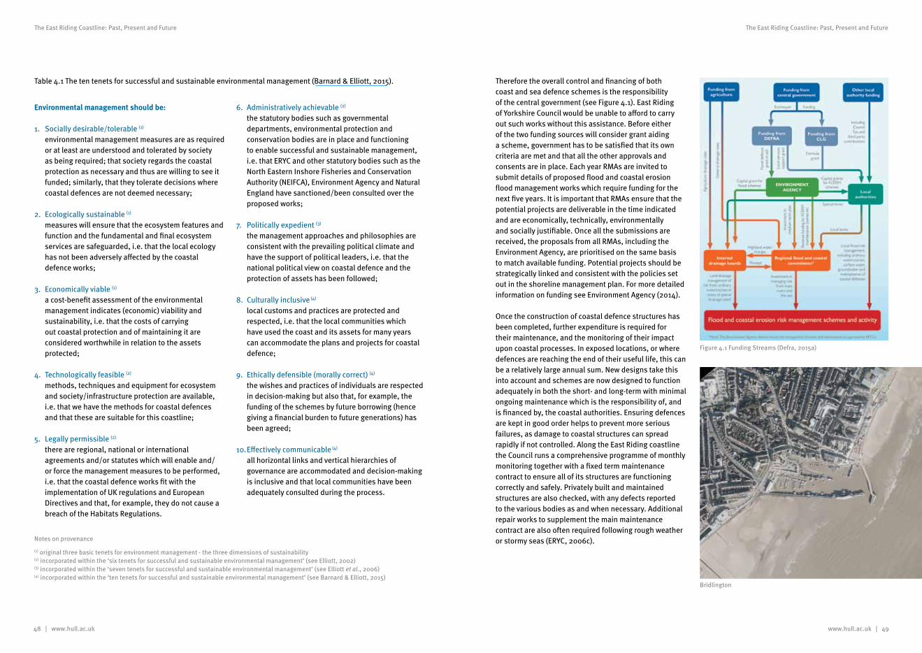
48 | www.hull.ac.uk www.hull.ac.uk | 49
The East Riding Coastline: Past, Present and Future The East Riding Coastline: Past, Present and Future
Environmental management should be:
1. Socially desirable/tolerable (1) environmental management measures are as required or at least are understood and tolerated by society as being required; that society regards the coastal protection as necessary and thus are willing to see it funded; similarly, that they tolerate decisions where coastal defences are not deemed necessary;
2. Ecologically sustainable (1) measures will ensure that the ecosystem features and function and the fundamental and final ecosystem services are safeguarded, i.e. that the local ecology has not been adversely affected by the coastal defence works;
3. Economically viable (1) a cost-benefit assessment of the environmental management indicates (economic) viability and sustainability, i.e. that the costs of carrying out coastal protection and of maintaining it are considered worthwhile in relation to the assets protected;
4. Technologically feasible (2) methods, techniques and equipment for ecosystem and society/infrastructure protection are available, i.e. that we have the methods for coastal defences and that these are suitable for this coastline;
5. Legally permissible (2) there are regional, national or international agreements and/or statutes which will enable and/or force the management measures to be performed, i.e. that the coastal defence works fit with the implementation of UK regulations and European Directives and that, for example, they do not cause a breach of the Habitats Regulations.
6. Administratively achievable (2) the statutory bodies such as governmental departments, environmental protection and conservation bodies are in place and functioning to enable successful and sustainable management, i.e. that ERYC and other statutory bodies such as the North Eastern Inshore Fisheries and Conservation Authority (NEIFCA), Environment Agency and Natural England have sanctioned/been consulted over the proposed works;
7. Politically expedient (3) the management approaches and philosophies are consistent with the prevailing political climate and have the support of political leaders, i.e. that the national political view on coastal defence and the protection of assets has been followed;
8. Culturally inclusive (4) local customs and practices are protected and respected, i.e. that the local communities which have used the coast and its assets for many years can accommodate the plans and projects for coastal defence;
9. Ethically defensible (morally correct) (4) the wishes and practices of individuals are respected in decision-making but also that, for example, the funding of the schemes by future borrowing (hence giving a financial burden to future generations) has been agreed;
10. Effectively communicable (4) all horizontal links and vertical hierarchies of governance are accommodated and decision-making is inclusive and that local communities have been adequately consulted during the process.
Therefore the overall control and financing of both coast and sea defence schemes is the responsibility of the central government (see Figure 4.1). East Riding of Yorkshire Council would be unable to afford to carry out such works without this assistance. Before either of the two funding sources will consider grant aiding a scheme, government has to be satisfied that its own criteria are met and that all the other approvals and consents are in place. Each year RMAs are invited to submit details of proposed flood and coastal erosion flood management works which require funding for the next five years. It is important that RMAs ensure that the potential projects are deliverable in the time indicated and are economically, technically, environmentally and socially justifiable. Once all the submissions are received, the proposals from all RMAs, including the Environment Agency, are prioritised on the same basis to match available funding. Potential projects should be strategically linked and consistent with the policies set out in the shoreline management plan. For more detailed information on funding see Environment Agency (2014).
Once the construction of coastal defence structures has been completed, further expenditure is required for their maintenance, and the monitoring of their impact upon coastal processes. In exposed locations, or where defences are reaching the end of their useful life, this can be a relatively large annual sum. New designs take this into account and schemes are now designed to function adequately in both the short- and long-term with minimal ongoing maintenance which is the responsibility of, and is financed by, the coastal authorities. Ensuring defences are kept in good order helps to prevent more serious failures, as damage to coastal structures can spread rapidly if not controlled. Along the East Riding coastline the Council runs a comprehensive programme of monthly monitoring together with a fixed term maintenance contract to ensure all of its structures are functioning correctly and safely. Privately built and maintained structures are also checked, with any defects reported to the various bodies as and when necessary. Additional repair works to supplement the main maintenance contract are also often required following rough weather or stormy seas (ERYC, 2006c).
Table 4.1 The ten tenets for successful and sustainable environmental management (Barnard & Elliott, 2015).
Notes on provenance
(1) original three basic tenets for environment management - the three dimensions of sustainability (2) incorporated within the ‘six tenets for successful and sustainable environmental management’ (see Elliott, 2002) (3) incorporated within the ‘seven tenets for successful and sustainable environmental management’ (see Elliott et al., 2006) (4) incorporated within the ‘ten tenets for successful and sustainable environmental management’ (see Barnard & Elliott, 2015)
Figure 4.1 Funding Streams (Defra, 2015a)
Bridlington
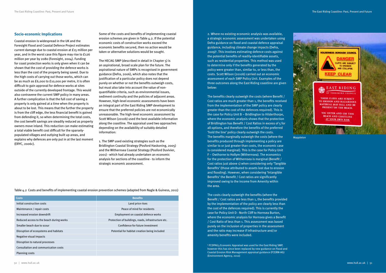
50 | www.hull.ac.uk
The East Riding Coastline: Past, Present and Future
www.hull.ac.uk | 51
The East Riding Coastline: Past, Present and Future
Socio-economic Implications
Coastal erosion is widespread in the UK and the Foresight Flood and Coastal Defence Project estimates current damage due to coastal erosion at £15 million per year, and in the worst case this figure may rise to £126 million per year by 2080 (Foresight, 2004). Funding for coast protection works is only given when it can be shown that the cost of providing the defence works is less than the cost of the property being saved. Due to the high costs of carrying out those works, which can be as much as £6,000 to £10,000 per metre, it is often difficult to gain approval for defence works at sites outside of the currently developed frontage. This would also contravene the current SMP policy in many areas. A further complication is that the full cost of saving a property is only gained at a time when the property is about to be lost. This means that the further the property is from the cliff edge, the less financial benefit is gained from defending it, so when determining the total costs, the cost benefit savings are steadily reduced as property owners move inland. This reduction can make estimating a total viable benefit cost difficult for the sparsely-populated villages and outlying built up areas, and explains why defences are only put in at the last moment (ERYC, 2006c).
Some of the costs and benefits of implementing coastal erosion schemes are given in Table 4.2. If the potential economic costs of construction works exceed the economic benefits secured, then no action would be taken or alternative solutions would be sought.
The HECAG SMP (described in detail in Chapter 5) is an aspirational, broad scale plan for the future. The aspirational nature of SMPs is recognised in government guidance (Defra, 2006), which also notes that the justification of a particular policy does not depend purely on whether or not the benefits outweigh costs, but must also take into account the value of non-quantifiable criteria, such as environmental issues, sediment continuity and the policies of adjacent areas. However, high-level economic assessments have been an integral part of the East Riding SMP development to ensure that the preferred policies are not economically unreasonable. The high-level economic assessment by Scott Wilson (2010b) used the best available information along the coastline. The appraisal used two approaches depending on the availability of suitably detailed information:
1. The SMP used existing strategies such as the Bridlington Coastal Strategy (Posford Haskoning, 2005) and the Withernsea Coastal Strategy (Posford Duvivier, 2001) - which had already undertaken an economic analysis for sections of the coastline - to inform the strategic economic assessment.
2. Where no existing economic analysis was available, a strategic economic assessment was undertaken using Defra guidance on flood and coastal defence appraisal guidance, including climate change impacts (Defra, 2009)5. This involves estimating defence costs against the potential benefits of readily-identifiable assets, such as residential properties. This method was used to determine only if the benefits generated by the policy were greater than, similar to, or less than, the costs. Scott Wilson (2010b) carried out an economic assessment of each SMP Policy Unit. Examples of the three outcomes along the East Riding coastline are given below:
The benefits clearly outweigh the costs (where Benefit / Cost ratios are much greater than 1, the benefits received from the implementation of the SMP policy are clearly greater than the cost of the defences required). This is the case for Policy Unit B – Bridlington to Hilderthorpe, where the economic analysis shows that the protection of Bridlington has Benefit / Cost Ratios in excess of 5 for all options, and therefore the benefits of the preferred ‘hold the line’ policy clearly outweigh the costs.The benefits marginally outweigh the costs (where the benefits produced through implementing a policy are similar to or just greater than costs, the economic case is considered marginal). This is the case for Policy Unit F – Owthorne to Hollym (Withernsea). The economics for the protection of Withernsea is marginal (Benefit / Cost ratios just above 1) when considering only ‘Tangible Benefits’ (those attributed to assets lost due to erosion and flooding). However, when considering ‘Intangible Benefits’ the Benefit / Cost ratios are significantly improved owing to the income from Amenity within the area.
The costs clearly outweigh the benefits (where the Benefit / Cost ratios are less than 1, the benefits provided by the implementation of the policy are clearly less than the cost of the defences required). This is currently the case for Policy Unit D - North Cliff to Hornsea Burton, where the economic analysis for Hornsea gives a Benefit / Cost Ratio of less than 1. This assessment was based purely on the inclusion of properties in the assessment and the ratio may increase if infrastructure and/or amenity benefits were included.
Costs Benefits
Initial construction costs Land price rises
Maintenance / repair costs Peace of mind for residents
Increased erosion downdrift Employment on coastal defence works
Reduced access to the beach during works Protection of buildings, roads, infrastructure etc.
Smaller beach due to scour Confidence for future investment
Disruption of ecosystems and habitats Potential for habitat creation being included
Negative visual impacts
Disruption to natural processes
Consultation and communication costs
Planning costs
Table 4.2 Costs and benefits of implementing coastal erosion prevention schemes (adapted from Nagle & Guiness, 2011)
5 FCDPAG3 Economic Appraisal was used for the East Riding SMP, however this has since been replaced by new guidance on Flood and Coastal Erosion Risk Management appraisal guidance (FCERM-AG) (Environment Agency, 2010)
Mappleton
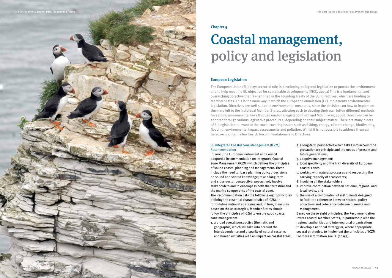
www.hull.ac.uk | 53
The East Riding Coastline: Past, Present and Future
52 | www.hull.ac.uk
The East Riding Coastline: Past, Present and Future
Chapter 5
Coastal management, policy and legislationEuropean Legislation
The European Union (EU) plays a crucial role in developing policy and legislation to protect the environment and to help meet the EU objective for sustainable development. (JNCC, 2015a) This is a fundamental and overarching objective that is enshrined in the Founding Treaty of the EU. Directives, which are binding to Member States. This is the main way in which the European Commission (EC) implements environmental legislation. Directives are well-suited to environmental measures, since the decisions on how to implement them are left to the individual Member States, allowing each to develop their own (often different) methods for setting environmental laws through enabling legislation (Bell and McGillivray, 2000). Directives can be adopted through various legislative procedures, depending on their subject matter. There are many pieces of EU legislation relevant to the coast, covering issues such as fishing, energy, climate change, biodiversity, flooding, environmental impact assessments and pollution. Whilst it is not possible to address them all here, we highlight a few key EU Recommendations and Directives.
EU Integrated Coastal Zone Management (ICZM) RecommendationIn 2002, the European Parliament and Council adopted a Recommendation on Integrated Coastal Zone Management (ICZM) which defines the principles of sound coastal planning and management. These include the need to: base planning policy / decisions on sound and shared knowledge; take a long-term and cross-sector perspective; pro-actively involve stakeholders and to encompass both the terrestrial and the marine components of the coastal zone.The Recommendation lists the following eight principles defining the essential characteristics of ICZM. In formulating national strategies and, in turn, measures based on these strategies, Member States should follow the principles of ICZM to ensure good coastal zone management:1. a broad overall perspective (thematic and
geographic) which will take into account the interdependence and disparity of natural systems and human activities with an impact on coastal areas;
2. a long-term perspective which takes into account the precautionary principle and the needs of present and future generations;
3. adaptive management;4. local specificity and the high diversity of European
coastal zones;5. working with natural processes and respecting the
carrying capacity of ecosystems;6. involving all the stakeholders;7. improve coordination between national, regional and
local levels, and8. the use of a combination of instruments designed
to facilitate coherence between sectoral policy objectives and coherence between planning and management.
Based on these eight principles, the Recommendation invites coastal Member States, in partnership with the regional authorities and inter-regional organisations, to develop a national strategy or, where appropriate, several strategies, to implement the principles of ICZM. For more information see EC (2015a).
Puffins (Fratercula arctica) at Bempton cliff
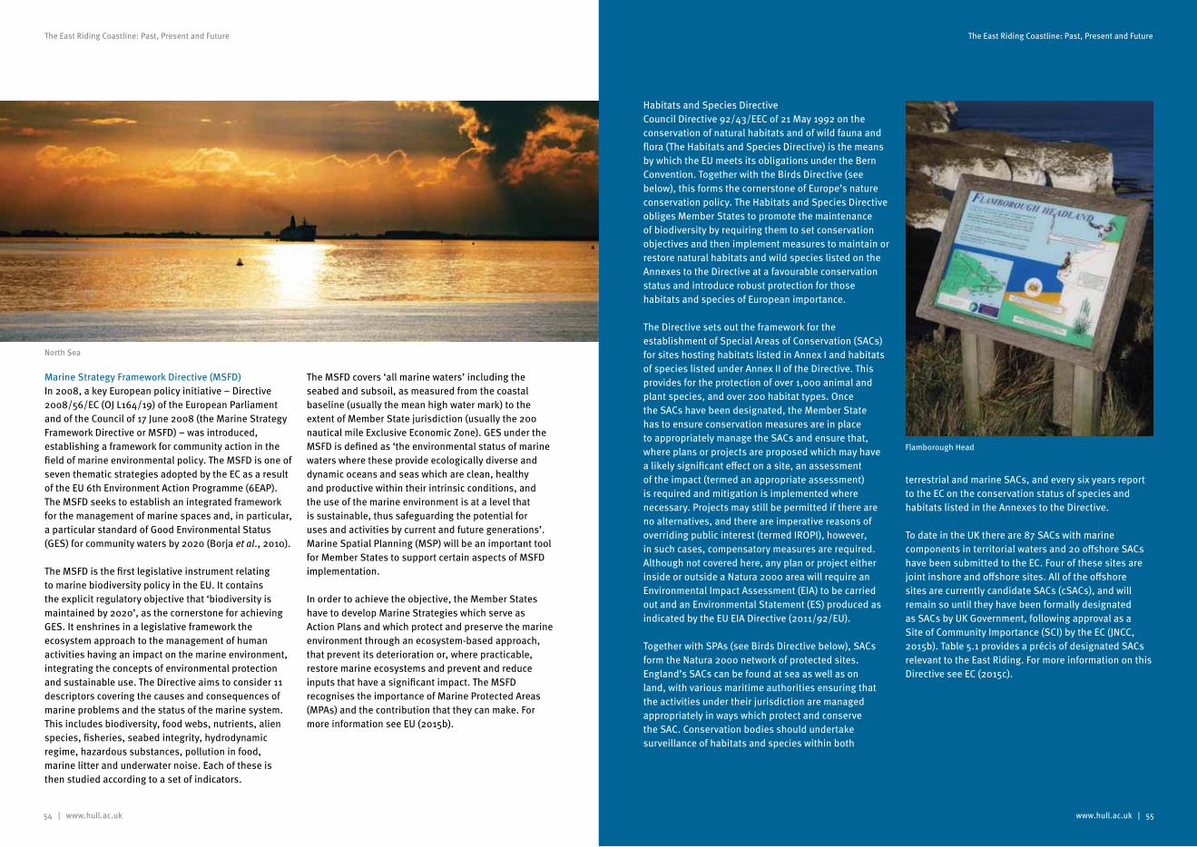
54 | www.hull.ac.uk
The East Riding Coastline: Past, Present and Future
www.hull.ac.uk | 55
The East Riding Coastline: Past, Present and Future
Marine Strategy Framework Directive (MSFD)In 2008, a key European policy initiative – Directive 2008/56/EC (OJ L164/19) of the European Parliament and of the Council of 17 June 2008 (the Marine Strategy Framework Directive or MSFD) – was introduced, establishing a framework for community action in the field of marine environmental policy. The MSFD is one of seven thematic strategies adopted by the EC as a result of the EU 6th Environment Action Programme (6EAP). The MSFD seeks to establish an integrated framework for the management of marine spaces and, in particular, a particular standard of Good Environmental Status (GES) for community waters by 2020 (Borja et al., 2010).
The MSFD is the first legislative instrument relating to marine biodiversity policy in the EU. It contains the explicit regulatory objective that ‘biodiversity is maintained by 2020’, as the cornerstone for achieving GES. It enshrines in a legislative framework the ecosystem approach to the management of human activities having an impact on the marine environment, integrating the concepts of environmental protection and sustainable use. The Directive aims to consider 11 descriptors covering the causes and consequences of marine problems and the status of the marine system. This includes biodiversity, food webs, nutrients, alien species, fisheries, seabed integrity, hydrodynamic regime, hazardous substances, pollution in food, marine litter and underwater noise. Each of these is then studied according to a set of indicators.
The MSFD covers ‘all marine waters’ including the seabed and subsoil, as measured from the coastal baseline (usually the mean high water mark) to the extent of Member State jurisdiction (usually the 200 nautical mile Exclusive Economic Zone). GES under the MSFD is defined as ‘the environmental status of marine waters where these provide ecologically diverse and dynamic oceans and seas which are clean, healthy and productive within their intrinsic conditions, and the use of the marine environment is at a level that is sustainable, thus safeguarding the potential for uses and activities by current and future generations’. Marine Spatial Planning (MSP) will be an important tool for Member States to support certain aspects of MSFD implementation.
In order to achieve the objective, the Member States have to develop Marine Strategies which serve as Action Plans and which protect and preserve the marine environment through an ecosystem-based approach, that prevent its deterioration or, where practicable, restore marine ecosystems and prevent and reduce inputs that have a significant impact. The MSFD recognises the importance of Marine Protected Areas (MPAs) and the contribution that they can make. For more information see EU (2015b).
Habitats and Species DirectiveCouncil Directive 92/43/EEC of 21 May 1992 on the conservation of natural habitats and of wild fauna and flora (The Habitats and Species Directive) is the means by which the EU meets its obligations under the Bern Convention. Together with the Birds Directive (see below), this forms the cornerstone of Europe’s nature conservation policy. The Habitats and Species Directive obliges Member States to promote the maintenance of biodiversity by requiring them to set conservation objectives and then implement measures to maintain or restore natural habitats and wild species listed on the Annexes to the Directive at a favourable conservation status and introduce robust protection for those habitats and species of European importance.
The Directive sets out the framework for the establishment of Special Areas of Conservation (SACs) for sites hosting habitats listed in Annex I and habitats of species listed under Annex II of the Directive. This provides for the protection of over 1,000 animal and plant species, and over 200 habitat types. Once the SACs have been designated, the Member State has to ensure conservation measures are in place to appropriately manage the SACs and ensure that, where plans or projects are proposed which may have a likely significant effect on a site, an assessment of the impact (termed an appropriate assessment) is required and mitigation is implemented where necessary. Projects may still be permitted if there are no alternatives, and there are imperative reasons of overriding public interest (termed IROPI), however, in such cases, compensatory measures are required. Although not covered here, any plan or project either inside or outside a Natura 2000 area will require an Environmental Impact Assessment (EIA) to be carried out and an Environmental Statement (ES) produced as indicated by the EU EIA Directive (2011/92/EU).
Together with SPAs (see Birds Directive below), SACs form the Natura 2000 network of protected sites. England’s SACs can be found at sea as well as on land, with various maritime authorities ensuring that the activities under their jurisdiction are managed appropriately in ways which protect and conserve the SAC. Conservation bodies should undertake surveillance of habitats and species within both
terrestrial and marine SACs, and every six years report to the EC on the conservation status of species and habitats listed in the Annexes to the Directive.
To date in the UK there are 87 SACs with marine components in territorial waters and 20 offshore SACs have been submitted to the EC. Four of these sites are joint inshore and offshore sites. All of the offshore sites are currently candidate SACs (cSACs), and will remain so until they have been formally designated as SACs by UK Government, following approval as a Site of Community Importance (SCI) by the EC (JNCC, 2015b). Table 5.1 provides a précis of designated SACs relevant to the East Riding. For more information on this Directive see EC (2015c).
Flamborough Head
North Sea
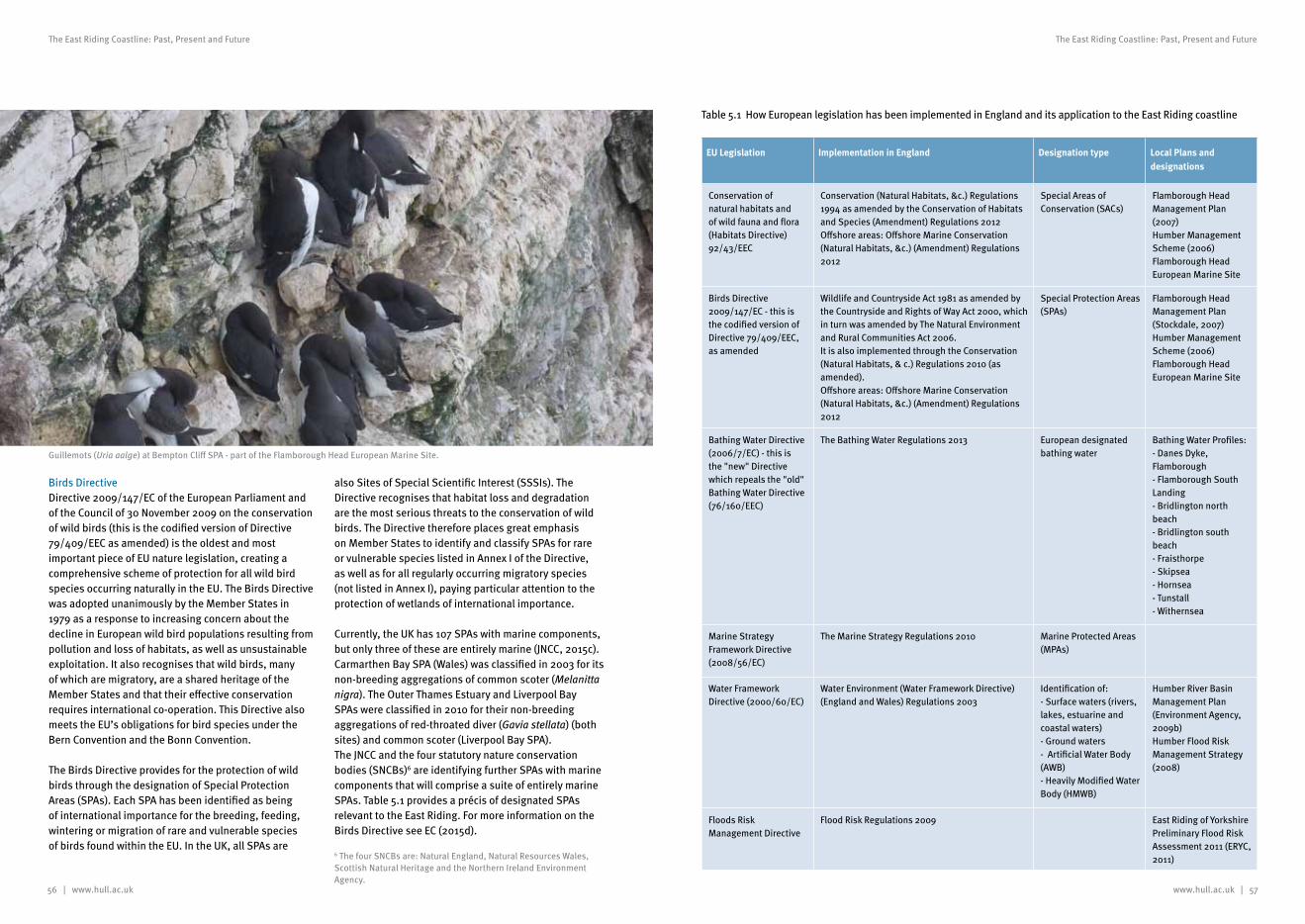
56 | www.hull.ac.uk
The East Riding Coastline: Past, Present and Future
www.hull.ac.uk | 57
The East Riding Coastline: Past, Present and Future
6 The four SNCBs are: Natural England, Natural Resources Wales, Scottish Natural Heritage and the Northern Ireland Environment Agency.
EU Legislation Implementation in England Designation type Local Plans and designations
Conservation of natural habitats and of wild fauna and flora (Habitats Directive) 92/43/EEC
Conservation (Natural Habitats, &c.) Regulations 1994 as amended by the Conservation of Habitats and Species (Amendment) Regulations 2012Offshore areas: Offshore Marine Conservation (Natural Habitats, &c.) (Amendment) Regulations 2012
Special Areas of Conservation (SACs)
Flamborough Head Management Plan (2007)Humber Management Scheme (2006)Flamborough Head European Marine Site
Birds Directive 2009/147/EC - this is the codified version of Directive 79/409/EEC, as amended
Wildlife and Countryside Act 1981 as amended by the Countryside and Rights of Way Act 2000, which in turn was amended by The Natural Environment and Rural Communities Act 2006. It is also implemented through the Conservation (Natural Habitats, & c.) Regulations 2010 (as amended).Offshore areas: Offshore Marine Conservation (Natural Habitats, &c.) (Amendment) Regulations 2012
Special Protection Areas (SPAs)
Flamborough Head Management Plan (Stockdale, 2007)Humber Management Scheme (2006)Flamborough Head European Marine Site
Bathing Water Directive (2006/7/EC) - this is the "new" Directive which repeals the "old" Bathing Water Directive (76/160/EEC)
The Bathing Water Regulations 2013 European designated bathing water
Bathing Water Profiles: - Danes Dyke, Flamborough- Flamborough South Landing- Bridlington north beach- Bridlington south beach- Fraisthorpe- Skipsea- Hornsea- Tunstall- Withernsea
Marine Strategy Framework Directive (2008/56/EC)
The Marine Strategy Regulations 2010 Marine Protected Areas (MPAs)
Water Framework Directive (2000/60/EC)
Water Environment (Water Framework Directive) (England and Wales) Regulations 2003
Identification of:- Surface waters (rivers, lakes, estuarine and coastal waters)- Ground waters- Artificial Water Body (AWB)- Heavily Modified Water Body (HMWB)
Humber River Basin Management Plan (Environment Agency, 2009b)Humber Flood Risk Management Strategy (2008)
Floods Risk Management Directive
Flood Risk Regulations 2009 East Riding of Yorkshire Preliminary Flood Risk Assessment 2011 (ERYC, 2011)
Birds Directive Directive 2009/147/EC of the European Parliament and of the Council of 30 November 2009 on the conservation of wild birds (this is the codified version of Directive 79/409/EEC as amended) is the oldest and most important piece of EU nature legislation, creating a comprehensive scheme of protection for all wild bird species occurring naturally in the EU. The Birds Directive was adopted unanimously by the Member States in 1979 as a response to increasing concern about the decline in European wild bird populations resulting from pollution and loss of habitats, as well as unsustainable exploitation. It also recognises that wild birds, many of which are migratory, are a shared heritage of the Member States and that their effective conservation requires international co-operation. This Directive also meets the EU’s obligations for bird species under the Bern Convention and the Bonn Convention.
The Birds Directive provides for the protection of wild birds through the designation of Special Protection Areas (SPAs). Each SPA has been identified as being of international importance for the breeding, feeding, wintering or migration of rare and vulnerable species of birds found within the EU. In the UK, all SPAs are
also Sites of Special Scientific Interest (SSSIs). The Directive recognises that habitat loss and degradation are the most serious threats to the conservation of wild birds. The Directive therefore places great emphasis on Member States to identify and classify SPAs for rare or vulnerable species listed in Annex I of the Directive, as well as for all regularly occurring migratory species (not listed in Annex I), paying particular attention to the protection of wetlands of international importance.
Currently, the UK has 107 SPAs with marine components, but only three of these are entirely marine (JNCC, 2015c). Carmarthen Bay SPA (Wales) was classified in 2003 for its non-breeding aggregations of common scoter (Melanitta nigra). The Outer Thames Estuary and Liverpool Bay SPAs were classified in 2010 for their non-breeding aggregations of red-throated diver (Gavia stellata) (both sites) and common scoter (Liverpool Bay SPA).The JNCC and the four statutory nature conservation bodies (SNCBs)6 are identifying further SPAs with marine components that will comprise a suite of entirely marine SPAs. Table 5.1 provides a précis of designated SPAs relevant to the East Riding. For more information on the Birds Directive see EC (2015d).
Table 5.1 How European legislation has been implemented in England and its application to the East Riding coastline
Guillemots (Uria aalge) at Bempton Cliff SPA - part of the Flamborough Head European Marine Site.
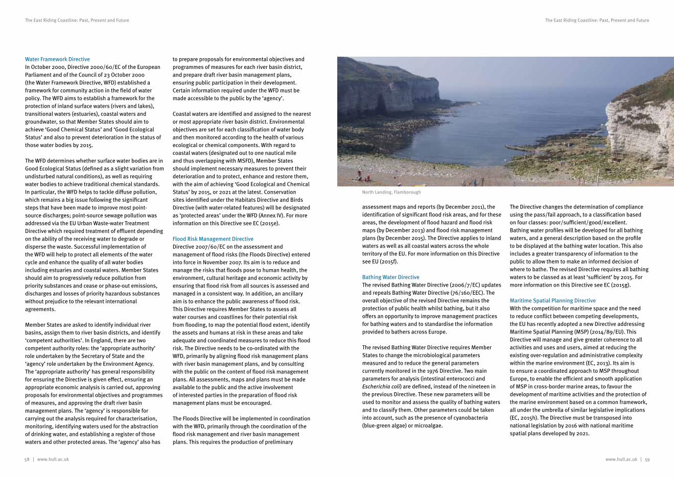
58 | www.hull.ac.uk www.hull.ac.uk | 59
The East Riding Coastline: Past, Present and Future The East Riding Coastline: Past, Present and Future
Water Framework Directive In October 2000, Directive 2000/60/EC of the European Parliament and of the Council of 23 October 2000 (the Water Framework Directive, WFD) established a framework for community action in the field of water policy. The WFD aims to establish a framework for the protection of inland surface waters (rivers and lakes), transitional waters (estuaries), coastal waters and groundwater, so that Member States should aim to achieve ‘Good Chemical Status’ and ‘Good Ecological Status’ and also to prevent deterioration in the status of those water bodies by 2015.
The WFD determines whether surface water bodies are in Good Ecological Status (defined as a slight variation from undisturbed natural conditions), as well as requiring water bodies to achieve traditional chemical standards. In particular, the WFD helps to tackle diffuse pollution, which remains a big issue following the significant steps that have been made to improve most point-source discharges; point-source sewage pollution was addressed via the EU Urban Waste-water Treatment Directive which required treatment of effluent depending on the ability of the receiving water to degrade or disperse the waste. Successful implementation of the WFD will help to protect all elements of the water cycle and enhance the quality of all water bodies including estuaries and coastal waters. Member States should aim to progressively reduce pollution from priority substances and cease or phase-out emissions, discharges and losses of priority hazardous substances without prejudice to the relevant international agreements.
Member States are asked to identify individual river basins, assign them to river basin districts, and identify ‘competent authorities’. In England, there are two competent authority roles: the ‘appropriate authority’ role undertaken by the Secretary of State and the ‘agency’ role undertaken by the Environment Agency. The ‘appropriate authority’ has general responsibility for ensuring the Directive is given effect, ensuring an appropriate economic analysis is carried out, approving proposals for environmental objectives and programmes of measures, and approving the draft river basin management plans. The ‘agency’ is responsible for carrying out the analysis required for characterisation, monitoring, identifying waters used for the abstraction of drinking water, and establishing a register of those waters and other protected areas. The ‘agency’ also has
to prepare proposals for environmental objectives and programmes of measures for each river basin district, and prepare draft river basin management plans, ensuring public participation in their development. Certain information required under the WFD must be made accessible to the public by the ‘agency’.
Coastal waters are identified and assigned to the nearest or most appropriate river basin district. Environmental objectives are set for each classification of water body and then monitored according to the health of various ecological or chemical components. With regard to coastal waters (designated out to one nautical mile and thus overlapping with MSFD), Member States should implement necessary measures to prevent their deterioration and to protect, enhance and restore them, with the aim of achieving ‘Good Ecological and Chemical Status’ by 2015, or 2021 at the latest. Conservation sites identified under the Habitats Directive and Birds Directive (with water-related features) will be designated as ‘protected areas’ under the WFD (Annex IV). For more information on this Directive see EC (2015e).
Flood Risk Management DirectiveDirective 2007/60/EC on the assessment and management of flood risks (the Floods Directive) entered into force in November 2007. Its aim is to reduce and manage the risks that floods pose to human health, the environment, cultural heritage and economic activity by ensuring that flood risk from all sources is assessed and managed in a consistent way. In addition, an ancillary aim is to enhance the public awareness of flood risk. This Directive requires Member States to assess all water courses and coastlines for their potential risk from flooding, to map the potential flood extent, identify the assets and humans at risk in these areas and take adequate and coordinated measures to reduce this flood risk. The Directive needs to be co-ordinated with the WFD, primarily by aligning flood risk management plans with river basin management plans, and by consulting with the public on the content of flood risk management plans. All assessments, maps and plans must be made available to the public and the active involvement of interested parties in the preparation of flood risk management plans must be encouraged.
The Floods Directive will be implemented in coordination with the WFD, primarily through the coordination of the flood risk management and river basin management plans. This requires the production of preliminary
assessment maps and reports (by December 2011), the identification of significant flood risk areas, and for these areas, the development of flood hazard and flood risk maps (by December 2013) and flood risk management plans (by December 2015). The Directive applies to inland waters as well as all coastal waters across the whole territory of the EU. For more information on this Directive see EU (2015f).
Bathing Water DirectiveThe revised Bathing Water Directive (2006/7/EC) updates and repeals Bathing Water Directive (76/160/EEC). The overall objective of the revised Directive remains the protection of public health whilst bathing, but it also offers an opportunity to improve management practices for bathing waters and to standardise the information provided to bathers across Europe.
The revised Bathing Water Directive requires Member States to change the microbiological parameters measured and to reduce the general parameters currently monitored in the 1976 Directive. Two main parameters for analysis (intestinal enterococci and Escherichia coli) are defined, instead of the nineteen in the previous Directive. These new parameters will be used to monitor and assess the quality of bathing waters and to classify them. Other parameters could be taken into account, such as the presence of cyanobacteria (blue-green algae) or microalgae.
The Directive changes the determination of compliance using the pass/fail approach, to a classification based on four classes: poor/sufficient/good/excellent. Bathing water profiles will be developed for all bathing waters, and a general description based on the profile to be displayed at the bathing water location. This also includes a greater transparency of information to the public to allow them to make an informed decision of where to bathe. The revised Directive requires all bathing waters to be classed as at least ‘sufficient’ by 2015. For more information on this Directive see EC (2015g).
Maritime Spatial Planning DirectiveWith the competition for maritime space and the need to reduce conflict between competing developments, the EU has recently adopted a new Directive addressing Maritime Spatial Planning (MSP) (2014/89/EU). This Directive will manage and give greater coherence to all activities and uses and users, aimed at reducing the existing over-regulation and administrative complexity within the marine environment (EC, 2013). Its aim is to ensure a coordinated approach to MSP throughout Europe, to enable the efficient and smooth application of MSP in cross-border marine areas, to favour the development of maritime activities and the protection of the marine environment based on a common framework, all under the umbrella of similar legislative implications (EC, 2015h). The Directive must be transposed into national legislation by 2016 with national maritime spatial plans developed by 2021.
North Landing, Flamborough
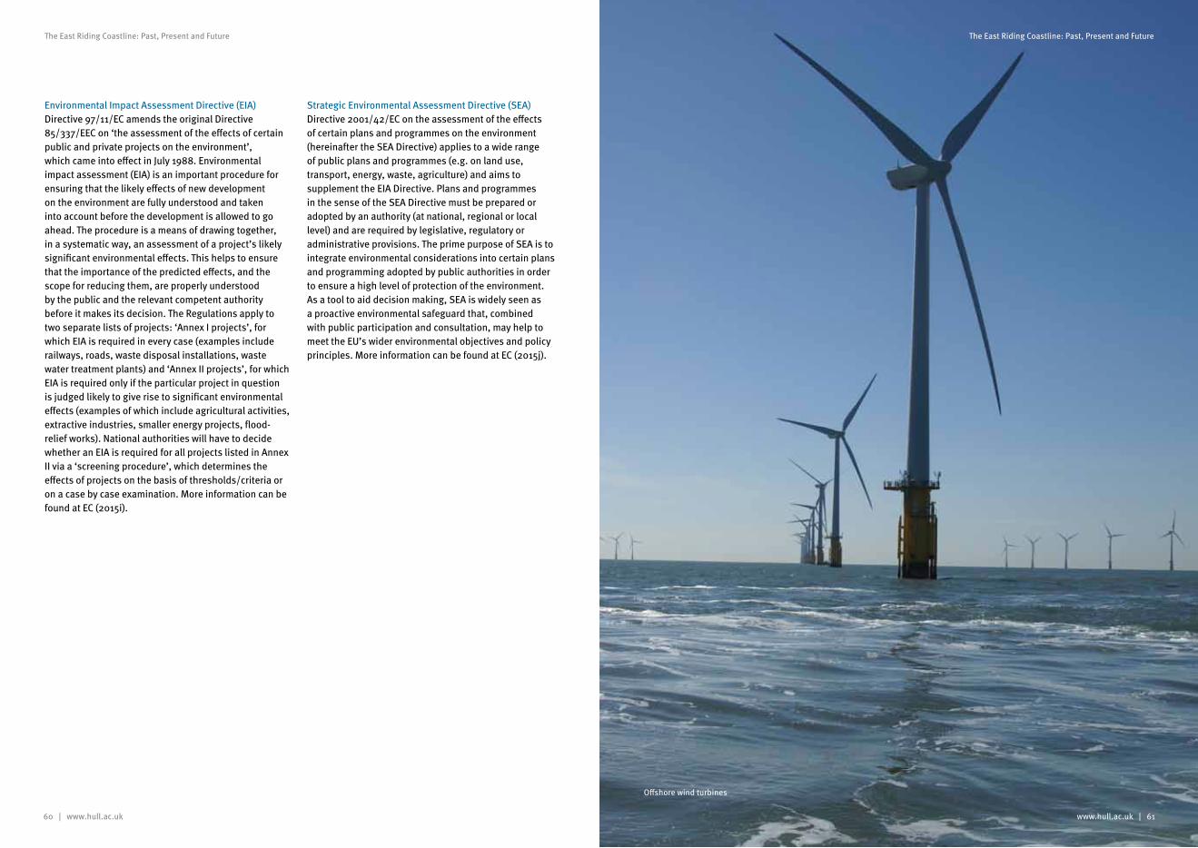
60 | www.hull.ac.uk
The East Riding Coastline: Past, Present and Future
www.hull.ac.uk | 61
The East Riding Coastline: Past, Present and Future
Environmental Impact Assessment Directive (EIA)Directive 97/11/EC amends the original Directive 85/337/EEC on ‘the assessment of the effects of certain public and private projects on the environment’, which came into effect in July 1988. Environmental impact assessment (EIA) is an important procedure for ensuring that the likely effects of new development on the environment are fully understood and taken into account before the development is allowed to go ahead. The procedure is a means of drawing together, in a systematic way, an assessment of a project’s likely significant environmental effects. This helps to ensure that the importance of the predicted effects, and the scope for reducing them, are properly understood by the public and the relevant competent authority before it makes its decision. The Regulations apply to two separate lists of projects: ‘Annex I projects’, for which EIA is required in every case (examples include railways, roads, waste disposal installations, waste water treatment plants) and ‘Annex II projects’, for which EIA is required only if the particular project in question is judged likely to give rise to significant environmental effects (examples of which include agricultural activities, extractive industries, smaller energy projects, flood-relief works). National authorities will have to decide whether an EIA is required for all projects listed in Annex II via a ‘screening procedure’, which determines the effects of projects on the basis of thresholds/criteria or on a case by case examination. More information can be found at EC (2015i).
Strategic Environmental Assessment Directive (SEA)Directive 2001/42/EC on the assessment of the effects of certain plans and programmes on the environment (hereinafter the SEA Directive) applies to a wide range of public plans and programmes (e.g. on land use, transport, energy, waste, agriculture) and aims to supplement the EIA Directive. Plans and programmes in the sense of the SEA Directive must be prepared or adopted by an authority (at national, regional or local level) and are required by legislative, regulatory or administrative provisions. The prime purpose of SEA is to integrate environmental considerations into certain plans and programming adopted by public authorities in order to ensure a high level of protection of the environment. As a tool to aid decision making, SEA is widely seen as a proactive environmental safeguard that, combined with public participation and consultation, may help to meet the EU’s wider environmental objectives and policy principles. More information can be found at EC (2015j).
Offshore wind turbines
62 | www.hull.ac.uk www.hull.ac.uk | 63
The East Riding Coastline: Past, Present and Future The East Riding Coastline: Past, Present and Future
UK Legislation
Primary legislation in England is made by the UK Parliament. Laws may be amended through successive legislation or specific Amendment Acts. As a result, laws relating to specific subjects (e.g. protected sites) often occur in more than one piece of legislation. Statutory instruments are the most important form of delegated legislation in allowing the provisions of an Act of Parliament to be subsequently brought into force or altered without Parliament having to pass a new Act. They generally deal with matters which are too detailed to be included in an Act of Parliament and can easily be amended or repealed, thus enabling governments to respond quickly to changing circumstances. Statutory instruments can be used to amend, update or enforce existing primary legislation.
Today, approximately 80% of all UK environmental legislation is derived from EU law, with more than 200 legal acts currently in force. Acts relate to a wide range of issues, including biodiversity, farming and forestry, fisheries, air pollution, waste and climate change. As a Member State, the UK Government provides evidence and expertise to develop policies and is responsible (together with the other Member States’ Governments) for agreeing and implementing EU legislation (JNCC, 2015a).
There are many pieces of UK legislation managing activities on land, along the coast and at sea. Legislation in the past has been enacted piecemeal to deal with sectoral issues e.g. fishing, coastal defence, energy, recreation, planning and development (both terrestrial and at sea), conservation, flooding, harbours, environmental impact assessments, pollution and navigation. However, in recent years, new legislation has been more holistic in nature (e.g. the Marine and Coastal Access Act 2009), dealing with multi-sectoral issues aiming to manage the coast as a whole. There are many pieces of legislation relating to the management of our coasts and seas. For simplicity, key pieces of legislation relating to coastal protection and conservation along the East Yorkshire coast have been identified, and their scope described, below.
Coast Protection Act 1949The Coast Protection Act 1949 aims ‘to amend the law relating to the protection of the coastline of Great Britain against erosion and encroachment by the sea’. The Act gives Local Authorities permissive powers to
undertake coast protection works on their frontage to combat erosion. It is the key piece of legislation for matters relating to coastal erosion risk on the open coast (Environment Agency, 2010a).
Part I of the Act gives a coast protection authority the power to undertake the necessary protection of any land in its area from erosion or encroachment by the sea. The authority may enter into an agreement with any other person to carry out the work and may also buy any land required to carry out coast protection work, or land which is to be protected by new coast protection work. They also have powers to compulsorily acquire land in accordance with the Acquisition of Land Act 1961. The powers also enable work to be undertaken on land or property, including construction, alteration, improvement, repair, maintenance, demolition or removal, but such work must be for the purpose of protecting land from erosion and encroachment and not for any other purpose.
The Flood and Water Management Act 2010 has made some changes to the Coast Protection Act (see below for more information) and the Marine and Coastal Access Act 2009 has also taken over the controls and licenses under Part II of the Coast Protection Act which relate to provisions for safety of navigation between the shoreline and the limits of territorial waters. For the text of the Act see HM Government (2013a).
Flood and Water Management Act 2010The Flood and Water Management Act 2010 aims to provide better, more sustainable management of flood and coastal risks for people, homes and businesses, and the environment. The Act creates a more comprehensive and risk-based regime for managing the threat of flood and coastal erosion, which, for the first time, embraces all sources of flooding. The Environment Agency will have powers for all sea flooding and coastal erosion works, with Local Authorities having powers, with Environment Agency consent – to carry out coastal erosion works and sea flooding works. The Act also replaces Regional Flood Defence Committees (RFDCs) with Regional Flood and Coastal Committees (RFCCs), reflecting the extension of the committees’ role to cover coastal erosion.
The Flood and Water Management Act makes the Environment Agency a relevant authority under the Coast Protection Act, a duty that it shares with other coastal protection authorities. This means the Environment
Agency has discretionary powers when exercising its coastal functions such as:• carrying out emergency coast protection works in any
area it thinks necessary;• administering the Flood Defence Grant in Aid (FDGiA)
partnership funding on behalf of Defra;• directing an owner or occupier of land to undertake
coast protection works where they have a historical obligation to maintain defences, and
• compulsory purchasing land if ordered by the Minister for England or Wales.
For the text of the Act see HM Government (2013b).
Marine and Coastal Access Act 2009The Marine and Coastal Access Act 2009 provides a framework to regulate marine activities to ensure the sustainable use and protection of marine resources and to safeguard clean, healthy, safe, productive and biologically diverse oceans and seas. The 2009 Act sets out in legislation the proposals which were widely supported in A Sea Change, the UK Government’s White Paper published in March 2007 (Defra, 2007). One of the central aims of the 2009 Act is to provide a more coherent and simpler legal regime, through which a better balance can be established between, on the one hand, economic and social marine activities and, on the other, the protection of the marine environment and marine biodiversity. As a result of the devolution process in the UK, the 2009 Act is specific to England and Wales.
Amongst other outcomes, the Act:• establishes the Marine Management Organisation
(MMO) for English waters;• introduces a flexible new mechanism for the
designation of Marine Conservation Zones (MCZs) which, together with European Marine Sites (EMSs), will form a representative network of Marine Protected Areas (MPAs), to help fulfil the UK’s European and International commitments for the establishment of coherent and representative network of MPAs;
• encourages the development and implementation of an integrated marine planning system in England and Wales, through Marine Plans;
• improves and streamlines the system for licensing marine activities;
• reforms inshore fisheries management, and• introduces new powers to extend recreational access
to the English coast and enables the creation of a continuous access route around the English coast (National Trails).
As stated above, the 2009 Act introduces a streamlined, transparent and consistent system for licensing marine developments providing, as far as possible, a ‘one-stop shop’ for each project. The system replaces existing controls and licenses under Part II of the Coast Protection Act 1949 and Part II of the Food and Environment Protection Act 1985. For the text of the Act see HM Government (2013c).
Conservation LegislationThe main piece of legislation relating to nature conservation in Great Britain is the Wildlife and Countryside Act 1981 (as amended). This Act is supplemented, inter alia, by provisions in the Countryside and Rights of Way (CRoW) Act 2000 and the Natural Environment and Rural Communities Act 2006 (in England and Wales). The Wildlife and Countryside Act places parts of the Birds Directive 2009 and the Bern Convention into national legislation. It includes a number of Schedules containing details of the protected species, their level of protection and which are subject to periodic review (usually every five years). The Act provides for the notification and confirmation of SSSIs (sites identified for their flora, fauna, geological or physiographical features) and contains measures for their protection and management. The 1981 Act also allowed for the designation of Marine Nature Reserves (MNR), designed to conserve marine life and geological or physiographical features of special interest out to 12nm. In the UK, only three statutory MNRs were designated - at Lundy Island, Skomer and Strangford Lough. As a direct result of the 2009 Marine and Coastal Access Act, the waters around Lundy Island off the North Devon coast became England’s first Marine Conservation Zone (MCZ) in January 2010.
Both the Habitats and Birds Directives have been transposed into UK national legislation by the Conservation of Habitats and Species (Amendment) Regulations 2012 and Offshore Marine Conservation (Natural Habitats, & c.) (Amendment) Regulations 2012, both of which came into force on 16 August 2012. The former applies to the terrestrial and inshore (up to 12 nautical miles) environments, while the latter applies to offshore waters. Under the provisions of the Directives, the UK Government has an obligation to recommend selected areas as SACs for the protection of habitats and species, and SPAs for the protection of birds.
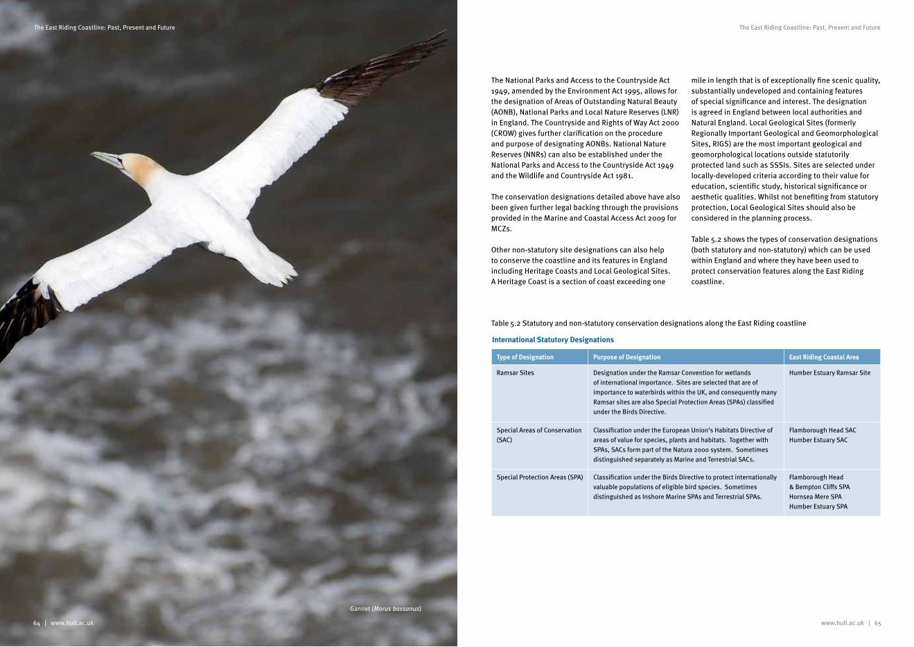
64 | www.hull.ac.uk www.hull.ac.uk | 65
The East Riding Coastline: Past, Present and Future The East Riding Coastline: Past, Present and Future
The National Parks and Access to the Countryside Act 1949, amended by the Environment Act 1995, allows for the designation of Areas of Outstanding Natural Beauty (AONB), National Parks and Local Nature Reserves (LNR) in England. The Countryside and Rights of Way Act 2000 (CROW) gives further clarification on the procedure and purpose of designating AONBs. National Nature Reserves (NNRs) can also be established under the National Parks and Access to the Countryside Act 1949 and the Wildlife and Countryside Act 1981.
The conservation designations detailed above have also been given further legal backing through the provisions provided in the Marine and Coastal Access Act 2009 for MCZs.
Other non-statutory site designations can also help to conserve the coastline and its features in England including Heritage Coasts and Local Geological Sites. A Heritage Coast is a section of coast exceeding one
mile in length that is of exceptionally fine scenic quality, substantially undeveloped and containing features of special significance and interest. The designation is agreed in England between local authorities and Natural England. Local Geological Sites (formerly Regionally Important Geological and Geomorphological Sites, RIGS) are the most important geological and geomorphological locations outside statutorily protected land such as SSSIs. Sites are selected under locally-developed criteria according to their value for education, scientific study, historical significance or aesthetic qualities. Whilst not benefiting from statutory protection, Local Geological Sites should also be considered in the planning process.
Table 5.2 shows the types of conservation designations (both statutory and non-statutory) which can be used within England and where they have been used to protect conservation features along the East Riding coastline.
Type of Designation Purpose of Designation East Riding Coastal Area
Ramsar Sites Designation under the Ramsar Convention for wetlands of international importance. Sites are selected that are of importance to waterbirds within the UK, and consequently many Ramsar sites are also Special Protection Areas (SPAs) classified under the Birds Directive.
Humber Estuary Ramsar Site
Special Areas of Conservation (SAC)
Classification under the European Union’s Habitats Directive of areas of value for species, plants and habitats. Together with SPAs, SACs form part of the Natura 2000 system. Sometimes distinguished separately as Marine and Terrestrial SACs.
Flamborough Head SACHumber Estuary SAC
Special Protection Areas (SPA) Classification under the Birds Directive to protect internationally valuable populations of eligible bird species. Sometimes distinguished as Inshore Marine SPAs and Terrestrial SPAs.
Flamborough Head & Bempton Cliffs SPAHornsea Mere SPAHumber Estuary SPA
Table 5.2 Statutory and non-statutory conservation designations along the East Riding coastline
International Statutory Designations
Gannet (Morus bassanus)
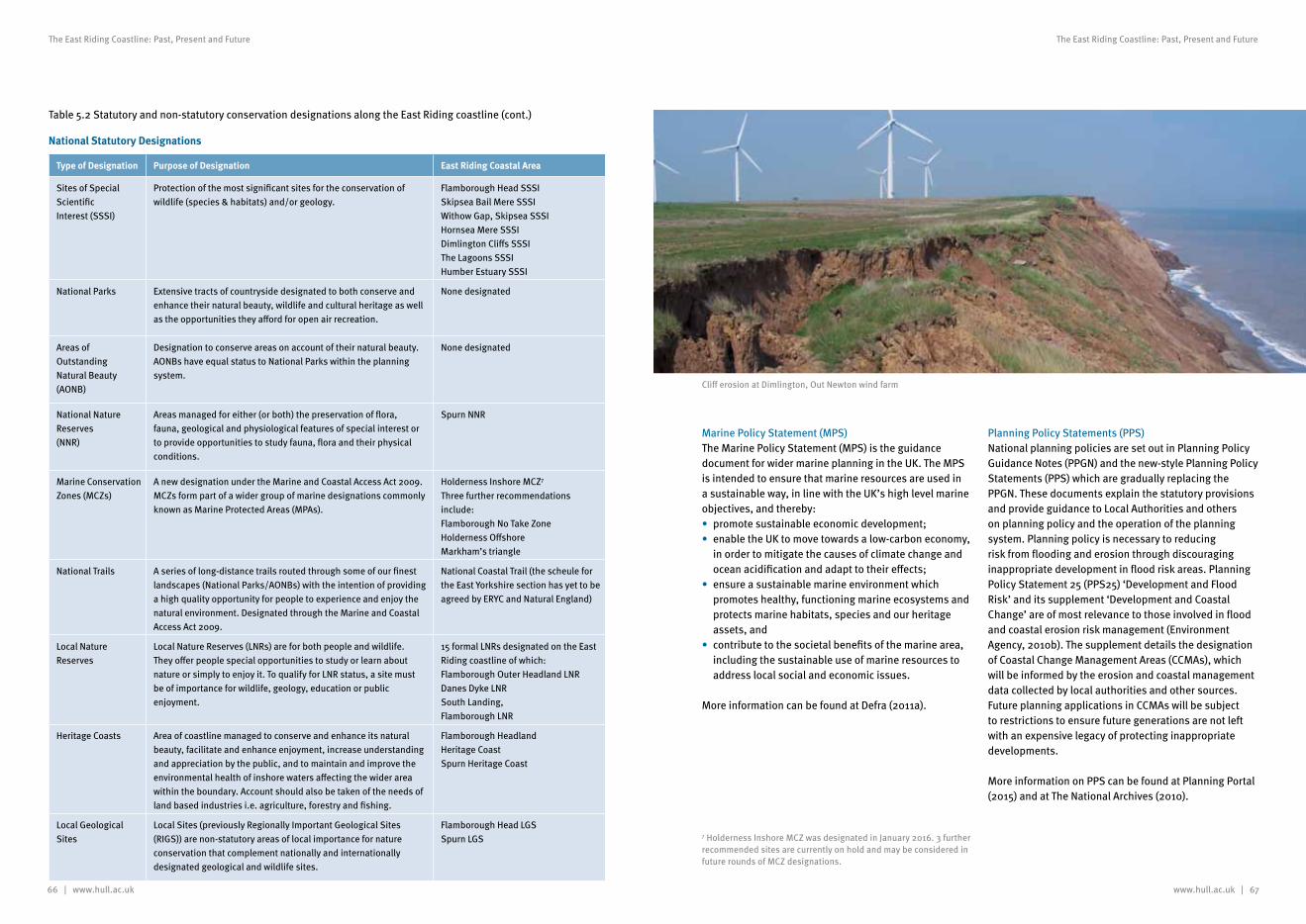
66 | www.hull.ac.uk www.hull.ac.uk | 67
The East Riding Coastline: Past, Present and Future The East Riding Coastline: Past, Present and Future
Type of Designation Purpose of Designation East Riding Coastal Area
Sites of Special ScientificInterest (SSSI)
Protection of the most significant sites for the conservation ofwildlife (species & habitats) and/or geology.
Flamborough Head SSSISkipsea Bail Mere SSSIWithow Gap, Skipsea SSSIHornsea Mere SSSIDimlington Cliffs SSSIThe Lagoons SSSIHumber Estuary SSSI
National Parks Extensive tracts of countryside designated to both conserve andenhance their natural beauty, wildlife and cultural heritage as well as the opportunities they afford for open air recreation.
None designated
Areas of OutstandingNatural Beauty (AONB)
Designation to conserve areas on account of their natural beauty.AONBs have equal status to National Parks within the planningsystem.
None designated
National Nature Reserves(NNR)
Areas managed for either (or both) the preservation of flora,fauna, geological and physiological features of special interest orto provide opportunities to study fauna, flora and their physicalconditions.
Spurn NNR
Marine Conservation Zones (MCZs)
A new designation under the Marine and Coastal Access Act 2009. MCZs form part of a wider group of marine designations commonly known as Marine Protected Areas (MPAs).
Holderness Inshore MCZ7
Three further recommendations include:Flamborough No Take ZoneHolderness OffshoreMarkham’s triangle
National Trails A series of long-distance trails routed through some of our finestlandscapes (National Parks/AONBs) with the intention of providing a high quality opportunity for people to experience and enjoy the natural environment. Designated through the Marine and Coastal Access Act 2009.
National Coastal Trail (the scheule for the East Yorkshire section has yet to be agreed by ERYC and Natural England)
Local Nature Reserves
Local Nature Reserves (LNRs) are for both people and wildlife.They offer people special opportunities to study or learn aboutnature or simply to enjoy it. To qualify for LNR status, a site mustbe of importance for wildlife, geology, education or publicenjoyment.
15 formal LNRs designated on the East Riding coastline of which:Flamborough Outer Headland LNRDanes Dyke LNRSouth Landing, Flamborough LNR
Heritage Coasts Area of coastline managed to conserve and enhance its naturalbeauty, facilitate and enhance enjoyment, increase understanding and appreciation by the public, and to maintain and improve the environmental health of inshore waters affecting the wider area within the boundary. Account should also be taken of the needs of land based industries i.e. agriculture, forestry and fishing.
Flamborough HeadlandHeritage CoastSpurn Heritage Coast
Local Geological Sites
Local Sites (previously Regionally Important Geological Sites (RIGS)) are non-statutory areas of local importance for natureconservation that complement nationally and internationallydesignated geological and wildlife sites.
Flamborough Head LGSSpurn LGS
Table 5.2 Statutory and non-statutory conservation designations along the East Riding coastline (cont.)
National Statutory Designations
Marine Policy Statement (MPS)The Marine Policy Statement (MPS) is the guidance document for wider marine planning in the UK. The MPS is intended to ensure that marine resources are used in a sustainable way, in line with the UK’s high level marine objectives, and thereby:• promote sustainable economic development;• enable the UK to move towards a low-carbon economy,
in order to mitigate the causes of climate change and ocean acidification and adapt to their effects;
• ensure a sustainable marine environment which promotes healthy, functioning marine ecosystems and protects marine habitats, species and our heritage assets, and
• contribute to the societal benefits of the marine area, including the sustainable use of marine resources to address local social and economic issues.
More information can be found at Defra (2011a).
Planning Policy Statements (PPS)National planning policies are set out in Planning Policy Guidance Notes (PPGN) and the new-style Planning Policy Statements (PPS) which are gradually replacing the PPGN. These documents explain the statutory provisions and provide guidance to Local Authorities and others on planning policy and the operation of the planning system. Planning policy is necessary to reducing risk from flooding and erosion through discouraging inappropriate development in flood risk areas. Planning Policy Statement 25 (PPS25) ‘Development and Flood Risk’ and its supplement ‘Development and Coastal Change’ are of most relevance to those involved in flood and coastal erosion risk management (Environment Agency, 2010b). The supplement details the designation of Coastal Change Management Areas (CCMAs), which will be informed by the erosion and coastal management data collected by local authorities and other sources. Future planning applications in CCMAs will be subject to restrictions to ensure future generations are not left with an expensive legacy of protecting inappropriate developments.
More information on PPS can be found at Planning Portal (2015) and at The National Archives (2010).
7 Holderness Inshore MCZ was designated in January 2016. 3 further recommended sites are currently on hold and may be considered in future rounds of MCZ designations.
Cliff erosion at Dimlington, Out Newton wind farm
68 | www.hull.ac.uk www.hull.ac.uk | 69
The East Riding Coastline: Past, Present and Future The East Riding Coastline: Past, Present and Future
Non-Statutory Policies & Plans
Shoreline Management Plans (SMPs)At a local and regional level, strategic guidance for managing coastal flooding and erosion risks is provided through Shoreline Management Plans (SMPs). These are non-statutory, high-level planning documents that provide a large-scale assessment of the risks associated with coastal processes and present a long-term policy framework to reduce these risks to people and the developed, historic and natural environment in a sustainable manner. SMPs are developed for sections of coastline, or sediment cells, which have similar processes affecting them. An SMP will cover a length of coast which will incorporate one or more sediment cells and will typically include a number of communities and land uses, and a series of different physical features and coastal defences.
SMPs should define, in general terms, the risks to people and the developed, historic and natural environment within the SMP area, and set out the intended management policy for the coast over the next 100 years. In turn this will achieve the best balance of all the features and interests that occur along the shoreline. Policy options are separated into the short-term (present - 2025), the medium-term (2025 - 2055), and the long-term (2055 - 2105) in order to identify the most sustainable approaches to managing coastal erosion and flooding risks for each epoch (time period). The preferred policy options should comply with international and national conservation legislation and biodiversity obligations.
All SMPs consider four standard policy options. The four policy options, as presented in the Humber Estuary Coastal Authorities Group (HECAG) Flamborough Head to Gibraltar Point SMP, are shown in Table 5.3.
In general, the SMP is separated into policy units, and the most appropriate management approach is identified for each policy unit. These four policies may be applied to any of the three timescales: short-term (up to the year 2025); medium term (between 2025 and 2055); and long-term (between 2055 and 2105). These three periods are known as ‘epochs’ within the SMP.
When holding the existing defence line, many factors need to be considered, e.g. whether or not to take sea level rise into account, and for how long defences will be sustainable or affordable. In some cases, defences may not be intended to be permanent; for example in some locations, investment in defences may cease in the future to allow for managed realignment of the shoreline. Cases are assessed on an individual basis and, in each case,
the options are considered carefully by stakeholders and coastal groups and discussed widely before any decision is reached (Environment Agency, 2015).
It is important to note that the SMP does not guarantee funding and approval of flood or coast protection schemes or other management activities, and that land ownership, technical ability to deliver, climate change implications and local acceptability may all affect the deliverability of proposals (Environment Agency, 2010b). The affordability of SMP policy options and the availability of funding via flood and coastal erosion risk management grant in aid (FCRM GiA8) will always present a significant issue especially during times of economic difficulties.
Government guidance for developing SMPs has been produced, based on reviews of first generation plans (developed in the early 2000s) and the improvements which needed to be made (Defra, 2011b). The latest guidance from the UK Department for Environment, Food and Rural Affairs (Defra) emphasises the need to connect SMPs (that remain non-statutory plans) and the elements of the statutory planning system. SMPs should also be considered during any local planning applications. The guidance also emphasises the importance of preparing a Strategic Environmental Assessment (SEA) and an Appropriate Assessment (AA). These assessments should, inter alia, consider the prevailing environmental opportunities and constraints, the affordability of any preferred policy option(s), and the need to address the three pillars of sustainability (economy, society and environment). The ‘Making Space for Water’ initiative provides important strategic guidance for incorporating sustainable development into all flood risk management and coastal erosion decisions and operations (Defra, 2005), including the second generation of SMPs.
The HECAG SMP is one of 22 second-generation SMPs to be developed. It addresses the coast from Flamborough Head in the East Riding to Gibraltar Point in Lincolnshire (Cell 2a9) (Scott Wilson, 2010b). East Riding of Yorkshire Council (ERYC) was the lead authority during the development of the HECAG SMP, working with North East Lincolnshire Council, East Lindsey District Council, Lincolnshire County Council, the Environment Agency, Natural England, the National Farmers’ Union and Historic England (formally English Heritage). The HECAG SMP was adopted by all partners in 2011 before being ratified by Defra on 22nd June 2011.
Integrated Coastal Zone Management (ICZM) PlansICZM is an approach to coastal management, promoted as a means of involving all those with an interest in the coast in its long-term management. The approach aims to address environmental, social and economic challenges that arise in coastal areas and resolve any emerging conflicts. ICZM is based on eight key principles described in the EU ICZM Recommendation (described above), which have been recognised by the UK Government as playing a key part in the development of a strategic approach to the management of coastal areas in England.
In 2000, ERYC and other interested parties agreed to develop an ICZM Plan for the East Riding coastal zone. After 18 months’ development involving over 80 organisations, the plan ‘Towards a sustainable coast’ was launched on 10 July 2002, making it one of the first ICZM plans to be produced in England. ERYC’s ICZM Plan was a non-statutory document that recognised the links in coastal management both between different geographical areas and sectors. It also recognised that many different organisations and agencies can make a difference to the long-term management of the zone and aims to gain commitment from these to a common vision. The ICZM Plan laid out policies for managing all aspects of the coastal zone and also informed the review of the SMP, which started back in 2002. This initiative was accompanied by the formation of a Coastal Forum to encourage engagement with coastal communities and allowing the sharing of information. Whilst the ICZM approach is still valid, many of the fundamental aims and objectives of the ICZM Plan for the East Riding coastal zone have since been picked up within the HECAG SMP, which has now effectively superseded ICZM Plan.
Shoreline Management Policy Description of Policy
Hold the line (HTL) Hold the existing defence line. This policy will cover those situations where work or operations are carried out on the existing defences (such as beach recharge, rebuilding the toe of a structure, building offshore breakwaters and so on). Included in this policy are other policies that involve operations to the back of existing defences (such as building secondary floodwalls) where they form an essential part of maintaining the current coastal defence system.
Advance the line (ATL) Advance the existing defence line by building new defences on the seaward side of the original defences. Using this policy should be limited to those policy units where significant land reclamation is considered.
Managed realignment (MR) Managed realignment by allowing the shoreline to move landwards, with management to control or limit movement (such as building new defences on the landward side of the original defences).
No active intervention (NAI) A decision not to invest in providing or maintaining defences.
Table 5.3 Shoreline Management Policy Options8 FRCM GiA is funding provided by central government for the management of flood and coastal erosion risk in England. It is allocated by the Environment Agency and is used by the Environment Agency, local authorities and internal drainage boards (IDBs) to pay for a range of activities including schemes that help reduce the risk of flooding and coastal erosion.
9 The UK shoreline has been divided into a series of major sediment cells and the identification of the boundaries of which has been based on natural coastal process behaviour. There are 11 major sediment cells around the coast of Wales and England and these have been sub-divided for the purpose of coastal defence management into Sediment Sub-Cells. Sediment sub-cells are discrete lengths of shoreline bounded by either headlands or estuaries and define the limits of each Shoreline Management Plan.
Undefended coastline north of Hornsea, covering Bay View Avenue and Belvedere Park.
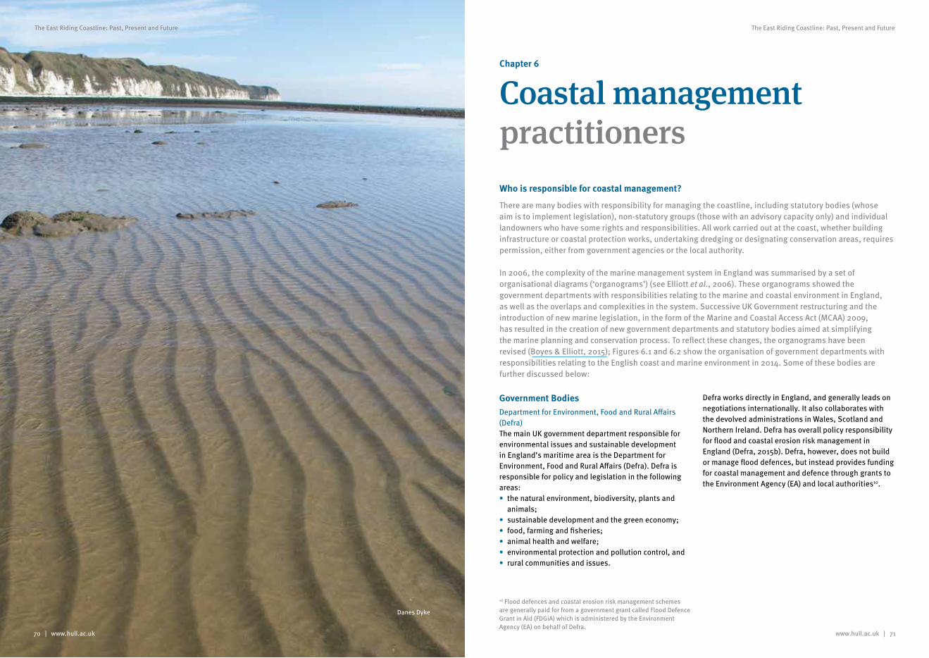
www.hull.ac.uk | 71
The East Riding Coastline: Past, Present and Future
70 | www.hull.ac.uk
The East Riding Coastline: Past, Present and Future
Chapter 6
Coastal management practitionersWho is responsible for coastal management?
There are many bodies with responsibility for managing the coastline, including statutory bodies (whose aim is to implement legislation), non-statutory groups (those with an advisory capacity only) and individual landowners who have some rights and responsibilities. All work carried out at the coast, whether building infrastructure or coastal protection works, undertaking dredging or designating conservation areas, requires permission, either from government agencies or the local authority.
In 2006, the complexity of the marine management system in England was summarised by a set of organisational diagrams (‘organograms’) (see Elliott et al., 2006). These organograms showed the government departments with responsibilities relating to the marine and coastal environment in England, as well as the overlaps and complexities in the system. Successive UK Government restructuring and the introduction of new marine legislation, in the form of the Marine and Coastal Access Act (MCAA) 2009, has resulted in the creation of new government departments and statutory bodies aimed at simplifying the marine planning and conservation process. To reflect these changes, the organograms have been revised (Boyes & Elliott, 2015); Figures 6.1 and 6.2 show the organisation of government departments with responsibilities relating to the English coast and marine environment in 2014. Some of these bodies are further discussed below:
Government BodiesDepartment for Environment, Food and Rural Affairs (Defra)The main UK government department responsible for environmental issues and sustainable development in England’s maritime area is the Department for Environment, Food and Rural Affairs (Defra). Defra is responsible for policy and legislation in the following areas:• the natural environment, biodiversity, plants and
animals;• sustainable development and the green economy;• food, farming and fisheries;• animal health and welfare;• environmental protection and pollution control, and• rural communities and issues.
Defra works directly in England, and generally leads on negotiations internationally. It also collaborates with the devolved administrations in Wales, Scotland and Northern Ireland. Defra has overall policy responsibility for flood and coastal erosion risk management in England (Defra, 2015b). Defra, however, does not build or manage flood defences, but instead provides funding for coastal management and defence through grants to the Environment Agency (EA) and local authorities10.
10 Flood defences and coastal erosion risk management schemes are generally paid for from a government grant called Flood Defence Grant in Aid (FDGiA) which is administered by the Environment Agency (EA) on behalf of Defra.
Danes Dyke
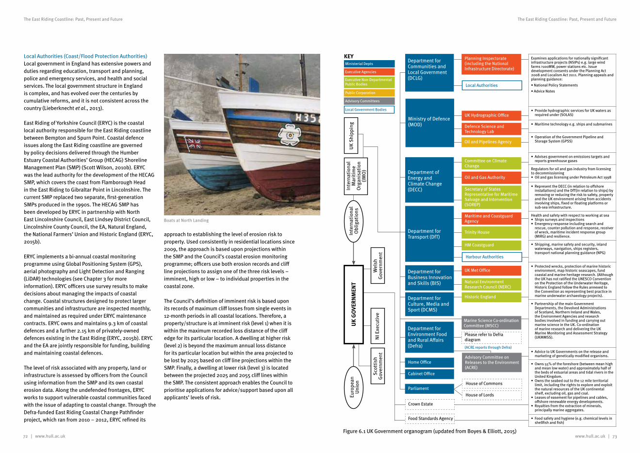
72 | www.hull.ac.uk
The East Riding Coastline: Past, Present and Future
www.hull.ac.uk | 73
The East Riding Coastline: Past, Present and Future
Local Authorities (Coast/Flood Protection Authorities)Local government in England has extensive powers and duties regarding education, transport and planning, police and emergency services, and health and social services. The local government structure in England is complex, and has evolved over the centuries by cumulative reforms, and it is not consistent across the country (Lieberknecht et al., 2013).
East Riding of Yorkshire Council (ERYC) is the coastal local authority responsible for the East Riding coastline between Bempton and Spurn Point. Coastal defence issues along the East Riding coastline are governed by policy decisions delivered through the Humber Estuary Coastal Authorities’ Group (HECAG) Shoreline Management Plan (SMP) (Scott Wilson, 2010b). ERYC was the lead authority for the development of the HECAG SMP, which covers the coast from Flamborough Head in the East Riding to Gibraltar Point in Lincolnshire. The current SMP replaced two separate, first-generation SMPs produced in the 1990s. The HECAG SMP has been developed by ERYC in partnership with North East Lincolnshire Council, East Lindsey District Council, Lincolnshire County Council, the EA, Natural England, the National Farmers’ Union and Historic England (ERYC, 2015b).
ERYC implements a bi-annual coastal monitoring programme using Global Positioning System (GPS), aerial photography and Light Detection and Ranging (LiDAR) technologies (see Chapter 3 for more information). ERYC officers use survey results to make decisions about managing the impacts of coastal change. Coastal structures designed to protect larger communities and infrastructure are inspected monthly, and maintained as required under ERYC maintenance contracts. ERYC owns and maintains 9.3 km of coastal defences and a further 2.15 km of privately-owned defences existing in the East Riding (ERYC, 2015b). ERYC and the EA are jointly responsible for funding, building and maintaining coastal defences.
The level of risk associated with any property, land or infrastructure is assessed by officers from the Council using information from the SMP and its own coastal erosion data. Along the undefended frontages, ERYC works to support vulnerable coastal communities faced with the issue of adapting to coastal change. Through the Defra-funded East Riding Coastal Change Pathfinder project, which ran from 2010 – 2012, ERYC refined its
approach to establishing the level of erosion risk to property. Used consistently in residential locations since 2009, the approach is based upon projections within the SMP and the Council’s coastal erosion monitoring programme; officers use both erosion records and cliff line projections to assign one of the three risk levels – imminent, high or low – to individual properties in the coastal zone.
The Council’s definition of imminent risk is based upon its records of maximum cliff losses from single events in 12-month periods in all coastal locations. Therefore, a property/structure is at imminent risk (level 1) when it is within the maximum recorded loss distance of the cliff edge for its particular location. A dwelling at higher risk (level 2) is beyond the maximum annual loss distance for its particular location but within the area projected to be lost by 2025 based on cliff line projections within the SMP. Finally, a dwelling at lower risk (level 3) is located between the projected 2025 and 2055 cliff lines within the SMP. The consistent approach enables the Council to prioritise applications for advice/support based upon all applicants’ levels of risk.
Boats at North Landing
Department for Transport (DfT)
Ministry of Defence (MOD)
UK Hydrographic Office
Defence Science and Technology Lab
Oil and Pipelines Agency
Department of Energy and Climate Change (DECC)
Committee on Climate Change
Oil and Gas Authority
Secretary of States Representative for Maritime Salvage and Intervention (SOREP)
Maritime and Coastguard Agency
Trinity House
HM Coastguard
Harbour Authorities
Department for Business Innovation and Skills (BIS)
UK Met Office
Natural Environment Research Council (NERC)
Department for Culture, Media and Sport (DCMS)
Historic England
Marine Science Co-ordination Committee (MSCC)
Please refer to Defra diagram
Home Office
Cabinet Office
Parliament
Crown Estate
Department for Environment Food and Rural Affairs (Defra) (ACRE reports through Defra)
Advisory Committee on Releases to the Environment (ACRE)
House of Commons
House of Lords
Food Standards Agency
Examines applications for nationally significant infrastructure projects (NSIPs) e.g. large wind farms >100MW, power stations etc. Issue development consents under the Planning Act 2008 and Localism Act 2011. Planning appeals and planning guidance:•NationalPolicyStatements•AdviceNotes
•ProvidehydrographicservicesforUKwatersasrequired under (SOLAS)
•Maritimetechnologye.g.shipsandsubmarines
•OperationoftheGovernmentPipelineandStorage System (GPSS)
•Advisesgovernmentonemissionstargetsandreports greenhouse gases
Regulators for oil and gas industry from licensing to decommissioning • OilandgaslicensingunderPetroleumAct1998
•RepresenttheDECC(inrelationtooffshoreinstallations) and the DfT(in relation to ships) by removing or reducing the risk to safety, property and the UK environment arising from accidents involving ships, fixed or floating platforms or sub-sea infrastructure.
Health and safety with respect to working at sea•Shipssurveysandinspections•Emergencyresponseincludingsearchand
rescue, counter pollution and response, receiver of wreck, maritime incident response group (MIRG) and resilience.
•Shipping,marinesafetyandsecurity,inlandwaterways, navigation, ships registers, transport national planning guidance (NPG)
•Protectedwrecks,protectionofmarinehistoricenvironment, map historic seascapes, fund coastal and marine heritage research. (Although the UK has not ratified the UNESCO Convention on the Protection of the Underwater Heritage, Historic England follow the Rules annexed to the Convention as representing best practice in marine underwater archaeology projects).
•PartnershipofthemainGovernmentDepartments, the Devolved Administrations of Scotland, Northern Ireland and Wales, the Environment Agencies and research bodies involved in funding and carrying out marine science in the UK. Co-ordination of marine research and delivering the UK Marine Monitoring and Assessment Strategy (UKMMSS).
•AdvicetoUKGovernmentsonthereleaseandmarketing of genetically modified organisms.
•Owns55%oftheforeshore(betweenmeanhighand mean low water) and approximately half of the beds of estuarial areas and tidal rivers in the United Kingdom.
•Ownstheseabedouttothe12mileterritoriallimit, including the rights to explore and exploit the natural resources of the UK continental shelf, excluding oil, gas and coal.
•Leasesofeasementforpipelinesandcables,offshore renewable energy developments.
•Royaltiesfromtheextractionofminerals,principally marine aggregates.
•Foodsafetyandhygiene(e.g.chemicallevelsinshellfish and fish)
Department for Communities and Local Government (DCLG)
Planning Inspectorate (including the National Infrastructure Directorate)
Local Authorities
NI E
xecu
tive
Euro
pean
U
nion
Scot
tish
Gov
ernm
ent
Wel
sh
Gov
ernm
ent
UK
GO
VERN
MEN
TU
K Sh
ippi
ngIn
tern
atio
nal
Obl
igat
ions
Inte
rnat
iona
l M
ariti
me
Org
anis
atio
n (IM
O)
KEYMinisterial Depts
Executive Agencies
Executive Non-Departmental Public Bodies
Public Corporation
Advisory Committees
Local Government Bodies
Figure 6.1 UK Government organogram (updated from Boyes & Elliott, 2015)
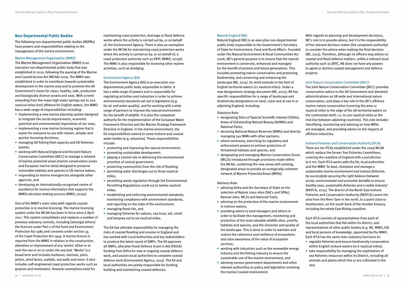
74 | www.hull.ac.uk www.hull.ac.uk | 75
The East Riding Coastline: Past, Present and Future The East Riding Coastline: Past, Present and Future
Natural England (NE)Natural England (NE) is an executive non-departmental public body responsible to the Government’s Secretary of State for Environment, Food and Rural Affairs. Founded under the Natural Environment & Rural Communities Act 2006, NE’s general purpose is to ensure that the natural environment is conserved, enhanced and managed for the benefit of present and future generations. This includes promoting nature conservation and protecting biodiversity, and conserving and enhancing the landscape (NE, 2015). Its remit extends to the limit of English territorial waters (12 nautical miles). Under a new designations strategy document (NE, 2012), NE has specific responsibilities for a range of landscape and biodiversity designations on land, coast and at sea in or adjoining England, including:
Statutory Role:• designating Sites of Special Scientific Interest (SSSIs),
Areas of Outstanding Natural Beauty (AONBs) and National Parks;
• declaring National Nature Reserves (NNRs) and directly managing 140 NNRs with other partners;
• where necessary, exercising its regulatory and enforcement powers to achieve protection of threatened habitats and species, and
• designating and managing Marine Conservation Zones (MCZs) introduced through provisions made within the MCAA, combining the new zones with existing, designated areas to provide an ecologically-coherent network of Marine Protected Areas (MPAs).
Advisory Role:• advising Defra and the Secretary of State on the
selection of Natura 2000 sites (SACs and SPAs), Ramsar sites, MCZs and National Trails;
• advising on the protection of the marine environment in inshore waters;
• providing advice to land managers and others in order to facilitate the management, monitoring and protection of the most valuable wildlife sites, priority habitats and species, and the character and quality of the landscape. This is done in order to maintain and restore the coherence and resilience of ecosystems and raise awareness of the value of ecosystem services;
• working with industries such as the renewable energy industry and the fishing industry to ensure the sustainable use of the marine environment, and
• advising various government departments and other relevant authorities on policy and legislation involving the marine/coastal environment.
With regards to planning and development decisions, NE’s role is to provide advice, but it is the responsibility of the relevant decision-maker (the competent authority) to consider the advice when making the final decision (NE, 2015). Therefore, although its officers may advise on coastal and flood defence matters, unlike a relevant local authority such as ERYC, NE does not have any powers to agree or decline coastal management and defence projects.
Joint Nature Conservation Committee (JNCC)The Joint Nature Conservation Committee (JNCC) provides conservation advice to the UK Government and devolved administrations on UK-wide and international nature conservation, and plays a key role in the UK’s offshore marine nature conservation (covering the area 12 nautical miles to the edge of the UK territorial waters on the continental shelf, i.e. to 200 nautical miles or the mid-line between adjoining countries). This role includes identifying, monitoring and advising on how MPAs are managed, and providing advice on the impacts of offshore industries.
Inshore Fisheries and Conservation Authority (IFCA)There are ten IFCAs established under the 2009 MCAA which replace the former Sea Fisheries Committees, covering the coastline of England with a jurisdiction to 6 nm. Each IFCA works with the EA, local authorities and the MMO ‘to lead, champion and manage a sustainable marine environment and inshore fisheries, by successfully securing the right balance between social, environmental and economic benefits to ensure healthy seas, sustainable fisheries and a viable industry’ (NEIFCA, 2015). The district of the North East Inshore Fisheries and Conservation Authority (NEIFCA) covers the area from the River Tyne in the north, to a point close to Humberston, on the south bank of the Humber Estuary, including the whole East Riding coastline.
Each IFCA consists of representatives from each of the local authorities that fall within its district, and representatives of other public bodies (e.g. NE, MMO, EA) and local persons of knowledge, appointed by the MMO. Each IFCA has the same main statutory functions to:• regulate fisheries and ensure biodiversity conservation
within English inshore waters (to 6 nautical miles);• take responsibility for managing the exploitation of
sea fisheries resources within its District, including all animals and plants which live or are cultivated in the sea;
Non-Departmental Public BodiesThe following non-departmental public bodies (NDPBs) have powers and responsibilities relating to the management of the marine environment:
Marine Management Organisation (MMO)The Marine Management Organisation (MMO) is an executive non-departmental public body that was established in 2010, following the passing of the Marine and Coastal Access Act (MCAA) 2009. The MMO was established in order to contribute towards sustainable development in the marine area and to promote the UK Government’s vision for clean, healthy, safe, productive and biologically diverse oceans and seas. With a remit extending from the mean high water springs out to 200 nautical miles (nm) offshore for English waters, the MMO has a wide range of responsibilities including:• implementing a new marine planning system designed
to integrate the social requirements, economic potential and environmental imperatives of our seas;
• implementing a new marine licensing regime that is easier for everyone to use with clearer, simpler and quicker licensing decisions;
• managing UK fishing fleet capacity and UK fisheries quotas;
• working with Natural England and the Joint Nature Conservation Committee (JNCC) to manage a network of marine protected areas (marine conservation zones and European marine sites) designed to preserve vulnerable habitats and species in UK marine waters,
• responding to marine emergencies alongside other agencies, and
• developing an internationally-recognised centre of excellence for marine information that supports the MMOs decision-making process (MMO, 2015a).
One of the MMO’s main roles with regards coastal protection is in marine licensing. The marine licensing system under the MCAA has been in force since 6 April 2011. This system consolidates and replaces a number of previous statutory controls, including (amongst others) the licences under Part 2 of the Food and Environment Protection Act 1985 and consents under section 34 of the Coast Protection Act 1949. A marine licence is required from the MMO in relation to the construction, alteration or improvement of any ‘works’ either in or over the sea or on or under the sea bed. ‘Works’ is a broad term and includes harbours, marinas, piers, jetties, wind farms, outfalls, sea walls and more. It also includes soft-engineered coast protection works such as groynes and revetments. However exemptions exist for
maintaining coast protection, drainage or flood defence works where the activity is carried out by, or on behalf of, the Environment Agency. There is also an exemption under the MCAA for maintaining coast protection works where the activity is carried on by, or on behalf of, a coast protection authority such as ERYC (MMO, 2015b). The MMO is also responsible for licensing other marine activities, such as dredging.
Environment Agency (EA)The Environment Agency (EA) is an executive non-departmental public body responsible to Defra. It has a wide range of powers and is responsible for regulating activities and industries in order to achieve environmental standards set out in legislation (e.g. for air and water quality), and for working with a wide range of partners to improve the natural environment for the benefit of wildlife. It is also the competent authority for the implementation of the European Water Framework Directive and the Marine Strategy Framework Directive in England. In the marine environment, the EA responsibilities extend to some inshore and coastal water bodies (e.g. estuaries). These responsibilities include:• protecting and improving the natural environment;• promoting sustainable development;• playing a central role in delivering the environmental
priorities of central government;• protecting communities from the risk of flooding;• permitting water discharges out to three nautical
miles;• permitting waste regulation through the Environmental
Permitting Regulations 2008 out to twelve nautical miles;
• establishing and enforcing environmental standards, monitoring compliance with environment standards, and reporting on the state of the environment;
• managing flood risk, and• managing fisheries for salmon, sea trout, eel, smelt
and lamprey out to six nautical miles.
The EA has ultimate responsibility for managing the risks of coastal flooding and erosion in England and has worked with Local Authorities and key stakeholders to produce the latest round of SMPs. The EA approves all SMPs, allocates Flood Defence Grant in Aid (FDGiA) funding from Defra for new or ongoing coastal defence work, and assists local authorities to complete coastal defence work (Environment Agency, 2015). The EA and local authorities are jointly responsible for funding, building and maintaining coastal defences.
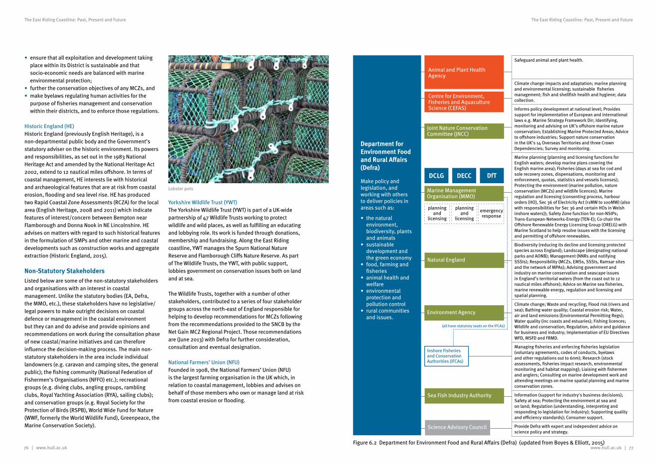
76 | www.hull.ac.uk www.hull.ac.uk | 77
The East Riding Coastline: Past, Present and Future The East Riding Coastline: Past, Present and Future
• ensure that all exploitation and development taking place within its District is sustainable and that socio-economic needs are balanced with marine environmental protection;
• further the conservation objectives of any MCZs, and• make byelaws regulating human activities for the
purpose of fisheries management and conservation within their districts, and to enforce those regulations.
Historic England (HE)Historic England (previously English Heritage), is a non-departmental public body and the Government’s statutory adviser on the historic environment. Its powers and responsibilities, as set out in the 1983 National Heritage Act and amended by the National Heritage Act 2002, extend to 12 nautical miles offshore. In terms of coastal management, HE interests lie with historical and archaeological features that are at risk from coastal erosion, flooding and sea level rise. HE has produced two Rapid Coastal Zone Assessments (RCZA) for the local area (English Heritage, 2008 and 2011) which indicate features of interest/concern between Bempton near Flamborough and Donna Nook in NE Lincolnshire. HE advises on matters with regard to such historical features in the formulation of SMPs and other marine and coastal developments such as construction works and aggregate extraction (Historic England, 2015).
Non-Statutory StakeholdersListed below are some of the non-statutory stakeholders and organisations with an interest in coastal management. Unlike the statutory bodies (EA, Defra, the MMO, etc.), these stakeholders have no legislative/legal powers to make outright decisions on coastal defence or management in the coastal environment but they can and do advise and provide opinions and recommendations on work during the consultation phase of new coastal/marine initiatives and can therefore influence the decision-making process. The main non-statutory stakeholders in the area include individual landowners (e.g. caravan and camping sites, the general public); the fishing community (National Federation of Fishermen’s Organisations (NFFO) etc.); recreational groups (e.g. diving clubs, angling groups, rambling clubs, Royal Yachting Association (RYA), sailing clubs); and conservation groups (e.g. Royal Society for the Protection of Birds (RSPB), World Wide Fund for Nature (WWF, formerly the World Wildlife Fund), Greenpeace, the Marine Conservation Society).
Yorkshire Wildlife Trust (YWT)The Yorkshire Wildlife Trust (YWT) is part of a UK-wide partnership of 47 Wildlife Trusts working to protect wildlife and wild places, as well as fulfilling an educating and lobbying role. Its work is funded through donations, membership and fundraising. Along the East Riding coastline, YWT manages the Spurn National Nature Reserve and Flamborough Cliffs Nature Reserve. As part of The Wildlife Trusts, the YWT, with public support, lobbies government on conservation issues both on land and at sea.
The Wildlife Trusts, together with a number of other stakeholders, contributed to a series of four stakeholder groups across the north-east of England responsible for helping to develop recommendations for MCZs following from the recommendations provided to the SNCB by the Net Gain MCZ Regional Project. Those recommendations are (June 2013) with Defra for further consideration, consultation and eventual designation.
National Farmers’ Union (NFU)Founded in 1908, the National Farmers’ Union (NFU) is the largest farming organisation in the UK which, in relation to coastal management, lobbies and advises on behalf of those members who own or manage land at risk from coastal erosion or flooding.
Figure 6.2 Department for Environment Food and Rural Affairs (Defra) (updated from Boyes & Elliott, 2015)
Lobster pots
Department for Environment Food and Rural Affairs (Defra)
Make policy and legislation, and working with others to deliver policies in areas such as:
• thenaturalenvironment, biodiversity, plants and animals
• sustainabledevelopment and the green economy
• food, farmingandfisheries
• animalhealthandwelfare
• environmentalprotection and pollution control
• ruralcommunitiesand issues.
Safeguard animal and plant health.
Climate change impacts and adaptation; marine planning and environmental licensing; sustainable fisheries management; fish and shellfish health and hygiene; data collection.
Informs policy development at national level; Provides support for implementation of European and international laws e.g. Marine Strategy Framework Dir; Identifying, monitoring and advising on UK’s offshore marine nature conservation; Establishing Marine Protected Areas; Advice to offshore industries; Support nature conservation in the UK’s 14 Overseas Territories and three Crown Dependencies; Survey and monitoring.
Marine planning (planning and licensing functions for English waters; develop marine plans covering the English marine area); Fisheries (days at sea for cod and sole recovery zones, dispensations, monitoring and enforcement, quotas, statistics and vessels licenses); Protecting the environment (marine pollution, nature conservation (MCZs) and wildlife licences); Marine regulation and licensing (consenting process, harbour orders (HO), Sec 36 of Electricity Act (>1MW to 100MW) (also with responsibilities for Sec 36 and certain HOs in Welsh inshore waters)); Safety Zone function for non-NSIPs; Trans-European-Networks-Energy (TEN-E); Co-chair the Offshore Renewable Energy Licensing Group (ORELG) with Marine Scotland to help resolve issues with the licensing and permitting of offshore renewables.
Biodiversity (reducing its decline and licensing protected species across England); Landscape (designating national parks and AONB); Management (NNRs and notifying SSSIs); Responsibility (MCZs, EMSs, SSSIs, Ramsar sites and the network of MPAs); Advising government and industry on marine conservation and seascape issues in England’s territorial waters (from the coast out to 12 nautical miles offshore); Advice on Marine sea fisheries, marine renewable energy, regulation and licensing and spatial planning.
Climate change; Waste and recycling; Flood risk (rivers and sea); Bathing water quality; Coastal erosion risk; Water, air and land emissions (Environmental Permitting Regs); Water quality (inc coasts and estuaries); Fishing licences; Wildlife and conservation; Regulation, advice and guidance for business and industry; Implementation of EU Directives WFD, MSFD and FRMD.
Managing fisheries and enforcing fisheries legislation (voluntary agreements, codes of conducts, byelaws and other regulations out to 6nm); Research (stock assessments, fisheries impact research, environmental monitoring and habitat mapping); Liaising with fishermen and anglers; Consulting on marine development work and attending meetings on marine spatial planning and marine conservation zones.
Information (support for industry's business decisions); Safety at sea; Protecting the environment at sea and on land; Regulation (understanding, interpreting and responding to legislation for industry); Supporting quality and efficiency standards); Consumer support.
Provide Defra with expert and independent advice on science policy and strategy.
(all have statutory seats on the IFCAs)
Animal and Plant Health Agency
Centre for Environment, Fisheries and Aquaculture Science (CEFAS)
Joint Nature Conservation Committee (JNCC)
Marine Management Organisation (MMO)
DCLG DECC DfT
planning and
licensing
planning and
licensing
emergency response
Natural England
Environment Agency
Inshore Fisheries and Conservation Authorities (IFCAs)
Sea Fish Industry Authority
Science Advisory Council
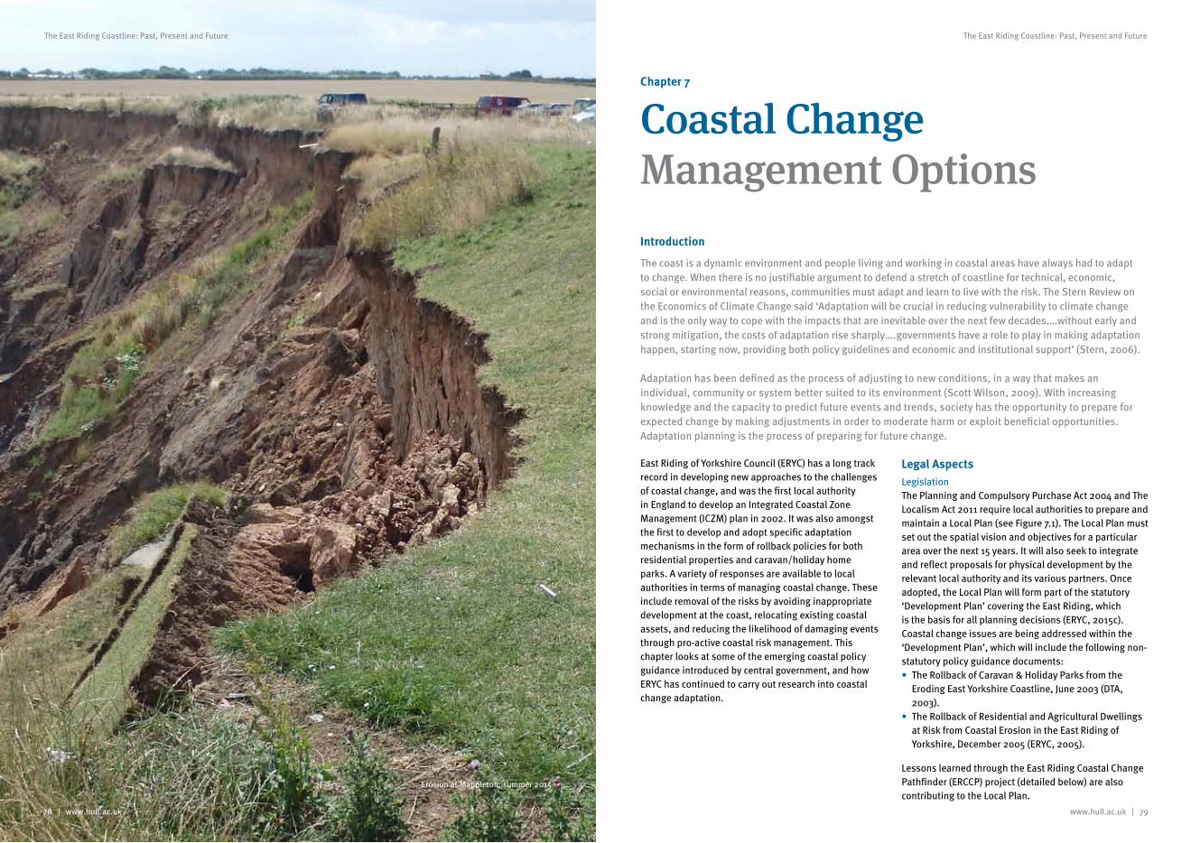
www.hull.ac.uk | 79
The East Riding Coastline: Past, Present and Future
78 | www.hull.ac.uk
The East Riding Coastline: Past, Present and Future
Chapter 7
Coastal Change Management OptionsIntroduction
The coast is a dynamic environment and people living and working in coastal areas have always had to adapt to change. When there is no justifiable argument to defend a stretch of coastline for technical, economic, social or environmental reasons, communities must adapt and learn to live with the risk. The Stern Review on the Economics of Climate Change said ‘Adaptation will be crucial in reducing vulnerability to climate change and is the only way to cope with the impacts that are inevitable over the next few decades.…without early and strong mitigation, the costs of adaptation rise sharply….governments have a role to play in making adaptation happen, starting now, providing both policy guidelines and economic and institutional support’ (Stern, 2006).
Adaptation has been defined as the process of adjusting to new conditions, in a way that makes an individual, community or system better suited to its environment (Scott Wilson, 2009). With increasing knowledge and the capacity to predict future events and trends, society has the opportunity to prepare for expected change by making adjustments in order to moderate harm or exploit beneficial opportunities. Adaptation planning is the process of preparing for future change.
East Riding of Yorkshire Council (ERYC) has a long track record in developing new approaches to the challenges of coastal change, and was the first local authority in England to develop an Integrated Coastal Zone Management (ICZM) plan in 2002. It was also amongst the first to develop and adopt specific adaptation mechanisms in the form of rollback policies for both residential properties and caravan/holiday home parks. A variety of responses are available to local authorities in terms of managing coastal change. These include removal of the risks by avoiding inappropriate development at the coast, relocating existing coastal assets, and reducing the likelihood of damaging events through pro-active coastal risk management. This chapter looks at some of the emerging coastal policy guidance introduced by central government, and how ERYC has continued to carry out research into coastal change adaptation.
Legal AspectsLegislationThe Planning and Compulsory Purchase Act 2004 and The Localism Act 2011 require local authorities to prepare and maintain a Local Plan (see Figure 7.1). The Local Plan must set out the spatial vision and objectives for a particular area over the next 15 years. It will also seek to integrate and reflect proposals for physical development by the relevant local authority and its various partners. Once adopted, the Local Plan will form part of the statutory ‘Development Plan’ covering the East Riding, which is the basis for all planning decisions (ERYC, 2015c). Coastal change issues are being addressed within the ‘Development Plan’, which will include the following non-statutory policy guidance documents:• The Rollback of Caravan & Holiday Parks from the
Eroding East Yorkshire Coastline, June 2003 (DTA, 2003).
• The Rollback of Residential and Agricultural Dwellings at Risk from Coastal Erosion in the East Riding of Yorkshire, December 2005 (ERYC, 2005).
Lessons learned through the East Riding Coastal Change Pathfinder (ERCCP) project (detailed below) are also contributing to the Local Plan.
Erosion at Mappleton, summer 2015
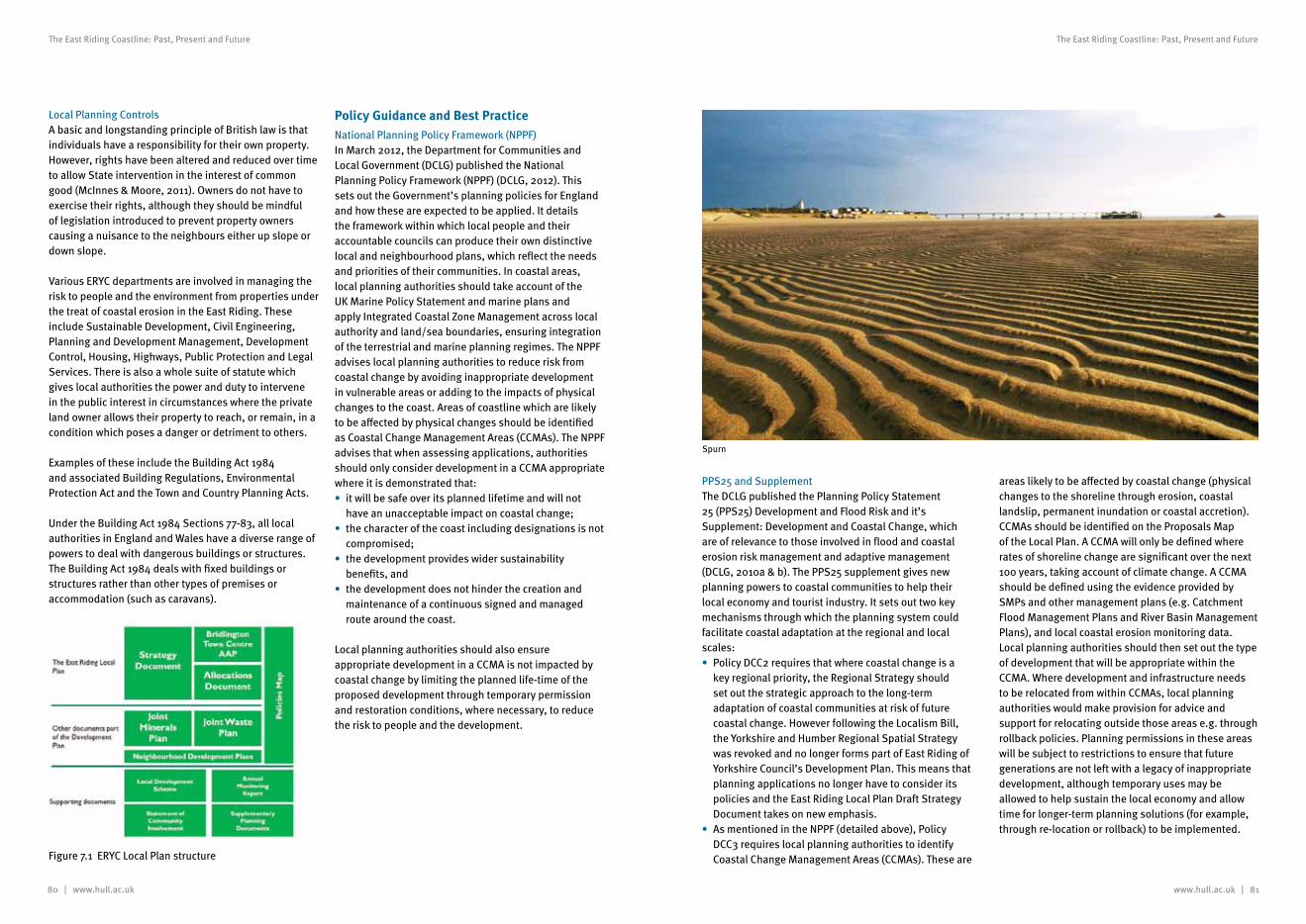
80 | www.hull.ac.uk www.hull.ac.uk | 81
The East Riding Coastline: Past, Present and Future The East Riding Coastline: Past, Present and Future
Local Planning ControlsA basic and longstanding principle of British law is that individuals have a responsibility for their own property. However, rights have been altered and reduced over time to allow State intervention in the interest of common good (McInnes & Moore, 2011). Owners do not have to exercise their rights, although they should be mindful of legislation introduced to prevent property owners causing a nuisance to the neighbours either up slope or down slope.
Various ERYC departments are involved in managing the risk to people and the environment from properties under the treat of coastal erosion in the East Riding. These include Sustainable Development, Civil Engineering, Planning and Development Management, Development Control, Housing, Highways, Public Protection and Legal Services. There is also a whole suite of statute which gives local authorities the power and duty to intervene in the public interest in circumstances where the private land owner allows their property to reach, or remain, in a condition which poses a danger or detriment to others.
Examples of these include the Building Act 1984 and associated Building Regulations, Environmental Protection Act and the Town and Country Planning Acts.
Under the Building Act 1984 Sections 77-83, all local authorities in England and Wales have a diverse range of powers to deal with dangerous buildings or structures. The Building Act 1984 deals with fixed buildings or structures rather than other types of premises or accommodation (such as caravans).
Policy Guidance and Best Practice National Planning Policy Framework (NPPF)In March 2012, the Department for Communities and Local Government (DCLG) published the National Planning Policy Framework (NPPF) (DCLG, 2012). This sets out the Government’s planning policies for England and how these are expected to be applied. It details the framework within which local people and their accountable councils can produce their own distinctive local and neighbourhood plans, which reflect the needs and priorities of their communities. In coastal areas, local planning authorities should take account of the UK Marine Policy Statement and marine plans and apply Integrated Coastal Zone Management across local authority and land/sea boundaries, ensuring integration of the terrestrial and marine planning regimes. The NPPF advises local planning authorities to reduce risk from coastal change by avoiding inappropriate development in vulnerable areas or adding to the impacts of physical changes to the coast. Areas of coastline which are likely to be affected by physical changes should be identified as Coastal Change Management Areas (CCMAs). The NPPF advises that when assessing applications, authorities should only consider development in a CCMA appropriate where it is demonstrated that:• it will be safe over its planned lifetime and will not
have an unacceptable impact on coastal change;• the character of the coast including designations is not
compromised;• the development provides wider sustainability
benefits, and• the development does not hinder the creation and
maintenance of a continuous signed and managed route around the coast.
Local planning authorities should also ensure appropriate development in a CCMA is not impacted by coastal change by limiting the planned life-time of the proposed development through temporary permission and restoration conditions, where necessary, to reduce the risk to people and the development.
Figure 7.1 ERYC Local Plan structure
PPS25 and SupplementThe DCLG published the Planning Policy Statement 25 (PPS25) Development and Flood Risk and it’s Supplement: Development and Coastal Change, which are of relevance to those involved in flood and coastal erosion risk management and adaptive management (DCLG, 2010a & b). The PPS25 supplement gives new planning powers to coastal communities to help their local economy and tourist industry. It sets out two key mechanisms through which the planning system could facilitate coastal adaptation at the regional and local scales:• Policy DCC2 requires that where coastal change is a
key regional priority, the Regional Strategy should set out the strategic approach to the long-term adaptation of coastal communities at risk of future coastal change. However following the Localism Bill, the Yorkshire and Humber Regional Spatial Strategy was revoked and no longer forms part of East Riding of Yorkshire Council’s Development Plan. This means that planning applications no longer have to consider its policies and the East Riding Local Plan Draft Strategy Document takes on new emphasis.
• As mentioned in the NPPF (detailed above), Policy DCC3 requires local planning authorities to identify Coastal Change Management Areas (CCMAs). These are
areas likely to be affected by coastal change (physical changes to the shoreline through erosion, coastal landslip, permanent inundation or coastal accretion). CCMAs should be identified on the Proposals Map of the Local Plan. A CCMA will only be defined where rates of shoreline change are significant over the next 100 years, taking account of climate change. A CCMA should be defined using the evidence provided by SMPs and other management plans (e.g. Catchment Flood Management Plans and River Basin Management Plans), and local coastal erosion monitoring data. Local planning authorities should then set out the type of development that will be appropriate within the CCMA. Where development and infrastructure needs to be relocated from within CCMAs, local planning authorities would make provision for advice and support for relocating outside those areas e.g. through rollback policies. Planning permissions in these areas will be subject to restrictions to ensure that future generations are not left with a legacy of inappropriate development, although temporary uses may be allowed to help sustain the local economy and allow time for longer-term planning solutions (for example, through re-location or rollback) to be implemented.
Spurn
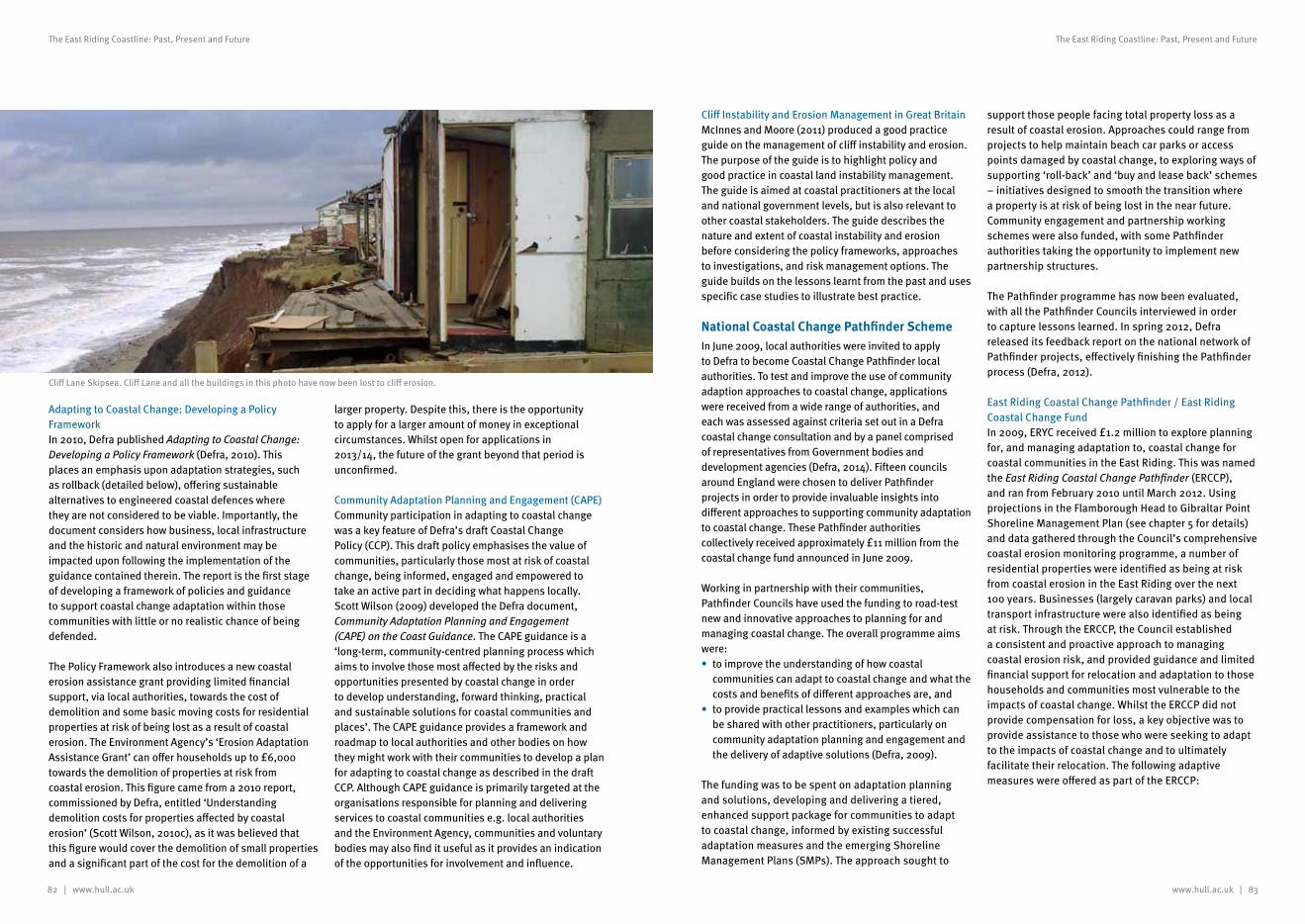
82 | www.hull.ac.uk www.hull.ac.uk | 83
The East Riding Coastline: Past, Present and Future The East Riding Coastline: Past, Present and Future
Adapting to Coastal Change: Developing a Policy FrameworkIn 2010, Defra published Adapting to Coastal Change: Developing a Policy Framework (Defra, 2010). This places an emphasis upon adaptation strategies, such as rollback (detailed below), offering sustainable alternatives to engineered coastal defences where they are not considered to be viable. Importantly, the document considers how business, local infrastructure and the historic and natural environment may be impacted upon following the implementation of the guidance contained therein. The report is the first stage of developing a framework of policies and guidance to support coastal change adaptation within those communities with little or no realistic chance of being defended.
The Policy Framework also introduces a new coastal erosion assistance grant providing limited financial support, via local authorities, towards the cost of demolition and some basic moving costs for residential properties at risk of being lost as a result of coastal erosion. The Environment Agency’s ‘Erosion Adaptation Assistance Grant’ can offer households up to £6,000 towards the demolition of properties at risk from coastal erosion. This figure came from a 2010 report, commissioned by Defra, entitled ‘Understanding demolition costs for properties affected by coastal erosion’ (Scott Wilson, 2010c), as it was believed that this figure would cover the demolition of small properties and a significant part of the cost for the demolition of a
larger property. Despite this, there is the opportunity to apply for a larger amount of money in exceptional circumstances. Whilst open for applications in 2013/14, the future of the grant beyond that period is unconfirmed.
Community Adaptation Planning and Engagement (CAPE)Community participation in adapting to coastal change was a key feature of Defra’s draft Coastal Change Policy (CCP). This draft policy emphasises the value of communities, particularly those most at risk of coastal change, being informed, engaged and empowered to take an active part in deciding what happens locally. Scott Wilson (2009) developed the Defra document, Community Adaptation Planning and Engagement (CAPE) on the Coast Guidance. The CAPE guidance is a ‘long-term, community-centred planning process which aims to involve those most affected by the risks and opportunities presented by coastal change in order to develop understanding, forward thinking, practical and sustainable solutions for coastal communities and places’. The CAPE guidance provides a framework and roadmap to local authorities and other bodies on how they might work with their communities to develop a plan for adapting to coastal change as described in the draft CCP. Although CAPE guidance is primarily targeted at the organisations responsible for planning and delivering services to coastal communities e.g. local authorities and the Environment Agency, communities and voluntary bodies may also find it useful as it provides an indication of the opportunities for involvement and influence.
Cliff Instability and Erosion Management in Great BritainMcInnes and Moore (2011) produced a good practice guide on the management of cliff instability and erosion. The purpose of the guide is to highlight policy and good practice in coastal land instability management. The guide is aimed at coastal practitioners at the local and national government levels, but is also relevant to other coastal stakeholders. The guide describes the nature and extent of coastal instability and erosion before considering the policy frameworks, approaches to investigations, and risk management options. The guide builds on the lessons learnt from the past and uses specific case studies to illustrate best practice.
National Coastal Change Pathfinder SchemeIn June 2009, local authorities were invited to apply to Defra to become Coastal Change Pathfinder local authorities. To test and improve the use of community adaption approaches to coastal change, applications were received from a wide range of authorities, and each was assessed against criteria set out in a Defra coastal change consultation and by a panel comprised of representatives from Government bodies and development agencies (Defra, 2014). Fifteen councils around England were chosen to deliver Pathfinder projects in order to provide invaluable insights into different approaches to supporting community adaptation to coastal change. These Pathfinder authorities collectively received approximately £11 million from the coastal change fund announced in June 2009.
Working in partnership with their communities, Pathfinder Councils have used the funding to road-test new and innovative approaches to planning for and managing coastal change. The overall programme aims were:• to improve the understanding of how coastal
communities can adapt to coastal change and what the costs and benefits of different approaches are, and
• to provide practical lessons and examples which can be shared with other practitioners, particularly on community adaptation planning and engagement and the delivery of adaptive solutions (Defra, 2009).
The funding was to be spent on adaptation planning and solutions, developing and delivering a tiered, enhanced support package for communities to adapt to coastal change, informed by existing successful adaptation measures and the emerging Shoreline Management Plans (SMPs). The approach sought to
support those people facing total property loss as a result of coastal erosion. Approaches could range from projects to help maintain beach car parks or access points damaged by coastal change, to exploring ways of supporting ‘roll-back’ and ‘buy and lease back’ schemes – initiatives designed to smooth the transition where a property is at risk of being lost in the near future. Community engagement and partnership working schemes were also funded, with some Pathfinder authorities taking the opportunity to implement new partnership structures.
The Pathfinder programme has now been evaluated, with all the Pathfinder Councils interviewed in order to capture lessons learned. In spring 2012, Defra released its feedback report on the national network of Pathfinder projects, effectively finishing the Pathfinder process (Defra, 2012).
East Riding Coastal Change Pathfinder / East Riding Coastal Change FundIn 2009, ERYC received £1.2 million to explore planning for, and managing adaptation to, coastal change for coastal communities in the East Riding. This was named the East Riding Coastal Change Pathfinder (ERCCP), and ran from February 2010 until March 2012. Using projections in the Flamborough Head to Gibraltar Point Shoreline Management Plan (see chapter 5 for details) and data gathered through the Council’s comprehensive coastal erosion monitoring programme, a number of residential properties were identified as being at risk from coastal erosion in the East Riding over the next 100 years. Businesses (largely caravan parks) and local transport infrastructure were also identified as being at risk. Through the ERCCP, the Council established a consistent and proactive approach to managing coastal erosion risk, and provided guidance and limited financial support for relocation and adaptation to those households and communities most vulnerable to the impacts of coastal change. Whilst the ERCCP did not provide compensation for loss, a key objective was to provide assistance to those who were seeking to adapt to the impacts of coastal change and to ultimately facilitate their relocation. The following adaptive measures were offered as part of the ERCCP:
Cliff Lane Skipsea. Cliff Lane and all the buildings in this photo have now been lost to cliff erosion.
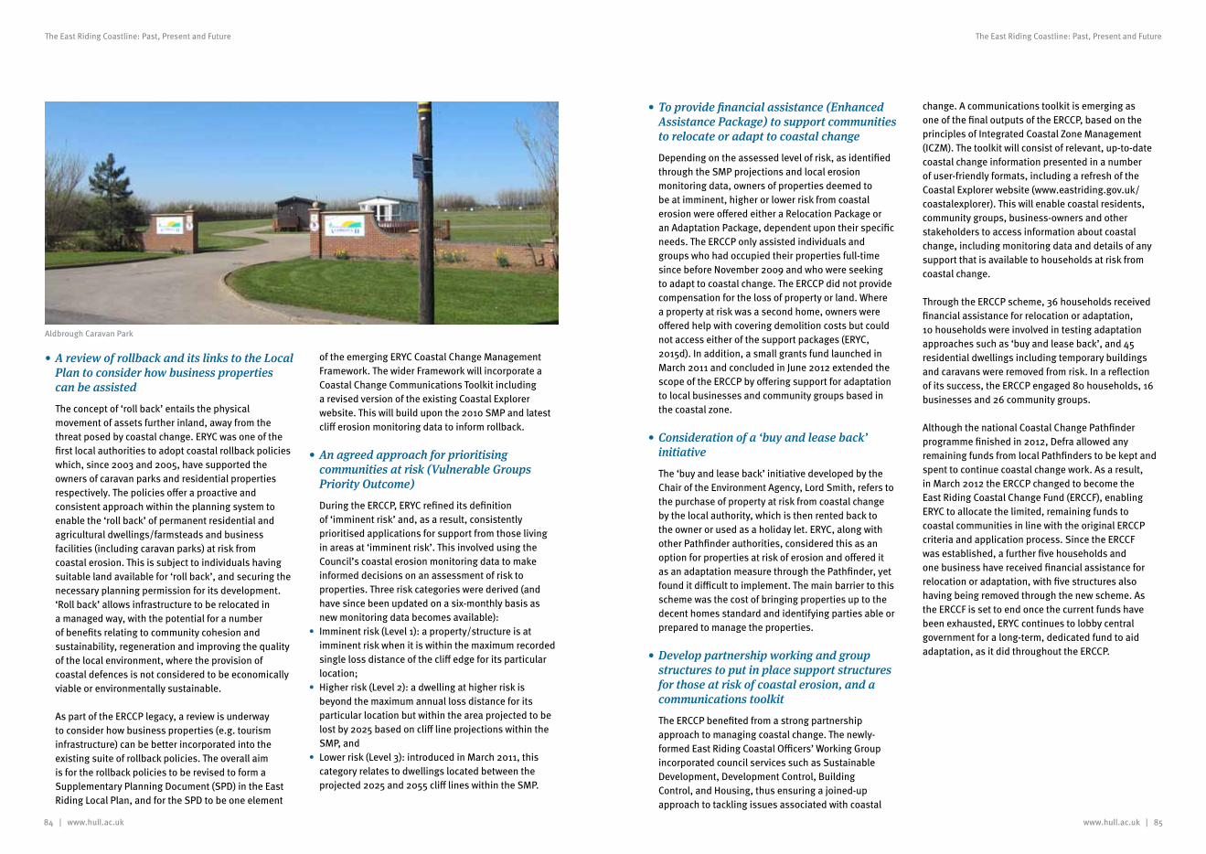
84 | www.hull.ac.uk www.hull.ac.uk | 85
The East Riding Coastline: Past, Present and Future The East Riding Coastline: Past, Present and Future
•Toprovidefinancialassistance(EnhancedAssistancePackage)tosupportcommunitiestorelocateoradapttocoastalchange
Depending on the assessed level of risk, as identified through the SMP projections and local erosion monitoring data, owners of properties deemed to be at imminent, higher or lower risk from coastal erosion were offered either a Relocation Package or an Adaptation Package, dependent upon their specific needs. The ERCCP only assisted individuals and groups who had occupied their properties full-time since before November 2009 and who were seeking to adapt to coastal change. The ERCCP did not provide compensation for the loss of property or land. Where a property at risk was a second home, owners were offered help with covering demolition costs but could not access either of the support packages (ERYC, 2015d). In addition, a small grants fund launched in March 2011 and concluded in June 2012 extended the scope of the ERCCP by offering support for adaptation to local businesses and community groups based in the coastal zone.
•Considerationofa‘buyandleaseback’initiative
The ‘buy and lease back’ initiative developed by the Chair of the Environment Agency, Lord Smith, refers to the purchase of property at risk from coastal change by the local authority, which is then rented back to the owner or used as a holiday let. ERYC, along with other Pathfinder authorities, considered this as an option for properties at risk of erosion and offered it as an adaptation measure through the Pathfinder, yet found it difficult to implement. The main barrier to this scheme was the cost of bringing properties up to the decent homes standard and identifying parties able or prepared to manage the properties.
•Developpartnershipworkingandgroupstructurestoputinplacesupportstructuresforthoseatriskofcoastalerosion,andacommunicationstoolkit
The ERCCP benefited from a strong partnership approach to managing coastal change. The newly- formed East Riding Coastal Officers’ Working Group incorporated council services such as Sustainable Development, Development Control, Building Control, and Housing, thus ensuring a joined-up approach to tackling issues associated with coastal
change. A communications toolkit is emerging as one of the final outputs of the ERCCP, based on the principles of Integrated Coastal Zone Management (ICZM). The toolkit will consist of relevant, up-to-date coastal change information presented in a number of user-friendly formats, including a refresh of the Coastal Explorer website (www.eastriding.gov.uk/coastalexplorer). This will enable coastal residents, community groups, business-owners and other stakeholders to access information about coastal change, including monitoring data and details of any support that is available to households at risk from coastal change.
Through the ERCCP scheme, 36 households received financial assistance for relocation or adaptation, 10 households were involved in testing adaptation approaches such as ‘buy and lease back’, and 45 residential dwellings including temporary buildings and caravans were removed from risk. In a reflection of its success, the ERCCP engaged 80 households, 16 businesses and 26 community groups.
Although the national Coastal Change Pathfinder programme finished in 2012, Defra allowed any remaining funds from local Pathfinders to be kept and spent to continue coastal change work. As a result, in March 2012 the ERCCP changed to become the East Riding Coastal Change Fund (ERCCF), enabling ERYC to allocate the limited, remaining funds to coastal communities in line with the original ERCCP criteria and application process. Since the ERCCF was established, a further five households and one business have received financial assistance for relocation or adaptation, with five structures also having being removed through the new scheme. As the ERCCF is set to end once the current funds have been exhausted, ERYC continues to lobby central government for a long-term, dedicated fund to aid adaptation, as it did throughout the ERCCP.
•AreviewofrollbackanditslinkstotheLocalPlantoconsiderhowbusinesspropertiescanbeassisted
The concept of ‘roll back’ entails the physical movement of assets further inland, away from the threat posed by coastal change. ERYC was one of the first local authorities to adopt coastal rollback policies which, since 2003 and 2005, have supported the owners of caravan parks and residential properties respectively. The policies offer a proactive and consistent approach within the planning system to enable the ‘roll back’ of permanent residential and agricultural dwellings/farmsteads and business facilities (including caravan parks) at risk from coastal erosion. This is subject to individuals having suitable land available for ‘roll back’, and securing the necessary planning permission for its development. ‘Roll back’ allows infrastructure to be relocated in a managed way, with the potential for a number of benefits relating to community cohesion and sustainability, regeneration and improving the quality of the local environment, where the provision of coastal defences is not considered to be economically viable or environmentally sustainable.
As part of the ERCCP legacy, a review is underway to consider how business properties (e.g. tourism infrastructure) can be better incorporated into the existing suite of rollback policies. The overall aim is for the rollback policies to be revised to form a Supplementary Planning Document (SPD) in the East Riding Local Plan, and for the SPD to be one element
of the emerging ERYC Coastal Change Management Framework. The wider Framework will incorporate a Coastal Change Communications Toolkit including a revised version of the existing Coastal Explorer website. This will build upon the 2010 SMP and latest cliff erosion monitoring data to inform rollback.
•Anagreedapproachforprioritisingcommunitiesatrisk(VulnerableGroupsPriorityOutcome)
During the ERCCP, ERYC refined its definition of ‘imminent risk’ and, as a result, consistently prioritised applications for support from those living in areas at ‘imminent risk’. This involved using the Council’s coastal erosion monitoring data to make informed decisions on an assessment of risk to properties. Three risk categories were derived (and have since been updated on a six-monthly basis as new monitoring data becomes available):
• Imminent risk (Level 1): a property/structure is at imminent risk when it is within the maximum recorded single loss distance of the cliff edge for its particular location;
• Higher risk (Level 2): a dwelling at higher risk is beyond the maximum annual loss distance for its particular location but within the area projected to be lost by 2025 based on cliff line projections within the SMP, and
• Lower risk (Level 3): introduced in March 2011, this category relates to dwellings located between the projected 2025 and 2055 cliff lines within the SMP.
Aldbrough Caravan Park
86 | www.hull.ac.uk www.hull.ac.uk | 87
The East Riding Coastline: Past, Present and Future The East Riding Coastline: Past, Present and Future
References
ABP, 1996. Southern North Sea sediment transport study, literature review and conceptual sediment transport model. Report R546. ABP Research and Consultancy Ltd, Southampton
ABP, 2000. Southern North Sea Sediment Transport Study: Phase 1. Report No. R.845
ABPmer, 2008. Conceptual Understanding of Spurn (Draft). Environment Agency. Supporting Document. R.1483 October 2008. Document. Humber ESMP
Alkyon, 1999. Environmental Assessment Process Geomorphology West Sole Stabilisations Options. Report prepared by Alkyon Hydraulic Consultancy and Research for BP
Anglian Water, 1988. Anglian Coastal Management Atlas, Anglian Water and Sir William Halcrow & Partners, Swindon. 42 figures
Anon. 1086. Domesday Book. Phillimore, London. http://www.domesdaybook.net/
Balson, P.S & Philpott, S.L. 2004. Sediment Sources, Sinks and Pathways at the Mouth of the Humber Estuary. British Geological Survey Report CR/04/159
Balson, P.S. & Harrison, D.J. 1988. Marine Aggregate Survey Phase 1: Southern North Sea, British Geological Survey, Marine Report 86/38
Balson, P.S., Tragheim, D., Newsham, R. 1996. A photographic technique to determine the potential sediment yield from recession of the Holderness coast, UK. In: Taussik, J., Mitchell, J. (Eds.), Partnership in Coastal Zone Management. Samara Publishing Ltd, Cardigan, pp. 507–514
Balson, P.S., Tragheim, D., Newsham, R. 1998. Determination and prediction of sediment yields from recession of the Holderness coast, eastern England. Proceedings of the 33rd MAFF Conference River and Coastal Engineers, London, pp. 4.5.1–4.6.2
Barnard, S., & Elliott, M. 2015. The 10-tenets of adaptive management and sustainability: A holistic framework for understanding and managing the socio-ecological system. Environmental Science & Policy, 51, 181-191
Bell, F.G. & Forster, A. 1991. The geotechnical characteristics of the till deposits of Holderness. Quaternary Engineering Geology, 7, 111-118
Bell, F.G., 2002. The geotechnical properties of some till deposits occurring along the coastal areas of eastern England. Engineering Geology, 63, 49-68
Bell, S. & McGillivray, D. 2000. Environmental Law, 5th Edition, Blackstone Press, London, 726pp
Berridge, N.G. & Pattison, J. 1994. Geology of the Country around Grimsby and Patrington. Memoir for 1:50,000 geological sheets 90 and 91 and 81 and 82. London, HMSO
BGS, 2015. Coastal erosion of the Holderness to Spurn Head coast. British Geological Survey. http://www.bgs.ac.uk/research/climatechange/environment/coastal/coastalErosion.html (accessed December 2015)
Bindoff, N.L. & Willebrand, J. 2007. Observations: oceanic climate change and sea level. In: Solomon, S., Qin, D., Manning, M., Chen, Z., Marquis, M., Averyt, K.B., Tignor, M., Miller, H.L. (Eds.), Climate Change 2007: The Physical Science Basis. Contribution of Working Group I to the Fourth Assessment Report of the Intergovernmental Panel on Climate Change. Cambridge University Press, pp. 387–429
Blewett, J. & Huntley, D. 1998. Measurement of suspended sediment transport processes in shallow water off the Holderness coast, UK. Marine Pollution Bulletin 37, 134–143
Borah, D.K. & Balloffet, A. 1983. Beach evolution caused by littoral drift barrier. In: Weggel, J. R. (ed.) Proceedings of Coastal Structures '83. ASCE, New York, 690–702
Borja, Á, Elliott, M., Carstensen, J., Heiskanen, A-S & van de Bund, W. 2010. Marine management – towards an integrated implementation of the European Marine Strategy Framework and the Water Framework Directives. Marine Pollution Bulletin 60: 2175-2186
Boyes, S.J. & Elliott, M. 2015. The excessive complexity of national marine management systems - has this decreased in the UK since the introduction of the Marine and Coastal Access Act 2009? Marine Policy, 51, pp57-65
Brown, S. 2008. Soft cliff retreat adjacent to coastal defences, with particular reference to Holderness and Christchurch Bay, UK. PhD thesis, University of Southampton, UK. http://eprints.soton.ac.uk/72899/ (accessed December 2015)
Brown, S., Barton, M.E. & Nicholls, J.R. 2012. The effect of coastal defences on cliff top retreat along the Holderness coastline. Proceedings of the Yorkshire Geological Society, Vol. 59, Part 1, pp. 1–13
Carter, R.W.G. 1988. Coastal Environments. An introduction to the physical, ecological and cultural systems of coastlines. Academic Press
Castedo, R., Murphy, W., Lawrence, J. & Paredes, C. 2012. A new process–response coastal recession model of soft rock cliffs. Geomorphology, Vol. 177–178, p128–143
Catt, J.A. & Madgett, P.A. 1981. The Work of W. S. Bisat F.R.S on the Yorkshire Coast. In: Penny, L.F., Neale, J. & Flenley, J. (eds) The Quaternary in Britain. Pergamon, Oxford, 119–136
Catt, J.A. & Penny, L.F. 1966. The Pleistocene deposits of Holderness, East Yorkshire. Proceedings of the Yorkshire Geological Society 35, 375-420
CCO, 2015a. Channel Coastal Observatory (CCO) Southeast Regional Coastal Monitoring Programme - LIDAR surveys of cliffs and saltmarsh systems. http://www.channelcoast.org/southeast/survey_techniques/airborne_remote_sensing_topographic_surveys/?link=lidar_surveys_of_cliffs_and_saltmarsh_systems.html (accessed December 2015)
CCO, 2015b. Strategic Regional Coastal Monitoring Programmes. Channel Coastal Observatory (CCO). http://www.channelcoast.org/data_management/real_time_data/charts/ (accessed December 2015)
Chini, N., Stansby, P., Leake, J., Wolf, J., Roberts-Jones, J. & Lowe, J. 2010. The impact of sea level rise and climate change on inshore wave climate: a case study for East Anglia (UK). Coastal Engineering 57, 973–984
Ciavola, P. 1997. Coastal dynamics and impact of coastal protection works on the Spurn Head spit (UK). Catena 30, 369–389
DCLG, 2010a. Planning Policy Statement 25: Development and Flood Risk Practice Guide. Department for Communities and Local Government. Crown Copyright https://www.gov.uk/government/uploads/system/uploads/attachment_data/file/6077/2116950.pdf
DCLG, 2010b. Planning Policy Statement 25 Supplement – Development and Coastal Change Practice Guide. Department for Communities and Local Government. Crown Copyright. https://www.gov.uk/government/uploads/system/uploads/attachment_data/file/7771/1499049.pdf
DCLG, 2012. National Planning Policy Framework. Department for Communities and Local Government. https://www.gov.uk/government/uploads/system/uploads/attachment_data/file/6077/2116950.pdf
de Boer, G. 1964. Spurn head, its history and evolution. Transactions of the Institute of British Geographers 34, 71–89
de Boer, G. 1967. Cycles of change at Spurn Head, Yorkshire, England. Shore and Beach, 35, 13–20
de Boer, G. 1968. A history of the Spurn lighthouses. East Yorkshire Local History Series, 24, 72pp
de Boer, G. 1981. Spurn Point since 1849. In J Neale and J Flenley (eds.) The Quaternary in Britain, 206-215, Pergamon Press
Defra, 2005. Making Space For Water. Taking forward a new Government strategy for flood and coastal erosion risk management in England. First Government response to the autumn 2004 Making space for water consultation exercise. March 2005
Defra, 2006. Shoreline management plan guidance Volume 2: Procedures. https://www.gov.uk/government/uploads/system/uploads/attachment_data/file/69207/pb11726v2-smpg-vol2-060523.pdf
Defra, 2007. A sea change. A Marine Bill White Paper. In: Presented to parliament by the secretary of state for environment, food and rural affairs by command of Her Majesty. London, March 2007
Defra, 2009. Appraisal of flood and coastal erosion risk management - A Defra policy statement. June 2009 http://archive.defra.gov.uk/environment/flooding/documents/policy/guidance/erosion-manage.pdf
Defra, 2010. Adapting to Coastal Change: Developing a Policy Framework. http://archive.defra.gov.uk/environment/flooding/documents/manage/coastalchange-policyframework.pdf
Defra, 2011a. Policy paper. UK marine policy statement https://www.gov.uk/government/publications/uk-marine-policy-statement (accessed December 2015)
Defra, 2011b. Shoreline Management Plan Guidance. http://www.defra.gov.uk/publications/2011/06/10/pb11726-shoreline-guidance/
Defra, 2012. Coastal Pathfinder Evaluation: An Assessment of the Five Largest Pathfinder Projects. Report by Regeneris Consulting to Defra. November 2011. http://www.defra.gov.uk/publications/files/pb13721-coastal-pathfinder-evaluation.pdf (accessed December 2015)
Defra, 2014. Defra Flood Resilience Community Pathfinder http://www.nationalfloodforum.org.uk/pathfinder/ (accessed December 2015)
88 | www.hull.ac.uk www.hull.ac.uk | 89
The East Riding Coastline: Past, Present and Future The East Riding Coastline: Past, Present and Future
Defra, 2015a. Policy paper: 2010 to 2015 government policy: flooding and coastal change. https://www.gov.uk/government/publications/2010-to-2015-government-policy-flooding-and-coastal-change/2010-to-2015-government-policy-flooding-and-coastal-change (accessed December 2015)
Defra, 2015b. Environment. https://www.gov.uk/browse/environment-countryside/ (accessed December 2015)
Dosser, J. 1955. The coast of Holderness: the problem of erosion. Proceedings of the Yorkshire Geological Society, 30: 133–145
DTA, 2003. The rollback of caravan and holiday home parks from the eroding East Yorkshire coastline. Final report to East Riding of Yorkshire Council by David Tyldesley and Associates
Ducrotoy, J-P., Elliott, M. & De Jonge, V.N. 2000. The North Sea. Marine Pollution Bulletin 41: 1-6, 5-23
EC, 2013. MEMO – Questions and Answers on proposed Directive on Maritime Spatial Planning and Integrated Coastal Management. Brussels, 13 March 2013
EC, 2015a. Coastal Zone Policy. http://ec.europa.eu/environment/iczm/ia.htm
EC, 2015b. Our Oceans, Seas and Coasts. http://ec.europa.eu/environment/marine/eu-coast-and-marine-policy/index_en.htm
EC, 2015c. Habitats Directive. http://ec.europa.eu/environment/nature/legislation/habitatsdirective/index_en.htm
EC, 2015d. The Birds Directive. http://ec.europa.eu/environment/nature/legislation/birdsdirective/index_en.htm
EC, 2015e. The EU Water Framework Directive - integrated river basin management for Europe. http://ec.europa.eu/environment/water/water-framework/index_en.html
EC, 2015f. A new EU Floods Directive. http://ec.europa.eu/environment/water/flood_risk/index.htm
EC, 2015g. Bathing water quality. http://ec.europa.eu/environment/water/water-bathing/index_en.html
EC, 2015h. Maritime spatial planning. http://ec.europa.eu/maritimeaffairs/policy/maritime_spatial_planning/index_en.htm
EC, 2015i. Environmental Impact Assessment (EIA). http://ec.europa.eu/environment/eia/eia-legalcontext.htm
EC, 2015j. Strategic Environmental Assessment (SEA). http://ec.europa.eu/environment/eia/sea-legalcontext.htm
Elliott, M. 2002. The role of the DPSIR approach and conceptual models in marine environmental management: an example for offshore wind power, Marine Pollution Bulletin, 44 (6), iii–vii
Elliott, M. 2013. The 10-tenets for integrated, successful and sustainable marine management. Marine Pollution Bulletin 74:1-5
Elliott, M., Boyes, S.J. & Burdon, D. 2006. Editorial - Integrated marine management and administration for an island state - the case for a new Marine Agency for the UK. Marine Pollution Bulletin, 52 p469-474
Elliott, M., Cutts, N.D. & Trono, A. (submitted). A typology for hazards and risks as vectors of change and the implications for integrated coastal management. Ocean and Coastal Management
English Heritage, 2008. RCZAS Yorkshire and Lincolnshire: Bempton to Donna Nook Phase 1. http://www. historicengland.org.uk/publications/rczas-bempton-donna-nook/ (accessed December 2015)
English Heritage, 2011. RCZAS Yorkshire and Lincolnshire: Bempton to Donna Nook Phase 2 https://www.historicengland.org.uk/images-books/publications/rczas-bempton-donna-nook-phase2/ (accessed December 2015)
Environment Agency, 2009a. Investing for the Future. Flood and Coastal Risk Management in England - A Long-Term Investment Strategy
Environment Agency, 2009b. Humber River Basin Management Plan. Water for Life and Livelihoods. http://www.environment-agency.gov.uk/research/planning/124803.aspx (accessed 14/02/13)
Environment Agency, 2010a. The coastal handbook. A guide for all those working on the coast. A collaborative project between the Environment Agency and Maritime Local Authorities. June 2010
Environment Agency, 2010b. Flood and Coastal Erosion Risk Management appraisal guidance (FCERM-AG). March 2010. https://www.gov.uk/government/uploads/system/uploads/attachment_data/file/481768/LIT_4909.pdf (accessed December 2015)
Environment Agency, 2014. Flood and coastal defence funding: for risk management authorities. http://www.environment-agency.gov.uk/research/planning/33700.aspx (accessed December 2015)
Environment Agency, 2015. Coastal Erosion and Shoreline Management http://apps.environment-agency.gov.uk/wiyby/134808.aspx (accessed December 2015)
ERYC, 2005. The rollback of residential and agricultural dwellings at risk from coastal erosion in the East Riding of Yorkshire. December 2005
ERYC, 2006a. Development of the East Riding Coastline. Coastal Information Pack. http://www.eastriding.gov.uk/coastalexplorer/documents.html
ERYC, 2006b. Coastal Monitoring. Coastal Information Pack. http://www.eastriding.gov.uk/coastalexplorer/documents.html
ERYC, 2006c. Defending the East Riding Coastline. Coastal Information Pack. http://www.eastriding.gov.uk/coastalexplorer/documents.html
ERYC, 2011. Preliminary Flood Risk Assessment. East Riding of Yorkshire Council. http://www2.eastriding.gov.uk/environment/planning-and-building-control/east-riding-local-plan/strategic-flood-risk-assessment/#prepared-a-pfra (accessed December 2015)
ERYC, 2013. Cliff Erosion Rate Bands. September 2012. East Riding of Yorkshire Council
ERYC, 2015a. Managing our shoreline. http://www2.eastriding.gov.uk/environment/sustainable-environment/looking-after-our-coastline/managing-our-shoreline/ (accessed December 2015)
ERYC, 2015b. Sustainable Environment. http://www2.eastriding.gov.uk/council/plans-and-policies/other-plans-and-policies-information/sustainable-environment-policies-and-strategies/ (accessed December 2015)
ERYC, 2015c. What is the East Riding Local Plan? http://www2.eastriding.gov.uk/environment/planning-and-building-control/east-riding-local-plan/what-is-the-east-riding-local-plan (accessed December 2015)
ERYC, 2015d. Coastal Change – getting support. http://www2.eastriding.gov.uk/environment/sustainable-environment/looking-after-our-coastline/coastal-change-getting-support/?locale=en (accessed December 2015)
Foresight, 2004. Foresight Flood and Coastal Defence Project. http://www.bis.gov.uk/foresight/our-work/projects/published-projects/flood-and-coastal-defence (accessed December 2015)
Furlan, C. 2008. Hierarchical random effect models for coastal erosion of cliffs in the Holderness coast. Stat Meth Appl. 17, 335–350
Granja, H.M. & Carvalho, G.S.D. 1995. Is the coastline “protection” of Portugal by hard engineering structures effective? Journal of Coastal Research, 11: 1229–1241
Gunn, D.A., Pearson, S.G. & Chambers, J.E. 2006. An evaluation of combined geophysical and geotechnical methods to characterize beach thickness. Quarterly Journal of Engineering Geology and Hydrogeology, 39, 339–355
Halcrow, 2002. Futurecoast [CD-ROM] produced for DEFRA, with BGS, ABP MER Ltd., Queen’s University of Belfast and University of Plymouth.HR Wallingford 2002
Historic England, 2015. Coastal and Marine Planning. https://historicengland.org.uk/advice/planning/marine-planning/ (accessed December 2015)
Historic England (n.d.) LIDAR. Available from: https://historicengland.org.uk/research/approaches/research-methods/airborne-remote-sensing/lidar/ (accessed December 2015)
HM Government, 2013a. Coast Protection Act 1949 http://www.legislation.gov.uk/ukpga/Geo6/12-13-14/74/enacted
HM Government, 2013b. Flood and Water Management Act 2010. http://www.legislation.gov.uk/ukpga/2010/29/contents
HM Government, 2013c. Marine and Coastal Access Act 2009. http://www.legislation.gov.uk/ukpga/2009/23/contents
Hobson, B. 1924. The East Riding of Yorkshire (with York). Cambridge University Press, London
HR Wallingford, 2002. Appendix 10: A geological background to sediment sources, pathways and sinks. Southern North Sea Sediment Transport Study (SNSSTS), Phase 2 Sediment Transport Report
Hutchinson, J.N., 1986. Cliffs and shores in cohesive materials; geotechnical and engineering geological aspects. In: M G Skafel (ed). Proc. Symposium on Cohesive Shores, Burlington, Ontario. 1-44
IECS, 1992. Spurn Heritage Coast Study. Report by the Institute of Estuarine and Coastal Studies (IECS) to English Nature
IECS, 1994a. Humber Estuary and Coast. Report by the Institute of Estuarine and Coastal Studies (IECS) to Humberside County Council
90 | www.hull.ac.uk www.hull.ac.uk | 91
The East Riding Coastline: Past, Present and Future The East Riding Coastline: Past, Present and Future
IECS, 1994b. Humber Estuary and Coast – Management Issues. Report by the Institute of Estuarine and Coastal Studies (IECS) to Humberside County Council
IPCC, 2007. Climate change 2007: impacts, adaptation and vulnerability. In: Parry, M.L., Canzioni, O.F., Palutikof, J.P., van der Linden, J.P., Hanson, C.E. (Eds.), Contribution of Working Group II to the Fourth Assessment Report of the Intergovernmental Panel on Climate Change. Cambridge University Press, Hanson, pp. 7–22
JNCC, 2015a. European Legislation. http://jncc.defra.gov.uk/page-1372 (accessed December 2015)
JNCC, 2015b. Offshore SACs http://jncc.defra.gov.uk/page-1455 (accessed December 2015)
JNCC, 2015c. UK Marine SPAs http://jncc.defra.gov.uk/page-1414 (accessed December 2015)
Komar, P.D. 1976. Beach processes and sedimentation. Prentice-Hall Inc, New Jersey
Komar, P.D. 1983. Coastal erosion in response to the construction of jetties and breakwaters. In: Komar, P. D. (ed.) Handbook of coastal processes and erosion. CRC Press, Florida, 191–204
Lieberknecht, L.M., Qiu, W. & Jones, P.J.S. 2013. Celtic Sea Case Study Governance Analysis Finding Sanctuary and England’s Marine Conservation Zone process. MESMA Work Package 6. University College London
Lim, M., Rosser, N.J., Allison, R.J. & Petley, D.N. 2010. Erosional processes in the hard rock coastal cliffs at Staithes, North Yorkshire. Geomorphology 114, 12–21
Lyle, J. 1997. Bridlington Harbour to the mid-19th Century. www.east-yorkshire-pages.org.uk/harbour.htm (accessed December 2015)
Maddrell, R., Burgess, K. & Hamer, B. 2003. Short and long term impacts of the construction of coast defences on coastal erosion. Coasts & Ports Australasian Conference 2003. Halcrow Group Ltd, Burderop Park, Swindon, Wiltshire, SN4 0QD
Madgett, P.A. & Catt, J.A. 1978. Petrography, stratigraphy and weathering of Late Pleistocene tills in east Yorkshire, Lincolnshire and North Norfolk. Proceedings of the Yorkshire Geological Society 42, 55-108
Mason, S.J. & Hansom, J.D. 1989. A Markov model for beach changes on the Holderness Coast of England. Earth Surface Processes and Landforms, 14, 731–743
Masselink, G. & Russell, P. 2010. Coastal Erosion in MCCIP Annual Report Card 2010-11, MCCIP Science Review, 18pp
McInnes, R.G. & Moore, R. 2011. Cliff Instability and erosion management in Great Britain – A Good Practice Guide. Halcrow Group Ltd, Birmingham
Met Office, 2013. Statistics for December and 2012 - is the UK getting wetter? http://www.metoffice.gov.uk/news/releases/archive/2013/2012-weather-statistics (accessed December 2015)
MMO, 2015a. About Us. https://www.gov.uk/government/organisations/marine-management-organisation/about (accessed December 2015)
MMO, 2015b. Marine Licences. https://www.gov.uk/topic/planning-development/marine-licences (accessed December 2015)
Montreuil, A-L. & Bullard, J.E. 2012. A 150-year record of coastline dynamics within a sediment cell: Eastern England. Geomorphology 179, 168–185
Moore, T., Morris, K., Blackwell, G., Gibson, S. & Stebbing, A. 1998. An expert system for coastal zone management: a geomorphological case study. Marine Pollution Bulletin, 37, 361–370
Nagle, G. & Guinness, P. 2011. Cambridge International A and AS Level Geography. Hodder Education
NE, 2012. Natural England Designations Strategy July 2012 (NE353(1)). http://publications.naturalengland.org.uk/publication/2647412?category=10001 (accessed December 2015)
NE, 2015. About Us. Natural England. https://www.gov.uk/government/organisations/natural-england/about (accessed December 2015)
NEIFCA, 2015. About Us. http://www.ne-ifca.gov.uk/about-us/ (accessed December 2015)
OU, 2000. Waves, Tides and Shallow-Water Processes. 2nd Revised Edition. Open University
Pethick, J. 1996. Coastal slope development: temporal and spatial periodicity in the Holderness cliff recession. In: Anderson, M.G. & Brooks, S.M. (eds) Advances in Hillslope Processes. Wiley, Chichester, Volume 2, 897–917
Pethick, J.S. & Legget, D. 1993. The geomorphology of the Anglian Coast. In: Hillen R, Verhagen HJ (eds) Coastlines of the Southern North Sea. American Society of Civil Engineers, pp 52–64
Pickwell, R. 1878. The encroachments of the sea from Spurn Point to Flamborough Head, and the works executed to prevent the loss of land. Minutes of the Proceedings of the Institution of Civil Engineers, 51, 191-212
Planning Portal, 2015. Planning Policy Statements and Guidance (PPS & PPG) (England). http://www.planningportal.gov.uk/planning/planningpolicyandlegislation/about/ppsppg (accessed December 2015)
Posford Duvivier, 1998. HECAG SMP1. Subcell 2a/2b. Flamborough Head to Donna Nook
Posford Duvivier, 2001. Withernsea Coastal Defence Strategy Study. Final Report, Dec 2001
Posford Haskoning, 2005. Bridlington Coastal Defence Strategy Study Update. Draft Report, Apr 2005
Pringle, A.W. 1981. Beach development and coastal erosion in Holderness, North Humberside. In Neale, J. & Flenley, J. (eds.) The Quaternary in Britain. Pergamon Press Oxford, 194-205
Pringle, A.W. 1985. Holderness coast erosion and the significance of ords. Earth Surface Processes and Landforms 10, 107-124
Pye, K. & Blott, S.J. 2010. Aldbrough Gas Storage Project: Geomorphological assessment of impact of proposed cliff protection works on adjoining areas. Report prepared for Jacobs and Scottish and Southern Energy Ltd. Kenneth Pye Associates Ltd., External Investigation Report EX1214
Quinn, J. D., Philip, L. K. & Murphy, W. 2009. Understanding the recession of the Holderness coast, East Yorkshire, UK: a new presentation of temporal and spatial patterns. Quarterly Journal of Engineering Geology and Hydrogeology, 42, 165–178
Quinn, J.D., Rosser, N.J., Murphy, W. & Lawrence, J.A. 2010. Identifying the behavioural characteristics of clay cliffs using intensive monitoring and geotechnical numerical modelling. Geomorphology, 120, 107-122
Rawson, P.K. & Wright, J.K. 2000. The Yorkshire Coast. Geologists Association Guide No. 34
Reid, C. & Mathews, E.R. 1906. Coast erosion. The Geographical Journal, 28, 487–495
Reid, C. 1885. Memoirs of the Geological Survey of England and Wales. The Geology of Holderness, and the Adjoining Parts of Yorkshire and Lincolnshire. HMSO, London
Richards, K.S. & Lorriman, N.R. 1987. Basal erosion and mass movement. In M.G. Anderson and K.S. Richards (eds.) Slope Stability, 331-357. Wiley
Robinson, I. 2009. Erosion and stability of till cliffs on the Holderness coast. PhD thesis, Newcastle University, UK. https://theses.ncl.ac.uk/dspace/bitstream/10443/338/1/Robertson90.pdf (accessed December 2015)
Rosser, N.J., Petley, D.N., Lim, M., Dunning, S.A. & Allison, R.J. 2005. Terrestrial laser scanning for monitoring the process of hard rock coastal cliff erosion. Quarterly Journal of Engineering Geology and Hydrogeology, 38, 363–375
Scott Wilson, 2009. Community Adaptation Planning and Engagement (CAPE) on the Coast Guidance. Joint Defra/EA Flood and Coastal Erosion Risk Management R&D Programme. FD2624. http://randd.defra.gov.uk/Default.aspx?Menu=Menu&Module=More&Location=None&Completed=0&ProjectID=16353 (accessed December 2015)
Scott Wilson, 2010a. Humber Estuary Coastal Authorities Group Flamborough Head to Gibraltar Point Shoreline Management Plan. Appendix C – Assessment of Coastal Behaviour and Baseline Scenarios. Prepared for Humber Estuary Coastal Authorities Group
Scott Wilson, 2010b. Humber Estuary Coastal Authorities Group Flamborough Head to Gibraltar Point Shoreline Management Plan. Final. Prepared for Humber Estuary Coastal Authorities Group
Scott Wilson, 2010c. Understanding demolition costs for properties affected by coastal erosion. Report to Defra
Shennan, I. & Andrews, J. 2000. Holocene Land-Ocean interaction and Environmental Change around the North Sea. Geological Society of London Special Publication No. 166
Shennan, I., Milne, G. & Bradley, S. 2009. Late Holocene relative land- and sea-level changes: Providing information for stakeholders. GSa today, 19, 52–53
Sheppard, T. 1912. The Lost Towns of the Yorkshire Coast and Other Chapters Bearing Upon the Geography of the District. Brown, London. Reprinted 1986, Mr Pye Books, Howden
Sheppard, T. 1913. The geography of East Yorkshire, illustrated by chart and plan. Journal of the Manchester Geographical Society, Parts III and IV
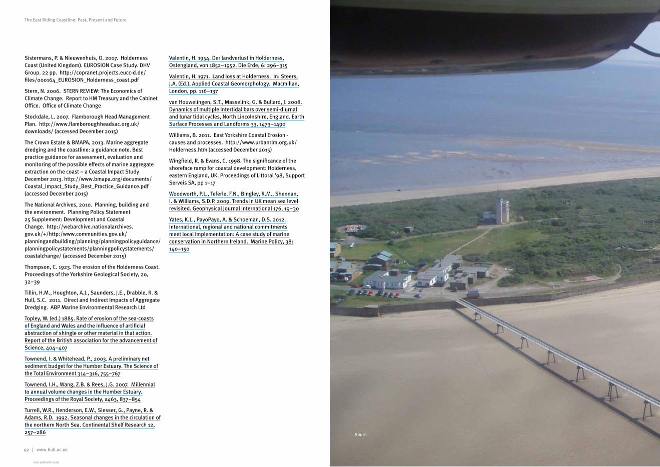
92 | www.hull.ac.uk www.hull.ac.uk | 93
The East Riding Coastline: Past, Present and Future The East Riding Coastline: Past, Present and Future
Sistermans, P. & Nieuwenhuis, O. 2007. Holderness Coast (United Kingdom). EUROSION Case Study. DHV Group. 22 pp. http://copranet.projects.eucc-d.de/files/000164_EUROSION_Holderness_coast.pdf
Stern, N. 2006. STERN REVIEW: The Economics of Climate Change. Report to HM Treasury and the Cabinet Office. Office of Climate Change
Stockdale, L. 2007. Flamborough Head Management Plan. http://www.flamboroughheadsac.org.uk/downloads/ (accessed December 2015)
The Crown Estate & BMAPA, 2013. Marine aggregate dredging and the coastline: a guidance note. Best practice guidance for assessment, evaluation and monitoring of the possible effects of marine aggregate extraction on the coast – a Coastal Impact Study December 2013. http://www.bmapa.org/documents/Coastal_Impact_Study_Best_Practice_Guidance.pdf (accessed December 2015)
The National Archives, 2010. Planning, building and the environment. Planning Policy Statement 25 Supplement: Development and Coastal Change. http://webarchive.nationalarchives.gov.uk/+/http:/www.communities.gov.uk/planningandbuilding/planning/planningpolicyguidance/planningpolicystatements/planningpolicystatements/coastalchange/ (accessed December 2015)
Thompson, C. 1923. The erosion of the Holderness Coast. Proceedings of the Yorkshire Geological Society, 20, 32–39
Tillin, H.M., Houghton, A.J., Saunders, J.E., Drabble, R. & Hull, S.C. 2011. Direct and Indirect Impacts of Aggregate Dredging. ABP Marine Environmental Research Ltd
Topley, W. (ed.) 1885. Rate of erosion of the sea-coasts of England and Wales and the influence of artificial abstraction of shingle or other material in that action. Report of the British association for the advancement of Science, 404–407
Townend, I. & Whitehead, P., 2003. A preliminary net sediment budget for the Humber Estuary. The Science of the Total Environment 314–316, 755–767
Townend, I.H., Wang, Z.B. & Rees, J.G. 2007. Millennial to annual volume changes in the Humber Estuary. Proceedings of the Royal Society, a463, 837–854
Turrell, W.R., Henderson, E.W., Slesser, G., Payne, R. & Adams, R.D. 1992. Seasonal changes in the circulation of the northern North Sea. Continental Shelf Research 12, 257–286
Valentin, H. 1954. Der landverlust in Holderness, Ostengland, von 1852–1952. Die Erde, 6: 296–315
Valentin, H. 1971. Land loss at Holderness. In: Steers, J.A. (Ed.), Applied Coastal Geomorphology. Macmillan, London, pp. 116–137
van Houwelingen, S.T., Masselink, G. & Bullard, J. 2008. Dynamics of multiple intertidal bars over semi-diurnal and lunar tidal cycles, North Lincolnshire, England. Earth Surface Processes and Landforms 33, 1473–1490
Williams, B. 2011. East Yorkshire Coastal Erosion - causes and processes. http://www.urbanrim.org.uk/Holderness.htm (accessed December 2015)
Wingfield, R. & Evans, C. 1998. The significance of the shoreface ramp for coastal development: Holderness, eastern England, UK. Proceedings of Littoral '98, Support Serveis SA, pp 1–17
Woodworth, P.L., Teferle, F.N., Bingley, R.M., Shennan, I. & Williams, S.D.P. 2009. Trends in UK mean sea level revisited. Geophysical Journal International 176, 19–30
Yates, K.L., PayoPayo, A. & Schoeman, D.S. 2012. International, regional and national commitments meet local implementation: A case study of marine conservation in Northern Ireland. Marine Policy, 38: 140–150
Spurn
View publication statsView publication stats