Embed Size (px)
Citation preview
THE EFFECT OF WINTER ANTICYCLONE TRACKS ON SURFACE WEATHER CONDITIONS IN NEW ORLEANS, LOUISIANA
Robert V. Rohli
Southern Regional Climate Center Department of Geography and Anthropology
Louisiana State University Baton Rouge, Louisiana
Abstract
The tracks of intense anticyclones over North America from the winters of 1960-61 to 1992-93 are classified as either curving east-northeastward into the Atlantic Ocean, or quasimeridional, in which the highs move toward and dissipate in the Gulf of Mexico. Muller's (1977) synoptic weather classification scheme is used to categorize atmospheric conditions at New Orleans on the day before, during, and after the anticyclone events. It isfound that, although the quasi-meridionally moving highs are less frequent than curving anticyclones, they are more likely to produce "Continental High" (CH) conditions in New Orleans, even though the difference in intensities of the two types of highs is insignificant. Also, the curving anticyclones arefound to produce CH weather in New Orleans from greater distances than quasi-meridional systems. Statistical tests reveal that the synoptic weather type and track type are interdependent on the day prior to, during, and after the nearest passage of the systems to New Orleans. Some physical explanations influencing these results are offered.
1. Introduction
One of the most significant mechanisms that produces cold air outbreaks in the southeastern United States is the surface anticyclone. More specifically, cases of intense, winter surface anticyclogenesis seem to play an especially important role in the creation of polar outbreaks in this region (Colucci and Davenport 1987). The trajectory of the surface high pressure system plays a major role in determining the degree of severity of the cold wave at a particular location (Rogers and Rohli 1991). An understanding of the behavior of these anticyclones and the weather patterns that they produce is important because of their tremendous impact on agriculture, energy consumption, and other human activities.
This study analyzes the relationship between the trajectories of various historical winter anticyclones in the southeastern United States and the circulation-based weather type around New Orleans, Louisiana before, during, and after the events. The results may provide forecasters with additional information to rely upon when making a subjective forecast for a localized area such as the central Gulf Coast. This could help compensate for weaknesses in the regional- and local-scale output of physically-based atmospheric models. Although such models have only limited success at local scales due to their coarse spatial resolution, inaccuracies associated with initial conditions, incomplete theoretical understanding, and inadequate parameterizations, they are relatively successful at predicting the generalized tracks of prominent features such as intense winter anticyclones. Thus, the general anticyclone path type can be forecasted by prognostic model output, and statistics can be used
2
to relate the track type to the regional- and local-scale weather types in and around New Orleans.
2. Winter Anticyclones and Weather Patterns
a. Importance of anticyclone research Although the relevance of anticyclones in causing circulation
changes such as polar outbreaks is recognized (Colucci and Davenport 1987), winter anticyclones have only recently received a significant amount of attention. Harman (1987) noted that this is unfortunate, since anticyclone paths are very responsive to adjustments in planetary flow, and because changes in anticyclone climatology may playa role in long-term temperature and precipitation changes. Bodurtha (1952) acknowledged that the cold anticyclone is less likely than its warm counterpart to have been born in a case of strong, rapid anticyclogenesis. Nevertheless, when a cold high is produced in this way its effects are often felt on the synoptic scale. Although many studies have considered cyclone frequencies (Hosler and Gamage 1956; Klein 1957; Reitan 1974; Colucci 1976) and tracks (Klein 1957; Parker et al. 1989) and cyclogenesis (Reitan 1974; Colucci 1985), few have addressed the role of anticyclones in producing anomalously cold conditions.
b. Path The path of a winter anticyclone is one of its most obviously
identifiable and important attributes. In his computation of the mean direction of surface anticyclone motion, Loomis (1876) completed the first study on anticyclones in the U.S. (Klein 1957). Since then, anticyclone paths have been analyzed by Brounov (1886), van Bebber (1894), and Rawson (1898) for various regions of the world, and by Bowie and Weightman (1917), Miller (1932), Berry et al. (1952), and Wasko (1954) for the U.S. (Klein 1957). The classical study of anticyclone tracks was conducted by Klein (1957), who undertook a comprehensive evaluation of frequencies and tracks of anticyclones for every month over periods of many years.
As is the case with anticyclones of other seasons, winter highs typically move to the east and southeast in the Northern hemisphere, with those crossing North America tending to dissipate along the Atlantic coast of the U.S. (Zishka and Smith 1980; Harman 1987). The upper level support for this mean track over North America is provided by frequent upper level ridging over western North America with the surface anticyclone migrating beneath the downstream side of the ridge. The supergeostrophic flow at ridges and subgeostrophic flow at troughs allows for upper level convergence between ridge and downstream trough which encourages the formation of surface divergence and surface anticyclone passage on the eastern side of the upper level ridge. The result is frequent southeastward
Volume 19 Number 3 March, 1995
movement of surface anticyclones in winter across the Great Plains and into eastern North America.
One interesting characteristic of the tracks of winter anticyclones that do not reach the southeastern U.S. is their tendency to divide into two anticyclones around the Great Lakes, in response to the near-surface heating by the Lakes (Harman 1987). This tendency of avoidance of warmer surfaces is manifested in the tendency of winter highs to curve sharply northeastward before reaching the warm waters of the Gulf of Mexico, since heating over the warm water provides a local source of cyclonic vorticity (Klein 1957).
It is recognized that there are two broad categories of North American winter anticyclones based on their paths (Klein 1957; Dallavalle and Bosart 1975). The first group (hereafter referred to as Type I) has generalized trajectories through Montana and the Dakotas before curving east-northeastward through the Corn Belt states and moving into the Atlantic Ocean (Dallavalle and Bosart 1975). Interestingly, these highs tend to ridge up along the U.S. east coast during a period of intense dynamic anticyclogenesis . Colucci and Davenport (1987) recognized several similar reintensification events along the Atlantic coast. In an early study, Bennett (1917) found that freezing temperatures at Tampa, Florida were most likely to be associated with a cyclone moving north-northeastward up the coast accompanied by a strong high with a track of this type.
Anticyclones of the second category (Type II) generally traverse the Wheat Belt states before dissipating in the Gulf of Mexico (Dallavalle and Bosart 1975). These systems move faster than the first set, and have little tendency for undergoing warm anticyclogenesis (Dallavalle and Bosart 1975). Brennan and Smith (1978) found similar groups of winter anticyclone paths across the Midwestern United States.
3. Research Objective
This research examines the differences between the synoptic weather patterns at New Orleans associated with the two major anticyclone tracks, and analyzes whether the frequencies of different synoptic types are statistically dependent upon the proximity of the anticyclonic centers. An improved understanding of the nature of these differences may enable forecasters to use both their intuition and prognostic models of probable anticyclone paths at the synoptic scale to facilitate the 48- to 72-hour prediction of regional scale weather patterns in New Orleans and the surrounding environs.
4. Data and Methods
a. Anticyclones Maps from the U.S. Weather Bureau ' s Daily Synoptic Series
spanning the winters (December through February) of 1960-61 to 1992-93 were used to find anticyclones which had penetrated into the central U.S. and had followed one of the generalized tracks described by Dallavalle and Bosart (1975) . To be included in the study, the anticyclone had to have two closed isobars and a pressure exceeding 103 kPa by the time it reached the northern Great Plains. The maximum central pressure and its general location, date of occurrence, track type, and the daily sequence of synoptic weather types at New Orleans during the passage of each anticyclone across North America were recorded.
b. Synoptic weather classification Muller's (1977) manual synoptic weather classification
scheme for New Orleans was used to classify atmospheric
3
conditions at New Orleans on the days before, during, and after the anticyclone passed nearest to the city. Manual techniques such as these were found to compare favorably with the automated techniques of correlation-based map patterns, eigenvector-based synoptic typing, and eigenvector-based map pattern analysis (Yarnal 1993). In Muller' s system, there are eight synoptic-scale features that can dominate New Orleans' weather, but one type, the Gulf Tropical Disturbance, does not occur during winter months .
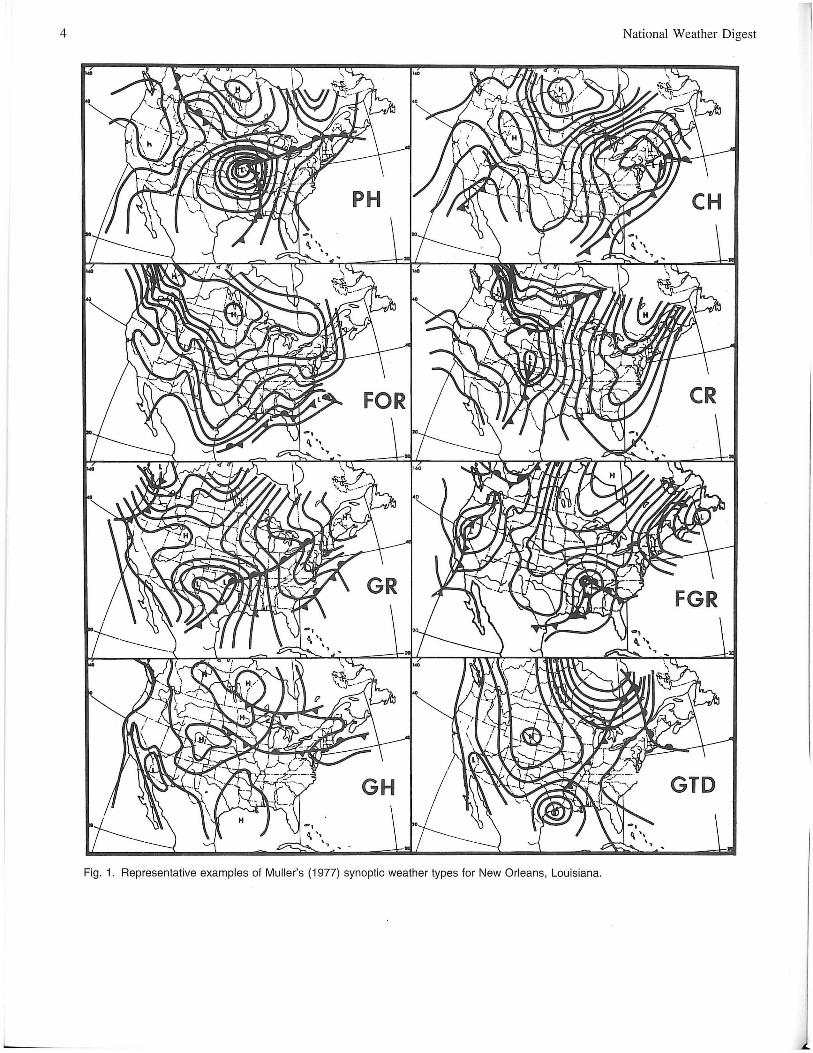
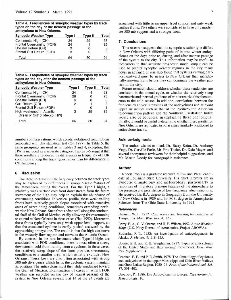
Table 1 characterizes the various weather types that can be associated with winter anticyclones, and examples of these types are shown in Fig. 1. Of special importance is the' 'Continental High" (CH) type, which is considered to be an indicator of the influence of the high at New Orleans. Statistical tests were used to test the general hypothesis relating track type of intense winter anticyclones in North America and New Orleans' weather.
Table 1. Major characteristics of Muller's (1977) Weather Types.
Weather Type
Pacific High (PH)
Continental High (CH)
Frontal Overrunning (FOR)
Coastal Return (CR)
Gulf Return (GR)
Frontal Gulf Return (FGR)
Gulf High (GH)
Gulf Tropical Disturbance (GTD)
Major Characteristics
Circulation around a deep surface low in the central U.S. brings mild and relatively dry air across southern Louisiana following a Pacific cold front
Southward flow of surface air east of the Rockies and over the Great Plains and Mississippi River Valley to Louisiana produces fair weather with few or no clouds and below normal temperatures, associated with the core of the high pressure system
Cold front becomes quasi-stationary along the Gulf Coast or over the northern or central Gulf of Mexico, producing overcast conditions in New Orleans
Anticyclonic ridge drifts to the east of Louisiana, and surface winds over New Orleans veer from northeast to east and southeast
Ridge drifts even farther eastward than for CR, and the pressure field on the western side of the high causes a strong return flow of maritime tropical air northward to New Orleans
Return flow is affected by lifting and convergence along an approaching cold front from the northwest, creating a turbulent and stormy situation in New Orleans
High pressure system in the Gulf of Mexico dominates weather in New Orleans by creating a southwesterly flow
Tropical systems ranging from weak easterly waves to severe hurricanes produce instability through deep moist layers
4 National Weather Digest l
GTD
Fig. 1. Representative examples of Muller's (1977) synoptic weather types for New Orleans, Louisiana.
L
Volume 19 Number 3 March, 1995
c. Justifications and limitations The period of 1960-61 to 1992-93 was chosen because it
represents the beginning of a twice-daily (0600 and 1500 LST) calendar of synoptic weather types for New Orleans continuously updated by Muller (1977). Coincidentally, the beginning of this time period also falls near the reestablishment of cooler winters in the Southeast (Leathers and Palecki 1992). There is another reason besides easy data access that New Orleans was chosen as the focal point of this study . As a representative of the humid subtropical climate of the Gulf Coast, which is found from central Texas to the Atlantic Ocean, New Orleans is in the zone of alternating influence of maritime tropical and continental polar winter air masses . This makes it an ideal place to assess the degree of influence of winter midlatitude synoptic systems in the sUbtropics.
There are cautions associated with this methodology. First, an inherent subjectivity is involved in the classification of synoptic weather types . However, this problem is minimized in that the same observer has analyzed all maps, which helps to maintain consistency in the weather typing. Since the phenomena of interest are intense systems OCCUlTing during winter, when there are strong thermal contrasts between systems, ambiguity of weather types is minimized. However, the range of conditions among cases of the same generalized track type should also be noted. Unfortunately, the coarse temporal resolution (oncedaily) of the synoptic maps prohibits precise tracking of the anticyclone paths. Comparison of conditions across the study period is further complicated because the daily weather maps were compiled at midnight until 1967-68 and from that point forward at 0600 CST. This complication is minimized by disregarding diurnally oscillating wind patterns occurring in New Orleans when classifying its synoptic weather type. These inaccuracies invite caution in the evaluation of storm tracks and weather types and in the interpretation of statistical results.
5. Results
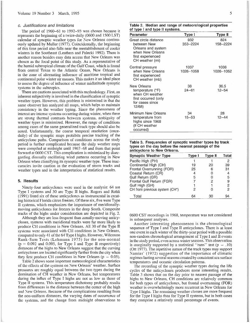
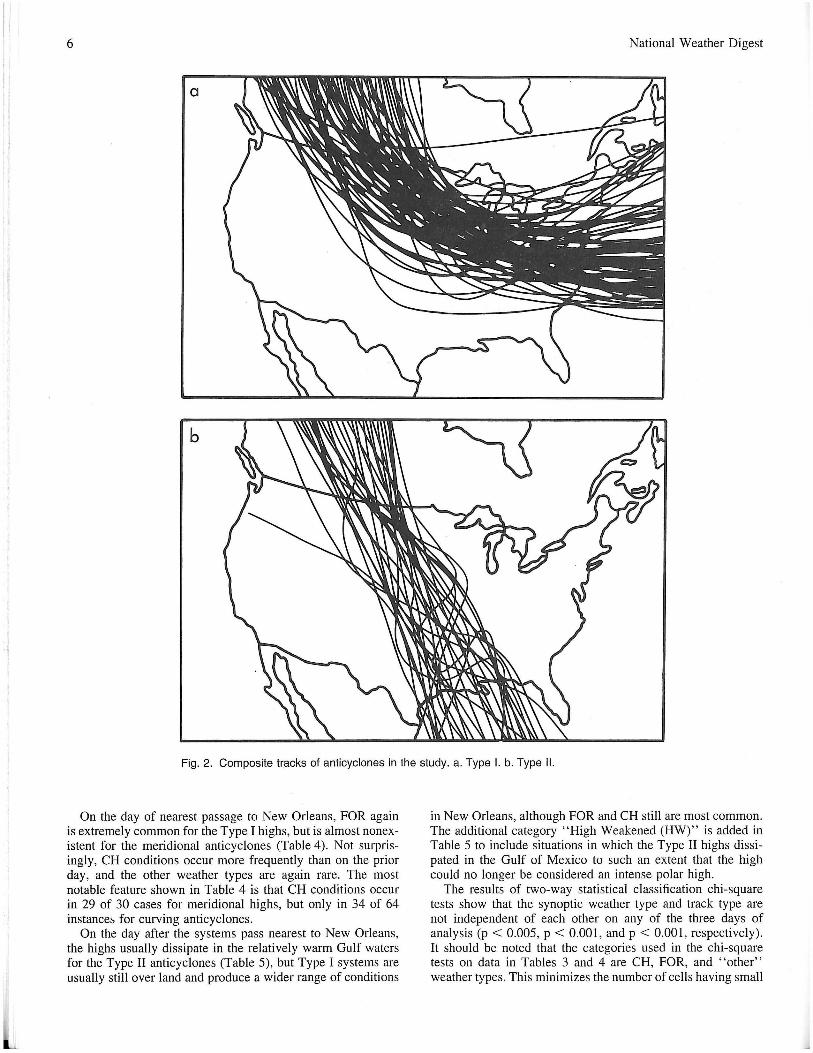
Ninety-four anticyclones were used in the analysis: 64 are Type I systems and 30 are Type II highs. Rogers and Rohli (1991) listed six of these anticyclones as instrumental in creating historical Florida citrus freezes . Of these six, fi ve were Type II systems, which emphasizes the importance of meridionallymoving anticyclones for freezes in the deep South. Composite tracks of the highs under consideration are depicted in Fig. 2.
Although they are less frequent than zonally-moving anticyclones, systems with meridional tracks were far more likely to produce CH conditions in New Orleans. All 30 of the Type II systems were associated with CH conditions in New Orleans, compared to only 41 of the 64 Type I highs. However, Wilcoxon Rank-Sum Tests (Lehmann 1975) for the non-normal (p = 0.092 and 0.095, for Type I and Type II respectively) distances of the highs to New Orleans suggest that the curving anticyclones are located significantly farther froin the city when they first produce CH conditions in New Orleans (p = 0.05).
Table 2 shows some important meteorological characteristics of the effects of the systems on New Orleans ' weather. Surface pressures are roughly equal between the two types during the domination of CH weather in New Orleans, but temperatures during the influx of Type I highs are not as low as those of Type II systems. This temperature dichotomy probably results from differences in the distance between the center of the high and New Orleans. Because of the complications resulting from the non-uniform distances, the varying dates of occurrence of the systems, and the change from midnight observations to
5
Table 2. Median and range of meteorological properties of type I and type II systems.
Parameter
Great circle distance between New Orleans and system when New Orleans first experienced CH weather (mi)
Central pressure when New Orleans first experienced CH weather (mb)
New Orleans temperature (OF) when CH weather first occurred (only for cases since 12/68)
Minimum New Orleans temperature from highs since 1968 (if CH weather occurred)
Type I
932 353-2224
1037 1026-1058
38 24-61
34 15-53
Type II
824 158-2224
1036 1026-1052
36.5 12-54
28 12-44
Table 3. Frequencies of synoptic weather types by track types on the day before the nearest passage of the anticyclone to New Orleans.
Synoptic Weather Type
Pacific High (PH) Continental High (CH) Frontal Overrunning (FOR) Coastal Return (CR) Gulf Return (GR) Frontal Gulf Return (FGR) Gulf High (GH) CH from previous system (CH*)
Total
Type I
1 19 25
4 5 7 1 2
64
Type II
1 20
6 o o 2 1 o
30
Total
2 39 31
4 5 9 2 2
94
0600 CST recordings in 1968, temperature was not considered in subsequent analyses.
Another interesting phenomenon is the chronological sequence of Type I and Type II anticyclones. There is at least one event in each winter of the thirty-year period with a possible non-random chronological arrangement of Type I and II events in the study period, even across winter seasons. This observation is marginally supported by a statistical "runs" test (p = .10) (Ott 1977). The repetitive nature of the track types may support N amias ' (1972) suggestion of the importance of climatic regimes lasting several seasons created by consistent sea surface temperatures and oceanic circulation patterns.
The recording of the synoptic weather types during the life cycles of the anticyclones produces some interesting results. Table 3 shows that on the day prior to nearest passage of the highs to New Orleans, CH conditions are relatively common for both types of anticyclones, but frontal overrunning (FOR) weather is overwhelmingly more recurrent in New Orleans for Type I highs. The remaining weather classes are more frequent for the Type I highs than for Type II systems, but in both cases they comprise a relatively small percentage of events.
I· 6 National Weather Digest
a
b
Fig. 2. Composite tracks of anticyclones in the study. a. Type I. b. Type II.
On the day of nearest passage to New Orleans, FOR again is extremely common for the Type I highs, but is almost nonexistent for the meridional anticyclones (Table 4). Not surprisingly, CH conditions occur more frequently than on the prior day, and the other weather types are again rare. The most notable feature shown in Table 4 is that CH conditions occur in 29 of 30 cases for meridional highs, but only in 34 of 64 instance::. for curving anticyclones.
On the day after the systems pass nearest to New Orleans, the highs usually dissipate in the relatively warm Gulf waters for the Type II anticyclones (Table 5), but Type I systems are usually still over land and produce a wider range of conditions
in New Orleans, although FOR and CH still are most common. The additional category "High Weakened (HW)" is added in Table 5 to include situations in which the Type II highs dissipated in the Gulf of Mexico to such an extent that the high could no longer be considered an intense polar high.
The results of two-way statistical classification chi-square tests show that the synoptic weather type and track type are not independent of each other on any of the three days of analysis (p < 0.005, P < 0.001, and p < 0.001, respectively). It should be noted that the categories used in the chi-square tests on data in Tables 3 and 4 are CH, FOR, and "other" weather types. This minimizes the number of cells having small
Volume 19 Number 3 March, 1995
Table 4. Frequencies of synoptic weather types by track types on the day of the nearest passage of the anticyclone to New Orleans. Synoptic Weather Type
Continental High (CH) Frontal Overrunning (FOR) Coastal Return (CR) Frontal Gulf Return (FGR)
Total
Type I
34 24
3 3
64
Type II 29
1 o o
30
Total
63 25
3 3
94
Table 5. Frequencies of synoptic weather types by track types on the day after the nearest passage of the anticyclone to New Orleans.
Synoptic Weather Type Continental High (CH) Frontal Overrunning (FOR) Coastal Return (CR) Gulf Return (GR) Frontal Gulf Return (FGR) High weakened in Atlantic
Ocean or Gulf of Mexico (HW)
Total
Type I
24 28
6 2 1 3
64
Type II 4 o o 1 o
25
30
Total
28 28
6 3 1
28
94
numbers of observations, which avoids violation of assumptions associated with this statistical test (Ott 1977). In Table 5, the same groupings are used as in Tables 3 and 4, excepting that HW is included as a separate category. Tables 3-5 suggest that these results are produced by differences in frequency of FOR conditions among the track types rather than by differences in CH frequency.
6. Discussion
The large contrast in FOR frequency between the track types may be explained by differences in synoptic-scale features of the atmosphere during the events. For the Type I highs, a relatively weak surface cold front downstream from the future movement of the high may help to explain the abundance of overrunning conditions. In vertical profile, these weak trailing fronts have relatively gentle slopes associated with extensive areas of overrunning conditions, sometimes extending northward to New Orleans. Such fronts often stall along the continental shelf of the Gulf of Mexico, easily allowing for overrunning to extend to New Orleans in these cases (Hsu 1992). Moreover, these fronts typically have only weak upper level support, so that the associated cyclone is easily pushed eastward by the approaching anticyclone. The result is that the high can move in the westerly flow regime and curve to the Atlantic Ocean.
By contrast, in the rare instances when Type II highs are associated with FOR conditions, there is most often a strong downstream cold front trailing from a cyclone. In these cases, the relatively steep slope of the front provides overrunning conditions to a smaller area, which usually excludes New Orleans. These lows are also often associated with strong 500-mb divergence which helps the cyclonic system maintain its position. The anticyclone must then slide southward toward the Gulf of Mexico . Examination of cases in which FOR weather was recorded on the day of nearest passage of the system to New Orleans reveals that 14 of the 24 events are
7
associated with little or no upper level support and only weak surface fronts. Five others were considered to have only moderate 500-mb support and a stronger front.
7. Conclusions
This research suggests that the synoptic weather type differs in New Orleans with differing paths of intense winter anticyclones on the days prior to, during, and after nearest passage of the system to the city. This information may be useful to forecasters in that accurate prognostic model output can be used to predict synoptic weather regimes in the city many hours in advance. It was also found that systems curving eastnortheastward must be nearer to New Orleans than meridionally-moving highs before they can dominate the weather pattern in the city.
Future research should address whether these tendencies are consistent in the annual cycle, or whether the relatively steep barometric and thermal gradients of winter restrict this phenomenon to the cold season. In addition, correlations between the frequencies and/or intensities of the anticyclones and relevant upper air indices such as that of the Pacific/North American teleconnection pattern and the Southern Oscillation Index would also be beneficial in explaining these phenomena . Finally, it would be useful to determine whether these results for New Orleans are replicated in other cities similarly positioned to anticyclone tracks.
Acknowledgments
The author wishes to thank Dr. Barry Keim, Dr. Anthony Vega, Dr. Carville Earle, Mr. Eric Thaler, Dr. Dale Meyer, and several anonymous reviewers for their helpful suggestions, and Mr. Martin Doody for cartographic assistance.
Author
Robert Rohli is a graduate research fellow and Ph.D. candidate at Louisiana State University. His chief interests are in synoptic climatology and meteorology, particularly in responses of migratory pressure features of the atmosphere to the presence and persistence of low-frequency teleconnections. He received his B.A. degree in Geography from the University of New Orleans in 1989 and his M.S. degree in Atmospheric Sciences from The Ohio State University in 199 I.
References
Bennett, W. J., 1917: Cold waves and freezing temperatures at Tampa, Fla. Mon. Wea. Rev. 4, 123.
Berry, F. A., G. V. Owens, and H. P. Wilson, 1952: Arctic Weather Maps (U.S. Navy Bureau of Aeronautics, Project AROWA).
Bodurtha, F. T., 1952: An investigation of anticyclogenesis in Alaska. 1. Meteor. 9, 118-125.
Bowie, E. H. and R. H. Weightman, 1917: Types of anticyclones of the United States and their average movements. Mon. Wea. Rev. Supplement, 4.
Brennan, F. E. and P. E. Smith, 1978: The climatology of cyclones and anticyclones in the upper Mississippi and Ohio River Valleys and Great Lakes Region, 1950-74. Proc. oj the Indiana Acad. Sci. 87, 391-402.
Brounov, P., 1886: Die Anticyclonen in Europa. Repertoriumjur Meteorologie, 10.
8
Colucci, S. 1. , 1976: Winter cyclone frequencies over the eastern United States and adjacent western Atlantic 1964-1973. Bull. Amer. Meteor. Soc. 57, 548-553.
_______ , 1985: Explosive cyclogenesis and large-scale circulation changes: Implications for atmospheric blocking. J. Atmos. Sci., 42, 2701-2717.
_______ and 1. C. Davenport, 1987. Rapid surface anticyclogenesis: Synoptic climatology and attendant large-scale circulation changes. Mon. Wea. Rev. 115, 822-836.
Dallavalle, 1. P. and L. F. Bosart, 1975: A synoptic investigation of anticyclogenesis accompanying North American polar air outbreaks. Mon. Wea. Rev. 103, 941-957.
Harman, J. R., 1987: Mean monthly North American anticyclone frequencies . 1950-79, Mon. Wea. Rev. 115, 2840-2848.
Hosler, C. L. and L. A. Gamage, 1956: Cyclone frequencies in the United States for the period 1905-1954. Mon. Wea. Rev. 84, 388-390.
Hsu, S.-A. , 1992: Effects of surface baroclinicity on frontal overrunning along the central Gulf Coast. J. Appl. Meteor. 31,900-907.
Klein, W . H., 1957: Principal tracks and mean frequencies of cyclones and anticyclones in the Northern Hemisphere. Weather Bureau Research Paper No. 40 (Washington, U.S. Dept. of Commerce, NOAA).
Leathers, D. J. and M. A. Palecki, 1992: The PacificlNorth American teleconnection pattern and United States climate. Part II: Temporal characteristics and index specification. J. Climate 5: 707-716.
Lehmann, E. L., 1975: Nonparametrics: Statistical Methods Based on Ranks. Holden-Day. 457 pp.
Loomis, E., 1876: Contributions to meteorology , being results derived from an examination of the United States weather maps and from other sources. Amer. 1. Science and Arts II, 1-17.
National Weather Digest
Miller, E. R. , 1932: Relative frequency of centers of cyclones and anticyclones in the United States. Mon. Wea. Rev. 60, 6-11.
Muller, R. A. , 1977: A synoptic climatology for environmental baseline analysis: New Orleans. J. Appl. Meteor. 16, 20-33.
Namias, J., 1972: Experiments in objectively predicting some atmospheric and oceanic variables for the winter of 1971 - 72. J. Appl. Meteor. II, 1164-1174.
Ott, L., 1977: An Introduction to Statistical Methods and Data Analysis. Duxbury Press. 730 pp.
Parker, S. S. , 1. H. Hawes, S. J. Colucci, and B. P. Hayden, 1989: Climatology of 500-mb cyclones and anticyclones, 1950-85. Mon. Wea. Rev. 117,558-570.
Rawson, H. E., 1898: Anticyclonic systems and their movements . Quart. J. Royal Meteor. Soc. 24, 180-203.
Reitan, C. H., 1974: Frequencies of cyclones and cyclogenesis for North America, 1951-1970. Mon. Wea. Rev. 102,861-868.
Rogers, J. C. and R. V. Rohli , 1991 : Florida citrus freezes and polar anticyclones in the Great Plains. J. Climate 4, 1103-1113.
van Bebber, W. J., 1894: Haufigkeit und Tiefe der Barometrischen Minima Sowie Bahnen der Maxima und Stationare Maxima in dem Zeitraum vom Winter 1883/84 Bis End Herbst 1887. Annalen del' Hydrographie und Maritimen Meteorologie 22, 208-218.
Wasko, P. E., 1954: Pressure and temperature variations over the centers of typical migratory anticyclones. Bull. Amer. Meteor. Soc. 35, 26-32.
Yarnal, B., 1993: Synoptic Climatology in Environmental Analysis. Belhaven Press Inc. 195 pp.
Zishka, K. M. and P. J. Smith, 1980: The climatology of cyclones and anticyclones over North America and surrounding ocean environs forJanuary and July, 1950-77. Man. Wea. Rev. 108,387-401.
1D l£~RS -'0 .Ihe~m~akina ... Nobody knows weather's humorous , side better than Norm Dvoskin,
author of American Weather Observer's monthly Weather Wit column. Now, he's assembled ten
plus $200 postage, tax, and handling
Send order to: Weather Wit American Weather Observer 401 Whitney Blvd.
years of his best weather anec-dotes and one-liners in this new softbound book. Eighty pages of weather lines that will find you laughing all by yourself, or, better yet, provide some great material for you to share with those who know of your own fascination in weather.
Belvidere, illinois 61008-3772 Norm Dvoskin Make checks payable to American Weather Observer