Embed Size (px)
Citation preview

This article was downloaded by: [Evan Laksmana]On: 26 July 2011, At: 10:19Publisher: RoutledgeInforma Ltd Registered in England and Wales Registered Number: 1072954 Registeredoffice: Mortimer House, 37-41 Mortimer Street, London W1T 3JH, UK
Journal of the Indian Ocean RegionPublication details, including instructions for authors andsubscription information:http://www.tandfonline.com/loi/rior20
The enduring strategic trinity:explaining Indonesia's geopoliticalarchitectureEvan A. Laksmana aa Centre for Strategic and International Studies and IndonesianDefense University, Jakarta
Available online: 26 Jul 2011
To cite this article: Evan A. Laksmana (2011): The enduring strategic trinity: explaining Indonesia'sgeopolitical architecture, Journal of the Indian Ocean Region, 7:1, 95-116
To link to this article: http://dx.doi.org/10.1080/19480881.2011.587333
PLEASE SCROLL DOWN FOR ARTICLE
Full terms and conditions of use: http://www.tandfonline.com/page/terms-and-conditions
This article may be used for research, teaching and private study purposes. Anysubstantial or systematic reproduction, re-distribution, re-selling, loan, sub-licensing,systematic supply or distribution in any form to anyone is expressly forbidden.
The publisher does not give any warranty express or implied or make any representationthat the contents will be complete or accurate or up to date. The accuracy of anyinstructions, formulae and drug doses should be independently verified with primarysources. The publisher shall not be liable for any loss, actions, claims, proceedings,demand or costs or damages whatsoever or howsoever caused arising directly orindirectly in connection with or arising out of the use of this material.
The enduring strategic trinity: explaining Indonesia’s geopoliticalarchitecture
Evan A. Laksmana*
Centre for Strategic and International Studies and Indonesian Defense University, Jakarta
(Received 7 February 2010; final version received 25 April 2011)
This paper seeks to describe and assess the geopolitical architecture of Indonesiaas the largest archipelagic state in the world. It makes two main inter-relatedarguments. First, Indonesia’s geographical traits suggest that it could be both asource of weakness and vulnerability as much as it brings enormous potential forpolitical, economic, and even military power. Second, the historical origins andconceptual foundations of ‘geopolitics’ as a policy theme suggest that Indonesia’sgeopolitical architecture is based on three building blocks � the ‘strategic trinity’:geostrategy (the military and security dimensions), geoeconomics (the resourceand economic dimensions), and geopolitics (the social and political dimensions).While these arguments are not novel in themselves, this paper represents amongthe first attempts to systematically analyse and assess Indonesia’s geographicaltraits and how they shape the country’s strategic thinking, foreign policy, andnational security system. The paper will also consider how Indonesia’sgeopolitical architecture could help explain the country’s resurgent interest inthe Indian Ocean Region in recent years.
Keywords: archipelagic state; strategic trinity; geostrategy; geoeconomics;geopolitics
I. Introduction
This paper seeks to describe and assess the geopolitical architecture of Indonesia, the
largest country in Southeast Asia and the world’s largest archipelagic state.
Geopolitical architecture is generally seen as the ways in which states access, manage
and regulate the intersection of territories and flows, and, in so doing establish
borders between inside/outside and domestic/international (Dodds 2007, p. 55). The
long-established study of geopolitics, however, suggests that observers should not
only focus on the geographical dimension of a state’s security and foreign policy
(Spykman 1969, pp. 5�6), but also on the perceptions of the political and security
elite regarding the nature of their environment, or their ‘political�geographical
mental maps’ (Muir and Paddison 1981, p. 209). A geopolitical architecture,
therefore, must be understood to be broader than just the relationship between
spatial dimensions and politics. Instead, it needs to be seen within the historical
development of a state’s strategic thinking regarding the social, economic, cultural,
political and security dimensions of its geography.
*Email: [email protected]
Journal of the Indian Ocean Region
Vol. 7, No. 1, June 2011, 95�116
ISSN 1948-0881 print/1948-108X online
# 2011 Indian Ocean Research Group
DOI: 10.1080/19480881.2011.587333
http://www.tandfonline.com
Dow
nloa
ded
by [
Eva
n L
aksm
ana]
at 1
0:19
26
July
201
1

Assessing and understanding Indonesia’s geopolitical architecture is important
for two reasons. First and foremost is Indonesia’s ‘strategic centrality’ within the
Asia-Pacific region. Indonesia is not only abundant with natural resources such as oil
and gas, but the country is also located in the middle of the ‘cross-roads’ between the
Indian and Pacific Oceans and between the Asian and Australian continents. It also
controls four of the world’s seven major maritime chokepoints, including the
Malacca Strait. This further suggests that the economic, political and military lifelineof the Asia-Pacific region and its major powers � the United States, India, Australia,
China, Japan � depends on the stability, foreign policy and geopolitical thinking in
Jakarta.
Secondly, while there are numerous studies on Indonesia’s strategic thinking,
foreign policy and national security system (for example, Weinstein 1976; Sebastian
2006; Novotny 2010), these discussions rarely address or consider the country’s
geographical traits as a significant explanatory variable. One exception was the work
of Djalal (1996), written over a decade ago, regarding Indonesia’s geopolitical
thinking and history in relation to its maritime territorial behaviour. This work,
however, is not only in need of revision with new materials, but it is focused more on
the maritime domain and less on the larger strategic picture of Indonesia’s
geopolitical architecture. Other scattered works on the country’s geopolitics have
relatively been more of a policy snapshot rather than a systematic assessment (for
example, Alfandi 2002; Anggoro 2006).This paper makes two main interrelated arguments. First, Indonesia’s geogra-
phical traits as the largest archipelagic state present an enduring paradox and
dilemma as they could be both a source of weakness and vulnerability as much as
they could bring enormous political, economic, and even military potential. This
argument confirms a long-held assumption that the geography of a state presents
both opportunities and limitations for that state, and therefore shapes and affects
its national security and foreign policy (for example, Sempa 2002). The present paper
will further show how this enduring paradox of weakness and strength shapes the
country’s force development, foreign policy, strategic thinking and even security
operations and assessments.
Second, the history and evolution of Indonesia’s ‘geopolitics’ as a policy practice
and theme (as opposed to a well-developed academic school of thought) suggests
that the country’s geopolitical architecture is defined and built over what this paper
calls the ‘strategic trinity’ � geostrategy (the military and security dimensions),
geoeconomics (the resource and economic dimensions) and geopolitics (the social
and political dimensions). While this argument is certainly not a novel one within thelarger literature on geopolitics, it does represent among the first attempts to
systematically spell out and assess the differing dimensions and implications of
Indonesia’s geographical traits.
By way of outline, this paper will first describe Indonesia’s basic geographical
traits as the largest archipelagic state in the world to understand the various
complexities and implications relating to the country’s strategic thinking, foreign
policy and national security system. The following section will discuss the historical
origins and conceptual foundations of Indonesia’s ‘geopolitics’ as practical policy
guidance for the country’s policy elite. Based on these two sections, the paper will
then assess the strategic trinity of Indonesia’s geopolitical architecture and detail how
they impact on the country’s foreign policy and national security system. Prior to a
96 E.A. Laksmana
Dow
nloa
ded
by [
Eva
n L
aksm
ana]
at 1
0:19
26
July
201
1

final conclusion, the penultimate section of the paper will also be devoted to
analysing Indonesia’s growing interest in the Indian Ocean Region in recent years
based on the previous sections.
2. Indonesia’s geographical traits
The Indonesian archipelago of 18,108 islands comprises 2.8 million square kilo-
metres of water (92,877 sq. km of inland waters), 1,826,440 square kilometres of
land, and if its exclusive economic zone (EEZ) is factored in, the country’s area
stretches to 7.9 million square kilometres (Cribb and Ford 2009, p. 1). However,
unlike other archipelagic states, Indonesia is a complex of archipelagos and large
islands with Java being the dominant one. The disparity between the islands in termsof population, political weight and economic development means that a convoluted
centre�periphery tension marks the country’s history. This will be further elaborated
in the following sections. For now, suffice it to say that Indonesia’s geographical
fragmentation coupled with the underlying centre�periphery tension underline the
country’s internal security problems and threats.
Indonesia also hosts four of the world’s seven major maritime choke points while
sitting between the Pacific and Indian Oceans and between the Asian and Australian
continents. As such, major powers have historically been drawn to and have takenconsiderable interest in the development of Indonesia as it could tip the regional
balance of power. Its bountiful natural resources such as petroleum, tin, natural gas,
nickel, timber, coal and copper further increases the country’s strategic value.
However, as the ‘expressions of interest’ by the major powers are not always
manifested in the most favourable terms for Jakarta, the country’s policymakers have
from time to time feel a sense of insecurity and fear of exploitation, often giving
urgency to control the country’s waterways and patrol the maritime domain.
In this regard, Indonesia’s predominant geographical trait as the largestarchipelagic state with thousands of islands creates huge complications over
maritime governance. Even after the 1982, the United Nations Convention on the
Law of the Sea (UNCLOS) and two Indonesian government regulations, Indonesia
still has differing levels of sovereignty and jurisdiction over the waters within and
outside its archipelagic baselines (Oegroseno 2009, p. 51). This layered jurisdiction
poses considerable challenges for the country’s management of its maritime domain,
especially since many of its maritime boundaries � with 10 countries, the most in the
world � have yet to be finally negotiated and demarcated.Thus, in essence, Indonesia’s geographical traits are characterised by: (1) a vast
maritime domain; (2) the prevalence of internal security, political and economic
problems on land; and (3) the persistence of major power rivalries in its regional
environment due to its strategic location. Yet, as will be discussed below, the last trait
of location has had the most significant imprint on the mental map of Indonesian
policymakers (Djalal 1996, p. 101). Indeed, assertions regarding Indonesia’s
historical journey, turbulent relations with the major powers, or regional leadership,
are often attributed to the ‘cross-road location’ (known as posisi silang) between theIndian and the Pacific Oceans and between the Asian and Australian continents.
Even the Indonesian term for ‘archipelago’ is Nusantara, a traditional Javanese
expression that means ‘situated between the islands’ (Djalal 1996, p. 107).
Mohammad Hatta, Indonesia’s first vice president and chief architect of its
Journal of the Indian Ocean Region 97
Dow
nloa
ded
by [
Eva
n L
aksm
ana]
at 1
0:19
26
July
201
1

independent and active foreign policy, further argued: ‘Nature has ordained that
Indonesia, lying between two continents � the Asian mainland and Australia � and
washed by the waters of two vast Oceans � the Indian and Pacific � must maintain
intercourse with lands stretching in a great circle around it’ (Hatta 1953, p. 450). Thisargument is still alive today and continues to resonate within the foreign policy elite
(Novotny 2010).
Indonesia’s geographical traits have two contradictory implications for its
geopolitical architecture. On the one hand, the vast maritime domain could become
a buffer surrounding the country and offering protection � and, if fully controlled,
could form a unified political, geographic, economic, social and security entity. In
theory, this should allow Indonesia to emerge as a major maritime power and
regional leader. However, on the other hand, the convoluted centre�peripheryrelations between Jakarta and the outer islands as well as the social/religious/
economic diversity of its people have led Indonesia’s policymakers to view geography
as a source of vulnerability and weakness.
3. Historical origins and conceptual foundations
As a geopolitical entity, ‘Indonesia’ did not exist before the completion in the
beginning of the twentieth century of a process of administrative and territorialconsolidation by the Dutch colonial authority (Sebastian 2006, p. 53). Before then,
the archipelago comprised separate kingdoms with a much more limited geographi-
cal and geopolitical space � many of which were ‘land-based’ or continental powers.
Except for several major kingdoms such as Majapahit (1293�1527) that ruled large
portions of the area, the entire Indonesian archipelago also never had a single long-
lasting major dynasty that expanded its influence beyond the borders. These
historical contexts had helped to sustain a ‘defensive land power’ strategic culture,
especially after the Dutch colonised the territory over three centuries (Anggoro 2006,p. 72�73). This is also among the reasons why, despite the country’s maritime nature
� as the following sections will show � Indonesia’s geopolitical thinking focuses on
internal security threats.
That said, it is not generally known precisely when and how the study and
concept of geopolitics first came to Indonesia. Anecdotal evidence suggests that the
invasion of the Japanese during World War II and the training of several Indonesian
officers in the Dutch military academy may have instilled the works of prominent
geopolitical theorists in the minds of Indonesia’s founding fathers. During the earlydays of the country’s independence, for example, some leaders uttered geopolitical
terms like ‘The Sphere of Greater East Asia’.1 One of them, Muhammad Yamin,
explicitly used the term ‘geopolitics’ in August 1945 when presenting his ideas for a
‘Greater Indonesia’ incorporating the territory of the Netherlands East Indies,
British Malaya and North Borneo, Portuguese East Timor and the Dutch West New
Guinea (Yamin 1970). General T.B. Simatupang, among the founding figures of the
Indonesian Armed Forces, and an avid reader of Clausewitz and Liddell-Hart
(Sebastian 2006, p. 62), was also well known for his fondness for the term‘geopolitics’.
However, for all of this seemingly familiarity with the concept, ‘geopolitics’ as a
distinct school of thought or theory was never systematically developed by
Indonesian scholars and policymakers. Instead, ‘geopolitics’ developed as a practical
98 E.A. Laksmana
Dow
nloa
ded
by [
Eva
n L
aksm
ana]
at 1
0:19
26
July
201
1

policy theme and political phrase with different specific interpretations from time to
time. But the idea of ‘geopolitics’ as the country’s foreign and security policy
foundation remains. As a political phrase, it was also often used in the speeches and
writings of the elite. This suggests that the dominant view of geopolitics then was to
treat the term as ‘practical themes’ (a set of underlying assumptions) rather than
‘academic theories’ (Djalal 1996, p. 101). This is also perhaps why Indonesia never
had a geopolitical theorist or doyen like Mahan or MacKinder, or a distinct
geopolitical school of thought.As a matter of practical national policy guidance, the earliest foundation of
modern Indonesia’s geopolitical architecture can be traced back to the period
between 1956 and 1960. It was during this period that the foreign policy and security
elite first started to systematically and seriously consider the country’s geography
arising out of concerns over foreign maritime passages within the archipelago (Djalal
1996, p. 18). Indeed, before and after declaring independence, the founding fathers
were apparently not urgently concerned with the country’s boundaries.2 Indeed, it
was not until 1956 that the government established the Inter-Departmental
Committee to systematically assess geopolitical issues pertaining to the country’s
maritime and territorial boundaries. Specifically, it was tasked with reviewing the
country’s 1939 Colonial Ordinance and preparing a draft on the Law on Indonesian
Territorial Waters and Maritime Environment (Danusaputro 1980, pp. 131�134).
The 1939 Ordinance formulated by the Netherlands � then the only regulatory
foundation of the country’s maritime and territorial boundary � stipulated that the
country’s sovereignty extended three miles from the low-water mark (Siahaan and
Suhendi 1989). This presented Jakarta with huge security challenges. Since distances
exceeding six miles separate most of its islands or island groups, the three-mile belts
could not contain the archipelago within a single jurisdictional blanket (Djalal 1996,
p. 20). Consequently, there were numerous fragments of territorial waters � most of
which consist of international waters or open seas � compartmentalising the islands.A Foreign Ministry publication notes that: ‘The presence of pockets of open sea
amongst [the islands] posed a grave danger to the security and territorial integrity of
Indonesia, since such a situation had given opportunities for external elements to
imperil Indonesia by way of those high seas to support local political unrests’
(MOFA 1986, p. 10).
Aside from this problem, there were other factors that drove the formation and
work of the Inter-Departmental Committee (Djalal 1996, p. 26�27), including the
increasing rise and significance of smuggling in the archipelago, the growing unrest
and rebellions in various regions, and the suspicion that there were ‘foreign maritime
activities’ with hostile intent, especially with regard to Dutch Naval activities in West
Irian.3 Given these conditions, a year into the Committee’s work, Prime Minister
Djuanda Kartawidjaja issued a declaration in 1957 that would later be known as the
Djuanda Declaration that shelved the 1939 ordinance:
The government declares that all waters surrounding, between and connecting theislands constituting the Indonesian state, regardless of their extension or breadth, areintegral parts of the territory of the Indonesian state and therefore, parts of the internalor national waters which are under the exclusive sovereignty of the Indonesian state . . .The delimitation of the territorial sea (the breadth of which is 12-misles) is measuredfrom baselines connecting the outermost points of the islands of Indonesia. (Cited inDjalal 1996, p. 29)
Journal of the Indian Ocean Region 99
Dow
nloa
ded
by [
Eva
n L
aksm
ana]
at 1
0:19
26
July
201
1

This declaration forms Indonesia’s first explicit policy to unify the archipelago
into a single entity and to ‘close off ’ its open seas. It also shapes the country’s
geopolitical architecture for decades by giving birth to what is now called the
‘Archipelago Doctrine’ or ‘Archipelagic State Concept’.4 Yet, two years were to pass
before the Djuanda Declaration would finally be ratified by parliament. Partly
because the elite had adopted a wait-and-see attitude with regard to the First UN
Conference on Law of the Sea (UNCLOS I) to test the doctrine’s conceptualcredibility (Djalal 1996, p. 36), and partly because other maritime powers, especially
the United States, Britain and Australia, expressed strong opposition. Indonesia
would only later be successful in having the doctrine accepted into international law
by the third UNCLOS (UNCLOS III) in1982.5
The Djuanda Declaration was nonetheless enacted as Act No. 4 of 1960, which
formalised a new territorial structure by expanding Indonesia’s overall national
territory by about 2.5 fold from 2.02 million square kilometres to 5.19 million square
kilometres. More importantly, the new territorial configuration consisted of 196
straight baselines, forming a circumference surrounding the Indonesian islands which
amounted to over 8000 nautical miles in length (Kusumaatmadja 1982, p. 22).
Jakarta also issued the Act on Innocent Passage in 1962 as a corollary regulation that
deals with navigational conduct and establishes operational criteria to determine the
‘innocent’ character of maritime passage within Indonesia’s waters.6
However, the period of President Sukarno’s Old Order (1959 to 1965) never saw aserious attempt to take the Djuanda Declaration and two enacted laws further.
Instead, President Sukarno was more interested in abstract political slogans than
practical policy. Also, the military as among the key proponents of the Archipelagic
Doctrine, was too plagued with inter-service rivalry and factionalism to keep the
matter alive and well in the minds of the Cabinet. Finally, the legal uncertainty of the
Archipelagic Doctrine under international law had also contributed to the lethargic
attitude among domestic policymakers (Djalal 1996, p. 57). This trend would later be
reversed under the New Order of President Suharto (from 1965 to 1998).
Under the New Order, the Djuanda Declaration and territorial maritime issues
were revived and specifically formulated. Indeed, the new elite proceeded to expand
the country’s maritime jurisdictions by claiming the continental shelf areas outside
the archipelagic borders in 1969 and announced its Exclusive Economic Zones in
1981. Jakarta also spent enormous political and diplomatic capital to obtain
maritime border treaties with neighbouring countries (totalling 12 with six countries
by 1980) as well as fighting for the acknowledgement of the Archipelagic State
concept in UNCLOS and other forums. But most importantly, the birth ofthe doctrine of ‘Archipelagic Outlook’ (Wawasan Nusantara) in 1966 marked the
restructuring and revitalisation of Indonesia’s geopolitical thinking. It should also be
noted that the rise of the Indonesian Armed Forces (ABRI) at the expense of
the Indonesian Communist Party (PKI) in 1965, helped pave the way for the rise of
the geopolitical orientation in the late 1960s.7
In November 1966, a seminar organised by the Department of Defence and
Security produced the Doctrine on National Defence and Security and the Doctrine
of the Struggle of the Armed Forces. Both argued for the first time that Indonesia’s
defence and security doctrine, in its practical sense, would be the Maritime
Archipelagic Outlook (Wawasan Nusantara Bahari): ‘an outlook of the nation’s
worldview, where the utilization and mastery of the sea is an absolute necessity to
100 E.A. Laksmana
Dow
nloa
ded
by [
Eva
n L
aksm
ana]
at 1
0:19
26
July
201
1

enhance national prosperity and glory’ (Hardjosoedarmo 1981, p. 178). Although a
revised version of the doctrine deleted the word ‘maritime’ from the title, it still
represented an attempt by the new military�political elite to create a new conceptual
framework for defence and foreign and security policy rooted in the country’sgeographical character.
This development also had the effect of formalising the notion that geography is a
‘strategic’ arena where the ‘whole entity of land and water becomes a single strategic
defence system’ (Kroef 1976, p. 482). As it began to take greater significance after
ABRI’s endorsement, a revised version of the Archipelagic Outlook was submitted in
1972 to parliament and became part of the 5-year National Policy Guidelines. By
1973, the geopolitically-oriented outlook was thus elevated from a defence doctrine
to a political doctrine (Djalal 1996, p. 66). The unintended consequence of thiselevation, however, was the increasingly blurred geographical dimension of the
doctrine as economic, social and political considerations started to feature more
prominently.
Thus, the Archipelagic Outlook dominated the country’s geopolitical thinking
during the New Order. Former Armed Forces Commander, M. Panggabean (1982),
p. 34), even stated that the Archipelagic Outlook is ‘the geopolitics of Indonesia’.
Others believed that the Outlook is ‘a geopolitical conception which is uniquely
Indonesian’ (Soebroto, Sunardi and Wahyono 1983, p. 60). The Outlook in essenceaimed to provide coherence to the country’s fragmented geography while linking land
and sea to provide a metaphor unifying the disparate socio-economic-political
groupings into a single unified entity (Lowry 1996). Over time, four main themes
emerged out of this conception (Djalal 1996, p. 101): (1) an enduring concern over
geographical location; (2) a suspicion toward extra-regional powers; (3) an aspiration
for regional activism and leadership; and (4) a concern over national unity in the
wake of fragmented geography. As the following sections will show, the interplay of
these four main themes continues to resonate in the minds of the policymakers today.To sum up, this section has shown how the country’s geopolitical architecture is
largely defined as the ongoing effort to both address the country’s fragile and
vulnerable state structure as well as the marshalling of national resources to defend
the state as a unified geographical, political, social, economic, and security entity.
The paper further submits that out of this conception three dominant themes or
building blocks are particularly germane: geostrategy (the military and security
dimensions), geoeconomics (the resource and economic dimensions) and geopolitics
(the social and political dimensions).
4. Geostrategy: the military and security dimensions
As the previous section shows, geopolitical thinking under the New Order was
elevated to new heights and sophistication � conceptually and politically. It was also
during this period that geopolitics, especially through the Archipelagic Outlook,
became the purview of the ‘strategic arena’. As such, the military�security
dimensions form the first building block of Indonesia’s geopolitical architecture. Inthis regard, the military first and foremost considers Indonesia’s crossroad location
as a source of vulnerability. Former Armed Forces Commander, Benny Moerdani,
noted: ‘The threat which endangers the sovereignty of the republic comes not only
from the Northern area. Rather, danger would also come from all directions, be it
Journal of the Indian Ocean Region 101
Dow
nloa
ded
by [
Eva
n L
aksm
ana]
at 1
0:19
26
July
201
1
from the South, from the East, or from the West of the Nusantara Archipelago’
(cited in Djalal 1996, p. 109).However, paradoxically, some also saw Indonesia’s location as a potential source
of power and influence, provided that the country could exploit it, but this in turn
depends on the military’s ability to effectively control the maritime waterways. As
such, military theorists within the high command often argued for the critical need to
develop a defence system that would allow ‘the complete control of the islands, and
with the islands as strong points, establish the rule of the seas between and around
them’ (Suryohadiprodjo 1969, p. 233). This line of thinking continues to guide the
military’s doctrinal development until today (MoD 2010). Not least because it
provides the much-needed rationale to increase defence spending and sustain
military modernisation.
Yet, despite the inescapable conclusion that Indonesia’s maritime character and
doctrinal foundation should have led defence planners to focus on building and
sustaining a modernised, capable navy, the military (TNI) is paradoxically an army-
dominated institution (Rabasa and Haseman 2002, p. 9).8 Both the Air Force and
Navy have been historically charged with providing direct support to the Army.
Consequently, and given the enduring nature of internal security threats throughout
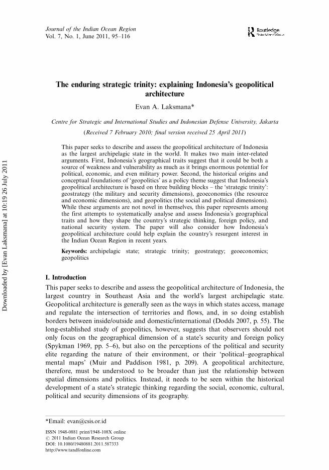
the country’s history (see Figure 1), the military as a whole and defence planners in
particular continue to focus on a ‘land-based defence’ (Widjajanto 2010). Another
by-product has been small budgets, ageing equipment, low number of personnel and
a relatively low general standing for the Navy (Dupont 1996).
Defence-in-depth has therefore been the preferred strategy for the military to
defend the archipelago. Strategically, according to former Armed Forces Comman-
der, Benny Moerdani, it talks about the comprehensive and broader aspects of
defence (ideological, socio-cultural, political) while recognising the importance of
‘regional resilience’ in Southeast Asia as a buffer for the country (Moerdani 1993,
p. 57). In today’s parlance, this ‘layered defence’ is interpreted as a system where the
TNI forms the core component of national defence, with the yet-to-be-formed
Reserve and Supporting Components, forming the second and third layer,
respectively (MoD 2008).
Figure 1. Indonesia’s enemy character (1945�2004).
Note: The figures provided on Indonesia’s internal security threats are taken from the
character (based on the types of the enemy) of 249 military operations undertaken by the
Armed Forces between 1945 and 2004.
Source: All figures are adapted from Widjajanto and Wardahani (2008).
102 E.A. Laksmana
Dow
nloa
ded
by [
Eva
n L
aksm
ana]
at 1
0:19
26
July
201
1
Operationally, this would be translated into the division of the country’s
geography into three defence zones: Zone 1 � Buffer Zone (outside of the Indonesia’s
EEZ to enemy territory); Zone 2 � Primary Defence Zone (between Outer Territorial
Lines and EEZ); Zone 3 � Resistance Zone (internal waters and all islands).
Tactically, the Outer Islands will absorb the initial blow of an attack, as local
resources are being mobilised to and reinforced by the available air and naval power.
The Navy and Air Force will be in charge of first two, while the third zone will befurther divided into ‘Strategic Compartments’ where the Army will play a decisive
role in all-out guerrilla warfare.
Most recently, the Ministry of Defence is preparing to gradually modify this
layered defence strategy to focus more on integrated tri-service operations in three to
five Joint Regional Commands � though retaining the geographical zoning. Indeed,
the two Defence White Papers (2003 and 2008), as well as Law No. 3 of 2002 on
National Defence and Law No. 34 of 2004 on the TNI, made explicit mention of the
country’s geographically-based defence strategy. In the 2009 Strategic Defence
Review process that formally gave birth to the Minimum Essential Force concept, a
new geostrategic thinking was further adopted: ‘Flash-point Defence’. This focuses
Indonesia’s force structure development not just qualitatively and quantitatively to
obtain the minimum capability to deal with the country’s actual threats (see Table 1),
but also geographically by gradually positioning forces in the areas of potential
conflict � most of which are part of the outer islands (MoD 2010).Scholars have argued that this geographically-informed ‘layered defence’ is based
on the traditional Javanese concept of Mandala (Anderson 1990, pp. 43�47). In its
original Sanskrit term, ‘Mandala’ refers to ‘circle’ or ‘completion’, representing a
microcosm of the universe. The geometric circle of Mandala was designed to draw
attention to its centre, where power lies � defined in Javanese thinking as the Island
of Java itself. As far as the nexus of national security and foreign policy is concerned,
its logic suggests that the centre’s power diminishes towards the state’s periphery.
Hence, the closer the neighbouring country is, the more it poses a threat to Java.
Studies have later confirmed that this Mandala logic also informs the thinking
behind the country’s foreign policy and national security system (Lowry 1996;
Sebastian and Lanti 2010). In this regard, Indonesia’s geostrategic outlook is
represented as a series of concentric circles emanating from Jakarta. The first circle
embraces the entire state as defined by the outer limits of its EEZ, the second
encompasses the remainder of Southeast Asia and Australia, while the third
embraces the remainder of the world.
The above assessment and projection of Indonesia’s threats also suggests,however, that Jakarta, while factoring in geographical features, still maintains the
‘enduring linkage between external and internal threats’ (Lowry 1996, p. 5). Though
the wave of military reform after Suharto’s downfall had wanted to end the internal
security thinking of the military, the fact that Indonesia’s strategic environment is
increasingly exhibiting signs of a nexus between traditional and non-traditional
security challenges makes it very difficult to abandon the linkage altogether.
This complexity is perhaps best exemplified by the problems surrounding
Indonesia’s maritime security. The weakening of maritime surveillance after
Suharto’s fall has led to an increase in piracy incidents for the past decade, although
the numbers have been dropping recently (see Figure 2). The drop can be explained
by a confluence of factors, including the end of the Acehnese rebellion in 2005, more
Journal of the Indian Ocean Region 103
Dow
nloa
ded
by [
Eva
n L
aksm
ana]
at 1
0:19
26
July
201
1

extensive regional and national counter-piracy efforts, tighter government control
and the increase in joint patrols and surveillance since 2004, including a coordinated
joint surface patrol with Malaysia and Singapore and airborne surveillance under the
‘Eyes in the Sky’ scheme (Bradford 2008, p. 482).
Table 1. Indonesia’s threat overview and projections
Indonesia’s projected threats (until 2029)
Actual threats Potential threats
Terrorism Global warming
Separatism Violations of sea lanes of communications
Border disputes and outer island
managements Environmental degradationNatural disasters Pandemics
Illegal smuggling Financial crisis
Horizontal conflicts Cyber crime
Energy scarcity Foreign aggression
Food and water crisis
Indonesia’s threat scenario
Number Scenario
1 Foreign military power involved in local separatist
movement
2 Use of force in border conflicts
3 Foreign pressure combined with military presence in
securing access of Indonesia’s energy source
4 Foreign military presence in Indonesia’s sea lanes of
communication to secure economic routes
5 Foreign military presence to fight terrorists within
Indonesia
Flash point zones Possible scenarios
Nanggroe Aceh Darussalam
(Aceh)
Scenario 1, 2, and 3
Riau and Riau Islands Scenario 2, 3, and 4
Eastern Borneo (Kalimantan) Scenario 2 and 3
Western Borneo (Kalimantan) Scenario 2
Northern Sulawesi Scenario 2 and 4
South-eastern Sulawesi Scenario 5
Lombok Scenario 4
East Nusa Tenggara Scenario 2 and 3
The Moluccas Scenario 1, 3, and 4
Papua and Western Papua Scenario 1, 2, and 3
The Malacca Straits Scenario 1, 2, 3, 4, and 5
Sea Lanes of Communications Scenario 5 along with illegal activities and environmental
degradation
Source: Adapted and modified from MoD (2010).
104 E.A. Laksmana
Dow
nloa
ded
by [
Eva
n L
aksm
ana]
at 1
0:19
26
July
201
1

Counter-piracy measures have also included efforts to improve living standards in
coastal districts along the Malacca Strait (Rokan Hilir, Bengkalis, Siak, Palawan,
Indragiri Ilir, Karimun) as well as other regions near major sea lanes, with the hope
that improved economic conditions will diminish piracy (Dillon 2000; Eklof 2006;
Ho 2006). However, geographically, there are several regional hotspots in Indonesia
where maritime piracy still poses significant challenges. These are also areas where
maritime boundaries have not been fully demarcated and maritime enforcement is
problematic: parts of the Malacca Strait, Riau Archipelago, southern part of South
China Sea, and the tri-border area in the Sulu and Sulawesi seas (Bateman 2009,
p. 127).
This highlights the reality that maritime security exemplifies the complexity of on
both non-traditional socio-economic factors and traditional unfinished maritime
boundaries. Another related example is the challenge of territorial incursions by
illegal fishers or Indonesia’s neighbouring countries. There are some 3180 foreign
fishing vessels thought to be operating illegally in Indonesian waters each year
(Sumaryono 2009, p. 138). Meanwhile, Malaysia has been singled out as among the
most frequent violators of Indonesia’s maritime territory (see Table 2). This problem
could also be attributed to the country’s fragmented archipelagic nature, unfinished
maritime boundaries, as well as its underdeveloped navy.
Table 2. Maritime incursions by Malaysia into Indonesia.
Year Total Cases Note. Year Total Cases Note.
2006 28 5 Warships 2008 39 18 Warships
15 Marine Police vessels 4 Marine Police vessels
2 Helicopters 6 Helicopters
6 Naval aircrafts 11 Naval aircrafts
2007 94 41 Warships 2009 26 19 Warships
22 Marine Police vessels 2 Marine Police vessels
7 Helicopters 1 Helicopters
19 Naval aircrafts 4 Naval aircrafts
5 Others � Others
Source: Figures adapted and modified from Indonesian Navy (2010).
Figure 2. Actual and attempted attacks against ships in Indonesian waters.
Source: Figures taken from International Maritime Bureau report, various issues.
Journal of the Indian Ocean Region 105
Dow
nloa
ded
by [
Eva
n L
aksm
ana]
at 1
0:19
26
July
201
1
5. Geoeconomics: the economic and resource dimensions
In the first decade of the country’s independence, Indonesia’s economy was almost
exclusively sustained by the production of food and crops on land. Fisheries barely
contributed to the country’s gross national product (GNP), while offshore mining
was at an almost zero level. Inter-island trade was sluggish, as was inter-island
communication and transportation. As economic development grew rapidly,
however, alongside the growing prominence of Indonesia’s maritime-based geopo-
litical thinking in the past four decades, the importance of the sea also grew. This can
be especially seen in regard to the economic and resources dimensions � the second
building block of Indonesia’s geopolitical architecture.
In terms of marine resources, while fisheries only account for about 2.2% of
Indonesia’s gross domestic product (GDP), the sector employs roughly 3 million
direct full-time jobs in 2002 (Patlis 2007, p. 202). It has also been increasingly
generating foreign exchange revenue. From a mere US$368,000 in 1965 in export
value to over US$131 million in the 1970s. A wide range of marine life is harvested
today for consumption � from fish and shrimps to turtles and shellfish (Williams
2007, pp. 40�42). Indeed, the Indonesian seas are today the world’s fourth largest
producer of fish, with an annual catch of between 3.7 and 7.7 million tonnes (Cribb
and Ford 2009, p. 9). The sea has also increasingly become an important source of
minerals (seabed), including polymetallic nodules as well as hydrothermal sulphides
containing gold, silver, copper, lead and zinc (from the Sulawesi Sea north of
Manado) (Cribb and Ford 2009, p. 10).
Offshore oil and gas drilling provides another important piece of Indonesia’s
geoeconomics. While initially unaware of the sea’s potentials, by the time Jakarta was
ready to seriously consider exploiting the seabed in the late 1960s that make up 70%
of its territory, offshore drilling was an established skill (Djalal 1996). Offshore oil
extraction then began in 1971 with Arco’s opening of the Cinta and Arjuna fields in
West Java which continues to be the richest oil region in the country (Cribb and Ford
2009, p. 10). Offshore oil and gas extraction also spread to the eastern Java Sea and
the seas around the Natuna Islands. Recently, both shallow and deep-sea oil fields
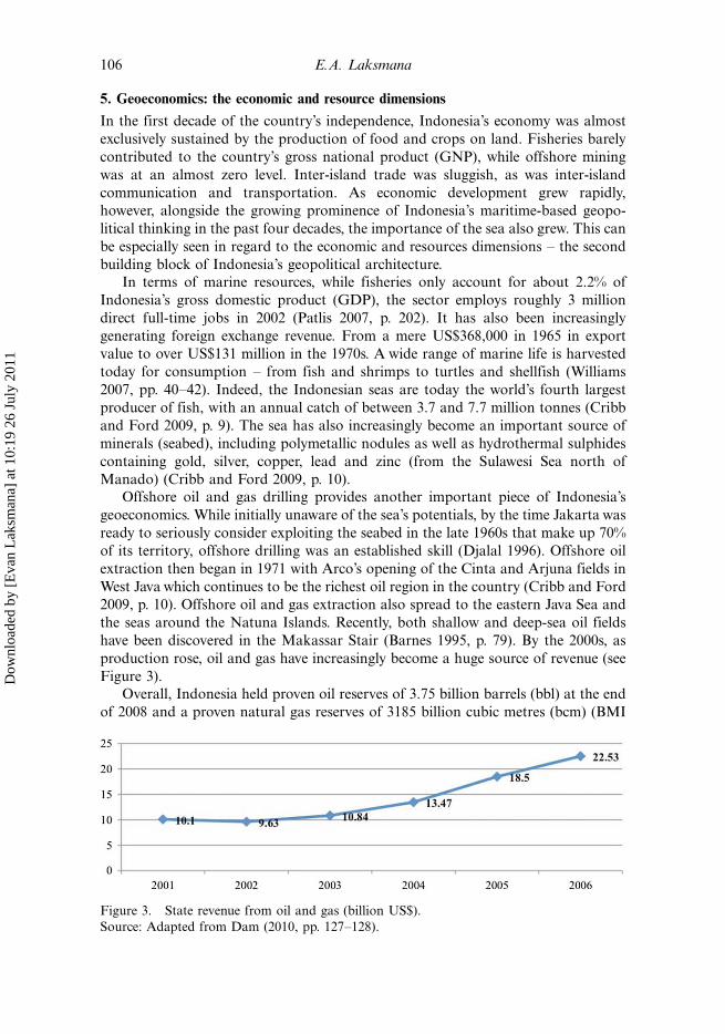
have been discovered in the Makassar Stair (Barnes 1995, p. 79). By the 2000s, as
production rose, oil and gas have increasingly become a huge source of revenue (see
Figure 3).
Overall, Indonesia held proven oil reserves of 3.75 billion barrels (bbl) at the end
of 2008 and a proven natural gas reserves of 3185 billion cubic metres (bcm) (BMI
Figure 3. State revenue from oil and gas (billion US$).
Source: Adapted from Dam (2010, pp. 127�128).
106 E.A. Laksmana
Dow
nloa
ded
by [
Eva
n L
aksm
ana]
at 1
0:19
26
July
201
1

2009, p. 34). It is worth noting that the single largest producer of oil in Indonesia is
not the state-owned Pertamina, but the multinational Chevron, followed by British
Petroleum (BP), ConocoPhillips, ExxonMobil and Total (Sovacool 2010, p. 255).
In the gas fields, Pertamina only controls 21% of natural gas production, but
six international companies dominate the industry: Total, ExxonMobil, Vico,
ConocoPhillips, BP and Chevron (USEIA 2010). This high degree of energy
insecurity suggests yet again another paradox of Indonesia’s geography in the mindsof policymakers: the country may be rich in resources, but it is highly dependent on
foreign companies to exploit them.
That being said, the growing importance of Indonesia’s offshore oil and gas
resources has led the New Order government to organise Indonesia’s maritime
territory into an extensive network of contract areas, or ‘blocks’, over which Jakarta
assigns oil companies to explore and exploit hydrocarbons with certain production-
sharing arrangements (Djalal 1996, p. 81). The basic tenets and architecture of this
geoeconomic foundation of Indonesia’s oil and gas sector still stands today.9 Indeed,
the offshore portion of gas and oil (compared to onshore ones) has grown at an
annual production rate of around 60% in the 1970s and 1980s (Djalal 1996, p. 83).
These blocks have covered virtually all of the waters on the western and central part
of the Archipelago, and recently, the discovery and development of the eastern part is
starting to materialise. This may explain why the Navy’s Western Fleet was the first
to be modernised and developed, while the Eastern Fleet was only recently
developed.Aside from these resources, the sea has also been the primary avenue of transport
and communication, both between the islands within the country as well as between
Indonesia and the outside world. There are more than 750,000 dockings per year at
Indonesian ports loading more than 300 million tonnes of cargo, and about
14 million people travel by its seas annually (Cribb and Ford 2009, p. 8). There are
also around 1700 ports (including 25 main strategic ports), through which about 90%
of Indonesia’s external trade is transported (Ray 2009, pp. 95�96). All in all, the total
value of trade passing through Indonesia’s archipelagic sea lanes amounts to US$300
trillion in the Malacca Strait, US$40 trillion in the Lombok Strait, and US$5 trillion
in the Sunda Strait (Sumaryono 2009, p. 134).
However, in yet another sign of the paradoxical nature of Indonesia’s
geoeconomics, the fact that there are overlapping agencies overseeing marine
management and law enforcement �not to mention an under-developed navy �means that the sea is also a source of security threats and vulnerabilities.10 These
include, inter alia, illegal immigrants, either traversing the waters on their way toAustralia, or ending up staying (Hunter 2006), Indonesians illegally crossing into
neighbouring countries (Hugo 1993), illicit small arms and light weapons and drugs
trafficking (ICG 2010; Muna n.d.), and the more high-profile issue of maritime
piracy (Bateman 2009). Illegal fishing in Indonesian waters, however, has begun to
feature more prominently in recent years. Despite restrictive measures, huge volumes
of fish, shellfish and other marine life are caught illegally, costing the country
roughly between $5 billion and $8 billion annually, according to one local estimate
(Media Indonesia 2010).
Aside from these paradoxes, it is also worth noting that the doctrine of the
Archipelagic Outlook formulated by the New Order explicitly address the issues of
resources by claiming that the archipelagic territory constitutes a single ‘economic
Journal of the Indian Ocean Region 107
Dow
nloa
ded
by [
Eva
n L
aksm
ana]
at 1
0:19
26
July
201
1

entity’, in a sense that ‘the riches of the territory of the archipelago, potentially as
well as effectively, are the collective asset and property of the Nation’ (cited from
Djalal 1996, p. 91). This argument more than anything highlights the economic and
resource dimension of Indonesia’s geopolitical architecture.
6. Geopolitics: the social and political dimensions
The third building block of Indonesia’s geopolitical architecture, the social and
political dimensions, can be thought of comprising two different levels: internal and
external. Internally, it speaks to the country’s history of separatism and internal
unrest as well as its highly diverse socio-ethnic-religious composition. Indonesia has
more than 250 million people divided into over 300 ethnic groups with their ownlanguage, history and socio-cultural systems, as well as five major religions The
problem is not only a matter of sheer diversity. However, a dozen or more of the non-
Javanese ethnic groups are large enough to credibly claim a separate national status
(Cribb and Ford 2009, p. 6), making separatism a believable and even feasible option,
especially given the geographic fragmentation of the country.
Furthermore, the uneven level of economic development between Jakarta and the
regions (and in some cases, exploitation by the former), between the geographically
dispersed major ethnic groups have created convoluted centre�periphery relationsfilled with underlying tensions. The advent of political and financial decentralisation
in 2001 has reduced some of these tensions (Erb et al. 2005). However, the ineffective
governance capacity of many of these newly-formed local administrations continues
to exacerbate problems of corruption, poverty, unemployment and a lack of
economic development in the regions and outer islands. Even the establishment of
direct local elections for district chiefs, mayors and governors through popular
voting has not seemed to make a crucial difference in alleviating the problems
surrounding good local governance (Erb and Sulistiyanto 2009).This has two immediate implications for Indonesia’s national security system and
geopolitical architecture. First, as discussed in the previous section regarding
geostrategy, internal security threats � from separatism to terrorism and subversions
�continue to dominate the country’s strategic environment; and, by implication, the
nature of strategic thinking among policymakers. As such, many of the responses
provided by the state centres on either social-economic solutions of development (as
can been seen in regard to maritime piracy, for instance), or repressive actions taken
by the security forces (as can be seen in Aceh or Papua). Second, the dispersion ofthe different socio-ethnic-religious groups across the archipelago provides a rationale
to spread out the Army’s Territorial Command structure (paralleling and covering
administrative provinces, districts, and villages) as a mechanism to ensure that
internal security threats � actual or potential � can be either nipped in the bud, or
quelled as soon as possible. The advent of decentralisation political and financially
empowering the regions further encourages this line of thinking (Laksmana 2010).
Yet, paradoxically again, the geographical separation among the major ethnic
groups is what perhaps makes the country function as a ‘unitary state’ by placingsome distance and by avoiding socio-cultural collisions on a regular basis. It has even
been argued that Suharto’s New Order promoted and exploited the myth of a
maritime way of life to create a sense of identity among these disparate groups as it
sidesteps the problems they might have on land (Acciaoli 2001). Once again, this
108 E.A. Laksmana
Dow
nloa
ded
by [
Eva
n L
aksm
ana]
at 1
0:19
26
July
201
1

speaks of the dual dimension of the country’s geographical traits with regard to the
social-political dimensions.
Indonesia’s strategic thinking in this matter is further reflected and developed
within the doctrine of National Resilience, which is also a by-product of Suharto’s
Archipelagic Outlook. This doctrine asserts that national security does not depend
on external alliances, but rather on the strengthening of internal ‘resilience’ on allaspects of national life: economic, political, military and socio-cultural. In essence,
national resilience seeks to strengthen the country’s domestic political conditions to
achieve stability and by implication, fend off any future or potential threats facing
the country. National resilience thus complements the Archipelagic Outlook by
envisioning a unified state � politically, economically, social-culturally, militarily and
territorially. A related concept is what is known as ‘regional resilience’ � the sum of
the national resilience of the respective regional countries, enabling them to settle
jointly their common problems and look after their future well-being together �which was promoted and adapted into the Association of Southeast Asian Nations
(ASEAN) norms and practices (Tarling 2006, p. 138).
This relates to the second level of the social and political dimensions: external �or
more specifically, its foreign policy. This speaks about the country’s sense of regional
entitlement as the leader in Southeast Asia as well as the sense of insecurity and
suspicion vis-a-vis extra-regional major powers. This sense of insecurity is best
exemplified by the strong belief among Indonesia’s policymakers that the future ofthe country will increasingly depend on its ability to manoeuvre between the United
States and China (Novotny 2010). The sense of suspicion is partly attributed to the
strong feelings of nationalism and anti-colonialism, developed as a result of the bitter
experiences with foreign powers throughout its history. The fact that each of the
major powers, China, Britain, Japan, Netherlands, Soviet Union and United States,
feature prominently and has at one time or another been engaged in ‘hostile acts’
against the country has left an enduring imprint within the minds of the
policymakers.11
Thus, subsequent governments, from Sukarno’s Old Order to the present
administration of President Susilo Bambang Yudhoyono have never been fully
comfortable with the involvement of extra-regional powers in Southeast Asia. Yet,
some within the foreign policy elite believe that given China’s rise, the presence of the
United States is a tolerable option. This argument is based on the geopolitical
awareness that the United States is ‘further away’ and therefore poses less of a
serious threat than regional powerhouses closer to Indonesia (Novotny 2010, p. 322).
Policymakers also acknowledge that given Indonesia’s strategic position, balancingextra-regional powers may be inevitable. This is why the foreign policy elite has
always preferred to embrace an inclusive foreign policy: ‘establishing and maintain-
ing at least workable relations with as many states as possible’, and striving for ‘the
maintenance of a balance of power among all these states’ to create a safe space for
manoeuvring (Novotny 2010, p. 302).
This helps explain Indonesia’s support and various initiatives through ASEAN to
ensure that the region would be free from external intervention. This includes the
creation of the Zone of Peace, Freedom, and Neutrality (ZOPFAN) in 1971, the
signing of the Treaty of Amity and Cooperation (TAC) in 1976, and the Southeast
Asia Nuclear Weapon Free Zone (SEANWFZ) in 1997. These arrangements may
well ‘reflect a very strong belief in the balance of power within a multilateral
Journal of the Indian Ocean Region 109
Dow
nloa
ded
by [
Eva
n L
aksm
ana]
at 1
0:19
26
July
201
1

arrangement’ (Novotny 2010, p. 303). Today, this balancing act falls under what the
Ministry of Foreign Affairs calls ‘dynamic equilibrium’. One high-ranking official
argued in January 2011 that one of the three key priorities of Indonesia as ASEAN
Chair this year is to ‘ensure that the regional architecture and dynamics remainfavourable to the creation of a dynamic equilibrium where ASEAN can and will play
a central role’ (Oratmangun 2011).
7. Implications: from the Pacific to the Indian Ocean?
Indonesia’s Minister for Marine Affairs and Fisheries recently remarked: ‘The
government believes that the Atlantic Ocean is the past, the Pacific Ocean is today,
and the Indian Ocean is the future’ (cited in Adamrah 2011). Furthermore, theminister added that the government would soon release books on Indian Ocean
economic policies and governance that would describe how the country views the
ocean for food security in the future. Indonesia was also said to be working closely
with India in any cooperative endeavours in the Indian Ocean Region. This
development signals a quiet but significant shift in the country’s geopolitical
orientation and focus.
For more than 60 years, as mentioned in the previous sections, Indonesia’s
foreign policy and security elite has focused on the country’s strategic crossroadslocation. However, what they primarily had in mind were either the highly-prized
Malacca Straits controlling the region’s economic, energy and military lifeline, or the
contentious South China Sea that draws in regional powerhouse China into
Indonesia’s front yard in disputes over potential energy sources and strategic
waterways with the country’s closest neighbours (Suryadinata and Dinuth 2001).
Surprisingly, the Indian Ocean, and relations with India as the biggest power in that
region, has not featured prominently in the country’s strategic thinking.
In the past, Indonesia did pay close attention to the Indian Ocean Region,especially during the 1970s and 1980s. But this was largely related to the strategic
rivalry in the Indian Ocean that had the potential to spill over into Southeast Asia.
President Suharto’s former adviser, Ali Moertopo (1977), p. 214), wrote: ‘The
growing superpower rivalry in the Indian Ocean is deplored by Indonesia . . . [and it]
fears that such a rivalry could not only lead to an armed confrontation, but also
generate undesirable pressures and demands on riparian and hinterland nations’.
However, as soon as the Cold War ended, the Indian Ocean Region seems to have
vanished from the minds of policymakers, especially given Indonesia’s closerpersonal history with India during the 1950s and the generally positive tone of the
overall relations. This is perhaps among the reasons why India’s recent rise is viewed
positively (Novotny 2010, p. 226).
While today’s strategic environment in the Asia-Pacific region is changing, as
suggested by the quote earlier in this section, the preceding analysis on Indonesia’s
geopolitical architecture can help provide a better structured assessment of why the
Indian Ocean is starting to feature more prominently in Indonesia’s strategic
thinking. First of all, in terms of the security and strategic dimension, three factorsare increasingly prominently for Jakarta in relation to the Indian Ocean Region: (1)
Islamic radicalism and terrorism; (2) maritime security; and (3) great power politics.
Studies have shown that the recent development of terrorism and Islamic
radicalism in Indonesia can be traced to groups in Central and South Asia (for
110 E.A. Laksmana
Dow
nloa
ded
by [
Eva
n L
aksm
ana]
at 1
0:19
26
July
201
1

example, Gunaratna 2002; ICG 2003). Some of these groups were rumoured to have
‘slipped into’ the country’s porous borders in the Indian Ocean Region. The same
porous borders on the northern tip of Sumatera are also as among the entry points
for many illegal immigrants traversing Indonesian waters. Meanwhile, as piracyincreases along with the strategic centrality of the Malacca Straits, maritime security
in the Indian Ocean is also increasingly becoming a common strategic ground for
Indonesia and India.
Also, the relative decline of Russia and the United States, and the rise of China
and India amidst the growing complexity of maritime territorial disputes, energy
insecurity and economic development, highlight the possible return of great power
politics. With the United States, China and Japan competing over the control and
stability in Indonesia’s eastern flank (the Pacific Ocean), the role of the Indian Navyas the strongest power in the Indian Ocean is increasingly critical to ensure a
balanced order and stability in Indonesia’s western flank. This is among the key
reasons behind the signing of the Strategic Partnership between India and Indonesia
in 2005.
Second, in terms of the economic and resource dimension, China and India’s rise
as economic powerhouses amidst Japan’s relative decline is further giving weight to
the geoeconomic shift in the region with domestic economic ramifications for
Jakarta. For instance, as India’s economy surges, it is increasingly looking towardsIndonesian coal and palm oil, and is likely to surpass Japan as the biggest buyer of
Indonesian coal. The Indonesian Coal Mining Association stated that India’s coal
imports from Indonesia were likely to rise to 70 million metric tons by 2012, up from
40 million tons in 2010 (Jakarta Globe 2010). In a recent visit to New Delhi in
January 2011, President Susilo Bambang Yudhoyono inked a memorandum of
understanding worth US$15.1 billion and set an ambitious target of doubling trade
over the next five years in the areas of mining, infrastructure development, gas and
petroleum. This highlights the economic and resource dimensions of Indonesia’sresurgent interest in the Indian Ocean Region.
Finally, in terms of the social and political dimension, Indonesia’s interest in the
Indian Ocean Region has more to do with foreign policy issues and the stability of its
western flank than with the influence of India in domestic political affairs. For one
thing, India never had a history of intervening directly in Indonesia’s internal affairs
� unlike China and the United States � nor has it ever caused heightened political
economic tensions � unlike Japan. For another, as India grows to be a regional
powerhouse, Indonesia has a stake in its success in the global stage such as the G-20and UN Security Council. This is because of two basic reasons. First, India and
Indonesia, as the two biggest democracies in the region, are natural allies and both
have plenty to offer to each other. Second, at the very least, if India can be successful
on the world stage, it would provide assurances that perhaps Indonesia can follow.
8. Summary and conclusion
The preceding analysis has highlighted the evolution and origins of Indonesia’sgeopolitical architecture. It has also described and analysed three fundamental
building blocks of that architecture: geostrategy (the military and security dimen-
sions), geoeconomics (the resource and economic dimensions) and geopolitical (the
social and political dimensions). The paper has also detailed how these three building
Journal of the Indian Ocean Region 111
Dow
nloa
ded
by [
Eva
n L
aksm
ana]
at 1
0:19
26
July
201
1

blocks influence Indonesia’s strategic thinking, foreign policy and national security
system. The analysis also highlights the paradoxical nature of Indonesia’s geography
as both a source weakness or vulnerability and a source of potential power. Finally,
the paper has shown why and how the Indian Ocean Region is increasingly becoming
a significant focus of the country’s strategic thinking and foreign policy focus.
While this paper does not claim is that these arguments are novel in themselves,
they do nonetheless represent among the earliest attempts to systematically analyse
and assess the country’s geopolitical thinking and � to place it within the bigger
picture � how it shapes strategic thinking, foreign policy and the national security
system. Certainly, further research is needed to process and trace the development of
Indonesia’s strategic thinking. For example, whether and how the thoughts of
ancient scholars and statesmen originating from the Archipelago still resonates
within the policymakers today, or whether the thoughts of Western thinkers such as
Mahan, MacKinder, Clausewitz and others are more influential. More research
should also be conducted on how the foreign and security elite consider multi-
lateralism as an ‘extension’ of geopolitical strategic thinking.
That said, given the importance that Indonesia will play this year as the Chair of
ASEAN, its role within the G-20, and other regional and global forums, under-
standing the geopolitical focus and thinking of the country remains a worthy
exercise. Furthermore, because geography as a determinant of foreign policy and
national security system is permanent, understanding Indonesia’s geopolitical
architecture could form the initial basis of any assessment � and in some cases,
policy predictions � of the country’s future trajectory in the future. As a final word of
caution, however, while this paper has arguably provided the initial skeleton and
sketch of Indonesia’s geopolitical architecture, how and under what conditions that
structure will be ‘filled’ to take the country forward would depend on the political
will of the existing government.
Notes
1. These leaders were from the Preparatory Committee for the Independence of Indonesia(PPKI). Some of their writings and speeches can be found in Feith and Castle (1970)
2. In preparing for the 17 August 1945 Declaration of Independence, the founding fathersdid not seriously consider the issues surrounding the future country’s territorial border.And between 1949 and 1950, none of the decrees and government regulations issued wasmaritime or sea-related. For details surrounding this period, see Jones (1964), Penders(1979), and Djalal (1996)
3. While the level of Dutch forces could be seen as relatively low, General Nasution, thenhead of the Army, believed that the presence of open seas within Indonesia’s territorycould allow Holland to send in more military assets, and eventually ‘attack our air base inBandung, Naval base in Surabaya, and our capital’ (cited in Pauker 1963, p. 287). TheCabinet also had strong suspicions that the United States has been complicit in orsupporting the country’s regional rebellions (Kahin and Kahin 1997)
4. Throughout this paper, the term ‘Archipelagic Outlook’, ‘Archipelagic Doctrine’,‘Archipelagic State Concept’ and ‘Archipelagic Concept’ refers to the same fundamentaloutlook or thinking that considers Indonesia as a unified geographical (maritime andland), political, security, economic, and social entity. Specific policy expressions of thisconcept will be further noted throughout the paper.
5. Some of the historical details of Indonesia’s journey throughout UNCLOS to fight for theArchipelagic Doctrine can be found in Butcher (2009).
112 E.A. Laksmana
Dow
nloa
ded
by [
Eva
n L
aksm
ana]
at 1
0:19
26
July
201
1

6. The criteria are narrowly defined as ‘navigations with peaceful purposes through theterritorial sea and internal waters: (1) from the high sea to Indonesian ports, and viceversa, (2) from on high sea to another high sea’. It also necessitates military vessels andnon-commercial government ships to give prior notification to the naval chief beforeentering Indonesian waters. See Djalal (1996, p. 52�53)
7. The PKI was decimated and its follower arrested or killed after they were allegedlyorchestrating an attempted coup. For the details surrounding the coup, the destruction ofthe PKI, and the subsequent rise of the Armed Forces to dominate Indonesia’s politicalsystem, see Crouch (1988), and Roosa (2006).
8. The Indonesian Armed Forces or ABRI would later change its name to IndonesianNational Defence Forces or TNI in 1999 following the separation of the National Policefrom the institution.
9. While many of these contracts were awarded in the late 1960s, given the long-term value ofthe arrangements, it was only recently in the past 10 years or so that the government is re-negotiating some of them with major oil companies. This is why some if not most of theseblocks still stand.
10. Marine management and enforcement is currently spread across 12 different governmentagencies under the Ministry of Finance, Ministry of Justice and Human Rights, Ministryof Marine Affairs and Fisheries, Ministry of Forestry, Ministry of Defence, Ministry ofTransportation, Maritime Security Coordinating Board, and the National Police.
11. The Japanese invaded and occupied it during World War II; the Dutch colonised it forover three centuries and continued to briefly control West Guinea; the British assistedHolland’s attempt to re-colonise it after Japan’s defeat; the Soviets were seen to play a rolein the abortive 1948 communist revolt; the Americans were supporting regional rebels inSumatera and Celebes; and the Chinese was seen to be behind the 1965 alleged coup.Details of these bitter encounters between Indonesia and the major powers can be seen inKahin and Kahin (1997), Mortimer (1976), and McMillan (2005)
12. Numerous policy papers and documents produced in the past ten years by the Ministry ofDefence, Military Headquarters, and the National Resilience Institute, which the authorstudied, all cited the thoughts and works of Clausewitz, Mahan, MacKinder, Spykman,and other Western thinkers. The Indonesian Navy even specifically cited two academicworks by the U.S. Naval Postgraduate School as the basis to formulate their doctrine.
References
Acciaoli, G. (2001), ‘Archipelagic culture as an exclusionary government discourse inIndonesia’, Asia Pacific Journal of Anthropology, Vol. 2, no. 1, pp. 1�23.
Adamrah, M. (2011), ‘Indian Ocean needs maritime law as interests intersect’, The JakartaPost, 2 February.
Alfandi, W. (2002), Reformasi Indonesia: Bahasan dari Sudut Pandang Geografi Politik danGeopolitik. Yogyakarta: Gadjah Mada University Press.
Anderson, B.R.O. (1990), Language and Power: Exploring Political Cultures in Indonesia.Ithaca, NY: Cornell University Press.
Anggoro, K. (2006), ‘Geopolitik, Pengendalian Ruang Laga, dan Strategi PertahananIndonesia’, in B. Bandoro, ed., Perspektif Baru Keamanan Nasional. Jakarta: Centre forStrategic and International Studies, pp. 61�79.
Barnes, P. (1995), Indonesia: The Political Economy of Energy. Oxford: Oxford UniversityPress.
Bateman, S. (2009), ‘Piracy and armed robbery against ships in Indonesian waters’, inR. Cribb and M. Ford, eds., Indonesia Beyond the Water’s Edge: Managing an ArchipelagicState. Singapore: Institute of Southeast Asian Studies, pp. 117�133.
Bradford, J.F. (2008), ‘Shifting the tides against piracy in Southeast Asian waters’, AsianSurvey, Vol. 48, no. 3, pp. 473�491.
Business Monitor International (BMI) (2009), Indonesia Oil and Gas Report Q1 2010. London:Business Monitor International.
Butcher, J.G. (2009), ‘Becoming an archipelagic state: The Juanda Declaration of 1957 and thestruggle to gain international recognition of the Archipelagic Principle’, in R. Cribb and
Journal of the Indian Ocean Region 113
Dow
nloa
ded
by [
Eva
n L
aksm
ana]
at 1
0:19
26
July
201
1

M. Ford, eds., Indonesia Beyond the Water’s Edge: Managing an Archipelagic State.Singapore: Institute of Southeast Asian Studies, pp. 28�48.
Cribb, R. and Ford, M. (2009), ‘Indonesia as an archipelago: Managing islands, managing theseas’, in R. Cribb and M. Ford, eds., Indonesia beyond the Water’s Edge: Managing anArchipelagic State. Singapore: Institute of Southeast Asian Studies, pp. 1�27.
Crouch, H. (1988), The Army and Politics in Indonesia. Cornell, NY: Cornell University Press.Dam, S. (2010), Politik Kelautan. Jakarta: Bumi Aksara.Danusaputro, M. (1980), Tata Lautan Nusantara: Dalam Hukum dan Sejarahnya. Bandung:
Binacipta.Dillon, D.R. (2000), ‘Piracy in Asia: A growing barrier to maritime trade’, Heritage
Foundation Backgrounder No. 1379, 22 June.Djalal, D.P. (1996), The Geopolitics of Indonesia’s Maritime Territorial Policy. Jakarta: Centre
for Strategic and International Studies.Dodds, K. (2007), Geopolitics: A Very Short Introduction. Oxford: Oxford University Press.Dupont, A. (1996), ‘Indonesian defence strategy and security: Time for a rethink?
Contemporary Southeast Asia, Vol. 18, no. 3, pp. 275�297.Eklof, S. (2006), Pirates in Paradise: A Modern History of Southeast Asia’s Maritime
Marauders. Copenhagen: NIAS.Erb, M. and Sulistiyanto, P. eds., (2009), Deepening Democracy in Indonesia? Direct Local
Elections for Local Leaders. Singapore: Institute of Southeast Asian Studies.Erb, M., Sulistiyanto, P. and Faucher, C. eds., (2005), Regionalism in Post-Suharto Indonesia.
London: RoutledgeCurzon.Feith, H. and Castles, L. eds., (1970), Indonesian Political Thinking, 1945�1965. Ithaca, NY:
Cornell University Press.Gunaratna, R. (2002), Inside Al-Qaeda: A Global Network of Terror. New York: Berkley
Books.Hardjosoedarmo, S. (1981), ‘Dasar-dasar Pemikiran untuk Pengembangan TNI-AL dalam
Rangka Implementasi Wawasan Nusantara dan CADEK’, in Wantanas, ed. WawasanNusantara, Ketahanan Nasional, dan Keamanan Nasional. Jakarta: National DefenseCouncil, pp. 174�180.
Hatta, M. (1953), ‘Indonesia’s foreign policy’, Foreign Affairs, Vol. 31, no. 3, pp. 441�452.Ho, J.H. (2006), ‘The security of sea lanes in Southeast Asia’, Asian Survey, Vol. 46, no. 4,
pp. 558�574.Hugo, G. (1993), ‘Indonesian Labour Migration to Malaysia: Trends and Policy Implications,’
Asian Journal of Social Science, Vol. 21, no. 1, pp. 36�70.Hunter, C. 2006. ‘People in Between’, Inside Indonesia, No. 88 (October�December).
Available at http://www.insideindonesia.org/edition-49/49-special-issue-on-sumatra.Indonesian Navy (2010), Naskah Awal Seminar TNI Angkatan Laut: Implementasi UNCLOS
dalam Rangka Menegakkan Kedaulatan, Menjaga Keutuhan Wilayah dan MelindungiKeselamatan Bangsa. Jakarta: Mabes TNI AL.
International Crisis Group (ICG), (2003), ‘Jemaah Islamiyah in Southeast Asia: Damaged butstill dangerous’, Asia Report No. 63, 26 August. Jakarta/Brussels: International CrisisGroup.
International Crisis Group (ICG), (2010), ‘Illicit arms in Indonesia’, Asia Briefing No. 109,6 September. Jakarta/Brussels: International Crisis Group.
Jakarta Globe, (2010), ‘India poised to take top spot for Indonesian coal exports’, 21September.
Jones, G. (1964), ‘Soekarno’s early views upon the territorial boundaries of Indonesia’,Australian Outlook, Vol. 18, no. 1, pp. 30�39.
Kahin, G.M. and Kahin, A. (1997), Subversion as Foreign Policy: The Secret Eisenhower andDulles Debacle Indonesia. Seattle, WA: University of Washington Press.
Kroef, J.V.D. (1976), ‘National security, defense strategy, and foreign policy perception inIndonesia’, Orbis, Vol. 20, no. 2, pp. 461�495.
Kusumaatmadja, M. (1982), ‘Wawasan Nusantara’, in POLKAM: Pembangunan BidangPolitik dan Keamanan. Jakarta: Percetakan Negara RI.
Laksmana, E.A. (2010), ‘Dinamika Politik Militer Indonesia: Kontinuitas di TengahPerubahan’, in B. Sukadis, ed., Media dan Reformasi Sektor Keamanan. Jakarta: Geneva
114 E.A. Laksmana
Dow
nloa
ded
by [
Eva
n L
aksm
ana]
at 1
0:19
26
July
201
1

Centre for the Democratic Control of the Armed Forces and Indonesian Institute ofDefence and Strategic Studies, pp. 91�111.
Lowry, R. (1996), The Armed Forces of Indonesia. St. Leonards, NSW: Allen & Unwin.McMillan, R. (2005), The British Occupation of Indonesia 1945�1946: Britain, the Netherlands
and the Indonesian Revolution. London: Routledge.Media Indonesia (2010), ‘Akibat illegal fishing, Negara Rugi 80 triliun per tahun’, Media
Indonesia, 22 August.Ministry of Foreign Affairs (MOFA) (1986), Perjuangan Indonesia di Bidang Hukum Laut.
Jakarta: Research and Development Agency, Ministry of Foreign Affairs.Ministry of Defence (MOD) (2008), Doktrin Pertahanan Negara. Jakarta: Directorate General
for Defence Strategy, Ministry of Defence.Ministry of Defence (MOD) (2010), Minimum Essential Force Komponen Utama. Jakarta:
Directorate General for Defence Strategy, Ministry of Defence.Moerdani, L.B. (1993), Upholding the Unity and Unitary of the Nation: Vision and Views of
General of the Army (Ret.) L.B. Moerdani. Jakarta: Yayasan Kejuangan Panglima BesarSudirman.
Moertopo, A. (1977), ‘Indonesia and the Indian Ocean’’, Institute for Defense Studies andAnalyses, Vol. 9, no. 3, pp. 214�215.
Mortimer, R. (1976), Indonesian Communism under Sukarno: Ideology and Politics 1959�1965.Ithaca, NY: Cornell University Press.
Muir, R. and Paddison, R. (1981), Politics, Geography, and Behaviour. London: MethuenPublishers.
Muna, R. (n.d.), Small Arms and Light Weapons and Drug Trafficking in Indonesia. Availablefrom http://www.rsis-ntsasia.org/resources/publications/research-papers/transnational-crime/Riefqi.pdf.
Novotny, D. (2010), Torn between America and China: Elite Perceptions and Indonesian ForeignPolicy. Singapore: Institute of Southeast Asian Studies.
Oegroseno, A.H. (2009), ‘Indonesia’s maritime boundaries’, in R. Cribb and M. Ford, eds.,Indonesia Beyond the Water’s Edge: Managing an Archipelagic State. Singapore: Institute ofSoutheast Asian Studies, pp. 49�58.
Oratmangun, D. (2011), ‘Kepemimpinan Indonesia untuk ASEAN tahun 2011: Prioritas danTarget’, paper presented at the seminar on ‘Indonesia and ASEAN in 2011’, organised bythe Centre for Strategic and International Studies, Jakarta, 13 January.
Panggabean, M. (1982), ‘Implikasi Wawasan Nusantara pada Bidang Politik dan KeamananNasional Indonesia’, in Lemhanas, ed. Bunga Rampai Wawasan Nusantara II. Jakarta: TheNational Defence College, pp. 28�36.
Patlis, J. (2007), ‘Indonesia’s New Fisheries Law: Will it Encourage Sustainable Managementor Exacerbate Over-Exploitation,’ Bulletin of Indonesian Economic Studies, Vol. 43, no. 2,pp. 201�226.
Pauker, G. (1963), The Indonesian Doctrine of Territorial Warfare and Territorial Management.Santa Monica, CA: RAND Corporation.
Penders, C.L.M. (1979), Milestones of My Journey: The Memoirs of Ali Sastroamidjojo:Indonesian Patriot and Political Leader. Brisbane, QLD: University of Queensland Press.
Rabasa, A. and Haseman, J. (2002), The Military and Democracy in Indonesia: Challenges,Politics and Power. Santa Monica, CA: RAND Corporation.
Ray, D. (2009), ‘Indonesian Port Sector Reform and the 2008 Shipping Law,’ in R. Cribb andM. Ford, eds., Indonesia Beyond the Water’s Edge: Managing an Archipelagic State.Singapore: Institute of Southeast Asian Studies, pp. 94�116.
Roosa, J. (2006), Pretext for Mass Murder: The September 30th Movement and Suharto’s CoupD’etat in Indonesia. Madison, WI: University of Wisconsin Press.
Soebroto, S., Sunardi, and Wahyono. (1983), Konvensi PBB tentang Hukum Laut: SebuahTinjauan. Jakarta: Surya Indah.
Sebastian, L.C. (2006), Realpolitik Ideology: Indonesia’s Use of Military Force. Singapore:Institute of Southeast Asian Studies.
Sebastian, L.C. and Lanti, I. (2010), ‘Perceiving Indonesian approaches to internationalrelations theory’, in A. Acharya and B. Buzan, eds. Non-Western International RelationsTheory: Perspectives on and Beyond Asia. London: Routledge, pp. 148�173.
Journal of the Indian Ocean Region 115
Dow
nloa
ded
by [
Eva
n L
aksm
ana]
at 1
0:19
26
July
201
1

Sempa, F.P. (2002), Geopolitics: From the Cold War to the 21st Century. New Brunswick, NJ:Transaction Publishers.
Siahaan, N.H.T. and Suhendi, H. (1989), Hukum Laut Nasional: Himpunan PeraturanPerundang-undangan Kemaritiman. Jakarta: Djambatan.
Sovacool, B.K. (2010), ‘The political economy of oil and gas in Southeast Asia: Headingtowards the natural resource curse? The Pacific Review, Vol. 23, no. 2, pp. 225�259.
Spykman, N.J. (1969), The Geography of the Peace. Hamden, CT: Archon Books.Sumaryono, D. (2009), ‘The Indonesian maritime security coordinating board’, in R. Cribb
and M. Ford, eds., Indonesia Beyond the Water’s Edge: Managing an Archipelagic State.Singapore: Institute of Southeast Asian Studies, pp. 134�145.
Suryadinata, E. and Dinuth, A. eds., (2001), Geopolitik dan Konsepsi Ketahanan Nasional:Pemikiran Awal, Pengembangan, dan Prospek. Jakarta: Paradigma Cipta Yatsiagama.
Suryohadiprodjo, S. (1969), ‘The defense of Indonesia’, in K.K. Sinha, ed. Problems ofDefence in South and Southeast Asia, Bombay: Manaktalas, pp. 228�235.
Tarling, N. (2006), Regionalism in Southeast Asia: To Foster the Political Will. London:Routledge.
USEIA (2010), ‘Indonesia country analysis brief ’, U.S. Energy Information Administration.Available at http://www.eia.gov/countries/cab.cfm?fips=ID, accessed 11 June 2011.
Weinstein, F. (1976), Indonesian Foreign Policy and the Dilemma of Dependence: From Sukarnoto Suharto. Ithaca, NY: Cornell University Press.
Widjajanto, A. (2010), ‘Evolusi Doktrin Pertahanan Indonesia, 1945�1998’, Jurnal Prisma,Vol. 29, no. 1, pp. 3�20.
Widjajanto, A. and Wardhani, A. (2008), Hubungan Intelijen � Negara 1945�2004. Jakarta:Friedrich Ebert Stiftung and Centre for Global Civil Society Studies, University ofIndonesia.
Williams, M.J. (2007), Enmeshed: Australia and Southeast Asia’s Fisheries. Sydney: LowyInstitute for International Policy.
Yamin, M. (1970), ‘Unity of our country and our people’, in H. Feith and L. Castles, eds.,Indonesian Political Thinking, 1945�1965. Ithaca, NY: Cornell University Press, pp. 439�441.
116 E.A. Laksmana
Dow
nloa
ded
by [
Eva
n L
aksm
ana]
at 1
0:19
26
July
201
1


![Imperialism in the 21st Century · 2020. 9. 4. · Imperialism in the 21st Century By Doug Lorimer “The three grand imperatives of imperial geostrategy [are] to prevent collusion](https://img.pdfslide.net/doc/110x75/5ff530a5482d1409ea3443bc/imperialism-in-the-21st-century-2020-9-4-imperialism-in-the-21st-century-by.jpg)