Embed Size (px)
Citation preview

The Farm Water Quality PlanPlan components compiled by MARY BIANCHI, UC Cooperative Extension Farm Advisor,San Luis Obispo County; DANIEL MOUNTJOY, Area Resource Conservationist, USDA–NRCS;and ALISON JONES, Watershed Management Initiative Coordinator, Central Coast RegionalQuality Control Board.
Use these sections to formalize a Farm Water Quality Plan for your farm.
This is the Farm Water Quality Plan for _____________________________________________
Prepared by: ____________________________________________________________________
Date: _________________
CONTENTS
Section page
Property Information ...................................................................................2
Operations and Land Use ............................................................................3
Statement of Goals........................................................................................5
Basin Water Quality Information .................................................................7
Farm/Ranch Map ........................................................................................14
Site Assessment and Practices Planning.....................................................16
Managing Sediment..................................................................17
Managing Irrigation .................................................................27
Managing Pesticides.................................................................32
Managing Nutrients .................................................................37
Managing Salinity ....................................................................41
Practices to Improve Water Quality in Waterways..........................43
Self-Evaluation............................................................................................48
PUBLICATION 8332
UNIVERSITY OF CALIFORNIA
Division of Agriculture and Natural Resources
http://anrcatalog.ucdavis.edu
In partnership with
http://www.nrcs.usda.gov
Farm Water Quality Planning
A Water Quality and Technical Assistance Program
for California Agriculturehttp://waterquality.ucanr.org
This PLAN is part of the FarmWater Quality Planning
(FWQP) series, developed for ashort course that provides train-
ing for growers of irrigatedcrops who are interested in
implementing water quality pro-tection practices. The short
course teaches the basic con-cepts of watersheds, nonpoint
source pollution (NPS), site-assessment techniques, and
evaluation techniques.Management goals and prac-
tices are presented for a varietyof cropping systems.

2ANR Publication 8332
PROPERTY INFORMATION
Farm/RanchFarm/Ranch Name:
Mailing Address or P.O. Box:
City, State and Zip Code:
Phone: Size (acres):
OwnerName(s):
Mailing Address or P.O. Box: ■■Same as Farm/Ranch Address
City, State and Zip Code:
Phone: E-mail:
Lessee/ManagerName(s):
Mailing Address or P.O. Box: ■■Same as Farm/Ranch Address
City, State and Zip Code:
Phone: E-mail:
LocationCounty:
Legal Description (Township, Range, Sections):

ANR Publication 8332 3
OPERATIONS AND LAND USE Current farm/ranch enterprises or activities
and the acreage devoted to each
Land use activity Area in acres/sq.ft.
farming (field production) farming (greenhouse/nursery production) grazing livestock dairy feedlot processing (winery, cold storage, etc.) public facilities (winery tasting rooms, etc.) forestry (timber) wildlife preserve camping hunt club Water sources for farming enterprises:
Surface water Groundwater Municipal Reclaimed/Recycled

ANR Publication 8332 4
Operations and Land use, cont'd.
Farming Enterprises Current farm/ranch enterprises or activities
and the acreage devoted to each
Alfalfa/other hay Cotton Strawberries
Caneberries Field crops Tree/fruit/nut crops
Corn (grain) Irrigated pasture Vegetable crops
Corn (silage) Oil crops Vineyard
Other silage Rice Wheat, barley, oats
Greenhouse Container Ground
Shade & temporary Container Ground
Outdoor flowers Container Ground
Schedule for rotated crops:
Livestock Enterprises Number of pastures for grazing _________
Types of livestock Livestock access to water
cow/calf–spring calving troughs and tanks cow/calf–fall calving springs cow/calf–year-round calving streams or creeks stocker production stock ponds goat production water gaps llama production wells horses river ratite (ostrich, emu, etc.) production

5ANR Publication 8332
STATEMENT OF GOALS
Production Goals
■■to pass the farm/ranch on to the next generation
■■to reduce family/farm debt so that only minor borrowing for operating capital is necessary in a typical year
■■to expand existing enterprises
■■to increase income by developing new enterprises
■■to increase profitability
■■to purchase or lease more property
■■to reduce short-term production costs
■■to achieve long-term reduced production costs
■■to increase the value of the land
■■
■■
■■
Quality of Life Goals
■■to reduce energy consumption in our home and in the farm/ranch operation
■■to reduce family debt
■■to provide support for our children’s college education
■■to provide financial or other support to community organizations
■■to reduce household operating expenses
■■to build an emergency fund
■■to be involved in at least one significant community activity that is important to our family’s goals, health, values, or well-being
■■to build a retirement fund
■■to grow crops or raise livestock during my retirement
■■to enhance relationships with neighbors and the community
■■to enhance health and well-being on the farm
■■
■■

6ANR Publication 8332
Statement of Goals, cont’d.
Natural Resource/Water Quality Goals
■■to protect cropland, nursery area, rangeland, pastureland, and/or forestland from erosion
■■to manage farm or ranch roads to reduce movement of sediment into streams, and other water bodies
■■to reduce human-caused erosion of stream banks
■■to increase canopy and/or ground cover in riparian areas or along streams and other water bodies
■■to protect and enhance fish populations and other aquatic resources.
■■to reduce concentration of livestock in or near riparian areas, streams or other water bodies
■■to reduce the opportunity for nutrients, pesticides, and pathogens to enter streams or other water bodies.
■■to maintain and enhance riparian plant communities
■■to reduce wildfire hazard
■■to maintain and protect oak woodland and other upland native plant communities
■■to maintain or improve wildlife habitat
■■to reduce/manage invasive weeds
■■
■■
■■

ANR Publication 8332 7
REGIONAL AND LOCAL WATER QUALITY INFORMATION
This section is a place for you to document information about your watershed, groundwater basin, and downstream waterbodies that has been collected by a variety of agencies. This information is documented in the following resources: California Coastal Commission (CCC) CCAs http://www.coastal.ca.gov/nps/cca-nps.html California Department of Pesticide Regulation (DPR) GWPA Maps http://www.cdpr.ca.gov/docs/gwp/gwpamaps.htm GWPA Lists by Legal Description http://www.cdpr.ca.gov/docs/gwp/gwpa_lists.htm National Oceanic and Atmospheric Administration (NOAA) – National Marine Fisheries Service (NMFS) Protected Resources Division ESUs http://swr.ucsd.edu/psd/ps1inf.htm#Salmon State Water Resources Control Board (SWRCB) – Regional Water Quality Control Board (RWQCB) Beneficial Uses - Basin Plan http://www.swrcb.ca.gov/rwqcb3/BasinPlan/BP_text/chapter_2/ figs_n_tables/table_2-1.doc Beneficial Use Support - California Water Quality Assessment Report 1998 - Staff Report Part A http://www.swrcb.ca.gov/general/publications/index.html#Cc Clean Water Act Section 303(d) List http://www.swrcb.ca.gov/tmdl/docs/2002reg3303dlist.pdf CCAMP Monitoring Data http://www.ccamp.org/ca/3/3.htm How to complete this section Draw from the above resources to complete this section. If you don’t have access to one of these resources, contact your Watershed Coordinator or contact the agency directly.

ANR Publication 8332 8
Regional and Local Water Quality Information, cont’d.
Location of the Operation — “Watershed Address”
Water Quality Control Board Region
■ Region 1: North Coast
■ Region 2: San Francisco Bay
■ Region 3: Central Coast■ Region 4: Los Angeles
■ Region 5: Central Valley
■ Region 6: Lahontan
■ Region 7: Colorado River Basin
■ Region 8: Santa Ana
■ Region 9: San Diego
Name of the Hydrologic Unit (HU):
Name of the Hydrologic Area (HA):
Downstream Waterbodies
Type(s) of streams on and adjacent to the farm/ranch:
■ Perennial – flow all year
■ Intermittent – flow during and for a period following rainfall
■ Ephemeral – only flow in direct response to rainfall
■ None
List names of all downstream waterbodies, beginning at the property and ending at the ocean:
Pollutants identified in downstream waterbodies:
■ Sediment/Silt Waterbody: _____________________________ Source: ■ 303(d)*■ Cooperative Monitoring ■ Other ___________________
■ Nutrients/Nitrate Waterbody: _____________________________ Source: ■ 303(d)*■ Cooperative Monitoring ■ Other ___________________
■ Pesticides Waterbody: _____________________________ Source: ■ 303(d)*■ Cooperative Monitoring ■ Other ___________________
■ Other(s) Waterbody: _____________________________ Source: ■ 303(d)*■ Cooperative Monitoring ■ Other ___________________
*Waterbodies on Federal 303(d) list are subject to Total Maximum Daily Loads.
Is the watershed you are in designated by the Department of Fish and Game as being within aknown range of an Evolutionary Significant Unit (ESU) for Coho or Steelhead?
Coho ESU? ■ Yes ■ No
If yes, are the Coho Threatened or Endangered? ■ T ■ E
Steelhead ESU? ■ Yes ■ No
If yes, are the Steelhead Threatened or Endangered? ■ T ■ E

ANR Publication 8332 9
9
Regional and Local Water Quality Information, cont’d.
Is a coastal zone downstream of the operation designated by the California Coastal Commissionas a proposed Critical Coastal Area (CCA)? ■ Yes ■ No
Groundwater Basin
Name and Number of the Groundwater Basin:
Is the farm/ranch within an area designated by the California Department of Pesticide Regulationas a Ground Water Protection Area (GWPA)? ■ Yes ■ No
Include maps that indicate your watershed, groundwater basin, and flow of water from youroperation to the ocean.
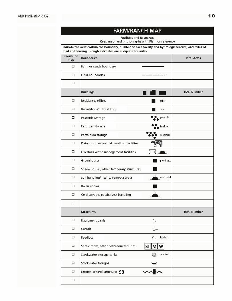

1 1ANR Publication 8332
Farm/Ranch Map, cont’d.
Fences and Roads Total Miles
■■ Fences
■■ Dirt road
■■ Gravel road (label)
■■ Paved road
■■
Hydrologic Features Total Number
■■ Irrigation ditches
■■ Irrigation ditches, lined (label)
■■ Streams and creeks
■■ Springs
■■ Irrigation reservoirs
■■ Recycling reservoirs (label)
■■ Irrigation settling ponds (label)
■■ Stockwater ponds
■■ Tailwater recovery systems (label)
■■ Bridges
■■ Stream crossings
■■ Domestic wells (label)
■■ Irrigation wells
■■ Stockwater wells (label)
■■
FORD
gravel
recycling
settlingpond
lined
well
domesticwell
tailwaterrecoverysystem

1 2ANR Publication 8332
You have completed the basin water quality information that lists important water bodies in yourarea and the water quality problems that have been identified for these water bodies. You havealso created a map of your farm or ranch that lists land uses, facilities, and resources.
The following section can help identify areas of your farm or ranch where you’ve already imple-mented management practices to protect water quality. It can also help determine what areas ofyour farm or ranch can receive the most benefit from the implementation of new managementpractices. These items can be added to your map.
A trip around the property in a vehicle or on foot may be necessary to complete this assessment.Some of the assessment may involve accessing your pesticide use reports, or operations budgetfor nutrients applied to specific fields. Keep this section and the following self-evaluation sectionas a working document to record your decisions and your progress. You should keep records ortake photographs before and after implementation to document changes that occur as a result ofpractices or groups of practices.
If you conclude that you need to make some changes, it may take you a while to decide how toproceed. You may want to compare practices that can accomplish the same thing. Not all prac-tices listed may be applicable or available for your situation. Discuss these options with otherfarmers, consultants, or technical advisors from UCCE, NRCS, RCDs or other organizations. Youshould estimate costs of implementation. You may want to seek cost share funding with NRCSor other sources.
How to complete this section:If you answer “yes” to any of the questions, look at the following table(s) for ManagementPractices. Select Practices that you are currently using or that you think might be useful. Updateannually and keep notes that help with record keeping. If you would like to be more specific, youcan record block designations, square footage, or acres of each selected Practice in the “loca-tion(s)” column. NRCS Conservation Practice Standards that you might want to use are listedwhere applicable. (e.g., Sediment Basin #350).
SITE ASSESSMENT AND PRACTICES PLANNING

ANR Publication 8332
13
Site Assessment and Practices Planning–Sediment, cont'd.
Managing Sediment
Upstream/Upslope Land Use
S1. Is your property affected by sediment from upstream/upslope land uses? Yes No Notes:
Practices to Manage Sediment from Upstream/Upslope Year(s) used
Used or could be helpful
Location(s)
2004
2005
2006
2007
2008
2009
2010
A structure to collect the sediment is installed and maintained
Sediment Basin #350
Water and Sediment Control Basin #638
A structure to divert the sediment is installed and maintained
Diversion #362
Grassed Waterway #412
Lined Waterway #468
Open Channel #582
Structure for Water Control #587
Surface Drainage Ditch #607 & #608
Underground Outlet #620
Vegetation is established to filter the sediment
Conservation Cover #327
Filter Strip #393
Tree/Shrub Establishment #612
Soil erosion and sediment deposition are primary contributors to lowered surface water quality from farmlands. In areas where there are steep slopes, erodible soils, and intense storm characteristics, sediment delivery from farmlands can be relatively high. Roads and other areas of disturbed ground where bare soils are susceptible to the erosive action of water and wind can also be major contributors of sediment to waterbodies.

ANR Publication 8332
14
Site Assessment and Practices Planning–Sediment, cont'd.
Fields and Other Growing Areas S2. Do you notice soil erosion from fields and other growing areas with steep slopes or long lengths of run? Yes No Notes:
Develop a Field Layout to Minimize Erosion Potential Year(s) used
Used or could be helpful
Location(s)
2004
2005
2006
2007
2008
2009
2010
Rows are placed on slopes and grades that minimize erosion
Contour Farming #330
Contour Orchard and Other Fruit Area #331
Row Arrangement #557
Long runs are broken up
Access Road #560
Contour Buffer Strip #332
Diversion # 362
Irregularities that cause concentrated runoff on slopes are removed
Land Smoothing #466

ANR Publication 8332
15
Site Assessment and Practices Planning–Sediment, cont'd.
S3. During rain events, do you notice soil erosion from fields with bare soil or sparse ground cover? Yes No Notes:
Cover Bare Fields to Reduce Rainfall Runoff Potential Year(s) used
Used or could be helpful
Location(s)
2004
2005
2006
2007
2008
2009
2010
Bare soil is covered with vegetation
Conservation Crop Rotation #328
Cover Crop #340
Alternate rows are cultivated and cover cropped
Cover Crop #340
Plant residues or other materials are applied to or managed on the soil surface
Mulching #484
Residue Management #329
Strips of vegetation are placed along rows that are farmed on the contour
Contour Buffer Strip #332
Critical Area Planting #342

ANR Publication 8332
16
Site Assessment and Practices Planning–Sediment, cont'd.
S4. During irrigation, do you notice sediments in runoff from fields? Yes No Notes:
Manage Irrigation Water to Minimize Erosion Potential Year(s) used
Used or could be helpful
Location(s)
2004
2005
2006
2007
2008
2009
2010
Amendments are used to improve infiltration - PAM, gypsum, organic amendments
Anionic Polyacrylamide (PAM) #450
Deep tillage is performed to fracture restrictive soil layers and increase deep percolation where leaching of pollutants to groundwater is not a significant risk
Deep Tillage #324
Soil or substrate moisture status is monitored using tensiometers or other sensors
The application rate of the irrigation system (in/hr) is known
Irrigation system is redesigned or converted to another type
Fields are graded for uniform application of irrigation water
Irrigation Land Leveling #464
Irrigation Water Management #449

ANR Publication 8332
17
Site Assessment and Practices Planning–Sediment, cont'd.
S5. During high winds, do you notice dust blowing from fields with bare soil or sparse ground cover or from field roads? Yes No Notes:
Reduce Wind Erosion Potential Year(s) used
Used or could be helpful
Location(s)
2004
2005
2006
2007
2008
2009
2010
Vegetation is established along the field edges to shield the field from wind
Hedgerow #422
Herbaceous Wind Barrier #603
Windbreak/Shelterbelt Establishment #380 & 650
The bare soil is covered with vegetation
Cover Crop #340
Conservation Crop Rotation #328
Residue Management #329
The soil surface is roughened
Cross Wind Ridges #589A
Surface Roughening #609
Road surfaces are protected with mulch, gravel, water or an environmentally safe dust suppressant
Access Road #560
Mulching #484

ANR Publication 8332
18
Site Assessment and Practices Planning–Sediment, cont'd.
Container Grown Plants, Including Hydroponics S6. Do you grow plants in containers in a system that doesn’t recover all applied water? Yes No Notes:
Reduce Erosion and Runoff in Container Grown Plants Year(s) used
Used or could be helpful
Location(s)
2004
2005
2006
2007
2008
2009
2010
Plants are grouped to increase water and nutrient use efficiency by container size, container design, age, canopy architecture, water and nutrient requirements and/or salt tolerance
Plants are consolidated and irrigation is shut off in unused portions
Containers are filled and packed uniformly
Growing media and/or substrate is selected for high water holding capacity and adequate drainage and aeration
Growing media and/or substrate is stored and mixed in a location sheltered from wind and away from drainage channels
Mulch is used to protect ground surface below containers from erosion.

ANR Publication 8332
19
Site Assessment and Practices Planning–Sediment, cont'd.
Roads and Roadside Ditches
S7. Do you notice rills, gullies or headcuts running down the road? Yes No Notes: S8. Do you notice water-loving vegetation present on the roadbed? Yes No Notes: S9. Is an outboard berm channeling water down the road? Yes No Notes: S10. Do you notice tension cracks on the road surface or outboard fill? Yes No Notes:
Protect Road Surface from Concentrated Runoff Year(s) used
Used or could be helpful
Location(s)
2004
2005
2006
2007
2008
2009
2010
Road placement, grade, and surface conditions are assessed for proper drainage
Roads are graded to reduce erosion
Access Road #560
Roadbeds and/or banks are covered in the winter or during minimal use
Cover Crop #340
Critical Area Planting #342
Erodible soil on the roadbed is permanently protected with road oil, gravel, mulch, or paving
Access Road #560
Mulching #484
Outboard berms are removed
Access Road #560

ANR Publication 8332
20
Site Assessment and Practices Planning–Sediment, cont'd.
S11. Is the road or ditch runoff causing erosion on land below the roadway? Yes No Notes: S12. Are ditch banks or channels being eroded by water flow from greenhouses and other structures, fields or roads? Yes No Notes: S13. Do you notice that the inboard ditch channel is being downcut? Yes No Notes: S14. Is the inboard ditch channel obstructed, causing water to flow onto the road? Yes No Notes: S15. Is overflow from a plugged culvert dierting water down the road surface? Yes No Notes: S16. Do you see rockfall or slumping due to instability of the cutbank or hillslope above the roadway? Yes No Notes:
Protect Ditches and Banks from Concentrated Flow of Runoff Year(s) used
Used or could be helpful
Location(s)
2004
2005
2006
2007
2008
2009
2010
Road placement, grade, and surface conditions are assessed for proper drainage
Vegetation is established in eroding roadside ditches
Grassed Waterway #412
Eroding channels are protected with geotextiles or rock.
Lined Channel #468
Ditches and culverts provide adequate drainage
Grade Stabilization Structure #410
Open Channel #582
Structure for Water Control #587

ANR Publication 8332
21
Site Assessment and Practices Planning–Sediment, cont'd.
Year(s) used
Used or could be helpful
Location(s)
2004
2005
2006
2007
2008
2009
2010
Ditches and culverts are kept clean of debris
Water is diverted away from unstable slopes
Diversion #362
Unstable slopes are treated
Cut Bank Stabilization #742

ANR Publication 8332
22
Site Assessment and Practices Planning–Sediment, cont'd.
Non-Cropped & Non-Road Areas S14. Do you notice erosion or sediment loss from areas of bare soil in areas such as cut banks, field margins, between field blocks or greenhouses, on abandoned slopes, soil mixing/handling or compost areas, equipment yards, parking areas, and postharvest or cold storage facilities? Yes No Notes: S15. Do you see signs of or the potential for sheet erosion, rill erosion, gullies, headcuts, mudslides, or landslides in steep non-cropped areas? Yes No Notes:
Reduce Erosion from Non-cropped Areas Year(s) used
Used or could be helpful
Location(s)
2004
2005
2006
2007
2008
2009
2010
Protect Soil Bare soil is covered with vegetation or mulch
Conservation Cover #327 Critical Area Planting #342
Filter Strip #393 Hedgerow Planting #422
Mulching #484 Range Planting #550
Tree/Shrub Establishment #612 Vegetation is allowed to reestablish by excluding animals, people or vehicles
Use Exclusion #472
Regrade Potential Problem Areas Potential landslide areas are stabilized by reducing and/or supporting the slope
Cut Bank Stabilization #742 Landslide Treatment #453
Gullies are stabilized or reshaped Critical Area Planting #342
Grade Stabilization Structure #410 Structure for Water Control #587

ANR Publication 8332
23
Site Assessment and Practices Planning–Sediment, cont'd.
Year(s) used
Used or could be helpful
Location(s)
2004
2005
2006
2007
2008
2009
2010
Divert Water to a Stable Outlet Channels or conduits to divert water to a stable outlet are installed or improved
Diversion #362 Grassed Waterway #412
Lined Waterway #468 Open Channel #582
Subsurface Drain #606 Structure for Water Control #587
Surface Drainage Ditch #607 & #608 Underground Outlet #620
Facilities roof runoff is collected and diverted to a stable outlet
Roof Runoff Management #558

ANR Publication 8332
24
Site Assessment and Practices Planning–Sediment, cont'd.
Sediment Leaving the Operation
S16. Do you notice sediment moving off the farm after irrigation and/or storm events? Yes No Notes: S17. Do you notice sediment accumulating in ditches, channels, ponds, or other waterways downstream of the farm? Yes No Notes:
Detain or Filter Eroded Sediment Leaving the Operation Year(s) used
Used or could be helpful
Location(s)
2004
2005
2006
2007
2008
2009
2010
Structures to divert sediment to settling areas are installed and maintained
Diversion #362
Lined Waterway #468
Open Channel #582
Structure for Water Control #587
Surface Drainage Ditch #607 & #608
Underground Outlet #620
Structures to collect sediment are appropriately sized, installed and maintained
Irrigation System, Tailwater Recovery #447
Sediment Basin #350
Water and Sediment Control Basin #638
Vegetation is established to filter sediment
Conservation Cover #327
Filter Strip #393
Grassed Waterway #412

ANR Publication 8332
25
Site Assessment and Practices Planning–Sediment, cont'd.
Managing Irrigation
I1. Does tailwater or runoff water leave the operation during irrigation events? Yes No Notes: I2. Could you irrigate more efficiently to reduce the amount of water that leaches out of the root zone to eventually reach the groundwater? Yes No Notes:
Manage Irrigation Water for Maximum Efficiency Year(s) used
Used or could be helpful
Location(s)
2004
2005
2006
2007
2008
2009
2010
Maximize Irrigation System Efficiency
Irrigation efficiency is evaluated by an irrigation mobile lab, UCCE, or a consultant
Irrigation Water Management #449
Regular system maintenance is performed
Irrigators are trained in practices that promote efficient irrigation
Amendments are used to improve infiltration - PAM, gypsum, organic amendments
Anionic Polyacrylamide (PAM) #450
Deep tillage is performed to fracture restrictive soil layers and increase deep percolation where leaching of pollutants to groundwater is not a significant risk
Deep Tillage #324
Efficient irrigation management maximizes water use for crop production and minimizes water losses caused by runoff, evaporation, and deep percolation. A portion of the water applied during an irrigation benefits crop growth by providing moisture for transpiration, preventing the build up of salts in the root zone, and moderating the air temperature around the crop. The remainder of the applied water that is lost through run-off and deep percolation not only wastes water, energy, and fertilizer, but can also transport sediments, nutrients and pesticides into ground and surface water supplies.

ANR Publication 8332
26
Site Assessment and Practices Planning–Sediment, cont'd.
Year(s) used
Used or could be helpful
Location(s)
2004
2005
2006
2007
2008
2009
2010
Optimize Irrigation Scheduling
Daily water use is estimated using resources such as CIMIS data , evapotransporation (ET), atmometers and/or irrigation records
Soil or substrate moisture status is monitored using tensiometers or other sensors
Irrigations are scheduled during times that minimize ET losses
The application rate of the irrigation system (in/hr) is known
Plant rooting depths are known
The irrigation schedule is adjusted to account for the leaching fraction and distribution uniformity of the system
Timers automatically shut off irrigation after a prescribed time
Records are kept of the irrigation schedule and water applied during each irrigation
Optimize Irrigation System Design
Irrigation system is properly designed and maintained or is converted to another type
Irrigation Water Management #449
Irrigation System, Microirrigation #441
Irrigation System, Sprinkler #442
Fields are graded for uniform application of irrigation water
Irrigation Land Leveling #464
Irrigation water conveyance system (main, canals, etc…) is properly designed and maintained or upgraded
Irrigation Water Conveyance Pipeline #430

ANR Publication 8332
27
Site Assessment and Practices Planning–Sediment, cont'd.
Year(s) used
Used or could be helpful
Location(s)
2004
2005
2006
2007
2008
2009
2010
Tailwater is recirculated
Irrigation Regulation Reservoir #552B
Irrigation System, Tailwater Recovery #447
Subsurface drainage is installed and used in combination with other practices to redcue the potential for NPS pollution.
Subsurface Drain #606
Water wells no longer in use are sealed off
Well Decommissioning #351

ANR Publication 8332
28
Site Assessment and Practices Planning–Sediment, cont'd.
I3. Are some areas furrow or flood irrigated? Yes No Notes:
Improve Furrow and Flood Irrigation Uniformity
Year(s) used
Used or could be helpful
Location(s)
2004
2005
2006
2007
2008
2009
2010
A surge valve (surge irrigation) is used to reduce deep percolation losses
Irrigation ditches are properly designed
Irrigation Field Ditch #388
Short furrow lengths or split fields are used
Furrows are smoothed prior to irrigating (torpedo)
Alternate furrows are irrigated to avoid over irrigating in sandy or loamy soils
Inflow rates are adjusted to match field infiltration rate.
Advance and recession times in furrows are recorded
Ditches are lined or converted to pipe
Irrigation Canal or Lateral #320
Irrigation Water Conveyance Pipeline #430
Cover crops are used to enhance soil aggregate structure and improve infiltration
Cover Crop #340
ANR Publication 8332
29
Site Assessment and Practices Planning–Sediment, cont'd.
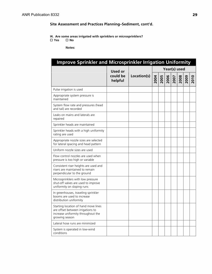
I4. Are some areas irrigated with sprinklers or microsprinklers? Yes No Notes:
Improve Sprinkler and Microsprinkler Irrigation Uniformity Year(s) used
Used or could be helpful
Location(s)
2004
2005
2006
2007
2008
2009
2010
Pulse irrigation is used
Appropriate system pressure is maintained
System flow rate and pressures (head and tail) are recorded
Leaks on mains and laterals are repaired
Sprinkler heads are maintained
Sprinkler heads with a high uniformity rating are used
Appropriate nozzle sizes are selected for lateral spacing and head pattern
Uniform nozzle sizes are used
Flow control nozzles are used when pressure is too high or variable
Consistent riser heights are used and risers are maintained to remain perpendicular to the ground
Microsprinklers with low pressure shut-off valves are used to improve uniformity on sloping runs
In greenhouses, traveling sprinkler booms are used to increase distribution uniformity
Starting location of hand move lines are offset between irrigations to increase uniformity throughout the growing season
Lateral hose runs are minimized
System is operated in low-wind conditions

ANR Publication 8332
30
Site Assessment and Practices Planning–Sediment, cont'd.
Year(s) used
Used or could be helpful
Location(s)
2004
2005
2006
2007
2008
2009
2010
Vegetation is established along field edges to shield from wind
Herbaceous Wind Barrier #603
Windbreak/Shelterbelt #380 & #650
Irrigations are ended if significant runoff occurs
Cover crops are used to enhance soil aggregate structure and improve infiltration
Cover Crop #340

ANR Publication 8332
31
Site Assessment and Practices Planning–Sediment, cont'd.
I5. Are some areas drip irrigated? Yes No Notes:
Improve Drip Irrigation Uniformity Year(s) used
Used or could be helpful
Location(s)
2004
2005
2006
2007
2008
2009
2010
Drip tape and emitters are used with an application rate that matches system design, soil or substrate type, and crop needs
The water supply is evaluated for high bicarbonates that can cause clogging
A filter is selected that filters the mineral and sand particles in the water supply
Filters are regularly flushed/cleaned Lateral lines are flushed regularly Lateral lines are periodically chlorinated to prevent bacterial and algal build-up and root intrusion into emitters
Emitters are regularly checked to ensure they are delivering water to plants
Leaks on mains and laterals are repaired
Emitters with shut-off valves to isolate unused containers or benches are used
Drip tape with a small emitter discharge exponent is used
Pulse irrigation is used A pressure regulator is used for each submain
Pressures of submains are regularly adjusted
Pressure compensating emitters are used
Cover crops are used to enhance soil aggregate structure and improve infiltration
Cover Crop #340

ANR Publication 8332
32
Site Assessment and Practices Planning–Sediment, cont'd.
Managing Pesticides
Pesticide Management Program
P1. Does your pest management program have the potential to impact water quality? Yes No Notes:
Use IPM to Make Informed Pesticide Management Decisions http://www.imp.ucdavis.edu
Year(s) used
Used or could be helpful
Location(s)
2004
2005
2006
2007
2008
2009
2010
Prepare Site and Use Plant Materials to Promote Crop Health Fields are designed or managed to reduce water related stress
Bedding #310
Irrigation Land Leveling #464
Irrigation Water Management #449
Container media is selected to reduce water related stress
Resistant varieties are planted
Crop rotations are used to break pest population cycles
Conservation Crop Rotation #328
Cover crops are used to promote soil health and reduce weeds, insects, and pathogens
Cover Crops #340
Non-cropped areas are managed (planted, paved or mulched) to discourage weeds
Pesticides that move from their site of application into surface or groundwater can affect the beneficial uses of water through their potential impact on human and animal health, and on non-target organisms. Wind and water erosion of soil, or drift from pesticide applications may contribute to pesticide movement away from the target area. Pesticides may enter surface waters in irrigation return flows and tile drainage either as water-soluble residuals or adsorbed to sediments. Groundwaters in agricultural areas may also be subject to pollution from pesticides when deep percolation from irrigated land carries water-soluble pesticides to the groundwater. Many practices in this section fall under NRCS Conservation Practice Standard Pest Management #595. Consult other sources such as the UC Integrated Pest Management (IPM) Pest Management Guidelines for crop-specific IPM practices and alternatives to pesticide use http://www.ipm.ucdavis.edu.

ANR Publication 8332
33
Site Assessment and Practices Planning–Sediment, cont'd.
Year(s) used
Used or could be helpful
Location(s)
2004
2005
2006
2007
2008
2009
2010
Assess Pest Populations UC IPM Pest Management Guidelines are consulted for crop-specific assessment techniques
http://www.ipm.ucdavis.edu
Blocks are scouted regularly for early detection of pests and diseases
"Hot spots" are identified
Records of pests and beneficial insects are maintained
Adopt Cultural Practices for Pest Management Sanitation - Plant material is certified and inspected for vigor, sanitation is practiced when handling plant material and equipment
Pest-ridden and diseased plants are removed or rogued out
Alternate host plants that are non-native and/or not harboring beneficial insects are replaced
Dust from roads onto fields is reduced by mulching graveling, watering down, or treating with an environmentally safe dust suppressant
Access Road #560
Mulching #484
Mechanical weeding such as mowing, tilling, disking, and hand weeding is used whenever practical
Physical or environmental controls are used (changing humidity or temperature in greenhouses, switching to drip irrigation in row crops, etc.)
Pest exclusion is performed in greenhouses

ANR Publication 8332
34
Site Assessment and Practices Planning–Sediment, cont'd.
Year(s) used
Used or could be helpful
Location(s)
2004
2005
2006
2007
2008
2009
2010
Adopt Biological Control Practices for Pest Management Biological controls are used to control pest populations, where possible
Populations of beneficial insects are considered when making pesticide selection
Make Efficient Pest Control Decisions UC IPM Pest Management Guidelines are consulted for alternatives to chemical pest control, or for reduced risk pesticide selections.
http://www.ipm.ucdavis.edu
Compatible pesticides such as selective pesticides are used when beneficial insects are present
Application decisions are based on scouting data, pest thresholds and/or risk assessment models
Pesticides are selected for lower risk of runoff or leaching based upon site conditions, pesticide label warnings, or transport models
www.wcc.nrcs.usda.gov/pestmgt/winpst.html
"Hot spots" are treated independently
Pesticides are applied at the lowest effective labeled rate

ANR Publication 8332
35
Site Assessment and Practices Planning–Sediment, cont'd.
Pesticide Handling P2. Are pesticides stored on site? Yes No Notes: P3. Are pesticides mixed and loaded on site? Yes No Notes: P4. Are pesticides (organic and/or synthetic) applied to crops, including ground applied, foliar applied, and chemigation? Yes No Notes:
Implement Responsible Storage Application and Disposal Practices
Year(s) used
Used or could be helpful
Location(s)
2004
2005
2006
2007
2008
2009
2010
Handle Materials Safely
Pesticide handlers and applicators receive yearly training
Pesticide label instructions and environmental hazard warnings are followed
Application equipment and/or injectors are checked and calibrated regularly
Acreage to be treated and soil types are known
Pesticides sprayers are turned off when equipment is making turns outside of rows
Pesticides are not sprayed when winds could move pesticides off-target as ‘drift’
Greenhouse exhaust fans are turned off during applications
Rain events are considered – pesticides are not applied prior to projected rain events

ANR Publication 8332
36
Site Assessment and Practices Planning–Sediment, cont'd.
Year(s) used
Used or could be helpful
Location(s)
2004
2005
2006
2007
2008
2009
2010
Pesticide applications in ditches occur when water quality impacts are minimal and materials are used that are approved for use near aquatic habitat
Disposal methods are environmentally safe
Design Facilities Appropriately
The pesticide storage facility includes a concrete pad and curb to contain spills and leaks
Production wells are located on elevated, impervious bases and are upslope of pesticide storage and handling facilities
Wellhead protection consists of an impermeable pad, sump or buffer area of 100’ around the wellhead that excludes pesticide handling and pesticide laden drainage
Containment basins are lined to prevent leaching of pesticides
Mixing is performed on low runoff hazard sites – over 100 feet downslope of wells on an impermeable surface
Agrichemical Handling Facility # 702

ANR Publication 8332
37
Site Assessment and Practices Planning–Sediment, cont'd.
Reducing Pesticide Movement
P5. Do the pesticides applied to your crops have the potential to move offsite adsorbed to sediment, in runoff water and/or by leaching? Yes No Notes: P6. Are you aware of pesticides in the soil from historic applications? Yes No Notes:
Reduce Pesticide Movement with Water and Eroding Soil
Year(s) used
Used or could be helpful
Location(s)
2004
2005
2006
2007
2008
2009
2010
Design Field Layout to Minimize Pesticide Movement
The field is shaped to planned grades
Irrigation Land Leveling #464
Land Smoothing #466
Rows are placed on slopes, grades, widths, or on the contour to minimize erosion and runoff
Contour Farming #330
Contour Orchard and other Fruit Area #331
Row Arrangement #557
Manage Field to Reduce Pesticide Movement Bare soil in the field has been covered with vegetation to reduce soil erosion, increase infiltration and build soil organic matter
Conservation Cover #327
Cover Crop #340
Vegetative Barrier #601

ANR Publication 8332
38
Site Assessment and Practices Planning–Sediment, cont'd.
Year(s) used
Used or could be helpful
Location(s)
2004
2005
2006
2007
2008
2009
2010
Plant residues are retained or other materials are applied to the soil or substrate surface
Mulching #484
Residue Management #329
Deep tillage is performed to fracture restrictive soil layers and increase deep percolation where leaching of pollutants to groundwater is not a significant risk
Deep Tillage #324
Irrigations are managed to minimize leaching and runoff
Irrigation Water Management #449
Strips of perennial vegetation are placed along rows farmed on the contour
Contour Buffer Strip #332
A structure to collect sediment containing pesticides is installed and maintained
Sediment Basin #350
Water and Sediment Control Basin #638
Irrigation System, Tailwater Recovery #447
Vegetation is established along the downslope field edge to filter sediment containing pesticides
Conservation Cover #327
Filter Strip #393
A vegetated channel is placed downslope of the field
Grassed Waterway #412

ANR Publication 8332
39
Site Assessment and Practices Planning–Sediment, cont'd.
Managing Nutrients
Nutrient Management Program N1. Do you apply sources of nitrogen (N) and/or phosphorus (P) (fertilizer, compost, manure)? Yes No Notes:
Make Informed Nutrient Management Decisions Year(s) used
Used or could be helpful
Location(s) 20
04
2005
2006
2007
2008
2009
2010
Base Fertilizer Use on Crop Needs N and P requirements are determined for each crop
N and P status of soil amendments or substrate is determined
Well/irrigation water is monitored for N and P levels
Pre sidedress nitrogen testing is used where applicable
Tissue samples are taken for N and P status
All N and P sources (irrigation water, amendments, crop residue, etc.) are considered in a nutrient budget
Use a nutrient budget in determining fertilizer applications
Nutrient sources associated with agricultural production practices include fertilizers and other amendments, nutrients in groundwater used in irrigation, biodegradation of crop residues, agricultural and municipal waste applied to land, and waste generated by animals directly. Nutrients from these sources become pollutants when they are transported offsite into nearby streams and lakes or percolate in excessive amounts to groundwater. Nitrates and phosphates in surface water bodies contribute to eutrophication. Eutrophication leads to increases in aquatic plants and algal blooms that deplete dissolved oxygen, impacting aquatic organisms. Nitrate pollution of groundwater is widespread and a serious problem statewide because of impacts to drinking water. Nitrates are water-soluble and have the potential to leach or to run off in surface water. Phosphates attach to soil particles and have the potential to move offsite with eroding soil. In areas with high concentrations of accumulated soil phosphorus, phosphorus can also be carried off as dissolved phosphate in runoff water. Many practices in this section fall under NRCS Conservation Practice Standard Nutrient Management #590.

ANR Publication 8332
40
Site Assessment and Practices Planning–Sediment, cont'd.
Year(s) used
Used or could be helpful
Location(s)
2004
2005
2006
2007
2008
2009
2010
Make Efficient Fertilizer Decisions Fertilizer application is timed according to crop requirements
Fertigation is used
Split applications are made
A controlled/slow release fertilizer is used alone or with a liquid feed
Nitrogen accumulating species are used for cover cropping
Cover Crop #340
Irrigations are managed to avoid nutrient loss below the rootzone
Irrigation Water Management #449

ANR Publication 8332
41
Site Assessment and Practices Planning–Sediment, cont'd.
Nutrient Handling N2. Are fertilizers stored and/or mixed on site? Yes No Notes: N3. Are fertilizers (organic and/or synthetic) applied to crops, including pre-mixing with soil substrates, ground applied, foliar applied, and fertigation? Yes No Notes:
Implement Responsible Storage, Application, and Disposal Practices
Year(s) used
Used or could be helpful
Location(s)
2004
2005
2006
2007
2008
2009
2010
Handle Materials Safely Application equipment and/or injectors are checked and calibrated regularly
Precision placement is used to apply fertilizer close to roots
Fertilizer handlers and applicators receive training
Rain and irrigation events are considered – Fertilizers are not applied prior to projected rain events or irrigations
Design Facilities Appropriately
The fertilizer storage facility includes a concrete pad and curb to contain spills and leaks
Mixing is performed on low runoff hazard sites – over 100 feet downslope of the well on an impermeable surface
Agrichemical Handling Facility #702

ANR Publication 8332
42
Site Assessment and Practices Planning–Sediment, cont'd.
Reducing Nutrient Movement
N4. Does the fertilizer applied to your crops have the potential to move offsite attached to sediment, in runoff water or by leaching? Yes No Notes:
Reduce Nutrient Movement with Water and Eroding Soil Year(s) used
Used or could be helpful
Location(s)
2004
2005
2006
2007
2008
2009
2010
Field Layout The field is shaped to planned grades
Irrigation Land Leveling #464
Land Smoothing #466
Rows are placed on slopes, grades, widths or on the contour to minimize erosion and runoff
Contour Farming #330
Contour Orchard and other Fruit Area #331
Row Arrangement #557
Plants in poorly drained soil are placed on parallel ridges or ‘beds’
Bedding #310
Manage Field to Reduce Nutrient Movement Bare soil in the field has been covered with vegetation to reduce soil erosion, increase infiltration and build soil organic matter
Conservation Cover #327
Cover Crop #340
Vegetative Barrier #601
Plant residues or other materials are applied to the field soil surface
Mulching #484
Residue Management #329

ANR Publication 8332
43
Site Assessment and Practices Planning–Sediment, cont'd.
Year(s) used
Used or could be helpful
Location(s)
2004
2005
2006
2007
2008
2009
2010
Deep tillage is performed to fracture restrictive soil layers and increase deep percolation where leaching of pollutants to groundwater is not a significant risk
Deep Tillage #324
Irrigations are managed to minimize leaching and runoff
Irrigation Water Management #449
Strips of perennial vegetation are placed along rows farmed on the contour
Contour Buffer Strip #332
A structure to collect sediment containing nutrients is installed and maintained
Irrigation System, Tailwater Recovery #447
Sediment Basin #350
Water and Sediment Control Basin #638
Vegetation is established along the downslope field edge to filter sediment containing nutrients
Conservation Cover #327
Filter Strip #393
Vegetation is placed downslope of the field
Grassed Waterway #412
Constructed Wetland #656

ANR Publication 8332
44
Site Assessment and Practices Planning–Sediment, cont'd.
Nutrient Waste N5. Is there a septic system on the farm or operation? Yes No Notes: N6. Do livestock have access to a waterbody? Yes No Notes: N7. Is there a feedlot, loafing area, or concentration of livestock near a waterbody? Yes No Notes:
Reduce Nutrient Pollution from Human and/or Livestock Waste
Year(s) used
Used or could be helpful
Location(s)
2004
2005
2006
2007
2008
2009
2010
Septic systems are inspected and maintained
Portable toilets are regularly maintained to avoid spills
Livestock are fenced off from waterways
Fence #382
Use Exclusion #472
Livestock are directed away from waterbodies with placement of troughs, salt licks, dusters and/or trails.
Animal Trails or Walkways #575
Prescribed Grazing #528
Watering Facility #614

ANR Publication 8332
45
Site Assessment and Practices Planning–Sediment, cont'd.
Managing Salinity
Salinity Management Program
1. Is salt accumulation from irrigation, fertilizer, and/or amendments a potential problem? Yes No Notes:
Manage Soil Salinity Year(s) used
Used or could be helpful
Location(s)
2004
2005
2006
2007
2008
2009
2010
Manage Salinity from Irrigation Water The salinity of irrigation water is evaluated
The distribution uniformity of the irrigation system is improved or maintained
Appropriate leaching fractions are used
Fields are graded to improve irrigation uniformity
Irrigation Land Leveling #464
Saline wells are decommissioned and alternative water supplies are used
Well Decommissioning #351
Manage Salinity from Fertilizers and Amendments
Fertilizers and amendments that have a low salt index are used
Irrigation water is essential for crop production in the arid and semiarid regions of California. Irrigation water naturally contains a certain amount of dissolved minerals (salts) depending on its source. Typical irrigation water contains a substantial amount of salt. For example a water source with an EC of 1.0 mmho/cm, a quality suitable for irrigation of most crops, contains nearly a ton of salt in every ac-foot of water applied. In some coastal areas, increased groundwater pumping has resulted in salt water intrusion from the ocean, threatening the overall groundwater quality. In areas such as the Salinas Basin, surface water quality degradation of ponds and sloughs has resulted from high salt levels in irrigation return flow.

ANR Publication 8332
46
Site Assessment and Practices Planning–Sediment, cont'd.
Year(s) used
Used or could be helpful
Location(s)
2004
2005
2006
2007
2008
2009
2010
Manage Saline Soils
Soil salinity is evaluated
Gypsum and other calcium containing amendments to reduce the build-up of exchangeable sodium (ESP) are used
Sulfur amendments are used to reduce soil pH
Where leaching of pollutants to groundwater is not a significant risk, deep tillage is used to break-up hardpan layers that prevent salts from leaching
Deep Tillage #324
A tile drain system is used to improve drainage
Subsurface Drain #606
Cover crops are used to improve water infiltration into soil
Cover Crop #340
Amendments are used to improve infiltration (PAM, gypsum, organic amendments)
Anionic Polyacrylamide (PAM) #450
ANR Publication 8332
47
Site Assessment and Practices Planning–Sediment, cont'd.
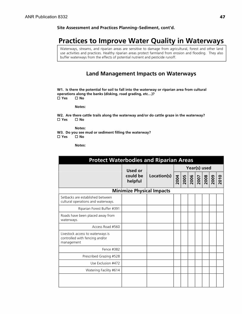
Practices to Improve Water Quality in Waterways
Land Management Impacts on Waterways W1. Is there the potential for soil to fall into the waterway or riparian area from cultural operations along the banks (disking, road grading, etc…)? Yes No Notes: W2. Are there cattle trails along the waterway and/or do cattle graze in the waterway? Yes No Notes: W3. Do you see mud or sediment filling the waterway? Yes No Notes:
Protect Waterbodies and Riparian Areas Year(s) used
Used or could be helpful
Location(s) 20
04
2005
2006
2007
2008
2009
2010
Minimize Physical Impacts Setbacks are established between cultural operations and waterways.
Riparian Forest Buffer #391
Roads have been placed away from waterways.
Access Road #560
Livestock access to waterways is controlled with fencing and/or management
Fence #382
Prescribed Grazing #528
Use Exclusion #472
Watering Facility #614
Waterways, streams, and riparian areas are sensitive to damage from agricultural, forest and other land use activities and practices. Healthy riparian areas protect farmland from erosion and flooding. They also buffer waterways from the effects of potential nutrient and pesticide runoff.

ANR Publication 8332
48
Site Assessment and Practices Planning–Sediment, cont'd.
Year(s) used
Used or could be helpful
Location(s)
2004
2005
2006
2007
2008
2009
2010
Filter Pollutants
A herbaceous vegetative strip is placed between the operation and waterway to filter out pollutants
Conservation Cover #327
Filter Strip #393
Riparian Herbaceous Cover #390
Woody vegetation is planted near the natural waterway to filter out pollutants, reduce erosion, and provide wildlife habitat and shade
Riparian Forest Buffer #391
Channels carrying water from the farm operations to waterways are planted with vegetation to filter out pollutants
Grassed Waterway #412

ANR Publication 8332
49
Site Assessment and Practices Planning–Sediment, cont'd.
Waterway Bank and Channel Management W4. Is there bare soil along banks and/or are there bank sections that are unstable (i.e. vertical banks) due to inadequate vegetation? Yes No Notes: W5. Do you notice the waterway depth is eroding or downcutting? Yes No Notes: W6. Do you notice bank erosion caused by the impacts of bank armoring? Yes No Notes: W7. Does concentrated runoff entering the waterway result in bank erosion or gullies? Yes No Notes:
Stabilize Banks and Channels Year(s) used
Used or could be helpful
Location(s)
2004
2005
2006
2007
2008
2009
2010
Vegetative cover is established on the banks to reduce erosion and enhance habitat
Channel Bank Vegetation #322
Critical Area Planting #342
Streambank Protection #580
Obstructions in the waterway are removed to improve water flow and prevent bank erosion
Clearing and Snagging #326
The channel bed is stabilized to prevent erosion
Grade Stabilization Structure #410
Stream Channel Stabilization #584

ANR Publication 8332
50
Site Assessment and Practices Planning–Sediment, cont'd.
Year(s) used
Used or could be helpful
Location(s)
2004
2005
2006
2007
2008
2009
2010
Structures to convey field drainage water into waterways are installed and maintained
Diversion #362
Grade Stabilization Structure #410
Structure for Water Control #587
Underground Outlet #620

ANR Publication 8332
51
Site Assessment and Practices Planning–Sediment, cont'd.
Waterway Crossings W7. Is the waterway crossing prone to washing out? Yes No Notes: W8. Do you notice channel or bank erosion caused by the impacts of structures such as bridges or crossings? Yes No Notes: W9. Do your culverts have problems with debris buildup or sediment accumulation? Yes No Notes: W10. Do you notice water collecting upstream from culvert inlets during storms? Yes No Notes: W11. Do you see sediment deposited from pooled water above the culvert inlet? Yes No Notes: W12. Do you see debris deposited upstream of the culvert inlet? Yes No Notes: W13. Are there high rust lines in any of the metal culvert pipes (this may indicate undersized pipe)? Yes No Notes: W14. Are any culvert inlet or outlets crushed, torn, jagged or with worn through bases? Yes No Notes: W15. Is there the potential for water to run down the road when the culvert plugs? Yes No Notes:

ANR Publication 8332
52
Site Assessment and Practices Planning–Sediment, cont'd.
W16. Is the water that comes out of the culvert undercutting the road banik or scouring the channel downstream? Yes No Notes:
Protect Waterway Crossings Year(s) used
Used or could be helpful
Location(s)
2004
2005
2006
2007
2008
2009
2010
Road crossing and culverts have been assessed for proper flows and channel grades
Access Road #560
Structure for Water Control #587
Stream banks are stabilized with vegetation and/or structural measures to reduce erosion
Channel Vegetation #322
Critical Area Planting #342
Streambank Protection #580
Obstructions are removed to improve water flow and reduce bank erosion
Clearing and Snagging #326
Channel crossings and culverts are sized, placed, and maintained to provide a stable channel grade
Stream Channel Stabilization #584
Structure for Water Control #587
Undersized, worn/compacted, or improperly placed culverts are replaced
Structure for Water Control #587
Energy dissipaters are installed below culverts to prevent scouring

ANR Publication 8332
53
Site Assessment and Practices Planning–Sediment, cont'd.
Stream Habitat W12. Are sections of streamflow exposed to sun for more than half the day? Yes No Notes: W13. Are there potential impediments to fish passage in the stream? Yes No Notes: W14. Do you notice the encroachment of non-native invasive plant species and/or the loss of native riparian or wetland habitat? Yes No Notes:
Maintain or Improve Stream Habitat Year(s) used
Used or could be helpful
Location(s)
2004
2005
2006
2007
2008
2009
2010
Vegetative cover is established along banks to reduce erosion and enhance habitat
Channel Bank Vegetation #322
Riparian Forest Buffer #391
Riparian Herbaceous Cover #390
Tree/Shrub Establishment #612
Wetland Wildlife Habitat Management #644
Invasive plant species are identified, removed and replaced with native species
Restoration and Management of Declining Habitats #643
Stream conditions are improved for aquatic species
Irrigation Storage Reservoir #436
Obstruction Removal #500
Barriers that restrict or prevent fish migration are removed
Fish Passage #396

ANR Publication 8332
54
SELF-EVALUATION
An essential element of a water quality site self-assessment is the tracking of land use and management activities on your agricultural operation. Self-evaluation data that you can provide can be important in explaining any water quality changes that may occur due to implementation of management practices. Self-evaluation techniques can help determine whether water quality changes can be attributed to implementing management practices and not to other confounding influences such as regional geology or a source upstream of the operation. Simple field measurements are often undervalued and suspected of lacking scientific validity. When properly designed and carefully executed, however, they can provide sound data. Their strength lies in the possibility of taking large numbers of measurements inexpensively and with only semi-skilled assistance to obtain results that are more pertinent to your site than sophisticated measurements taking place at some distant monitoring station.
Record Keeping Keep with Plan for reference
Do you keep a record of: � weather conditions such as air temperature, precipitation, and evapotranspiration � extreme weather events such as severe storms, floods, and droughts � natural vegetation and/or wildlife observations � grazing (animal numbers, in and out pasture dates) � natural vegetation and/or wildlife observations
Photo Point Self-Evaluation Keep photos and historic records with Plan for reference
Do you have any historic records and/or photographs that can help you document short or long term changes on the farm/ranch? � Yes � No
How many photo points are on your farm/ranch?
How many times per year will photographs be taken?
Other Self-Evaluation Techniques You Perform or Plan to
Perform Keep with Plan for reference
Technique Location(s) Dates or Schedule
Sediments
� Erosion Pins
� Erosion Pipes
� Estimating Streambank Loss
� Imhoff Cones
� Paint Collars � Sediment Basin or Sand Trap - (record amount of sediment removed)
� Staking Gullies or Streambanks
� Walking the Runoff
�

ANR Publication 8332
55
Self-Evaluation, cont'd.
Nutrients
� Drainage Water Analysis
� Irrigation Water Analysis
� Plant Tissue Analysis
� Record Fertilizer Use
� Soil Analysis
� Utilize Crop Budgets
�
Pesticides
� Monitor for Pests and Beneficial Insects
� Review Use Reports
� Assess Risk of Pesticide Loss
�
Riparian Habitat
� Percent Bare Soil Along Banks
� Percent Canopy Cover over Stream
� Staking Gullies or Streambanks
� Streambank Erosion Measurements
� Walking the Runoff
�
Surface Water Quality
� Ammonia
� Conductivity
� Dissolved Oxygen (DO)
� Nitrate
� pH
� Phoshpates
� Rapid Bioassessment Technique
� Stream Flow
� Stream Temperature
� Stream Turbidity
�

ANR Publication 8332
56
Self-Evaluation, cont'd.
Irrigation/Groundwater Quality
� Electroconductivity (EC)
� Nutrient Levels in Irrigation or Well Water (N, P, Na)
� pH
� Sodium Adsorption Ratio (SAR) or adjusted SAR
� Toxicity Levels in Irrigation water (Sodium, Cl, B)
�
Tailwater/Ditch Drainage Water Quality
� Effluent flow
� Electroconductivity (EC)
� Nutrient Levels in Drainage Water
(N, P, Na)
� pH
� Turbidity
�

REFERENCES Much of the information in the Farm Water Quality Plan has been adapted from the RanchWater Quality Management Plan created by University of California Cooperative Extensionand the USDA Natural Resources Conservation Service (unpublished).
Some practices in the Site Assessment and Practices Planning section were adapted fromProduction guide: Nitrogen and water management for coastal cool-season vegetables. 1998. G. S.Pettygrove, et al., Division of Agriculture and Natural Resources, University of California,Oakland CA; Farm-A-Syst farmstead assessment system, University of Wisconsin–Extensionhttp://www.uwex.edu/farmasyst; and The Positive Points System, Central Coast Vineyard Teamhttp://www.vineyardteam.org/pps/index.htm.
Numbered practices in the Site Assessment and Practices Planning section refer toUSDA–NRCS National handbook of conservation standards. Individual practices can be found athttp://www.ftw.nrcs.usda.gov/nhcp_2.html.
Site Assessment and Practices Planning questions E7 through E11 adapted from Downie,Scott, Dennis Halligan and Ross Taylor. 1998. Watershed processes and erosion control: A work-book and compendium. Fish, Farm, and Forest Communities Forum.
ACKNOWLEDGMENTSThe editors and workgroup wish to acknowledge Julie Fallon, Farm Water Quality ProjectProgram Representative, for her commitment, creativity, and tenacity in the development ofthe Farm Water Quality curriculum and in particular the Template Farm Water Quality Plan.Julie guided every publication in the curriculum from peer review to publication while incor-porating input form researchers, technical staff, and growers. Our thanks and appreciation toher for her work.
NPS Pollutant Information CollaboratorsThe following provided technical information in the Site Assessment and Practices Planningsection for these specific areas:
Basin water quality information
Lisa McCann, Central Coast Regional Water Quality Control BoardAmanda Bern, Central Coast Regional Water Quality Control BoardMark Angelo, Central Coast Regional Water Quality Control Board
Managing sediment
Giulio Ferruzzi, USDA–NRCS
Managing irrigation
Michael Cahn, UCCE Monterey CountyThomas Harter, UCCE Davis
Managing pesticides
Giulio Ferruzzi, USDA–NRCSJay Gan, UCCE RiversideWilliam Chaney, UCCE Monterey County
Managing nutrients
Giulio Ferruzzi, USDA–NRCSManaging salinity
Michael Cahn, UCCE Monterey CountyGiulio Ferruzzi, USDA–NRCS
Practices to improve water quality in waterways
Giulio Ferruzzi, USDA–NRCSJohn Warner, USDA–NRCSRichard Casale, USDA–NRCS
4 6ANR Publication 8332

Self-evaluation
Terry Hall, USDA–NRCS
Commodity Information CollaboratorsThe following provided technical information in the Site Assessment and Practices Planningsection for these commodities:
Cool-season vegetables
Richard Smith, UCCE Monterey CountyTim Hartz, UCCE Davis
Greenhouse/nursery
Ann King, UCCE San Mateo CountyJohn Kabashima, UCCE South Coast Research and Extension CenterDarren Haver, UCCE Orange CountyRichard Evans, UCCE DavisAziz Baameur, UCCE Santa Clara CountyJulie Newman, UCCE Ventura CountyLoren Oki, UCCE DavisSteve Tjosvold, UCCE Santa Cruz CountyJ. Heinrich Lieth, UCCE Davis
Orchards and vineyards
Ben Faber, UCCE VenturaMark Battany, UCCE San Luis Obispo County
Strawberries and caneberries
Mark Bolda, UCCE Santa Cruz County
ReviewersSpecial thanks for review of Farm Water Quality Plan sections –
Mel George, UCCE DavisMichael Isensee, UCCE San Luis Obispo CountyRoyce Larson, UCCE San Luis Obispo CountyMargy Lindquist, USDA–NRCSDan Johnson, USDA–NRCSRebecca Challender, USDA–NRCSRobert Fry, USDA–NRCSAlbert Cerna, USDA–NRCSDavid Robledo, USDA–NRCSTina Vander Hoek, USDA–NRCSMarc Los Huertos, UC Santa CruzMike Hill, California Department of Fish and Game
The Farm Water Quality Working Group would like to thank the growers from
Chualar/Quail Watershed Group Pilot Course January 2001, Monterey CountyLos Osos/Chorro Watershed Group Pilot Course February 2001, San Luis Obispo CountyPescadero/Butano Watershed Group Pilot Course June 2001, San Mateo County
for contributions instrumental in the development of the Farm Water Quality Planning curricu-lum. Their participation and suggestions were invaluable in the process of building this finalproduct.
Additionally we wish to acknowledge the efforts of Carolyn Richardson, whose energy and dedi-cation is greatly missed.
4 7ANR Publication 8332

4 8ANR Publication 8332
The Farm Water Quality Plan has been made possible with funding through:
USDA Cooperative State Research, Education, and Extension Service Water Quality Program 1999-2000
David and Lucille Packard Foundation Conserving California Landscapes Initiative 2000-2001
DANR Water Quality Workgroup Farm Water Quality Task Force 2000-2003California State Water Resources Control Board Section 319(h) Grant Program
2001-2004
FOR MORE INFORMATIONYou’ll find detailed information on many aspects of resource conservation in thesetitles and in other publications, slide sets, CD-ROMs, and videos from UC ANR:
Farm Water Quality Planning Short Course Objectives, publication 8052
Nonpoint Sources of Pollution in Irrigated Agriculture, publication 8055
Practices for Reducing Nonpoint Source Pollution from Irrigated Agriculture, publication 8075
To order these products, visit our online catalog at http://anrcatalog.ucdavis.edu. Youcan also place orders by mail, phone, or fax, or request a printed catalog of publica-tions, slide sets, CD-ROMs, and videos from
University of CaliforniaAgriculture and Natural ResourcesCommunication Services6701 San Pablo Avenue, 2nd FloorOakland, California 94608-1239
Telephone: (800) 994-8849 or (510) 642-2431, FAX: (510) 643-5470e-mail inquiries: [email protected] electronic version of this publication is available on the ANR CommunicationServices website at http://anrcatalog.ucdavis.edu.
Publication 9002
© 2004 by the Regents of the University of California, Division of Agriculture and NaturalResources. All rights reserved.
The University of California prohibits discrimination against or harassment of any personemployed by or seeking employment with the University on the basis of race, color, nationalorigin, religion, sex, physical or mental disability, medical condition (cancer-related or geneticcharacteristics), ancestry, marital status, age, sexual orientation, citizenship, or status as a cov-ered veteran (special disabled veteran, Vietnam-era veteran or any other veteran who served onactive duty during a war or in a campaign or expedition for which a campaign badge has beenauthorized).
University Policy is intended to be consistent with the provisions of applicable State andFederal laws.
Inquiries regarding the University’s nondiscrimination policies may be directed to theAffirmative Action/Staff Personnel Services Director, University of California, Agriculture andNatural Resources, 300 Lakeside Drive, 6th Floor, Oakland, CA 94612-3550 (510) 987-0096.For information about obtaining this publication, call (800) 994-8849.
pr-3/04-WJC/CR
This publication has been anonymously peer reviewed for technical accuracy by University of Californiascientists and other qualified professionals. This review process was managed by the ANR AssociateEditor for Natural Resources.