Embed Size (px)
Citation preview
MILLIGAN, HOLMES & DAVIS Landscape Research Record No. 4
The authors are solely responsible for the content of this technical presentation. The technical presentation does not necessarily reflect the official position of the Council of Educators in Landscape Architecture (CELA), and its printing and distribution does not constitute an endorsement of views which may be expressed. Technical presentations are not subject to the formal peer review process by CELA Track Chair System; therefore, they are not to be presented as peer-reviewed publications. Citation of this work should state that it is from a CELA conference paper. EXAMPLE: Author's Last Name, Initials. 2014. Title of Presentation. CELA Paper No. 14-xxxx. Baltimore, Maryland: CELA. For information about securing permission to reprint or reproduce a technical presentation, please contact CELA at [email protected] or 817-272-2321.
THE FORCE OF THINGS: LANDSCAPE DESIGN AND THE PANAMA CANAL
MILLIGAN, BRETT University at California-Davis, [email protected] HOLMES, ROB University of Florida, [email protected] DAVIS, BRIAN Cornell University, Ithaca, NY, [email protected] 1 ABSTRACT Ports and shipping canals are landscapes of utmost importance—geopolitically, economically, logistically, and ecologically. They are continually evolving landscapes, distributed globally and culturally significant. Despite this, the discipline of landscape architecture does not have a history of deep engagement with this landscape type. The Panama Canal offers an instructive example. This paper provides a historical and theoretical account of the construction of the Panama Canal—including locks, channels, displaced populations, the urbanized Canal Zone, and the instrumentalized watershed—as a landscape. Using Frederick Law Olmsted’s and Daniel French’s 1913 Report to the Fine Arts Commission as a starting point, and drawing from historical accounts, technical literature and contemporary theory, our analysis places cultural and natural forces on inseparable and equal footing. From this historical and theoretical investigation, this paper traces one pervasive characteristic of these maritime infrastructures, “feedback”. We argue that feedback both demonstrates the importance of direct engagement with maritime infrastructures by landscape architects and can be deployed as a conceptual tool to facilitate such engagement. 1.1 Keywords
Panama Canal, landscape infrastructure, large technical systems, Frederick Law Olmsted, Jr., ports, canals
MILLIGAN, HOLMES & DAVIS Landscape Research Record No. 4
74
2 INTRODUCTION On October 22, 2006, the citizens of Panama approved the Panama Canal Expansion (Lacy,
2006), an infrastructural mega-project that is doubling the capacity of the Canal, the world’s most central and second most heavily trafficked (Kaluza 2010), trailing only the Suez. All along the coasts of North and South America ports are working to complete their own expansions – deeper channels and longer berths, larger shipping cranes and new container yards – with the goal of being able to receive the ultra-large ships that will begin transiting the Canal in 2016.
In recent decades there has been much interest in the topic of landscape infrastructure. This can be seen in influential contemporary work such as that of Pierre Belanger (2009, 2013), Alan Berger (2009), Sonja Duempelmann (2010) or Kristina Hill (Stevens, et al, 2014), as well as earlier writings by Michael Hough (1995), Gary Strang (1996), and Rob Thayer (1994), among many others [1]. As this trajectory takes shape in the field of landscape architecture, it can be understood in part as a response to the effects of now-rapidly changing climatic, ecological and economic conditions (Waldheim and Berger 2008). But it is also a response to the conceptual and material limitations of many of the roads, ports, electrical grids, levees and hydroelectric dams from an earlier generation of infrastructure, as well as the unintended consequences resulting from their construction, operation, and deterioration (Bélanger 2013).
As some landscape architects respond to contemporary conditions by turning toward infrastructure, the study of ports and shipping canals should emerge as an object of interest. These are places of globally significant impact—geopolitically, economically, logistically, and ecologically. As an infrastructural interface between land and water, they materialize processes of labor and flows of capital, dynamics of sedimentation and hydrology, and powerfully bind economic policy and technology with an industrial legacy of toxicity and environmental change. Landscape architects should be a part of the discourse around these maritime infrastructures, both learning from and contributing to them. But, in order to do so, we will need to grapple with both our own disciplinary history and the range of forces that shape ports and canals.
In this paper we attempt to begin that process by excavating a historical link between the discipline and a prominent infrastructural maritime landscape, the Panama Canal. We then mesh this with examination of certain periods of the history of the Panama Canal, contemporary theory, and landscape architectural practice to explore a conceptual tool – “feedback” – that landscape architecture can use to engage with these very large and expanding landscapes. Drawing on complex systems theory, we use feedback to describe nonlinear landscape change, where outputs become inputs, leading to processes of rapid aggregation, which in turn leads to qualitative changes of state. 3 THE CANAL REPORT
One of the important contributions of theoretical and historical projects that have dealt with landscape architecture, urbanism and infrastructure has been to identify earlier practices and theories in those fields that did similar work, albeit in a different form and using a different vocabulary. Contemporary revisionist histories by Anne Whiston Spirn (Spirn 1996), Elizabeth Meyer (Meyer 1997), and others have allowed for a critical reexamination of the work of Cleveland, Eliot, MacKaye, and Olmsted. In particular, such histories have examined the way some of their major public projects functioned as public infrastructural systems (Waldheim 2006, 39). These excavations have aided in the recovery and development of conceptual tools that are proving important to contemporary efforts to rethink and reconstruct infrastructure as landscape The work of Frederick Law Olmsted, Jr. in Panama offers a similar starting point that is specific to the maritime infrastructures this paper is concerned with. As part of the 1912 Panama Canal Act, the Fine Arts Commission was to produce a report for the President of the United States “regarding the artistic character of the structures of the canal” (United States 1913, 5). As Vice Chairman of this commission Olmsted, Jr. went down to see the works of the Canal, along with the chairman and sculptor Daniel French, and to make recommendations as to its aesthetic qualities and any modifications that should be undertaken on the Canal works before it was completed. Their report was submitted July 26th of the following year, and ran in the New York Times that October (French 1913). In it Olmsted and French interpret their charge to report on the artistic character of canal structures to extend far beyond ornamentation and beautification. Indeed, they dispense with that role at the start, beginning with the succinct judgment that anticipated the more well-known ideas put forth by Le Corbusier nearly two decades later (Corbusier 1931): “the canal itself and all the structures connected with it impress one with a
MILLIGAN, HOLMES & DAVIS Landscape Research Record No. 4
75
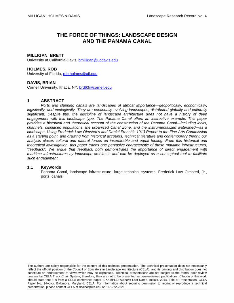
sense of their having been built with a view strictly to their utility… like the Pyramids or some imposing object in natural scenery, [it] is impressive from its scale and simplicity and directness” (French 1913) [Figure 1]. This effect is similar to that identified by historian David Nye as the geometrical form of the technological sublime, which he described as “static and [appearing] to dominate nature through elegant design and sheer bulk.” Citing the engineer John Roebling, Nye noted that structures of this type were intended to have “very graceful, simple but at the same time substantial appearance[s]… and [were] intended to be unique and striking in [their] effect and quite in keeping with the surrounding scenery.” (Nye 1994, 77-78).
Figure 1. Bird’s eye view of Gatun Locks, Panama Canal, ca. 1913; note the sublime aesthetic quality of the locks themselves. Photo from the Library of Congress. No restrictions on publication that falls under fair use.
In addition to describing the existing monumental infrastructures in a way that offered a fully-formed modern aesthetic vision, the work of Olmsted, Jr. and French showed a genuine concern with the functioning of the ports and the canal, and the integration of the new infrastructures and concomitant urban development into the existing and projected regional landscape (United States 1913, 8). After a general analysis, they proceed to make recommendations for specific landscapes or projects such as the layout and future development to the port of Cristobal, and the town of Colon:
Cristobal is being completely enclosed with wharves upon which it is planned to erect continuous sheds, entirely cutting off the view of the town from the water. It will make the town more agreeable to live in and will enhance the appearance from the bay if the space now open at Dock 15, between the end of the present shed of Dock 11 and the southeast end of Dock 16, can be kept permanently open and free from sheds. The desirability of this is undoubted if it is found to be practicable.” (United States 1913, 9).
In this quote Olmsted and French acknowledge the importance of economic and engineering directives while asserting that attention should be paid to living conditions and visual connections across the landscape. Their recommendations reveal an interest in establishing reciprocal relationships between the land and the sea, the port town and the harbor, often through visual connections.
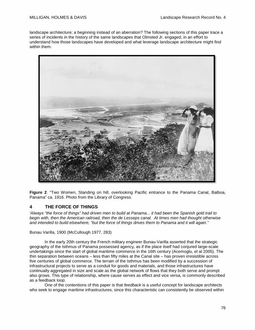
Throughout the document, integrating the landscapes of labor and recreation in rational and aesthetically pleasing ways is a primary objective, leading to some surprising conclusions. Regarding the design and future use of four small islands just off the Pacific coast, and the infrastructural network of causeways and dikes connecting them to the mainland [Figure 2] they write:
“These islands are connected with each other and with the mainland by dikes or causeways… it has been proposed to plant [the causeway road] with trees throughout its entire length. If the trees were planted near enough together to shade the road effectively they would completely shut out from the ships entering or leaving the canal the view of the city, which at present is very attractive… and they would tend to make the shore continuous with the island, and thus destroy the effect of its being an island. We therefore doubt the wisdom of such tree planting. It may be possible to plant groups of trees, presumably palms, near the ends of the causeway without impairing its effect… This should be carefully considered.” (United States 1913, 11).
While now serving as little more than a historical footnote, this document suggests the question of what could have happened if this report by Frederick Law Olmsted, Jr. and Daniel French had been the start of a long-term engagement with ports, canals, and other maritime infrastructure in the profession of
MILLIGAN, HOLMES & DAVIS Landscape Research Record No. 4
76
landscape architecture; a beginning instead of an aberration? The following sections of this paper trace a series of incidents in the history of the same landscapes that Olmsted Jr. engaged, in an effort to understand how those landscapes have developed and what leverage landscape architecture might find within them.
Figure 2. “Two Women, Standing on hill, overlooking Pacific entrance to the Panama Canal, Balboa, Panama” ca. 1916. Photo from the Library of Congress.
4 THE FORCE OF THINGS ‘Always “the force of things” had driven men to build at Panama... it had been the Spanish gold trail to begin with, then the American railroad, then the de Lesseps canal. At times men had thought otherwise and intended to build elsewhere, “but the force of things drives them to Panama and it will again.”
Bunau Varilla, 1900 (McCullough 1977, 283)
In the early 20th century the French military engineer Bunau-Varilla asserted that the strategic
geography of the Isthmus of Panama possessed agency, as if the place itself had conjured large-scale undertakings since the start of global maritime commerce in the 16th century (Acemoglu, et al 2005). The thin separation between oceans – less than fifty miles at the Canal site – has proven irresistible across five centuries of global commerce. The terrain of the Isthmus has been modified by a succession of infrastructural projects to serve as a conduit for goods and materials, and those infrastructures have continually aggregated in size and scale as the global network of flows that they both serve and prompt also grows. This type of relationship, where cause serves as effect and vice versa, is commonly described as a feedback loop.
One of the contentions of this paper is that feedback is a useful concept for landscape architects who seek to engage maritime infrastructures, since this characteristic can consistently be observed within
MILLIGAN, HOLMES & DAVIS Landscape Research Record No. 4
77
these landscapes, at the full range of scales at which they operate and materially manifest. In order to demonstrate this, we present three examples of feedback related to the Panama Canal, in ascending chronology and scale. The first example is material, and concerns the excavation of the original American canal route. The second example is territorial and occurs primarily between the original excavation and the current Expansion Project. Finally, the third example concerns the networked logistical effects of the Expansion at a hemispheric scale. 4.1 The Culebra Cut
The highest and most difficult portion of the original Canal project was known as the Culebra Cut. This ran through the saddle between two mountains on the Continental Divide. There the Divide is not the hard, stable basalts and schists of the lower elevations, but is a plate of soft shales, sandy limestone and calcareous sandstones over top of a basalt core. These softer stones were heaved and smashed together by plate subduction and volcanic activity beginning during the Miocene Era 20 million years ago. Consequently, that particular section demanded the greatest amount of excavation through the least stable geology at the highest elevation.
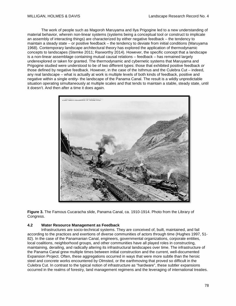
The volume of excavation initially required at the Culebra Cut was astronomical, a feat of earth-moving that required entirely new tools and techniques on a massive scale. In 1905 a newly designed ninety-five ton steam shovel built by the Bucyrus Company of Milwaukee began working in the Cut, a machine three times the size of the excavators used by the French in the same location. The techniques devised included an extremely careful choreography of drilling and blasting compacted rock, excavating spoils with the massive steam shovels, and loading them onto waiting dirt trains where they were then carted off to one of sixty engineered dump sites. On any given day during peak excavation, one hundred and sixty trains were hauling sixty thousand cubic yards of excavated dirt out of the Cut along seventy-six miles of track organized on seven levels. This track was constantly being removed and relocated to new excavating positions by teams of workers as the shovels worked their way through the blasted rock. By 1907, seventy-seven of the Bucyrus machines were among the shovels working to excavate over 96,000,000 cubic yards from the Continental Divide (McCullough 1977, 546-547).
Despite the sophisticated choreography of excavation and railroad technology employed in this task, the difficult geology of the Culebra Cut continually presented unexpected surprises. Because the soft surficial material of the Divide rested on a core of hard basalt, it was highly prone to sliding downhill when saturated. During the French effort it had been this Cut that had halted all progress. The technological historian David McCullough’s description offers a useful insight:
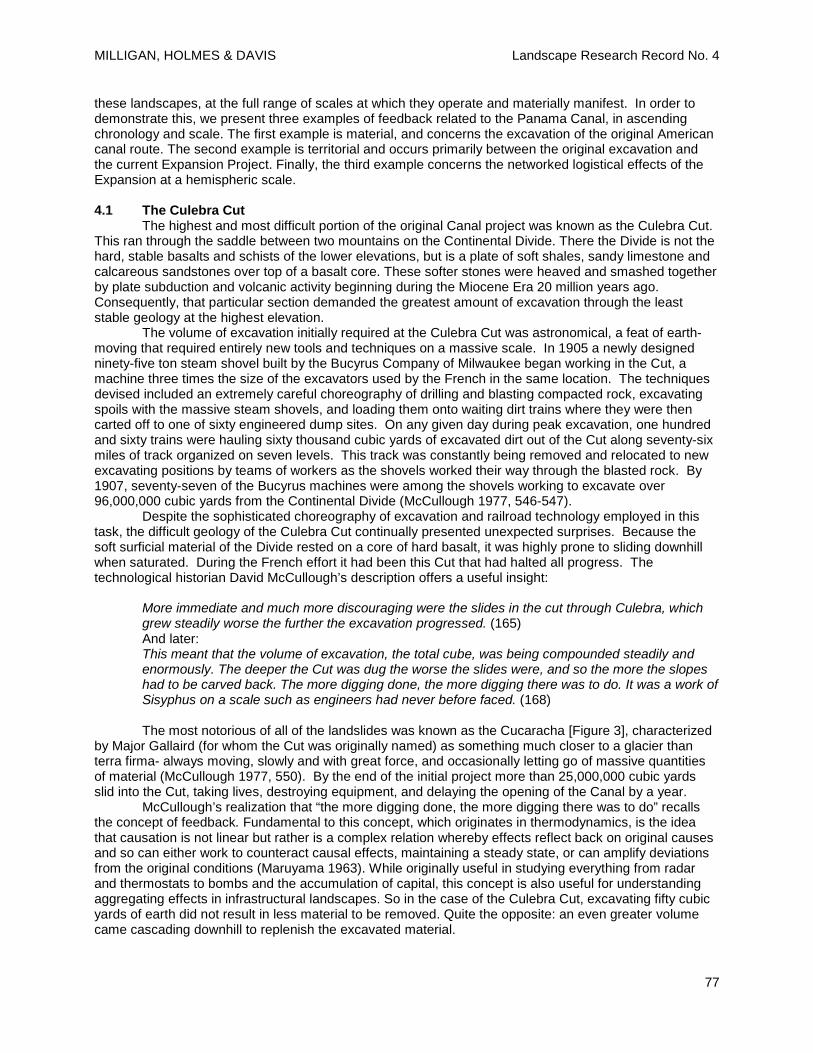
More immediate and much more discouraging were the slides in the cut through Culebra, which grew steadily worse the further the excavation progressed. (165) And later: This meant that the volume of excavation, the total cube, was being compounded steadily and enormously. The deeper the Cut was dug the worse the slides were, and so the more the slopes had to be carved back. The more digging done, the more digging there was to do. It was a work of Sisyphus on a scale such as engineers had never before faced. (168) The most notorious of all of the landslides was known as the Cucaracha [Figure 3], characterized
by Major Gallaird (for whom the Cut was originally named) as something much closer to a glacier than terra firma- always moving, slowly and with great force, and occasionally letting go of massive quantities of material (McCullough 1977, 550). By the end of the initial project more than 25,000,000 cubic yards slid into the Cut, taking lives, destroying equipment, and delaying the opening of the Canal by a year.
McCullough’s realization that “the more digging done, the more digging there was to do” recalls the concept of feedback. Fundamental to this concept, which originates in thermodynamics, is the idea that causation is not linear but rather is a complex relation whereby effects reflect back on original causes and so can either work to counteract causal effects, maintaining a steady state, or can amplify deviations from the original conditions (Maruyama 1963). While originally useful in studying everything from radar and thermostats to bombs and the accumulation of capital, this concept is also useful for understanding aggregating effects in infrastructural landscapes. So in the case of the Culebra Cut, excavating fifty cubic yards of earth did not result in less material to be removed. Quite the opposite: an even greater volume came cascading downhill to replenish the excavated material.
MILLIGAN, HOLMES & DAVIS Landscape Research Record No. 4
78
The work of people such as Magoroh Maruyama and Ilya Prigogine led to a new understanding of material behavior, wherein non-linear systems (systems being a conceptual tool or construct to implicate an assembly of interacting things) are characterized by either negative feedback – the tendency to maintain a steady state – or positive feedback – the tendency to deviate from initial conditions (Maruyama 1968). Contemporary landscape architectural theory has explored the application of thermodynamic concepts to landscapes (Stemke 2011; Raxworthy 2014). However, the specific concept that a landscape is a non-linear assemblage containing mutual causal relations – feedback – has remained largely underexplored or taken for granted. The thermodynamic and cybernetic systems that Maruyama and Prigogine studied were understood to be of two different types: those that exhibited positive feedback or those defined by negative feedback. However, in the case of the Isthmus and the Culebra Cut – indeed, any real landscape – what is actually at work is multiple levels of both kinds of feedback, positive and negative within a single entity- the landscape of the Panama Canal. The result is a wildly unpredictable situation operating simultaneously at multiple scales and that tends to maintain a stable, steady state, until it doesn’t. And then after a time it does again.
Figure 3. The Famous Cucaracha slide, Panama Canal, ca. 1910-1914. Photo from the Library of Congress.
4.2 Water Resource Management as Feedback
Infrastructures are socio-technical systems. They are conceived of, built, maintained, and fail according to the practices and exertions of diverse communities of actors through time (Hughes 1997, 51-82). In the case of the Panamanian Canal, engineers, governmental organizations, corporate entities, local coalitions, neighborhood groups, and other communities have all played roles in constructing, maintaining, derailing, and radically altering its infrastructural landscapes over time. The infrastructure of the Panama Canal grew multiple times between initial construction and the current, well-documented Expansion Project. Often, these aggregations occurred in ways that were more subtle than the heroic steel and concrete works encountered by Olmsted, or the earthmoving that proved so difficult in the Culebra Cut. In contrast to the typical notion of infrastructure as “hardware”, these subtler expansions occurred in the realms of forestry, land management regimens and the leveraging of international treaties.
MILLIGAN, HOLMES & DAVIS Landscape Research Record No. 4
79
One realm in which we can observe these softer infrastructural expansions is in the provision of water for the canal, from the time it was built to the present.
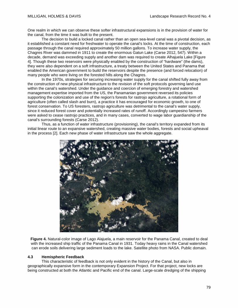
The decision to build a locked canal rather than an open sea-level canal was a pivotal decision, as it established a constant need for freshwater to operate the canal’s locks. At the time of construction, each passage through the canal required approximately 50 million gallons. To increase water supply, the Chagres River was dammed in 1911 to create the enormous Gatun Lake (Carse 2012, 547). Within a decade, demand was exceeding supply and another dam was required to create Alhajuela Lake [Figure 4]. Though these two reservoirs were physically enabled by the construction of “hardware” (the dams), they were also dependent on a soft infrastructure, a treaty between the United States and Panama that enabled the American government to build the reservoirs despite the presence (and forced relocation) of many people who were living on the forested hills along the Chagres.
In the 1970s, strategies for securing increasing water supply for the canal shifted fully away from the construction of new physical infrastructure to the revision of the soft protocols governing land use within the canal’s watershed. Under the guidance and coercion of emerging forestry and watershed management expertise imported from the US, the Panamanian government reversed its policies supporting the colonization and use of the region’s forests for rastrojo agriculture, a rotational form of agriculture (often called slash and burn), a practice it has encouraged for economic growth, to one of forest conservation. To US foresters, rastrojo agriculture was detrimental to the canal’s water supply, since it reduced forest cover and potentially increased rates of runoff. Accordingly campesino farmers were asked to cease rastrojo practices, and in many cases, converted to wage labor guardianship of the canal’s surrounding forests (Carse 2012).
Thus, as a function of water infrastructure (provisioning), the canal’s territory expanded from its initial linear route to an expansive watershed, creating massive water bodies, forests and social upheaval in the process [2]. Each new phase of water infrastructure saw the whole aggregate.
Figure 4. Natural-color image of Lago Alajuela, a main reservoir for the Panama Canal, created to deal with the increased ship traffic of the Panama Canal in 1931. Today heavy rains in the Canal watershed can erode soils delivering large sediment loads to the lake. Satellite photo from NASA. Public domain.
4.3 Hemispheric Feedback
This characteristic of feedback is not only evident in the history of the Canal, but also in geographically expansive form in the contemporary Expansion Project. For that project, new locks are being constructed at both the Atlantic and Pacific end of the canal. Large-scale dredging of the shipping
MILLIGAN, HOLMES & DAVIS Landscape Research Record No. 4
80
channel through the Isthmus is underway in order to accommodate the larger ships necessitated by the New Panamax specifications, which will allow ships of nearly triple the original capacity to pass through its locks. It is estimated that around 150 million cubic meters of earth are being moved during the project (Alfaro 2012), a number that is fully half the excavation required by the original Canal project. This effort is requiring the mobilization of an impressive array of tools, technical expertise, and political decisions not only to cut and move the earth, and to construct the new locks, but also flotillas of support vessels, pipes and tractors and barges disposing of or stockpiling excavations, all while the original Canal structures continue operations. Such an intense concentration of construction machinery, organizational intent, and financial muscle has not operated within the canal landscape since the completion of the original excavations (ACP 2006).
But the transformations are not limited to Panama. Long before the first cubic meter of the Isthmus was excavated – and with the first New Panamax transit still years away – speculations and grand prognostications on exactly how these logistical reconfigurations would affect the global choreography of contemporary material shipments proliferated, gaining momentum with each completed milestone of construction (IWR 2012). This speculative feedback is causing an engineering shockwave to expand outward from the expanded canal, manifesting as upgrades and expansion for the complex network of waterways, ports, inspection stations, railroads, switching yards, highways, warehouses, and distribution centers hosting the global flow and movement of materials shipped through the canal. Importantly, this distributed network of new infrastructures is not waiting to be built after the expansion is complete. Rather, construction in Panama and construction across the Americas is occurring in parallel. As a result, the network and the canal are caught in an aggregating feedback circuit, where the construction of the canal puts pressure on ports to upgrade and the port expansion puts pressure on the canal to expand. 4.4 Bifurcations
Each of these examples – earthmoving and sliding rock in the Culebra Cut, the territorial aggregation of watersheds to supply water to the canal, and the contemporary Expansion project with its engineering shockwave – not only demonstrates the presence of feedback effects in the landscapes of a maritime infrastructure, but also illustrate moments of critical transformation and transition for those landscapes. At these moments, the maritime infrastructure’s landscapes has been radically reshaped as the accumulated pressures of feedbacks are released in a much shorter span of time than it typically took for those pressures to mount.
In his attempt to offer a materialist history of human settlement, Manuel DeLanda develops the concept of “bifurcation”, which offers one definition by which these key moments within a feedback cycle can be described. Borrowed from thermodynamics and mathematics, bifurcations describe the critical points when nonlinear systems – the kind of systems that are characterized by the feedback effects that Maruyama and Prigogine identified – switch from one stable state to another. At these points, “minor fluctuations may play a crucial role in deciding the outcome”, producing much greater systemic consequences than the scale of the fluctuation itself would seem to predict (DeLanda 1997, 1). This seems quite similar to what we see in the three examples presented here. For instance, in the current case of the Expansion Project, the expansion itself has been prompted by the gradual buildup of pressure from changes that arise from network effects, from the gradual accumulation of minor fluctuations – a gradual increase in global shipping volumes, the erosion of the canal’s competitive advantages – not the sudden decisions of any single actor.
Deploying this concept in relation to infrastructural landscapes suggests that identifying potential bifurcations, via scenario planning or other speculative means, and precipitating or staging certain influential minor fluctuations might offer the possibility of exerting leveraged agency in a complex network that is changing over time [3]. This is particularly valuable in the case of landscapes (or networks of landscapes) so large that direct reconfiguration into a desirable new state is financially and/or materially implausible [4]. The networks of maritime infrastructures entangled with contemporary global commerce are precisely such a set of landscapes.
MILLIGAN, HOLMES & DAVIS Landscape Research Record No. 4
81
5 CONCLUSION Early in this paper, we offered a question prompted by examination of an early case of landscape
architecture’s involvement in the design and function of the Panama Canal through the collaborative work of Frederick Law Olmsted, Jr.: how might ports and shipping canals, and landscape architecture itself, be different today if Olmsted’s involvement had been the start of an ongoing engagement with landscapes of maritime infrastructure? The characteristic of feedback suggests two important responses to this question.
One is that this question is not a mere counterfactual: as ports and canals have continually aggregated, expanded, and grown in the years that have passed since Olmsted, Jr.’s report, their significance and impact on contemporary society has also grown (Waldheim and Berger 2008). Today, maritime infrastructures are both cause and effect for a wide array of transformations that are of clear interest to the discipline of landscape architecture, such as the making of new land through the placement of material dredged from their navigation channels, the displacement of significant ecological communities in their construction and operation, and the economic, cultural, and aesthetic roles of working waterfronts as components of urban fabrics. Landscape architects who hope to actively direct or stage these effects, rather than merely responding or mitigating them, will need to directly engage the infrastructures implicated in them.
To pursue such efforts an expansion of current representational practices, technical skills and disciplinary concepts is needed. Feedback not only indicates the importance of engaging maritime infrastructures, but also provides one real mechanism currently operating within these global networks of ports and canals by which landscape architects and other interested disciplines might leverage substantial change. The three examples we have provided all show how substantial landscape change occurred as the result of positive (aggregating) feedback cycles. Landscape architects who are able to understand the feedback mechanisms at work in an infrastructural network and then stage the introduction of additional forces into that network may be able to induce desired bifurcations.
For instance, one might imagine a landscape architect engaged with the Panama Canal Expansion who redirects the placement of the enormous quantities dredged material excavated from ‘disposal sites’ to the active construction of new ecological reserves and recreational zones by building islands at the urbanized ends of the canal. In that hypothetical case, the shift would be accurately characterized as a “minor fluctuation”: intentionally building with dredged material rather than disposing of it as a waste according to current practice (Chin, Rivera, and Pinilla 2006, 14-25). But the potential transformation might be enormous, as the canal could become not only logistically efficient, but also ecologically and recreationally performative.
Yet feedback is only one conceptual tool. Fully answering the question we have posed about both the potential expansion of the discipline of landscape architecture and the possible transformation of maritime infrastructures will require a larger and longer investigative process. Given the importance and widespread prominence of canal and port expansion projects and the complex landscapes they are part of, and are generating, this work should be taken up as a theoretical, technical and representational project, one that builds on and help strengthen related work in landscape architecture and related fields. This paper has aimed to show how fecund that project can be. 5 Endnotes
1. It is impossible here to list all of the notable work occurring in this vein just within the field of landscape architecture. The specific projects referred to here include ongoing projects of research preactice such as Bélanger’s and Mazereeuw’s work at Op-Sys, Berger’s work at P-Rex, and Kristina Hill’s work on the SeaCity2100 research network. Published works include Strang (1996), Duempelmann (2010), Thayer (1993), and Hough (1995).
2. This topic is discussed more extensively in Davis, Holmes and Milligan (2015). 3. Alan Berger’s design work, best collected in Systemic Design Can Change the World, offers a
well-articulated version of this approach. 4. Casey Lance Brown and Rob Holmes’ “Landscape Switching” offers a set of case studies in other
large-scale landscapes characterized by the tendency to bifurcate.
MILLIGAN, HOLMES & DAVIS Landscape Research Record No. 4
82
6 REFERENCES
1. ACP- Autoridad del Canal de Panama. (2006). Proposal for the Expansion of the Panama Canal. Retrieved from www.pancanal.com
2. Acemoglu, Daron; Johnson, Simon; Robinson, James A. (2005). The Rise of Europe: Atlantic Trade, Institutional Change, and Economic Growth. The American Economic Review, Vol 95, No. 3, June, pp. 546-579.
3. Alfaro, Luis D. (2012) “The Expansion of the Panama Canal: The Impact of Developments in Rock Mechanics”. Panama Canal Authority. June 25, 2012. Retrieved from http://www.armarocks.org/
4. Bélanger, Pierre. (2009). Landscape as Infrastructure. Landscape Journal, Vol. 28, No. 1. 79-95.
5. Bélanger, Pierre. (2013). Landscape Infrastructure: Urbanism Beyond Engineering. In Pollalis, Georgoulias, Ramos, and Schodek (Eds.) Infrastructure Sustainability and Design. New York: Routledge, 276-315.
6. Berger, Alan, and Sijmons Dirk. (2009). Systemic Design can Change the World: Utopia’s Practical Cousin. Amsterdam: SUN.
7. Brown, Casey Lance, and Holmes, Rob. (2014). Landscape Switching: A New Speed and Territory for Design Agency. Kerb 22: Remoteness.
8. Carse, Ashley. (2012). Nature as Infrastructure: Making and managing the Panama Canal Watershed. Social Studies of Science 42(4).
9. Chin, Y., Rivera, R.A., and Pinilla, R. (2006). Technical Analysis of Disposal Sites for Work on Panama Canal Post-Panamax Channels and Locks with Gatun Lake at 9.14 m PLD. Panama Canal Authority, Department of Engineering and Projects.
10. Davis, Brian, Holmes, Rob, and Milligan, Brett. (2015). Isthmus. Places Journal.
11. DeLanda, Manuel. (1997). One Thousand Years of Non-Linear History. New York: Zone.
12. Duempelmann, Sonja. (2010). Between Science and Aesthetics: Aspects of ‘Air-minded’ Landscape Architecture. Landscape Journal 29, 2, 161-178.
13. French, Daniel C. (October 5, 1913). Art Board’s Plans to Beautify the Canal. New York Times. Retrieved from http://query.nytimes.com/
14. Stevens, Rachel and Kristina Hill, Nathan Burgess, and Amy Grady. (2014). New Beach Designs as Urban Adaptation to Sea Level Rise. Landscape Research Record No. 1. Council of Educators in Landscape Architecture. 176-187.
15. Hough, Michael. (1995). Cities and Natural Process. New York: Routledge.
16. Hughes, Thomas. (1997). The Evolution of Large Technological Systems. In Bijker, Hughes, and Pinch (Eds.) The Social Construction of Technological Systems. 51-82.
17. Institute for Water Resources and U.S. Army Corps of Engineers (2012). U.S. Port and Inland Waterways Modernization: Preparing for Post-Panamax Vessels.
18. Jackson, Eric. (2006). Environmental defense of Torrijos-Alemán Zubieta Plan collapses. The Panama News Volume 12, Number 18. Retrieved from http://www.thepanamanews.com/
MILLIGAN, HOLMES & DAVIS Landscape Research Record No. 4
83
19. Kaluza, et al. (2010). The Complex Network of Global Cargo Ship Movements. Journal of the Royal Society: Interface 7, 1093-1103.
20. Lacey, Marc. (2006, October 23). Panamanians Vote Overwhelmingly to Expand Canal, The New York Times. Retrieved from http://www.nytimes.com/2006/10/23/world/americas/23panama.html?
21. Le Corbusier. (1931). Towards a new architecture. Courier Corporation.
22. Maruyama, Magoroh. (1963). The Second Cybernetics: Deviation-Amplifying Mutual Causal Processes. American Scientist, Vol. 51, No. 2, June, pp. 164-179.
23. Maruyama, Magoroh. (1968) “Mutual Causality in General Systems” in Positive feedback; a general systems approach to positive/negative feedback and mutual causality, ed. John Milsum. New York: Pergamon Press.
24. McCullough, David G. (1977). The Path Between the Seas: The Creation of the Panama Canal, 1870-1914. New York: Simon and Schuster.
25. Meyer, Elizabeth. (1997). The expanded field of landscape architecture. Ecological design and planning, 45-79.
26. Nye, David. (1994). American Technological Sublime. Cambridge, Mass: MIT Press. 77-78.
27. Raxworthy, Julian. (2013). Novelty in the entropic landscape: Landscape architecture, gardening and change.
28. Reagan, Brad. (2009, October 1). The Panama Canal’s Ultimate Upgrade. Popular Mechanics. Retrieved from http://www.popularmechanics.com/science/4212183.
29. Spirn, A. W. (1996). “Constructing Nature: The Legacy of Frederick Law Olmsted” in Uncommon Ground: Rethinking the Human Place in Nature, ed. by William Cronon. 91-113.
30. Strang, Gary. (1996). Infrastructure as Landscape. Places Vol. 10, No. 3, 8-15.
31. Stremke, S., & Koh, J. (2011). Integration of ecological and thermodynamic concepts in the design of sustainable energy landscapes. Landscape Journal, 30(2), 194-213.
32. Terzaghi, K. 1936. Presidential Address. Proc. 1st Int. Conf. for Soil Mechanics and Foundations Engineering, Cambridge, Mass. 1, 22-3.
33. Thayer, Robert L. (1994). Gray World, Green Heart: Technology, Nature, and the Sustainable Landscape. New York: Wiley.
34. United States. (1913). A Report by the Commission of Fine Arts in Relation to the Artistic Structure of the Panama Canal. Message from the President of the United States. Washington.
35. Waldheim, Charles. (2006). Landscape as Urbanism. In Charles Waldheim (Ed.) The Landscape Urbanism Reader (p 39). New York: Princeton Architectural Press.
36. Waldheim, Charles and Berger, Alan. (2008). Logistics Landscape. Landscape Journal 27, 219-246.