Embed Size (px)
Citation preview
SECTION 2 Future Land Use
Purpose
The future land use component of the Hanover County Comprehensive Plan serves as a guide for
future land development. Different land use designations are depicted geographically on the
General Land Use Plan map which reflect the desire to encourage compatibility of different uses,
ensure efficient infrastructure development, and to preserve natural and cultural resources.
The General Land Use Plan designations are not intended to be site specific, but are to be used
as a guide for zoning deliberations so that changes are consistent with the long range plan for
the County. The Zoning District Map of Hanover County, Virginia, is the official map of zoning
classification by individual parcel. The General Land Use Plan map does not change a parcel’s
zoning classification, nor does it impact continuation of existing legal land uses or other uses
permitted by existing zoning. Amendments to the Zoning District Map, and the provisions that
regulate the zoning district uses should be consistent with the guidelines specified in the
Comprehensive Plan, including the land use designations shown on the General Land Use Plan
map and detailed in this section.
The General Land Use Plan complements the goal of maintaining the independent but
harmonious balance between the suburban and rural areas of the County as stated in Section 1,
Growth Management. This is achieved by directing higher residential densities and more
intensive non-residential uses to the designated Suburban Service Area (SSA) while encouraging
uses intended to maintain the character and agricultural integrity into the rural area. The
suburban area is identified as properties located within the defined boundaries of the SSA and
the rural area being properties outside the SSA.
This section addresses the goals, objectives and strategies for the rural and suburban areas
striving to reflect the different attributes that contribute to the distinct environments and
characteristics of each.
1
RURAL AREA
Hanover County is predominantly a rural locality in terms of land area. Although the Suburban
Service Area (SSA) is planned to accommodate 70 percent of future residential development, it
only accounts for about 22 percent of the land area within the County. Through the years, much
of the planning focus has been within the SSA to ensure growth is appropriately planned and
sufficient infrastructure and services are in place to meet growth demands.
County residents have expressed a significant connection to Hanover’s rural heritage and
lifestyle, regardless of where they reside within the county. It is important that the rural areas
of the county remain an integral and vital component to Hanover’s culture and economy.
From an aesthetic perspective, rural landscapes provide open spaces which allow opportunities
for passive and active recreation while preserving natural, historical, and cultural features. These
open spaces also provide important environmental contributions such as the maintenance of
stream and wetland buffets, wildlife habitats, and opportunities for natural vegetation to thrive.
From an economic perspective, agriculture and forestry activities contribute greatly to the state
and local economy. These activities have a multiplier effect. In addition to direct agricultural
sales such as grains, beef, poultry, and dairy to end user markets, farming operations also rely on
local sources for equipment, materials, and other related supplies. In turn, the suppliers provide
local employment opportunities. The Weldon Cooper Center for Public Service describes these
economic dynamics as “direct”, “indirect”, and “induced” economic effects.
According to the Weldon Cooper Center, Hanover County’s total Agricultural and Forestry
economic impacts accounted for over $780 million in 2015. Likewise, these two economic
centers also accounted for over 4,000 jobs, and $242 million in local agriculture and forestry
related industries.
Goal
Hanover County will continue to be recognized for a vibrant rural environment that is
characterized by the following:
• Viable agricultural and forestry resources that significantly contribute to the local economy
• Communities of well-planned spacious low density residential development within the rural
planning area that is reflective of a rural character
• Business and employment hubs that serve the needs of the rural community
• Preserved natural, cultural, and historical resources
2
Objectives
• Review land use regulations to ensure opportunities to create local markets for
agricultural and forestry products are widely made available throughout the rural areas
of Hanover County
• Provide opportunities for commercial and residential development that complement and
preserve the rural and cultural characteristics of the area
• Continue to utilize zoning techniques which encourage the preservation of open space,
agricultural and forestal areas, cultural areas, historic features, and environmentally
sensitive areas
• Investigate Economic Development opportunities to promote and expand agricultural
and forestry production within Hanover County
Agricultural Land Use
A major portion of the area outside of the SSA is designated for agricultural use where provision
of public water and sewer service is not planned. Appropriate uses would be farming, forestry,
Agricultural Forestal Districts, public or semi-public uses that serve the community, small scale
agricultural and forestry related businesses, low-density single-family residential development
and residential cluster development consisting of both residential and conservation areas.
Overall residential density in the Agricultural area cannot exceed a density of one unit per ten
acres by-right or generally no greater than one unit per 6.25 acres with an approved rezoning;
lots as small as two acres in area may be created for family homesteads and in limited instances
on smaller parcels.
Compatible Zoning Districts: A-i, RC, AR-6, A-i Cluster (in areas shown as Rural Conservation on
the Growth Management, Conservation and Suburban Development Plan map)
Strategies
• Identify productive agricultural and forest land based on recent soil and forest surveys
• Encourage the preservation of prime and important agricultural and forest lands
whenever possible through techniques such as the designation of Agricultural and
Forestal District (AFD) or dedication of Conservation Easements and Open Space
Easements
• Encourage the use of clustering techniques for residential development to protect the
rural character and cultural resources, preserve open space, enhance
agricultural/forest opportunities, and reduce the loss of prime and important soils to
development
3
• Achieve quality rural residential neighborhoods by encouraging site and subdivision
layouts that are sensitive to existing topography and land forms
• Ensure provisions for adequate and safe vehicular access to thoroughfares
• Expand opportunities for the sale and market of agriculture and forestry related
products and services
Rural Village Land Use
The Rural Village designated land use is for commercial uses that provide necessary services for
the surrounding rural community and for compatible rural residential development. New
development should complement the scale and character of existing development within the
village. Villages are also characterized by low density residential development situated on
smaller lots within and in close proximity to the designated Rural Village.
Compatible Zoning Districts: A-i, AR-6, B-C, B-i, B-2, B-3
Strategies
• Maintain a sense of place and unique character in the designated village areas. New
development should complement the existing community with regard to scale,
architecture, materials, color, and texture
• Promote economic development and historic preservation by encouraging the
adaptive reuse of historic structures for local businesses
• Encourage a mix of uses, including neighborhood commercial, residential, as well as
churches and other civic buildings
• Ensure provision of adequate and safe vehicular access to thoroughfares
Rural Commercial Nodes
The Commercial and Business Industrial designations located outside the Suburban Service Area
are typically small nodes of commercial activity serving the local population. These rural
commercial nodes ate typically located at road intersections and are scaled to complement the
character of the existing community. Uses typically consist if convenience and smaller grocery
stores and general retail, banks, and professional offices, all of which serve the surrounding
community.
Compatible Zoning Districts: B-C, B-i, B-2, B-3
Strategies
• Support uses that provide the rural community with convenient retail, service,
and employment opportunities scaled to meet the needs of the local community
4
• Ensure provision of adequate and safe vehicular access to thoroughfares
• Ensure land uses are harmonious with surrounding uses and transition
appropriately
• Ensure new structures are compatible and scaled to complement the character of
the existing community
SUBURBAN AREA
Goal
Hanover County’s designated Suburban Service Area (SSA) will be a premier suburban community
characterized by the following:
• Compact and contiguous development that maximizes the efficient use of public facilities
• Convenient and safe accessibility to homes, services and employment centers
• Sustainable building development through the use of energy efficient technologies and
quality building materials
• A variety of housing options that meet the demands of a developing workforce and satisfies
population demand trends
• A suburban community with viable business/employment centers that attract and retain
businesses
• A community with a diverse local economy that provides an expanding tax base and
employment opportunities for its citizens
• A suburban environment with abundant and usable open space that is a prominent feature
in residential communities, and located and designed to provide opportunities for
preservation of open spaces, cultural, historic, and environmental resources, for active and
passive recreation, and social interaction
Objectives
• Provide distinctive land use designations strategically located inside the SSA that are
intended to provide opportunities for residential and non-residential development that is
convenient and safe, conducive to viable business/employment centers, and designed
to meet the diverse housing needs of changing population demographics
• Provide opportunities for commercial, industrial and residential development to occur in
a compact and contiguous manner that maximizes existing and planned infrastructure
• Continue to utilize zoning techniques which encourage open spaces that protect and
preserve sensitive environmental and historic features
5
Suburban General Land Use (1.5- 3.5 dwelling unit per acre density)
The Suburban General designated land use includes attached and detached single family dwelling
residential development within the SSA. This designation is intended to accommodate the
housing expectations and changing trends for existing and future residents and projected
population increases through flexible lot sizing, variable density, provision of recreational areas,
and preservation of open space.
Compatible Zoning Districts: RS (B-i, BO may be considered when immediately adjacent to an
existing non-residential land use designation)
Suburban High Land Use (3.5-8 dwelling unit per acre density)
The Suburban High designated land use includes attached and detached homes, townhomes, and
multi-family development within the SSA. This designation is intended to accommodate the
housing expectations and changing trends for existing residents and projected population
increases through flexible lot sizing, variable density, provision of recreational areas, and
preservation of open space.
Compatible Zoning Districts: RS, RM, MX
Multi-Family Land Use (8-15 dwelling unit per acre density; maximum of 15 dwelling units per
acre within a self-contained Mixed Use zoning development
The Multi-Family designated land use includes townhouses, multi-family development, and self-
contained mixed-use development within the Suburban Service Area. This designation is
intended to accommodate the housing expectations and changing trends for existing residents
and projected population increases through flexible lot sizing, variable density, provision of
recreational areas, and preservation of open space.
Compatible Zoning Districts: RM, MX
Residential Land Use Strategies
• Achieve quality neighborhoods by encouraging the use of high quality
construction techniques and materials
6
• Community design should incorporate concepts outlined in Section 4, Active and
Healthy Living
• Promote the interconnection of communities to enhance vehicular, bicycle, and
pedestrian circulation and reduce demand along existing and proposed
thoroughfares
• Policies and ordinances should be evaluated to ensure the stabilization or
reinvestment of older subdivisions
• Ensure provision of adequate and safe vehicular access to thoroughfares
• Ensure provision of contiguous open space designed for passive and active
recreation that is conveniently and centrally located for residents, and encourage
the preservation of cultural resources and environmental features such as
wetlands and Resource Protection Areas, scenic viewsheds, and existing
trees/vegetation
• Ensure land uses are harmonious with surrounding uses and residential density
and non-residential uses should transition appropriately to adjoining uses
• Promote variation in building elevations through diverse but complementary
architectural forms, materials, colors, and texture
• Policies and ordinances should be evaluated to assure that the maximum
achievabte residential density is no more than 15 units per acre in the Multi-Family
designations
Multi-Use Land Use
The Multi-Use designated land use is for a master planned community characterized by
employment intensive uses including office and business parks, professional offices, limited
industrial, and limited retail uses. One of the primary objectives of any development proposal for
a multi-use project should be the creation of employment opportunities for Hanover’s workforce.
The master plan for the community should follow the conceptual plan requirements of the
various zoning districts where applicable, and in addition to the ordinance requirements, the
master plan should be evaluated against the criteria set forth below. In addition, when a
particular zoning district does not have a conceptual plan requirement, development of a
detailed conceptual plan incorporating the desired design elements should be encouraged.
The purpose of master planning a multi-use project is to ensure the arrangement of land uses is
integrated into an attractive and functional development. Consideration of projects smaller than
20 acres should be discouraged unless ancillary to a larger development, while the assemblage
7
of such parcels should be encouraged to lessen the likelihood of road stripping and inefficient
extension of public facilities necessary to support the project.
Residential uses may be incorporated, into a multi-use development, but they are not required.
It is generally expected that the residential component of such a community would include a
variety of housing types. Within a multi-use development, the area zoned for residential uses
generally should not exceed 50% of the total area of the development. The maximum density
for any multi-family residential component of the project shall be no greater than 15 dwelling
units per acre. Density shall be calculated only upon that portion of the project devoted to
residential use. Retail uses may be incorporated into development proposals, but in general retail
should not exceed 25% of the non-residential square footage
Compatible zoning designations: R5, RM, MX, 0-5, B-C, B-i, B-2, B-3, BP, M-1
Multi-Use Land Use Strategies
• Ensure land uses are harmonious with surrounding uses; residential density and non
residential uses should transition appropriately to adjoining uses
• Community design should incorporate concepts outlined in Section 4, Active and
Healthy Living.
• Ensure provision of an integrated transportation system to accommodate motorized
and non-motorized methods of transportation including roads, bicycle lanes,
sidewalks, pedestrian paths, and walking trails comprehensively interconnecting all
proposed uses within the project and where appropriate, with the surrounding areas
• Ensure provision of adequate and safe vehicular access to thoroughfares
• Promote distinction in commercial building elevations through architectural form and
use of durable building materials
• Promote active living that encourages physical activity and exercise as outlined in
Section 4, Active and Healthy Living
• Promote active living that encourages physical activity and exercise as outlined in
Section 4, Active and Healthy Living
• Promote variation in building elevations through diverse but complementary
architectural forms, materials, and colors
• Achieve quality and sustainable residential neighborhoods by encouraging the use of
quality construction materials and techniques
• Ensure provision of contiguous open space designed for passive green space areas,
active recreation, and social interaction that is conveniently and centrally located for
residential and non-residential uses, and encourage the preservation of cultural
8
resources and environmental features such as wetlands and Resource Protection
Areas, scenic viewsheds, and existing trees/vegetation
• To the extent practical, environmental and cultural resources should be integrated
into the community as an amenity to enhance aesthetics and for the enjoyment of
residents and employees
• Design Mixed-use developments to provide a wide range of housing types, to address
the changing needs of existing and future residents of the County
• Mixed-use developments should be designed to fit into the fabric of the community
while creating a separate “sense of place” for the specific project, accomplished
through extension of existing roads, pedestrian and bicycle paths, and connections of
open spaces
• Project phasing shall be done in a manner that ensures the primary emphasis of this
designation is business and professional uses. This shall be done through an
appropriate balance of residential and non-residential construction within a master
planned development; establishing the residential development shall not
disproportionately precede business or professional development within a project
• Policies and ordinances should be evaluated to assure that the maximum achievable
residential density is no more than 15 units per acre
Commercial Land Use
The Commercial designated land use is for commercial development throughout the County that
serves citizens safely and conveniently with differing levels of business activities. The designation
is intended for retail shopping, personal service uses, medical and office uses to be developed
either as a unit or on individual parcels to serve a relatively small area, a community of several
neighborhoods or a wide area of the County or region. Commercial areas are generally located
along major arterial and collector roads and at the junctions of major thoroughfares. Self-
contained Mixed Use zoning development is appropriate for the Commercial designation with
residential density not exceeding 15 dwelling units per acre.
Compatible Zoning Districts: 0-5, B-0, B-i, B-2, B-3, MX
Destination Commerce Land Use
The Destination Commerce designated land use is for commercial uses that are regional in scope
and unique in character, dependent on Interstate visibility and access, and drawing from an area
far beyond the boundaries of the County and Richmond Region for clients and customers.
9
Accessory uses to Destination Commerce would include restaurants, hotels, service stations,
convenience stores, and other uses that serve and complement the destination commerce
development. A project that seeks to utilize sign provisions specific to Destination Commerce
must be a unified development of at least one hundred (100) acres consisting primarily of
Destination Commerce uses and ancillary commercial uses.
Compatible Zoning Districts: B-i, B-2, B-3, M-1, M-2
Planned Business Land Use
The Planned Business designated land use generally consists of areas fifty (50) acres or
more, which are master planned, developed, and operated as integrated facilities for one
or more business or limited industrial uses, with consideration to transportation facilities,
circulation, parking, utilities, aesthetics, and compatibility with surrounding land uses.
Projects should be comprised of limited industrial, office, institutional, and commercial
uses, along with retail and service uses that are ancillary to a master planned development.
Self-contained Mixed Use zoning development is appropriate for the Planned Business
designation with residential density not exceeding 15 dwelling units per acre. Properties
consisting of 30 or fewer acres may be considered for BP zoning if the Board makes the
finding that the property can meet the standards for such development. For properties
which do not qualify for BP consideration, the OS District may be considered.
Compatible Zoning Districts: BP, MX, OS
Business-Industrial Land Use
The Business-Industrial designated land use is for business integrated with industrial that
includes all commercial uses, offices and general light industry. Typical locations are along a
major arterial or areas with convenient access to major thoroughfares. The designation provides
flexibility in zoning to promote development and redevelopment. Higher standards are expected
to mitigate impacts or complement the character of development in specified areas of the
County.
Compatible Zoning Districts: BO, B-i, B-2, B-3, 0-5, M-1, M-2, BP
10
Limited Industrial Land Use
The Limited Industrial designated land use category is for business and manufacturing that
includes general light industry, transportation terminals, warehousing, and similar low-intensity
uses and relatively free from offensive uses. Locations typically provide access to major
thoroughfares. Higher standards are expected to mitigate impacts or complement the character
of development in specified areas of the County. Certain commercial uses would be permitted,
primarily for the service of employees in the district.
Compatible Zoning Districts: BP, OS, M-1, and M-2
Industrial Land Use
The Industrial designated land use is for a full range of industrial uses that takes into
consideration the existing and future character of the area. These industrial centers should be
located near major thoroughfares to facilitate the movement of goods.
Compatible Zoning Districts M-1, M-2, M-3
Commercial and Industrial Land Use Strategies
• Support development that achieves the goals of the County’s Economic Development Strategic
Plan (The Economic Development Strategic Plan can be found at
http://www.hanovervirginia.com)
• Support new planned neighborhood commercial districts that are harmonious with and
complement surrounding residential areas
• intensity of commercial and industrial uses should be evaluated to assure the
appropriate transition of uses;• Where allowed with MX or Multi-Use development, residential density should
transition appropriately to adjoining uses
• Encourage distinction in building elevations through architectural form, building
materials, color, and texture• Promote pedestrian and bicycling connections between shopping centers and nearby
residential communities by encouraging the construction and/or installation of trails,
sidewalks, crosswalks, and bicycle parking facilities
• Encourage development of commercial corridors that are attractive and inviting for
businesses
11
• Use of landscaping, buffets, harmonious architecture, consistent signage
• Ensure provision of adequate and safe vehicular access to thoroughfares
• Promote interconnectivity of adjoining commercial uses
• Minimize linear spread of commercial activities along thoroughfare frontages
• Support and direct development of attractive industrial or business parks in areas where
multiple businesses and industry can benefit from close proximity and accommodate
industrial impacts• Ensure environmental quality and safety
• Support the development of regional commercial centers in close proximity to Interstate
highway interchanges• Encourage appropriate uses in the Destination Commerce designation which require
visibility and access from an interstate highway
• Develop attractive and permissible highway signage consistent with the planned architecture
for the development
• Encourage strong districts for commerce and services in existing commercial corridors
locations, such as Ashland, Mechanicsville, and Rt. 30
• Encourage redevelopment of older commercial centers
• Create and implement strategies for the support and expansion of small businesses
• Identify opportunities to protect unique characteristics while providing modern
services
12
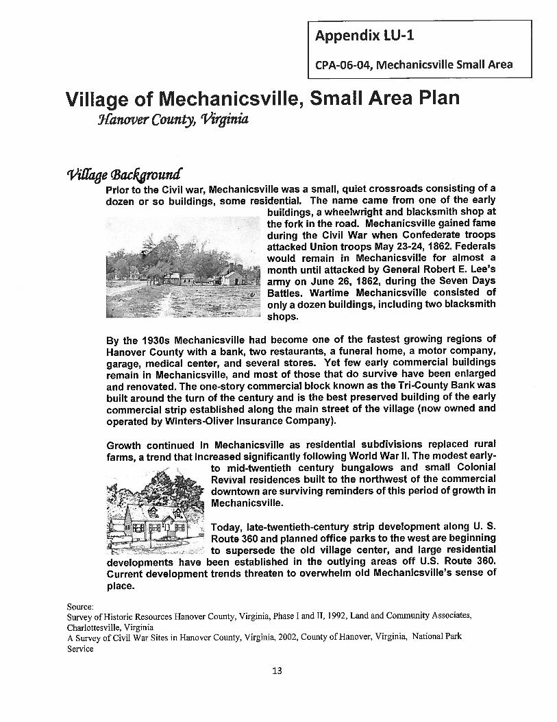
Village of Mechanicsville, Small Area Plan9fanover County, ‘Virginia
‘Viffage cBacIrounéPrior to the Civil war, Mechanicsville was a small, quiet crossroads consisting of adozen or so buildings, some residential. The name came from one of the early
buildings, a wheelwright and blacksmith shop atthe fork in the road. Mechanicsville gained fameduring the Civil War when Confederate troops
,..,,
attacked Union troops May 23-24, 1862. Federalswould remain in Mechanicsville for almost a
_____
month until attacked by General Robert E. Lee’s
• .L&•L army on June 26, 1862, during the Seven Days
j . -
• Battles. Wartime Mechanicsville consisted of.•._cc. - -
-.. — only a dozen buildings, including two blacksmithL . shops.
By the 1930s Mechanicsville had become one of the fastest growing regions ofHanover County with a bank, two restaurants, a funeral home, a motor company,garage, medical center, and several stores. Yet few early commercial buildingsremain in Mechanicsville, and most of those that do survive have been enlargedand renovated. The one-story commercial block known as the Tn-County Bank wasbuilt around the turn of the century and is the best preserved building of the earlycommercial strip established along the main street of the village (now owned andoperated by Winters-Oliver Insurance Company).
Growth continued in Mechanicsville as residential subdivisions replaced ruralfarms, a trend that increased significantly following World War N. The modest early-
to mid-twentieth century bungalows and small ColonialRevval residences built to the northwest of the commercialdowntown are surviving reminders of this period of growth in
.: —4r! Mechanicsville./ •-:
jL -+i . Today, late-twentieth-century strip development along U. S.Route 360 and planned office parks to the west are beginningto supersede the old village center, and large residential
developments have been established in the outlying areas off U.S. Route 360.Current development trends threaten to overwhelm old Mechanicsville’s sense ofplace.
Source:Survey of Historic Resources Hanover County, Virginia, Phase I and II, 1992, Land and Community Associates,
Charlottesville, VirginiaA Survey of Civil War Sites in Hanover County, Virginia, 2002, County of Hanover, Virginia, National Park
Service
Appendix LU-i
CPA-06-04, Mechanicsville Small Area
‘3
TJe Smaiffirea cPtzn
The purpose of the Mechanicsvi(te Small Area Plan is to establish a developmentplan to guide public and private investment in an area defined as the Village ofMechanicsville. The overall intent is to maintain a unique cohesive identity for the Village
and to provide strategies that assist in the long-term stability of the area throughpreservation, revitalization and new development.
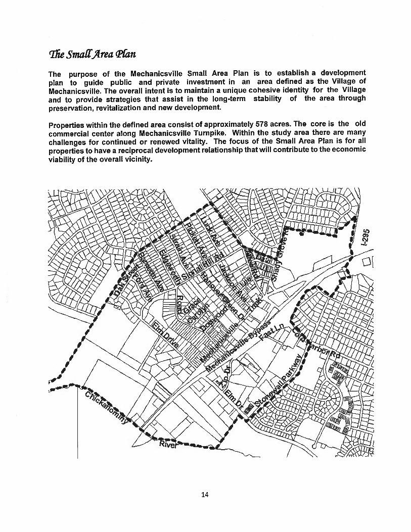
Properties within the defined area consist of approximately 578 acres. The core is the old
commercial center along Mechanicsville Turnpike. Within the study area there are many
challenges for continued or renewed vitality. The focus of the Small Area Plan is for all
properties to have a reciprocal development relationship that will contribute to the economic
viability of the overall vicinity.
14
Stwfy commen’fations
The Village of Mechanicsville, Small Area Plan (the Plan) is intended to serve as a centralreference for future development guidelines. The land use development approach differsfrom the typical automobile oriented development patterns prevalent in Hanover County.Recommendations emphasize greater pedestrian orientation, interconnecting streets, ahuman scale relationship between roads and buildings, and an efficient use of land torestore a small town character for Mechanicsville.
The Plan introduces two “Mixed-Use” designations and integrates these with existingResidential, Commercial and Industrial uses. Development in the context of infill,redevelopment, new development, and neighborhood preservation is addressed.
The elements of the Plan are organized into:
Land Use Transportation
Residential VehicularCommercial I IndustrialMixed-Use
Village Amenities
Pedestrian CirculationStormwater DrainageUtilities
Stutfy qccommeniationsLand Use
Residential
The two land use designations for properties in the highlighted residential area, SuburbanGeneral (1-4 Dwelling Units Per Acre) and Multi-Family (8-15 Dwelling Units Per Acre),generally reflect existing development.
A 2005 report on an architectural survey of the village of Mechanicsville notes“Mechanicsville has a wealth of immediate post World War II architecture that is anoverlooked resource. It is one of the few areas in the county that has a good stock of smallhouses. Although these houses are small, they are well detailed with decorative featuresthat produce a cohesive and in some cases classic appearance.
In the residential areas of Mechanicsville, the individual residences have a fairly good degreeof architectural integrity. Changes largely relate to use of modern synthetic sidings,replacement windows, and additions; however, these have not been so unsympathetic oroverwhelming as to obscure the original architectural character of the houses. More recent
15
mull construction probably has had a greater impact on the residential areas than changesto individual buildings.”
Between the Mechanicsville Recreation Center and Windy Hills Estates subdivision, is anundeveloped 21.3 acre parcel zoned R-1, Single-Family residential; the adopted alignmentfor Route 1250 will create a separation of the southern corner of the parcel. Approximately
6 acres designated as Suburban General are located south of U.S. Route 360. Theproperties are undeveloped and zoned M-f, Light Industrial and B-3, General Commercial,
but development to the zoning potential is questionable since access is through Battlefield
Farms subdivision.
The Multi-Family land use designations encompass Signal Hill and Windmill Way
Apartments, with no area for expansion.
Recommendations Residential Land Use:
o Encourage single-family residential development as infill for the SuburbanGeneral designated properties south of U.S. Route 360.
o Encourage residential development between the MechanicsvilleRecreation Center and Windy Hills Estates subdivision that wouldincorporate open space for areas separated by the proposed Route1250.
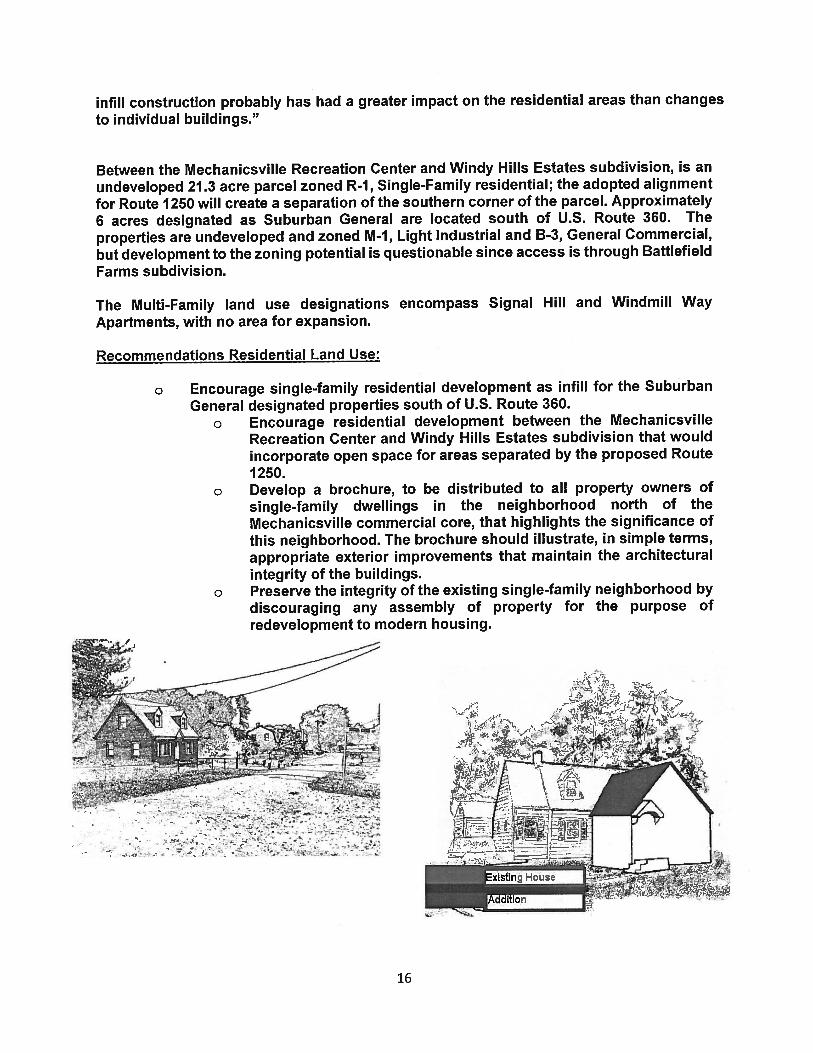
o Develop a brochure, to be distributed to all property owners ofsingle-family dwellings in the neighborhood north of theMechanicsville commercial core, that highlights the significance ofthis neighborhood. The brochure should illustrate, in simple terms,appropriate exterior improvements that maintain the architecturalintegrity of the buildings.
o Preserve the integrity of the existing single-family neighborhood bydiscouraging any assembly of property for the purpose ofredevelopment to modern housing.
4 .
16
Commercial
Existing land uses in the Commercial designation consist of offices along Hanover GreenDrive and office, service, and retail establishments on the south side of U.S. Route 360;two single family dwellings and an industrial use (Hanover Machine and Tool, Inc.) arelocated on Elm Drive and are the only uses not consistent with the Commercialdesignation.
Hanover Green Drive is lined with well-maintained office buildings. The business-oriented
street typically has grass front yards and an overall serene character. The street, which
links Mechanicsville Turnpike’s commercial core on the south with the residential areas to
the north, offers an excellent opportunity to implement a pedestrian friendly corridor.
Additional landscaping with the introduction of such amenities as walkways and street
lighting would enhance and promote pedestrian appeal. New business that could add
diversity and charm to the street should be encouraged, including restaurants with
outdoor dining and small boutiques. The quiet corridor is an attractive business
alternative to the busier thoroughfares in the village.
The Commercial designation south of U.S. Route 360 encompasses limited sites and non
conforming residential properties that comprise approximately 10 acres for new infill
development.
Recommendations Commercial Land Use:
o Ensure new buildings relate appropriately to surrounding developments andstreets to create a cohesive visual identity and attractive street scene.
o Ensure that site circulation promotes contiguous pedestrian and vehiclecirculation for infill and redeveloped properties with safe pedestrianconnections to other uses in the Village.
o Encourage businesses that add diversity and raise pedestrian appeal toHanover Green Drive.
o Discourage uses that require significant outdoor storage.o Promote and support efforts for sidewalks, enhanced landscaping, street
lighting and other pedestrian oriented amenities along Hanover Green Drive.o Buffers for intensity of use between adjoining properties should be designed
to avoid barriers to pedestrian connection and excessive land consumption.Architecture should transition by using similar height and roof form. Avoidplacing nuisance features such as trash receptacles, loading spaces, andparking near residential uses. Utilize small plazas, parks or public gatheringplaces.
Industrial
The industrial area is a gateway into Hanover County and during community worksessions for the Mechanicsville Small Area Plan, a leading concern expressed byparticipants was the unsightly condition of this area. All but approximately 16 acresof the Industrial designation is developed, primarily with auto-serviceestablishments with approximately 40.7 acres underutilized as automobile salvage
17
yards. Outdoor storage of business material is prevalent without adequatescreening. The economic viability of this area is essential for maintainingMechanicsville’s stability.
A 2003 market analysis for the revitalization of the Village states that the industrialarea is key to a revitalization plan for the village. The area has sufficientdevelopable land to accommodate existing auto-related uses from the Villagebusiness core as well as new industrial uses. One concept suggested in the marketanalysis would be to relocate auto-related uses from the Turnpike to the industrialarea so that new retail and office space development can occur along the Turnpike’scommercial core; the new multi-tenant building at the end of Elm Drive was givenas a good example of a better way to house small auto-related firms rather than inthe old free-standing buildings that exist along the Turnpike.
Recommendations Industrial Land Use:
o Encourage regular monitoring and enforcement of existing property maintenance,environmental and zoning ordinances.
o Businesses and property owners along Elm Drive and U.S. Route 360 should beencouraged to improve the appearance by removing or enclosing outdoor storageareas; use landscaping and improved signage; define and consolidate entrances tobusinesses.
o Ensure that site circulation promotes contiguous pedestrian and vehicle circulation forinfill and redeveloped properties with safe pedestrian connections to other uses in theVillage.
o Development controls and design standards should be considered for generating amore attractive industrial setting.
o Promote uses that would be in conformity with the adopted Economic StrategicDevelopment Plan for Hanover County.
Market Analysis Source: Market Analysis for Revitalization Village of Mechanicsville Hanover County, Virginia, S. Patz and Associates, Inc., July, 2003
Mixed Use
The Mixed-Use designation proposes the integration of two or more uses through careful sitelayout and design to provide an efficient use of land with greater emphasis on pedestrianorientation. Uses include, but not limited to, residential, business and office. The approach isa divergence from the single use, auto oriented development pattern that has been typical forthe Village of Mechanicsville throughout the twentieth century. The plan further designates twolevels of Mixed-Use activity: Mixed-Use Residential with emphasis on a neighborhood centerof activity and Mixed-Use Commercial with emphasis on a commercial center of activity.
The area north of the Mechanicsville Bypass designated as Mixed-Use Residential is comprised
of single-family dwellings, apartment units, offices, and imposing public utility structures. Also
within this area is a small residential neighborhood (including Carolyn and Grace Lanes) that
was identified in a 2005 architectural survey as having potential to be a National Register of
18
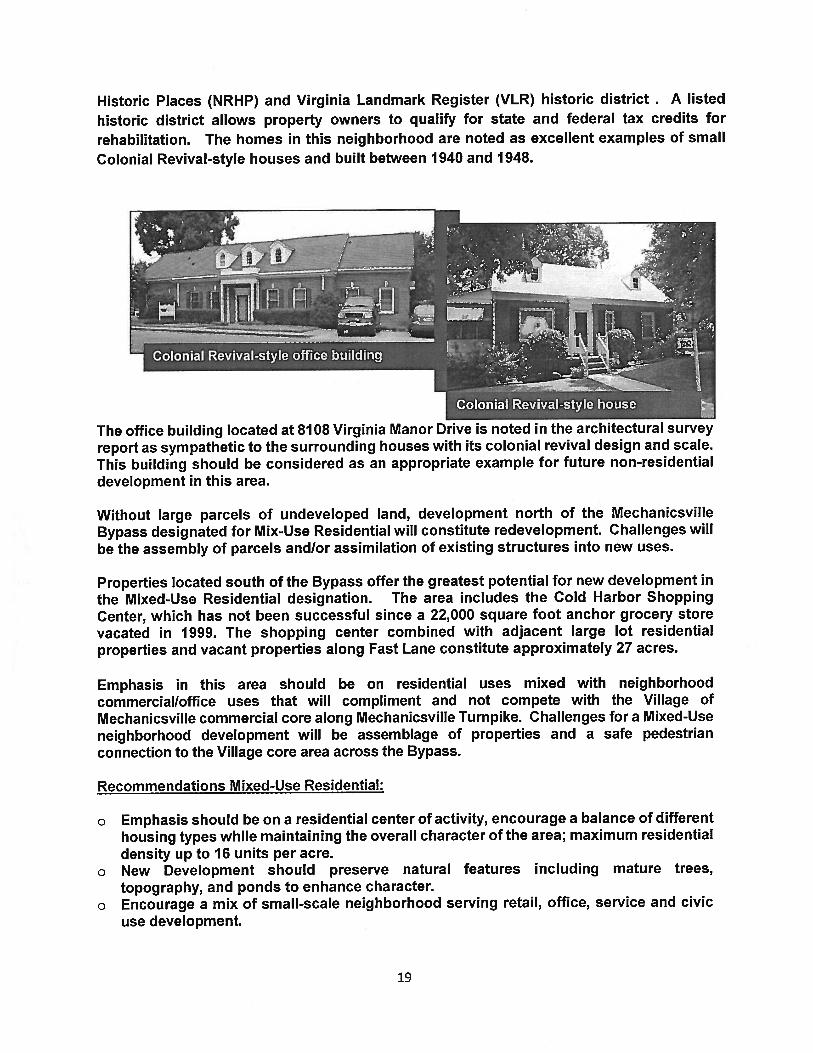
Historic Places (NRHP) and Virginia Landmark Register (VLR) historic district . A listed
historic district allows property owners to qualify for state and federal tax credits for
rehabilitation. The homes in this neighborhood are noted as excellent examples of small
Colonial Revival-style houses and built between 1940 and 1948.
Without large parcels of undeveloped land, development north of the MechanicsvilleBypass designated for Mix-Use Residential will constitute redevelopment. Challenges willbe the assembly of parcels andlor assimilation of existing structures into new uses.
Properties located south of the Bypass offer the greatest potential for new development inthe Mixed-Use Residential designation. The area includes the Cold Harbor ShoppingCenter, which has not been successful since a 22,000 square foot anchor grocery storevacated in 1999. The shopping center combined with adjacent large lot residentialproperties and vacant properties along Fast Lane constitute approximately 27 acres.
Emphasis in this area should be on residential uses mixed with neighborhoodcommercialloffice uses that will compliment and not compete with the Village ofMechanicsville commercial core along Mechanicsville Turnpike. Challenges for a Mixed-Useneighborhood development will be assemblage of properties and a safe pedestrianconnection to the Village core area across the Bypass.
Recommendations Mixed-Use Residential:
o Emphasis should be on a residential center of activity, encourage a balance of differenthousing types while maintaining the overall character of the area; maximum residentialdensity up to 16 units per acre.
o New Development should preserve natural features including mature trees,topography, and ponds to enhance character.
o Encourage a mix of small-scale neighborhood serving retail, office, service and civicuse development.
The office building located at 8108 Virginia Manor Drive is noted in the architectural surveyreport as sympathetic to the surrounding houses with its colonial revival design and scale.This building should be considered as an appropriate example for future non-residentialdevelopment in this area.
19
o Ensure that site circulation promotes contiguous pedestrian and vehicle circulation forinfill and redeveloped properties with safe pedestrian connections to other uses in theVillage.
o Buffers for intensity of use between adjoining properties should be designed to avoidbarriers to pedestrian connection and excessive land consumption. Architectureshould transition by using similar height and roof form. Avoid placing nuisancefeatures such as trash receptacles, loading spaces, and parking near residential uses.Utilize small plazas, parks or public gathering places.
The Mixed-Use Commercial area encompasses the Mechanicsville Turnpike commercial coreand with the exception of a 35 acre undeveloped site at the Interstate 295 interchange, thecontext for Mixed-Use is infill or redevelopment.
A feature article in a February 5, 2006, Richmond Times-Dispatch began with “Welcome tothe village of Mechanicsvilte, home of mom and pop barbershops, bakeries, grocers,jewelers, dry cleaners and druggists.” The article summed up the affection locals have forthe commercial village that is full of history and striving to retain the charm that has beenlost in the newer commercial development further east on U.S. Route 360. The articleaffirms the importance of retaining and enhancing a sense of place for the Village.
The 35 acre undeveloped site at the Interstate 295 interchange presents the least complexsite for new development once access issues have been resolved, since it does not requirethe assembly of developed parcels. During community work sessions, a reoccurringcomment was that this property should capitalize on its visibility from 1-295 with tallerbuildings and possibly a landmark feature that announces “Mechanicsville” in a way thatthe windmill structure does on the western end of the Village.
Recommendations Mixed-Use Commercial:
o Continue to build on community and business support for revitalizing this area. Oneof the biggest assets for success is the affection and nostalgia for the Village.
o Successful revitalization and redevelopment will require firm public commitment toattract private sector development. It is necessary to recognize the complexity ofassembling properties for significant redevelopment and avoid unrealisticexpectations.
o Encourage Mixed-Use zoning to allow flexibility so that buildings and blocks can bedesigned to be interactive with streets and pedestrians.
o Public spaces should be provided that promote community identity including festivals,art, open-air markets, and other forms of entertainment.
o Emphasis should be on a commercial center of activity. Encourage local businessesthat provide new services or merchandise or complement existing businesses. Retailfloor area should be considered when encouraging smaller local businesses.Compact, vertical density should be considered favorably.
o Provide for a variety of housing with a residential density up to 30 units per acre.o Deep setbacks behind large parking areas should be avoided.o Buffers for intensity of use between adjoining properties should be designed to avoid
barriers to pedestrian connection and excessive land consumption. Architectureshould transition by using similar height and roof form. Avoid placing nuisancefeatures such as trash receptacles, loading spaces, and parking near residential uses.Utilize small plazas, parks or public gathering places.
20
o Ensure that site circulation promotes contiguous pedestrian and vehicle circulation forinfill and redeveloped properties with safe pedestrian connections to other uses in theVillage.
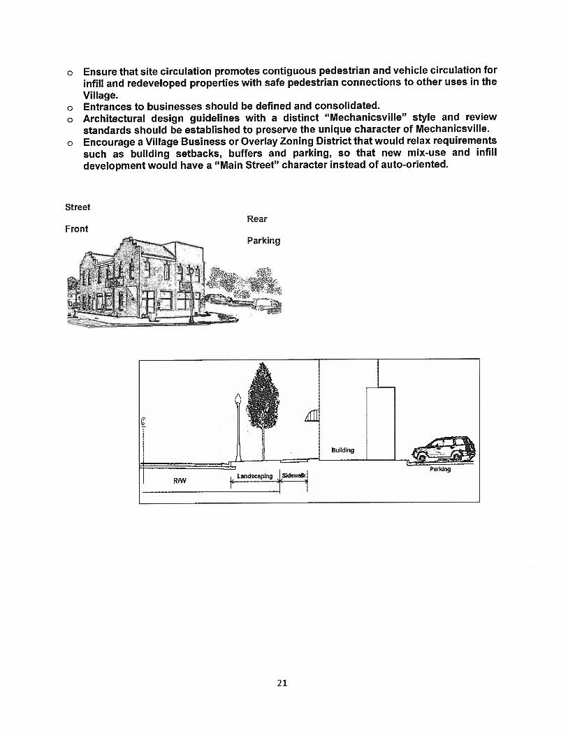
o Entrances to businesses should be defined and consolidated.o Architectural design guidelines with a distinct “Mechanicsville” style and review
standards should be established to preserve the unique character of Mechanicsville.o Encourage a Village Business or Overlay Zoning District that would relax requirements
such as building setbacks, buffers and parking, so that new mix-use and infilldevelopment would have a “Main Street” character instead of auto-oriented.
StreetRear
Front
Building
Landscaping JSiUewalkJParking
21
F’)
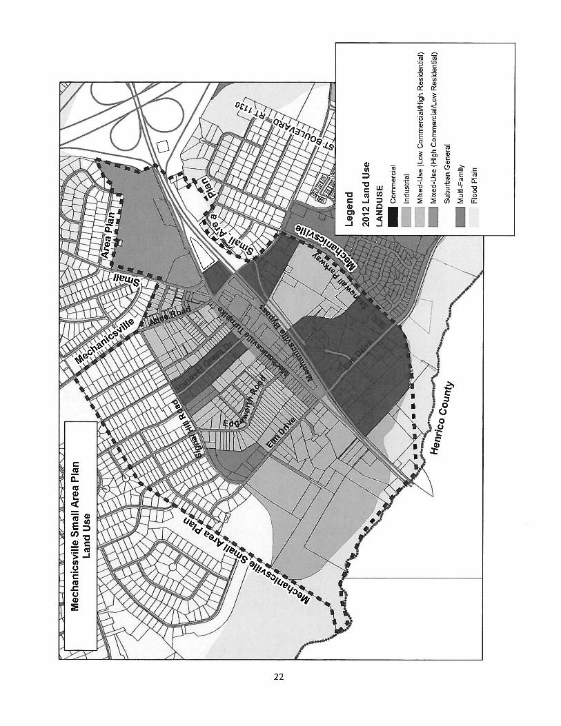
Lan
dU
se
\\\
Leg
end
2012
Lan
dU
se
LA
ND
USE
Com
mer
cial
Indu
stri
al
Mix
ed-U
se(L
owC
omm
erci
al/H
igh
Res
iden
tial
)
Mix
ed-U
se(H
igh
Com
mer
cial
/Low
Res
iden
tial
)
Sub
urba
nG
ener
al
Mul
ti-Fa
mily
Flo
odPl
ain
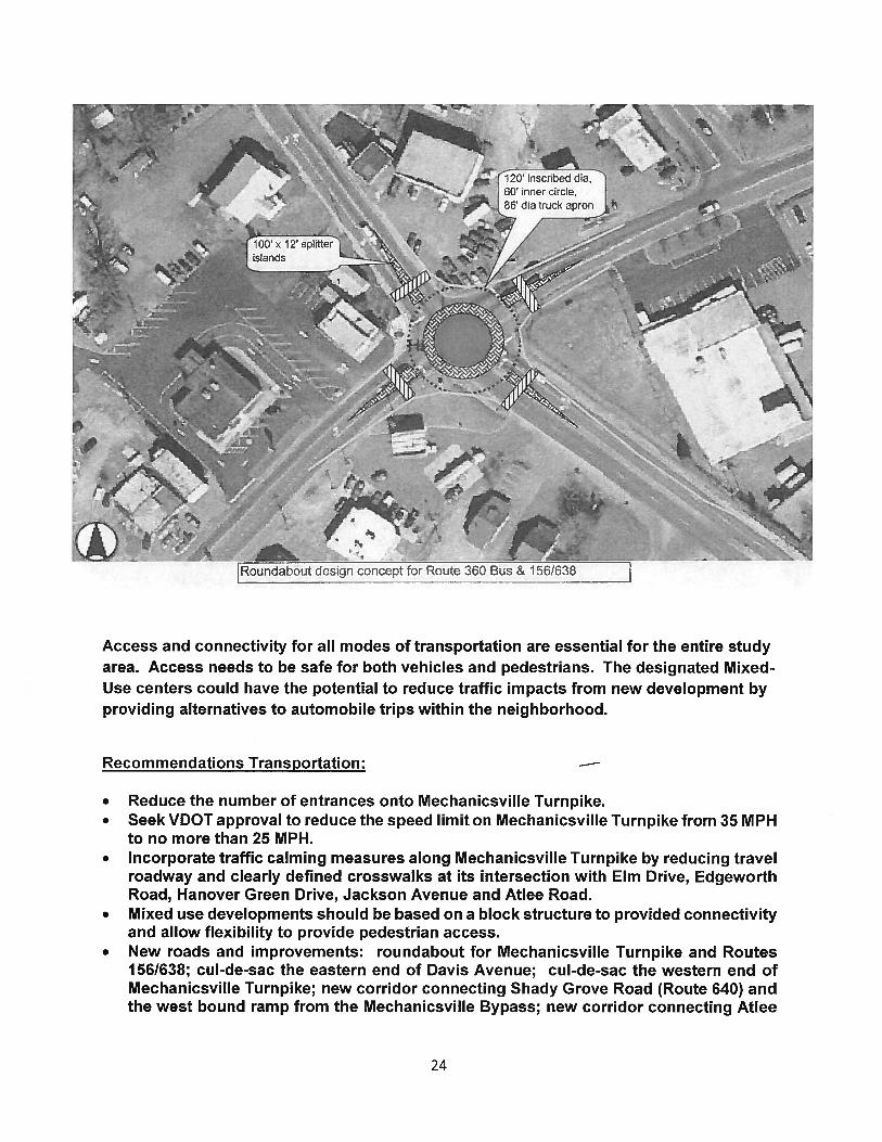
Stuly commenéationsTransportation
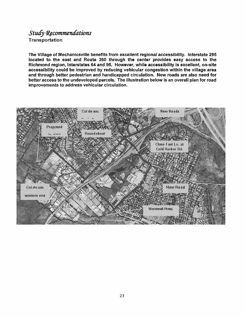
The Village of Mechanicsville benefits from excellent regional accessibility. Interstate 295located to the east and Route 360 through the center provides easy access to theRichmond region, Interstates 64 and 95. However, while accessibility is excellent, on-siteaccessibility could be improved by reducing vehicular congestion within the village areaand through better pedestrian and handicapped circulation. New roads are also need forbetter access to the undeveloped parcels. The illustration below is an overall plan for roadimprovements to address vehicular circulation.
23
f scnbedd‘
2$hJ
,.‘J._;•.L
L
.‘..
“:
‘%
(,
____
Roundabout design concept for Route 360 Bus & 156/638
Access and connectivity for all modes of transportation are essential for the entire studyarea. Access needs to be safe for both vehicles and pedestrians. The designated Mixed-Use centers could have the potential to reduce traffic impacts from new development byproviding alternatives to automobile trips within the neighborhood.
Recommendations Transportation:
• Reduce the number of entrances onto Mechanicsville Turnpike.• Seek VDOT approval to reduce the speed limit on Mechanicsville Turnpike from 35 MPH
to no more than 25 MPH.• Incorporate traffic calming measures along Mechanicsville Turnpike by reducing travel
roadway and clearly defined crosswalks at its intersection with Elm Drive, EdgeworthRoad, Hanover Green Drive, Jackson Avenue and Atlee Road.
• Mixed use developments should be based on a block structure to provided connectivityand allow flexibility to provide pedestrian access.
• New roads and improvements: roundabout for Mechanicsville Turnpike and Routes1561638; cul-de-sac the eastern end of Davis Avenue; cul-de-sac the western end ofMechanicsville Turnpike; new corridor connecting Shady Grove Road (Route 640) andthe west bound ramp from the Mechanicsville Bypass; new corridor connecting Atlee
x 12’ splitter I
V
24
Road (Route 638) to Shady Grove Road (Route 640); close Fast Lane at Cold HarborRoad (Route 156) and redirect to Stonewall Parkway.
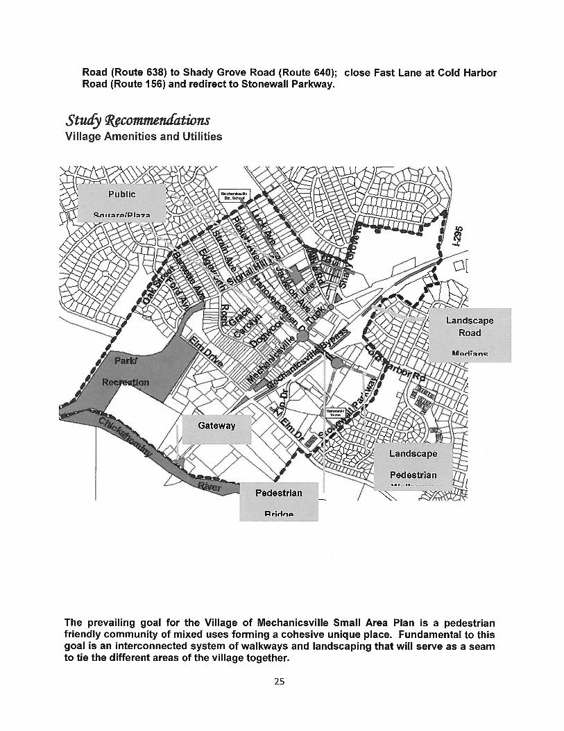
Stuiy commen(ationsVillage Amenities and Utilities
The prevailing goal for the Village of Mechanicsville Small Area Plan is a pedestrianfriendly community of mixed uses forming a cohesive unique place. Fundamental to thisgoal is an interconnected system of walkways and landscaping that will serve as a seamto tie the different areas of the village together.
Pridnc
25
Emphasis should be placed equally on pedestrian access as for automobile access withwell-designed, safe walkways and crosswalks.
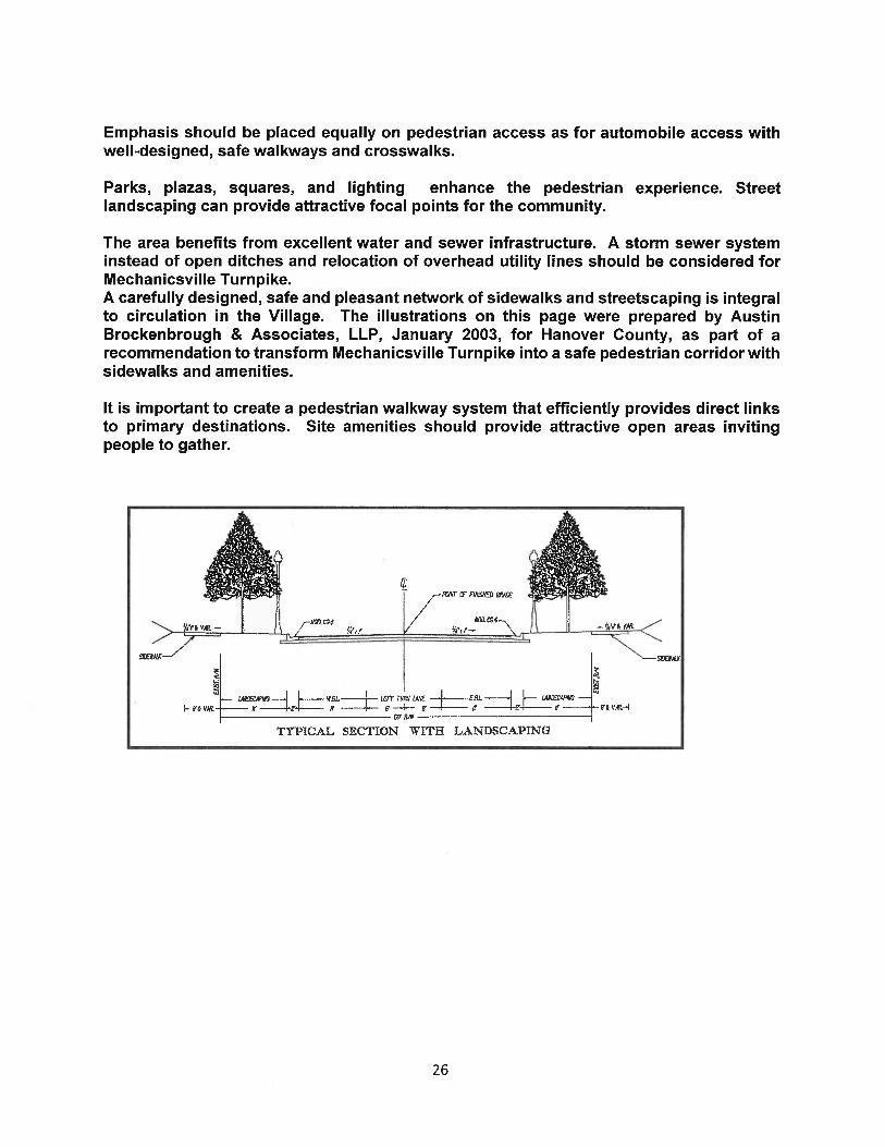
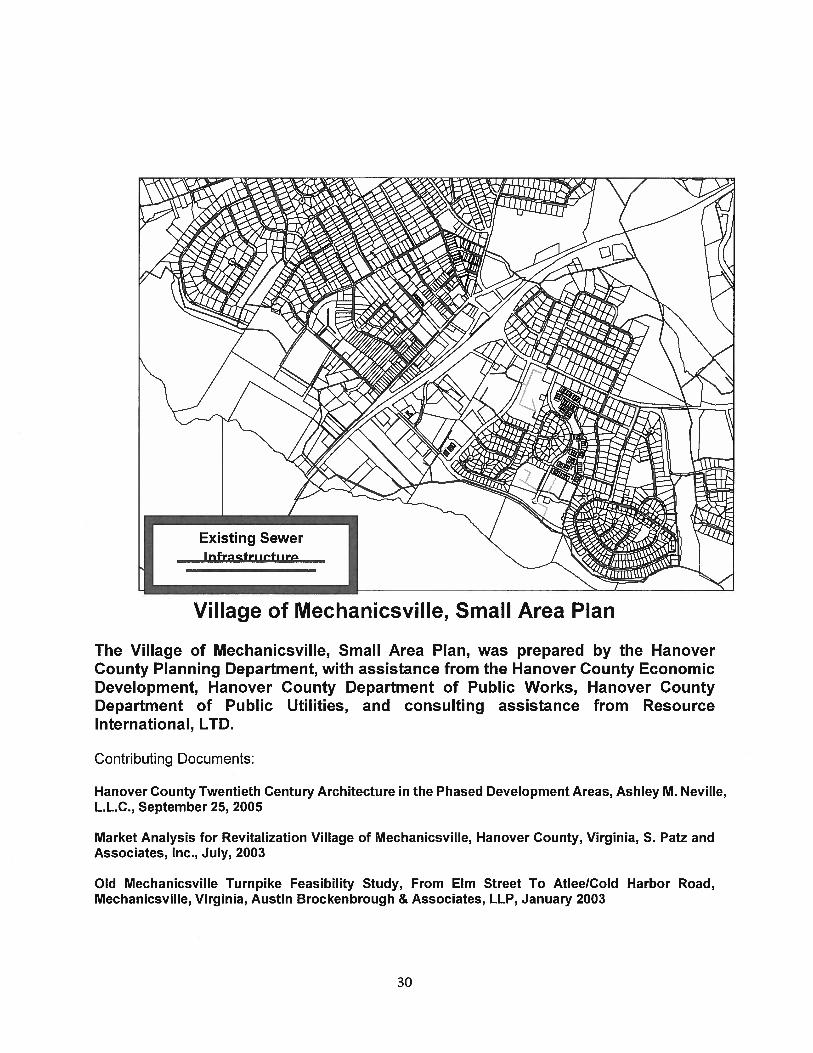
Parks, plazas, squares, and lighting enhance the pedestrian experience. Streetlandscaping can provide attractive focal points for the community.
The area benefits from excellent water and sewer infrastructure. A storm sewer systeminstead of open ditches and relocation of overhead utility lines should be considered forMechanicsville Turnpike.A carefully designed, safe and pleasant network of sidewalks and streetscaping is integralto circulation in the Village. The illustrations on this page were prepared by AustinBrockenbrough & Associates, LLP, January 2003, for Hanover County, as part of arecommendation to transform Mechanicsville Turnpike into a safe pedestrian corridor withsidewalks and amenities.
It is important to create a pedestrian walkway system that efficiently provides direct linksto primary destinations. Site amenities should provide attractive open areas invitingpeople to gather.
I III
— LMD5C —.j I—-—- w& — LEFT TL’TL L4NE -{ - E& —i —
I. 6& Vlf — fl —rE4--—--- LF —# c IT —-E H’
TYPICAL SECTION WITH LANDSCAPING
26
I /i L_i L :H
-I0
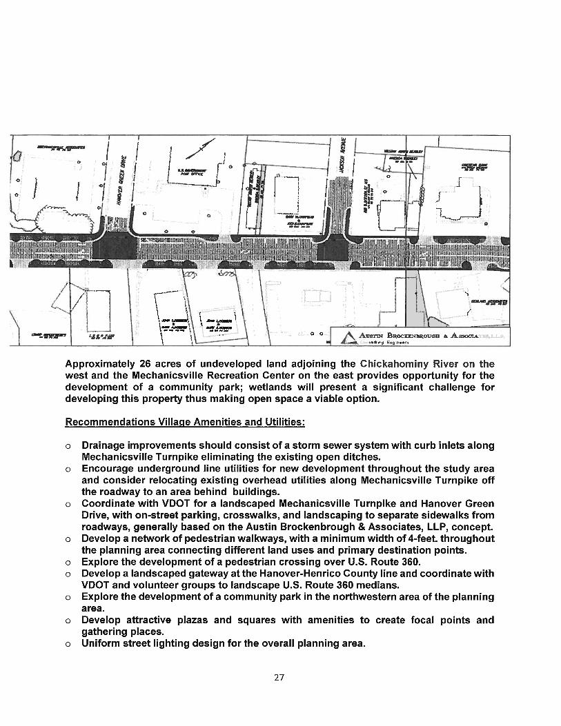
Approximately 26 acres of undeveloped land adjoining the Chickahominy River on thewest and the Mechanicsville Recreation Center on the east provides opportunity for thedevelopment of a community park; wetlands will present a significant challenge fordeveloping this property thus making open space a viable option.
Recommendations Village Amenities and Utilities:
o Drainage improvements should consist of a storm sewer system with curb inlets alongMechanicsville Turnpike eliminating the existing open ditches.
o Encourage underground line utilities for new development throughout the study areaand consider relocating existing overhead utilities along Mechanicsville Turnpike offthe roadway to an area behind buildings.
o Coordinate with VDOT for a landscaped Mechanicsville Turnpike and Hanover GreenDrive, with on-street parking, crosswalks, and landscaping to separate sidewalks fromroadways, generally based on the Austin Brockenbrough & Associates, LLP, concept.
o Develop a network of pedestrian walkways, with a minimum width of 4-feet. throughoutthe planning area connecting different land uses and primary destination points.
o Explore the development of a pedestrian crossing over U.S. Route 360.o Develop a landscaped gateway at the Hanover-Henrico County line and coordinate with
VDOT and volunteer groups to landscape U.S. Route 360 medians.o Explore the development of a community park in the northwestern area of the planning
area.o Develop attractive plazas and squares with amenities to create focal points and
gathering places.o Uniform street lighting design for the overall planning area.
0
;°i II
0 0
I0
/
/— I
‘I.
-
\00
o
._j....j rI
AusTm ouoi & Asocj..k1s,1.j.p.
27
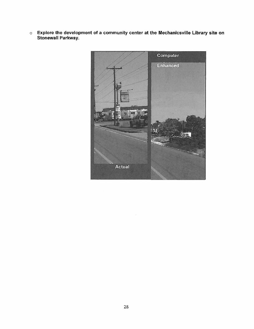
o Explore the development of a community center at the Mechanicsville Library site onStonewall Parkway.
28
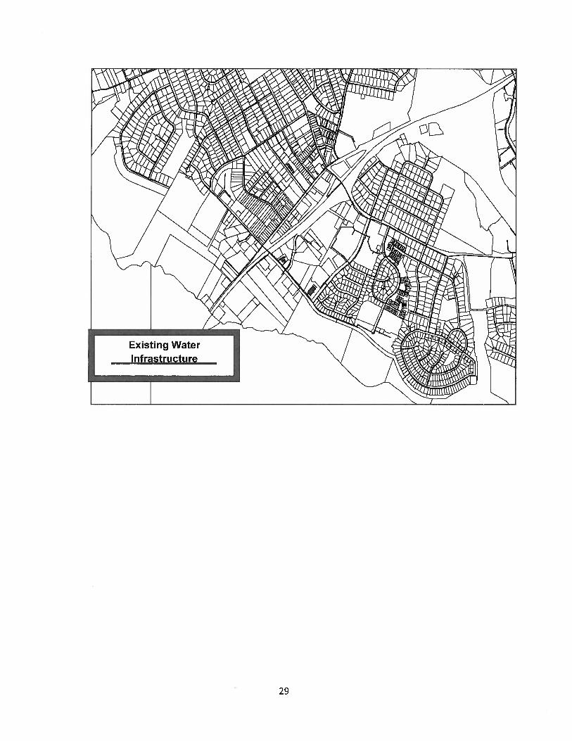
Existing WaterInfrastructure
29
Village of Mechanicsville, Small Area Plan
The Village of Mechanicsville, Small Area Plan, was prepared by the HanoverCounty Planning Department, with assistance from the Hanover County EconomicDevelopment, Hanover County Department of Public Works, Hanover CountyDepartment of Public Utilities, and consulting assistance from ResourceInternational, LTD.
Contributing Documents:
Hanover County Twentieth Century Architecture in the Phased Development Areas, Ashley M. Neville,L.L.C., September 25, 2005
Market Analysis for Revitalization Village of Mechanicsville, Hanover County, Virginia, S. Patz andAssociates, Inc., July, 2003
Old Mechanicsville Turnpike Feasibility Study, From Elm Street To AtleeICoId Harbor Road,Mechanicsville, Virginia, Austin Brockenbrough & Associates, LLP, January 2003
Existing SewerI nfecfri i,f, ir
30